City
of hobart
AGENDA
City Planning Committee Meeting
Open Portion
Monday, 27 August 2018
at 5:00 pm
Lady Osborne Room, Town Hall
City
of hobart
AGENDA
City Planning Committee Meeting
Open Portion
Monday, 27 August 2018
at 5:00 pm
Lady Osborne Room, Town Hall
THE MISSION
Our mission is to ensure good governance of our capital City.
THE VALUES
The Council is:
|
about people |
We value people – our community, our customers and colleagues. |
|
professional |
We take pride in our work. |
|
enterprising |
We look for ways to create value. |
|
responsive |
We’re accessible and focused on service. |
|
inclusive |
We respect diversity in people and ideas. |
|
making a difference |
We recognise that everything we do shapes Hobart’s future. |
|
|
Agenda (Open Portion) City Planning Committee Meeting |
Page 3 |
|
|
27/8/2018 |
|
Business listed on the agenda is to be conducted in the order in which it is set out, unless the committee by simple majority determines otherwise.
APOLOGIES AND LEAVE OF ABSENCE
1. Co-Option of a Committee Member in the event of a vacancy
3. Consideration of Supplementary Items
4. Indications of Pecuniary and Conflicts of Interest
6. Planning Authority Items - Consideration of Items With Deputations
7. Committee Acting as Planning Authority
7.1 Applications under the Hobart Interim Planning Scheme 2015
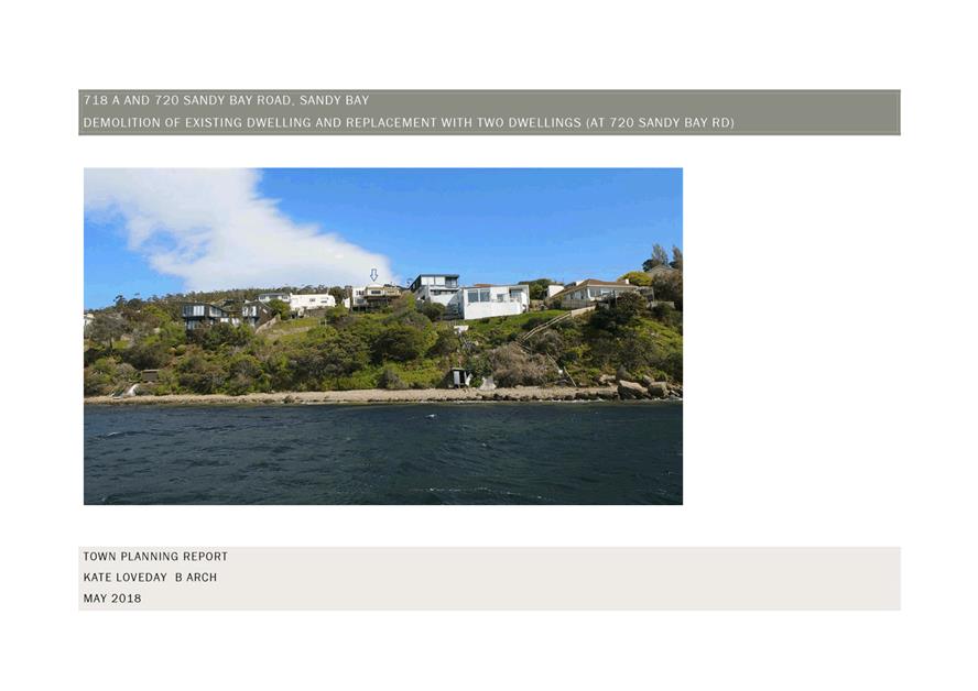
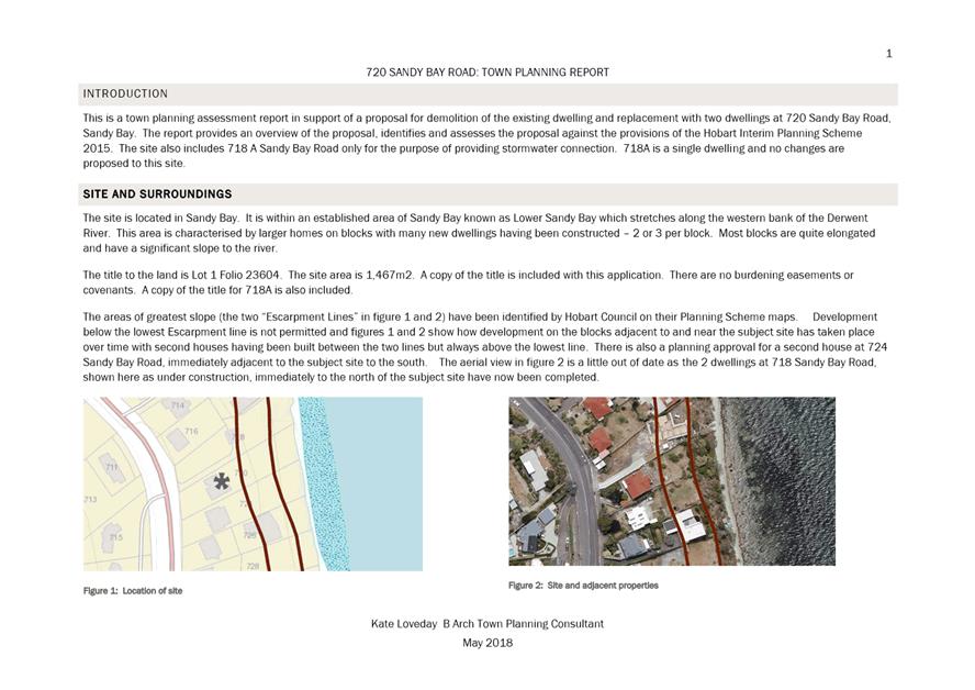
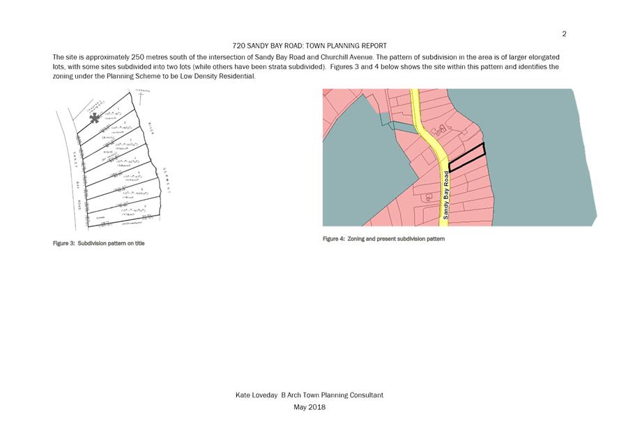
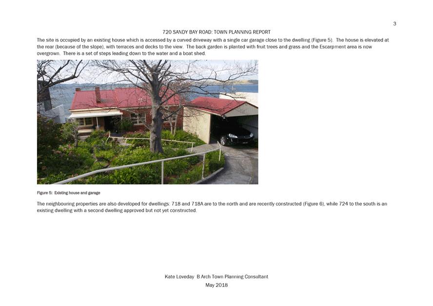
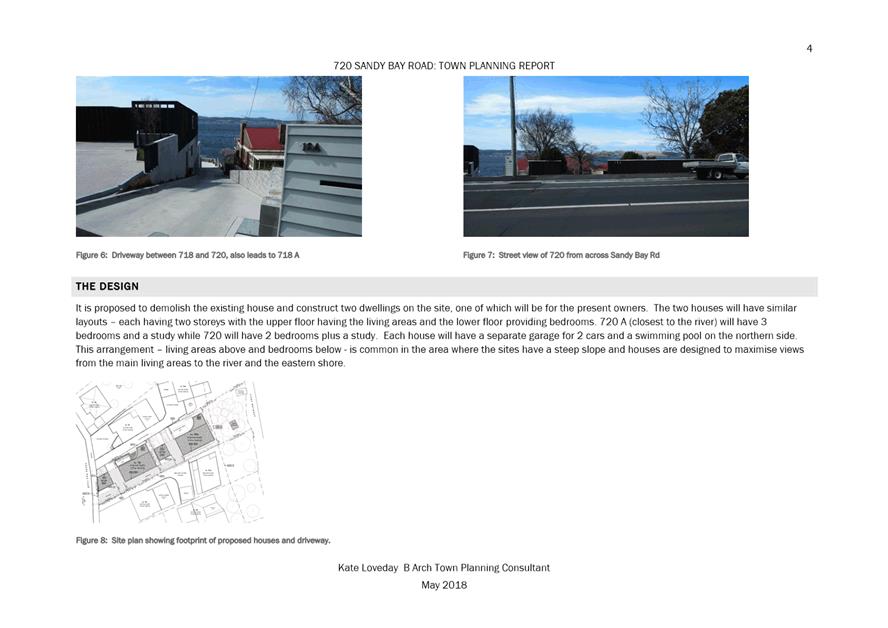
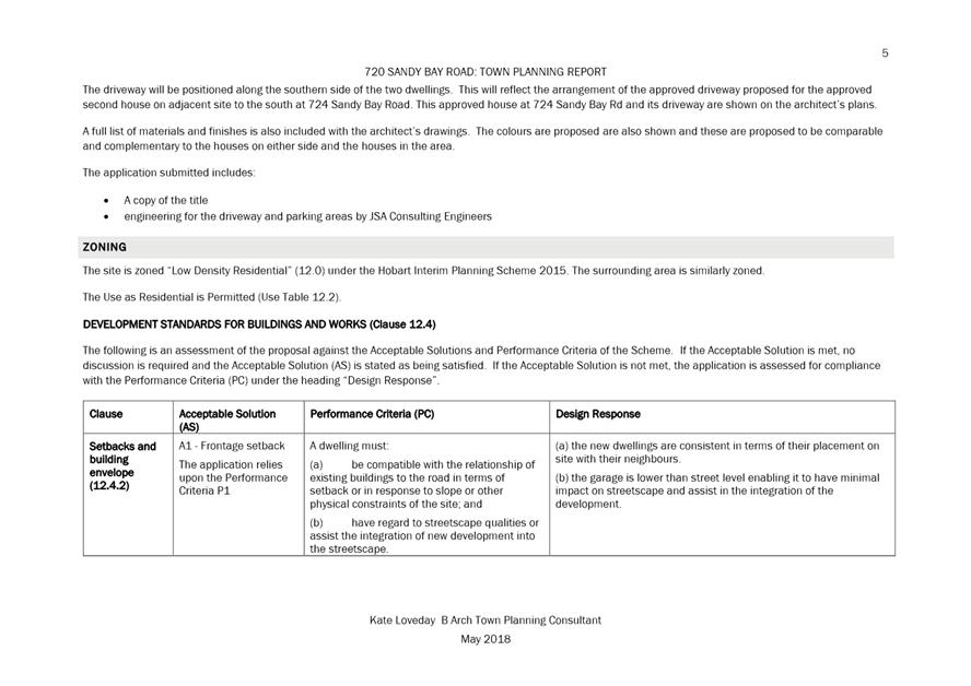
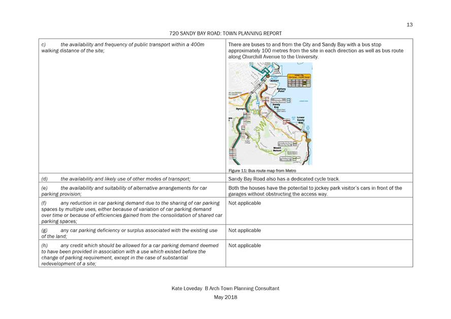
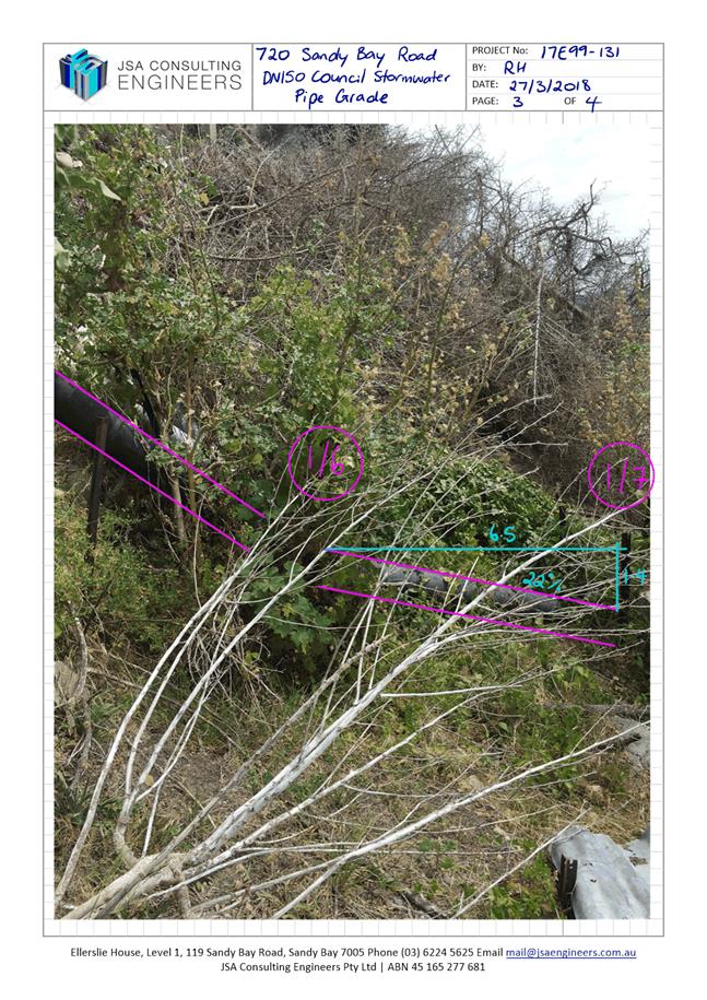
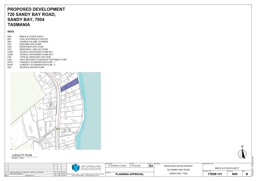
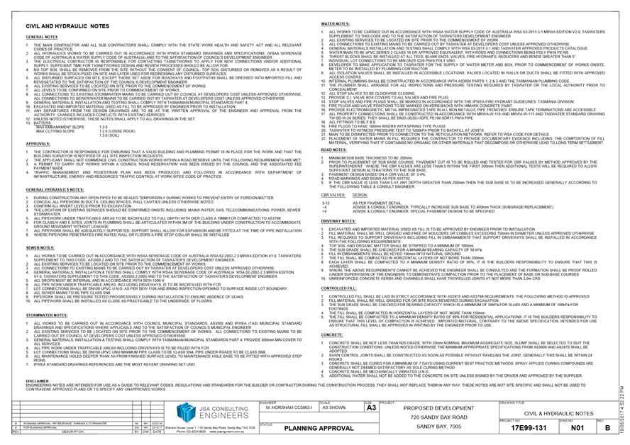
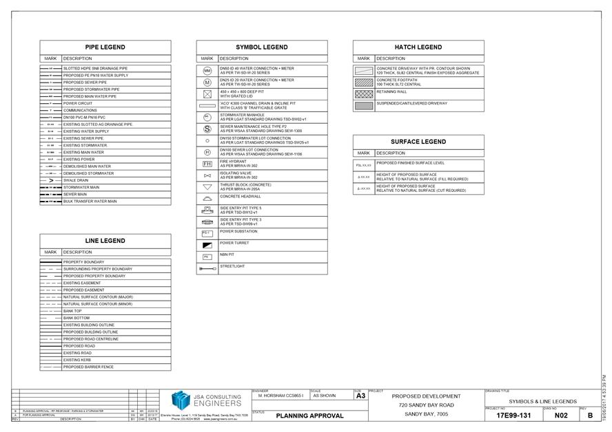
7.1.1 720 Sandy Bay Road and 718A Sandy Bay Road, Sandy Bay - Demolition and Multiple Dwelling
7.1.3 412 Elizabeth Street, North Hobart - Demolition and New Public Toilets
7.1.4 114 Augusta Road, Lenah Valley - Partial Demolition and Front Fencing
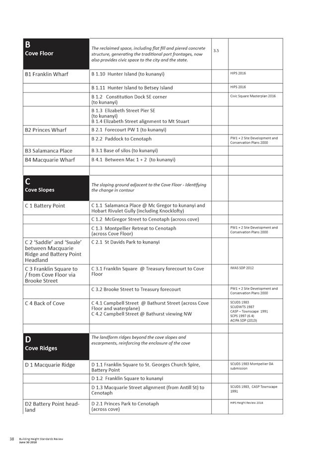
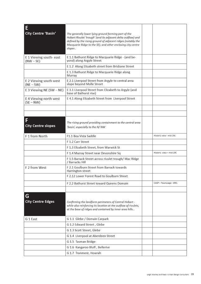
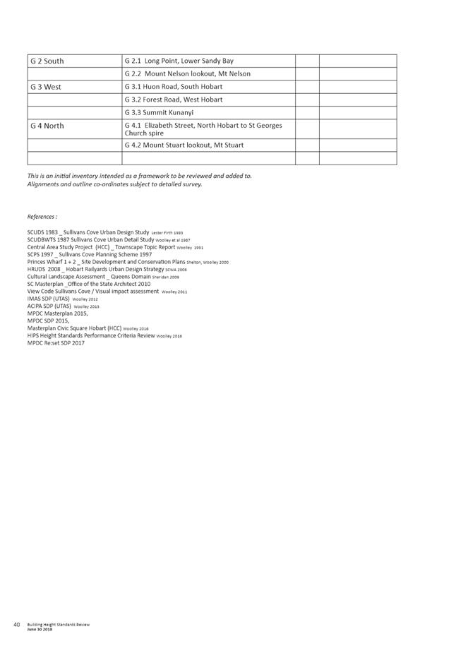
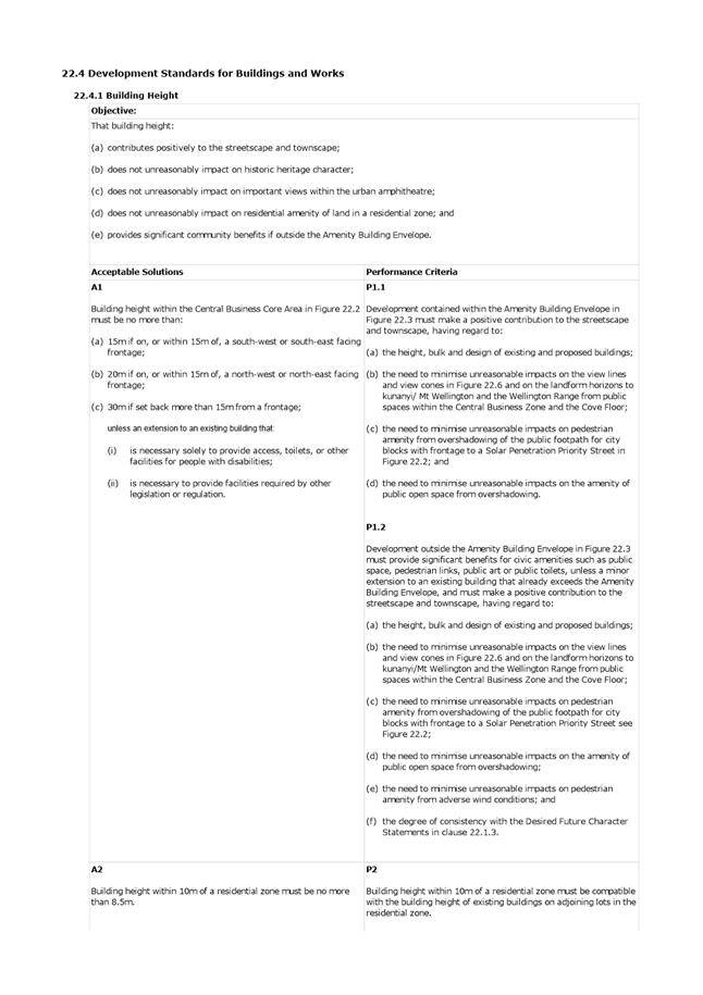
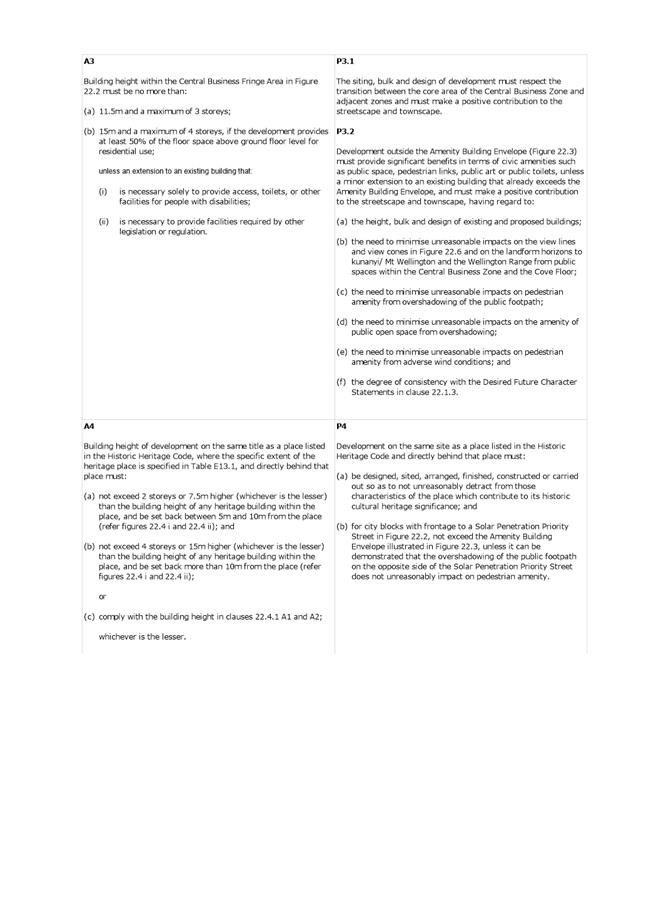
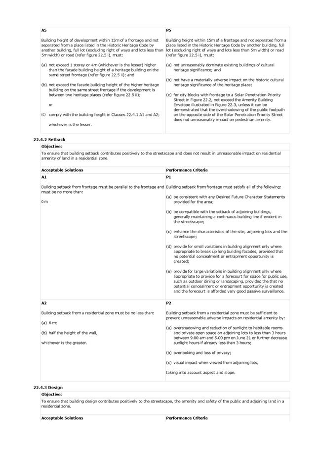
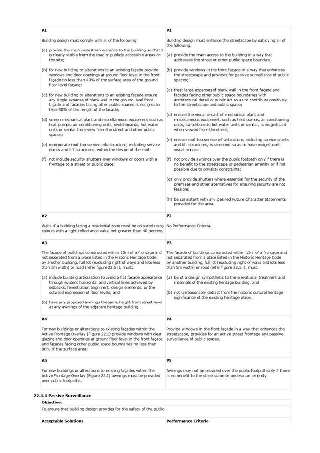
8.1 Central Hobart Building Height Standards Review Project - Proposed Planning Scheme Amendments
8.2 Dr Edward Hall Grants 2018
8.3 Delegated Decisions Report (Planning)
8.4 City Planning - Advertising Report
10. Closed Portion Of The Meeting
|
|
Agenda (Open Portion) City Planning Committee Meeting |
Page 5 |
|
|
27/8/2018 |
|
City Planning Committee Meeting (Open Portion) held Monday, 27 August 2018 at 5:00 pm in the Lady Osborne Room, Town Hall.
|
COMMITTEE MEMBERS Briscoe (Chairman) Ruzicka Burnet Denison
ALDERMEN Lord Mayor Christie Deputy Lord Mayor Sexton Zucco Cocker Thomas Reynolds Harvey |
Apologies:
Leave of Absence: Nil.
|
|
The minutes of the Open Portion of the City Planning Committee meeting held on Monday, 13 August 2018, are submitted for confirming as an accurate record.
|
Ref: Part 2, Regulation 8(6) of the Local Government (Meeting Procedures) Regulations 2015.
|
That the Committee resolve to deal with any supplementary items not appearing on the agenda, as reported by the General Manager.
|
Ref: Part 2, Regulation 8(7) of the Local Government (Meeting Procedures) Regulations 2015.
Aldermen are requested to indicate where they may have any pecuniary or conflict of interest in respect to any matter appearing on the agenda, or any supplementary item to the agenda, which the committee has resolved to deal with.
Regulation 15 of the Local Government (Meeting Procedures) Regulations 2015.
A committee may close a part of a meeting to the public where a matter to be discussed falls within 15(2) of the above regulations.
In the event that the committee transfer an item to the closed portion, the reasons for doing so should be stated.
Are there any items which should be transferred from this agenda to the closed portion of the agenda, or from the closed to the open portion of the agenda?
In accordance with the requirements of Part 2 Regulation 8(3) of the Local Government (Meeting Procedures) Regulations 2015, the General Manager is to arrange the agenda so that the planning authority items are sequential.
In accordance with Part 2 Regulation 8(4) of the Local Government (Meeting Procedures) Regulations 2015, the Committee by simple majority may change the order of any of the items listed on the agenda, but in the case of planning items they must still be considered sequentially – in other words they still have to be dealt with as a single group on the agenda.
Where deputations are to be received in respect to planning items, past practice has been to move consideration of these items to the beginning of the meeting.
RECOMMENDATION
That in accordance with Regulation 8(4) of the Local Government (Meeting Procedures) Regulations 2015, the Committee resolve to deal with any items which have deputations by members of the public regarding any planning matter listed on the agenda, to be taken out of sequence in order to deal with deputations at the beginning of the meeting.
|
|
Agenda (Open Portion) City Planning Committee Meeting |
Page 7 |
|
|
27/8/2018 |
|
In accordance with the provisions of Part 2 Regulation 25 of the Local Government (Meeting Procedures) Regulations 2015, the intention of the Committee to act as a planning authority pursuant to the Land Use Planning and Approvals Act 1993 is to be noted.
In accordance with Regulation 25, the Committee will act as a planning authority in respect to those matters appearing under this heading on the agenda, inclusive of any supplementary items.
The Committee is reminded that in order to comply with Regulation 25(2), the General Manager is to ensure that the reasons for a decision by a Council or Council Committee acting as a planning authority are recorded in the minutes.
|
Agenda (Open Portion) City Planning Committee Meeting |
Page 8 |
|
|
|
27/8/2018 |
|
7.1 Applications under the Hobart Interim Planning Scheme 2015
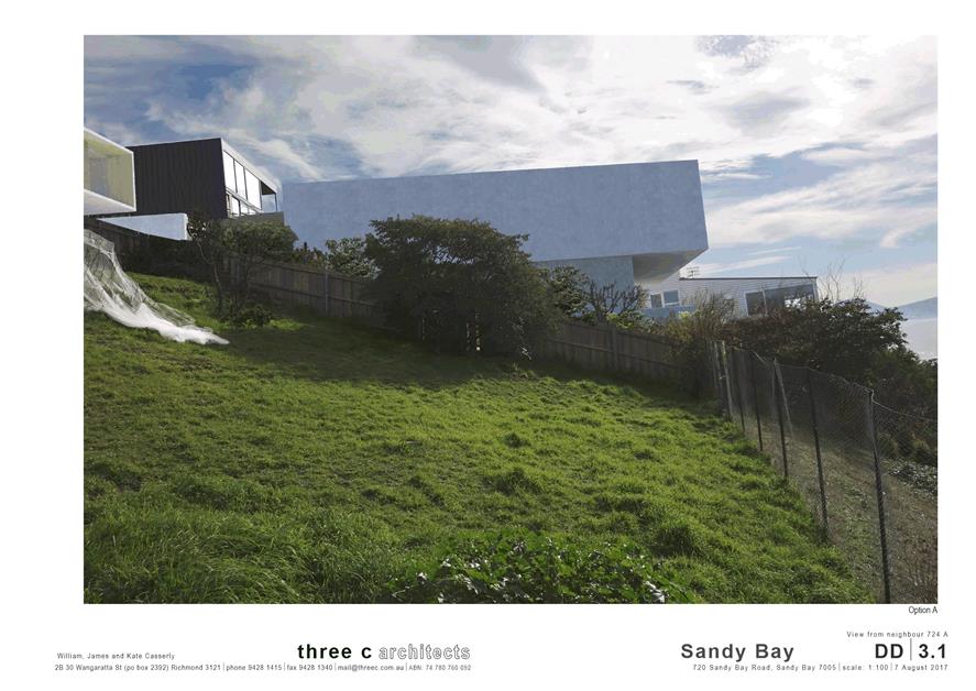
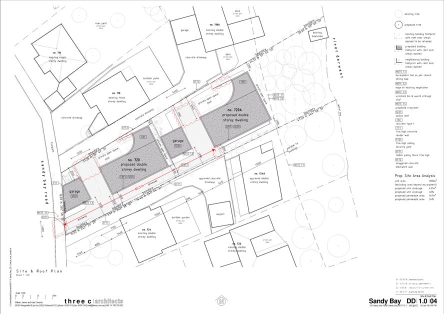
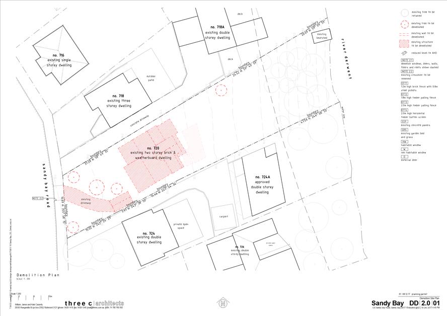
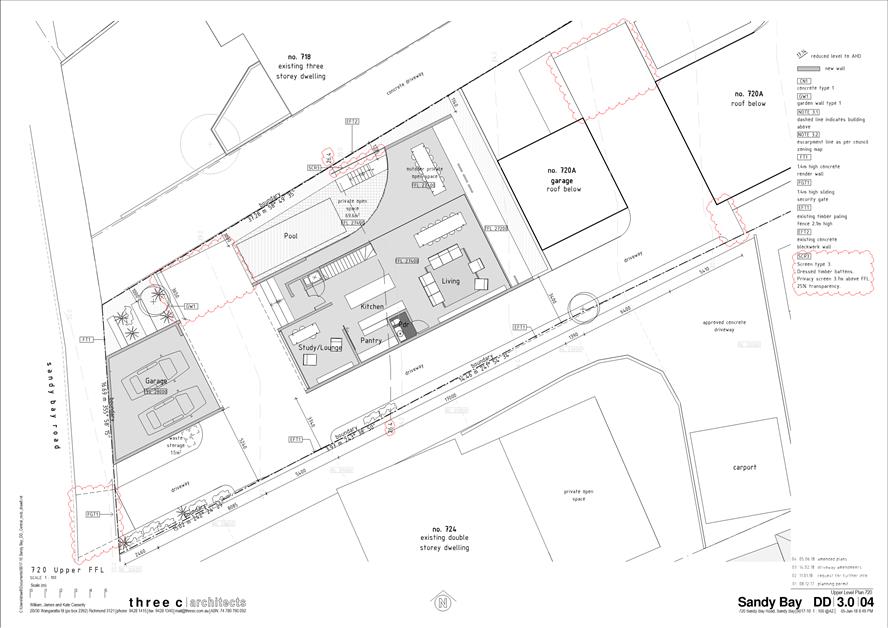
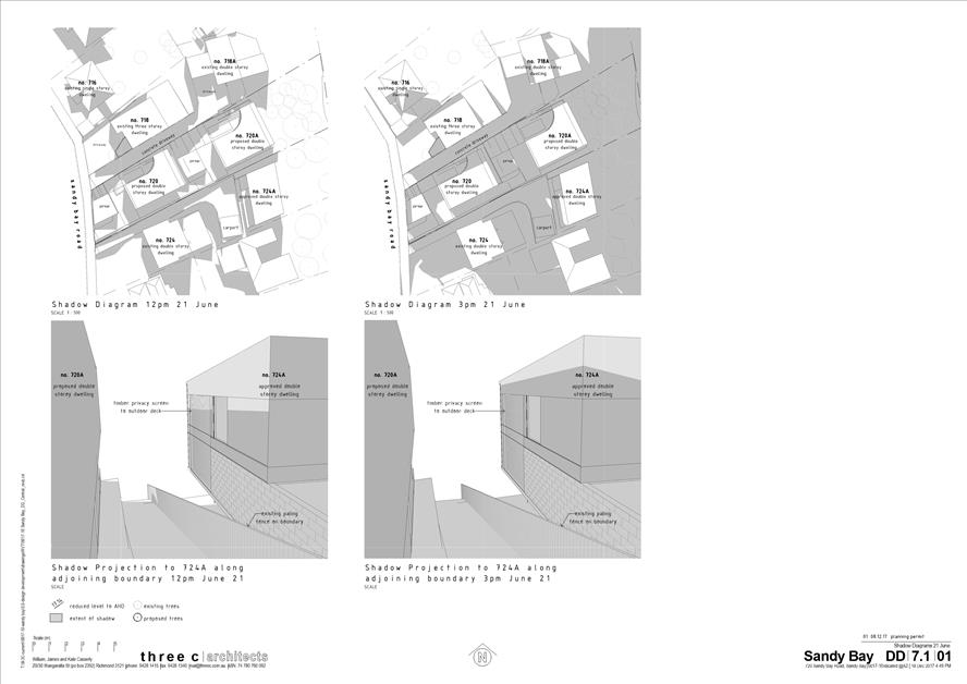
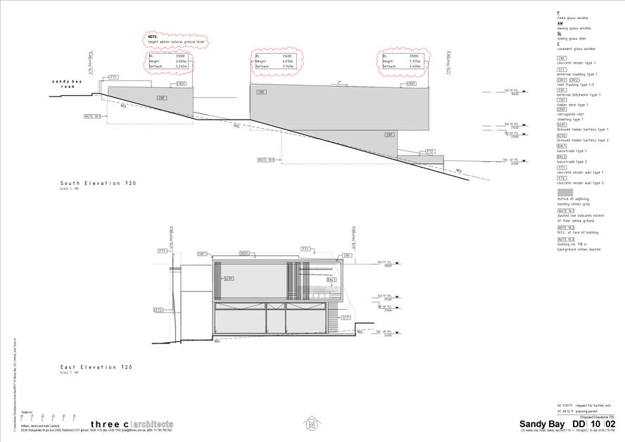
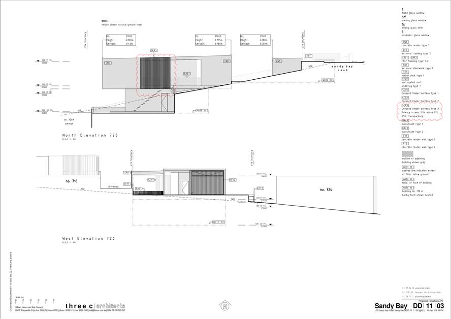
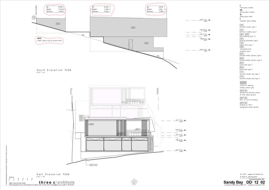
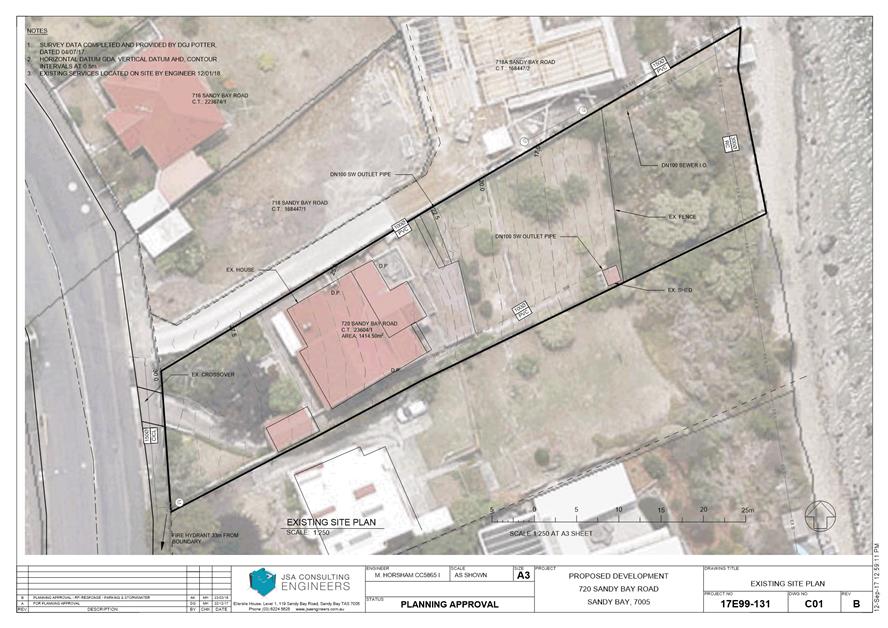
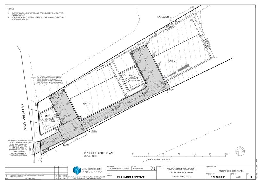
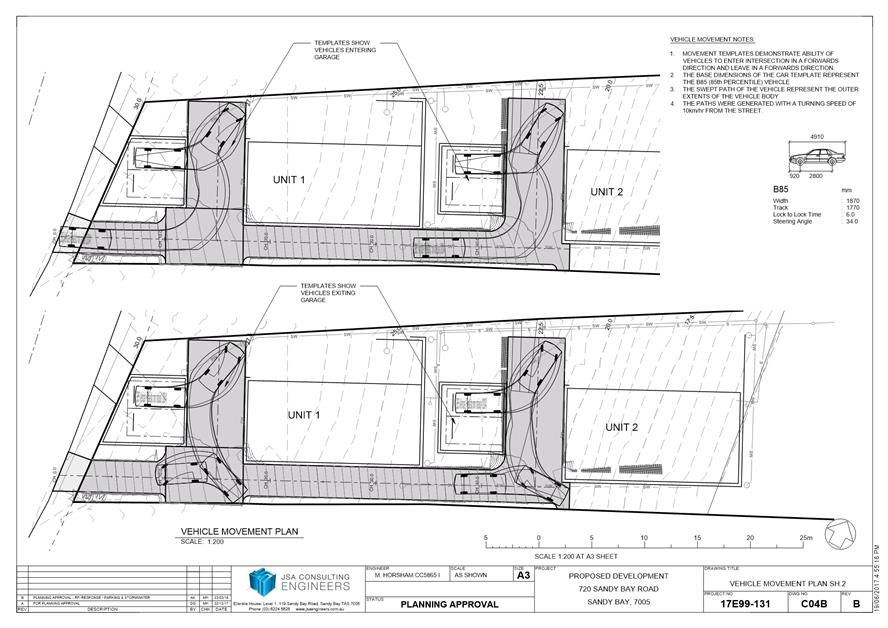
7.1.1 720 Sandy Bay Road and 718A Sandy Bay Road, Sandy Bay - Demolition and Multiple Dwelling
Address: 720 Sandy Bay Road and 718A Sandy Bay Road, Sandy Bay
Proposal: Demolition and Multiple Dwelling
Expiry Date: 14 September 2018
Extension of Time: Not applicable
Author: Helen Ayers
|
REcommendation That: Pursuant to the Hobart Interim Planning Scheme 2015, the Council approve the application for demolition and multiple dwellings at 720 Sandy Bay Road and 718A Sandy Bay Road, Sandy Bay for the reasons outlined in the officer’s report and a permit containing the following conditions be issued:
GEN
The use and/or development must be substantially in accordance with the documents and drawings that comprise PLN171069 720 SANDY BAY ROAD SANDY BAY TAS 7005 Final Planning Documents, except where modified below.
Reason for condition
To clarify the scope of the permit.
TW
The use and/or development must comply with the requirements of TasWater as detailed in the form Submission to Planning Authority Notice, Reference No. TWDA 2018/00001HCC dated 24/05/2018 as attached to the permit.
Reason for condition
To clarify the scope of the permit.
PLN s1
All external building surfaces must be clad in muted, nonreflective colours and materials.
Reason for condition
To ensure compliance with clause 12.4.10 of the Hobart Interim Planning Scheme 2015.
PLN s4
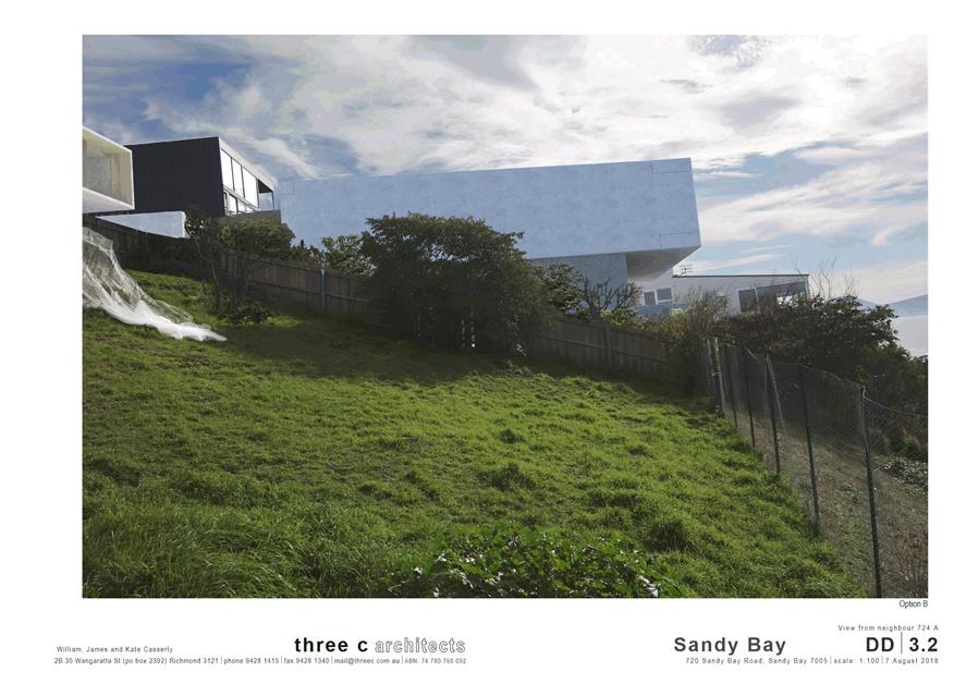
The southern elevation of the waterside dwelling must have different cladding to the lower and upper levels.
Prior to the issue of any approval under the Building Act 2016, amended plans must be submitted to and approved by the Council's Director City Planning. The plans must show:
1. Darker cladding for the lower level of the southern elevation of the waterside dwelling. 2. Lighter, textured cladding for the upper level of the southern elevation of the waterside dwelling.
All work required by this condition must be undertaken in accordance with the approved amended plans.
Reason for condition
To ensure that there is not an unreasonable loss of amenity to adjacent properties through the scale and massing of the building.
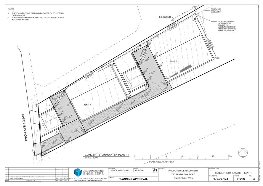
ENG sw1
All stormwater from the proposed development (including but not limited to: roofed areas, ag drains, retaining wall ag drains and impervious surfaces such as driveways and paved areas) must be drained to the Council’s stormwater infrastructure prior to first occupation.
Reason for condition
To ensure that stormwater from the site will be discharged to a suitable Council approved outlet.
ENG sw4
The new storm water connection must be constructed and any existing abandoned connections sealed by the Council at the owner’s expense, prior to the first occupation.
Detailed engineering drawings must be submitted and approved, prior to commencement of work. The detailed engineering drawings must include:
1. the location of the proposed connection; and 2. the size of the connection appropriate to satisfy the needs of the development.
All work required by this condition must be undertaken in accordance with the approved detailed engineering drawings.
Advice: The applicant is advised to submit detailed design drawings via a Council City Infrastructure Division application for a new stormwater connection. If detailed design to satisfy this condition is submitted via the planning condition endorsement process there may be fees associated with the assessment, and once approved the applicant will still need to submit an application for a new stormwater connection with Council City Infrastructure Division.
Where building / plumbing approval is also required, it is recommended that documentation to satisfy this condition is submitted well before submitting documentation for building/plumbing approval. Failure to address planning condition requirements prior to submitting for building/plumbing approval may result in unexpected delays.
If the proposed stormwater connection works will occur on third party property, the applicant is advised that they are required (separate to this planning permit) to obtain the relevant permissions necessary under any other Act in order to undertake the works.
Reason for condition
To ensure the site is drained adequately.
ENG 2a
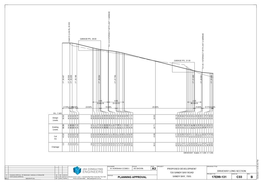
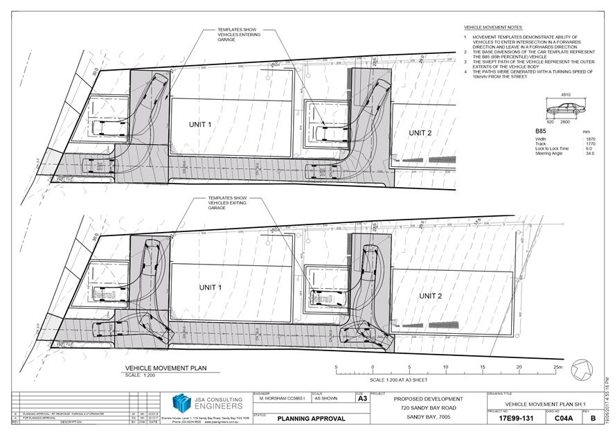
Prior to first occupation or commencement of use (whichever occurs first), vehicular barriers compliant with the Australian Standard AS/NZS1170.1:2002 must be installed to prevent vehicles running off the edge of an access driveway or parking module (parking spaces, aisles and manoeuvring area) where the drop from the edge of the trafficable area to a lower level is 600mm or greater, and wheel stops (kerb) must be installed for drops between 150mm and 600mm. Barriers must not limit the width of the driveway access or parking and turning areas approved under the permit.
Advice: The Council does not consider a slope greater than 1 in 4 to constitute a lower level as described in AS/NZS 2890.1:2004 Section 2.4.5.3. Slopes greater than 1 in 4 will require a vehicular barrier or wheel stop.
Designers are advised to consult the National Construction Code 2016 to determine if pedestrian handrails or safety barriers compliant with the NCC2016 are also required in the parking module this area may be considered as a path of access to a building.
Reason for condition
To ensure the safety of users of the access driveway and parking module and compliance with the standard.
ENG 2b
Prior to the issue of any approval under the Building Act 2016 or the commencement of works on site (whichever occurs first), a certified vehicle barrier design (including site plan with proposed location(s) of installation) prepared by a suitably qualified engineer, compliant with Australian Standard AS/NZS1170.1:2002, must be submitted to the Council. Advice: If the development's building approval includes the need for a Building Permit from Council, the applicant is advised to submit detailed design of vehicular barrier as part of the Building Application.
If the development's building approval is covered under Notifiable Work the applicant is advised to submit detailed design of vehicular barrier as a condition endorsement of the planning permit condition. Once the certification has been accepted, the Council will issue a condition endorsement (see general advice on how to obtain condition endorsement).
Reason for condition
To ensure the safety of users of the access driveway and parking module and compliance with the standard.
ENG 2c
Prior to the first occupation, vehicular barriers must be inspected by a qualified engineer and certification submitted to the Council confirming that the installed vehicular barriers comply with the certified design and Australian Standard AS/NZS1170.1:2002.
Advice: Certification may be submitted to the Council as part of the Building Act 2016 approval process or via condition endorsement (see general advice on how to obtain condition endorsement).
Reason for condition
To ensure the safety of users of the access driveway and parking module and compliance with the relevant standards.
ENG 3c
The access, driveway and parking module (parking spaces, aisles and manoeuvring area) must be designed and constructed in accordance with Australian Standard AS/NZS2890.1:2004 (including the requirement for vehicle safety barriers where required).
Prior to the first occupation, documentation by a suitably qualified engineer certifying that the access driveway and parking module has been constructed in accordance with AS2/NZS2890.1 must be lodged with the Council.
Advice: Certification may be submitted to the Council as part of the Building Act 2016 approval process or via condition endorsement (see general advice on how to obtain condition endorsement).
Reason for condition
To ensure the safety of users of the access and parking module, and compliance with the relevant Australian Standard.
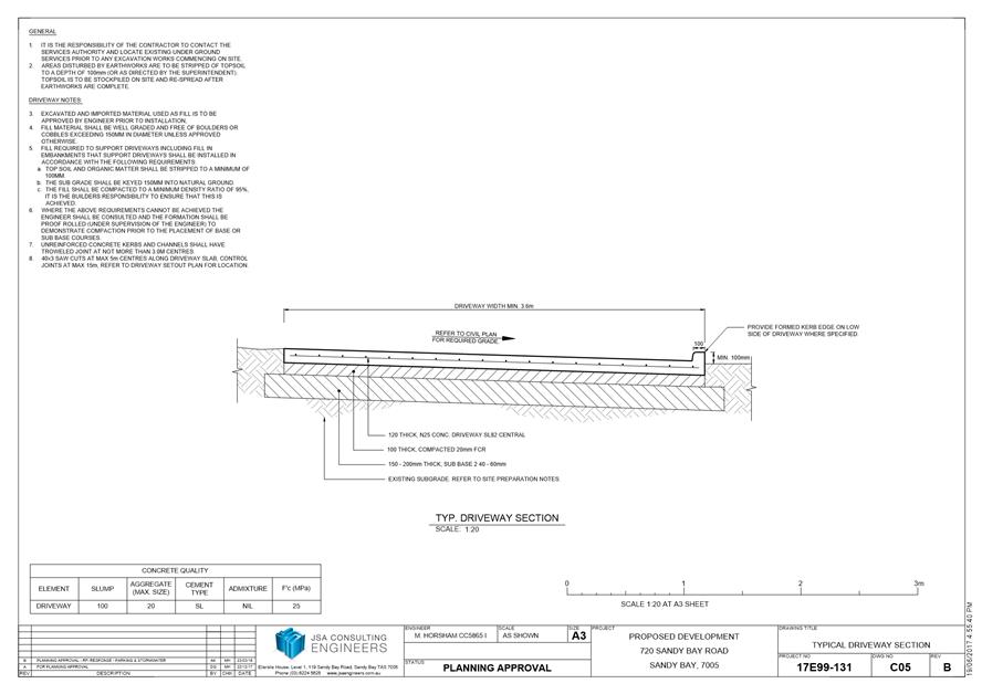
ENG 4
The access driveway and parking module (car parking spaces, aisles and manoeuvring area) approved by this permit must be constructed to a sealed standard (spray seal, asphalt, concrete, pavers or equivalent Council approved) and surface drained to the Council's stormwater infrastructure prior to the first occupation.
Reason for condition
To ensure the safety of users of the access driveway and parking module, and that it does not detract from the amenity of users, adjoining occupiers or the environment by preventing dust, mud and sediment transport.
ENG 5
The number of car parking spaces approved on the site is four (4).
No visitor parking is approved on site, and the turning areas are required to be kept clear from parked cars at all times to ensure vehicles are able to exit the property in a forward direction.
Reason for condition
To ensure the provision of parking for the use is safe and efficient.
ENG 1
The cost of repair of any damage to the Council's infrastructure resulting from the implementation of this permit, must be met by the owners within 30 days of the completion of the development or as otherwise determined by the Council.
A photographic record of the Council's infrastructure adjacent to the subject site must be provided to the Council prior to any commencement of works.
A photographic record of the Council’s infrastructure (e.g. existing property service connection points, roads, buildings, stormwater, footpaths, driveway crossovers and nature strips, including if any, preexisting damage) will be relied upon to establish the extent of damage caused to the Council’s infrastructure during construction. In the event that the owner/developer fails to provide to the Council a photographic record of the Council’s infrastructure, then any damage to the Council's infrastructure found on completion of works will be deemed to be the responsibility of the owner.
Reason for condition
To ensure that any of the Council's infrastructure and/or siterelated service connections affected by the proposal will be altered and/or reinstated at the owner’s full cost.
ENG 13
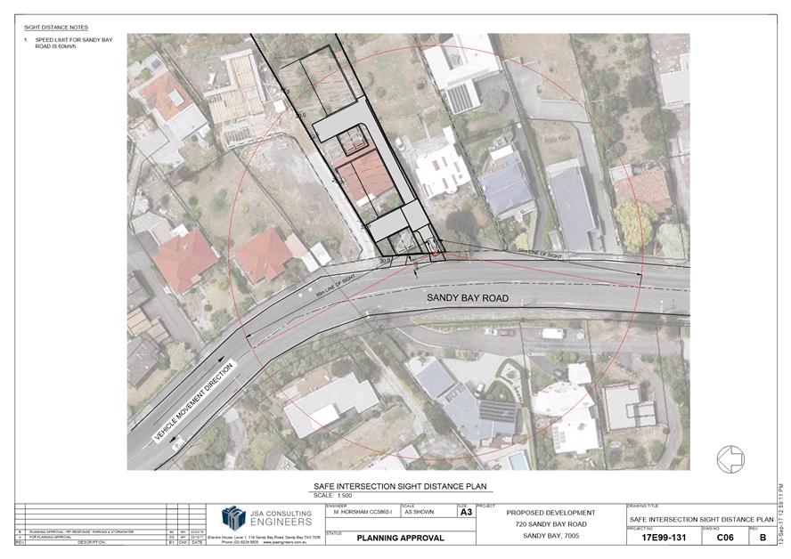
The front fencing/wall and gate at 720 Sandy Bay Road must allow adequate sight distance between user vehicles, cyclists and pedestrians.
Amended drawings must be submitted and approved, prior to the commencement of work. The amended drawings must demonstrate how the fence either side of the driveway provides for adequate sight distance between user vehicles, cyclists and pedestrians by one of the following methods:
1. Compliance with Australian/NZ Standard, Parking facilities Part 1: Offstreet car parking AS/NZS 2890.1: 2004 Fig 3.3; or 2. Increasing the gate opening width to 5m; or 3. Increasing the transparency of fencing/gate/wall for at least 1m on each side of driveway so that those sections of fencing are at least 50% transparent; or 4. Setting gates/fence/wall back 1m from the front property boundary for at least 1m on each side of the driveway.
All work required by this condition must be undertaken in accordance with the approved drawings.
Advice: Once the amended drawing has been approved the Council will issue a condition endorsement (see general advice on how to obtain condition endorsement).
Where building approval is also required, it is recommended that documentation for condition endorsement be submitted well before submitting documentation for building approval. Failure to address condition endorsement requirements prior to submitting for building approval may result in unexpected delays.
Reason for condition
To ensure the safety of vehicles entering and leaving the development and of pedestrians and traffic in the vicinity.
ENGR 3
Prior to the commencement of use, the redundant driveway crossover in the Sandy Bay Road highway reservation must be reinstated.
Prior to the commencement of use, the proposed driveway crossover in the Sandy Bay Road highway reservation must be designed and constructed generally in accordance with:
1. Urban TSDR09v1 – Urban Roads Driveways and TSD R17v1 Plinth and Grate vehicular crossing; and 2. Footpath Urban Roads Footpaths TSDR11v1.
Advice: You will require a Permit to Open Up and Temporarily Occupy a Highway (for work in the road reserve). Click here for more information.
Reason for condition
To ensure crossovers match surrounding crossovers and provide a safe environment for users of the adjacent cycle path.
ENG s1
The proposed sliding gate must not encroach onto the Sandy Bay Road Highway Reservation.
Reason for condition
To ensure that safety of pedestrians on the Council’s highway reservation is not compromised by the development.
ENV 2
Sediment and erosion control measures, in accordance with an approved soil and water management plan (SWMP), must be installed prior to the commencement of work and maintained until such time as all disturbed areas have been stabilised and/or restored or sealed to the Council’s satisfaction.
A SWMP must be submitted prior to the issue of any approval under the Building Act 2016 or the commencement of work, whichever occurs first. The SWMP must be prepared in accordance with the Soil and Water Management on Building and Construction Sites fact sheets (Derwent Estuary Program, 2008), available here.
All work required by this condition must be undertaken in accordance with the approved SWMP.
Advice: Once the SWMP has been approved, the Council will issue a condition endorsement (see general advice on how to obtain condition endorsement).
Where building approval is also required, it is recommended that documentation for condition endorsement be submitted well before submitting documentation for building approval. Failure to address condition endorsement requirements prior to submitting for building approval may result in unexpected delays.
Reason for condition
To avoid the pollution and sedimentation of roads, drains and natural watercourses that could be caused by erosion and runoff from the development.
ADVICE
The following advice is provided to you to assist in the implementation of the planning permit that has been issued subject to the conditions above. The advice is not exhaustive and you must inform yourself of any other legislation, bylaws, regulations, codes or standards that will apply to your development under which you may need to obtain an approval. Visit the Council's website for further information.
Prior to any commencement of work on the site or commencement of use the following additional permits/approval may be required from the Hobart City Council.
CONDITION ENDORSEMENT ENGINEERING
All engineering drawings required to be submitted and approved by this planning permit must be submitted to the City of Hobart as a CEP (Condition Endorsement) via the City’s Online Service Development Portal. When lodging a CEP, please reference the PLN number of the associated Planning Application. Each CEP must also include an estimation of the cost of works shown on the submitted engineering drawings. Once that estimation has been confirmed by the City’s Engineer, the following fees are payable for each CEP submitted and must be paid prior to the City of Hobart commencing assessment of the engineering drawings in each CEP:
Value of Building Works Approved by Planning Permit Fee:
Up to $20,000: $150 per application. Over $20,000: 2% of the value of the works as assessed by the City's Engineer per assessment.
These fees are additional to building and plumbing fees charged under the Building and Plumbing Regulations.
Once the CEP is lodged via the Online Service Development Portal, if the value of building works approved by your planning permit is over $20,000, please contact the City’s Development Engineer on 6238 2715 to confirm the estimation of the cost of works shown on the submitted engineering drawings has been accepted.
Once confirmed, pleased call one of the City’s Customer Service Officers on 6238 2190 to make payment, quoting the reference number (ie. CEP number) of the Condition Endorsement you have lodged. Once payment is made, your engineering drawings will be assessed.
BUILDING PERMIT
You may need building approval in accordance with the Building Act 2016. Click here for more information.
This is a Discretionary Planning Permit issued in accordance with section 57 of the Land Use Planning and Approvals Act 1993.
PLUMBING PERMIT
You may need plumbing approval in accordance with the Building Act 2016, Building Regulations 2016 and the National Construction Code. Click here for more information.
OCCUPATION OF THE PUBLIC HIGHWAY
You may require a Permit to Open Up and Temporarily Occupy a Highway (for work in the road reserve). Click here for more information.
NEW SERVICE CONNECTION
Please contact the Hobart City Council's City Infrastructure Division to initiate the application process for your new service connection.
STORM WATER
Please note that in addition to a building and/or plumbing permit, development must be in accordance with the Hobart City Council’s Hydraulic Services By law. Click here for more information.
WORK WITHIN THE HIGHWAY RESERVATION
Please note development must be in accordance with the Hobart City Council’s Highways By law. Click here for more information.
REDUNDANT CROSSOVERS
Redundant crossovers are required to be reinstated under the Hobart City Council’s Highways By law. Click here for more information.
ACCESS
Designed in accordance with LGAT IPWEA – Tasmanian standard drawings. Click here for more information.
CROSS OVER CONSTRUCTION
The construction of the crossover can be undertaken by the Council or by a private contractor, subject to Council approval of the design. Click here for more information.
Services to be designed and constructed in accordance with the (IPWEA) LGAT –standard drawings. Click here for more information.
WEED CONTROL
Effective measures are detailed in the Tasmanian Washdown Guidelines for Weed and Disease Control: Machinery, Vehicles and Equipment (Edition 1, 2004). The guidelines can be obtained from the Department of Primary Industries, Parks, Water and Environment website.
WASTE DISPOSAL
It is recommended that the developer liaise with the Council’s Cleansing and Solid Waste Unit regarding reducing, reusing and recycling materials associated with demolition on the site to minimise solid waste being directed to landfill.
Further information regarding waste disposal can also be found on the Council’s website.
FEES AND CHARGES
Click here for information on the Council's fees and charges.
DIAL BEFORE YOU DIG
Click here for dial before you dig information.
|
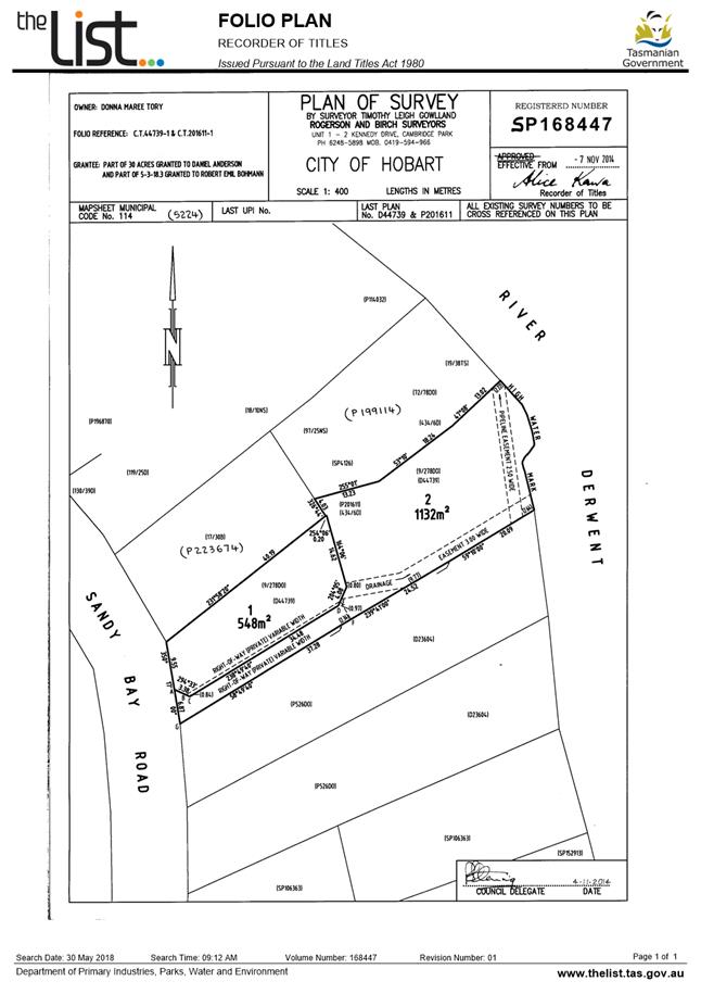
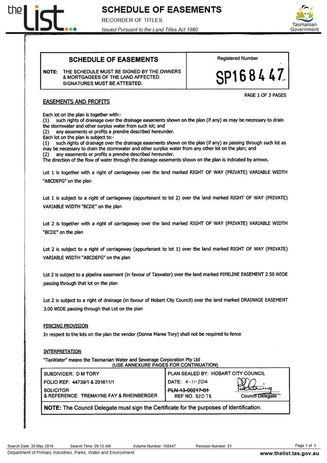
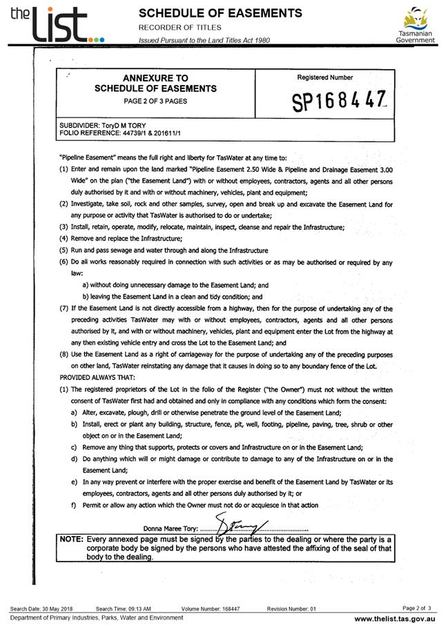
Attachment a: PLN-17-1069
- 720 SANDY BAY ROAD SANDY BAY TAS 7005 - Planning Committee or Delegated
Report ⇩ ![]()
Attachment
b: PLN-17-1069
- 720 SANDY BAY ROAD SANDY BAY TAS 7005 - CPC Agenda Documents ⇩ ![]()
Attachment
c: PLN-17-1069
- 720 SANDY BAY ROAD SANDY BAY TAS 7005 - Potential Alternative Cladding ⇩ ![]()
|
Item No. 7.1.1 |
Agenda (Open Portion) City Planning Committee Meeting - 27/8/2018 |
Page 21 ATTACHMENT a |

|
Agenda (Open Portion) City Planning Committee Meeting - 27/8/2018 |
Page 56 ATTACHMENT b |
|
Item No. 7.1.1 |
Agenda (Open Portion) City Planning Committee Meeting - 27/8/2018 |
Page 57 ATTACHMENT b |
|
Item No. 7.1.1 |
Agenda (Open Portion) City Planning Committee Meeting - 27/8/2018 |
Page 90 ATTACHMENT b |

|
Item No. 7.1.1 |
Agenda (Open Portion) City Planning Committee Meeting - 27/8/2018 |
Page 97 ATTACHMENT b |
|
Item No. 7.1.1 |
Agenda (Open Portion) City Planning Committee Meeting - 27/8/2018 |
Page 112 ATTACHMENT b |
|
Item No. 7.1.1 |
Agenda (Open Portion) City Planning Committee Meeting - 27/8/2018 |
Page 119 ATTACHMENT c |

|
Agenda (Open Portion) City Planning Committee Meeting |
Page 123 |
|
|
|
27/8/2018 |
|
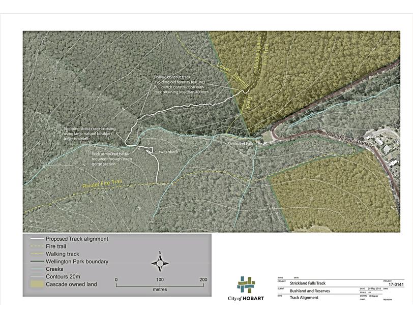
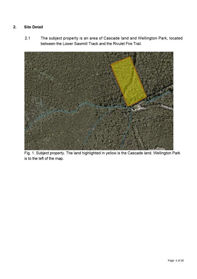
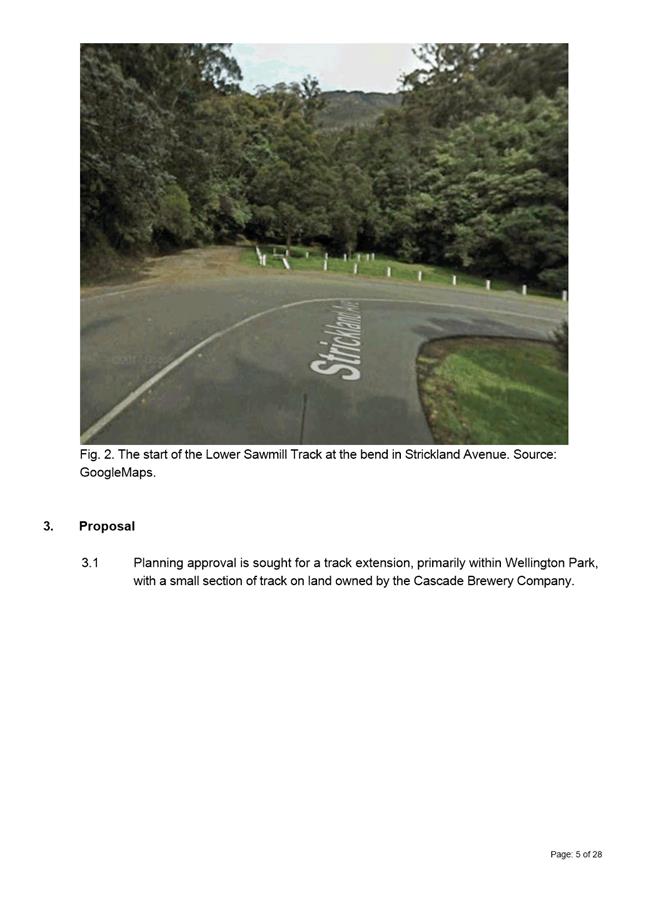
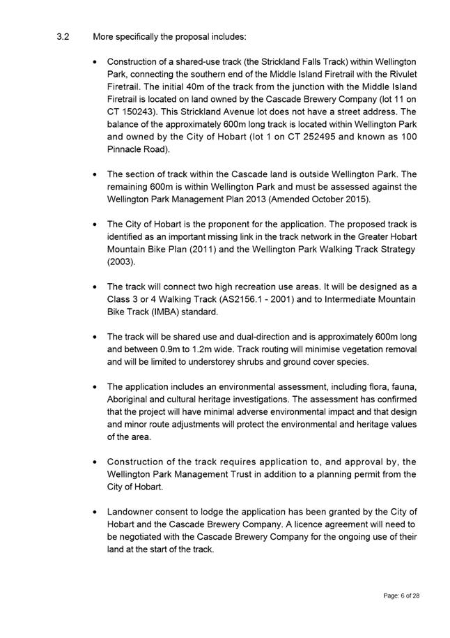
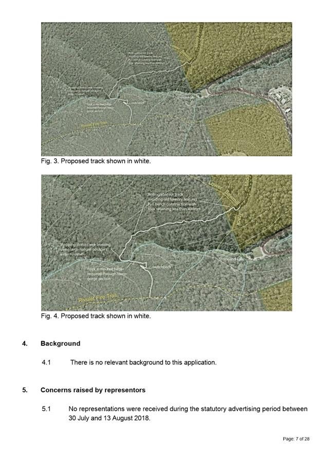
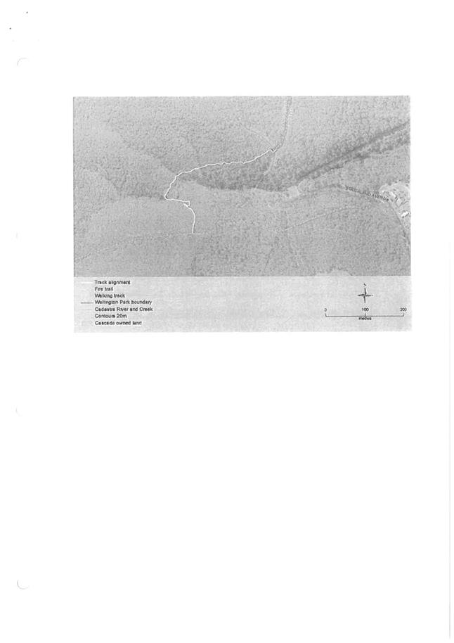
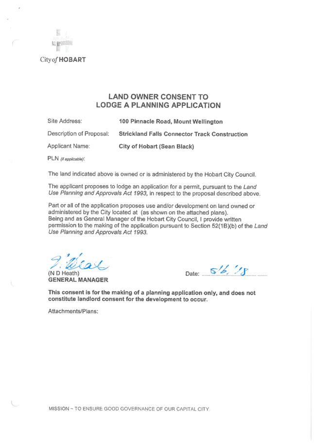
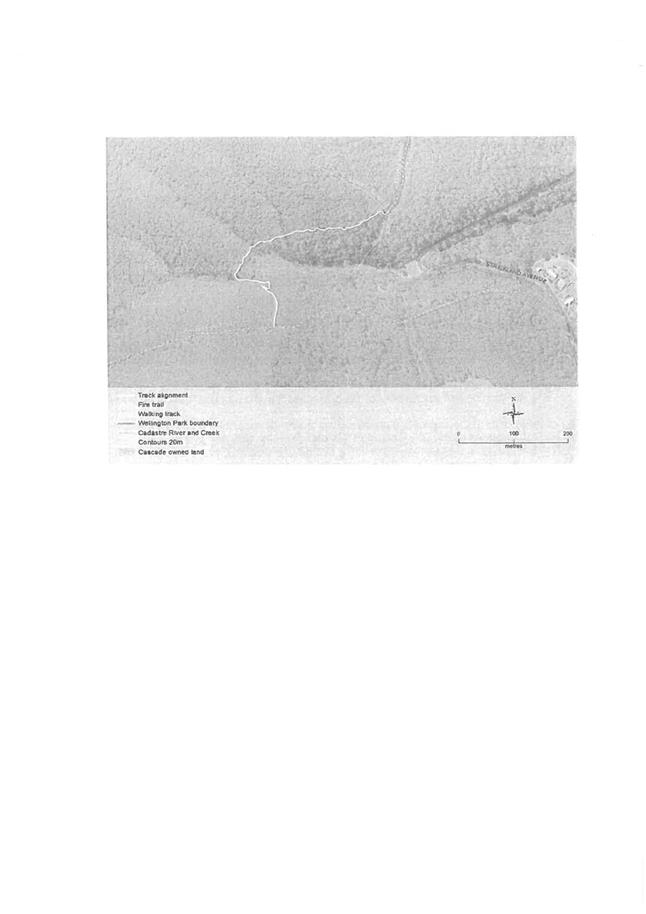
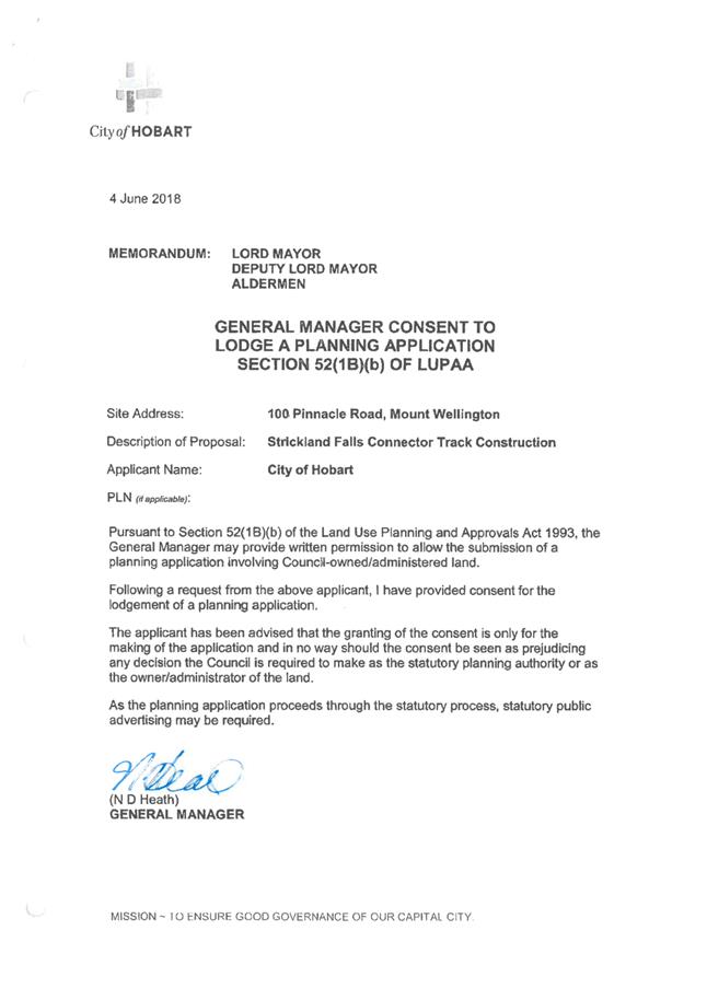
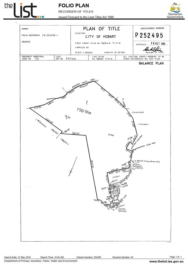
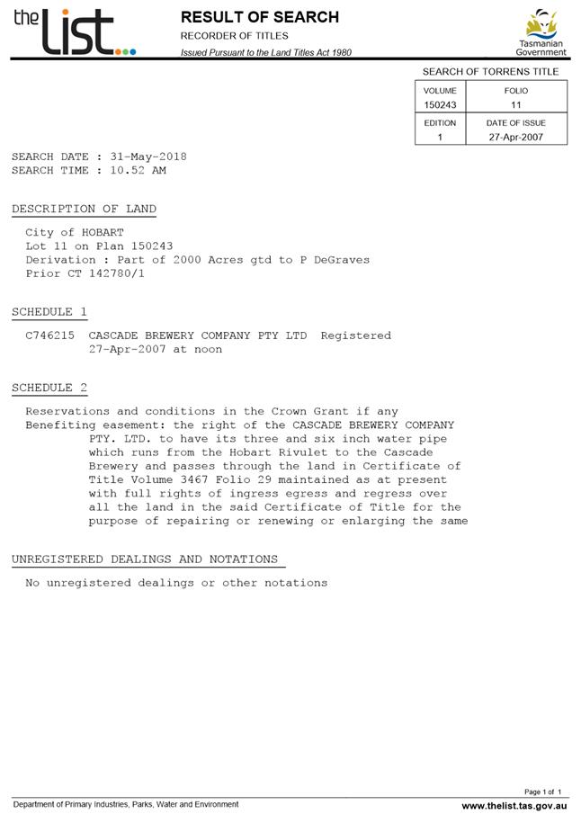
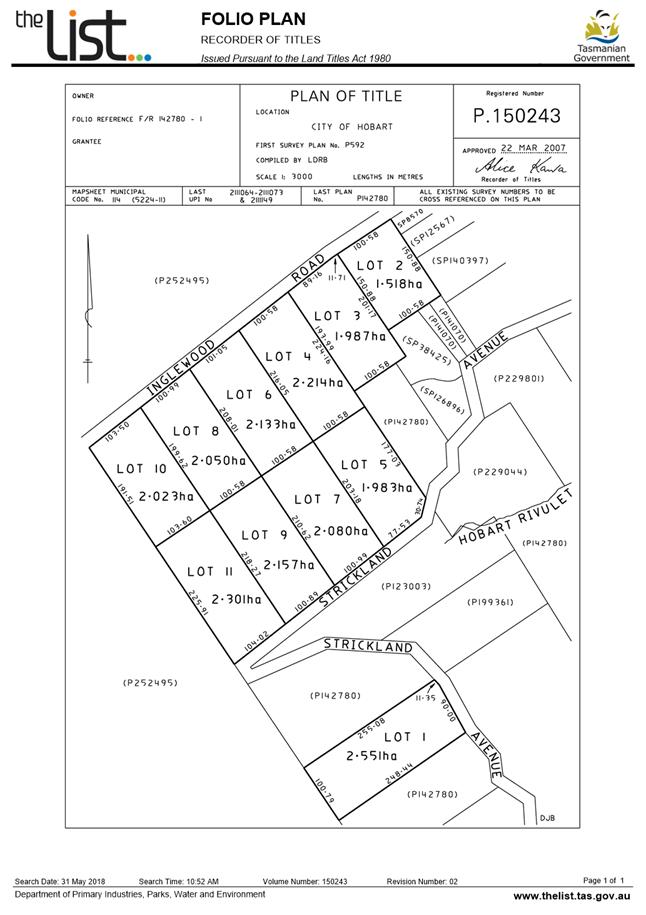
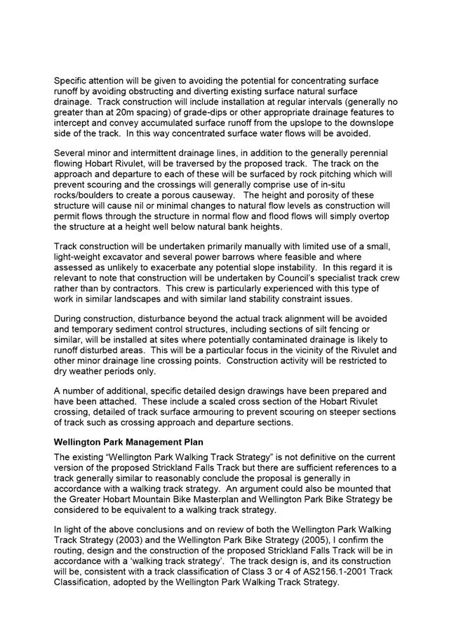
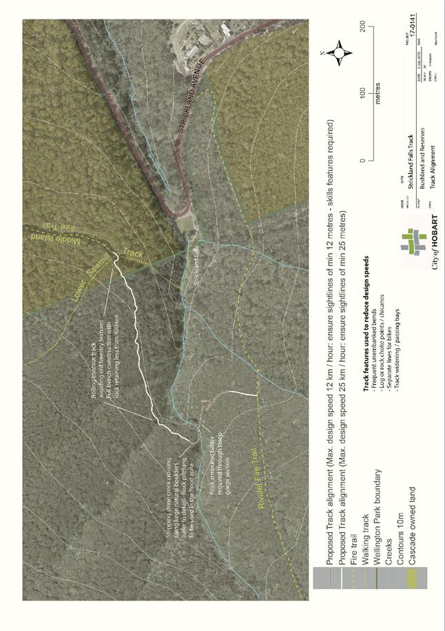
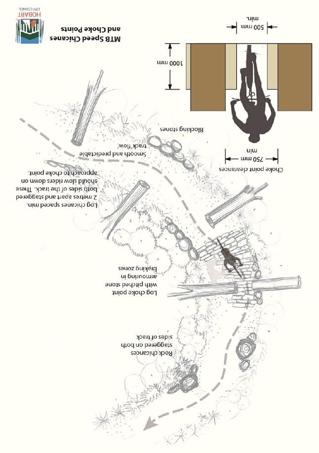
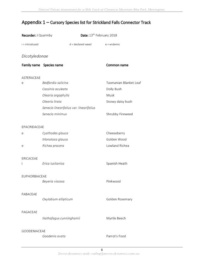
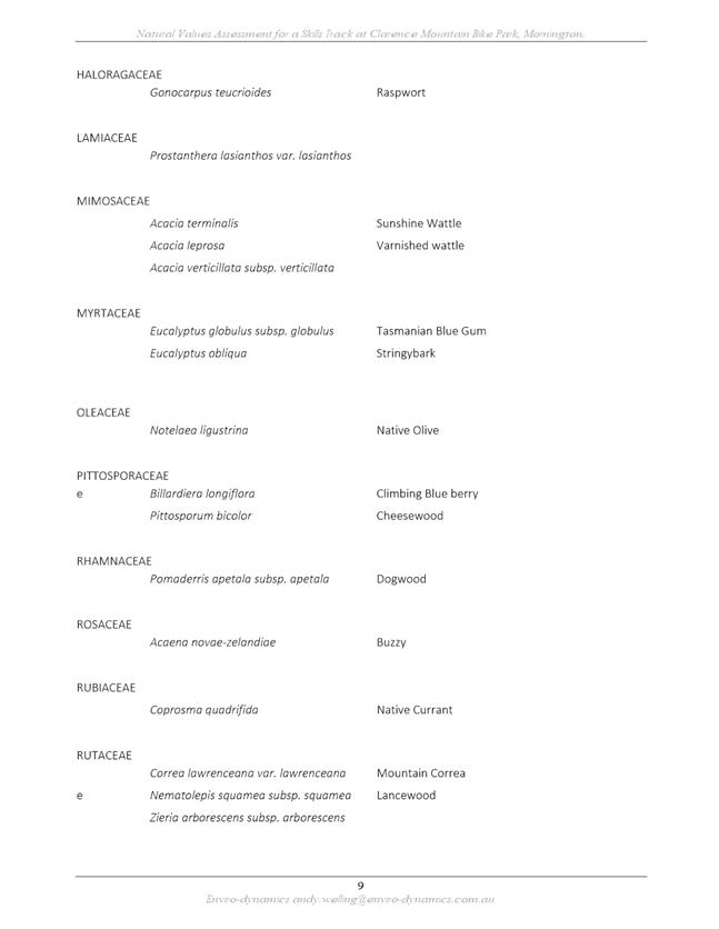
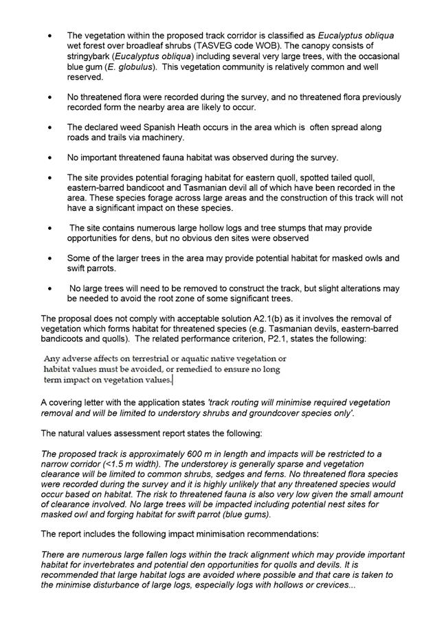
7.1.2 100 Pinnacle Road, Mount Wellington and CT 150243/11 Strickland Avenue, South Hobart - Track Extension
Address: 100 Pinnacle Road, Mount Wellington and CT 150243/11 Strickland Avenue, South Hobart
Proposal: Track Extension
Expiry Date: 18 September 2018
Extension of Time: Not applicable
Author: Liz Wilson
|
REcommendation That: Pursuant to the Hobart Interim Planning Scheme 2015, the Council approve the application for track extension at 100 Pinnacle Road MOUNT WELLINGTON and CT 150243/11 Strickland Avenue SOUTH HOBART for the reasons outlined in the officer’s report and a permit containing the following conditions be issued:
GEN
The use and/or development must be substantially in accordance with the documents and drawings that comprise PLN18364 100 PINNACLE ROAD MOUNT WELLINGTON & CT 150243/11 STRICKLAND AVENUE SOUTH HOBART TAS 7054 except where modified below.
Reason for condition
To clarify the scope of the permit.
ENG 1
The cost of repair of any damage to the Council's infrastructure resulting from the implementation of this permit, must be met by the owners within 30 days of the completion of the development or as otherwise determined by the Council.
A photographic record of the Council's infrastructure adjacent to the subject site must be provided to the Council prior to any commencement of works.
A photographic record of the Council’s infrastructure (e.g. existing property service connection points, roads, buildings, stormwater, footpaths, driveway crossovers and nature strips, including if any, preexisting damage) will be relied upon to establish the extent of damage caused to the Council’s infrastructure during construction. In the event that the owner/developer fails to provide to the Council a photographic record of the Council’s infrastructure, then any damage to the Council's infrastructure found on completion of works will be deemed to be the responsibility of the owner.
Reason for condition
To ensure that any of the Council's infrastructure and/or siterelated service connections affected by the proposal will be altered and/or reinstated at the owner’s full cost.
ENG s1
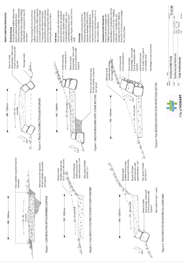
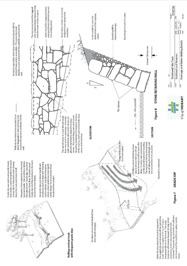
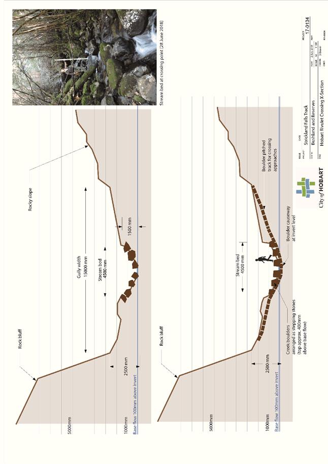
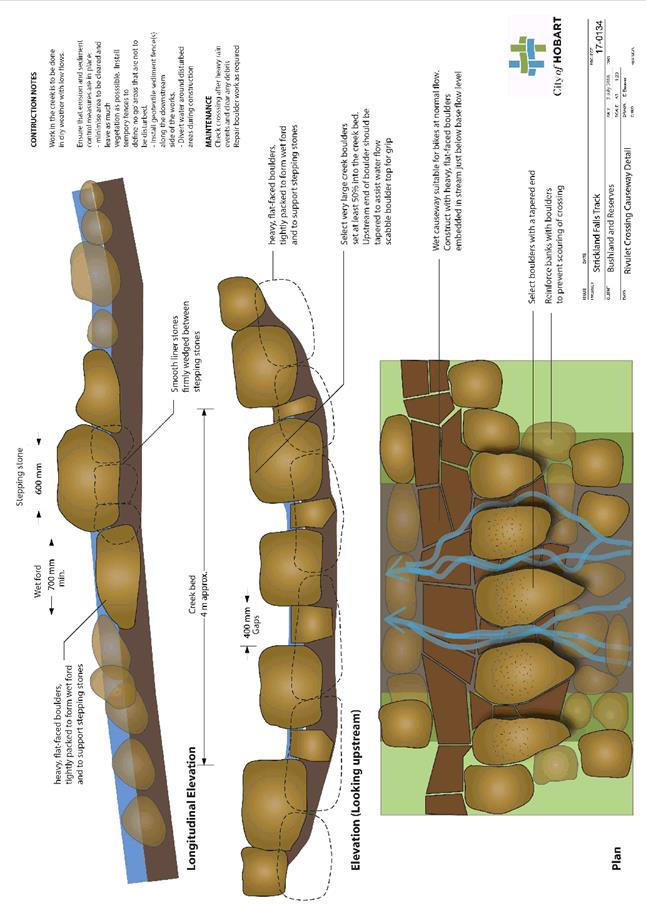
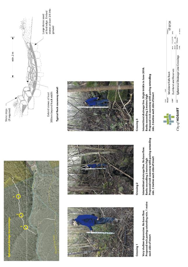
Tracks must be treated to prevent erosion and generation of sediment (e.g. rock armoured) for their full extent within the banks of the creeks or as shown in the submitted plans (whichever is greater).
Reason for condition
To prevent sedimentation of creeks
ENV 9
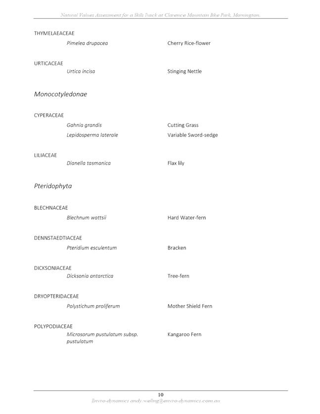
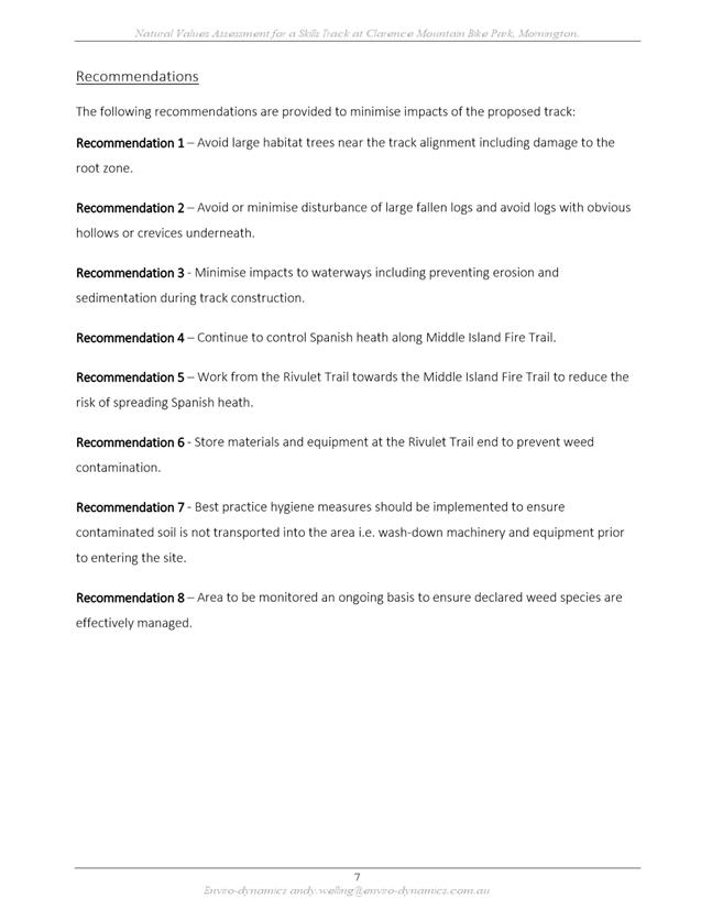
The recommendations of the Natural Values Assessment by EnviroDynamics dated May 2018 must be implemented including:
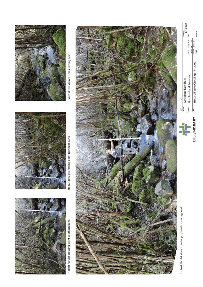
1. Large habitat trees, including likely root zones, must be avoided as far as reasonably practicable. 2. Large fallen logs and logs with obvious hollows or crevices underneath must be avoided as far as reasonably practicable. 3. Works must progress from the Rivulet Trail towards the Middle Island Fire Trail to reduce the risk of spreading weeds. 4. Materials and equipment must be stored at the Rivulet Trail end of the track to minimise the risk of weed spread.
Reason for condition
To ensure impacts upon vegetation and habitat are minimised.
ENV 12
An approved weed management plan for the eradication of Spanish heath along Middle Island Fire Trail must be implemented.
A weed management plan prepared by a suitably qualified and experienced person must be submitted and approved, prior to the commencement of work.
All work required by this condition must be undertaken in accordance with the approved weed management plan.
Advice: Once the weed management plan has been approved the Council will issue a condition endorsement (see general advice on how to obtain condition endorsement).
Reason for condition
To ensure remaining moderate priority biodiversity values are retained and improved, and to ensure impacts upon vegetation and habitat are minimised.
ENV 15
An approved construction hygiene protocol to minimise the risk of introduction and spread of weeds must be implemented.
A construction hygiene protocol prepared by a suitably qualified and experienced person must be submitted and approved, prior to the commencement of work.
All work required by this condition must be undertaken in accordance with the approved construction hygiene protocol.
Advice: Once the weed management plan has been approved the Council will issue a condition endorsement (see general advice on how to obtain condition endorsement).
Reason for condition
To ensure impacts upon vegetation and habitat are minimised.
ENV 2
Sediment and erosion control measures, in accordance with an approved soil and water management plan (SWMP), must be installed prior to the commencement of work and maintained until such time as all disturbed areas have been stabilised and/or restored or sealed to the Council’s satisfaction.
A SWMP must be submitted prior to the issue of any approval under the Building Act 2016 or the commencement of work, whichever occurs first. The SWMP must be prepared in accordance with the Soil and Water Management on Building and Construction Sites fact sheets (Derwent Estuary Program, 2008), available here.
All work required by this condition must be undertaken in accordance with the approved SWMP.
Advice: Once the SWMP has been approved, the Council will issue a condition endorsement (see general advice on how to obtain condition endorsement).
Where building approval is also required, it is recommended that documentation for condition endorsement be submitted well before submitting documentation for building approval. Failure to address condition endorsement requirements prior to submitting for building approval may result in unexpected delays.
Reason for condition
To avoid the pollution and sedimentation of roads, drains and natural watercourses that could be caused by erosion and runoff from the development.
HER 6
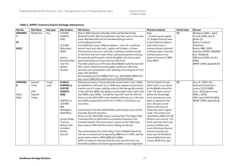
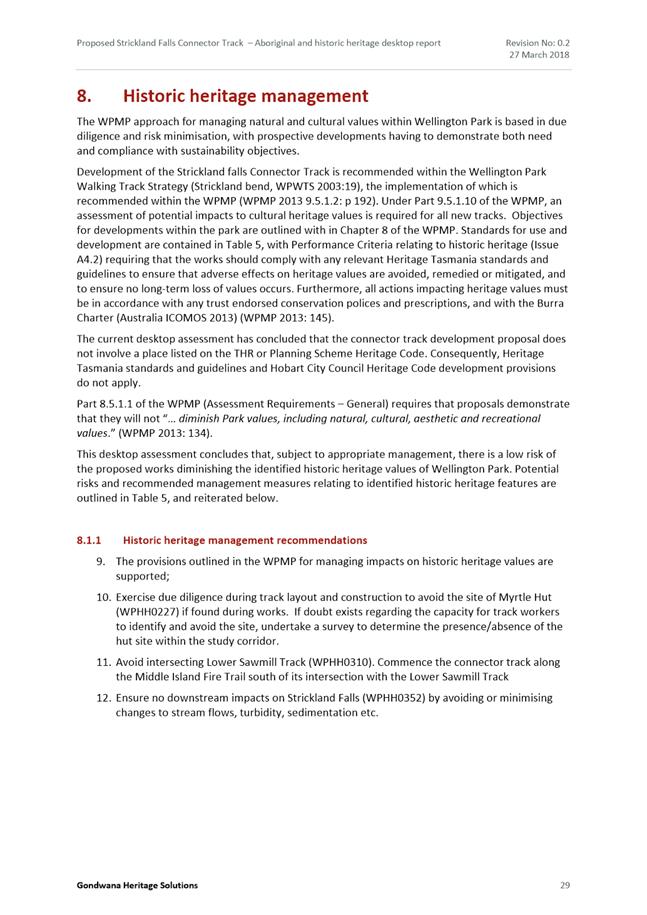
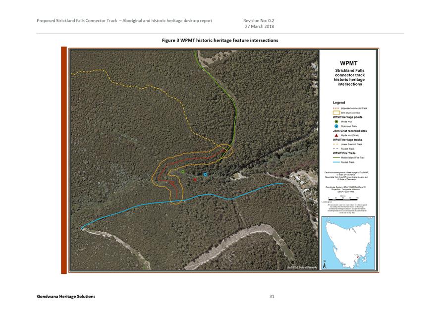
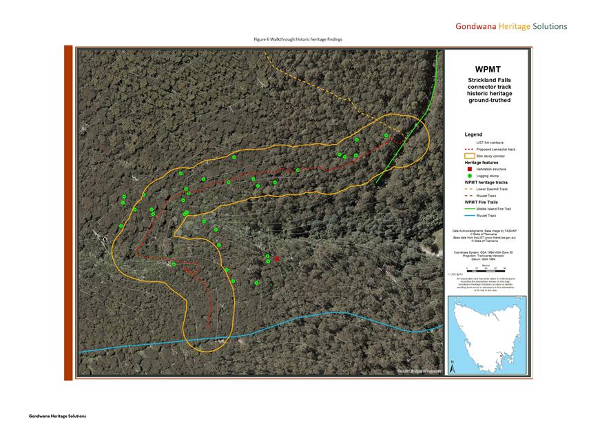
The recommendations outlined in section 5.2.1 of report by Gondwana Heritage Solutions titled Proposed Strickland Falls Connector Track, kunanyi/Mt Wellington, Aboriginal and Historic Heritage Desktop Report dated March 2017 must be implemented.
Reason for condition
To ensure that any impacts on sites of Aboriginal value are avoided, mitigated or remedied so that no long term loss of Aboriginal cultural heritage values occurs, in accordance with the Wellington Park Management Plan 2013.
ADVICE
The following advice is provided to you to assist in the implementation of the planning permit that has been issued subject to the conditions above. The advice is not exhaustive and you must inform yourself of any other legislation, bylaws, regulations, codes or standards that will apply to your development under which you may need to obtain an approval. Visit the Council's website for further information.
Prior to any commencement of work on the site or commencement of use the following additional permits/approval may be required from the Hobart City Council.
CONDITION ENDORSEMENT PLANNING
As a condition endorsement is required by a planning condition above, you will need to submit the relevant documentation to satisfy the condition via the Condition Endorsement Submission on Council's online services eplanning
Where building approval is also required, it is recommended that documentation for condition endorsement be submitted well before submitting documentation for building approval. Failure to address condition endorsement requirements prior to submitting for building approval may result in unexpected delays.
Once approved, the Council will respond to you via email that the condition has been endorsed (satisfied). Detailed instructions can be found here.
BUILDING PERMIT
You may need building approval in accordance with the Building Act 2016. Click here for more information.
This is a Discretionary Planning Permit issued in accordance with section 57 of the Land Use Planning and Approvals Act 1993.
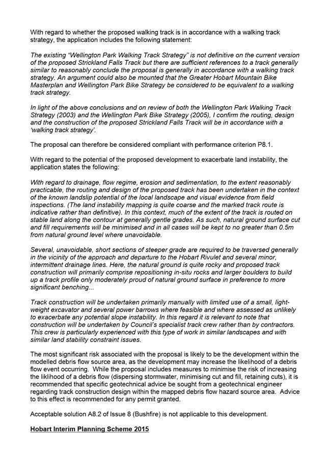
LANDSLIDE RISK
It is recommended that the track design within the Medium Landslide Hazard Area identified in the Landslide Code of the Hobart Interim Planning Scheme 2015 (debris flow source area) is endorsed by a suitably qualified geotechnical engineer to ensure the works do not increase the likelihood of landslide.
|
Attachment a: PLN-18-364
- 100 PINNACLE ROAD MOUNT WELLINGTON TAS 7054 - Planning Committee or Delegated
Report ⇩ ![]()
Attachment
b: PLN-18-364
- 100 PINNACLE ROAD MOUNT WELLINGTON & CT 150243 11 STRICKLAND AVENUE SOUTH
HOBART TAS 7054 - CPC Agenda Documents ⇩ ![]()
Attachment
c: PLN-18-364
- 100 PINNACLE ROAD MOUNT WELLINGTON & CT 150243/11 STRICKLAND AVENUE SOUTH
HOBART TAS 7054 - Referral Officer Reports (Environmental Development Planner
and Senior Cultural Heritage Officer) ⇩ ![]()
|
Item No. 7.1.2 |
Agenda (Open Portion) City Planning Committee Meeting - 27/8/2018 |
Page 129 ATTACHMENT a |
|
Agenda (Open Portion) City Planning Committee Meeting - 27/8/2018 |
Page 157 ATTACHMENT b |
|
Item No. 7.1.2 |
Agenda (Open Portion) City Planning Committee Meeting - 27/8/2018 |
Page 170 ATTACHMENT b |
|
Item No. 7.1.2 |
Agenda (Open Portion) City Planning Committee Meeting - 27/8/2018 |
Page 171 ATTACHMENT b |


|
Item No. 7.1.2 |
Agenda (Open Portion) City Planning Committee Meeting - 27/8/2018 |
Page 208 ATTACHMENT b |
|
Item No. 7.1.2 |
Agenda (Open Portion) City Planning Committee Meeting - 27/8/2018 |
Page 211 ATTACHMENT b |
|
Item No. 7.1.2 |
Agenda (Open Portion) City Planning Committee Meeting - 27/8/2018 |
Page 213 ATTACHMENT b |
|
Item No. 7.1.2 |
Agenda (Open Portion) City Planning Committee Meeting - 27/8/2018 |
Page 216 ATTACHMENT b |
|
Item No. 7.1.2 |
Agenda (Open Portion) City Planning Committee Meeting - 27/8/2018 |
Page 225 ATTACHMENT b |
|
Item No. 7.1.2 |
Agenda (Open Portion) City Planning Committee Meeting - 27/8/2018 |
Page 228 ATTACHMENT b |
|
Item No. 7.1.2 |
Agenda (Open Portion) City Planning Committee Meeting - 27/8/2018 |
Page 240 ATTACHMENT c |
|
Agenda (Open Portion) City Planning Committee Meeting |
Page 250 |
|
|
|
27/8/2018 |
|
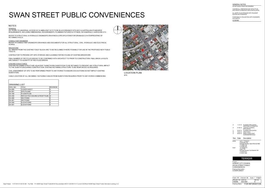
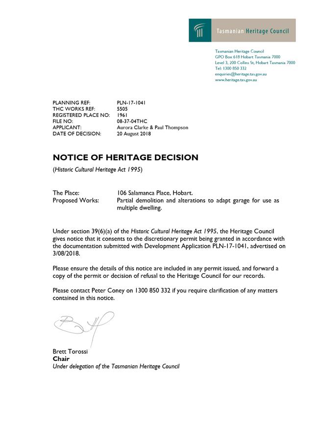
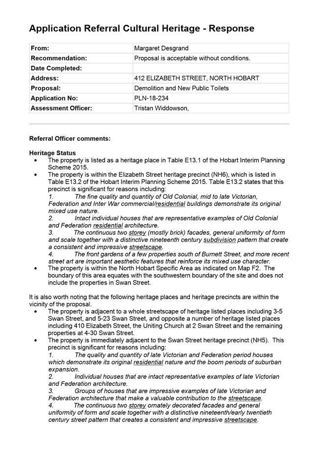
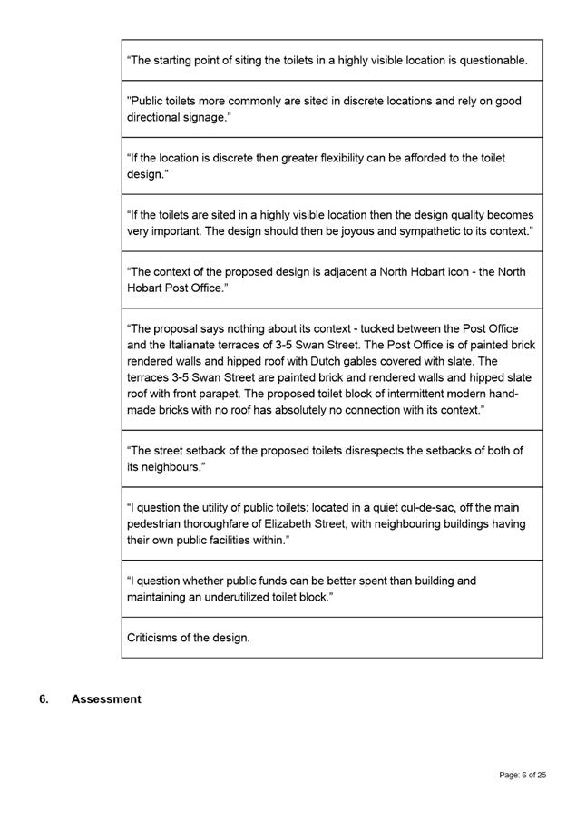
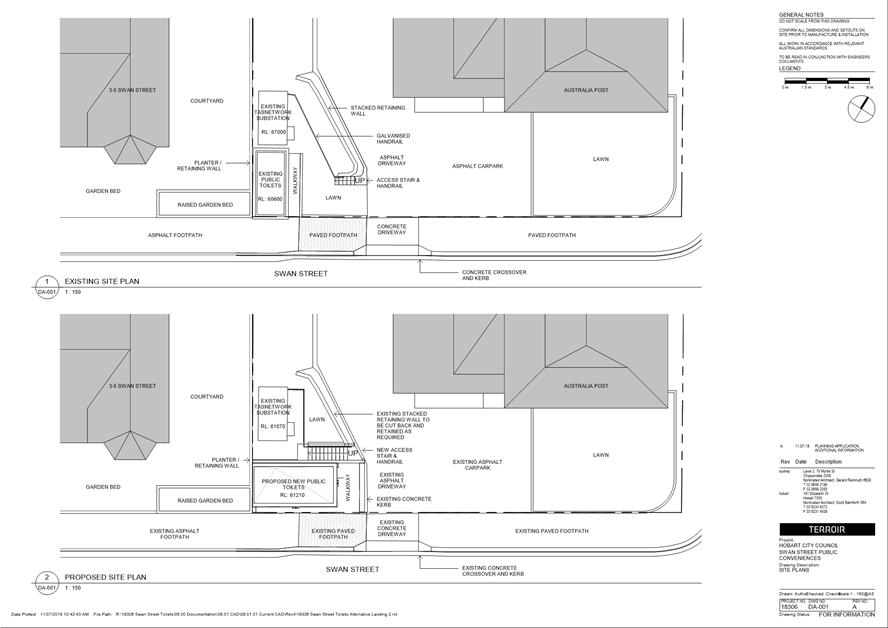
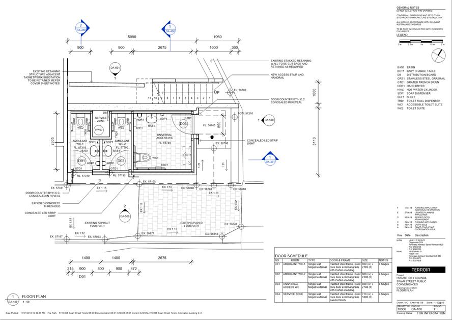
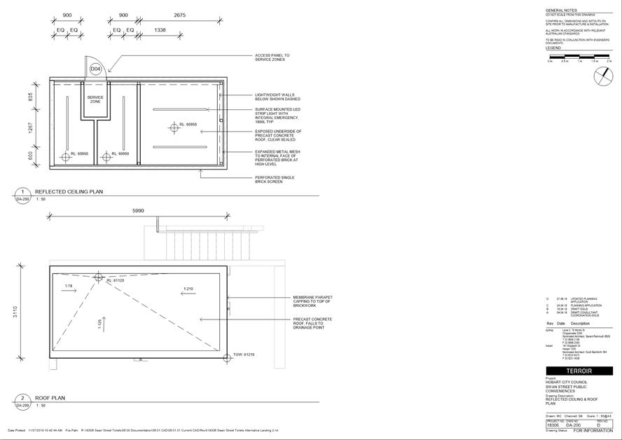
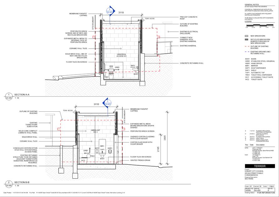
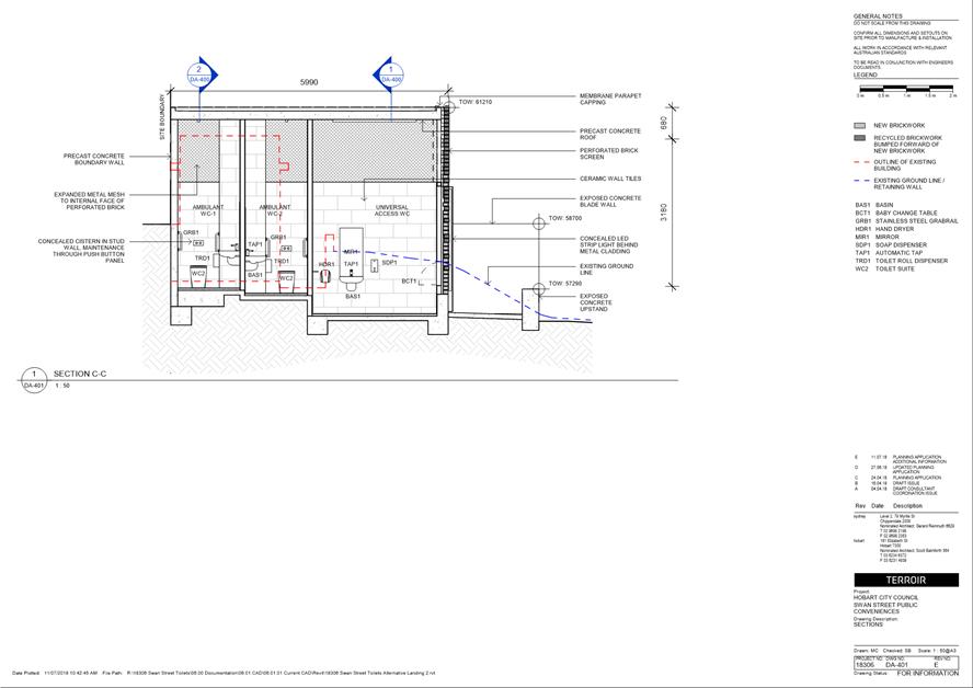
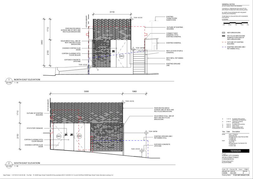
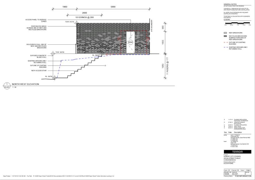
7.1.3 412 Elizabeth Street, North Hobart - Demolition and New Public Toilets
Address: 412 Elizabeth Street, North Hobart
Proposal: Demolition and New Public Toilets
Expiry Date: 20 September 2018
Extension of Time: Not applicable
Author: Tristan Widdowson
|
REcommendation That: Pursuant to the Hobart Interim Planning Scheme 2015, the Council approve the application for demolition and new public toilets at 412 Elizabeth Street, North Hobart for the reasons outlined in the officer’s report and a permit containing the following conditions be issued:
GEN
The use and/or development must be substantially in accordance with the documents and drawings that comprise PLN18234 412 ELIZABETH STREET NORTH HOBART TAS 7000 Final Planning Documents except where modified below.
Reason for condition
To clarify the scope of the permit.
ENG 1
The cost of repair of any damage to the Council's infrastructure resulting from the implementation of this permit, must be met by the owners within 30 days of the completion of the development or as otherwise determined by the Council.
A photographic record of the Council's infrastructure adjacent to the subject site must be provided to the Council prior to any commencement of works.
A photographic record of the Council’s infrastructure (e.g. existing property service connection points, roads, buildings, storm water, footpaths, driveway crossovers and nature strips, including if any, preexisting damage) will be relied upon to establish the extent of damage caused to the Council’s infrastructure during construction. In the event that the owner/developer fails to provide to the Council a photographic record of the Council’s infrastructure, then any damage to the Council's infrastructure found on completion of works will be deemed to be the responsibility of the owner.
Reason for condition
To ensure that any of the Council's infrastructure and/or site related service connections affected by the proposal will be altered and/or reinstated at the owner’s full cost.
ADVICE
The following advice is provided to you to assist in the implementation of the planning permit that has been issued subject to the conditions above. The advice is not exhaustive and you must inform yourself of any other legislation, bylaws, regulations, codes or standards that will apply to your development under which you may need to obtain an approval. Visit the Council's website for further information.
Prior to any commencement of work on the site or commencement of use the following additional permits/approval may be required from the Hobart City Council.
BUILDING PERMIT
You may need building approval in accordance with the Building Act 2016. Click here for more information.
This is a Discretionary Planning Permit issued in accordance with section 57 of the Land Use Planning and Approvals Act 1993.
PLUMBING PERMIT
You may need plumbing approval in accordance with the Building Act 2016, Building Regulations 2016 and the National Construction Code. Click here for more information.
OCCUPATION OF THE PUBLIC HIGHWAY
You may require a permit for the occupation of the public highway for construction or special event (e.g. placement of skip bin, crane, scissor lift etc). Click here for more information. .
|
Attachment a: PLN-18-234
- 412 ELIZABETH STREET NORTH HOBART TAS 7000 - Planning Committee or Delegated
Report ⇩ ![]()
Attachment
b: PLN-18-234
- 412 ELIZABETH STREET NORTH HOBART TAS 7000 - CPC Agenda Documents ⇩ ![]()
Attachment
c: PLN-18-234
- 412 ELIZABETH STREET NORTH HOBART TAS 7000 - CPC Supporting Documents -
Planning Referral Officer Cultural Heritage Report ⇩ ![]()
|
Item No. 7.1.3 |
Agenda (Open Portion) City Planning Committee Meeting - 27/8/2018 |
Page 253 ATTACHMENT a |
|
Agenda (Open Portion) City Planning Committee Meeting - 27/8/2018 |
Page 278 ATTACHMENT b |
|
Item No. 7.1.3 |
Agenda (Open Portion) City Planning Committee Meeting - 27/8/2018 |
Page 287 ATTACHMENT b |
|
Item No. 7.1.3 |
Agenda (Open Portion) City Planning Committee Meeting - 27/8/2018 |
Page 294 ATTACHMENT c |

|
Agenda (Open Portion) City Planning Committee Meeting |
Page 301 |
|
|
|
27/8/2018 |
|
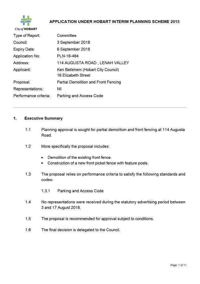
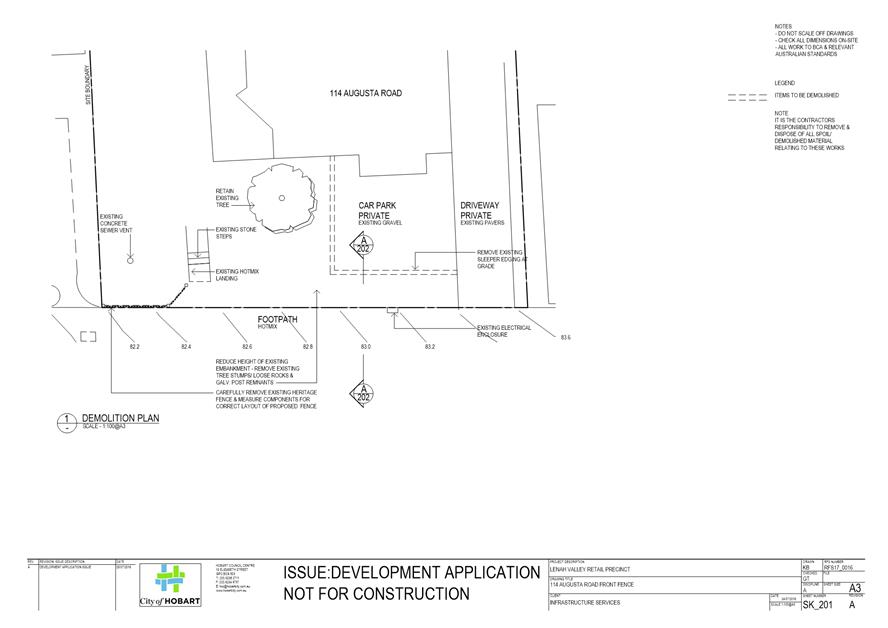
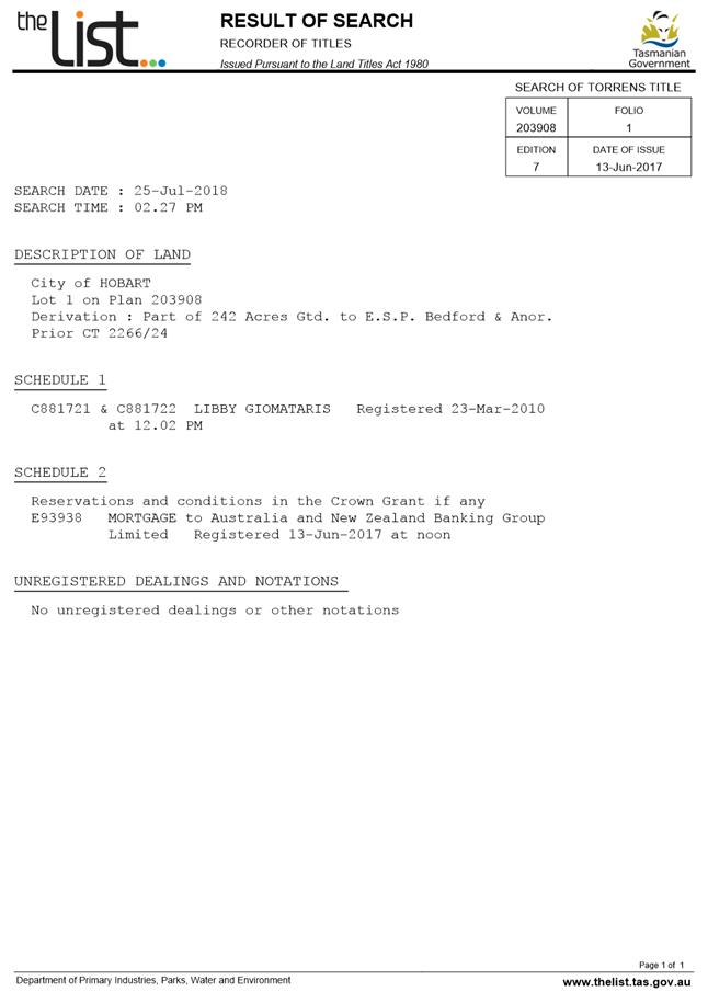
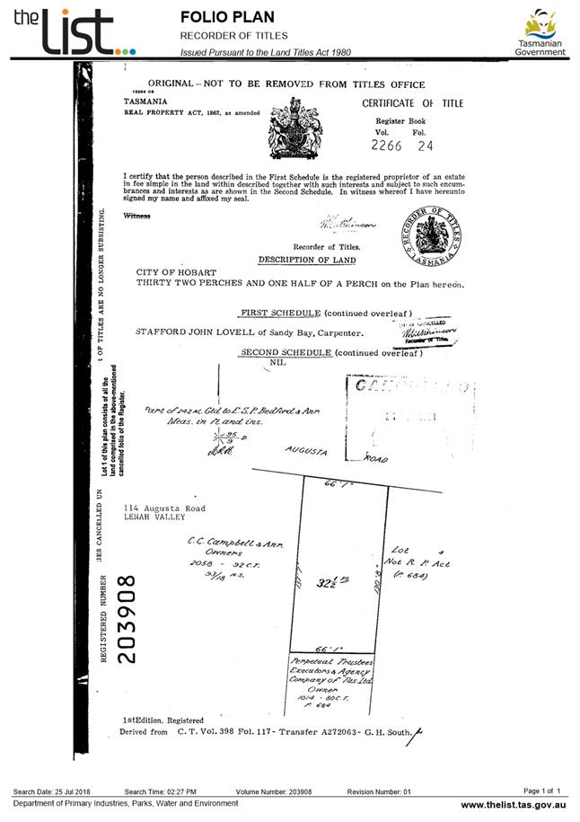
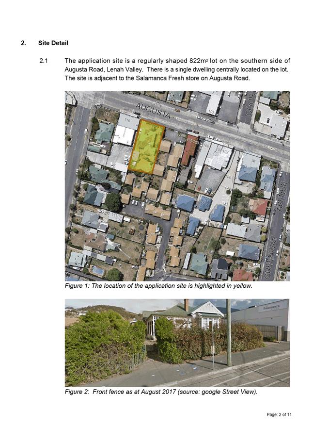
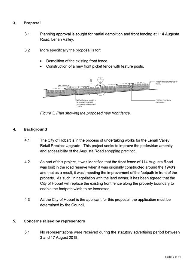
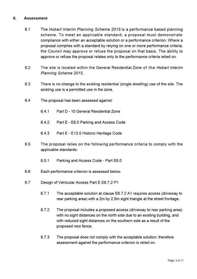
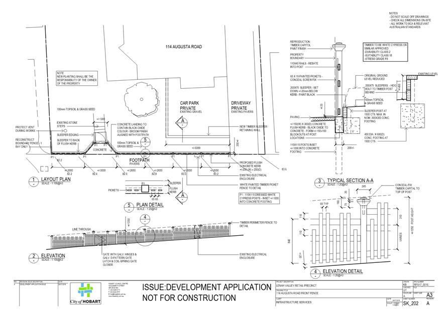
7.1.4 114 Augusta Road, Lenah Valley - Partial Demolition and Front Fencing
Address: 114 Augusta Road, Lenah Valley
Proposal: Partial Demolition and Front Fencing
Expiry Date: 6 September 2018
Extension of Time: Not applicable
Author: Helen Ayers
|
REcommendation That: Pursuant to the Hobart Interim Planning Scheme 2015, the Council approve the application for partial demolition and front fencing at 114 Augusta Road, Lenah Valley for the reasons outlined in the officer’s report and a permit containing the following conditions be issued:
GEN
The use and/or development must be substantially in accordance with the documents and drawings that comprise PLN18484 114 AUGUSTA ROAD LENAH VALLEY TAS 7008 Final Planning Documents, except where modified below.
Reason for condition
To clarify the scope of the permit.
ENG 1
The cost of repair of any damage to the Council's infrastructure resulting from the implementation of this permit, must be met by the owners within 30 days of the completion of the development or as otherwise determined by the Council.
A photographic record of the Council's infrastructure adjacent to the subject site must be provided to the Council prior to any commencement of works.
A photographic record of the Council’s infrastructure (e.g. existing property service connection points, roads, buildings, stormwater, footpaths, driveway crossovers and nature strips, including if any, preexisting damage) will be relied upon to establish the extent of damage caused to the Council’s infrastructure during construction. In the event that the owner/developer fails to provide to the Council a photographic record of the Council’s infrastructure, then any damage to the Council's infrastructure found on completion of works will be deemed to be the responsibility of the owner.
Reason for condition
To ensure that any of the Council's infrastructure and/or siterelated service connections affected by the proposal will be altered and/or reinstated at the owner’s full cost.
ENV 1
Sediment and erosion control measures sufficient to prevent sediment from leaving the site must be installed prior to any disturbance of the site, and maintained until all areas of disturbance have been stabilized or revegetated.
Advice: For further guidance in preparing a Soil and Water Management Plan – in accordance with Fact sheet 3 Derwent Estuary Program click here.
Reason for condition
To avoid the sedimentation of roads, drains, natural watercourses, Council land that could be caused by erosion and runoff from the development, and to comply with relevant State legislation.
HER 16
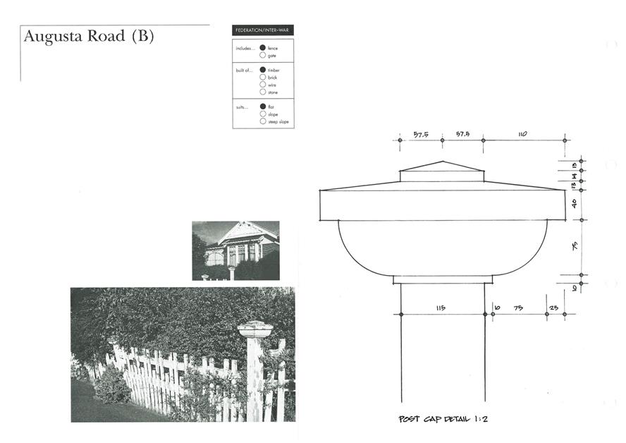
The front fence and gate along the Augusta Road boundary, (specifically the post capitals and the front pedestrian gate) must accord as closely as possible with the drawings and photographs for the original fence as presented in the Council's publication "New Fences for Old Houses".
Prior to the commencement of any site works, revised plans must be submitted and approved showing the front fence in accordance with the above requirement.
Advice: · The relevant page showing detailed drawings and photographs of the original fence from Council's publication "New Fences for Old Houses" is attached to this permit. · Once the design drawing has been approved Council will issue a condition endorsement (see general advice on how to obtain condition endorsement).
Reason for condition
To ensure that development at a heritage place is undertaken in a sympathetic manner which does not cause loss of historic cultural heritage significance.
ADVICE
The following advice is provided to you to assist in the implementation of the planning permit that has been issued subject to the conditions above. The advice is not exhaustive and you must inform yourself of any other legislation, bylaws, regulations, codes or standards that will apply to your development under which you may need to obtain an approval. Visit the Council's website for further information.
Prior to any commencement of work on the site or commencement of use the following additional permits/approval may be required from the Hobart City Council.
CONDITION ENDORSEMENT PLANNING
If a condition endorsement is required by a planning condition above, you will need to submit the relevant documentation to satisfy the condition via the Condition Endorsement Submission on Council's online services eplanning
Where building approval is also required, it is recommended that documentation for condition endorsement be submitted well before submitting documentation for building approval. Failure to address condition endorsement requirements prior to submitting for building approval may result in unexpected delays.
Once approved, the Council will respond to you via email that the condition has been endorsed (satisfied). Detailed instructions can be found here.
BUILDING PERMIT
You may need building approval in accordance with the Building Act 2016. Click here for more information.
This is a Discretionary Planning Permit issued in accordance with section 57 of the Land Use Planning and Approvals Act 1993.
WEED CONTROL
Effective measures are detailed in the Tasmanian Washdown Guidelines for Weed and Disease Control: Machinery, Vehicles and Equipment (Edition 1, 2004). The guidelines can be obtained from the Department of Primary Industries, Parks, Water and Environment website.
WASTE DISPOSAL
It is recommended that the developer liaise with the Council’s Cleansing and Solid Waste Unit regarding reducing, reusing and recycling materials associated with demolition on the site to minimise solid waste being directed to landfill.
Further information regarding waste disposal can also be found on the Council’s website.
FEES AND CHARGES
Click here for information on the Council's fees and charges.
DIAL BEFORE YOU DIG
Click here for dial before you dig information.
|
Attachment a: PLN-18-484
- 114 AUGUSTA ROAD LENAH VALLEY TAS 7008 - Planning Committee or Delegated
Report ⇩ ![]()
Attachment
b: PLN-18-484
- 114 AUGUSTA ROAD LENAH VALLEY TAS 7008 - CPC Agenda Documents ⇩ ![]()
Attachment
c: PLN-18-484
- 114 AUGUSTA ROAD LENAH VALLEY TAS 7008 - CPC Agenda Documents - New Fences
for Old Houses ⇩ ![]()
|
Item No. 7.1.4 |
Agenda (Open Portion) City Planning Committee Meeting - 27/8/2018 |
Page 305 ATTACHMENT a |
|
Agenda (Open Portion) City Planning Committee Meeting - 27/8/2018 |
Page 316 ATTACHMENT b |
|
Item No. 7.1.4 |
Agenda (Open Portion) City Planning Committee Meeting - 27/8/2018 |
Page 319 ATTACHMENT b |
|
Item No. 7.1.4 |
Agenda (Open Portion) City Planning Committee Meeting - 27/8/2018 |
Page 321 ATTACHMENT c |
|
Agenda (Open Portion) City Planning Committee Meeting |
Page 324 |
|
|
|
27/8/2018 |
|
8. Reports
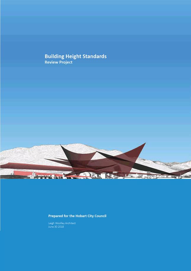
8.1 Central Hobart Building Height Standards Review Project - Proposed Planning Scheme Amendments
Report of the Manager Planning Policy & Heritage and the Director City Planning of 16 August 2018 and attachments.
Delegation: Council
|
Item No. 8.1 |
Agenda (Open Portion) City Planning Committee Meeting |
Page 325 |
|
|
27/8/2018 |
|
REPORT TITLE: Central Hobart Building Height Standards Review Project - Proposed Planning Scheme Amendments
REPORT PROVIDED BY: Manager Planning Policy & Heritage
Director City Planning
1. Report Purpose and Community Benefit
1.1. This report presents the outcomes of Building Height Standards Review Project (Leigh Woolley June 2018) (Attachment A) and outlines possible amendments to the Hobart Interim Planning Scheme 2015 (HIPS 2015) and the Sullivans Cove Planning Scheme 1997 (SCPS 1997) to implement the outcomes of the review.
1.2. The proposal benefits the community by helping to ensure that the height of development in the central area of Hobart and Sullivans Cove makes a positive contribution to the streetscape and townscape values and meets community expectations.
2. Report Summary
2.1. This report presents the outcomes of Building Height Standards Review Project (Leigh Woolley June 2018) (Attachment A) and outlines possible amendments to the Hobart Interim Planning Scheme 2015 (HIPS 2015) and the Sullivans Cove Planning Scheme 1997 (SCPS 1997) to implement the outcomes of the review.
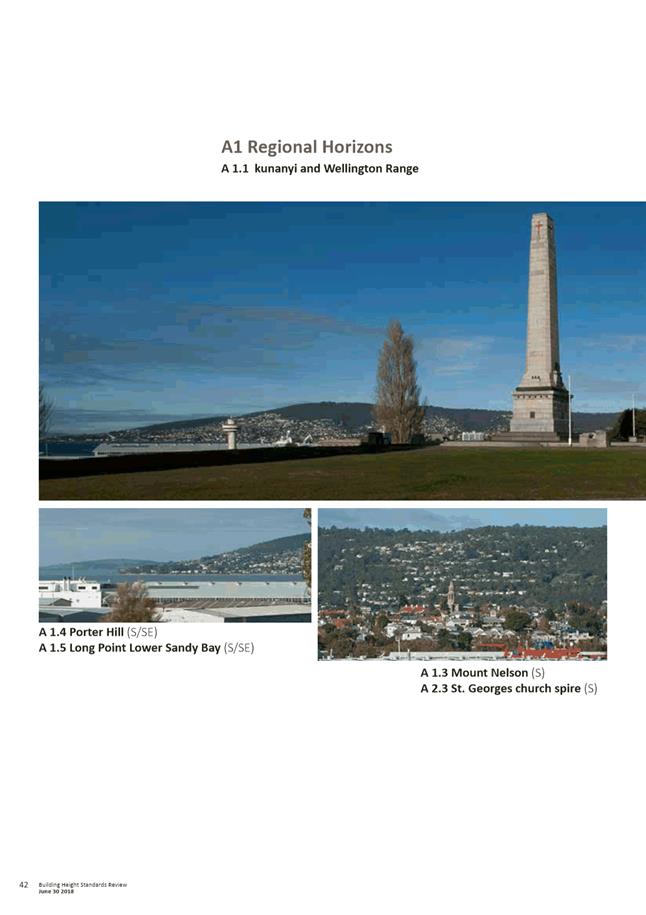
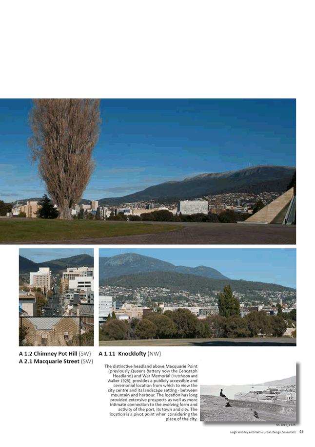
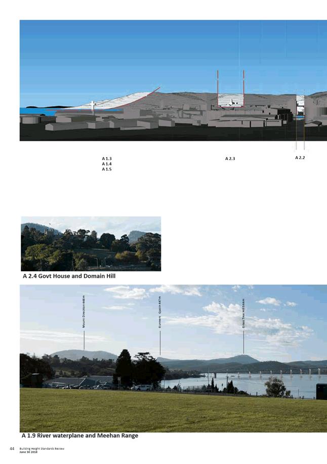
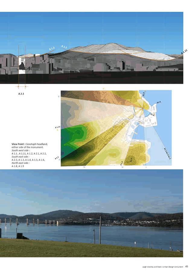
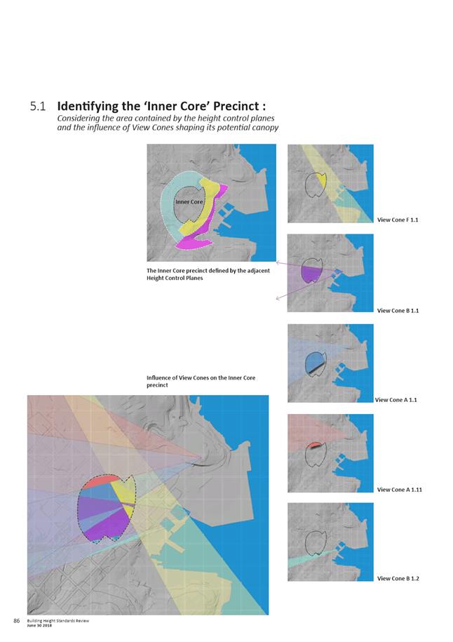
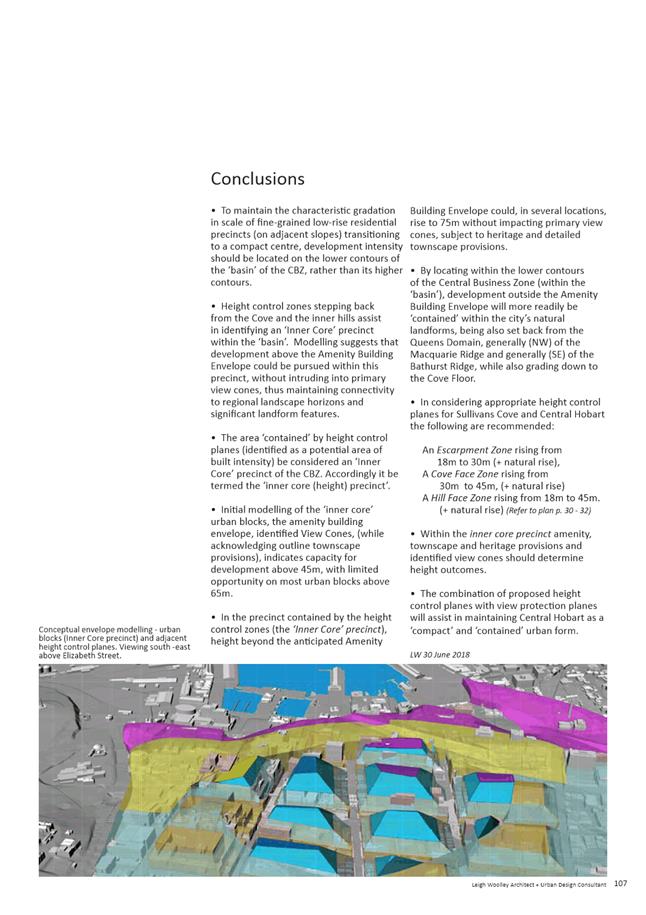
2.2. The key conclusions from the Building Height Standards Review are as follows:
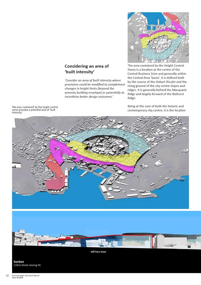
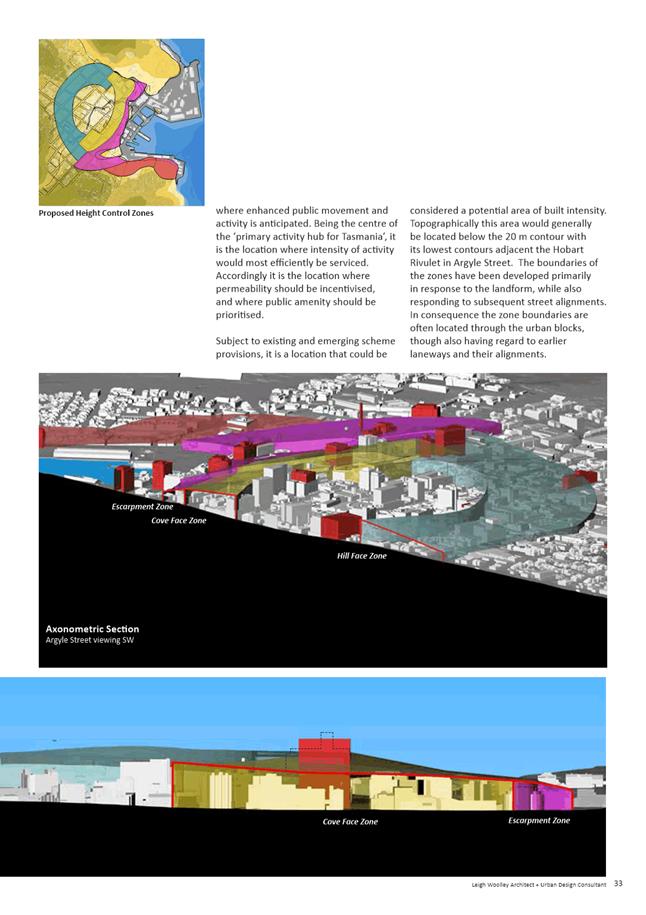
2.2.1. To maintain the transition in scale from the low-rise residential precincts (on adjacent slopes) to a compact centre, development intensity should be located on the lower contours of the ‘basin’ of the Central Business Zone, rather than its higher contours.
2.2.2. Height control zones stepping back from the Cove and the inner hills assist in identifying an ‘Inner Core’ precinct within the ‘basin’. Modelling suggests that development above the Amenity Building Envelope could be pursued within this precinct, without intruding into primary view cones.
2.2.3. Initial modelling of the ‘inner core’ urban blocks, the amenity building envelope, identified view cones, while acknowledging townscape provisions, indicates capacity for development above 45m, with limited opportunity on most urban blocks above 65m. In some locations height could rise to 75m without impacting primary view cones, subject to heritage and detailed townscape provisions.
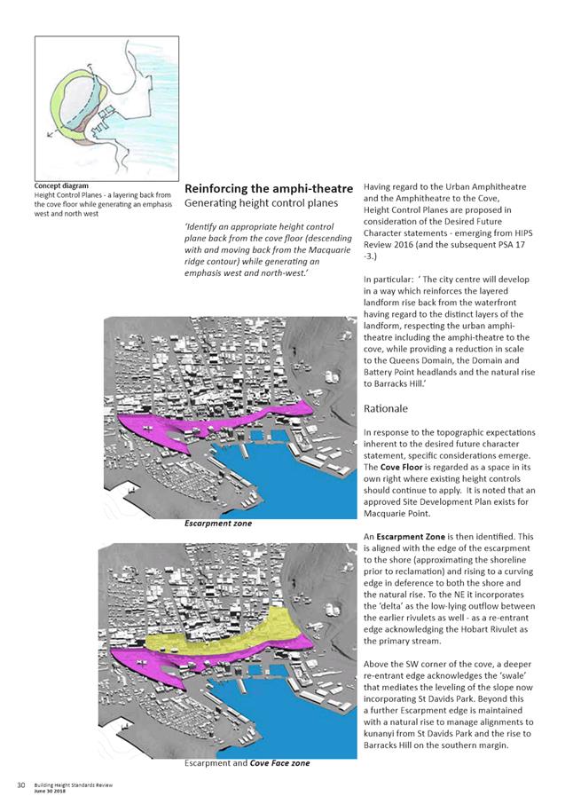
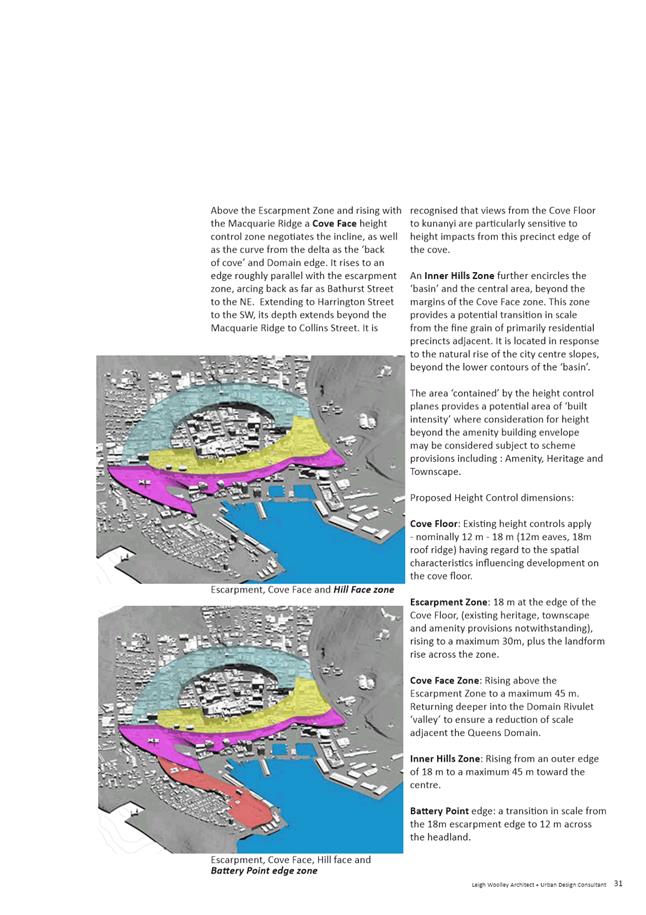
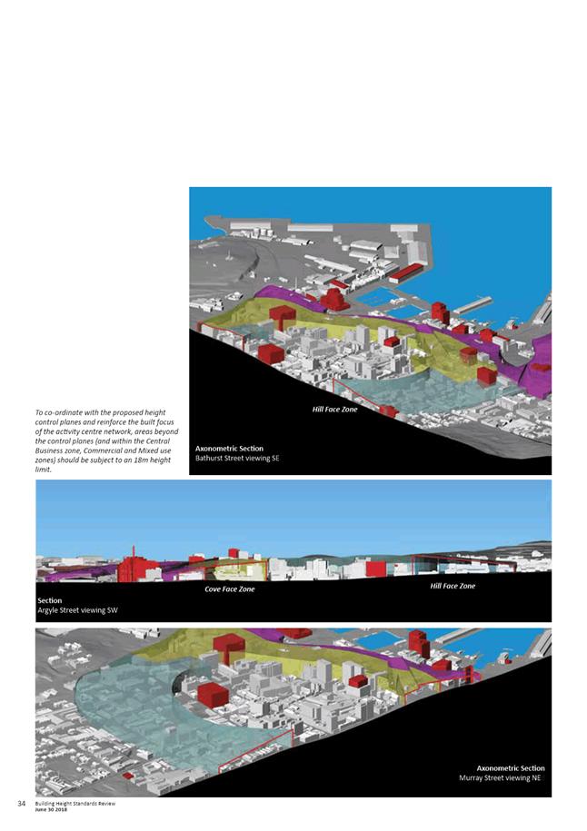
2.2.4. In considering appropriate height control planes for Sullivans Cove and Central Hobart the following are recommended:
- An Escarpment Zone rising from 18m to 30m (+ natural rise);
- A Cove Face Zone rising from 30m to 45m, (+ natural rise;
- A Hill Face Zone rising from 18m to 45m (+ natural rise).
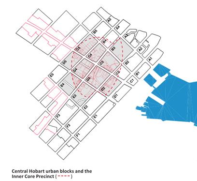
2.2.5. Within the inner core precinct (shown below); amenity, townscape and heritage provisions and identified view cones should determine height outcomes.
2.2.6. The combination of proposed height control planes with view protection planes will assist in maintaining Central Hobart as a ‘compact’ and ‘contained’ urban form.
2.3. The Urban Design Advisory Panel has considered and supports the underlying approach taken by the Building Height Standards Review in determining appropriate maximum building heights for the Central Business Zone and adjacent Zones and also the draft amendments as modified following input from the Panel.
2.4. The outcomes of the Building Height Standards Review are considered to be an appropriate response to the project brief. The implementation of the height control planes and protection of important views through the planning scheme provisions will assist in maintaining the streetscape and townscape values of Central Hobart and Sullivans Cove and provide greater certainty and direction in the consideration of discretionary proposals.
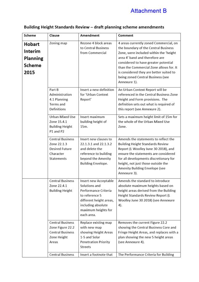
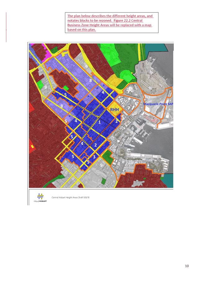
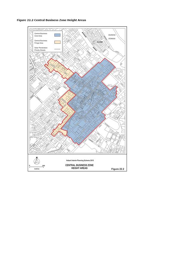
2.5. The proposed planning scheme amendments based on the outcomes of the Review are provided in Attachment B along with a summary and explanation of each amendment. In the Central Business Zone it is proposed that the height control planes be implemented by the designation of 5 Height Areas as shown on the map in Attachment C. The key amendments are outlined in section 5 of this report.
|
That the Council endorse the release of the Building Height Standards Review (L Woolley, 30 June 2018) report (Attachment A) and the suggested planning scheme amendments (Attachment B) to implement its recommendations, for public comment for a 4 week period, prior to consideration of formally endorsing the report and initiating any planning scheme amendments in response. |
4. Background
4.1. The current development standards for buildings in the Central Business Zone in the HIPS2015 were formulated after a detailed review and analysis of land use and development patterns in the central city area. The development standards address building height, setbacks, design, passive surveillance, outdoor storage, pedestrian links, heritage, streetscape and sense of scale, wind effects and solar penetration.
4.2. At its meeting on 3 July 2017, the Council endorsed the recommendations of the Central Business Zone Height Standards – Performance Criteria Review report (Woolley 2016) and initiated the PSA-17-3 Amendments to the HIPS2015 to implement the recommendations of that report in relation to streetscape and townscape values. A modified version of those amendments were approved by the Tasmanian Planning Commission on 3 August 2018.
4.3. At its meeting on 3 July
2017, the Council also resolved that:
A further report to Council be prepared addressing the additional
analysis required in relation to a number of issues including the preparation
of design guidelines, modelling of buildings in certain locations, development
of spatial principles to inform appreciation of the ‘urban amphitheatre’,
designation of additional view protection planes, height control planes and
specification of maximum height limits.
4.4. At its meeting on 9 October 2017, the Council endorsed the project brief for that work and subsequently Leigh Woolley - Architect and Urban Design Consultant was commissioned to undertake the project.
5. Proposal and Implementation
5.1. It is proposed that the Council endorse the release of the Building Height Standards Review (L Woolley, 30 June 2018) report and the suggested planning scheme amendments to implement its recommendations for public comment prior to formally endorsing the report and initiating any planning scheme amendments in response.
Building Height Standards Review (Woolley 2018)
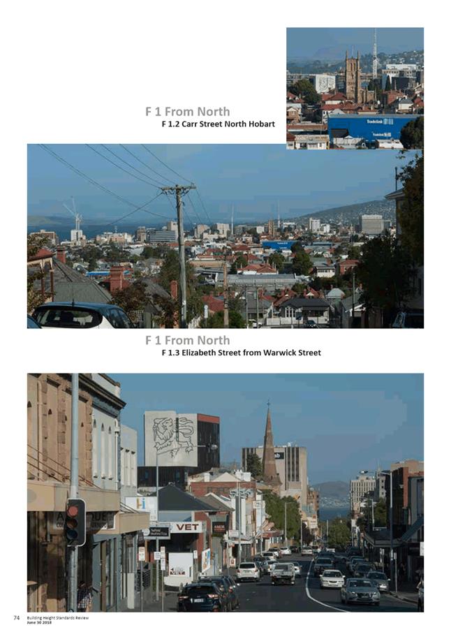
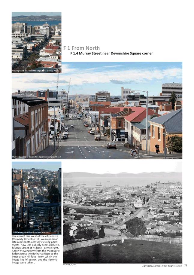
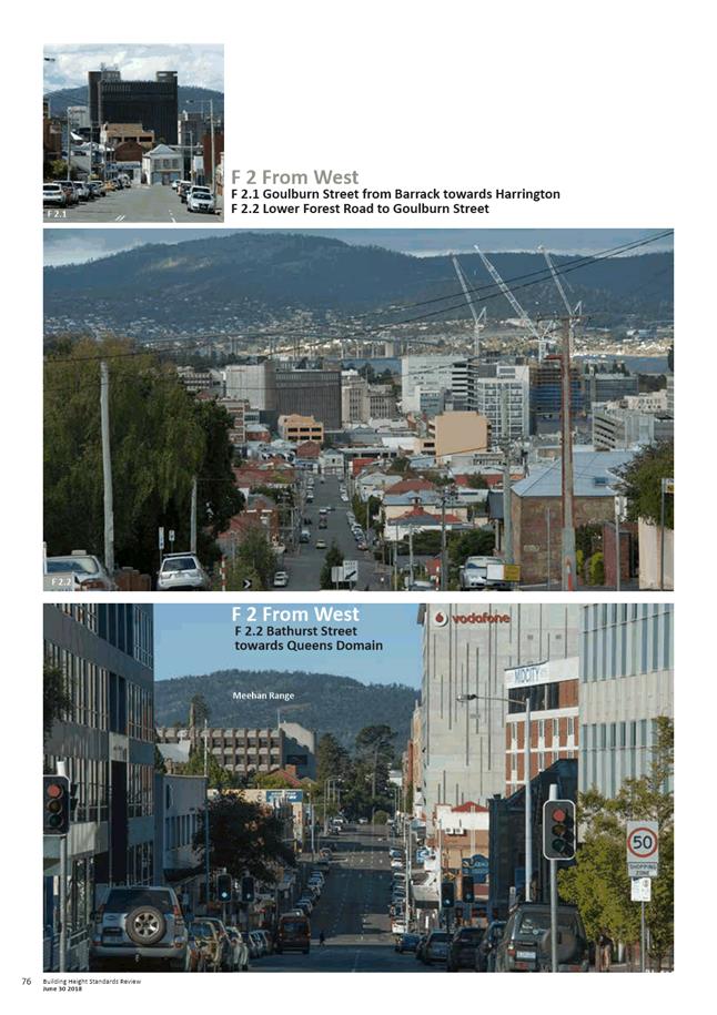
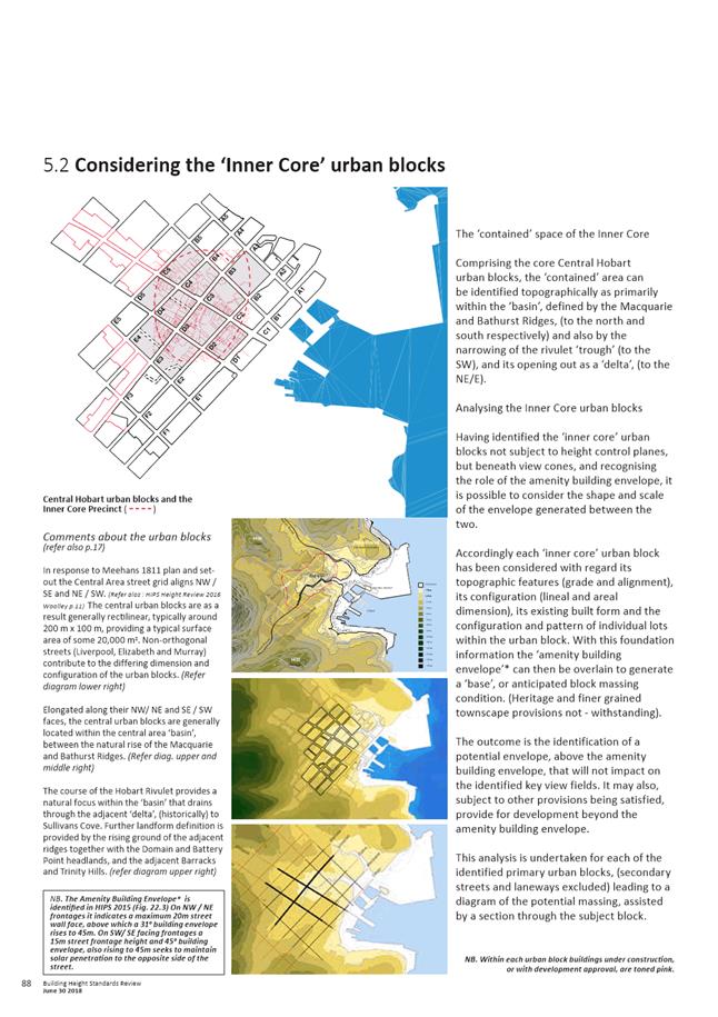
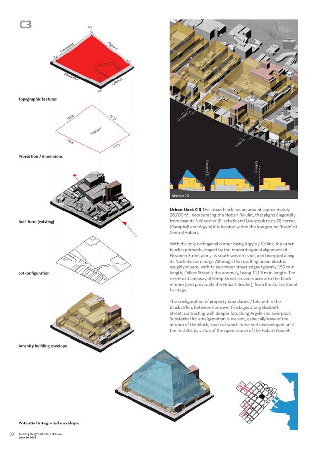
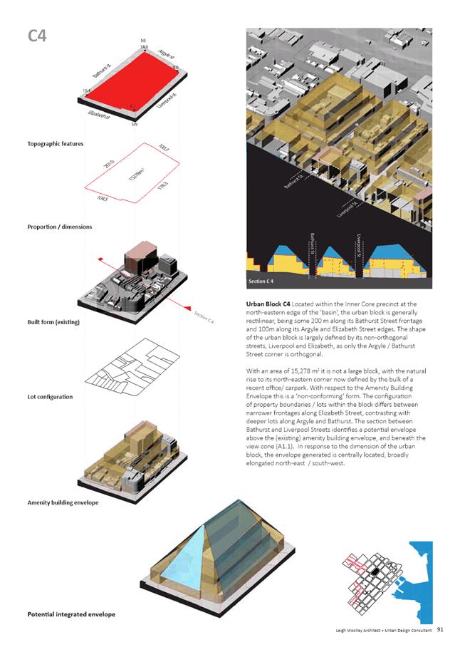
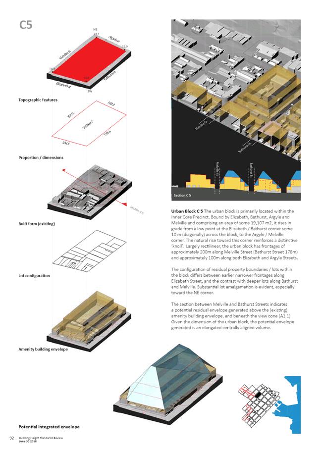
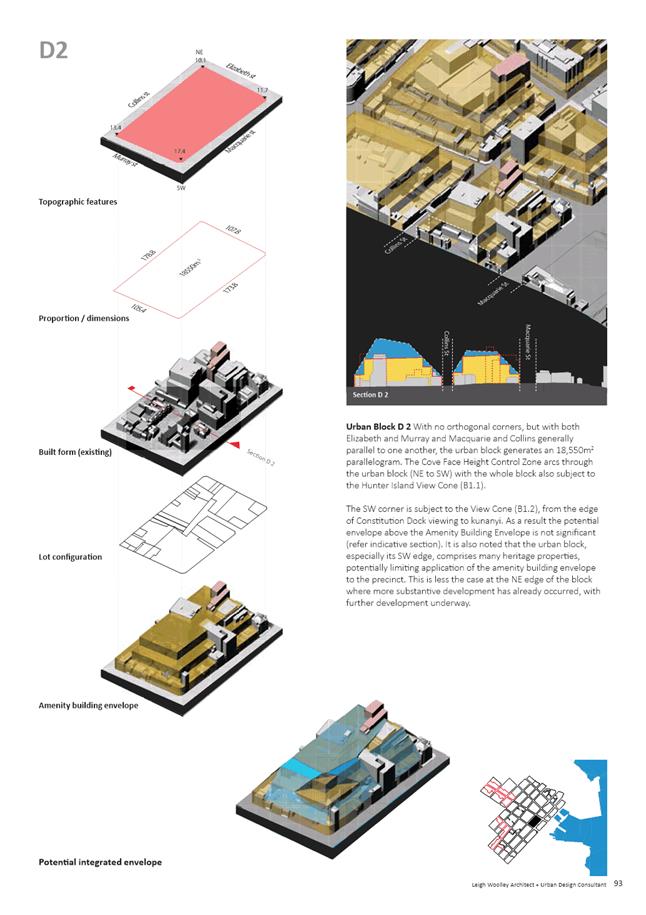
5.2. In response to the brief the Building Height Standards Review (2018) has addressed the following:
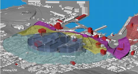
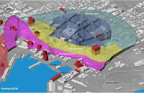
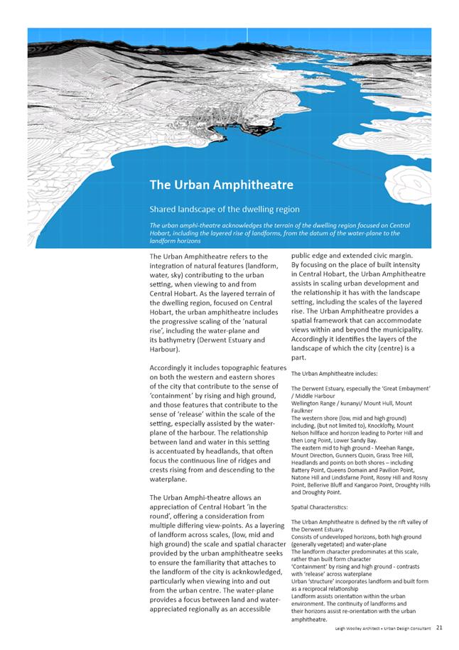
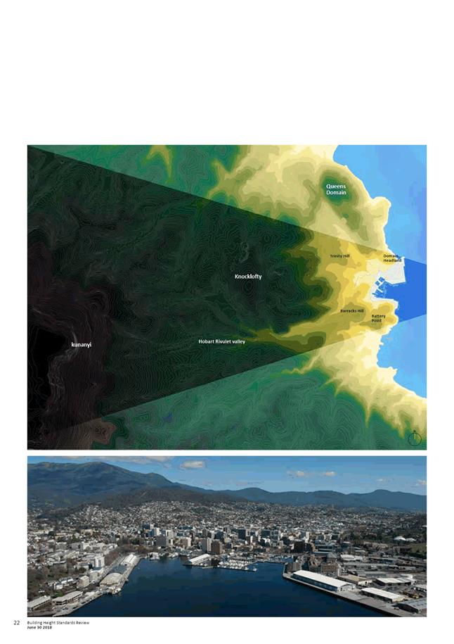
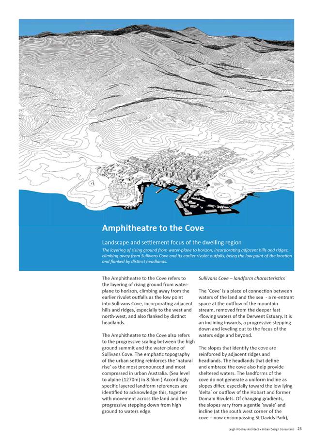
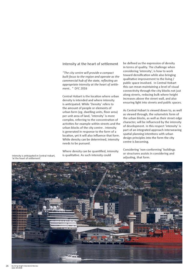
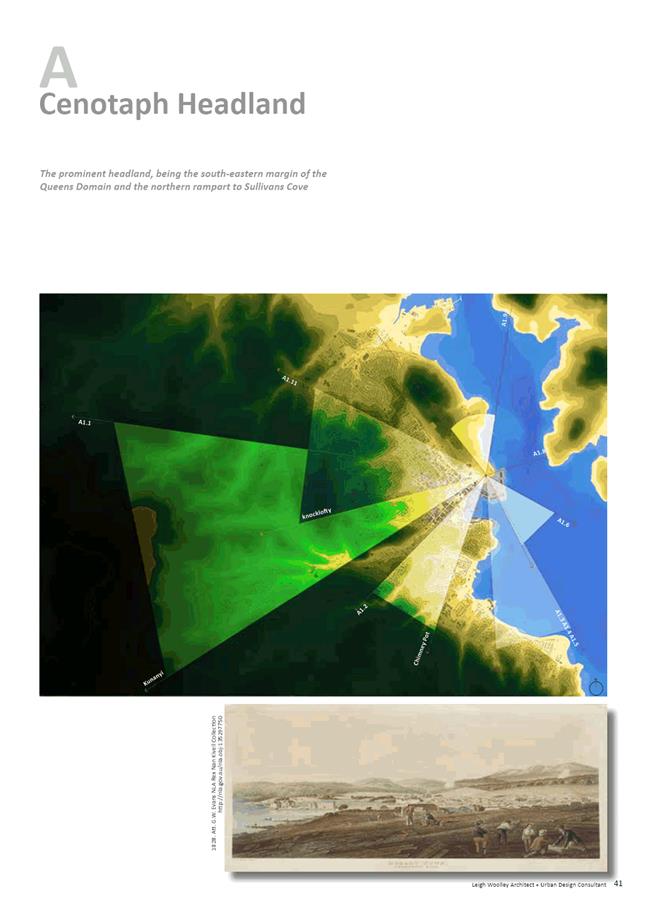
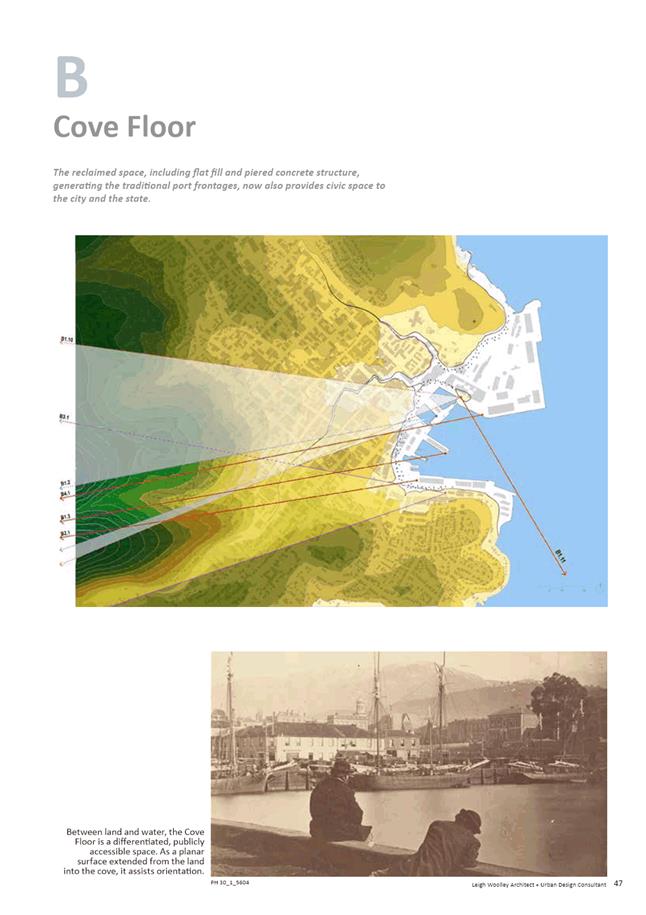
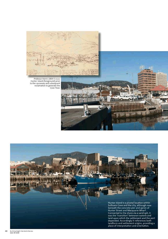
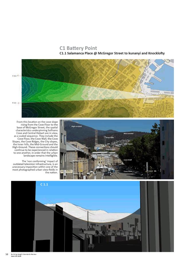
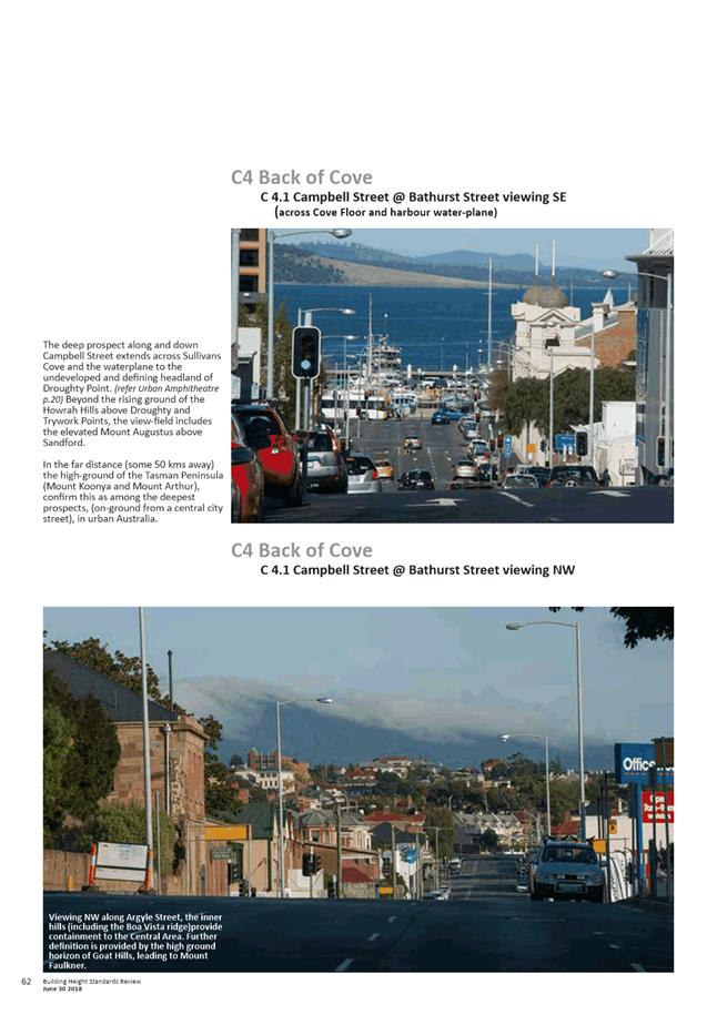
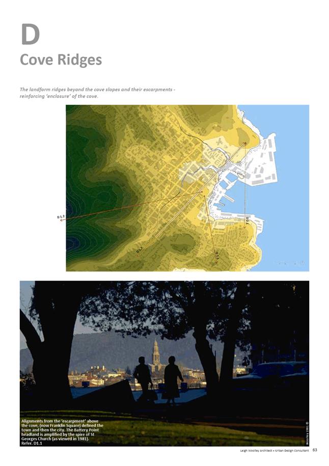
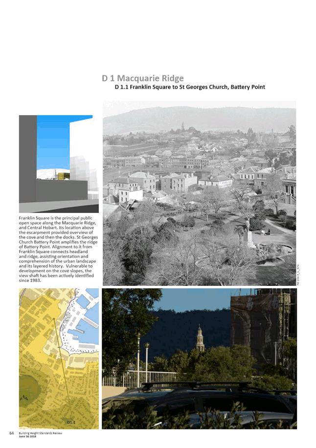
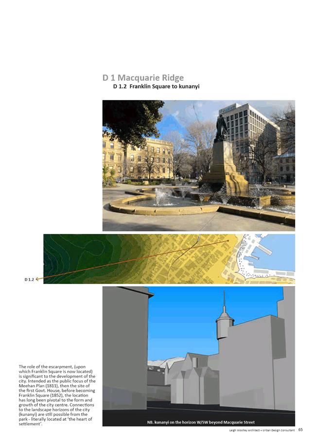
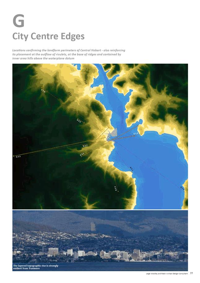
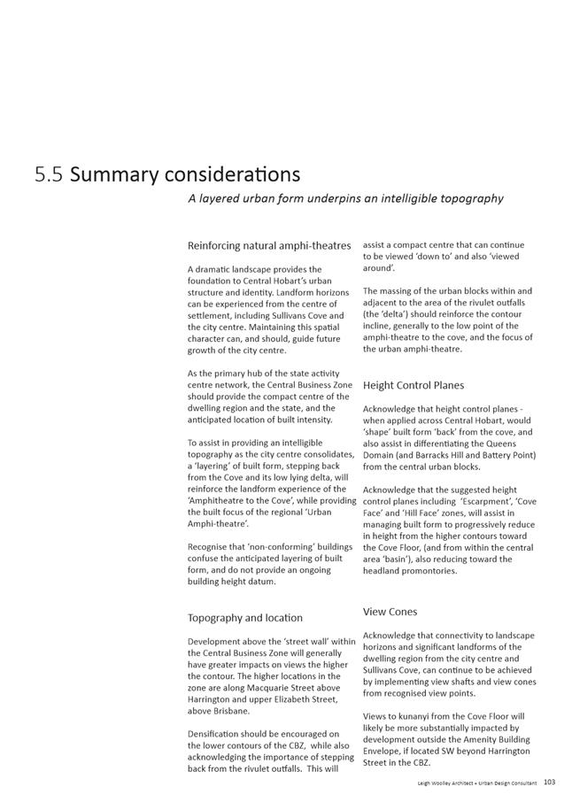
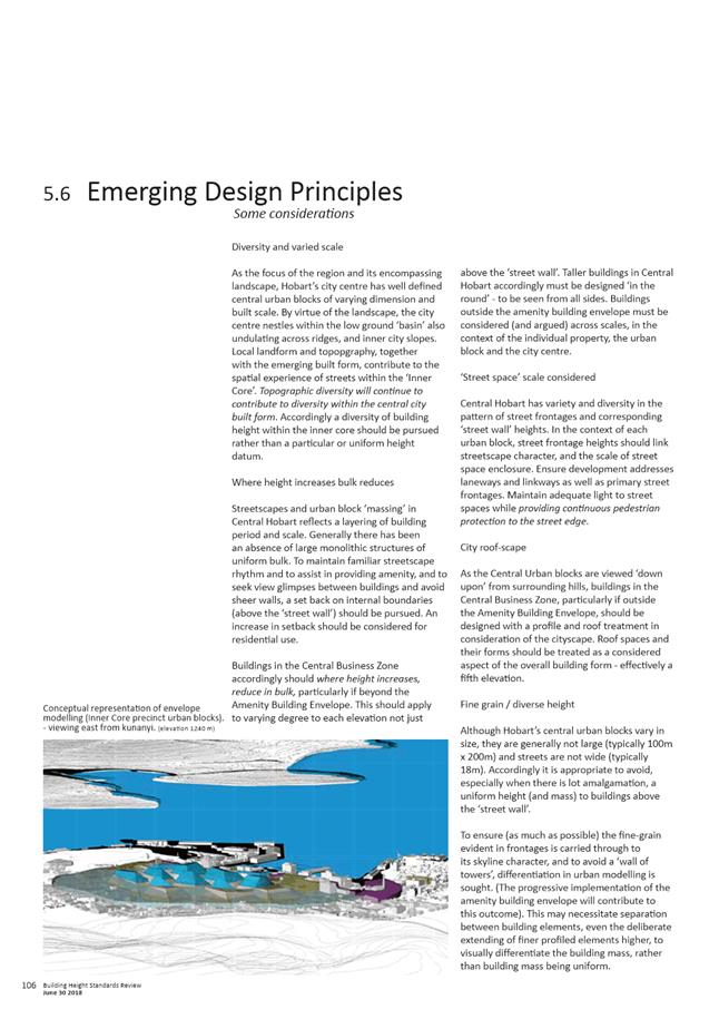
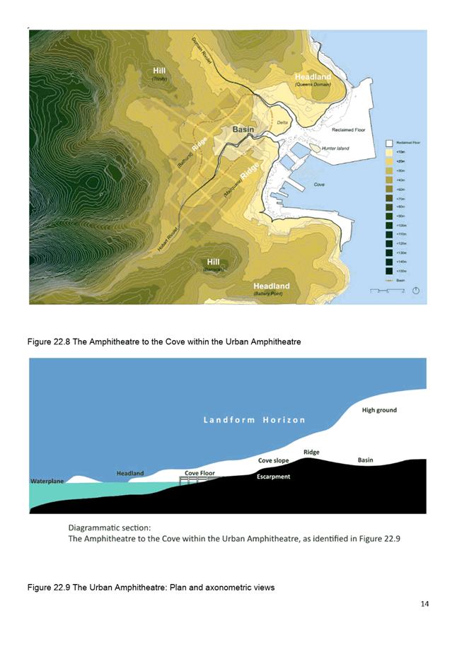
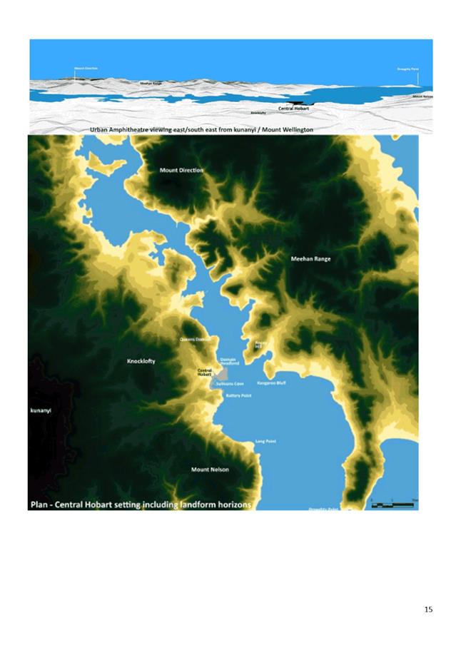
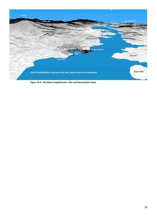
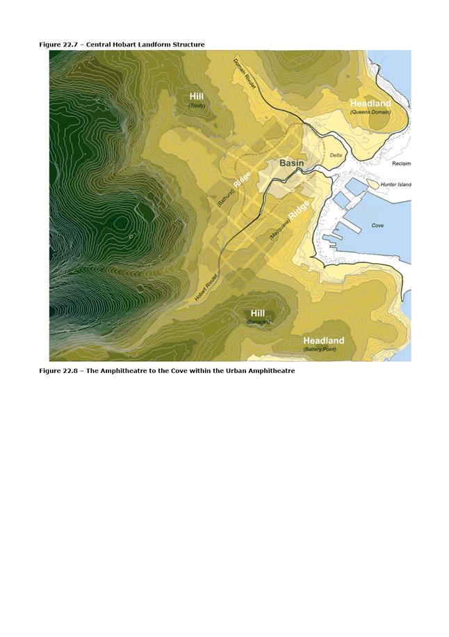
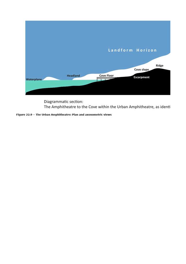
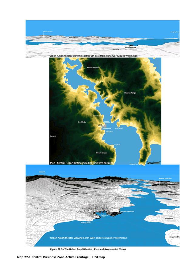
5.2.1. Urban Context - the context of a ‘small city in a large landscape’ is discussed in response to the settlement expansion of the city region and the role of Central Hobart in the urban hierarchy. The key spatial characteristics of the Urban Amphitheatre and the Amphitheatre to the Cove are identified in order to locate and appreciate ‘intensity at the heart of settlement’ in Central Hobart.
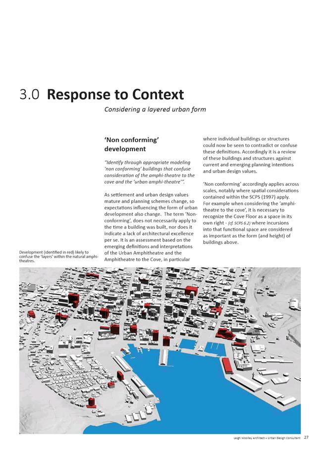
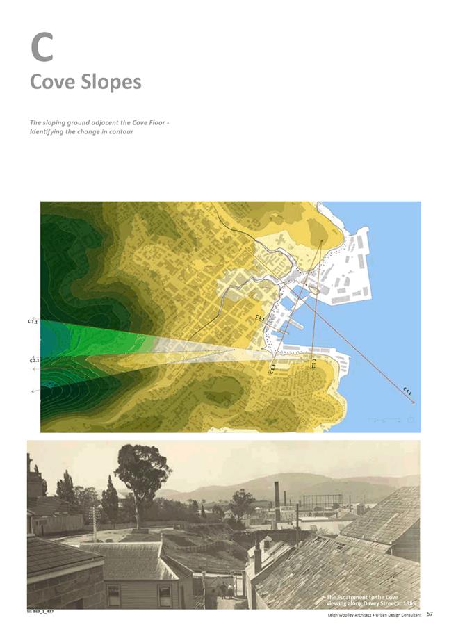
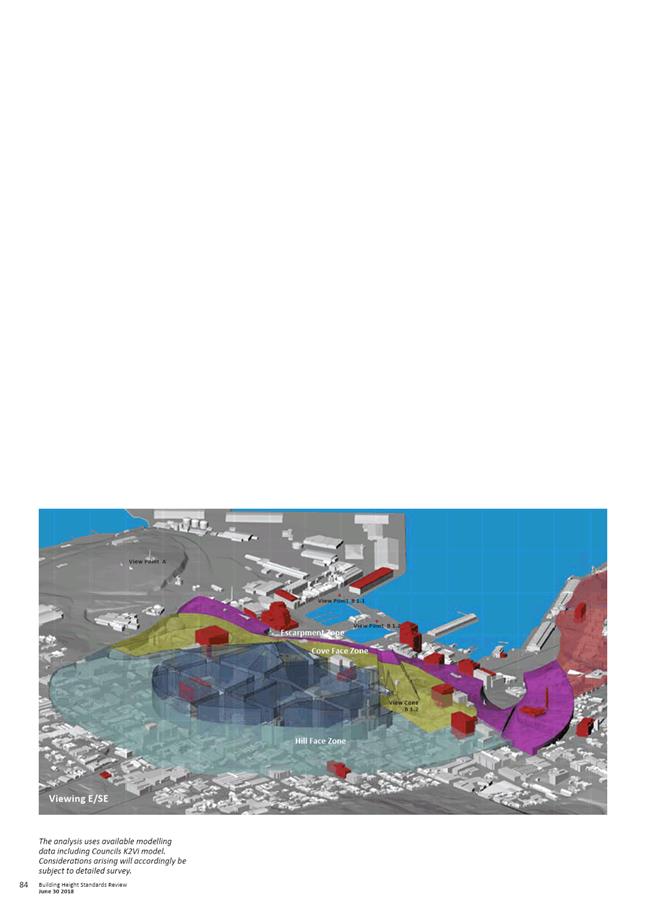
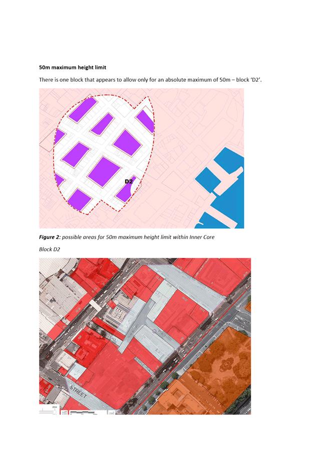
5.2.2. Response to the context - in order to consider a layering of the urban form ‘non-conforming’ development is identified, along with height control planes between Sullivans Cove and the city centre and then the inner hills.
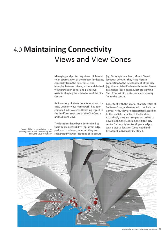
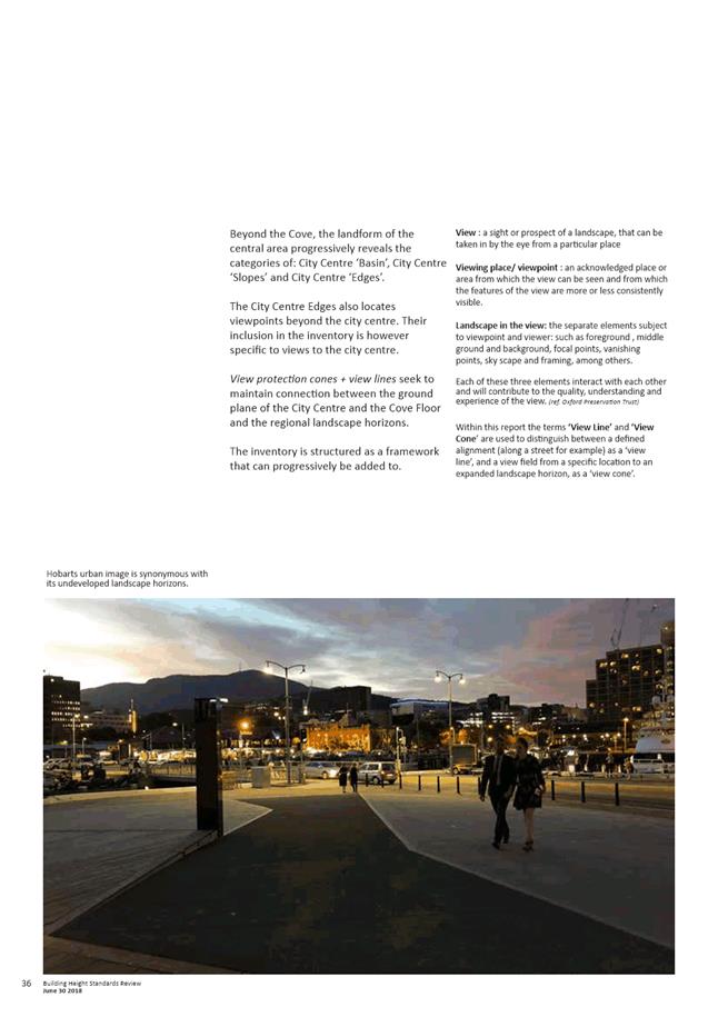
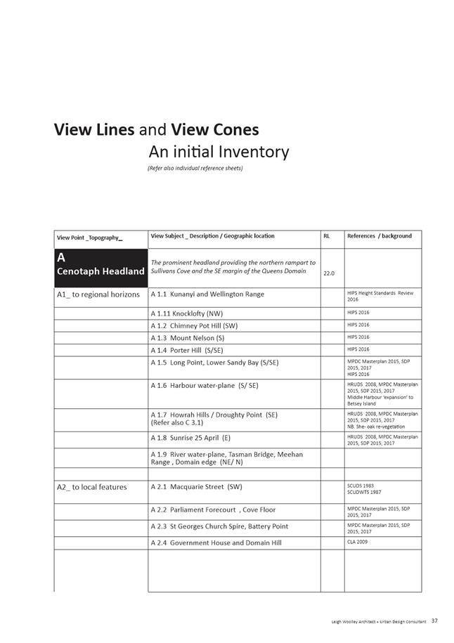
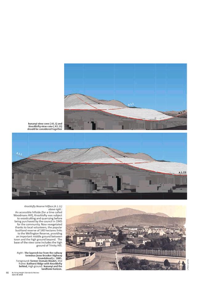
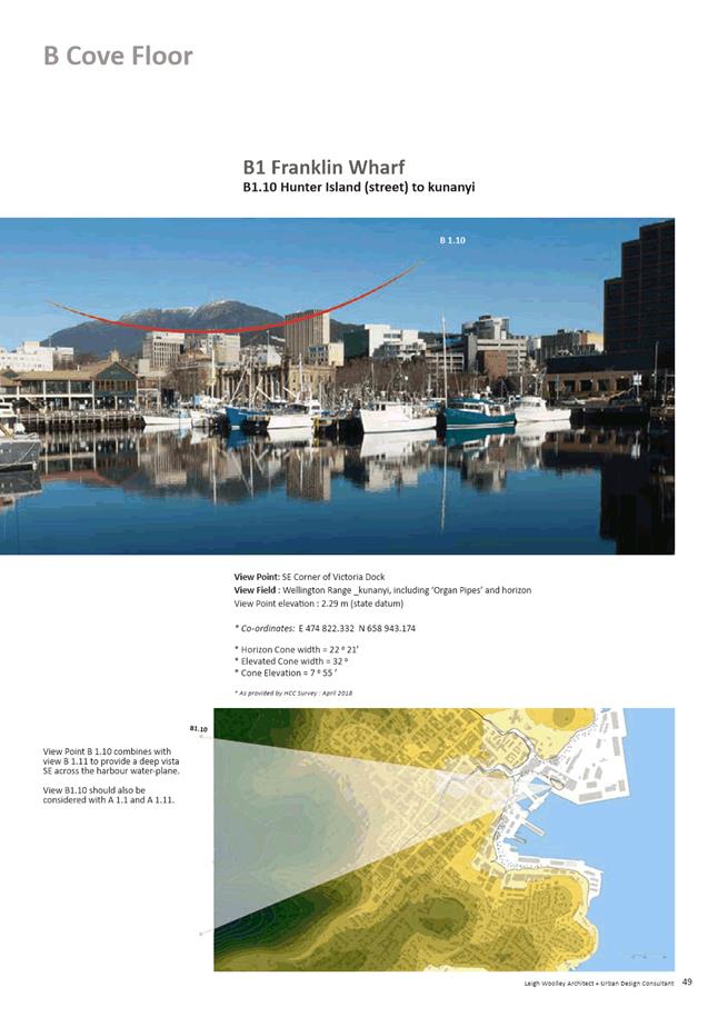
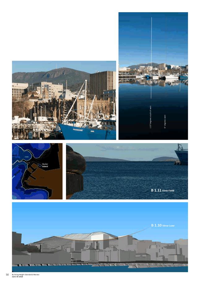
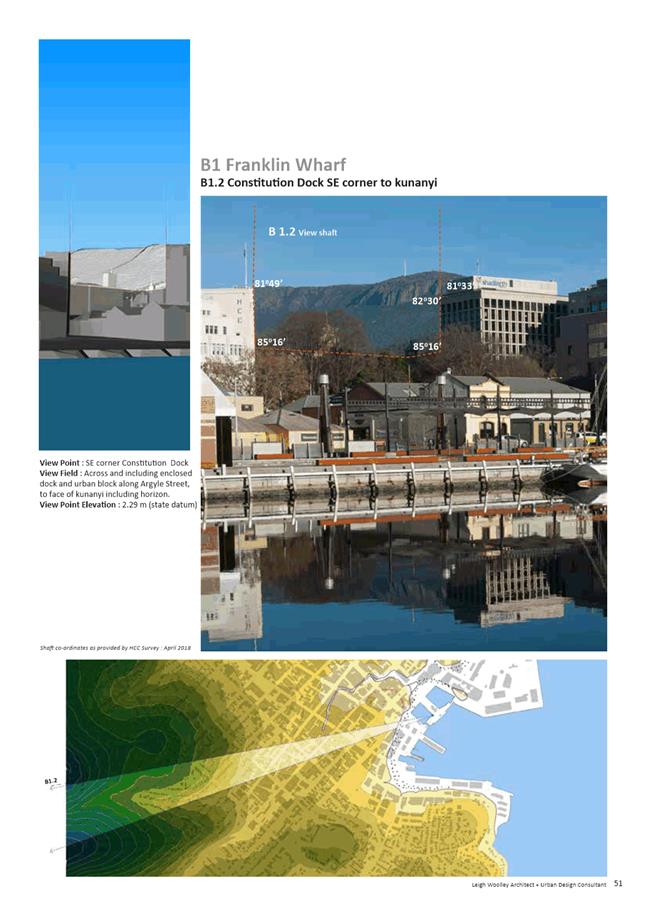
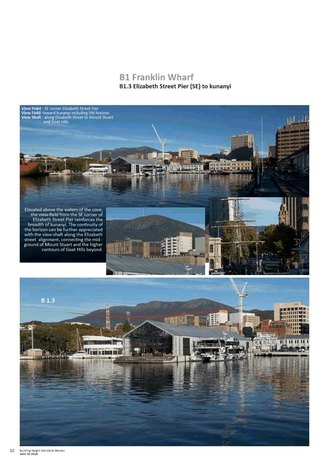
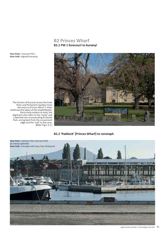
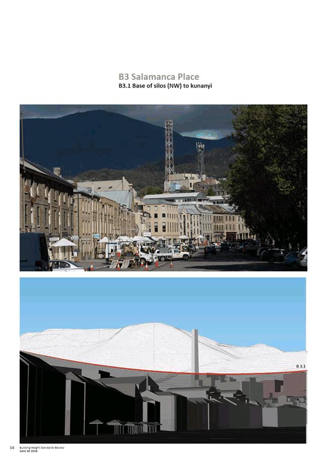
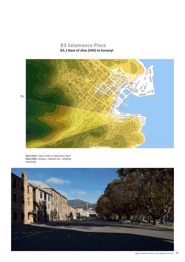
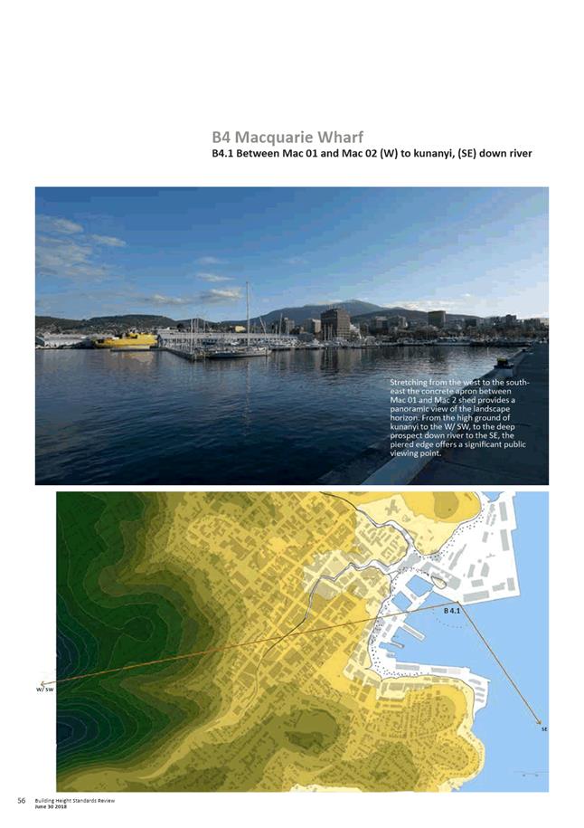
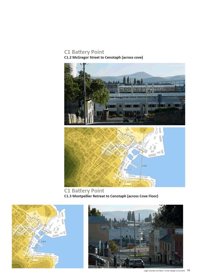
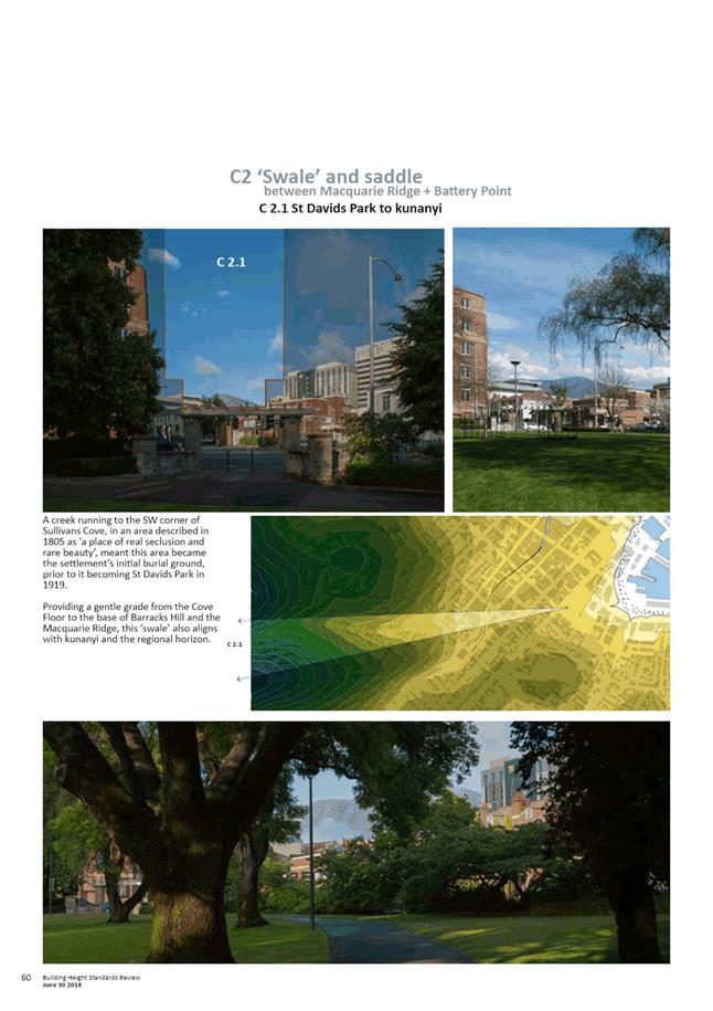
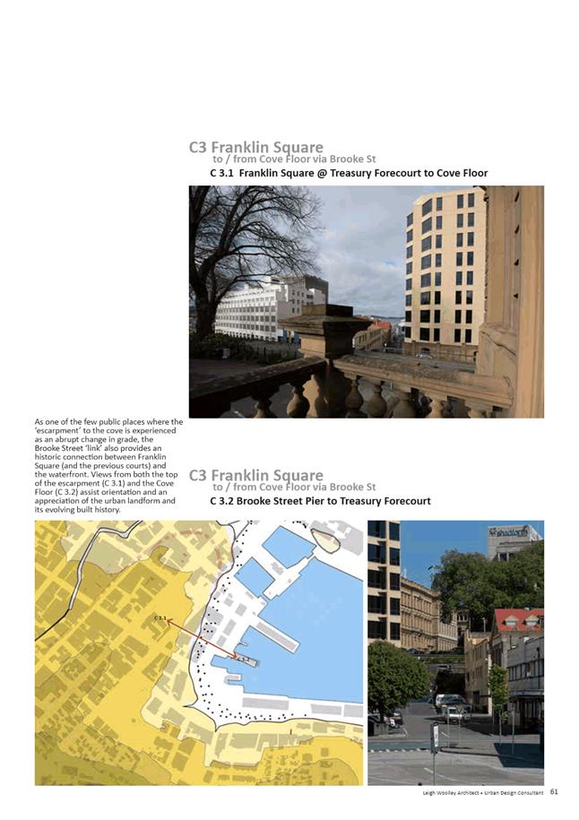
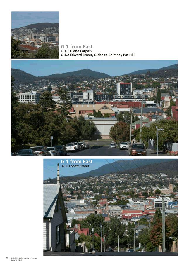
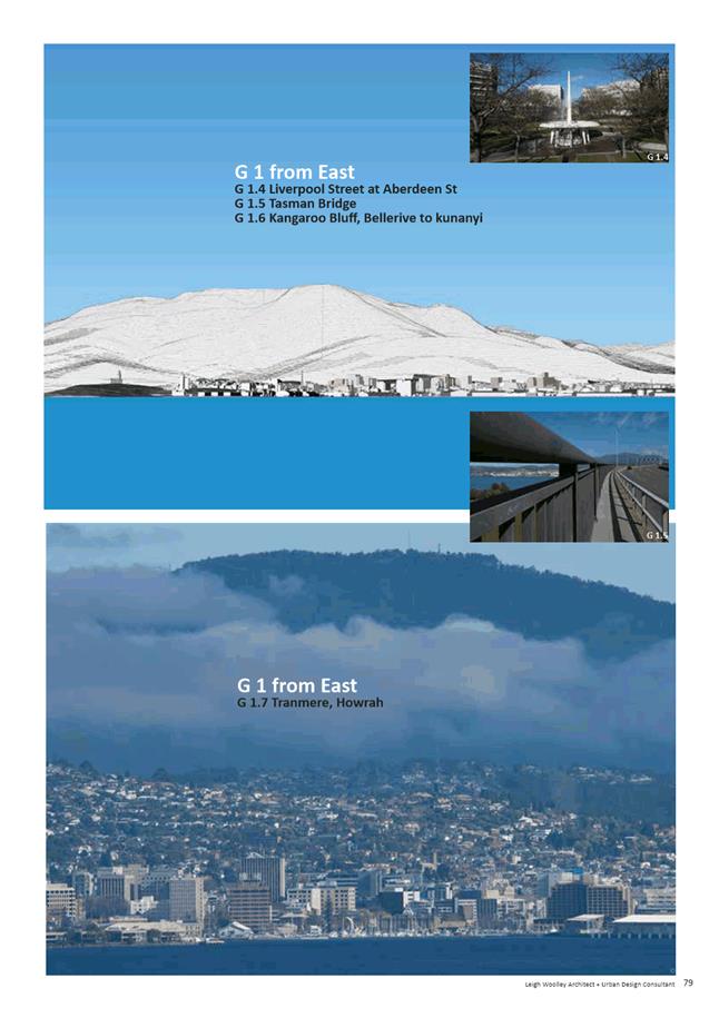
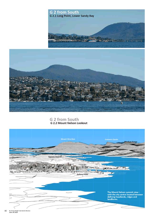
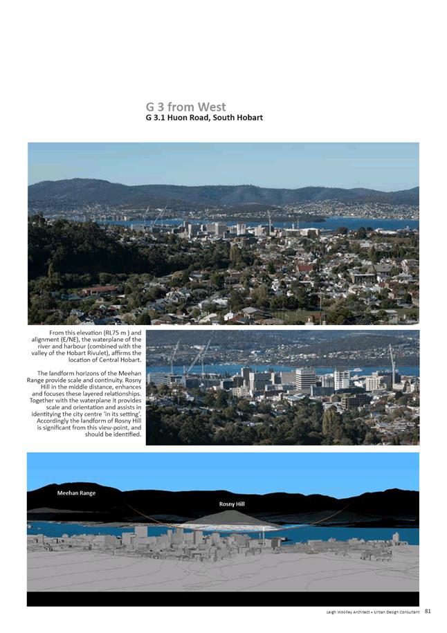
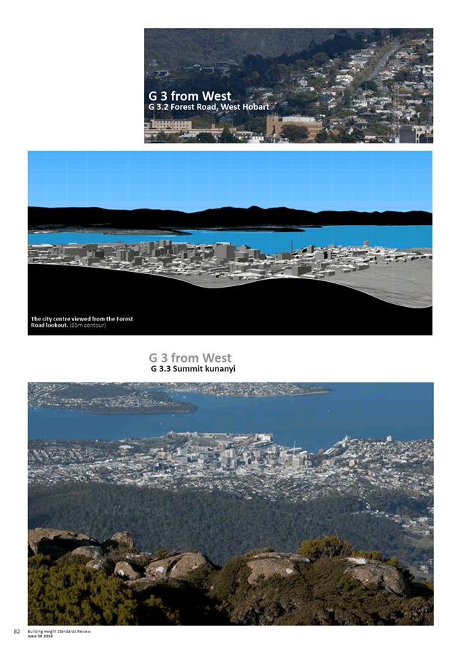
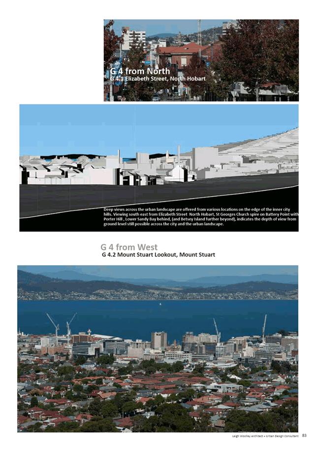
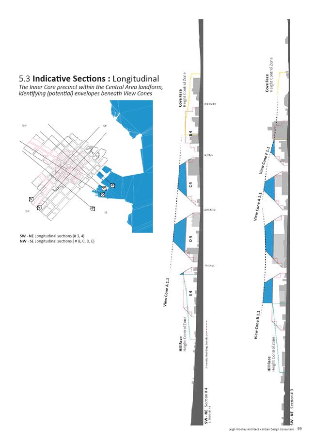
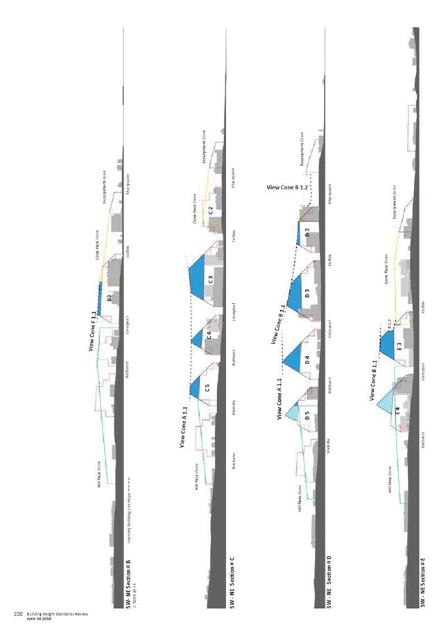
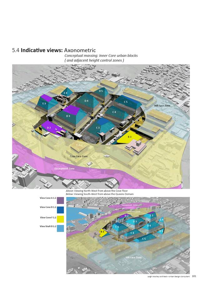
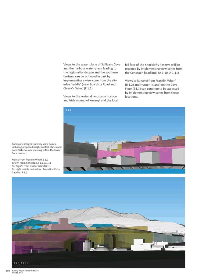
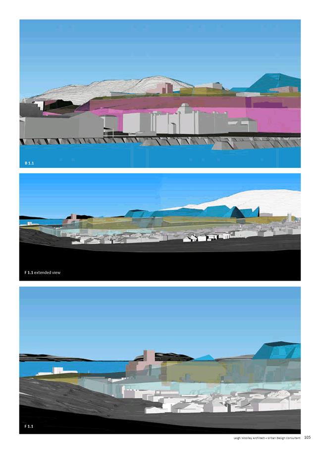
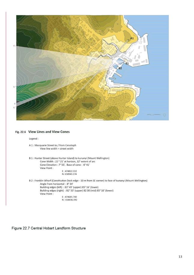
5.2.3. Maintaining Connectivity - an inventory of view lines, view cones and view planes is provided to identify the connecting alignments between the city centre and the regional landscape horizons. Individual view lines as well as view cones are identified, with modelling indicating the potential connectivity with and without height control planes.
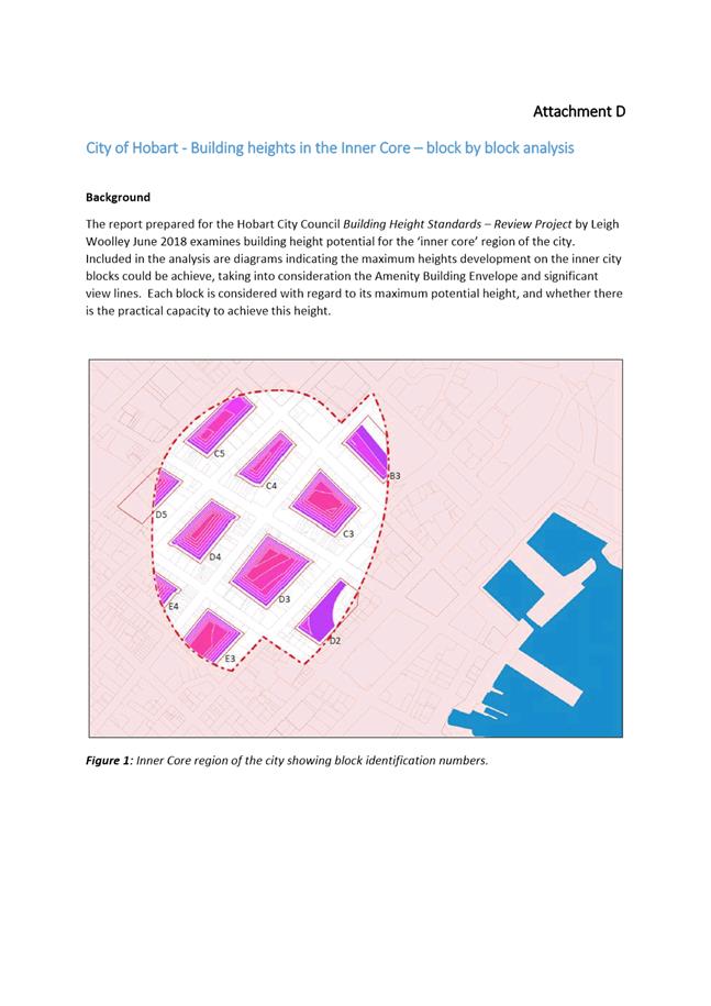
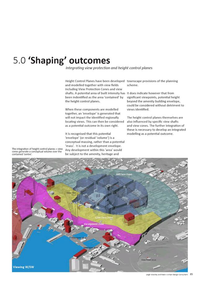
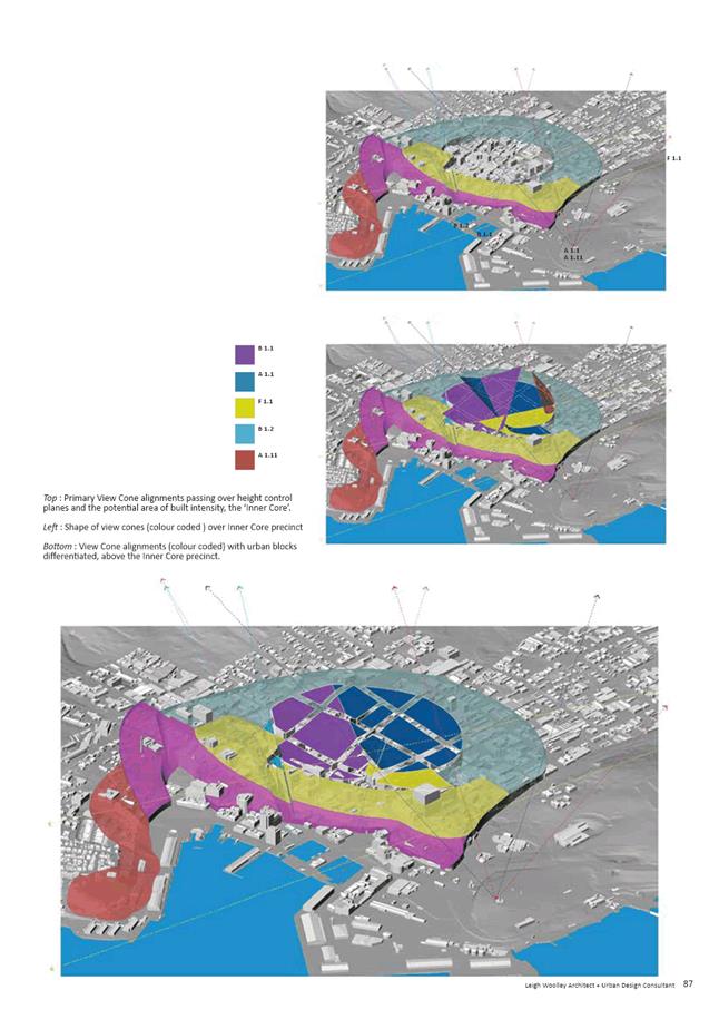
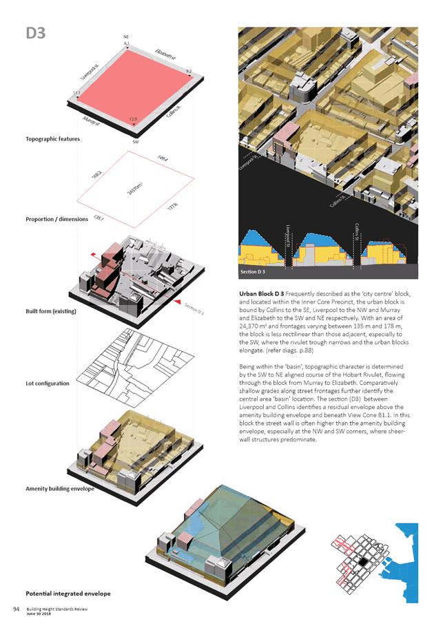
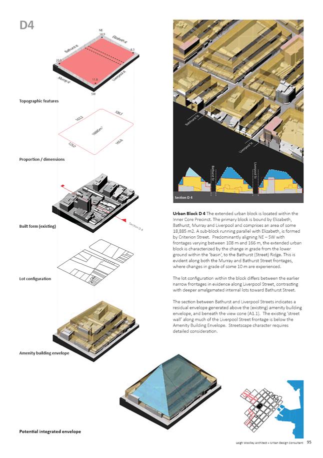
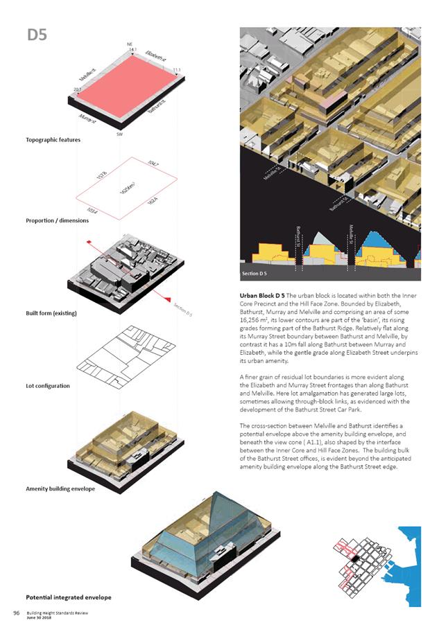
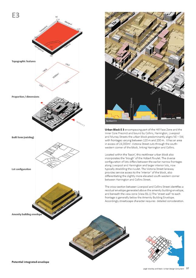
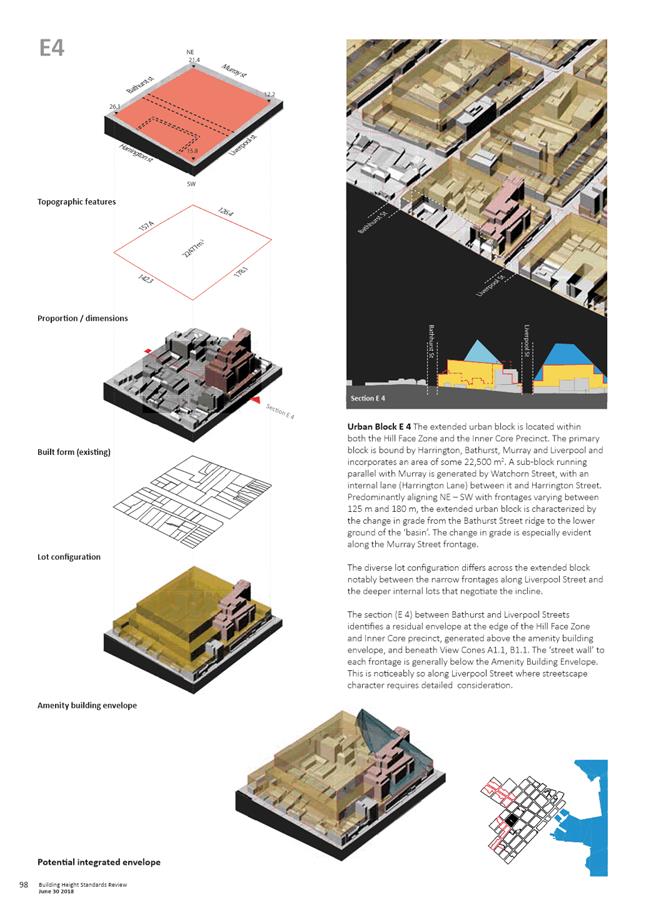
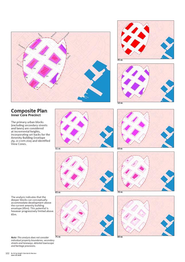
5.2.4. Shaping Outcomes - the last section combines the outcomes of the previous sections, integrating view protection and height control planes (with the existing amenity building envelope) to generate a potential envelope for each urban block as shown below (extract from pages 84 and 85 of the Building Height Standards Review). This also assists in considering design principles in response to the identified townscape values.
5.3. The key conclusions from the Building Height Standards Review are as follows:
5.3.1. To maintain the transition in scale from the low-rise residential precincts (on adjacent slopes) to a compact centre, development intensity should be located on the lower contours of the ‘basin’ of the Central Business Zone, rather than its higher contours.
5.3.2. Height control zones stepping back from the Cove and the inner hills assist in identifying an ‘Inner Core’ precinct within the ‘basin’. Modelling suggests that development above the Amenity Building Envelope could be pursued within this precinct, without intruding into primary view cones.
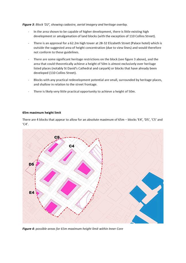
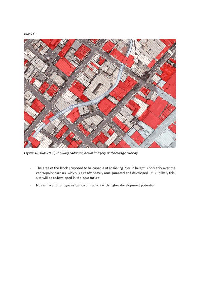
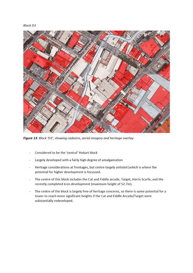
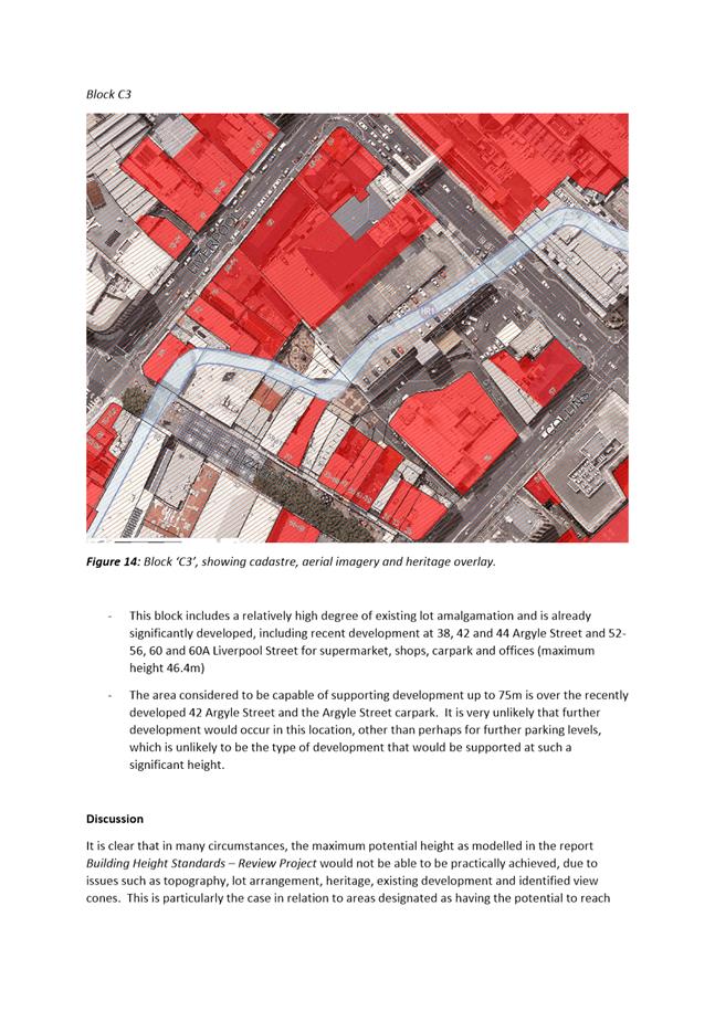
5.3.3. Initial modelling of the ‘inner core’ urban blocks, the amenity building envelope, identified view cones, while acknowledging townscape provisions, indicates capacity for development above 45m, with limited opportunity on most urban blocks above 65m. In some locations height could rise to 75m without impacting primary view cones, subject to heritage and detailed townscape provisions.
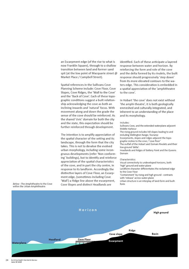
5.3.4. In considering appropriate height control planes for Sullivans Cove and Central Hobart the following are recommended in the Review:
- An Escarpment Zone rising from 18m to 30m (+ natural rise);
- A Cove Face Zone rising from 30m to 45m, (+ natural rise;
- A Hill Face Zone rising from 18m to 45m (+ natural rise).
5.3.5. Within the inner core precinct; amenity, townscape and heritage provisions and identified view cones should determine height outcomes.
5.3.6. The combination of proposed height control planes with view protection planes will assist in maintaining Central Hobart as a ‘compact’ and ‘contained’ urban form.
5.4. It is also noted that as the principal activity centre in the regional hierarchy of Activity Centre Network in the Southern Tasmania Regional Land Use Strategy, the Central Business Zone (as the core of the Hobart Activity Centre) is intended to be the densest and most compact development precinct in the state. The ‘primary hub for Tasmania where a significant proportion of all employment opportunities within the region should continue to be focussed’.
Urban Design Advisory Panel Consideration
5.5. The Urban Design Advisory Panel received a briefing on the Building Height Standards Review from Leigh Woolley at its meeting on 27 July 2018 and provided the following advice:
Building Height Standards Review
5.6. The Panel supports the underlying approach taken by the Building Height Standards Review in determining appropriate maximum building heights for the Central Business Zone and adjacent Zones. In doing so the Panel strongly affirms the comments made in the report that the maximum heights nominated must be expected to be further moderated on a site by site basis after having taken into consideration local townscape, streetscape, heritage and other urban design matters.
Associated Draft Scheme Amendments
5.7. Council officers presented draft amendments to the Hobart Interim Planning Scheme to put into effect the principal outcomes of the Building Height Standards Review.
5.8. The Panel agreed with the principal outcomes of the Building Height Standards Review around maximum height. The Panel raised in respect of the Amendment, the following matters:
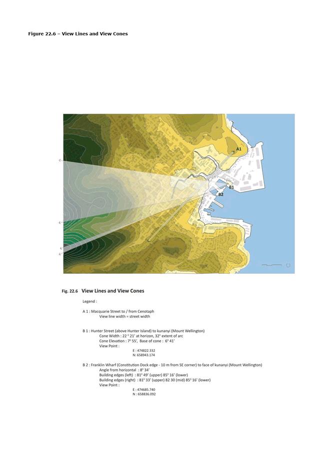
5.9. View cones - The Panel noted that 22.4.1 P1.1 will be amended to include additional view cones identified in the Building Height Standards Review in Figure 22.6. The Panel endorses this approach as it highlights the protection of views which is the fundamental guiding principle underpinning the Building Height Standards Review recommendations. It was also suggested that the view cone data be included on the K2VI model and to make the model available to prospective applicants.
5.10. Height Areas Map – Figure 22.2 - The Panel noted that this is a replacement Map for Figure 22.2. The Panel supports the Height Area approach taken. It does suggest that the boundary between height areas 2, 3, 4 and 5 be adjusted in the vicinity of Barrack Street (old Hutchins School site) in order to reflect a better transition in these areas to adjacent Zones that have strong heritage and residential values.
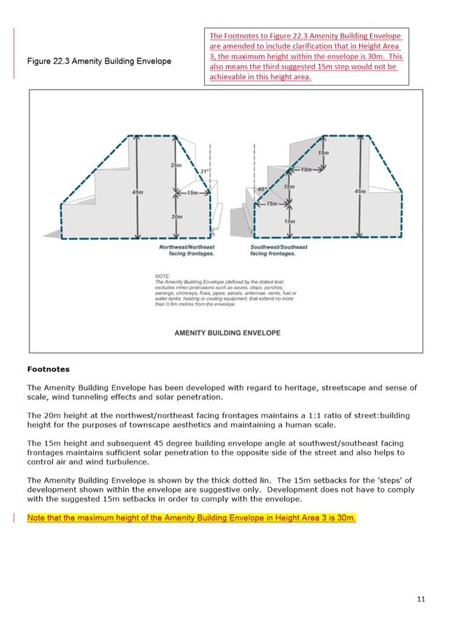
5.11. Building Amenity Envelope 22.3 - The Panel noted the envelope is intended to also apply to buildings lower than maximum height of 45m and suggested that this be clarified by a reference on 22.3 to acknowledge maximum heights of 30m in Area 3.
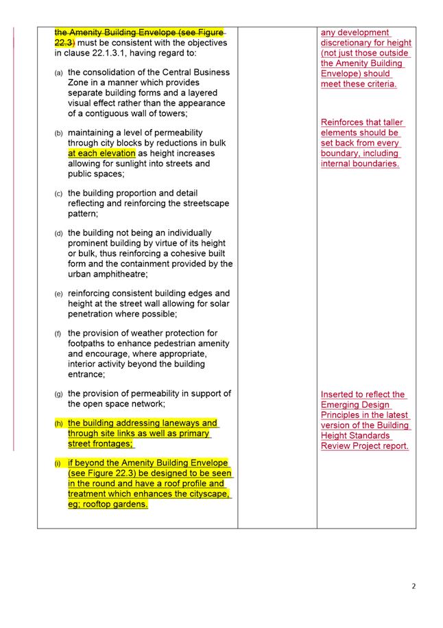
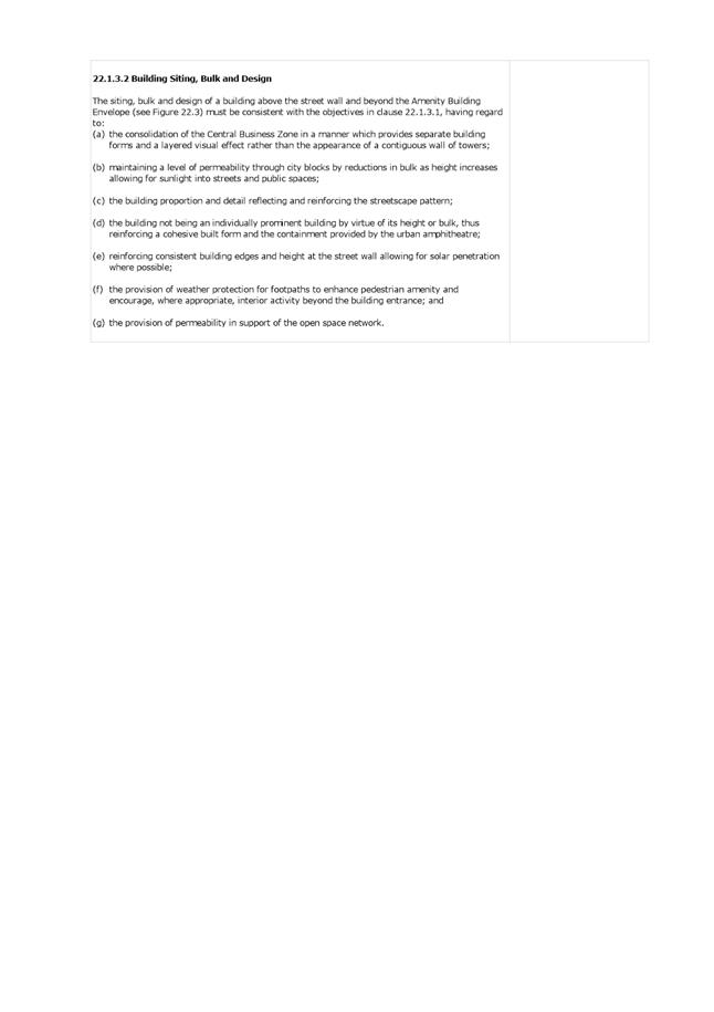
5.12. Reducing the Bulk - The Building Height Standards Review raised the important issue of reducing bulk as height increases together with the associated issue of permeability across the city and in between buildings. The Panel strongly supports this approach and the proposed amendment: which includes the following words:
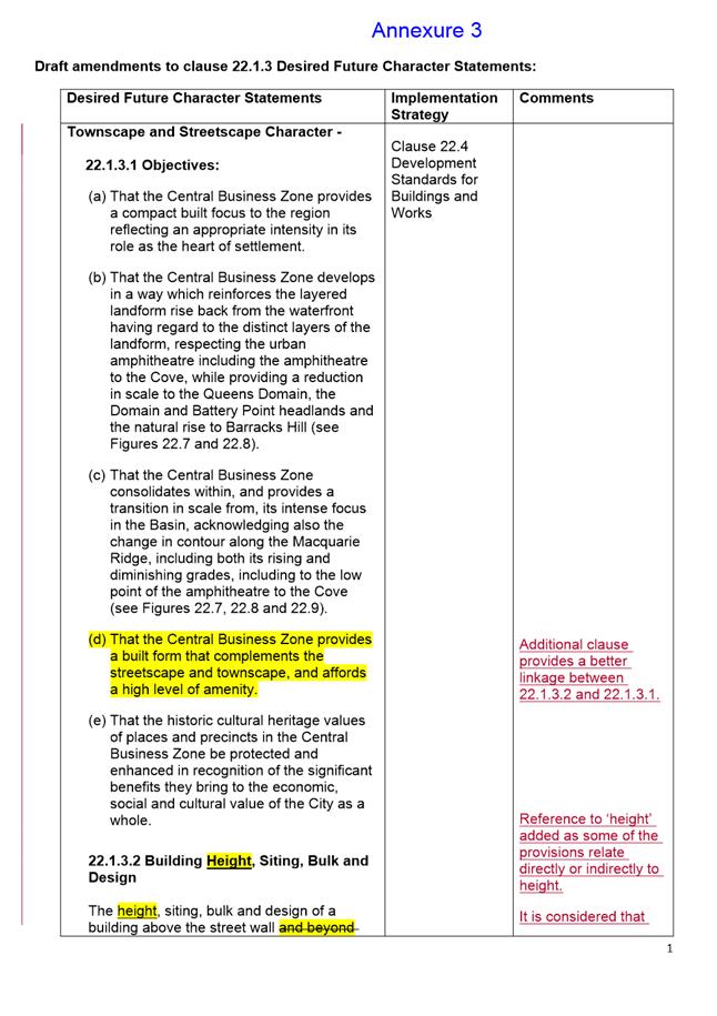
‘21.1.3.2 (b) maintaining a level of permeability through city blocks by reductions in bulk at each elevation as height increases allowing for sunlight into streets and public spaces.’
5.13. Reference to ‘Storey’ - The Panel noted that the reference to ‘storey’ as well as ‘height in the acceptable solutions creates some unnecessary confusion and inconsistency. The Panel considers the Planning Scheme provisions should rely on the reference to height only.
5.14. Roof Gardens - The Panel suggested a reference to roof gardens within the context of seeking improved roof-scapes as recommended in the Building Height Standards Review.
5.15. The Panel noted the Building Height Standards Review recognised the importance of designing taller buildings in ‘the round’ and the importance of roof gardens and raised the issue of urban rooftop gardens as an inclusion of clause 22.1.3.2 (i).
5.16. Urban Context Report - The Panel noted that the Building Height Standards Review refers to a number of urban design principles. These principles in the opinion of the Panel, are consistent with accepted urban design principles and protocols that when applied should lead to improved urban design outcomes.
5.17. The Panel therefore suggests that an urban context report be a fundamental submission requirement for applicants to ensure that relevant urban design townscape considerations are rigorously addressed. It suggests that it forms part of the application, when these issues are relevant.
5.18. The Panel considers that such a request for an Urban Context Report should be mandatory for all applications which seek discretion on height and that for all other applications where the Council deems appropriate.
5.19. Where Civic Amenities need to be provided in respect of discretionary development that goes beyond the Building Amenity Envelope, Clause 22.4.1 P1.2, be supplemented by a requirement in the Urban Context Report to address the benefits of the proposed civic amenities. This is suggested by the Panel to ensure that thorough consideration of those civic amenities appropriate to the local area is undertaken.
Draft Planning Scheme Amendments
5.20. The outcomes of the Building Height Standards Review is a comprehensive response to the project brief and is a significant body of work that adds considerably to the appreciation of the urban context of Hobart. The work builds on that undertaken by Leigh Woolley in 2016 in relation to the townscape and streetscape values of central Hobart and these are now identified in the Central Business Zone Desired Future Character Statement in the Hobart Interim Planning Scheme 2015.
5.21. The implementation of the height control planes and protection of important views through the planning scheme provisions will assist in maintaining the streetscape and townscape values of Central Hobart and Sullivans Cove and provide greater certainty and direction in the consideration of discretionary proposals.
5.22. The matters raised by the Urban Design Advisory Panel have generally been incorporated into the final draft of the proposed amendments provided in Attachment B.
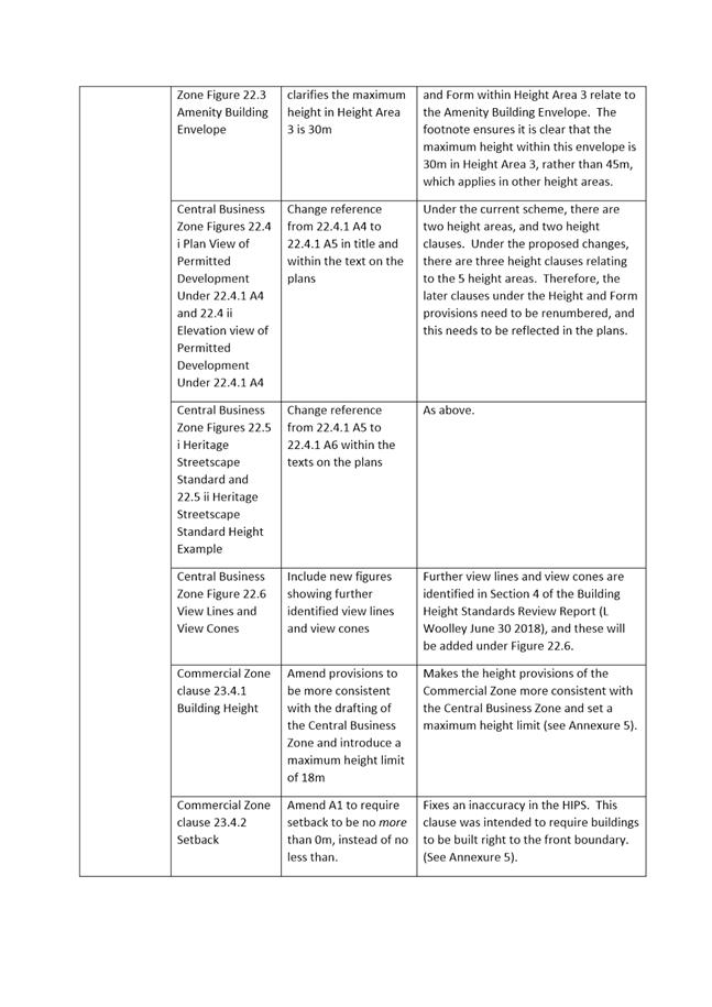
5.23. The proposed planning scheme amendments based on the outcomes of the Review are provided in Attachment B along with a summary and explanation of each amendment. The key amendments are outlined below:
5.24. In the Central Business Zone it is proposed that the height control planes be implemented by the designation of 5 Height Areas as shown on the map in Attachment C.
5.25. The boundaries of the height control planes have been modified in order to simplify implementation and take account of streets, property boundaries, zone boundaries, existing development, heritage constraints and the boundary of the Sullivans Cove Planning Scheme 1997. The overall intent of the recommended height control planes has however been maintained.
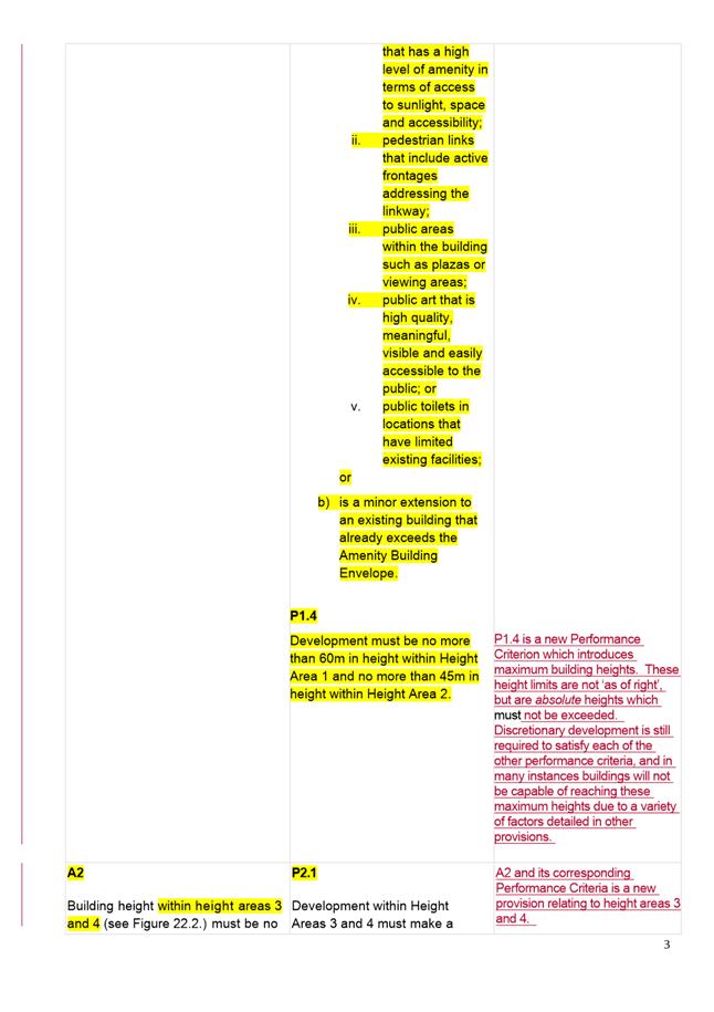
5.26. As indicated in the summary table in Attachment C, for each of Height Areas 1 to 5 an acceptable solution (permitted) maximum height is specified along with a suggested absolute maximum height that would be contained in the performance criteria. These range from 18m in Height Area 5 to 60m in Height Area 1. The Height Areas would be included in the Planning Scheme in a new Figure 22.2.
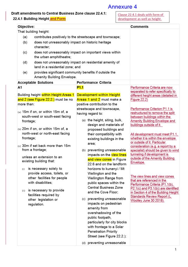
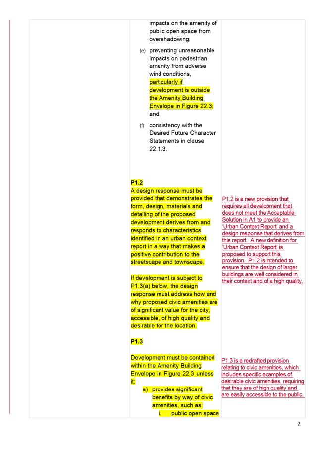
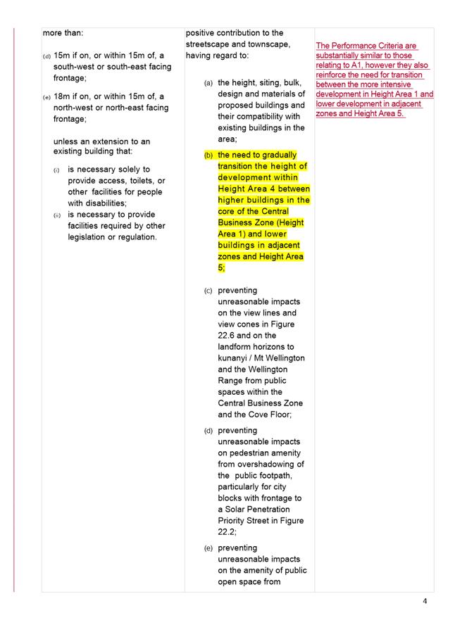
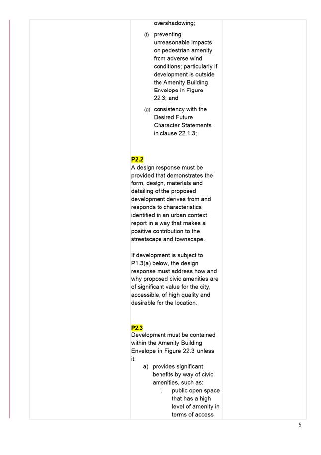
5.27. The performance criteria for the Height Areas are included in an amended clause 22.4.1 and require consideration of compatibility with existing buildings in the area, preventing unreasonable impacts on identified views, overshadowing of Pedestrian Priority Streets, overshadowing of public open space, adverse wind conditions and consistency with the Desired Future Character Statements in clause 22.1.3.
5.28. The performance criteria for Height Areas 1 to 4 also require that a design response must be provided that demonstrates the form, design, materials and detailing of the proposed development derives from and responds to characteristics identified in an urban context report in a way that makes a positive contribution to the streetscape and townscape. In addition development outside the amenity building envelope must provide significant civic amenities.
5.29. In Height Area 4 the performance criteria also requires a transition in the height of development within Height Area 4 between higher buildings in the inner core of the Central Business Zone (Height Area 1) and lower buildings in adjacent zones and Height Area 5. In Height Area 4 the absolute height limit proposed is 45m or 21m if within 50m of land within Height Area 5 or the Commercial Zone.
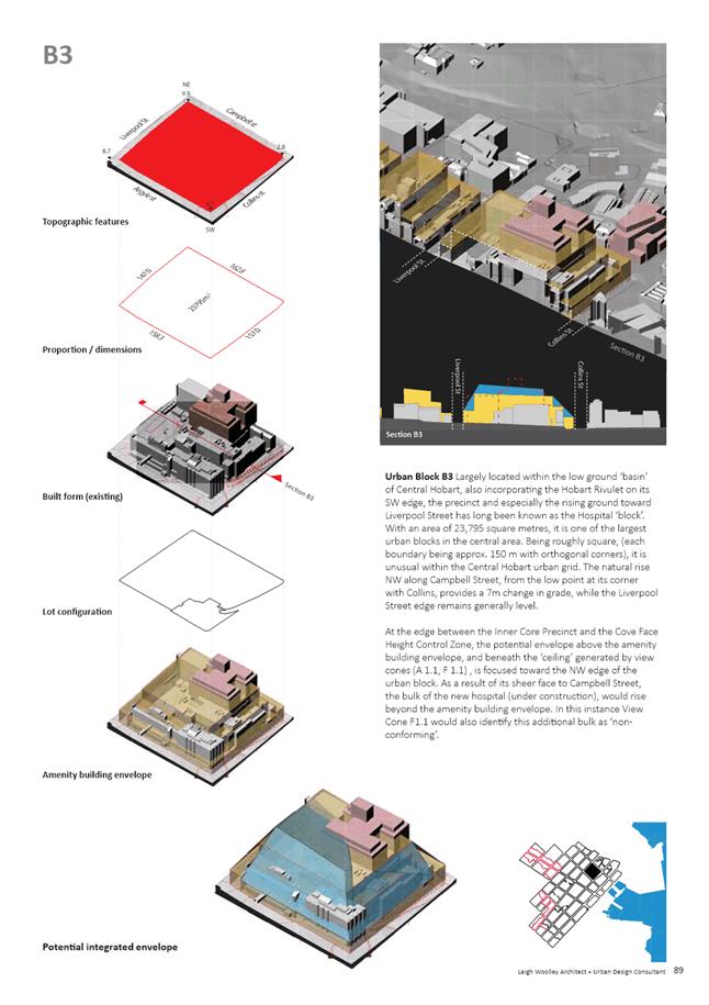
5.30. In the inner core of the Central Business Zone (Height Area 1) the suggested absolute maximum height is 60m. This is based on a detailed block by block analysis (see Attachment D) taking into account; topography, existing development, lot size and arrangement and heritage constraints. It is clear that in many circumstances, the maximum potential height as modelled in the Building Height Standards Review would not be able to be practically achieved.
5.31. The Central Business Zone clause 22.1.3 Desired Future Character Statements is proposed to be amended so that the statements reflect the Review outcomes and ensure the statements are considered for all developments discretionary for height, not just those outside the Amenity Building Envelope. A definition of ‘urban context report’ is also proposed to be included in clause 4.1.
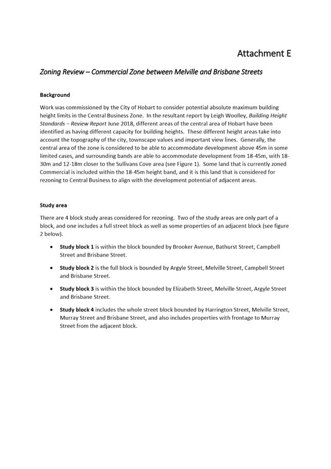
5.32. It is also proposed that the sites currently zoned Commercial between Melville and Brisbane Streets be rezoned to Central Business. The types of uses encouraged in the Commercial Zone such as bulky goods sales are not considered the most desirable for this location on the fringe of the CBD. The Central Business Zone will more accurately reflect the current uses on the blocks and will generally allow for increased development potential in a well located and well serviced area on the fringe of the CBD. A detailed assessment of the appropriate zoning of this area is provided in Attachment E.
5.33. The current HIPS2015 Central Business Zone provisions related to development standards for buildings are provided in Attachment F.
Commercial Zone
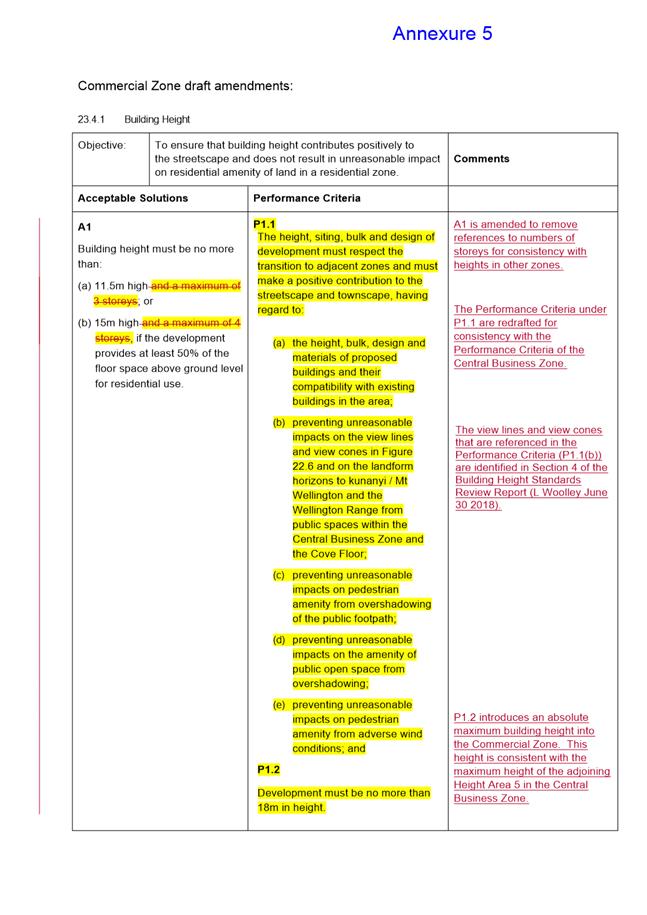
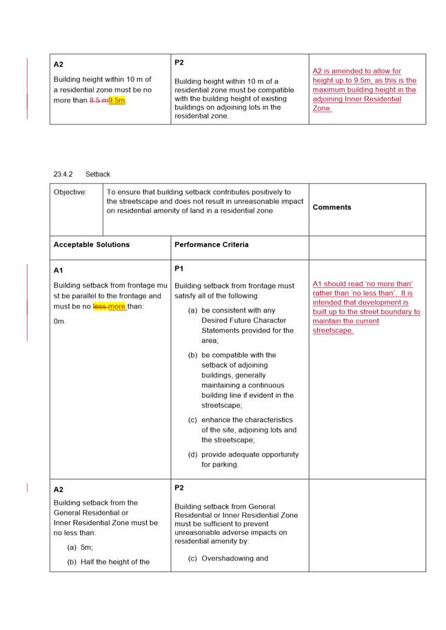
5.34. The proposed amendments to the Commercial Zone clause 23.4.1 Building Height are intended to make the height provisions of the Commercial Zone more consistent with the Central Business Zone and also set an absolute maximum height limit of 18m. The permitted height in this zone is 11.5m or 15m if the development provides at least 50% of the floor space above ground level for residential use.
Urban Mixed Use Zone
5.35. In the Urban Mixed Use Zone clause 15.4.1 Building Height P1 and P2 it is proposed to insert an absolute maximum building height of 15m for the whole of the Urban Mixed Use Zone in order to provide a transition in height from the Inner Residential Zone. The permitted height in this zone is 10m.
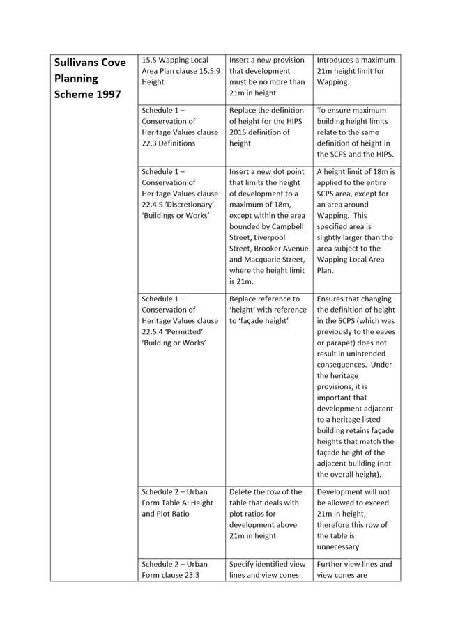
Sullivans Cove Planning Scheme 1997
5.36. The SCPS Wapping Local Area Plan clause 15.5.9 Height is proposed to be amended to introduce an absolute maximum height of 21m for Wapping which is currently the highest ‘deemed to comply’ (permitted) height under the Wapping Local Area Plan. Maximum heights in the Macquarie Point Site Development Plan area are yet to be determined as the Master Plan is currently under review.
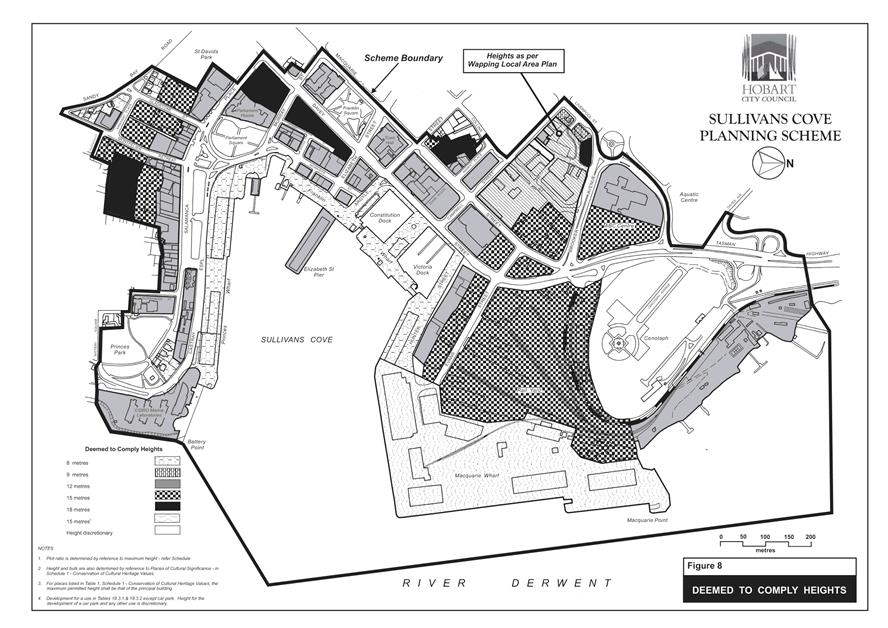
5.37. It is proposed that Schedule 2 Urban Form clause 23.6.2 ‘Discretionary’ Buildings be amended to include an absolute maximum height of 18m for the remainder of the SCPS. 18m is currently the highest ‘deemed to comply’ (permitted) height under clause 23.6.1 A and Figure 8 Deemed to Comply Heights (Attachment G). No change is proposed to the permitted heights.
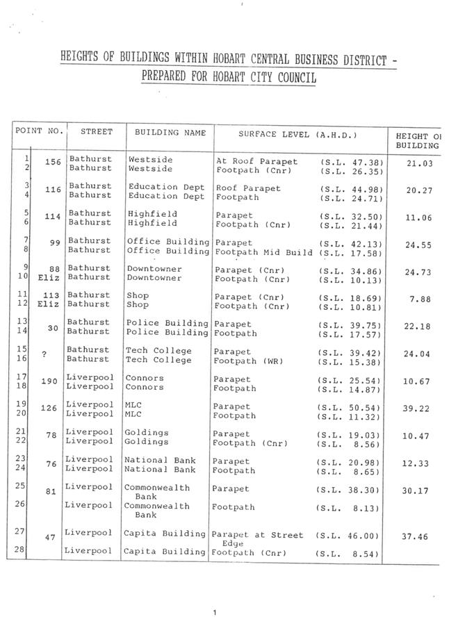
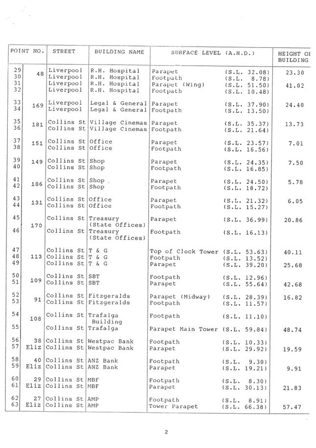
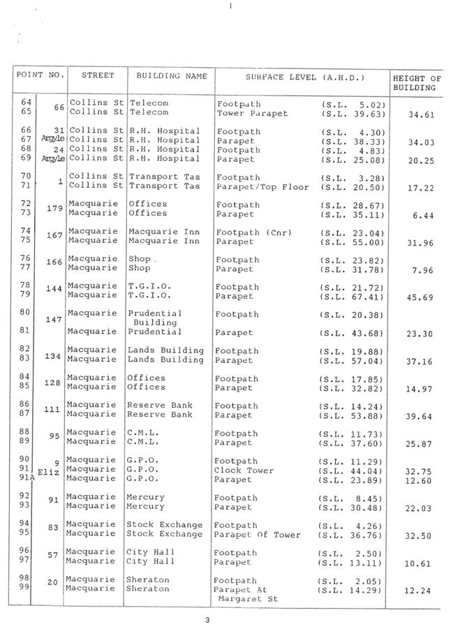
Examples of building heights
5.38. Examples of some existing building heights in central Hobart are provided in Attachment H in order to provide an appreciation of the various heights discussed in this report. The highest building in the CBD is currently the building on the south east corner of Elizabeth and Collins Streets which is 57.47m. The new RHH building currently under construction will be the highest building when completed at around 68m.
6. Strategic Planning and Policy Considerations
6.1. The proposed planning scheme amendments will assist in the achievement of the strategic objectives of the Capital City Strategic Plan 2015-2025 particularly in relation to Goal 2 Urban Management - 2.3 "City and regional planning ensures quality design, meets community needs...."
6.2. The implementation of the outcomes of the Building Height Standards Review is consistent with; Hobart: A community vision for our island capital, particularly in relation to the statements in Pillar 1. Sense of Place and Pillar 7. Built Environment.
7. Financial Implications
7.1. Funding Source and Impact on Current Year Operating Result
7.1.1. None.
7.2. Impact on Future Years’ Financial Result
7.2.1. None.
7.3. Asset Related Implications
7.3.1. None.
8. Legal, Risk and Legislative Considerations
8.1. Any future planning scheme amendments would be considered under the provisions of the Land Use Planning and Approvals Act 1993 (LUPAA) which requires planning scheme amendments to further the objectives of Schedule 1 of the Act and be prepared in accordance with State Policies.
9. Community and Stakeholder Engagement
9.1. It is proposed the Building Height Standards Review (L Woolley, 30 June 2018) report and the suggested planning scheme amendments in response be subject to a community and stakeholder engagement process prior to any decision being made on its implementation. The engagement process will include a public forum and stakeholder briefings to outline the proposed amendments and the results of the Building Height Standards Review.
10. Delegation
10.1. This matter is delegated to the Council.
As signatory to this report, I certify that, pursuant to Section 55(1) of the Local Government Act 1993, I hold no interest, as referred to in Section 49 of the Local Government Act 1993, in matters contained in this report.
|
James McIlhenny Manager Planning Policy & Heritage |
Neil Noye Director City Planning |
Date: 16 August 2018
File Reference: F18/88963; 17/167
Attachment a: Building
Height Review Report - L Woolley June 2018 ⇩ ![]()
Attachment
b: Building
Height Review Draft Amendments ⇩ ![]()
Attachment
c: Height
Areas Map ⇩ ![]()
Attachment
d: City
Block Analysis for Height Limits ⇩ ![]()
Attachment
e: Central
Business Zone Extension Assessment ⇩ ![]()
Attachment
f: HIPS
Central Business Zone Provisions ⇩ ![]()
Attachment
g: Sullivans
Cove Planning Scheme Heights ⇩ ![]()
Attachment
h: Building
Height Examples ⇩ ![]()
|
Item No. 8.1 |
Agenda (Open Portion) City Planning Committee Meeting - 27/8/2018 |
Page 337 ATTACHMENT a |


|
Agenda (Open Portion) City Planning Committee Meeting - 27/8/2018 |
Page 444 ATTACHMENT b |
|
Item No. 8.1 |
Agenda (Open Portion) City Planning Committee Meeting - 27/8/2018 |
Page 448 ATTACHMENT b |
|
Item No. 8.1 |
Agenda (Open Portion) City Planning Committee Meeting - 27/8/2018 |
Page 449 ATTACHMENT b |


|
Item No. 8.1 |
Agenda (Open Portion) City Planning Committee Meeting - 27/8/2018 |
Page 471 ATTACHMENT c |
|
Agenda (Open Portion) City Planning Committee Meeting - 27/8/2018 |
Page 472 ATTACHMENT d |
|
Agenda (Open Portion) City Planning Committee Meeting - 27/8/2018 |
Page 486 ATTACHMENT e |
|
Agenda (Open Portion) City Planning Committee Meeting - 27/8/2018 |
Page 494 ATTACHMENT f |
|
Agenda (Open Portion) City Planning Committee Meeting - 27/8/2018 |
Page 513 ATTACHMENT g |
|
Agenda (Open Portion) City Planning Committee Meeting - 27/8/2018 |
Page 514 ATTACHMENT h |
|
Agenda (Open Portion) City Planning Committee Meeting |
Page 520 |
|
|
|
27/8/2018 |
|
8.2 Dr Edward Hall Grants 2018
Report of the Environmental & Climate Change Projects Officer and the Acting Director City Planning of 22 August 2018 and attachment.
Delegation: Committee
|
Item No. 8.2 |
Agenda (Open Portion) City Planning Committee Meeting |
Page 521 |
|
|
27/8/2018 |
|
REPORT TITLE: Dr Edward Hall Grants 2018
REPORT PROVIDED BY: Environmental & Climate Change Projects Officer
Acting Director City Planning
1. Report Purpose and Community Benefits
1.1. This purpose of this report is to:
1.1.1. Recommend to the City Planning Committee the allocation of funds through the 2018 Dr Edward Hall Environment Grants, Round 8;
1.1.2. Advise that the current 2018 Dr Edward Hall Environment Grant, Round 8, was administered by the Community and Culture Division’s Grants Officer, using the Smarty Grants platform and enabling alignment to other Council grant’s processes; with expert and technical input from City Planning; and
1.1.3. Also advise that the Dr Edward Hall Environment Grants are slated for review which is the subject of a separate report to the Finance and Governance Committee.
2. Report Summary
2.1. The City’s Dr Edward Hall Environment Grants program encourages applications from across the City’s municipal area for urban sustainability, resilience and environment initiatives. It is under the auspices of the City Planning Division and is open to schools (primary, secondary and colleges), community groups and businesses for grants between $500 and $5000.
2.2. To date, a total of 54 projects have been funded, through the previous 7 rounds, with approximately $200,000 being dispensed to the community for urban sustainability related projects. These funds supported projects valued at over $500,000 across the community (subject to final acquittal of ‘live’ grants).
2.3. Delegation is provided to the City Planning Committee to approve the Grants funding allocations following consideration of recommendations from the Dr Edward Hall Environment Grants Assessment Panel. (Please see Table 2 for panel membership).
2.4. The 2018 Grants received 9 grant applications requesting $39,065 for projects totalling $124,382 in overall project value. It is recommended that seven projects (please refer to Table 3) be funded at a total cost of $34,064, leveraging $103,634 of overall project value. A summary of these is contained in Table 3 of this report.
2.5. The high quality of the Grants applications continuing to be received reflects strong interest within the community for the initiative which assists in increasing urban sustainability and resilience.
2.6. Whilst the previous grant rounds have been administered by City Planning the current 2018 Grant, Round 8, along with the Waste Reduction Grants, were administered by the Community and Culture Division’s Grants Officer, using the Smarty Grants platform. This enabled better alignment to other council grants processes and more efficient access by applicants. City Planning still retains technical and expert input into the grants development and assessment.
2.7. The Grants are slated for review which is the subject of a separate report Finance and Governance Committee.
|
That the recommended level of funding to the respective applicants for assistance under the 2018 Dr Edward Hall Environment Grants, as outlined in Table 3 of this report, and totalling $34,064 be approved. |
4. Background
4.1. The annual Dr Edward Hall Environment Grants (the Grants) are within the remit of City Planning following its conversion from an award to an annual grant based program in 2010.
4.2. The Grants are currently slated for review which is the subject of a separate report to the Finance and Governance Committee.
4.3. To date, a total of 54 projects have been funded through the previous 7 rounds, with approximately $200,000 being dispensed to the community for urban sustainability related projects. These funds have supported projects valued at over $500,000 across the community.
4.4. The City Planning Committee has delegation to award the Grants following consideration of the recommendations from the Dr Edward Hall Environment Grants Assessment Panel. The General Manager has delegation to approve the Assessment Panel.
4.5. The Grants are open to schools (primary, secondary and colleges), community groups and business sectors for urban sustainability projects. A total of $35,000 is available, in the 2018 Grant round, for grants of between $500 and $5,000 in value.
4.6. The current 2018 Grant, Round 8, along with the City’s Waste Reduction Grants, were administered by the Community and Culture Division’s Grants Officer, utilising the Smarty Grants platform enabling more efficient access by applicants and aligning to other council grants processes. City Planning provided technical and expert input into the grants development and assessment.
2018 Dr Edward Hall Grants – Round 8
4.7. A total of 9 applications were received for the 2018 Grants. A summary of the grant applications received, funds sought and selection panel comments comprise Attachment A – Assessment Panel Outcomes of this report.
4.8. The total dollar value of funding sought in the 2018 Grants is $39,065. Table 1 details the aggregate amounts of funds sought across the categories of applicants.
5. Table 1. Summary of all applicant categories and funds sought in 2018 DEHEG R8
|
Category |
No. of Applications |
Funds sought |
Total Project Value |
|
School (Primary, Secondary and Colleges) |
5 |
$14,065 |
$36,023 |
|
Not for profit |
3 |
$20,000 |
$75,609 |
|
Business |
1 |
$5,000 |
$12,750 |
|
Total |
|
$39,065 |
$124,382 |
5.1. The Assessment Panel members and their areas of expertise are outlined in the following: Table 2 DEHEG Assessment Panel Members.
6. Table 2: DEHEG Assessment Panel Members
|
Name |
Area of expertise |
Organisation |
|
Maree Bakker |
Environment and Sustainability Officer, EPA Division, DPIPWE |
EPA Division, DPIPWE |
|
Jess Dwyer |
Environmental Health Officer, City Planning |
CoH |
|
Kimbra Parker |
Acting Associate Director Community and Culture |
CoH |
|
Tony Bonney |
Community Activation Coordinator |
CoH |
|
Sophia Newman |
Waste Education Officer, Parks and City Amenity |
CoH |
|
Observers: |
|
|
|
Jeff Holmes |
Cleansing & Solid Waste Policy Coordinator, Parks and City Amenity, City of Hobart |
CoH |
|
Katrina Graham |
Environment and Climate Change Officer |
CoH |
6.1. The Assessment Panel assessed each of the 7 applications in relation to the Assessment Criteria for Eligible Projects contained in the Grants Guidelines as follows:
6.1.1. Aligns with the City of Hobart’s Capital City Strategic Plan 2015 - 2025 in relation to Goal 2 Urban Management and Goal 3 Environment and Natural Resources.
6.1.2. Respond to demonstrated needs and concerns of the community.
6.1.3. Conserve, protect and enhance the natural environment including waterways, coasts and bush land areas.
6.1.4. Improve and enhance the sustainability of the built environment and local communities.
6.1.5. Increase: energy efficiency, reduce greenhouse gases emissions, improve water and air quality, urban food security, sustainable transport opportunities and recycling.
6.1.6. Produce innovative outcomes which benefit local communities, the built environment and the natural environment.
6.1.7. For activities which are to be ongoing, have the capacity to develop self-sustainability.
7. Proposal and Implementation
7.1. It is proposed that the applications, in the following table, be funded under the 2018 Grants Round 8:
8. Table 3: DEHEG Grant Applications 2018 recommended for funding
|
Applicant |
Project Title |
Total Amount Request |
Total Project Value |
Themes |
Brief Project Description |
|
Sustainable Living Tasmania Inc |
Shine Again - Facilitating solar panel reuse and recycling in the shadow of the legacy feed-in tariff |
$5,000 |
$10,109 |
Waste Diversion and Reuse Education Awareness
Energy Efficiency and Renewable Energy,
Sustainable Behaviour |
Hundreds of kilowatts of solar panels will likely be removed from Hobart rooftops around when the legacy feed-in winds up at the end of 2018. This project will ensure as many of these panels as possible 'shine again' through re-use, or at least have precious materials in them properly recycled, thereby potentially avoiding gigawatt hours of forgone renewable electricity, thousands of tonnes of greenhouse gas emissions, and tonnes of glass and aluminium going to landfill. |
|
Greening Australia (Tas) Ltd |
Energy Futures Tiny House Fit Out |
$5,000 |
$25,500 |
Energy Efficiency and Renewable Energy Education Awareness |
The Energy Futures Tiny House is a mobile resource for community education events, including the Sustainability Expo, Youth Climate Change Conferences and visits to Hobart schools in support of the Energy Wise program for secondary school students. The Dr Edward Hall Grant will enable the fitting out of the Energy Futures Tiny House with renewable energy technology, interactive and static displays and learning materials to raise awareness of energy efficiency and renewable energy. It will provide a learning resource at its base at the Sustainability Learning Centre, Mt Nelson and in schools around Hobart. |
|
Australian Youth Climate Coalition (AYCC) |
Hobart Climate Justice Summit |
$5,000 |
$25,000 |
Climate change impacts, adaptation, resilience
Sustainable Behaviour, Education Awareness |
At the Hobart Climate Justice Summit, high school students will gain the skills and confidence they need to lead sustainability projects in their community. The Australian Youth Climate Coalition (AYCC) staff and volunteers will use their unique peer-to-peer model to engage students with climate science and solutions. Students will hear inspiring and educational talks from scientists and humanitarians, and participate in hands-on workshops to build skills in leadership and organising. Through the Hobart Climate Justice Summit, students will be empowered to lead projects that reduce pollution and greenhouse emissions and help build a community that is resilient to climate change. |
|
Sustainability Learning Centre @Hobart College Department of Education Tasmania |
Inside Outside |
$5,000 |
$10,710 |
Biodiversity and Natural Environment,
Sustainable Behaviour,
Community Sustainability Event,
Education Awareness |
Showing inside activities to the wider community, outside the box. To understand the current species living on Mt Nelson and surrounding Hobart College (HC) the Inside/Outside project aims to install different nesting boxes to enhance the breeding habitat and determine specific species that will accept nesting boxes, with the final outcome of education & enhancing biodiversity. Peeper (nest box inspection) and night vision camera footage will explicitly capture behaviour/species breeding inside the nesting boxes which will educate students, Bushcare volunteers, community and conservation scientists. The launch of the youth directed Inside/Outside documentary will inform a community biodiversity forum. |
|
Salamanca Arts Centre |
Seed Garden (Development) |
$5,000 |
$15,000 |
Biodiversity and Natural Environment,
Sustainable Behaviour |
Salamanca Arts Centre (SAC) will commence the delivery of a collaborative urban garden design project that utilises the concrete chess-board area (that sits adjacent to Salamanca Square) to create an inviting meeting place - a hidden pocket garden that is adaptable, refreshing and playfully innovative. This project will enhance the environmental, social, economic and aesthetic components of the space and its surrounds. The design of the space will be subtle and contemporary, to create an ideal shared area for visitors and locals to relax and enjoy the heritage buildings in the vicinity. |
|
Island Magazine Inc. |
Writing the future: imagining climate change, adaptation and resilience |
$5,000 |
$12,750 |
Climate change impacts, adaptation, resilience |
Island Magazine will invite Tasmanian writers to respond creatively to the Hobart City Council’s 'Hobart Climate Change Information for Decision Making'. Artistic imaginative response enables exploration and communication of the impacts of a changing climate and possible adaptations. It helps to transform ‘theoretical’ concepts into realised scenarios, deepening community awareness and engagement. Three selected pieces of creative nonfiction or fiction will be published in Island, and later be permanently and freely available online. The project will culminate in a free public event in Hobart in which the authors will discuss their responses to imagined climate futures. |
|
Lansdowne Crescent Primary School Community Association |
Aqua Bubbler Drinking Fountain |
$4,065 |
$4,565 |
Waste Diversion and Reuse,
Community Sustainability Event, Education Awareness |
We would like to install an Aqua Bubbler water fountain on Lansdowne Crescent Primary School grounds. The 400 children at the primary school have access to clean drinking water during daily activities, so they will keep hydrated, not rely on fruit juice or other drinks, and be healthy. They will also be able to reuse existing water bottles rather than buying pre-packaged drinks. The wider community that visits the school will also be able to use the water fountain. School and sporting events will be catered for with fresh water from the fountain. |
9. Strategic Planning and Policy Considerations
9.1. This initiative responds to and furthers the City of Hobart’s Capital City Strategic Plan 2015 - 2025 in relation to Goal 2 Urban Management and Goal 3 Environment and Natural Resources.
10. Financial Implications
10.1. Funding Source and Impact on Current Year Operating Result
10.1.1. A total of $35,000 is available for grants of between $500 and $5,000 from the Community and Culture DEHEG budget allocation. (NB the budget allocation has been transferred from the City Planning’s budget to align with the grants delivery by Community and Culture using the Smarty grants platform).
10.1.2. The Grant applications received sought a total of $39,065 for projects totalling $124,382. Seven grants were identified by the Assessment Panel for funding totalling $39,065, subject to endorsement of the City Planning Committee.
10.2. Impact on Future Years’ Financial Result
10.2.1. None.
10.3. Asset Related Implications
10.3.1. None.
11. Legal, Risk and Legislative Considerations
11.1. There are no legal, risk of legislative requirements associated with the Grants.
12. Environmental Considerations
12.1. The Grants directly address urban sustainability considerations within Hobart’s municipal area including: climate change, energy efficiency, renewables, water quality and use, food gardens, air quality, local transport, waste considerations and increasing community awareness, knowledge, participation and resilience.
13. Marketing and Media
13.1. It is intended that the Grant recipients be promoted:
13.1.1. In a community notice in The Mercury newspaper;
13.1.2. On the Council’s website; and
13.1.3. In the next edition of Capital City News.
14. Delegation
14.1. The City Planning Committee has delegation to award the Grants funding following consideration of recommendations from the Dr Edward Hall Environment Grants Assessment Panel. This is reflected in the amended City Planning Committee’s Terms of Reference.
14.2. No additional delegations are considered necessary at this time.
As signatory to this report, I certify that, pursuant to Section 55(1) of the Local Government Act 1993, I hold no interest, as referred to in Section 49 of the Local Government Act 1993, in matters contained in this report.
|
Katrina Graham Environmental & Climate Change Projects Officer |
James McIlhenny Acting Director City Planning |
Date: 22 August 2018
File Reference: F18/93786
Attachment a: Assessment
Panel Outcomes ⇩ ![]()
|
Item No. 8.2 |
Agenda (Open Portion) City Planning Committee Meeting - 27/8/2018 |
Page 528 ATTACHMENT a |
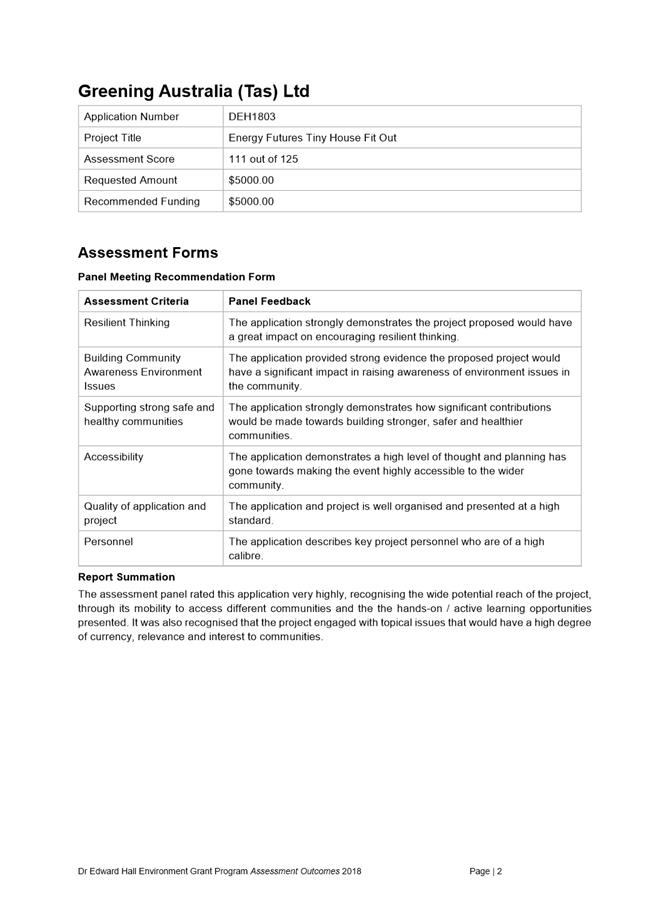
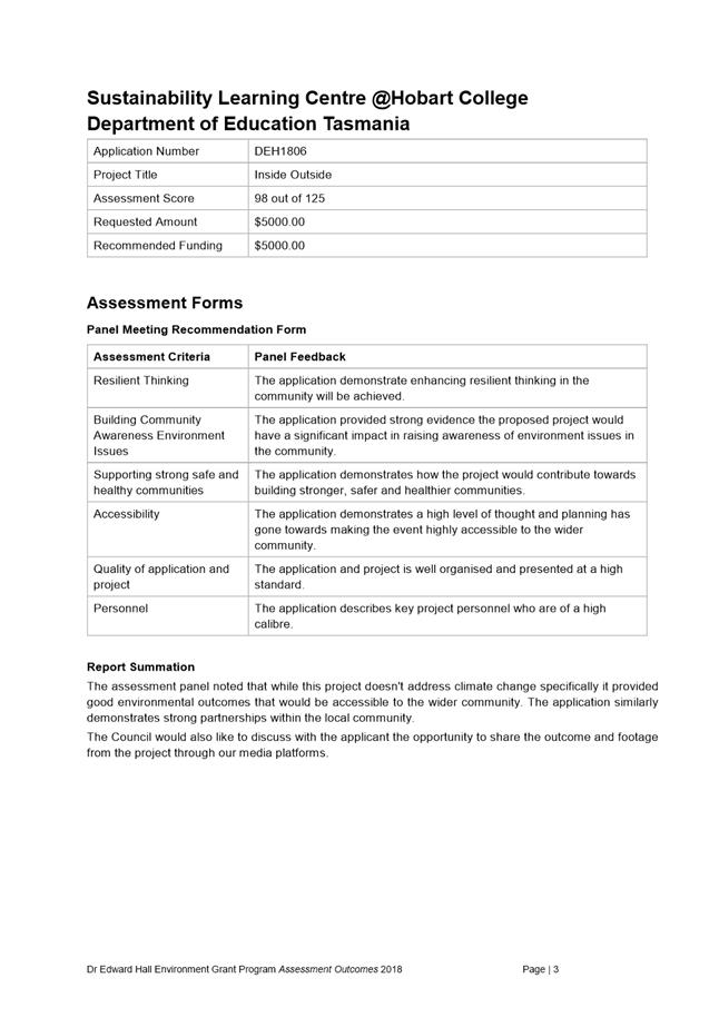
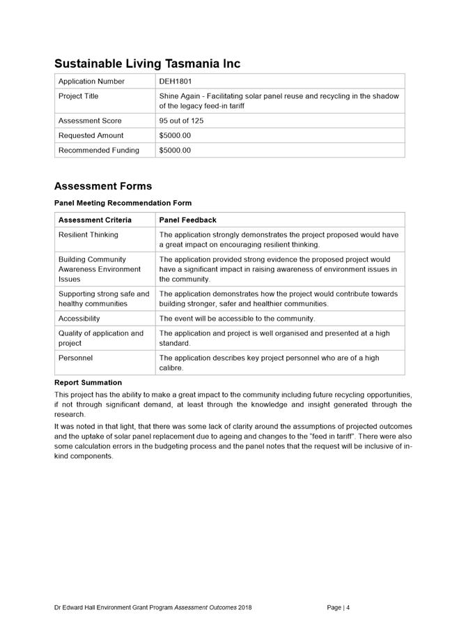
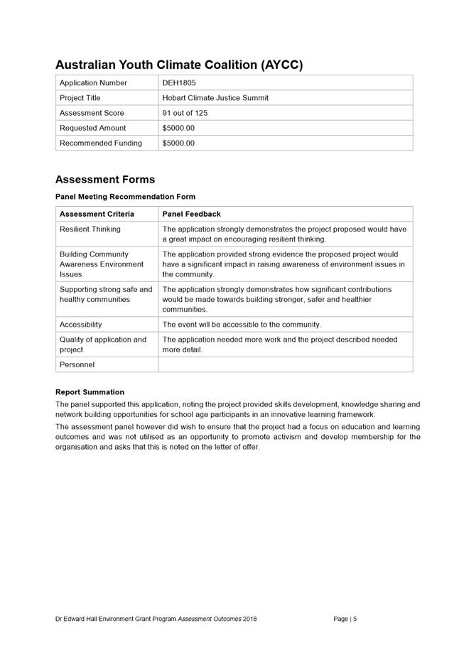
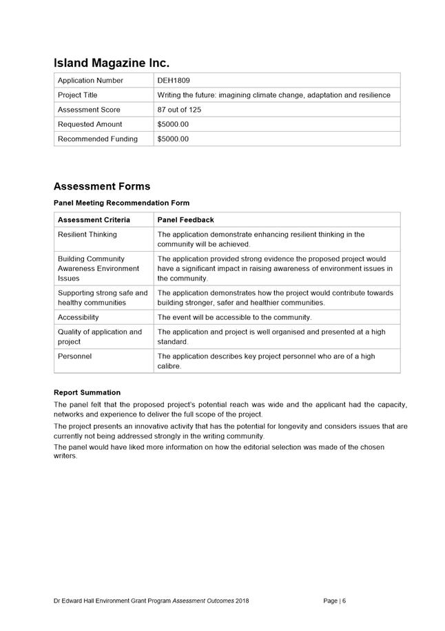
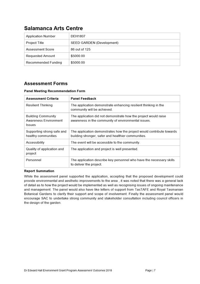
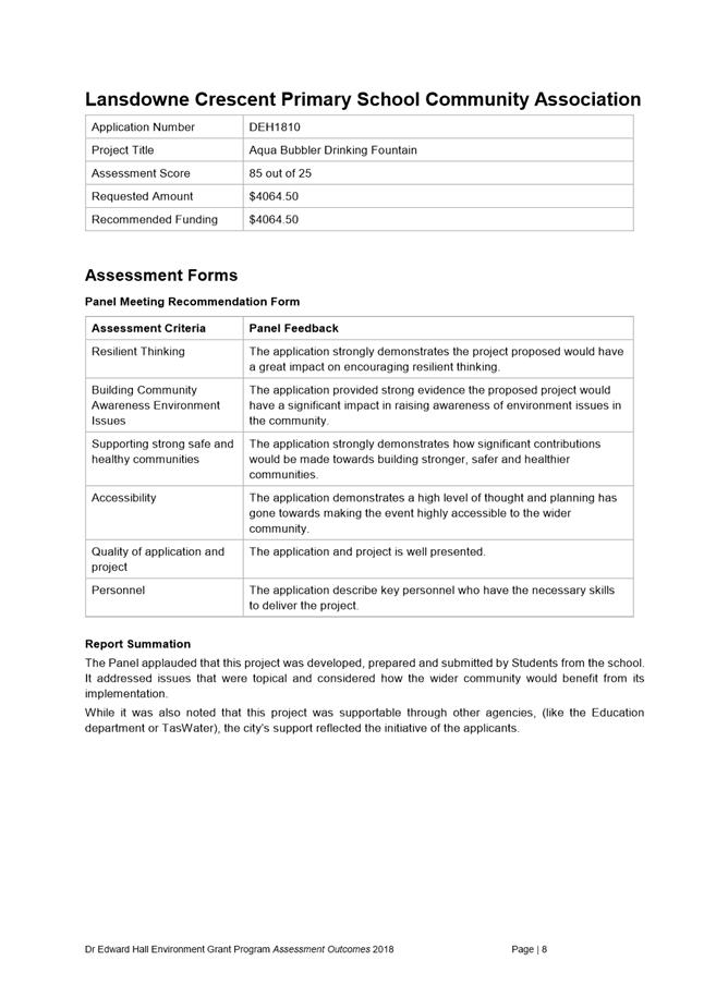
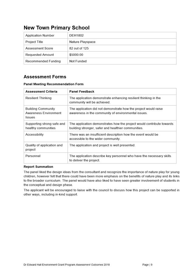
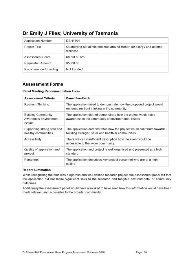
|
Agenda (Open Portion) City Planning Committee Meeting |
Page 538 |
|
|
|
27/8/2018 |
|
8.3 Delegated Decisions Report (Planning)
Memorandum of the Acting Director City Planning of 21 August 2018 and attachment.
Delegation: Committee
|
Item No. 8.3 |
Agenda (Open Portion) City Planning Committee Meeting |
Page 539 |
|
|
27/8/2018 |
|

Memorandum: City Planning Committee
Delegated Decisions Report (Planning)
Attached is the delegated planning decisions report for the period 6 August until 17 August 2018.
|
That the information contained in the memorandum titled ‘Delegated Decisions Report (Planning)’ of 21 August 2018 be received and noted. |
As signatory to this report, I certify that, pursuant to Section 55(1) of the Local Government Act 1993, I hold no interest, as referred to in Section 49 of the Local Government Act 1993, in matters contained in this report.
|
James McIlhenny Acting Director City Planning |
|
Date: 21 August 2018
File Reference: F18/94256
Attachment a: Delegated
Decisions Report (Planning) ⇩ ![]()
|
Item No. 8.3 |
Agenda (Open Portion) City Planning Committee Meeting - 27/8/2018 |
Page 540 ATTACHMENT a |
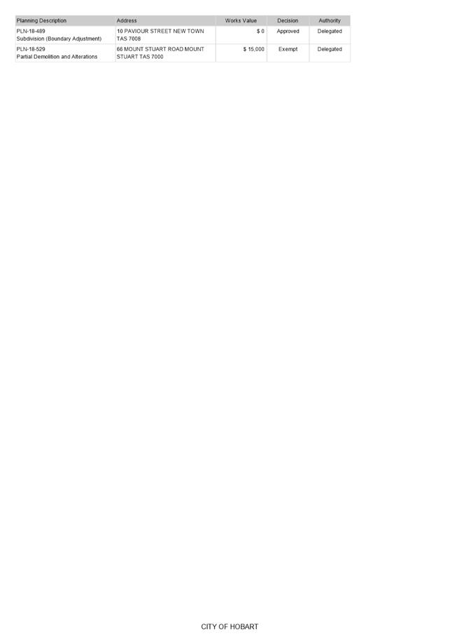
|
Agenda (Open Portion) City Planning Committee Meeting |
Page 542 |
|
|
|
27/8/2018 |
|
8.4 City Planning - Advertising Report
Memorandum of the Acting Director City Planning of 22 August 2018 and attachment.
Delegation: Committee
|
Item No. 8.4 |
Agenda (Open Portion) City Planning Committee Meeting |
Page 543 |
|
|
27/8/2018 |
|

Memorandum: City Planning Committee
City Planning - Advertising Report
Attached is the advertising list for the period 4 August 2018 until 17 August 2018.
|
That the information contained in the memorandum titled ‘City Planning – Advertising Report’ of 22 August 2018 be received and noted.
|
As signatory to this report, I certify that, pursuant to Section 55(1) of the Local Government Act 1993, I hold no interest, as referred to in Section 49 of the Local Government Act 1993, in matters contained in this report.
|
James McIlhenny Acting Director City Planning |
|
Date: 22 August 2018
File Reference: F18/94353
Attachment a: City
Planning - Advertising Report ⇩ ![]()
|
Item No. 8.4 |
Agenda (Open Portion) City Planning Committee Meeting - 27/8/2018 |
Page 544 ATTACHMENT a |
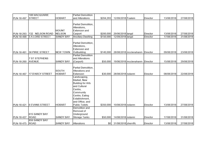
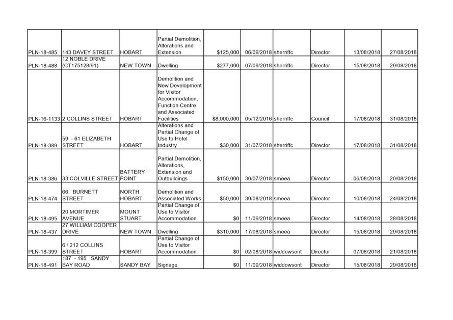
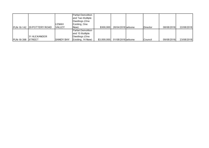
|
|
Agenda (Open Portion) City Planning Committee Meeting |
Page 549 |
|
|
27/8/2018 |
|
Section 29 of the Local Government (Meeting Procedures) Regulations 2015.
File Ref: 13-1-10
An Alderman may ask a question without notice of the Chairman, another Alderman, the General Manager or the General Manager’s representative, in line with the following procedures:
1. The Chairman will refuse to accept a question without notice if it does not relate to the Terms of Reference of the Council committee at which it is asked.
2. In putting a question without notice, an Alderman must not:
(i) offer an argument or opinion; or
(ii) draw any inferences or make any imputations – except so far as may be necessary to explain the question.
3. The Chairman must not permit any debate of a question without notice or its answer.
4. The Chairman, Aldermen, General Manager or General Manager’s representative who is asked a question may decline to answer the question, if in the opinion of the respondent it is considered inappropriate due to its being unclear, insulting or improper.
5. The Chairman may require a question to be put in writing.
6. Where a question without notice is asked and answered at a meeting, both the question and the response will be recorded in the minutes of that meeting.
7. Where a response is not able to be provided at the meeting, the question will be taken on notice and
(i) the minutes of the meeting at which the question is asked will record the question and the fact that it has been taken on notice.
(ii) a written response will be provided to all Aldermen, at the appropriate time.
(iii) upon the answer to the question being circulated to Aldermen, both the question and the answer will be listed on the agenda for the next available ordinary meeting of the committee at which it was asked, where it will be listed for noting purposes only.
|
|
Agenda (Open Portion) City Planning Committee Meeting |
Page 550 |
|
|
27/8/2018 |
|