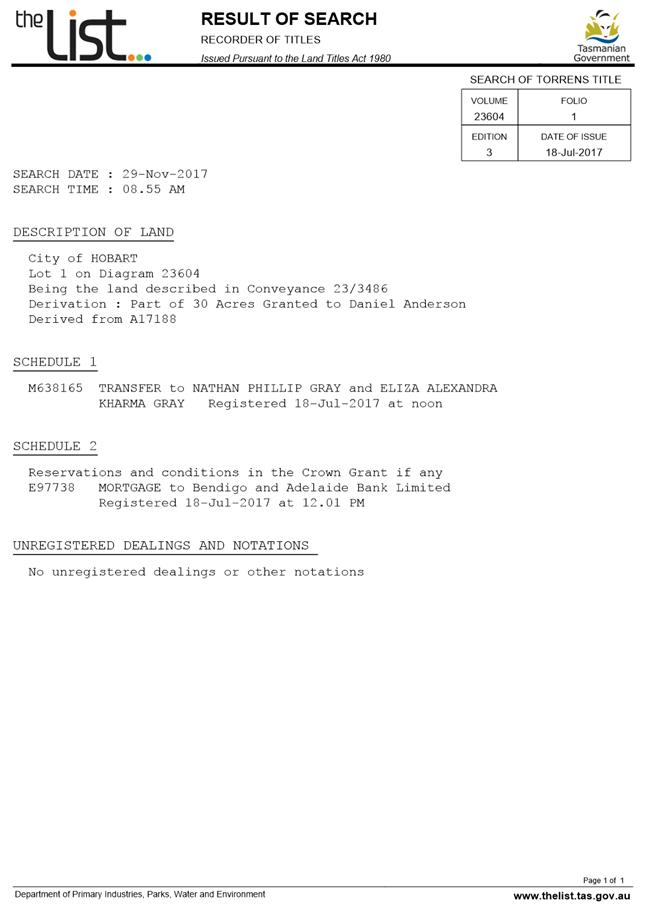
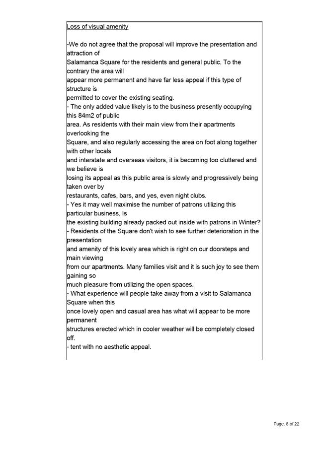
City
of hobart
AGENDA
City Planning Committee Meeting
Open Portion
Monday, 24 June 2019
at 5:00 pm
Lady Osborne Room, Town Hall
City
of hobart
AGENDA
City Planning Committee Meeting
Open Portion
Monday, 24 June 2019
at 5:00 pm
Lady Osborne Room, Town Hall
THE MISSION
Our mission is to ensure good governance of our capital City.
THE VALUES
The Council is:
|
about people |
We value people – our community, our customers and colleagues. |
|
professional |
We take pride in our work. |
|
enterprising |
We look for ways to create value. |
|
responsive |
We’re accessible and focused on service. |
|
inclusive |
We respect diversity in people and ideas. |
|
making a difference |
We recognise that everything we do shapes Hobart’s future. |
|
|
Agenda (Open Portion) City Planning Committee Meeting |
Page 4 |
|
|
24/6/2019 |
|
Business listed on the agenda is to be conducted in the order in which it is set out, unless the committee by simple majority determines otherwise.
APOLOGIES AND LEAVE OF ABSENCE
1. Co-Option of a Committee Member in the event of a vacancy
3. Consideration of Supplementary Items
4. Indications of Pecuniary and Conflicts of Interest
6. Planning Authority Items - Consideration of Items With Deputations
7. Committee Acting as Planning Authority
7.1 Applications under the Sullivans Cove Planning Scheme 1997
7.2 Applications under the Hobart Interim Planning Scheme 2015
7.2.2 53 Hillcrest Road, Tolmans Hill and Adjacent Road Reserve - Dwelling
8.1 Central Hobart Precincts Plan - Project Brief
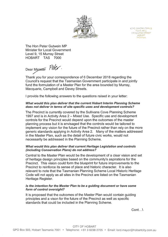
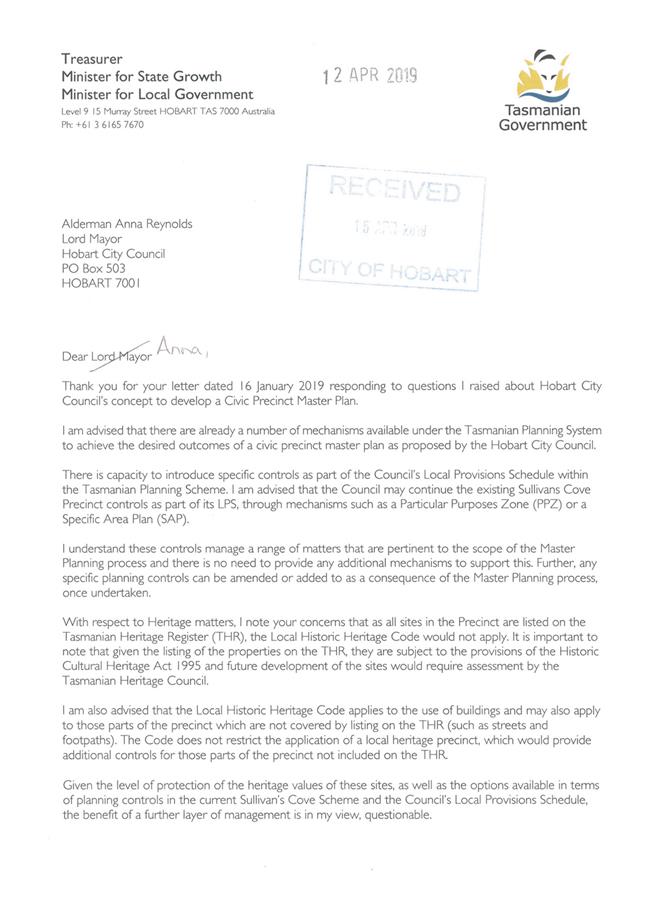
8.2 Civic Precinct Master Plan Proposal - Response from Minister
8.3 City Planning - Advertising Report
8.4 Delegated Decisions Report (Planning)
9 Committee Action Status Report
9.1 Committee Actions - Status Report
11. Closed Portion Of The Meeting
|
|
Agenda (Open Portion) City Planning Committee Meeting |
Page 6 |
|
|
24/6/2019 |
|
City Planning Committee Meeting (Open Portion) held Monday, 24 June 2019 at 5:00 pm in the Lady Osborne Room, Town Hall.
|
COMMITTEE MEMBERS Deputy Lord Mayor Burnet (Chairman) Briscoe Denison Harvey Behrakis
NON-MEMBERS Lord Mayor Reynolds Zucco Sexton Thomas Dutta Ewin Sherlock |
Apologies:
Leave of Absence: Nil.
|
|
The minutes of the Open Portion of the City Planning Committee meeting held on Tuesday, 11 June 2019, are submitted for confirming as an accurate record.
|
Ref: Part 2, Regulation 8(6) of the Local Government (Meeting Procedures) Regulations 2015.
|
That the Committee resolve to deal with any supplementary items not appearing on the agenda, as reported by the General Manager.
|
Ref: Part 2, Regulation 8(7) of the Local Government (Meeting Procedures) Regulations 2015.
Members of the Committee are requested to indicate where they may have any pecuniary or conflict of interest in respect to any matter appearing on the agenda, or any supplementary item to the agenda, which the committee has resolved to deal with.
Regulation 15 of the Local Government (Meeting Procedures) Regulations 2015.
A committee may close a part of a meeting to the public where a matter to be discussed falls within 15(2) of the above regulations.
In the event that the committee transfer an item to the closed portion, the reasons for doing so should be stated.
Are there any items which should be transferred from this agenda to the closed portion of the agenda, or from the closed to the open portion of the agenda?
In accordance with the requirements of Part 2 Regulation 8(3) of the Local Government (Meeting Procedures) Regulations 2015, the General Manager is to arrange the agenda so that the planning authority items are sequential.
In accordance with Part 2 Regulation 8(4) of the Local Government (Meeting Procedures) Regulations 2015, the Committee by simple majority may change the order of any of the items listed on the agenda, but in the case of planning items they must still be considered sequentially – in other words they still have to be dealt with as a single group on the agenda.
Where deputations are to be received in respect to planning items, past practice has been to move consideration of these items to the beginning of the meeting.
RECOMMENDATION
That in accordance with Regulation 8(4) of the Local Government (Meeting Procedures) Regulations 2015, the Committee resolve to deal with any items which have deputations by members of the public regarding any planning matter listed on the agenda, to be taken out of sequence in order to deal with deputations at the beginning of the meeting.
|
|
Agenda (Open Portion) City Planning Committee Meeting |
Page 7 |
|
|
24/6/2019 |
|
In accordance with the provisions of Part 2 Regulation 25 of the Local Government (Meeting Procedures) Regulations 2015, the intention of the Committee to act as a planning authority pursuant to the Land Use Planning and Approvals Act 1993 is to be noted.
In accordance with Regulation 25, the Committee will act as a planning authority in respect to those matters appearing under this heading on the agenda, inclusive of any supplementary items.
The Committee is reminded that in order to comply with Regulation 25(2), the General Manager is to ensure that the reasons for a decision by a Council or Council Committee acting as a planning authority are recorded in the minutes.
|
Agenda (Open Portion) City Planning Committee Meeting |
Page 9 |
|
|
|
24/6/2019 |
|
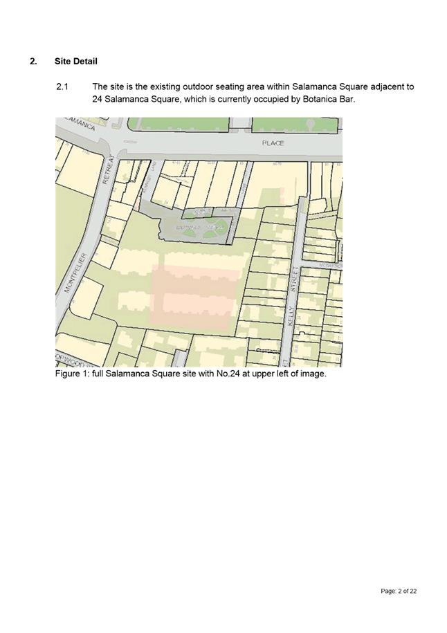
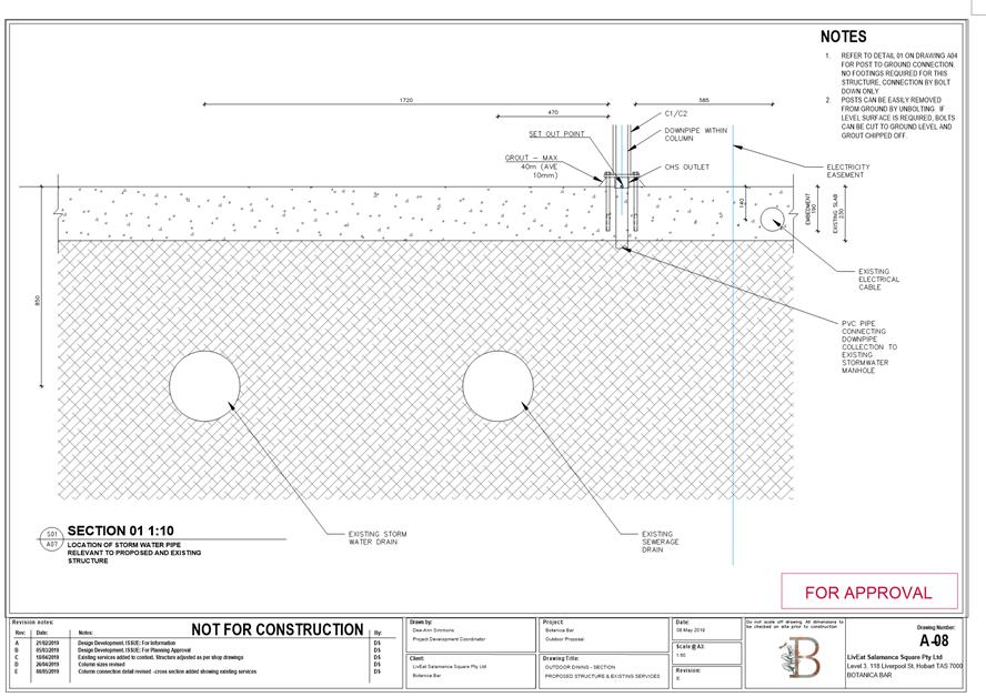
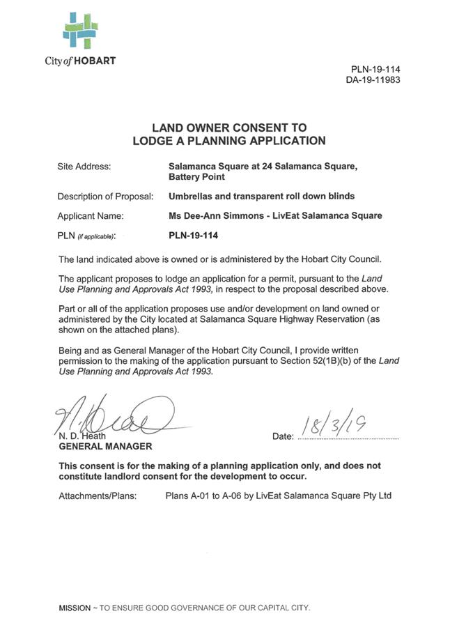
7.1 Applications under the Sullivans Cove Planning Scheme 1997
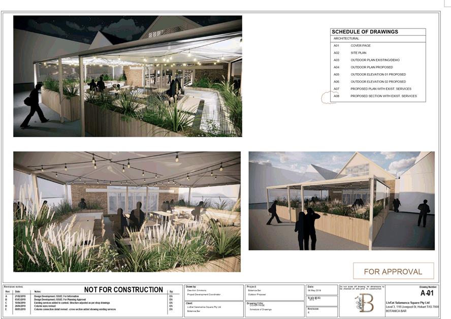
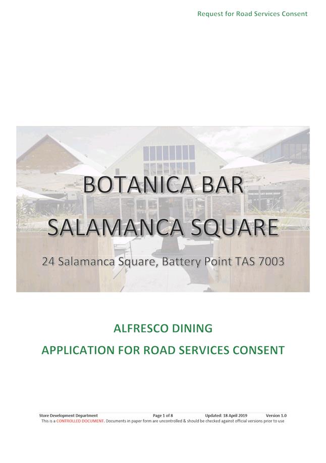
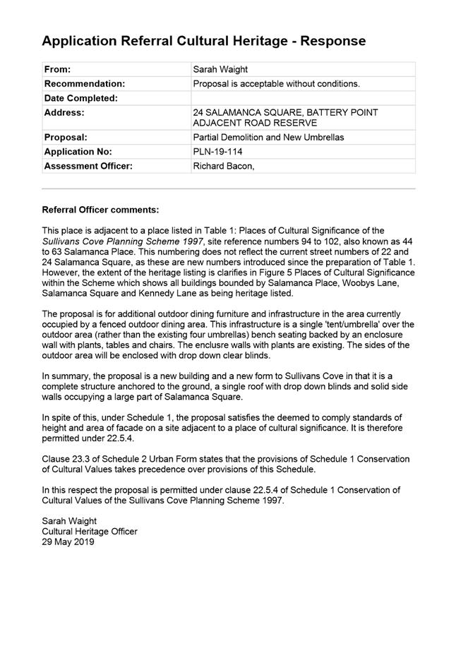
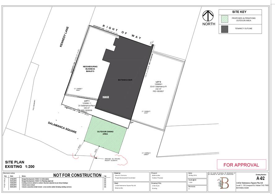
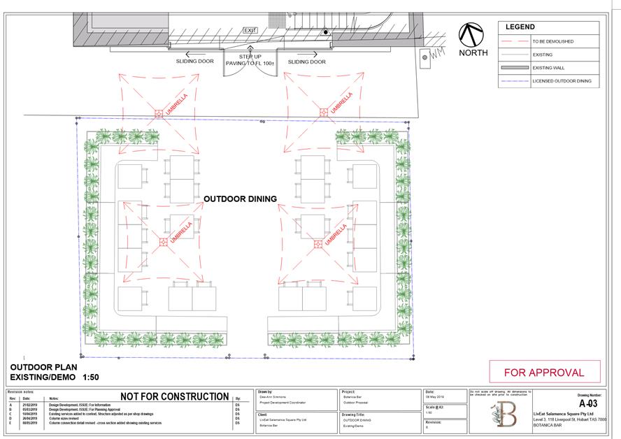
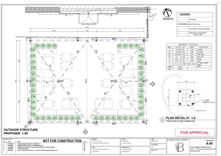
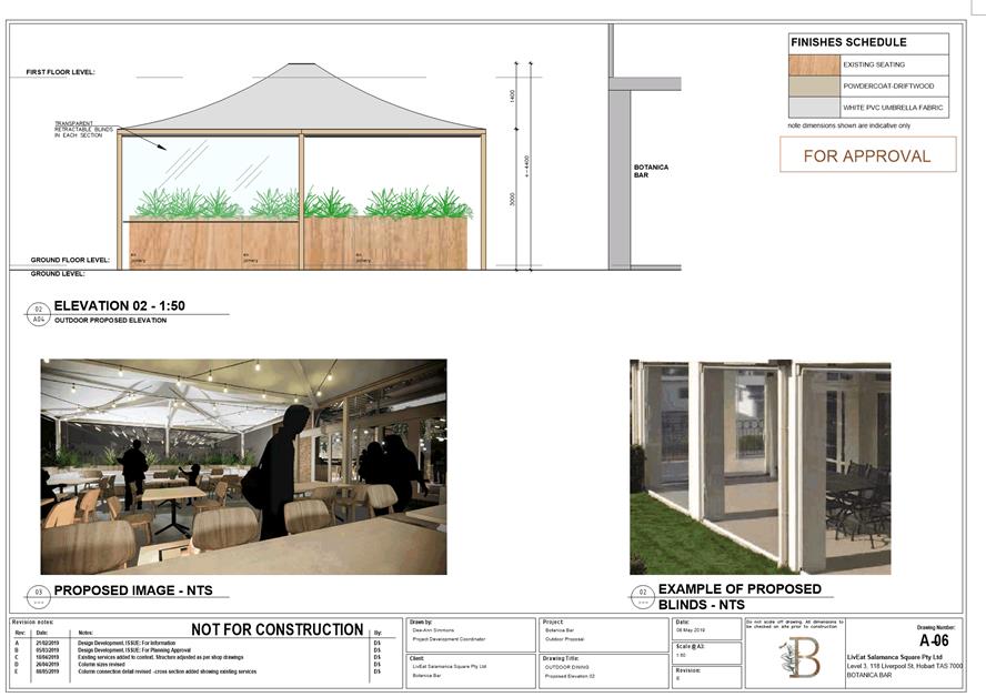
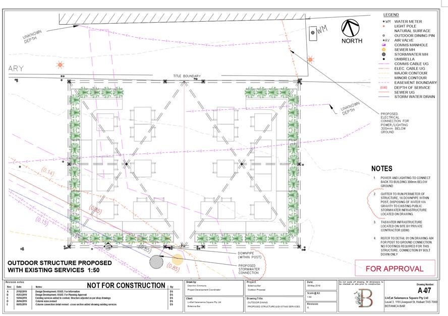
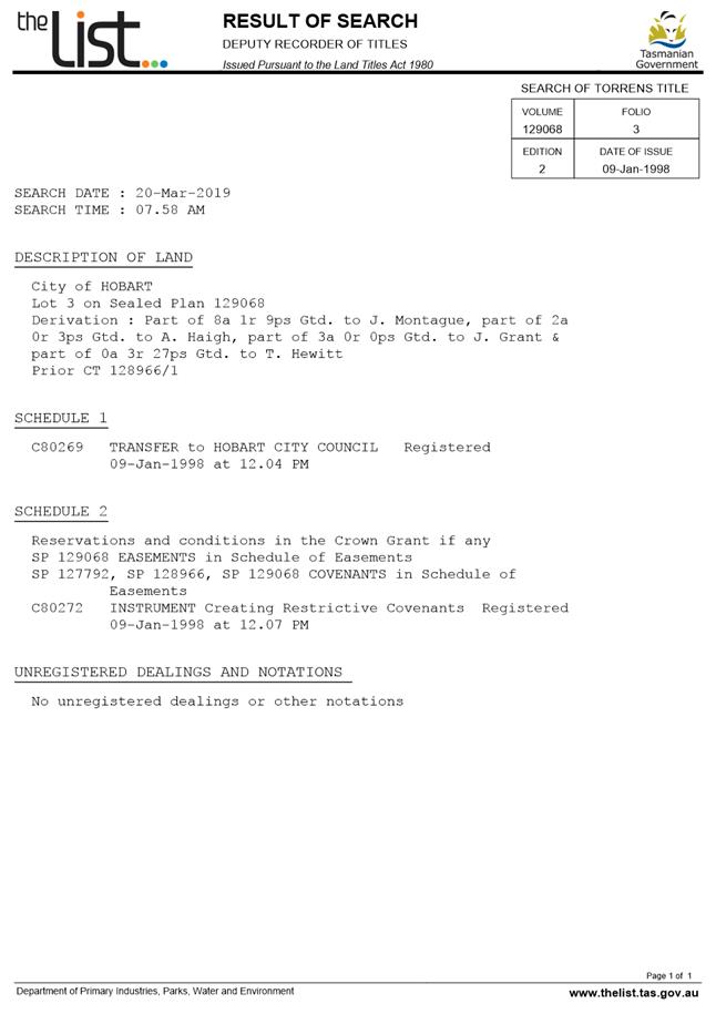
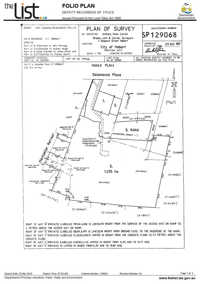
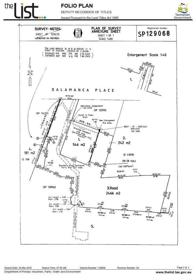
7.1.1 24 Salamanca Square, Battery Point and Adjacent Road Reserve - Partial Demolition and New Umbrellas
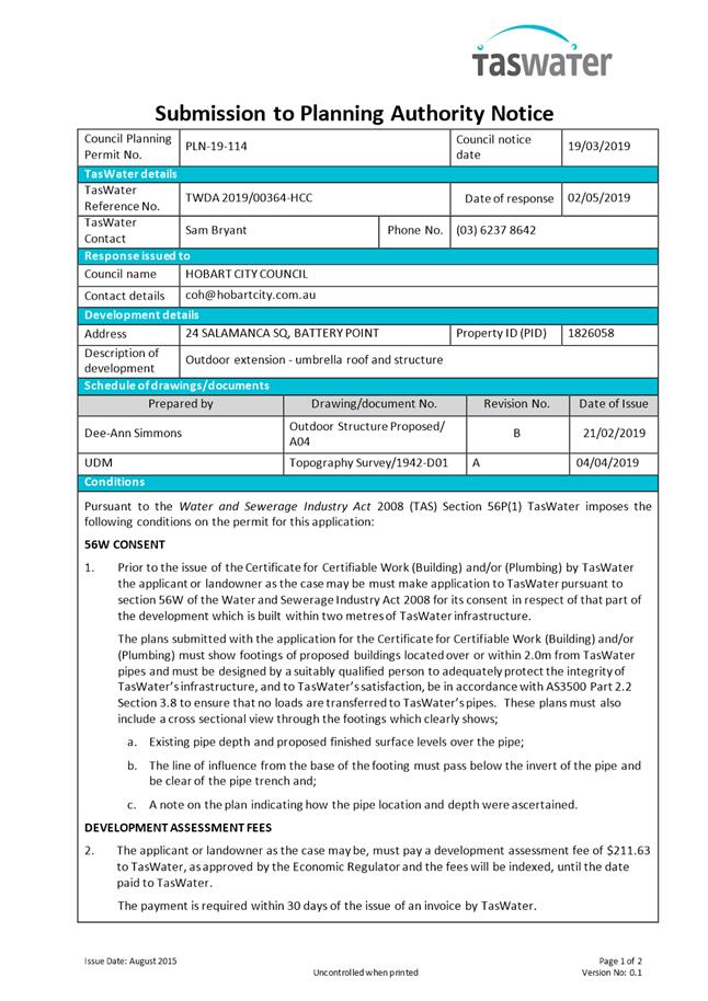
Address: 24 Salamanca Square, Battery Point and Adjacent Road Reserve
Proposal: Partial Demolition and New Umbrellas
Expiry Date: 25 July 2019
Extension of Time: Not applicable
Author: Richard Bacon
|
REcommendation That pursuant to the Sullivans Cove Planning Scheme 1997, the Council approve the application for a partial demolition and extension (new umbrella roof and structure) at 24 Salamanca Square, Battery Point TAS 7004 for the reasons outlined in the officer’s report and a permit containing the following conditions be issued:
GEN
The use and/or development must be substantially in accordance with the documents and drawings that comprise PLN19114 24 SALAMANCA SQUARE BATTERY POINT AND ADJACENT ROAD RESERVE BATTERY POINT TAS 7000 CPC Agenda Documents except where modified below.
Reason for condition
To clarify the scope of the permit.
TW
The use and/or development must comply with the requirements of TasWater as detailed in the form Submission to Planning Authority Notice, Reference No. TWDA 2019/00364HCC dated 2 May 2019 as attached to the permit.
Reason for condition
To clarify the scope of the permit.
ENG sw4
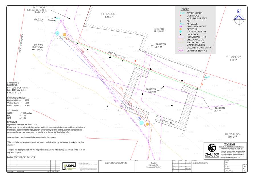
The proposed covered area must be drained to Council infrastructure. Any new stormwater connection required must be constructed by the Council at the owner’s expense prior to use.
Detailed design drawings showing both existing and proposed services must be submitted and approved. The detailed design drawings must:
1. Include the proposed levels of the connection; 2. Include longsections of the proposed connection, clearly showing any nearby services, cover, size, material and delineation of public and private infrastructure; 3. Provide sufficient details of reinstatement required; 4. Show a pedestrian suitable cover lid for the connection point when not in use; and 5. Be checked and certified by a qualified and experienced person(s).
All work required by this condition must be undertaken in accordance with the approved detailed design drawings.
Advice:
Prior to commencing any works the applicant must obtain an 'application for a new stormwater connection', from Council's City Amenity Division.
Reason for condition
To ensure
that stormwater from the site will be discharged to a suitable Council approved outlet, and not pose a risk to pedestrians. In accordance with the hazard and risk mitigation of the Planning Scheme Environmental Objectives.
ENG 1
Any damage to council infrastructure resulting from the implementation of this permit, must, at the discretion of the Council:
1. Be met by the owner by way of reimbursement (cost of repair and reinstatement to be paid by the owner to the Council); or 2. Be repaired and reinstated by the owner to the satisfaction of the Council.
A photographic record of the Council's infrastructure adjacent to the subject site must be provided to the Council prior to any commencement of works.
A photographic record of the Council’s infrastructure (e.g. existing property service connection points, roads, buildings, stormwater, footpaths, driveway crossovers and nature strips, including if any, preexisting damage) will be relied upon to establish the extent of damage caused to the Council’s infrastructure during construction. In the event that the owner/developer fails to provide to the Council a photographic record of the Council’s infrastructure, then any damage to the Council's infrastructure found on completion of works will be deemed to be the responsibility of the owner.
Reason for condition
To ensure that any of the Council's infrastructure and/or siterelated service connections affected by the proposal will be altered and/or reinstated at the owner’s full cost.
ENG r1
The proposal must ensure it does not compromise the area's primary function as a public space that may on occasion be utilised for public events or as a public roadway for access. To achieve this, the proposal must demonstrate that:
1. Emergency vehicle access to Salamanca Square is not compromised; 2. The structure can be safely and readily decommissioned, as well as removed from site, within a reasonable time frame; 3. Damage and intrusion into the road pavement is minimized; 4. Mitigation measures to ensure no pedestrian trip hazards will be present after removal; and 5. There is no obstruction of access to utility service access point.
Advice:
· Prior to undertaking construction, the applicant must obtain a Traffic Management and Road Opening permit from Council’s City Amenity Division. · Prior to commencement of use of the proposal, the applicant must obtain a new Occupancy Agreement from Council’s City Planning Division.
Reason for condition
To ensure access and amenity of the roadway is not permanently compromise.
ENV 1
Sediment and erosion control measures sufficient to prevent sediment from leaving the site must be installed prior to any disturbance of the site, and maintained until all areas of disturbance have been stabilized.
Advice:
For further guidance in preparing a Soil and Water Management Plan – in accordance with Fact sheet 3 Derwent Estuary Program click here.
Reason for condition
To avoid the sedimentation of roads, drains, natural watercourses, Council land that could be caused by erosion and runoff from the development, and to comply with relevant State legislation.
ADVICE
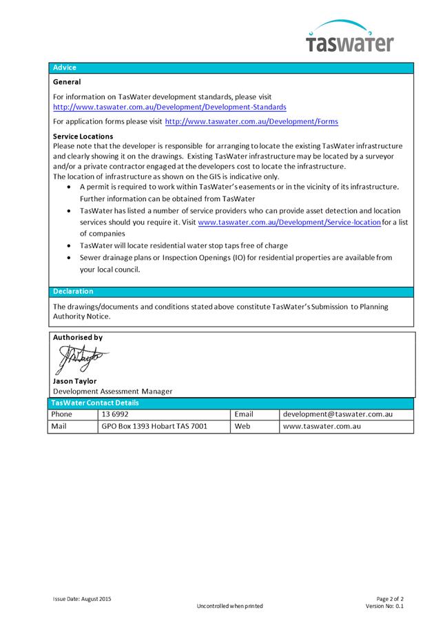
The following advice is provided to you to assist in the implementation of the planning permit that has been issued subject to the conditions above. The advice is not exhaustive and you must inform yourself of any other legislation, bylaws, regulations, codes or standards that will apply to your development under which you may need to obtain an approval. Visit the Council's website for further information.
Prior to any commencement of work on the site or commencement of use the following additional permits/approval may be required from the Hobart City Council.
BUILDING PERMIT
You may need building approval in accordance with the Building Act 2016. Click here for more information.
This is a Discretionary Planning Permit issued in accordance with section 57 of the Land Use Planning and Approvals Act 1993.
PLUMBING PERMIT
You may need plumbing approval in accordance with the Building Act 2016, Building Regulations 2016 and the National Construction Code. Click here for more information.
OCCUPATION OF THE PUBLIC HIGHWAY
You may require a permit for the occupation of the public highway for construction (e.g. placement of skip bin, crane, scissor lift etc). Click here for more information.
You may require an occupational licence for use of Hobart City Council highway reservation (e.g. outdoor seating, etc). Click here for more information.
You may require an occupational license for structures in the Hobart City Council highway reservation, in accordance with conditions to be established by the Council. Click here for more information.
You may require a road closure permit for construction. Click here for more information.
You may require a Permit to Open Up and Temporarily Occupy a Highway (for work in the road reserve). Click here for more information.
STORMWATER
Please note that in addition to a building and/or plumbing permit, development must be in accordance with the Hobart City Council’s Hydraulic Services By law. Click here for more information.
STRUCTURES CLOSE TO COUNCILS' STORMWATER MAIN
The design of structures (including footings) must provide protection for the Council’s infrastructure. For information regarding appropriate designs please contact the Council's City Amenity Division.
WORK WITHIN THE HIGHWAY RESERVATION
Please note development must be in accordance with the Hobart City Council’s Highways By law. Click here for more information.
FEES AND CHARGES
Click here for information on the Council's fees and charges.
DIAL BEFORE YOU DIG
Click here for dial before you dig information.
|
Attachment a: PLN-19-114
- 24 SALAMANCA SQUARE BATTERY POINT TAS 7004 - Planning Committee or Delegated
Report ⇩ ![]()
Attachment
b: PLN-19-114
- 24 SALAMANCA SQUARE BATTERY POINT TAS 7004 - CPC Agenda Documents ⇩ ![]()
Attachment
c: PLN-19-114
- 24 SALAMANCA SQUARE BATTERY POINT TAS 7004 - Planning Referral Officer
Cultural Heritage Report ⇩ ![]()
|
Item No. 7.1.1 |
Agenda (Open Portion) City Planning Committee Meeting - 24/6/2019 |
Page 15 ATTACHMENT a |

|
Agenda (Open Portion) City Planning Committee Meeting - 24/6/2019 |
Page 37 ATTACHMENT b |

|
Item No. 7.1.1 |
Agenda (Open Portion) City Planning Committee Meeting - 24/6/2019 |
Page 46 ATTACHMENT b |
|
Item No. 7.1.1 |
Agenda (Open Portion) City Planning Committee Meeting - 24/6/2019 |
Page 48 ATTACHMENT b |
|
Item No. 7.1.1 |
Agenda (Open Portion) City Planning Committee Meeting - 24/6/2019 |
Page 50 ATTACHMENT b |


|
Item No. 7.1.1 |
Agenda (Open Portion) City Planning Committee Meeting - 24/6/2019 |
Page 71 ATTACHMENT c |
|
Agenda (Open Portion) City Planning Committee Meeting |
Page 73 |
|
|
|
24/6/2019 |
|
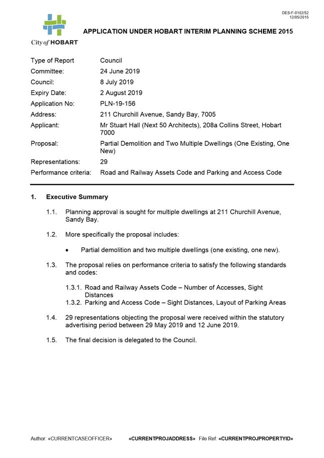
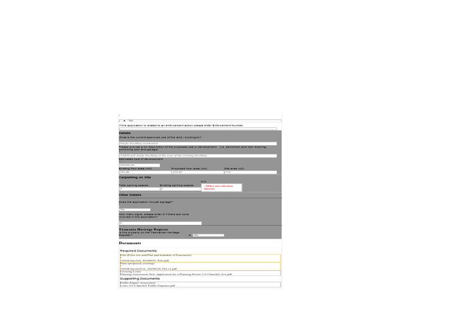
7.2 Applications under the Hobart Interim Planning Scheme 2015
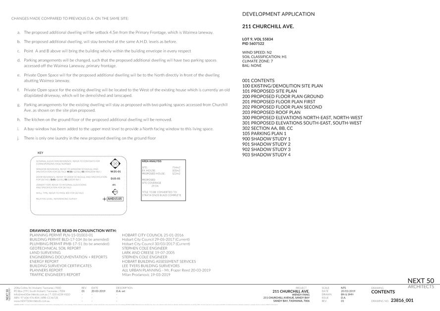
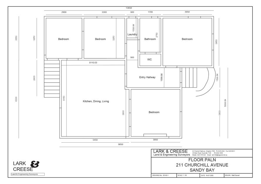
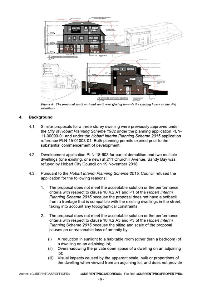
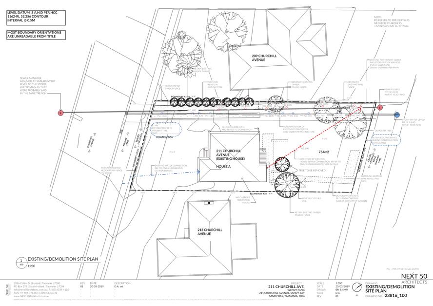
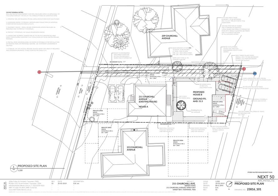
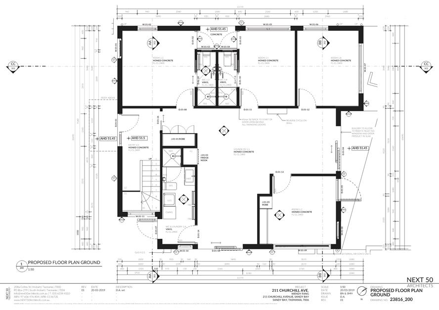
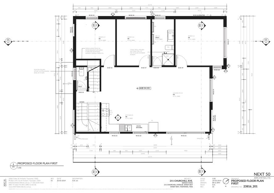
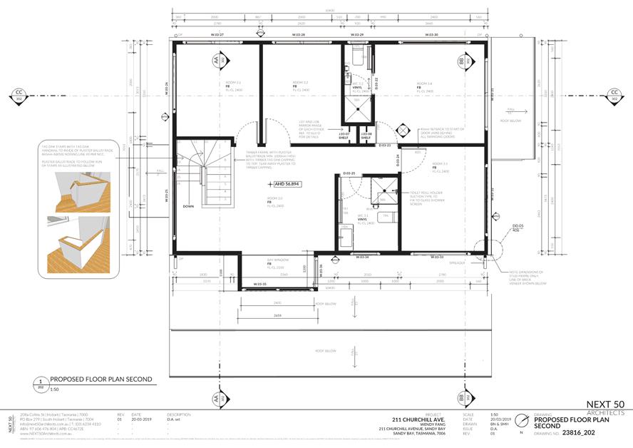
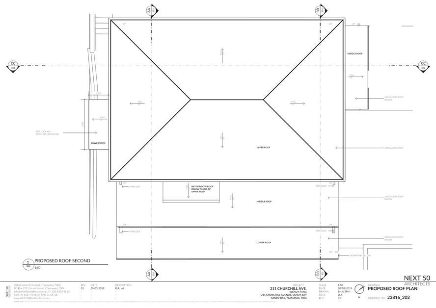
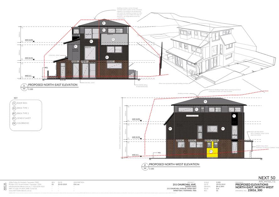
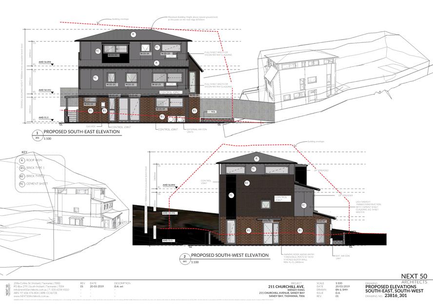
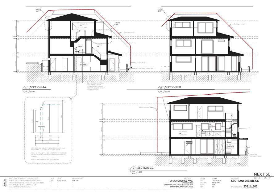
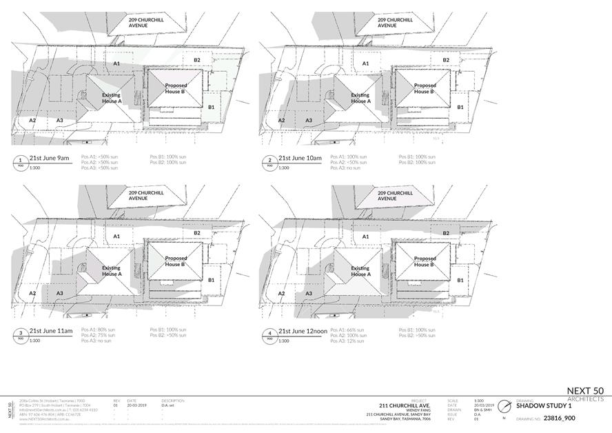
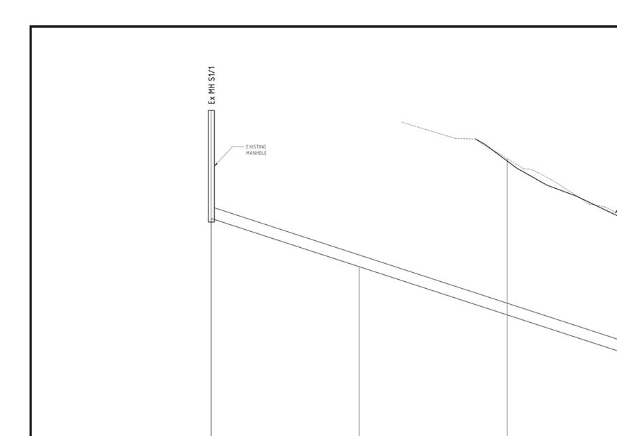
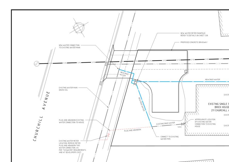
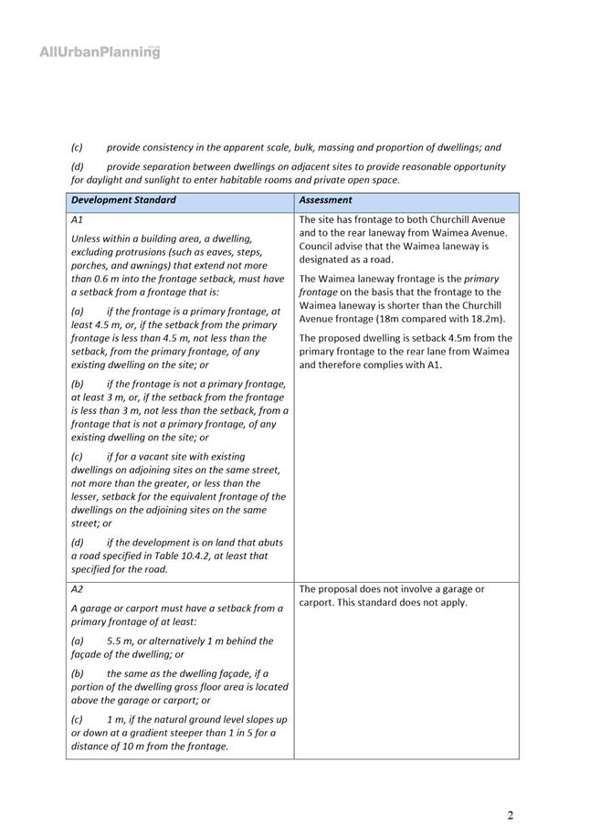
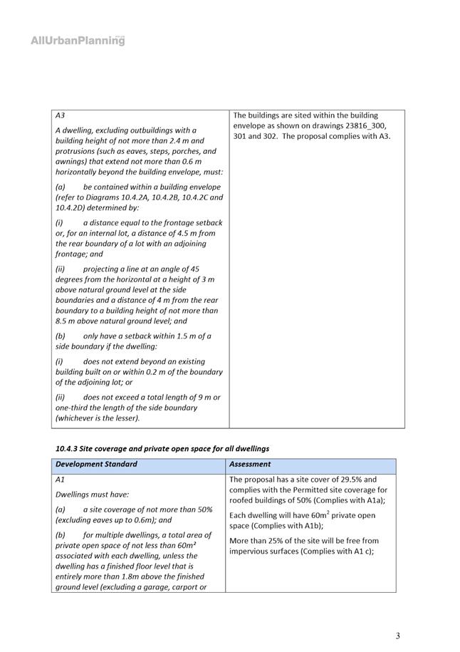
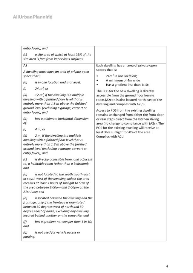
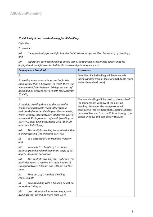
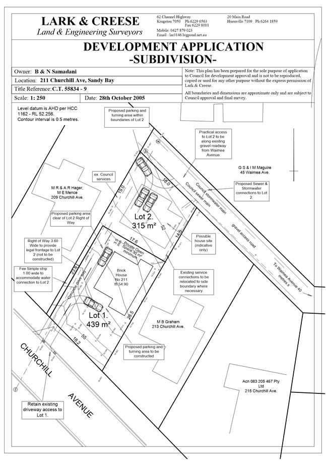
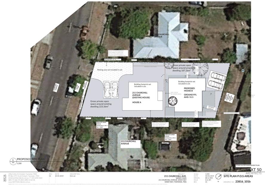
7.2.1 211 Churchill Avenue, Sandy Bay - Partial Demolition and Two Multiple Dwellings (One Existing, One New)
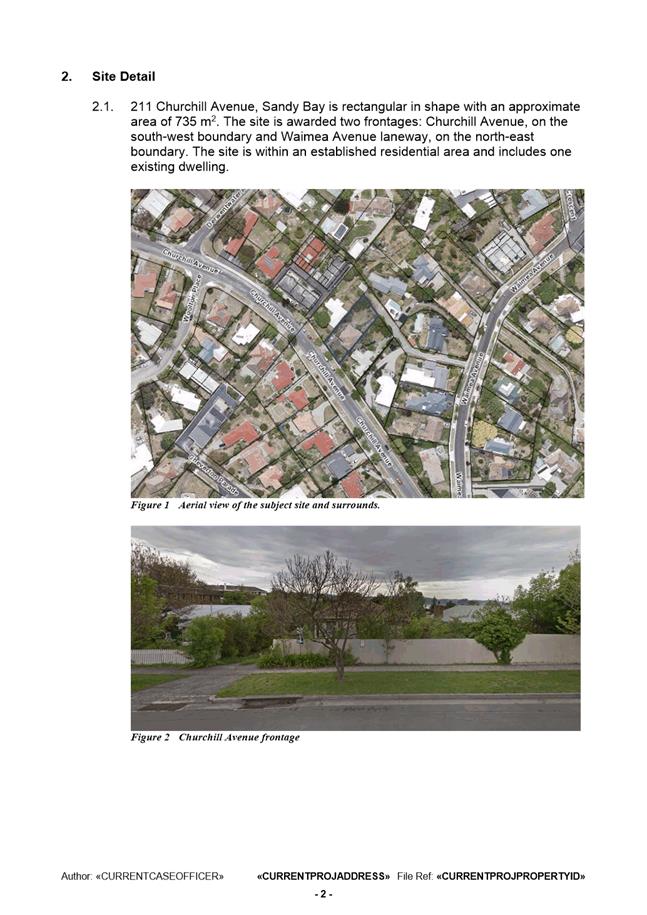
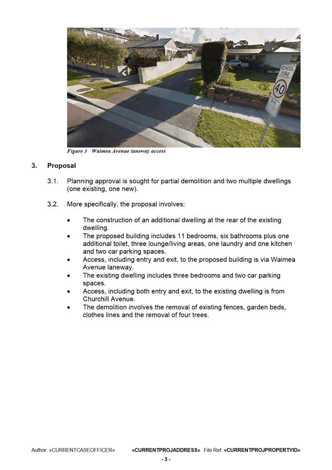
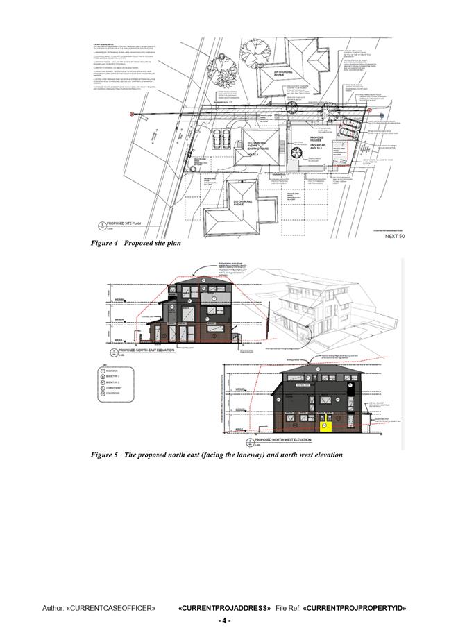
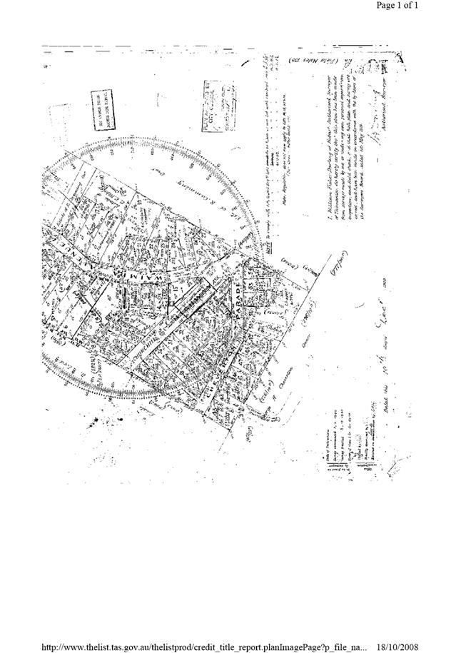
Address: 211 Churchill Avenue, Sandy Bay
Proposal: Partial Demolition and Two Multiple Dwellings (One Existing, One New)
Expiry Date: 2 August 2019
Extension of Time: Not applicable
Author: Ben Ikin
|
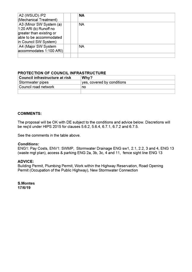
REcommendation That pursuant to the Hobart Interim Planning Scheme 2015, the Council approve the application for partial demolition and two multiple dwellings (one existing, one new) at 211 Churchill Avenue, Sandy Bay, 7005 for the reasons outlined in the officer’s report and a permit containing the following conditions be issued:
GEN
The use and/or development must be substantially in accordance with the documents and drawings that comprise PLN-19-156 - 211 CHURCHILL AVENUE SANDY BAY TAS 7005 – Final Planning Documents, except where modified below.
Reason for condition
To clarify the scope of the permit.
TASWATER
The use and/or development must comply with the
requirements of TasWater as detailed in the form Submission to Planning
Authority Notice, Reference No. TWDA 2019/00403-HCC dated 28/03/2019 as
attached to the permit.
ENV 1
Sediment and erosion control measures sufficient to prevent sediment from leaving the site must be installed prior to any disturbance of the site. Sediment controls must be maintained until all areas of disturbance have been stabilized or revegetated.
Advice: For further guidance in preparing Soil and Water Management Plans in accordance with Fact Sheet 3 Derwent Estuary Program go to www.hobartcity.com.au development engineering standards and guidelines.
Reason for condition
To avoid the sedimentation of roads, drains, natural watercourses, Council land that could be caused by erosion and runoff from the development, and to comply with relevant State Legislation.
ENG 1
The cost of repair of any damage to the Council’s infrastructure resulting from the implementation of this permit, must be met by the owners within 30 days of the completion of the development.
A photographic record of the Council’s infrastructure adjacent to the subject site must be provided to the Council prior to any commencement of works.
A photographic record of the Council’s infrastructure (e.g. existing property service connection points, roads, buildings, stormwater, footpaths, driveway crossovers and nature strip, including if any, pre existing damage) will be relied upon to establish the extent of damage caused to the Council’s infrastructure during construction. In the event that the owner/developer fails to provide to the Council a photographic record of the Council’s infrastructure, then any damage to the Council’s infrastructure found on completion of works will be deemed to be the responsibility of the owner.
Reason for condition
To ensure that any of the Council’s infrastructure and/or site-related service connections affected by the proposal will be altered and/or reinstated at the owner’s full cost.
ENG sw1
All stormwater runoff from the proposed development (including but not limited to: roofed areas, ag drains and impervious surfaces such as driveways and paved areas) must be drained to the Council’s stormwater infrastructure prior to first occupation or commencement of use (whichever occurs first).
Reason for condition
To ensure that stormwater from the site will be discharged to a suitable Council approved outlet.
ENG sw2.1
A pre-construction CCTV video of the 300mm diameter Council stormwater main that is located within the property must be undertaken and submitted to Council prior to the commencement of work.
The post construction CCTV will be relied upon to establish the extent of any damage caused to the Council’s infrastructure during construction. In the event that the owner/developer fails to provide to the Council a pre-construction CCTV video of the Council’s infrastructure, then any damage to the Council infrastructure identified in the post construction CCTV video will be deemed to be the responsibility of the owner.
Reason for condition
To ensure that any of the Council infrastructure and/or site-related service connections affected by the proposal will be altered and/or reinstated at the owner’s full cost.
ENG sw2.2
A post construction CCTV video of the Council stormwater main within the subject site must be undertaken and submitted to the Council on completion of all work.
The post construction CCTV video will be relied upon to establish the extent of any damage caused to the Council’s infrastructure during construction. In the event that the owner/developer fails to provide to the Council a pre-construction CCTV video of the Council’s infrastructure, then any damage to the Council infrastructure identified in the post construction CCTV video will be deemed to be the responsibility of the owner.
Reason for condition
To ensure that any of the Council infrastructure and/or site-related service connections affected by the proposal will be altered and/or reinstated at the owner’s full cost.
ENG sw3
The proposed new dwelling (including foundations and overhangs), driveways and parking areas must be designed to ensure the protection and access to the Council’s existing stormwater main.
A detailed design must be submitted and approved prior to the issuing of any consent under the Building Act 2016. The design must demonstrate how protection, adequate clearances and access to the stormwater main will be achieved.
All work required by this condition must be undertaken in accordance with the approved design drawings.
Reason for condition
To ensure the protection of the Council’s hydraulic infrastructure.
ENG sw4
The new stormwater connection must be constructed and any existing connections to be abandoned must be sealed by the Council at the owner’s expense, prior to the first occupation.
Detailed engineering drawings must be submitted and approved, prior to commencement of work. The detailed engineering drawings must include:
1. The location of the proposed connection; and 2. The size of the connection appropriate to satisfy the needs of the development.
All work required by this condition must be undertaken in accordance with the approved detailed engineering drawings.
Advice: · The applicant is advised to submit detailed design drawings via a Council City Infrastructure Division application for a new stormwater connection. If detailed design to satisfy this condition is submitted via the planning condition endorsement process there may be fees associated with the assessment, and once approved the applicant will still need to submit an application for a new stormwater connection with Council City Amenity Division. · Where building / plumbing approval is also required, it is recommended that documentation to satisfy this condition is submitted well before submitting documentation for building/plumbing approval. Failure to address planning condition requirements prior to submitting for building/plumbing approval may result in unexpected delays.
Reason for condition
To ensure the site is drained adequately.
ENG 13
An ongoing waste management plan for all domestic waste and recycling must be implemented post construction.
A waste management plan must be submitted and approved, prior to commencement of work on the site. A waste management plan must include provisions for the handling, storage, transport and disposal of domestic waste and recycle bins from the development, either by Council or commercial waste services.
All work required by this condition must be undertaken in accordance with the approved waste management plan.
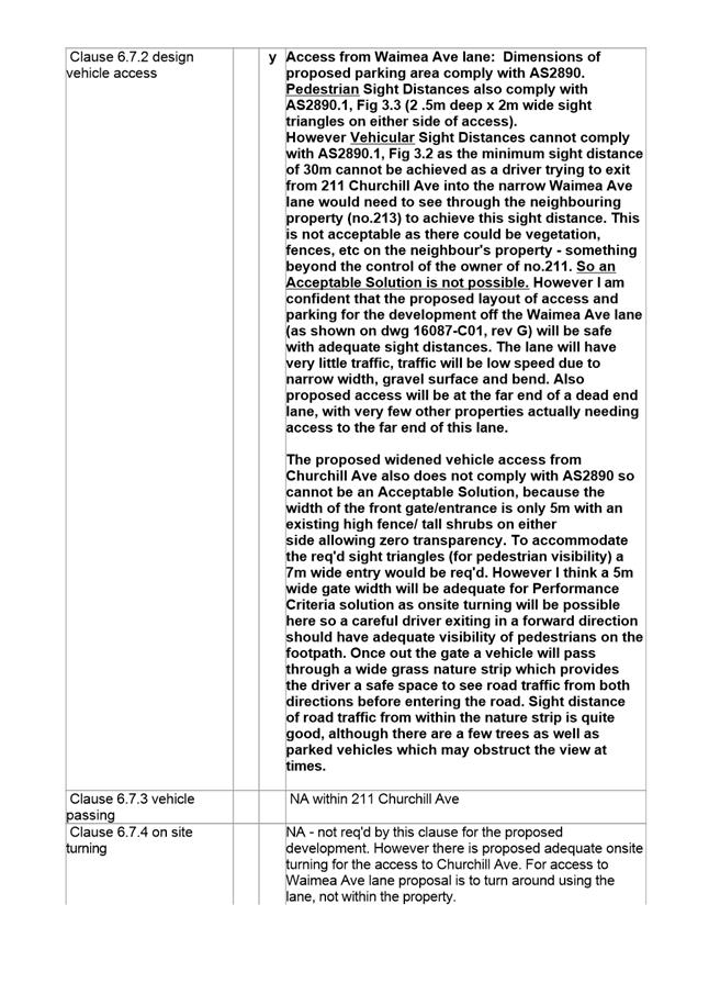
Advice: · Note that for Council to collect waste and recycling, wheelie bins must be placed either in Churchill Ave roadside or Waimea Ave roadside (about 70m from the rear of this property). Council will not collect rubbish from the narrow gravel lane. · Once the waste management plan has been approved Council will issue a condition endorsement (see general advice on how to obtain condition endorsement). · Where building approval is also required, it is recommended that documentation for condition endorsement be submitted well before submitting documentation for building approval. Failure to address condition endorsement requirements prior to submitting for building approval may result in unexpected delays.
Reason for condition
To ensure that solid waste management from the site meets the Council’s requirements and standards.
ENG 2a
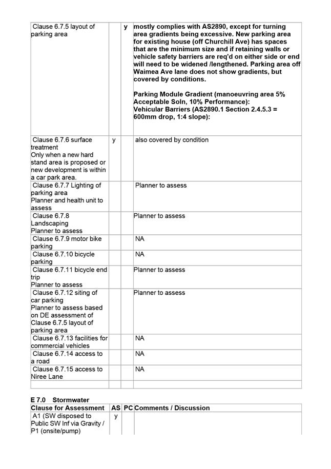
Prior to first occupation or commencement of use (whichever occurs first), vehicular barriers compliant with the Australian Standard AS/NZS1170.1:2002 must be installed to prevent vehicles running off the edge of an access driveway or parking module (parking spaces, aisles and manoeuvring area) where the drop from the edge of the trafficable area to a lower level is 600mm or greater, and wheel stops (kerb) must be installed for drops between 150mm and 600mm. Barriers must not limit the width of the driveway access or parking and turning areas approved under the permit.
Advice: · The Council does not consider a slope greater than 1 in 4 to constitute a lower level as described in AS/NZS 2890.1:2004 Section 2.4.5.3. Slopes steeper than 1 in 4 will require a vehicular barrier or wheel stop. · Designers are advised to consult the National Construction Code 2016 to determine if pedestrian handrails or safety barriers compliant with the NCC2016 are also required in the parking module this area may be considered as a path of access to a building.
Reason for condition
To ensure the safety of users of the access driveway and parking module and compliance with the standard.
ENG 3b
The design of the access driveway, parking and turning areas must be submitted and approved, prior to the issuing of any approval under the Building Act 2016.
The design must:
1. Be prepared and certified by a suitably qualified engineer, 2. Be generally in accordance with the Australian Standard AS/NZS2890.1:2004, 3. Where the design deviates from AS/NZS2890.1:2004 the designer must demonstrate that the design will provide a safe and efficient access, and enable safe, easy and efficient use, and 4. Show dimensions, levels, gradients and other details as Council deem necessary to satisfy the above requirement.
Reason for condition
To ensure the safety of users of the access and parking areas, and compliance with the relevant Australian Standard.
ENG 3c
The access driveway, parking and turning areas must be constructed in accordance with the design drawings approved by Condition ENG 3b.
Prior to the commencement of use, documentation by a suitably qualified engineer certifying that the access driveway and parking areas have been constructed in accordance with the above drawings must be lodged with Council.
Reason for condition
To ensure the safety of users of the access and parking module, and compliance with the relevant Australian Standard.
ENG 4
The access driveway, parking and turning areas approved by this permit must be constructed to a sealed standard (spray seal, asphalt, concrete, pavers or equivalent Council approved) and surface drained to the Council's stormwater infrastructure prior to the commencement of use.
Reason for condition
To ensure the safety of users of the access driveway and parking areas, and so that it does not detract from the amenity of users, adjoining occupiers or the environment by preventing dust, mud and sediment transport.
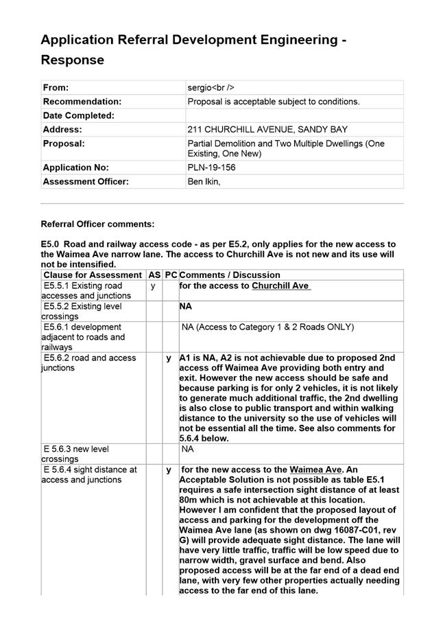
ENG 11
Prior to the commencement of the use, the proposed crossovers to the Churchill Avenue and Waimea Avenue highway reservations must be designed and constructed in general accordance with:
1. LGAT Standard Drawing - Urban - TSD-R09-v1 – Urban Roads Driveways and TSD R14-v1 Type KC vehicular crossing; 2. LGAT Standard Drawing - Footpath - Urban Roads Footpaths TSD-R11-v1; or 3. A Council City Infrastructure Division approved alternate design.
Advice: · Local Government Association (LGAT) Tasmanian Standard Drawings (TSD) can be viewed electronically via the LGAT Website. · It is advised that designers consider the detailed design of the crossover, access and parking module prior to finalising the Finished Floor Level (FFL) of the parking spaces (especially if located within a garage incorporated into the dwelling), as failure to do so may result in difficulty complying with this condition. · Please note that your proposal does not include adjustment of footpath levels. Any adjustment to footpath levels necessary to suit the design of proposed floor, parking module or driveway levels will require separate agreement from Council's Road Services Engineer and may require further planning approvals. It is advised to place a note to this affect on construction drawings for the site and/or other relevant engineering drawings to ensure that contractors are made aware of this requirement. · Please contact Council City Infrastructure Division to discuss approval of alternate designs. Based on a site specific assessment, Council City Infrastructure Division Road Engineer may permit extending non-approved concrete slab crossover, and where non-standard kerb and channel exists a concrete plinth to Council standards may be permitted for construction at the gutter. · You are likely to require a Permit to Open Up and Temporarily Occupy a Highway (for work within the highway reservation). Click here for more information.
Reason for condition
In the interests of vehicle user safety and the amenity of the development.
ENG 13
The front fencing and gate at the frontage to Churchill Ave and Waimea Ave must allow for adequate visibility and sight distance between user vehicles, cyclists and pedestrians.
Amended drawings must be submitted and approved, prior to the commencement of work. The drawings must demonstrate how the fence on either side of the driveways provides for adequate sight distance between user vehicles, cyclists and pedestrians by one of the following methods:
1. Compliance with Australian/NZ Standard, Parking facilities Part 1: Off-street car parking AS/NZS 2890.1: 2004 Fig 3.3; 2. Increasing the clear opening gate width of the driveway to at least 5m; or 3. Another Council approved method.
All work required by this condition must be undertaken in accordance with the approved drawings.
Advice: · The applicant may submit amended drawings to satisfy this condition as either part of a Building Application, or alternatively via Council's planning condition endorsement process (noting there is a fee associated with condition endorsement approval of engineering drawings [see general advice on how to obtain condition endorsement and for fees and charges]). · Failure to address condition requirements prior to submitting for building approval may result in unexpected delays.
Reason for condition
To ensure the safety of vehicles entering and leaving the development and of pedestrians and traffic in the vicinity.
ADVICE
The following advice is provided to you to assist in the
implementation of the planning permit that has been issued subject to the
conditions above. The advice is not exhaustive and you must inform yourself
of any other legislation, by-laws, regulations, codes or standards that will
apply to your development under which you may need to obtain an approval.
Visit the Council's website for
further information.
BUILDING PERMIT
You may need building approval in accordance with
the Building Act 2016. Click here for
more information.
PLUMBING PERMIT
You may need plumbing approval in accordance with the Building Act 2016, Building Regulations 2016 and the National Construction Code. Click here for more information.
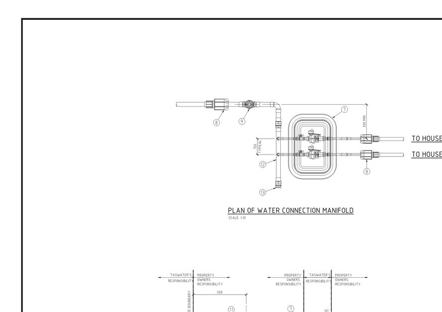
NEW SERVICE CONNECTION
NOISE REGULATIONS
Click here for information with respect to noise nuisances in residential areas.
FEES AND CHARGES
Click here for information on the Council's fees and charges.
DIAL BEFORE YOU DIG
Click here for dial before you dig information.
|
Attachment a: PLN-19-156
- 211 CHURCHILL AVENUE SANDY BAY TAS 7005 - Planners Assessment Report FINAL -
Planning Committee Delegated Report externally prepared
⇩ ![]()
Attachment
b: PLN-19-156
- 211 CHURCHILL AVENUE SANDY BAY TAS 7005 – CPC Agenda Documents ⇩ ![]()
Attachment
c: PLN-19-156
- 211 CHURCHILL AVENUE SANDY BAY TAS 7005 - Planning Referral Officer
Development Engineering Report ⇩ ![]()
|
Item No. 7.2.1 |
Agenda (Open Portion) City Planning Committee Meeting - 24/6/2019 |
Page 82 ATTACHMENT a |
|
Agenda (Open Portion) City Planning Committee Meeting - 24/6/2019 |
Page 103 ATTACHMENT b |
|
Item No. 7.2.1 |
Agenda (Open Portion) City Planning Committee Meeting - 24/6/2019 |
Page 105 ATTACHMENT b |
|
Item No. 7.2.1 |
Agenda (Open Portion) City Planning Committee Meeting - 24/6/2019 |
Page 129 ATTACHMENT b |
|
Item No. 7.2.1 |
Agenda (Open Portion) City Planning Committee Meeting - 24/6/2019 |
Page 141 ATTACHMENT b |
|
Item No. 7.2.1 |
Agenda (Open Portion) City Planning Committee Meeting - 24/6/2019 |
Page 144 ATTACHMENT b |

|
Item No. 7.2.1 |
Agenda (Open Portion) City Planning Committee Meeting - 24/6/2019 |
Page 159 ATTACHMENT b |
|
Item No. 7.2.1 |
Agenda (Open Portion) City Planning Committee Meeting - 24/6/2019 |
Page 162 ATTACHMENT c |

|
Agenda (Open Portion) City Planning Committee Meeting |
Page 167 |
|
|
|
24/6/2019 |
|
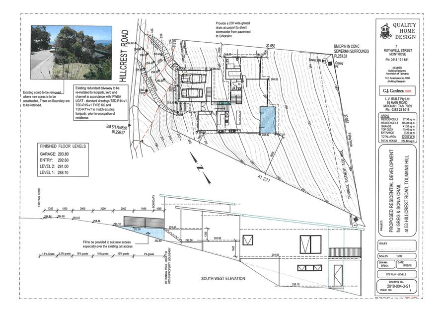
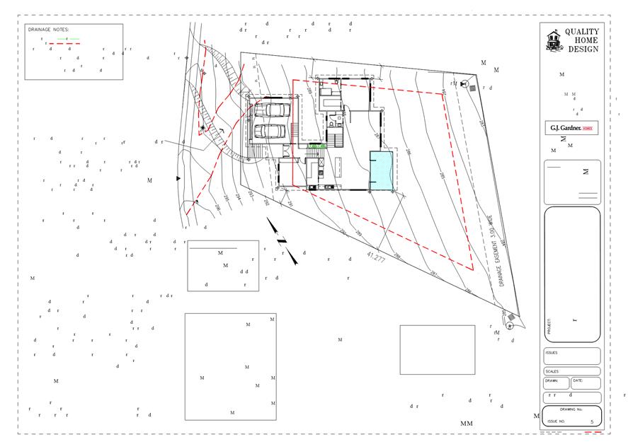
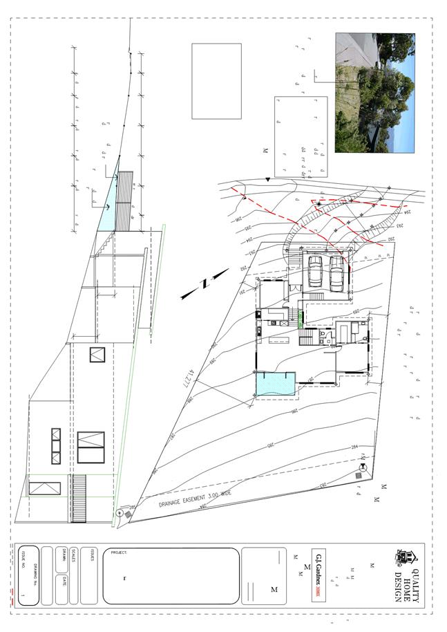
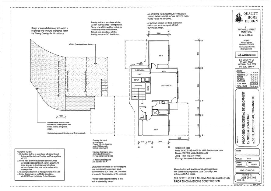
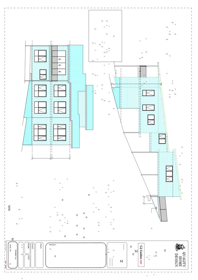
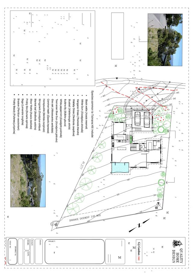
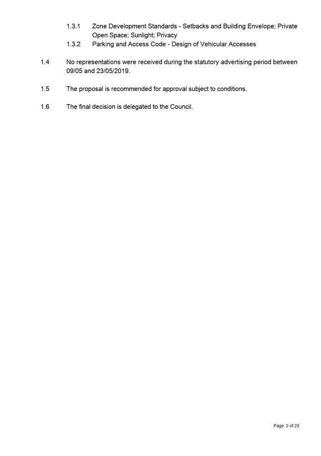
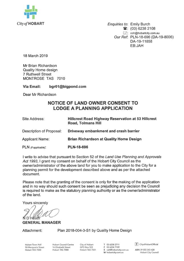
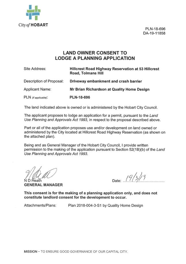
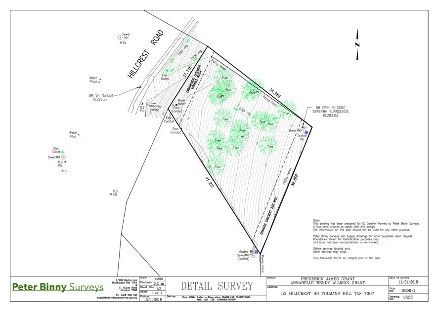
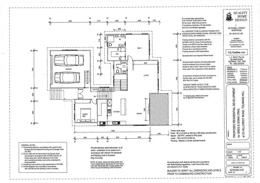
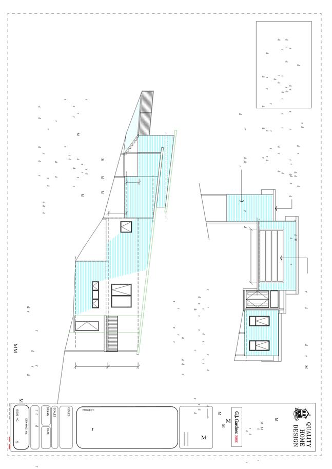
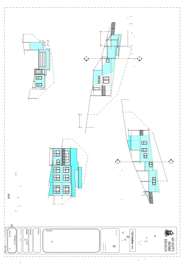
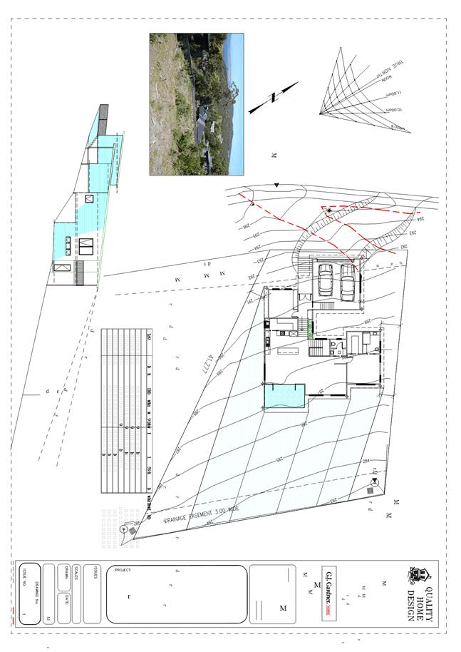
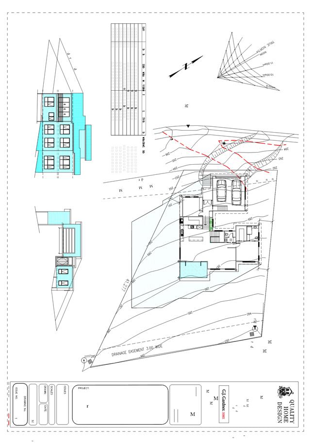
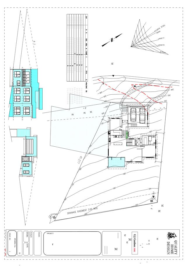
7.2.2 53 Hillcrest Road, Tolmans Hill and Adjacent Road Reserve - Dwelling
Address: 53 Hillcrest Road, Tolmans Hill and Adjacent Road Reserve
Proposal: Dwelling
Expiry Date: 17 July 2019
Extension of Time: Not applicable
Author: Cameron Sherriff
|
REcommendation That pursuant to the Hobart Interim Planning Scheme 2015, the Council approve the application for a dwelling at 53 Hillcrest Road, Tolmans Hill for the reasons outlined in the officer’s report and a permit containing the following conditions be issued:
GEN
The use and/or development must be substantially in accordance with the documents and drawings that comprise PLN18696 53 HILLCREST ROAD TOLMANS HILL TAS 7007 Final Planning Documents except where modified below.
Reason for condition
To clarify the scope of the permit.
THLAP 2
Landscaping of the site must be completed within 12 months of first occupation and maintained for the life of the building.
All work required by this condition must be undertaken in accordance with the approved Landscape Plan included in the Final Planning Documents.
Reason for condition
In the interest of protection of the landscape value of the area, and to minimise the spread of weeds.
THLAP 3
No additional trees or bushland growth outside the building envelope area (as shown in the Building Envelope Plan Figure 01 of Stage 17A of the Tolmans Hill Local Area Plan), or as otherwise approved by this permit, are to be removed or disturbed, unless further and separate planning approval is obtained.
The bushland area to be retained is to be temporarily fenced off, prior to any excavation work being undertaken on site and must remain in place until completion of building work.
Reason for condition
In order that the bushland nature of the Tolmans Hill Estate is retained.
PLN s1
The use of Colorbond Surfmist is not approved. An alternative, darker or mid toned colour must be used.
The use of natural (bare) concrete for the access drive and path to the front door is not approved. An alternative, darker or midtoned finish, or an incorporate exposed aggregate, must be used.
Details of appropriate alternative colours, materials and finishes must be submitted and approved prior to the issue of any approval under the Building Act 2016. The details must:
1. Identify the colour/finish/material name and manufacturer brand (if relevant); and 2. Include a sample image of the colour/finish/material.
All work required by this condition must be undertaken in accordance with the approved details.
Reason for condition
To ensure housing is integrated with the bushland character, and to ensure the new buildings are unobtrusive.
ENG sw1
All stormwater from the proposed development (including but not limited to: roofed areas, ag drains, retaining wall ag drains and impervious surfaces such as driveways and paved areas) must be drained to the Council’s stormwater infrastructure prior to first occupation or commencement of use (whichever occurs first).
Reason for condition
To ensure that stormwater from the site will be discharged to a suitable Council approved outlet.
ENG 2b
Prior to the issue of any approval under the Building Act 2016 or the commencement of works on site (whichever occurs first), a certified vehicle barrier design (including site plan with proposed location(s) of installation) prepared by a suitably qualified engineer, compliant with Australian Standard AS/NZS1170.1:2002, must be submitted to Council.
Advice:
· If the development's building approval includes the need for a Building Permit from Council, the applicant is advised to submit detailed design of vehicular barrier as part of the Building Application. · If the development's building approval is covered under Notifiable Work the applicant is advised to submit detailed design of vehicular barrier as a condition endorsement of the planning permit condition. Once the certification has been accepted, the Council will issue a condition endorsement (see general advice on how to obtain condition endorsement).
Reason for condition
To ensure the safety of users of the access driveway and parking module and compliance with the standard.
ENG 2c
Prior to the first occupation, vehicular barriers must be inspected by a qualified engineer and certification submitted to the Council confirming that the installed vehicular barriers comply with the certified design and Australian Standard AS/NZS1170.1:2002.
Advice:
· Certification may be submitted to the Council as part of the Building Act 2016 approval process or via condition endorsement (see general advice on how to obtain condition endorsement)
Reason for condition
To ensure the safety of users of the access driveway and parking module and compliance with the relevant standards.
ENG 3b
The access driveway and parking module (parking spaces, aisles and manoeuvring area) design must be submitted and approved, prior to the issuing of any approval under the Building Act 2016.
The access driveway, and parking module (parking spaces, aisles and manoeuvring area) design must:
1. Be prepared and certified by a suitably qualified engineer; 2. Be generally in accordance with the Australian Standard AS/NZS2890.1:2004; 3. Demonstrate that the design will provide a safe and efficient access, and enable safe, easy and efficient use, where the design deviates from AS/NZS2890.1:200; and 4. Show dimensions, levels, gradients and transitions, and other details as Council deem necessary to satisfy the above requirement.
Advice:
· It is advised that designers consider the detailed design of the access and parking module prior to finalising the Finished Floor Level (FFL) of the parking spaces (especially if located within a garage incorporated into the dwelling), as failure to do so may result in difficulty complying with this condition. · Once the design has been approved, the Council will issue a condition endorsement (see general advice on how to obtain condition endorsement). · Where building approval is also required, it is recommended that documentation for condition endorsement be submitted well before submitting documentation for building approval. Failure to address condition endorsement requirements prior to submitting for building approval may result in unexpected delays.
Reason for condition
To ensure the safety of users of the access and parking module, and compliance with the relevant Australian Standard.
ENG 3c
The access driveway, and parking module (parking spaces, aisles and manoeuvring area) must be constructed in accordance with the design drawings approved by Condition ENG 3b.
Prior to the first occupation, documentation by a suitably qualified engineer certifying that the access driveway and parking module has been constructed in accordance with the above drawings must be lodged with Council.
Advice:
· Certification may be submitted to Council as part of the Building Act 2016 approval process or via condition endorsement (see general advice on how to obtain condition endorsement)
Reason for condition
To ensure the safety of users of the access and parking module, and compliance with the relevant Australian Standard.
ENG 4
The access driveway and parking module (car parking spaces, aisles and manoeuvring area) approved by this permit must be constructed to a sealed standard (spray seal, asphalt, concrete, pavers or equivalent Council approved) and surface drained to the Council's stormwater infrastructure prior to the first occupation.
Reason for condition
To ensure the safety of users of the access driveway and parking module, and that it does not detract from the amenity of users, adjoining occupiers or the environment by preventing dust, mud and sediment transport.
ENG 1
Any damage to council infrastructure resulting from the implementation of this permit, must, at the discretion of the Council:
1. Be met by the owner by way of reimbursement (cost of repair and reinstatement to be paid by the owner to the Council); or 2. Be repaired and reinstated by the owner to the satisfaction of the Council.
A photographic record of the Council's infrastructure adjacent to the subject site must be provided to the Council prior to any commencement of works.
A photographic record of the Council’s infrastructure (e.g. existing property service connection points, roads, buildings, stormwater, footpaths, driveway crossovers and nature strips, including if any, preexisting damage) will be relied upon to establish the extent of damage caused to the Council’s infrastructure during construction. In the event that the owner/developer fails to provide to the Council a photographic record of the Council’s infrastructure, then any damage to the Council's infrastructure found on completion of works will be deemed to be the responsibility of the owner.
Reason for condition
To ensure that any of the Council's infrastructure and/or siterelated service connections affected by the proposal will be altered and/or reinstated at the owner’s full cost.
ENG r1
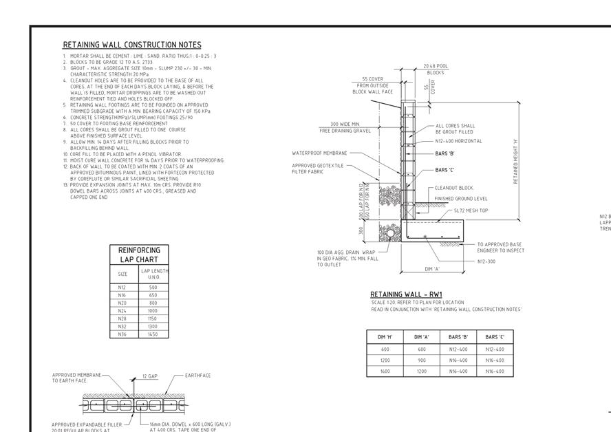
The excavation and/or earthretaining structures (i.e. embankments, cuttings, retaining walls) and footings and driveway within or supporting the highway reservation must not undermine the stability and integrity of the highway reservation and its infrastructure.
Detailed design drawings, structural certificates and associated geotechnical assessments of the embankments, footings, retaining walls and driveway supporting and/or within the Hillcrest Road highway reservation must be submitted and approved, prior to the commencement of work and must:
1. Be prepared and certified by a suitable qualified person and experienced engineer; 2. Not undermine the stability of the highway reservation; 3. Be designed in accordance with AS4678, with a design life in accordance with table 3.1 typical application major public infrastructure works; 4. Take into account any additional surcharge loadings as required by relevant Australian Standards; 5. Take into account and reference accordingly any Geotechnical findings; 6. Include pedestrian handrails on all retaining walls greater than 900mm located within the highway reservation; 7. Detail any mitigation measures required; and 8. Ensure that the structure certificated and/or drawings is notated in accordance with the above.
All work required by this condition must be undertaken in accordance with the approved select design drawing and structural certificates.
Advice:
· The applicant is required submit detailed design documentation to satisfy this condition via Council's planning condition endorsement process (noting there is a fee associated with condition endorsement approval of engineering drawings [see general advice on how to obtain condition endorsement and for fees and charges]). This is a separate process to any building approval under the Building Act 2016. · Failure to address condition endorsement requirements prior to submitting for building approval may result in unexpected delays.
Reason for condition
To ensure that the stability and integrity of the Council’s highway reservation is not compromised by the development.
ENGR 3
Prior to the commencement of use, the proposed driveway crossover Hillcrest Road highway reservation must be designed and constructed generally in accordance with:
· Urban TSDR09v1 – Urban Roads Driveways and TSD R14v1 Type KC vehicular crossing. · Footpath Urban Roads Footpaths TSDR11v1.
Design drawings must be submitted and approved prior to the commencement of work. The design drawings must:
1. Show the cross and long section of the driveway crossover within the highway reservation and onto the property; 2. Detail any services or infrastructure (i.e. light poles, pits, awnings) at or near the proposed driveway crossover; 3. Be designed for the expected vehicle loadings; 4. Show swept path templates in accordance with AS/NZS 2890.1 2004 that demonstrates a B85 vehicle can enter and exit the site and can be fully contained within the extents of the sealed driveway for all manoeuvres; 5. If the design deviates from the requirements of the TSD, demonstrate that a B85 vehicle or B99 depending on use (AS/NZS 2890.1 2004, section 2.6.2) can access the driveway from the road pavement into the property without scraping the vehicle's underside; and 6. Be prepared and certified by a suitable qualified person, to satisfy the above requirement.
All work required by this condition must be undertaken in accordance with the approved drawings.
Advice:
· The applicant is required submit detailed design documentation to satisfy this condition via Council's planning condition endorsement process (noting there is a fee associated with condition endorsement approval of engineering drawings [see general advice on how to obtain condition endorsement and for fees and charges]). This is a separate process to any building approval under the Building Act 2016. · Please note that your proposal does not include adjustment of footpath levels. Any adjustment to footpath levels necessary to suit the design of proposed floor, parking module or driveway levels will require separate agreement from Council's Road Services Engineer and may require further planning approvals. It is advised to place a note to this affect on construction drawings for the site and/or other relevant engineering drawings to ensure that contractors are made aware of this requirement. · Failure to address condition endorsement requirements prior to submitting for building approval may result in unexpected delays.
Reason for condition
To ensure that works will comply with the Council’s standard requirements.
ENV 2
Sediment and erosion control measures, in accordance with an approved soil and water management plan (SWMP), must be installed prior to the commencement of work and maintained until such time as all disturbed areas have been stabilised and/or restored or sealed to the Council’s satisfaction.
A SWMP must be submitted prior to the issue of any approval under the Building Act 2016 or the commencement of work, whichever occurs first. The SWMP must be prepared in accordance with the Soil and Water Management on Building and Construction Sites fact sheets (Derwent Estuary Program, 2008), available here.
All work required by this condition must be undertaken in accordance with the approved SWMP.
Advice:
· Once the SWMP has been approved, the Council will issue a condition endorsement (see general advice on how to obtain condition endorsement). · Where building approval is also required, it is recommended that documentation for condition endorsement be submitted well before submitting documentation for building approval. Failure to address condition endorsement requirements prior to submitting for building approval may result in unexpected delays.
Reason for condition
To avoid the pollution and sedimentation of roads, drains and natural watercourses that could be caused by erosion and runoff from the development.
Part 5 r1
The owner(s) of the property must enter into an agreement with the Council pursuant to Part 5 of the Land Use Planning and Approvals Act 1993 with respect to the protection of retaining walls, buildings adjacent to the Hillcrest Road highway reservation prior to the commencement of work.
The owner must not undertake any works at any time (including excavation and building) that will have any effect on the integrity of the Hillcrest Road highway reservation or any retaining structure adjacent to Hillcrest Road highway reservation or the road formation themselves or undermine the structural integrity of the highway reservation.
All costs for the preparation and registration of the Part 5 Agreement must be met by the owner.
The owner must comply with the Part 5 Agreement which will be placed on the property title.
Advice:
· For further information with respect to the preparation of a Part 5 agreement please contact Council Development Engineering Staff.
Reason for condition
To ensure the protection of Council are retained.
SUB s1
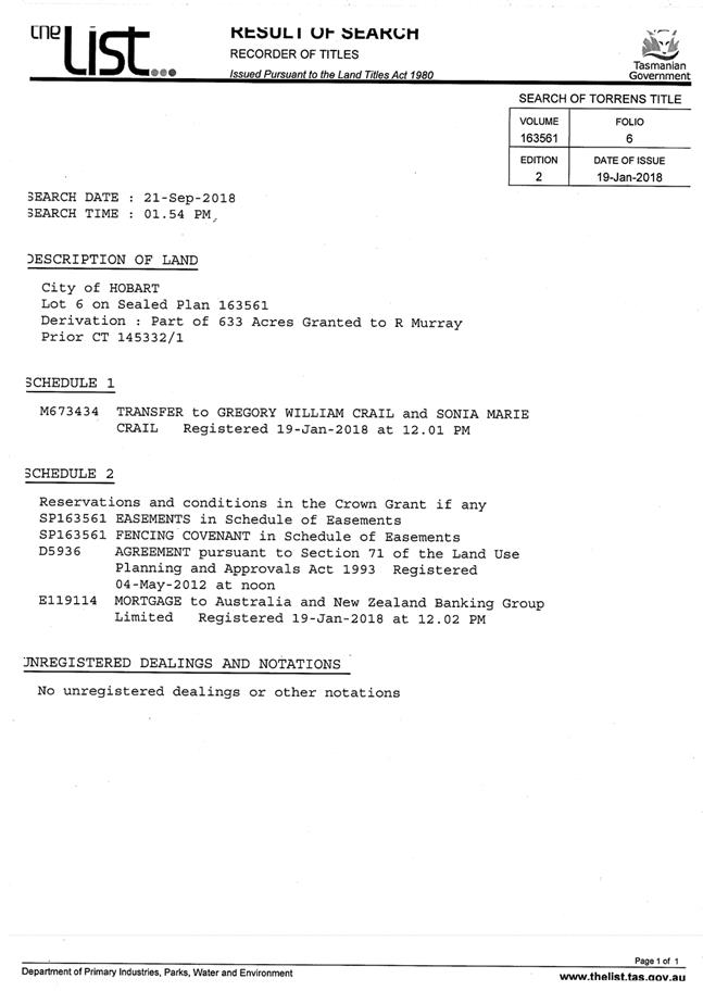
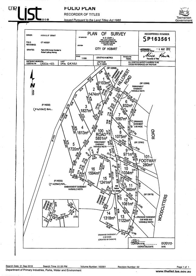
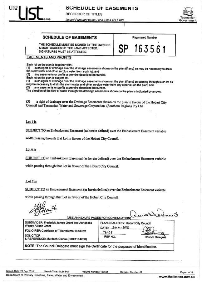
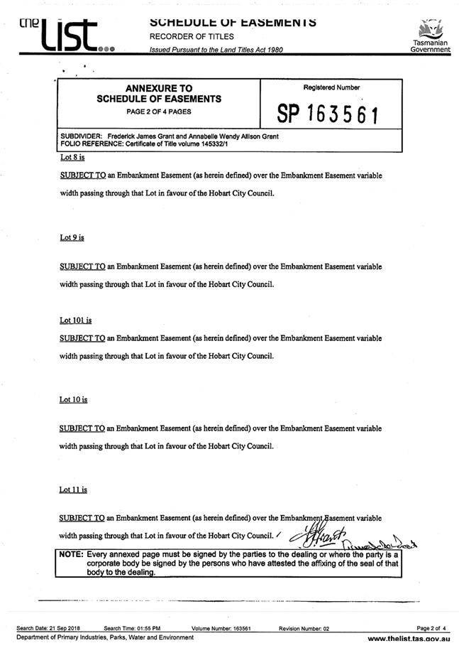
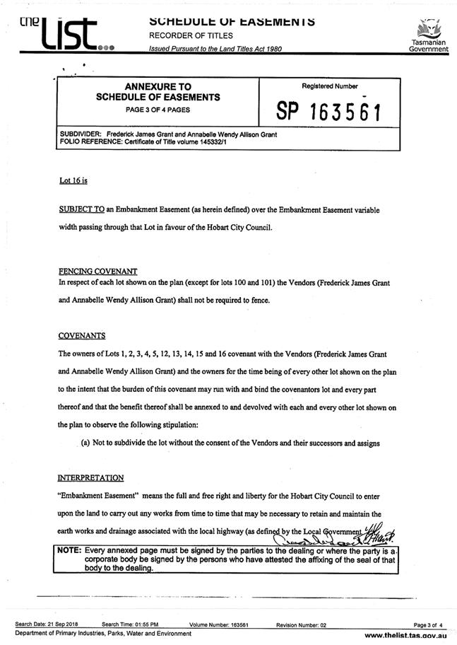
The width and location of the existing Embankment Easement over Lot 6 on SP 163561 is to be amended under the provisions of Section 103 of the Local Government (Building & Miscellaneous) Provisions Act 1993. The amendment to the embankment easement is to be undertaken to the satisfaction of the Council's Director of City Planning prior to the issue of any building consent, building permit and/or plumbing permit pursuant to the Building Act 2016 (if applicable), or the commencement of works on site (whichever occurs first).
Reason for condition
To ensure that the proposed development does not encroach into the Embankment Easement over Lot 6 on SP 163561.
ADVICE
The following advice is provided to you to assist in the implementation of the planning permit that has been issued subject to the conditions above. The advice is not exhaustive and you must inform yourself of any other legislation, bylaws, regulations, codes or standards that will apply to your development under which you may need to obtain an approval. Visit the Council's website for further information.
Prior to any commencement of work on the site or commencement of use the following additional permits/approval may be required from the Hobart City Council.
CONDITION ENDORSEMENT ENGINEERING
All engineering drawings required to be submitted and approved by this planning permit must be submitted to the City of Hobart as a CEP (Condition Endorsement) via the City’s Online Service Development Portal. When lodging a CEP, please reference the PLN number of the associated Planning Application. Each CEP must also include an estimation of the cost of works shown on the submitted engineering drawings. Once that estimation has been confirmed by the City’s Engineer, the following fees are payable for each CEP submitted and must be paid prior to the City of Hobart commencing assessment of the engineering drawings in each CEP:
Value of Building Works Approved by Planning Permit Fee: · Up to $20,000: $150 per application. · Over $20,000: 2% of the value of the works as assessed by the City's Engineer per assessment.
These fees are additional to building and plumbing fees charged under the Building and Plumbing Regulations.
Once the CEP is lodged via the Online Service Development Portal, if the value of building works approved by your planning permit is over $20,000, please contact the City’s Development Engineer on 6238 2715 to confirm the estimation of the cost of works shown on the submitted engineering drawings has been accepted.
Once confirmed, pleased call one of the City’s Customer Service Officers on 6238 2190 to make payment, quoting the reference number (ie. CEP number) of the Condition Endorsement you have lodged. Once payment is made, your engineering drawings will be assessed.
BUILDING PERMIT
You may need building approval in accordance with the Building Act 2016. Click here for more information.
This is a Discretionary Planning Permit issued in accordance with section 57 of the Land Use Planning and Approvals Act 1993.
PLUMBING PERMIT
You may need plumbing approval in accordance with the Building Act 2016, Building Regulations 2016 and the National Construction Code. Click here for more information.
TOLMANS HILL LOCAL AREA PLAN
The Tolmans Hill Local Area Plan (Stage 17A) is available here.
Front fences must not be erected on the property, and side boundary fences must be in accordance with the provisions of the relevant Tolmans Hill Local area Plan.
This approval and subsequent conditions are given in the knowledge that the Part 5 Agreement on the title (CT 163561/6) to the property is effective and binds the applicant to the restrictions and controls of the Local Area Plan.
Plant species listed in Council’s Restricted Plant List: Potentially Invasive Species Generally Unsuitable for Planting in or Adjacent Bushland, Riparian and Coastal Areas (June 2011) must not be planted on the lot (available here).
OCCUPATION OF THE PUBLIC HIGHWAY
You may require a Permit to Open Up and Temporarily Occupy a Highway (for work in the road reserve). Click here for more information.
BUILDING OVER AN EASEMENT
In order to build over the service easement, you will require the written consent of the person on whose behalf the easement was created, in accordance with section 74 of the Building Act 2016.
STORM WATER
Please note that in addition to a building and/or plumbing permit, development must be in accordance with the Hobart City Council’s Hydraulic Services By law. Click here for more information.
WORK WITHIN THE HIGHWAY RESERVATION
Please note development must be in accordance with the Hobart City Council’s Highways By law. Click here for more information.
DRIVEWAY SURFACING OVER HIGHWAY RESERVATION
If a coloured or textured surface is used for the driveway access within the Highway Reservation, the Council or other service provider will not match this on any reinstatement of the driveway access within the Highway Reservation required in the future.
REDUNDANT CROSSOVERS
Redundant crossovers are required to be reinstated under the Hobart City Council’s Highways By law. Click here for more information.
ACCESS
Designed in accordance with LGAT IPWEA – Tasmanian standard drawings. Click here for more information.
CROSS OVER CONSTRUCTION
The construction of the crossover can be undertaken by the Council or by a private contractor, subject to Council approval of the design. Click here for more information.
WEED CONTROL
Effective measures are detailed in the Tasmanian Washdown Guidelines for Weed and Disease Control: Machinery, Vehicles and Equipment (Edition 1, 2004). The guidelines can be obtained from the Department of Primary Industries, Parks, Water and Environment website.
FEES AND CHARGES
Click here for information on the Council's fees and charges.
DIAL BEFORE YOU DIG
Click here for dial before you dig information.
|
Attachment a: PLN-18-696
- 53 HILLCREST ROAD TOLMANS HILL TAS 7007 - Planning Committee or Delegated
Report ⇩ ![]()
Attachment
b: PLN-18-696
- 53 HILLCREST ROAD TOLMANS HILL TAS 7007 - CPC Agenda Documents ⇩ ![]()
|
Item No. 7.2.2 |
Agenda (Open Portion) City Planning Committee Meeting - 24/6/2019 |
Page 181 ATTACHMENT a |

|
Agenda (Open Portion) City Planning Committee Meeting - 24/6/2019 |
Page 210 ATTACHMENT b |
|
Item No. 7.2.2 |
Agenda (Open Portion) City Planning Committee Meeting - 24/6/2019 |
Page 221 ATTACHMENT b |
|
Item No. 7.2.2 |
Agenda (Open Portion) City Planning Committee Meeting - 24/6/2019 |
Page 223 ATTACHMENT b |
|
Item No. 7.2.2 |
Agenda (Open Portion) City Planning Committee Meeting - 24/6/2019 |
Page 224 ATTACHMENT b |
|
Item No. 7.2.2 |
Agenda (Open Portion) City Planning Committee Meeting - 24/6/2019 |
Page 225 ATTACHMENT b |
|
Item No. 7.2.2 |
Agenda (Open Portion) City Planning Committee Meeting - 24/6/2019 |
Page 227 ATTACHMENT b |
|
Item No. 7.2.2 |
Agenda (Open Portion) City Planning Committee Meeting - 24/6/2019 |
Page 230 ATTACHMENT b |
|
Item No. 7.2.3 |
Agenda (Open Portion) City Planning Committee Meeting |
Page 237 |
|
|
24/6/2019 |
|
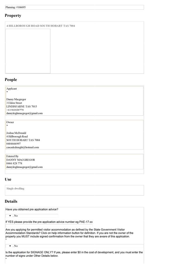
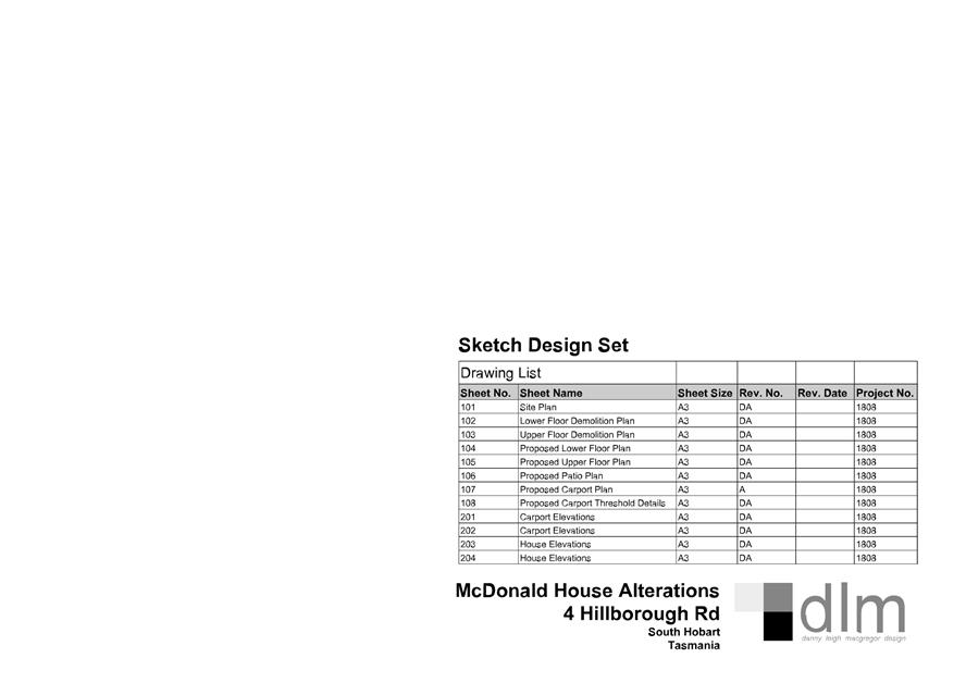
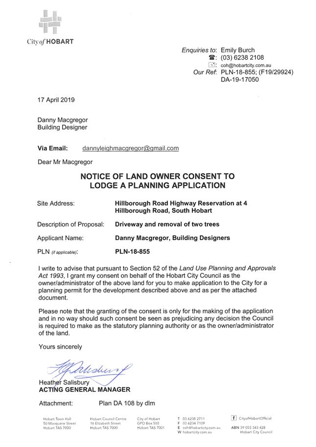
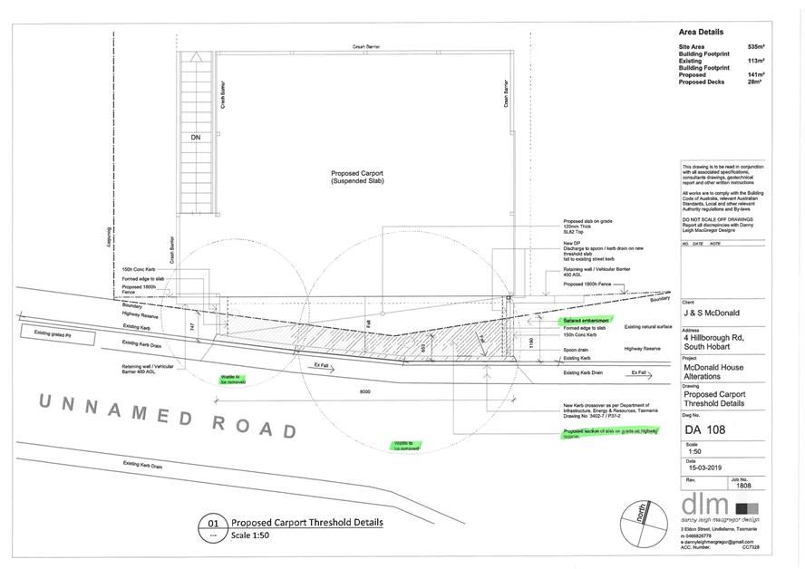
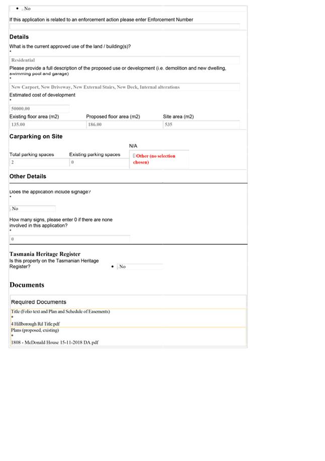
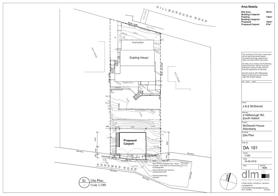
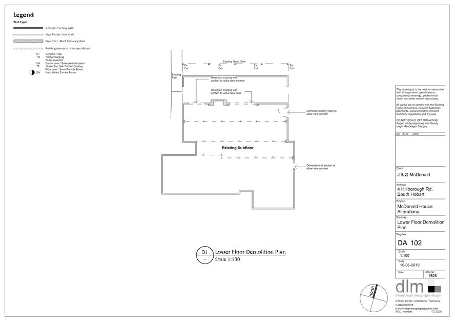
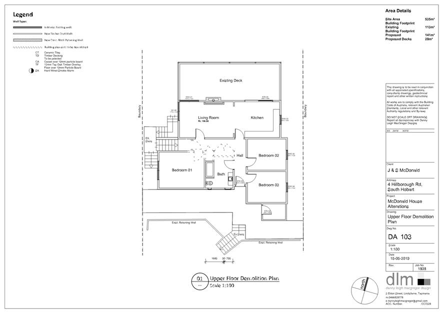
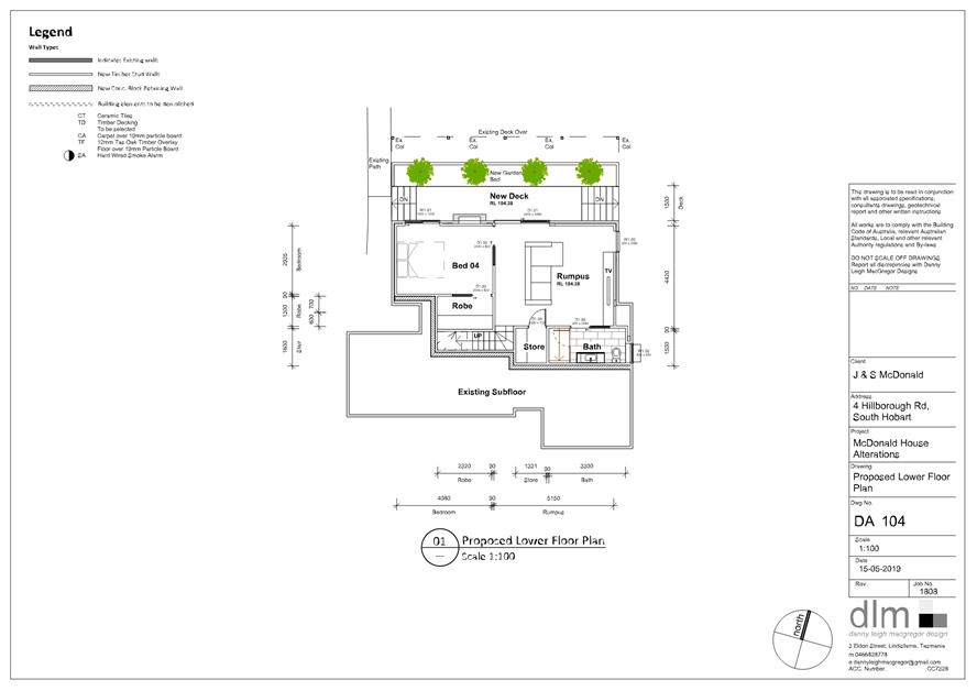
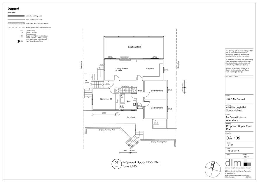
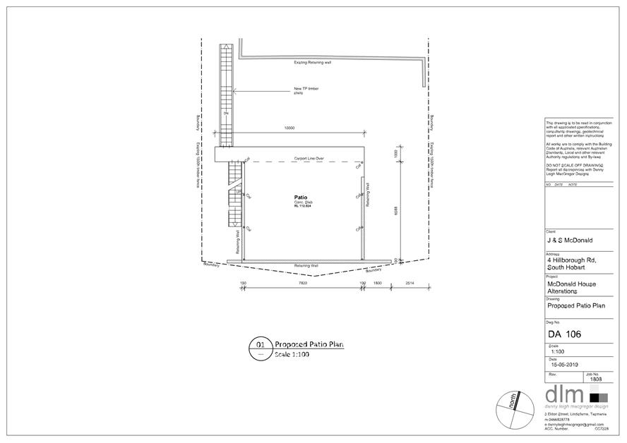
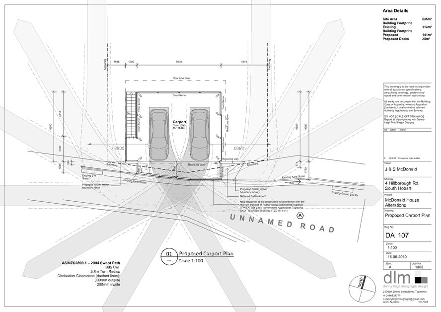
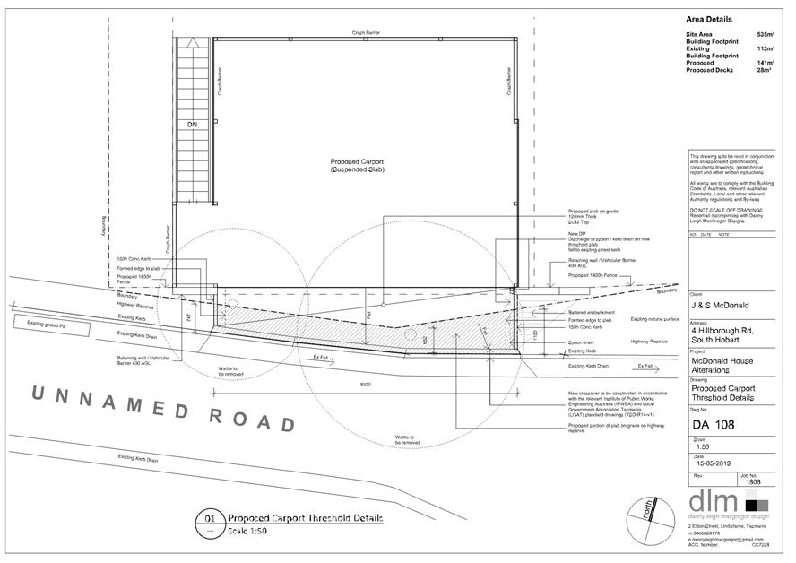
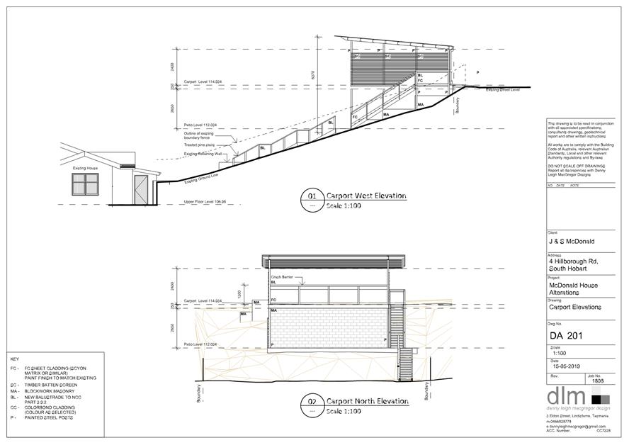
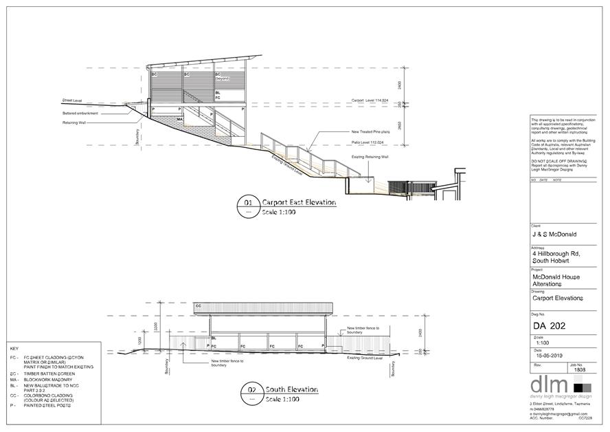
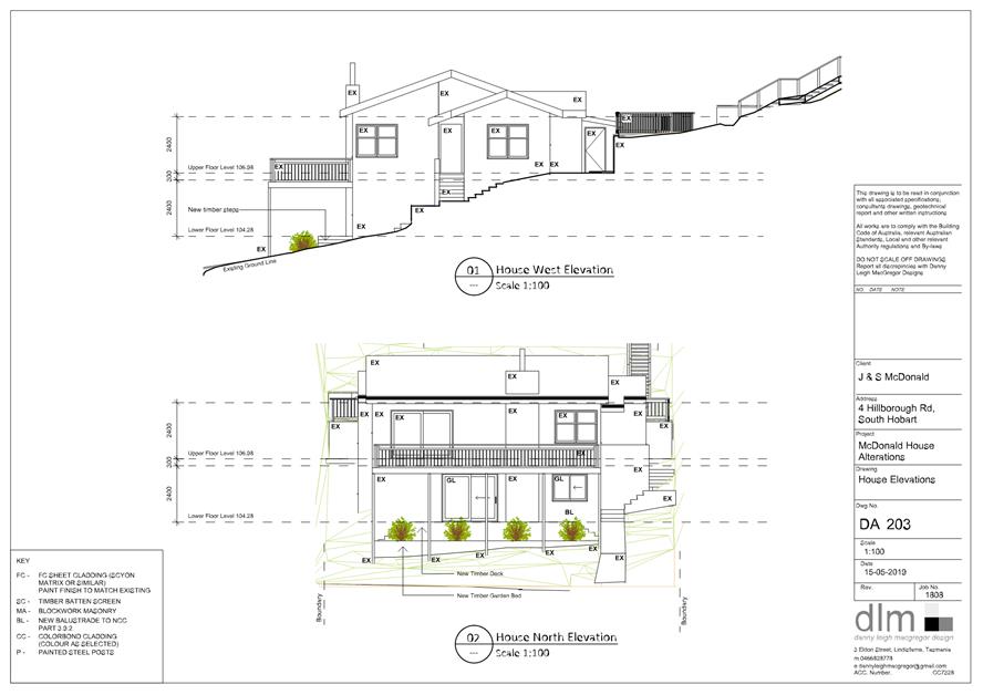
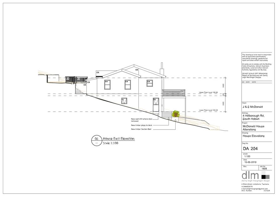
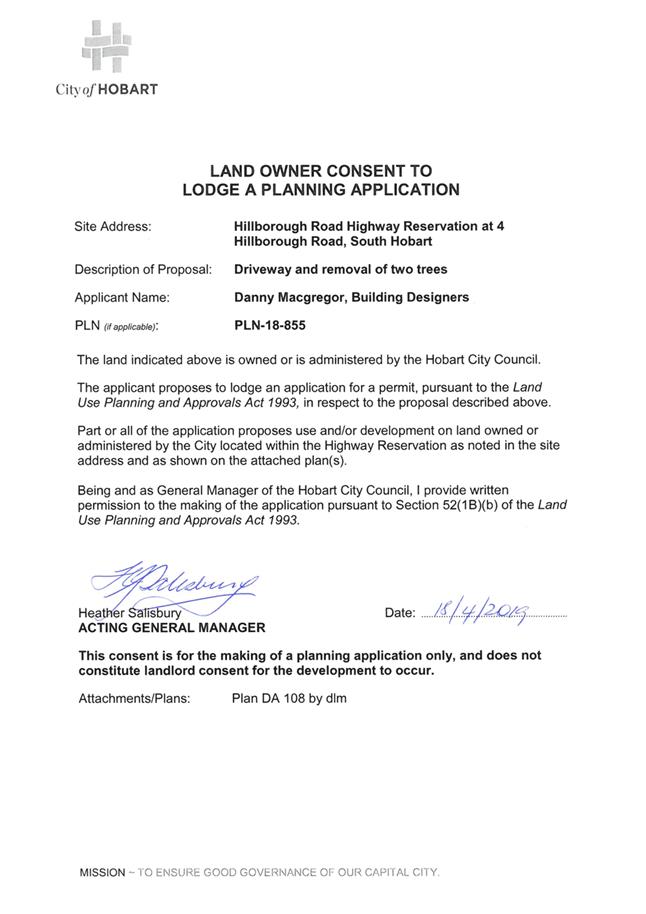
7.2.3 4 Hillborough Road, South Hobart and Adjacent Road Reserve - Partial Demolition, Alterations, Extension and Carport
Address: 4 Hillborough Road, South Hobart and Adjacent Road Reserve
Proposal: Partial Demolition, Alterations, Extension and Carport
Expiry Date: 28 July 2019
Extension of Time: Not applicable
Author: Michael McClenahan
|
REcommendation That pursuant to the Hobart Interim Planning Scheme 2015, the Council approve the application for partial demolition, alterations, extension and carport at 4 Hillborough Road, and adjacent road reserve, South Hobart for the reasons outlined in the officer’s report and a permit containing the following conditions be issued:
GEN
The use and/or development must be substantially in accordance with the documents and drawings that comprise PLN18855 4 HILLBOROUGH ROAD SOUTH HOBART TAS 7004 Final Planning Documents except where modified below.
Reason for condition
To clarify the scope of the permit.
ENG sw1
All stormwater from the proposed development (including but not limited to: roofed areas, ag drains, retaining wall ag drains and impervious surfaces such as driveways and paved areas) must be drained to the Council’s stormwater infrastructure prior to first occupation or commencement of use (whichever occurs first).
Reason for condition
To ensure that stormwater from the site will be discharged to a suitable Council approved outlet.
ENG sw4
Any new stormwater connection must be constructed and any existing abandoned connections sealed by the Council at the owner’s expense, prior to the first occupation.
Detailed engineering drawings must be submitted and approved, prior to commencement of work. The detailed engineering drawings must include:
1. the location of the proposed connection; and 2. the size of the connection appropriate to satisfy the needs of the development.
All work required by this condition must be undertaken in accordance with the approved detailed engineering drawings.
Advice: · The applicant is advised to submit detailed design drawings via a Council City Amenity Division application for a new stormwater connection. If detailed design to satisfy this condition is submitted via the planning condition endorsement process there may be fees associated with the assessment, and once approved the applicant will still need to submit an application for a new stormwater connection with Council City Amenity Division. · Where building / plumbing approval is also required, it is recommended that documentation to satisfy this condition is submitted well before submitting documentation for building/plumbing approval. Failure to address planning condition requirements prior to submitting for building/plumbing approval may result in unexpected delays.
Reason for condition
To ensure the site is drained adequately.
ENG 2b
Prior to the issue of any approval under the Building Act 2016 or the commencement of works on site (whichever occurs first), a certified vehicle barrier design (including site plan with proposed location(s) of installation) prepared by a suitably qualified engineer, compliant with Australian Standard AS/NZS1170.1:2002, must be submitted to and approved by Council.
Advice: · If the development's building approval includes the need for a building permit from the Council, the applicant is advised to submit detailed design of vehicular barrier as part of the building application. If the development's building approval is covered under notifiable work the applicant is advised to submit detailed design of vehicular barrier as a condition endorsement of the planning permit condition. Once the certification has been accepted, the Council will issue a condition endorsement (see general advice on how to obtain condition endorsement).
Reason for condition
To ensure the safety of users of the access driveway and parking module and compliance with the standard.
ENG 2c
Prior to the commencement of use, vehicular barriers must be inspected by a qualified engineer and certification submitted to the Council confirming that the installed vehicular barriers comply with the certified design and Australian Standard AS/NZS1170.1:2002.
Advice: · Certification may be submitted to the Council as part of the Building Act 2016 approval process or via condition endorsement (see general advice on how to obtain condition endorsement).
Reason for condition
To ensure the safety of users of the access driveway and parking module and compliance with the relevant standards.
ENG 3a
The access driveway, ramps and parking module (parking spaces, aisles and manoeuvring area) must be designed and constructed in accordance with Australian Standard AS/NZS2890.1:2004 (including the requirement for vehicle safety barriers where required), or a Council approved alternate design certified by a suitably qualified engineer to provide a safe and efficient access, and enable safe, easy and efficient use.
Advice: · It is advised that designers consider the detailed design of the access and parking module prior to finalising the finished floor level (FFL) of the parking spaces (especially if located within a garage incorporated into the dwelling), as failure to do so may result in difficulty complying with this condition.
Reason for condition
To ensure the safety of users of the access and parking module, and compliance with the relevant Australian Standard.
ENG 3c
The access driveway and parking module (parking spaces, aisles and manoeuvring area) must be constructed in accordance with the design drawings approved by Conditions ENG r1 and ENGR 3.
Prior to the first occupation, documentation by a suitably qualified engineer certifying that the access driveway and parking module has been constructed in accordance with the above drawings must be lodged with the Council.
Advice: · Certification may be submitted to Council as part of the Building Act 2016 approval process or via condition endorsement (see general advice on how to obtain condition endorsement)
Reason for condition
ENG 1
Any damage to council infrastructure resulting from the implementation of this permit, must, at the discretion of the Council:
1. Be met by the owner by way of reimbursement (cost of repair and reinstatement to be paid by the owner to the Council); or 2. Be repaired and reinstated by the owner to the satisfaction of the Council.
A photographic record of the Council's infrastructure adjacent to the subject site must be provided to the Council prior to any commencement of works.
A photographic record of the Council’s infrastructure (e.g. existing property service connection points, roads, buildings, stormwater, footpaths, driveway crossovers and nature strips, including if any, preexisting damage) will be relied upon to establish the extent of damage caused to the Council’s infrastructure during construction. In the event that the owner/developer fails to provide to the Council a photographic record of the Council’s infrastructure, then any damage to the Council's infrastructure found on completion of works will be deemed to be the responsibility of the owner.
Reason for condition
To ensure that any of the Council's infrastructure and/or siterelated service connections affected by the proposal will be altered and/or reinstated at the owner’s full cost.
ENG r1
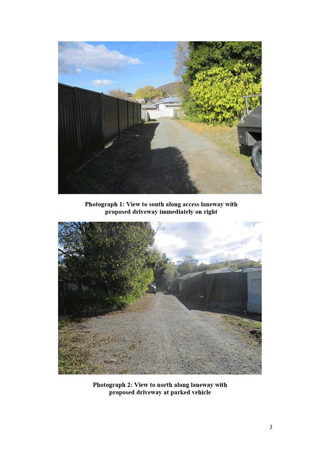
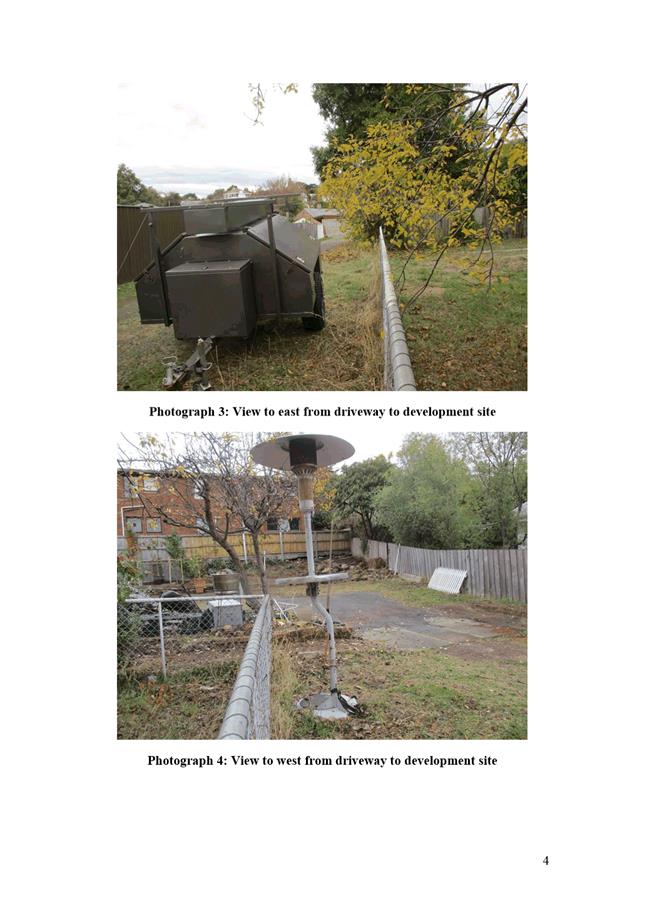
The footings and driveway deck within the highway reservation of the unnamed laneway at the southern end of the site must not undermine the stability and integrity of the highway reservation and its infrastructure.
Detailed design drawings, structural certificates and associated geotechnical assessments of the footings and driveway deck within the highway reservation must be submitted and approved prior to the commencement of work and must:
1. Be prepared and certified by a suitable qualified person and experienced engineer. 2. Not undermine the stability of the highway reservation. 3. Take into account and reference accordingly any geotechnical findings. 4. Detail the design and location of the footings. 5. Include drawings and structural certificates which notes the driveway deck will be supported independently of the existing Council road infrastructure and not transfer additional loads onto the existing Council road infrastructure. 6. Include pedestrian handrails or similar on the driveway deck where the vertical drop off is greater than 900mm located within the highway reservation. 7. Include structure certificate and drawings which notes the driveway slab will not transfer additional loads onto the existing retaining wall and that the footings will not undermine the highway reservation. 8. Ensure that any structural certificates and drawings are notated in accordance with the above.
All work required by this condition must be undertaken in accordance with the approved detailed design drawings, structural certificates and associated geotechnical assessments.
Advice: · The applicant is required submit detailed design documentation to satisfy this condition via Council's planning condition endorsement process (noting there is a fee associated with condition endorsement approval of engineering drawings [see general advice on how to obtain condition endorsement and for fees and charges]). This is a separate process to any building approval under the Building Act 2016. · Failure to address condition endorsement requirements prior to submitting for building approval may result in unexpected delays. Reason for condition
To ensure that the stability and integrity of the Council’s highway reservation is not compromised by the development.
ENGR 3
The proposed driveway crossover within the highway reservation must be designed and constructed in accordance with Urban TSDR09v1 – Urban Roads Driveways, TSD R14v1 Type KC vehicular crossing and Urban Roads Footpaths TSDR11v1 prior to the commencement of the use.
Design drawings must be submitted and approved prior to the commencement of work (or any approval under the Building Act 2016). The design drawings must:
1. Show the cross and long section of the driveway crossover within the highway reservation and onto the property. 2. Detail existing and new services/infrastructure (ie light poles) at or near the proposed driveway crossover showing clearances with reference to the requirements of the relevant authority. 3. Detail the removal of the vegetation. 4. Be prepared and certified by a suitable qualified person, to satisfy the above requirement.
All work required by this condition must be undertaken in accordance with the approved design drawings.
Advice: · The applicant is required submit detailed design documentation to satisfy this condition via Council's planning condition endorsement process (noting there is a fee associated with condition endorsement approval of engineering drawings [see general advice on how to obtain condition endorsement and for fees and charges]). This is a separate process to any building approval under the Building Act 2016. · Failure to address condition endorsement requirements prior to submitting for building approval may result in unexpected delays.
Reason for condition
To ensure that works will comply with the Council’s standard requirements.
ENV 1
Sediment and erosion control measures sufficient to prevent sediment from leaving the site must be installed prior to any disturbance of the site, and maintained until all areas of disturbance have been stabilised or revegetated.
Advice: For further guidance in preparing a Soil and Water Management Plan – in accordance with Fact sheet 3 Derwent Estuary Program click here.
Reason for condition
To avoid the sedimentation of roads, drains, natural watercourses, Council land that could be caused by erosion and runoff from the development, and to comply with relevant State legislation.
OPS s1
Prior to the issue of any consent under the Building Act 2016, or the commencement of any work on site, whichever occurs first, a payment of $800 is to be made to City of Hobart for removal of the street tree, Acacia dealbata Silver Wattle, in the road reserve of the unnamed laneway at the southern end of the site in the area of the proposed carport.
Advice: · To arrange payment of the tree removal fee, please contact the Council's Open Space Unit on 6238 2887.
Reason for condition
To compensate for the loss of the amenity value of the tree on public land.
ADVICE
The following advice is provided to you to assist in the implementation of the planning permit that has been issued subject to the conditions above. The advice is not exhaustive and you must inform yourself of any other legislation, bylaws, regulations, codes or standards that will apply to your development under which you may need to obtain an approval. Visit the Council's website for further information.
Prior to any commencement of work on the site or commencement of use the following additional permits/approval may be required from the Hobart City Council.
CONDITION ENDORSEMENT ENGINEERING
All engineering drawings required to be submitted and approved by this planning permit must be submitted to the City of Hobart as a CEP (Condition Endorsement) via the City’s Online Service Development Portal. When lodging a CEP, please reference the PLN number of the associated Planning Application. Each CEP must also include an estimation of the cost of works shown on the submitted engineering drawings. Once that estimation has been confirmed by the City’s Engineer, the following fees are payable for each CEP submitted and must be paid prior to the City of Hobart commencing assessment of the engineering drawings in each CEP:
Value of Building Works Approved by Planning Permit Fee: · Up to $20,000: $150 per application. · Over $20,000: 2% of the value of the works as assessed by the City's Engineer per assessment.
These fees are additional to building and plumbing fees charged under the Building and Plumbing Regulations.
Once the CEP is lodged via the Online Service Development Portal, if the value of building works approved by your planning permit is over $20,000, please contact the City’s Development Engineer on 6238 2715 to confirm the estimation of the cost of works shown on the submitted engineering drawings has been accepted.
Once confirmed, pleased call one of the City’s Customer Service Officers on 6238 2190 to make payment, quoting the reference number (ie. CEP number) of the Condition Endorsement you have lodged. Once payment is made, your engineering drawings will be assessed.
BUILDING PERMIT
You may need building approval in accordance with the Building Act 2016. Click here for more information.
This is a Discretionary Planning Permit issued in accordance with section 57 of the Land Use Planning and Approvals Act 1993.
PLUMBING PERMIT
You may need plumbing approval in accordance with the Building Act 2016, Building Regulations 2016 and the National Construction Code. Click here for more information.
OCCUPATION OF THE PUBLIC HIGHWAY
You may require a Permit to Open Up and Temporarily Occupy a Highway (for work in the road reserve). Click here for more information.
NEW SERVICE CONNECTION
Please contact the Hobart City Council's City Infrastructure Division to initiate the application process for your new stormwater connection.
STORMWATER
Please note that in addition to a building and/or plumbing permit, development must be in accordance with the Hobart City Council’s Hydraulic Services By law. Click here for more information.
WORK WITHIN THE HIGHWAY RESERVATION
Please note development must be in accordance with the Hobart City Council’s Highways By law. Click here for more information.
DRIVEWAY SURFACING OVER HIGHWAY RESERVATION
If a coloured or textured surface is used for the driveway access within the Highway Reservation, the Council or other service provider will not match this on any reinstatement of the driveway access within the Highway Reservation required in the future.
ACCESS
Designed in accordance with LGAT IPWEA – Tasmanian standard drawings. Click here for more information.
CROSS OVER CONSTRUCTION
The construction of the crossover can be undertaken by the Council or by a private contractor, subject to Council approval of the design. Click here for more information.
WEED CONTROL
Effective measures are detailed in the Tasmanian Washdown Guidelines for Weed and Disease Control: Machinery, Vehicles and Equipment (Edition 1, 2004). The guidelines can be obtained from the Department of Primary Industries, Parks, Water and Environment website.
NOISE REGULATIONS
Click here for information with respect to noise nuisances in residential areas.
WASTE DISPOSAL
It is recommended that the developer liaise with the Council’s Cleansing and Solid Waste Unit regarding reducing, reusing and recycling materials associated with demolition on the site to minimise solid waste being directed to landfill.
Further information regarding waste disposal can also be found on the Council’s website.
FEES AND CHARGES
Click here for information on the Council's fees and charges.
DIAL BEFORE YOU DIG
Click here for dial before you dig information.
|
Attachment
a: PLN-18-855
- 4 HILLBOROUGH ROAD SOUTH HOBART TAS 7004 - Planning Committee or Delegated
Report ⇩ ![]()
Attachment
b: PLN-18-855
- 4 HILLBOROUGH ROAD SOUTH HOBART TAS 7004 - CPC Agenda Documents ⇩ ![]()
|
Item No. 7.2.3 |
Agenda (Open Portion) City Planning Committee Meeting - 24/6/2019 |
Page 248 ATTACHMENT a |
|
Agenda (Open Portion) City Planning Committee Meeting - 24/6/2019 |
Page 271 ATTACHMENT b |

|
Item No. 7.2.3 |
Agenda (Open Portion) City Planning Committee Meeting - 24/6/2019 |
Page 276 ATTACHMENT b |
|
Item No. 7.2.3 |
Agenda (Open Portion) City Planning Committee Meeting - 24/6/2019 |
Page 290 ATTACHMENT b |
|
Item No. 7.2.3 |
Agenda (Open Portion) City Planning Committee Meeting - 24/6/2019 |
Page 291 ATTACHMENT b |
|
Item No. 7.2.4 |
Agenda (Open Portion) City Planning Committee Meeting |
Page 292 |
|
|
24/6/2019 |
|
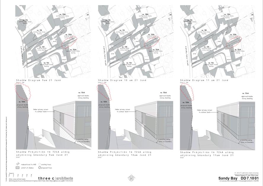
7.2.4 PLN-17-1069 – 720 Sandy Bay Road
and 718a Sandy Bay Road, Sandy Bay -
Demolition and Two Multiple Dwellings
Memorandum of the Manager Development Appraisal of 19 June 2019 and attachments.
Delegation: Council
|
Item No. 7.2.4 |
Agenda (Open Portion) City Planning Committee Meeting |
Page 294 |
|
|
24/6/2019 |
|

Memorandum: City Planning Committee
PLN-17-1069 – 720 Sandy Bay Road
and 718a Sandy Bay Road, Sandy Bay -
Demolition and Two Multiple Dwellings
This memorandum relates to planning application PLN-17-1069 proposing demolition and two multiple dwellings at 720 Sandy Bay Road and 718A Sandy Bay Road, Sandy Bay.
The
application proposes the demolition of the existing dwelling and carport on
720 Sandy Bay Road and the construction of two new dwellings and two garages on
that property. The proposal includes 718A Sandy Bay Road due to a
proposed new
stormwater connection to the existing Council stormwater main running through
that property.
The proposal generates discretion under the Hobart Interim Planning Scheme 2015 in relation to setbacks and building envelope, site coverage and private open space, waste storage for multiple dwellings, frontage fences, residential density for multiple dwellings, siting buildings close to the Lower Sandy Bay Escarpment, and vehicular access and passing.
Thirty seven representations (thirty six objecting to and one supporting the proposal) were received during the application’s public notification period. Those objecting raised concerns including overshadowing and visual bulk, site coverage and density, privacy, the fairness of the planning process and erosion.
The report at Attachment A to this memorandum contains the officer assessment of the proposal against the Hobart Interim Planning Scheme 2015 and recommends approval subject to conditions.
The application was considered by the Council’s City Planning Committee at its meeting of 29 April 2019. At that meeting, the Committee resolved as follows:
That the item be deferred to a
subsequent City Planning Committee meeting for the purposes of seeking further
advice to ascertain if a reduction in the ceiling heights of the proposed
dwelling at 720A Sandy Bay Road would reduce the impact of overshadowing upon
the neighbouring property to the south.
The applicant has provided a series of shadow diagrams showing the shadows associated with the proposed dwelling at 720A Sandy Bay Road (the lower proposed dwelling, closest to the River Derwent) at five lower heights in 100mm increments (ie. 100mm lower, 200mm lower, 300mm lower, 400mm lower and 500mm lower than the 9300mm maximum height proposed). The diagrams show the shadows associated with those heights at 9am, 10am, 11am, 12 noon and 3pm on June 21.
The applicant has also provided shadow diagrams showing the proposed dwelling at 720A Sandy Bay Road with a maximum building height of 8500mm, achieved by reducing the building by 500mm in height and 600mm in length from its eastern (River Derwent) end.
These shadow diagrams have been peer reviewed as being accurate by a third party (Another Perspective Drafting and Design).
While the officer recommendation (as detailed in the officer report at Attachment A) is for approval of the proposal as advertised, if Elected Members prefer the proposed dwelling at 720A Sandy Bay Road to have a lower height, a condition requiring that outcome has been prepared.
Background
The application was originally advertised in June/July 2018, received 15 representations and was presented as agenda item 7.1.1 to the Council’s City Planning Committee on 27 August 2018 with an officer recommendation for approval. At that meeting, the accuracy of the proposal plans, and in particular the sun shadow information, was brought into question, and the Committee recommended that the application be refused on overshadowing and visual impact grounds. At the subsequent Council meeting of 3 September 2018, and in response to a request to defer by the applicant, the application was deferred in the following terms:
That the item be deferred for two weeks at the request of the applicant.
The applicant sought deferral of the application to enable confirmation of the accuracy or otherwise of the proposal plans, having particular regard to the accuracy of the depiction of the dwellings to the south of the application site, and the potential impacts this proposal will have on them.
The plans were referred to a third party (Another Perspective Drafting and Design) for independent verification. They advised that the ground levels shown on this application and a recent application for the adjacent property at 724 Sandy Bay Road were not consistent. This information was conveyed back to the applicant for consideration and a response.
Following a number of discussions and questions regarding various aspects of the plans for both the application site and the adjacent property to the south, the discrepancies were resolved, and amended plans replacing the original set were submitted by the applicant for confirmation, re-advertising, and assessment.
The amended plans were again independently reviewed by Another Perspective Drafting and Design prior to being publicly advertised. They verified that the amended plans (those the subject of the attached assessment report) now accurately reflect the natural ground lines, the approval for the development that has commenced on the adjacent property, the original dwelling on the adjacent property, and the shadowing impacts the proposal will have on the adjacent dwellings.
The result of the corrected plans is that the maximum building height has increased from 9.0m to 9.3m for the waterside dwelling and 7.1m to 7.38m for the road side dwelling, and subsequently the sun shadow impacts are greater than was previously demonstrated.
This amended set of plans are the basis of advertising, the assessment in the officer’s report attached to this memorandum and determination of the proposal.
Conclusion
The report at Attachment A to this memorandum contains the officer assessment of the proposal against the Hobart Interim Planning Scheme 2015 and recommends approval subject to conditions.
Following extensions of time being granted by the applicant, the application is due to expire on 16 August 2019. Due to the number of representations received, delegation to determine the application rests with the Council.
As requested by the City Planning Committee’s deferral of the application on 29 April 2019, the applicant has provided a series of shadow diagrams showing the shadows associated with the proposed dwelling at 720A Sandy Bay Road (the lower proposed dwelling, closest to the River Derwent) at a series of lower heights (Attachment C). These shadow diagrams have been peer reviewed as being accurate by a third party (Another Perspective Drafting and Design).
While the officer recommendation (as detailed in the officer report at Attachment A) is for approval of the proposal as advertised, if Elected Members prefer the proposed dwelling at 720A Sandy Bay Road to have a lower height than that shown on the advertised plans, a condition requiring that outcome has been prepared.
|
That: That pursuant to the Hobart Interim Planning Scheme 2015, the Council approve the application for demolition and two multiple dwellings at 720 Sandy Bay Road and 718A Sandy Bay Road, Sandy Bay for the reasons outlined in the officer’s report and a permit containing the following conditions be issued:
GEN
TW
PLN s1
PLN s4
1. Darker cladding for the lower level of the southern elevation of the waterside dwelling. 2. Lighter, textured cladding for the upper level of the southern elevation of the waterside dwelling.
ENG sw1
Reason for
condition ENG sw4
1. the location of the proposed connection; and 2. the size of the connection appropriate to satisfy the needs of the development.
· The applicant is advised to submit detailed design drawings via a Council City Amenity Division application for a new stormwater connection. If detailed design to satisfy this condition is submitted via the planning condition endorsement process there may be fees associated with the assessment, and once approved the applicant will still need to submit an application for a new stormwater connection with Council City Amenity Division. · Where building / plumbing approval is also required, it is recommended that documentation to satisfy this condition is submitted well before submitting documentation for building/plumbing approval. Failure to address planning condition requirements prior to submitting for building/plumbing approval may result in unexpected delays. · If the proposed stormwater connection works will occur on third party property, the applicant is advised that they are required (seperate to this planning permit) to obtain the relevant permissions necessary under any other Act in order to undertake the works.
ENG 2a
· The Council does not consider a slope greater than 1 in 4 to constitute a lower level as described in AS/NZS 2890.1:2004 Section 2.4.5.3. Slopes greater than 1 in 4 will require a vehicular barrier or wheel stop. · Designers are advised to consult the National Construction Code 2016 to determine if pedestrian handrails or safety barriers compliant with the NCC2016 are also required in the parking module this area may be considered as a path of access to a building.
ENG 2b
· If the development's building approval includes the need
for a Building Permit from Council, the applicant is advised to submit
detailed design of vehicular barrier as part of the Building Application.
ENG 2c
ENG 3c
· Certification may be submitted to Council as part of the Building Act 2016 approval process or via condition endorsement (see general advice on how to obtain condition endorsement)
ENG 4
ENG 5
ENG 1
ENG 13
1. Compliance with Australian/NZ Standard, Parking facilities Part 1: Off-street car parking AS/NZS 2890.1: 2004 Fig 3.3; or 2. Increasing the gate opening width to 5m; or 3. Increasing the transparency of fencing/gate/wall for at least 1m on each side of driveway so that those sections of fencing are at least 50% transparent; or 4. Setting gates/fence/wall back 1m from the front property boundary for at least 1m on each side of the driveway.
· Once the amended drawing has been approved the Council will issue a condition endorsement (see general advice on how to obtain condition endorsement). · Where building approval is also required, it is recommended that documentation for condition endorsement be submitted well before submitting documentation for building approval. Failure to address condition endorsement requirements prior to submitting for building approval may result in unexpected delays.
ENGR 3
1. Urban - TSD-R09-v1 – Urban Roads Driveways and TSD R17-v1 Plinth and Grate vehicular crossing; and 2. Footpath - Urban Roads Footpaths TSD-R11-v1.
ENG s1
ENV 2
ADVICE
CONDITION ENDORSEMENT ENGINEERING
· Up to $20,000: $150 per application. · Over $20,000: 2% of the value of the works as assessed by the City's Engineer per assessment.
BUILDING PERMIT
PLUMBING PERMIT
OCCUPATION OF THE PUBLIC HIGHWAY
NEW SERVICE CONNECTION
STORMWATER
WORK WITHIN THE HIGHWAY RESERVATION
REDUNDANT CROSSOVERS
ACCESS
STORM WATER / ROADS / ACCESS
WEED CONTROL
WASTE DISPOSAL
FEES AND CHARGES
DIAL BEFORE YOU DIG
|
As signatory to this report, I certify that, pursuant to Section 55(1) of the Local Government Act 1993, I hold no interest, as referred to in Section 49 of the Local Government Act 1993, in matters contained in this report.
|
Rohan Probert Manager Development Appraisal |
|
Date: 19 June 2019
File Reference: F19/79448
Attachment a: PLN-17-1069
- 720 SANDY BAY ROAD SANDY BAY TAS 7005 - Planning Committee or Delegated
Report ⇩ ![]()
Attachment
b: PLN-17-1069
- 720 SANDY BAY ROAD SANDY BAY TAS 7005 - CPC Agenda Documents (second round) ⇩ ![]()
Attachment
c: PLN-17-1069
- 720A Sandy Bay Road - Additional sun shadow diagrams showing 720A Sandy Bay
Road at lower heights as requested by City Planning Committee deferral of 29
April 2019 ⇩ ![]()
|
Item No. 7.2.4 |
Agenda (Open Portion) City Planning Committee Meeting - 24/6/2019 |
Page 306 ATTACHMENT a |
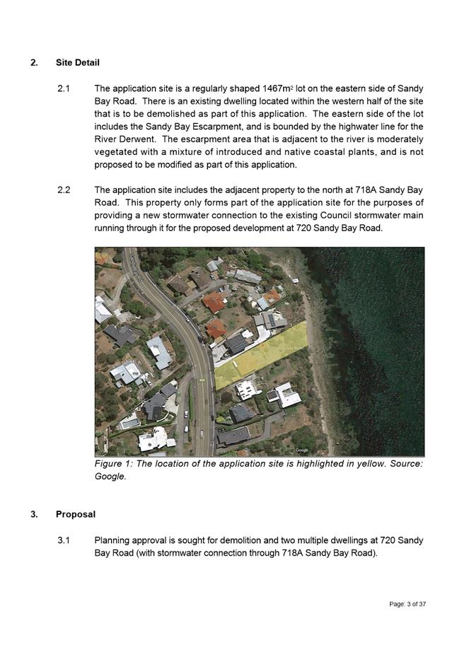
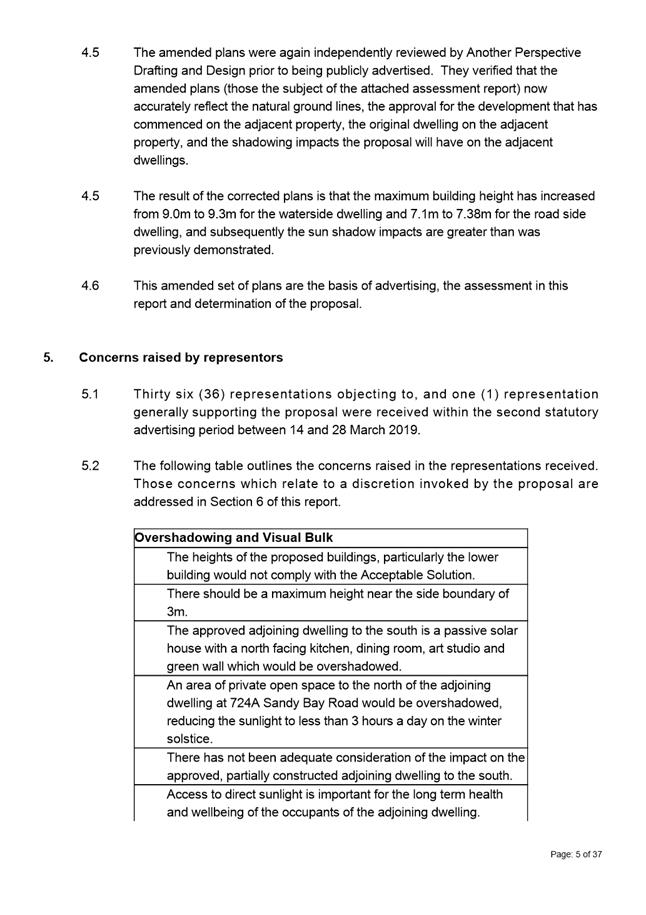
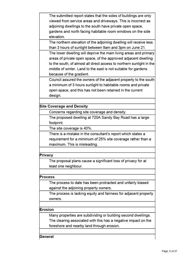
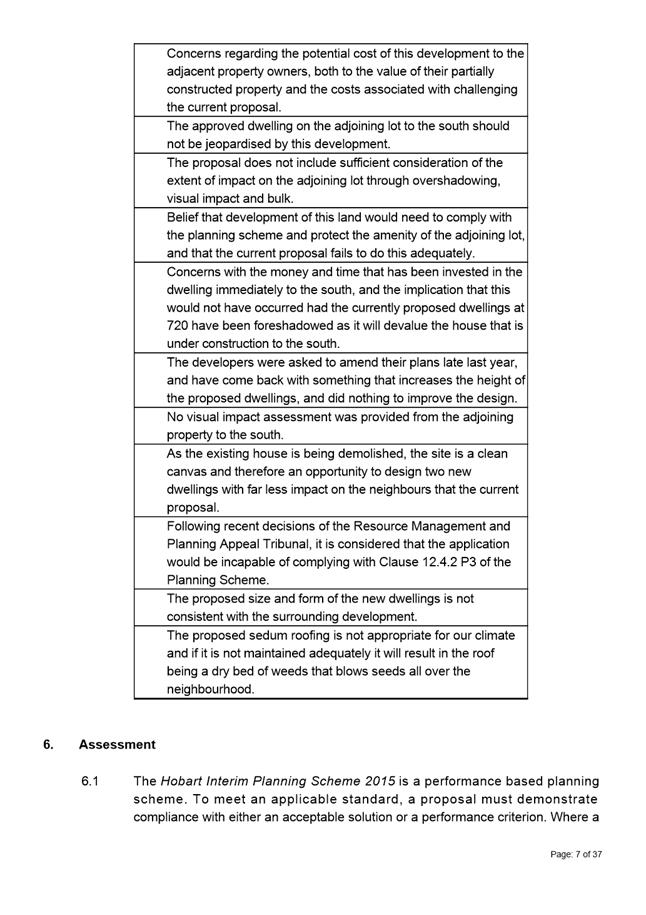
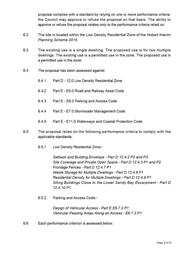
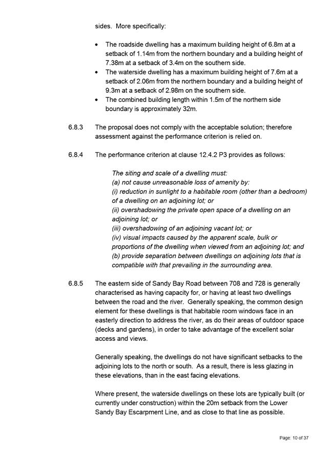
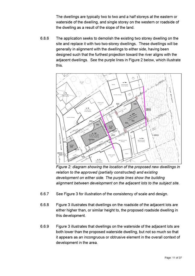
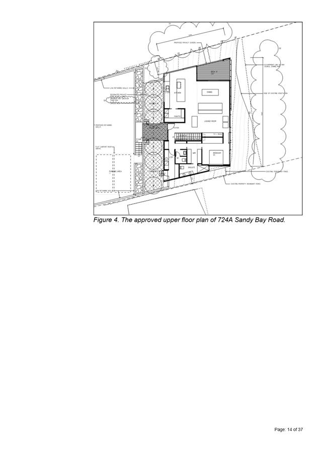
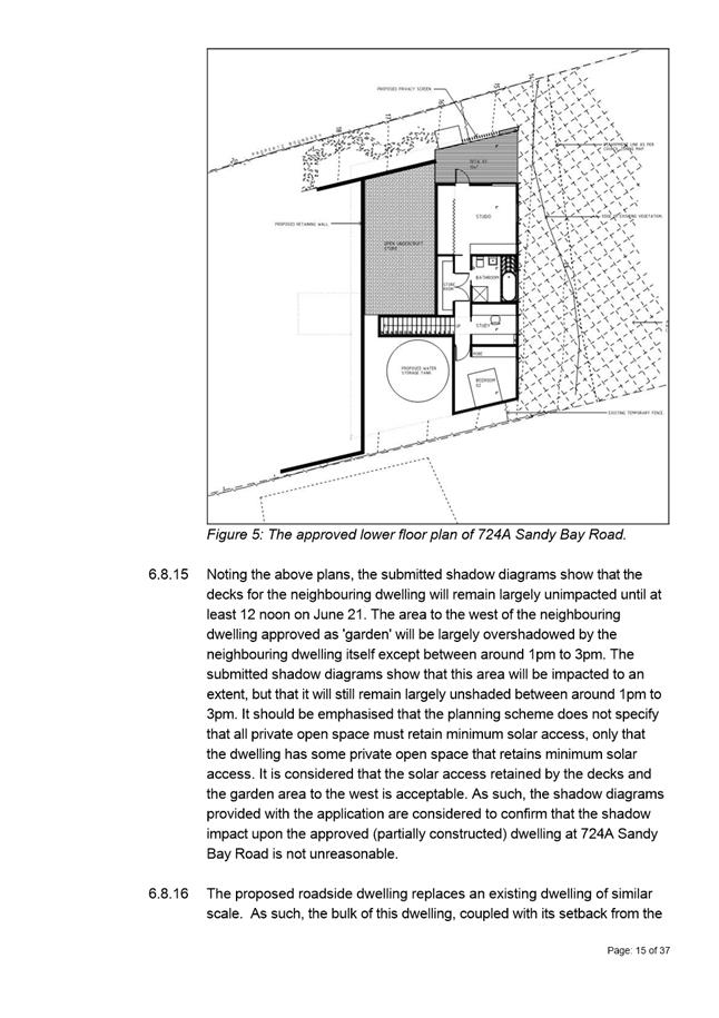

|
Agenda (Open Portion) City Planning Committee Meeting - 24/6/2019 |
Page 342 ATTACHMENT b |
|
Item No. 7.2.4 |
Agenda (Open Portion) City Planning Committee Meeting - 24/6/2019 |
Page 344 ATTACHMENT b |
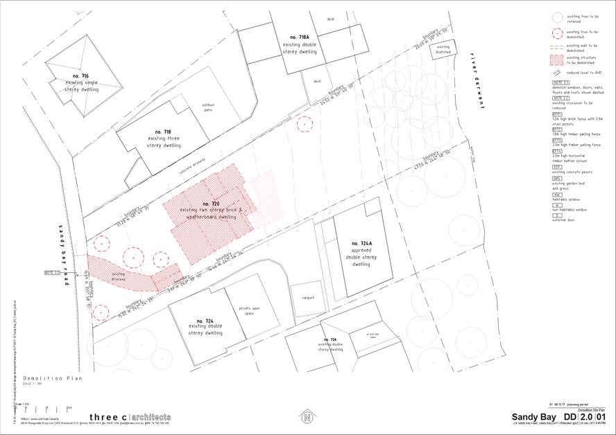
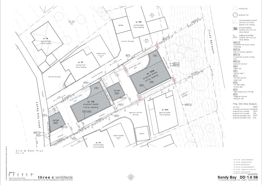
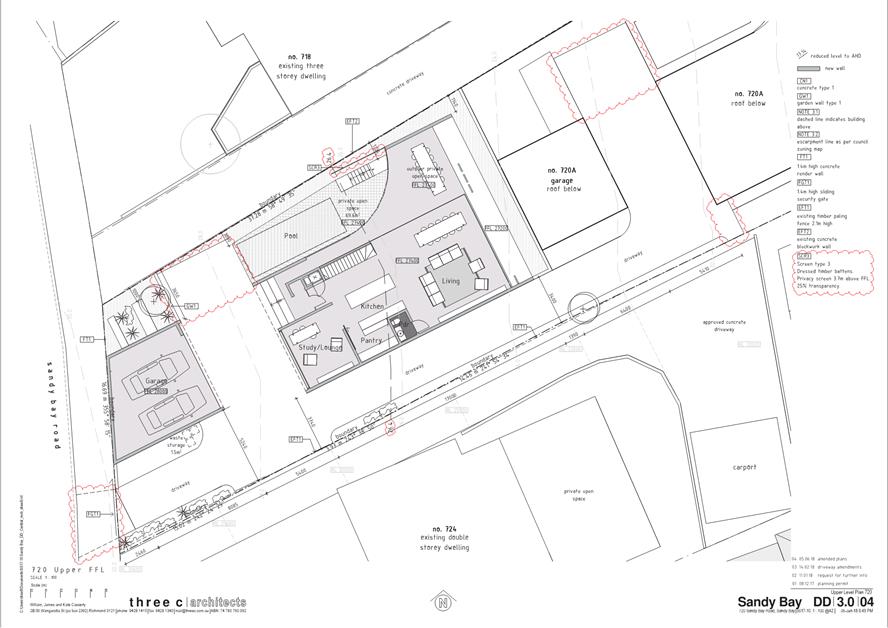
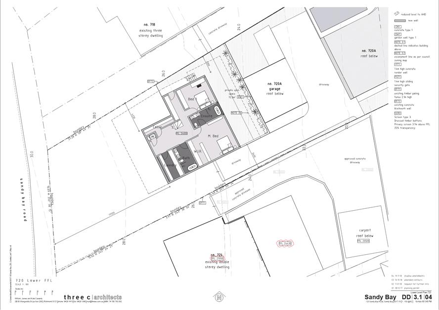
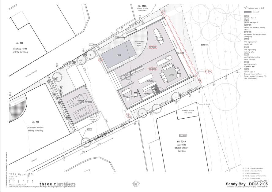
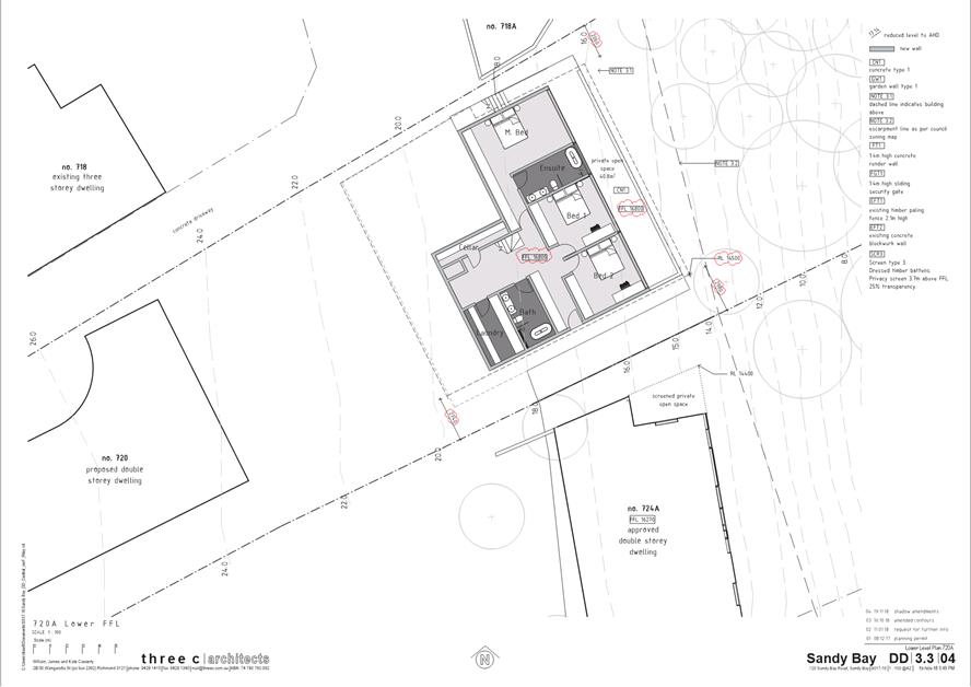
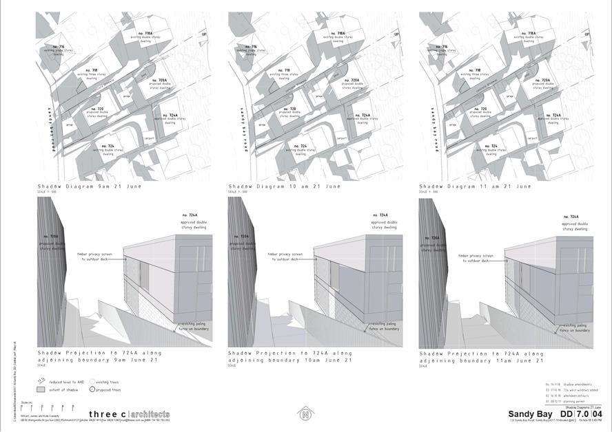
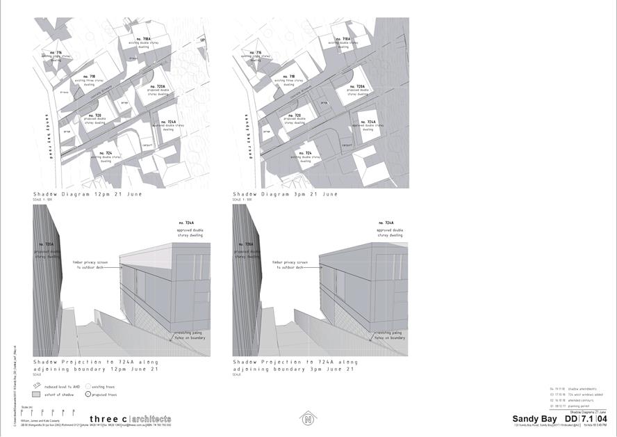
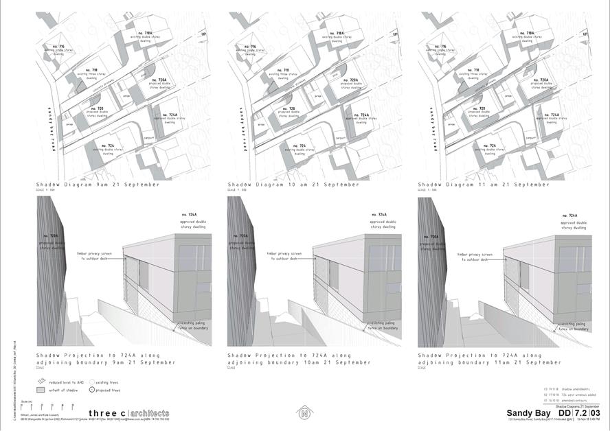
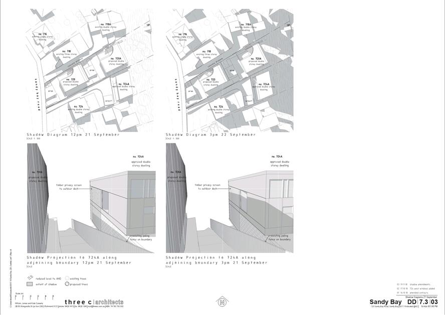
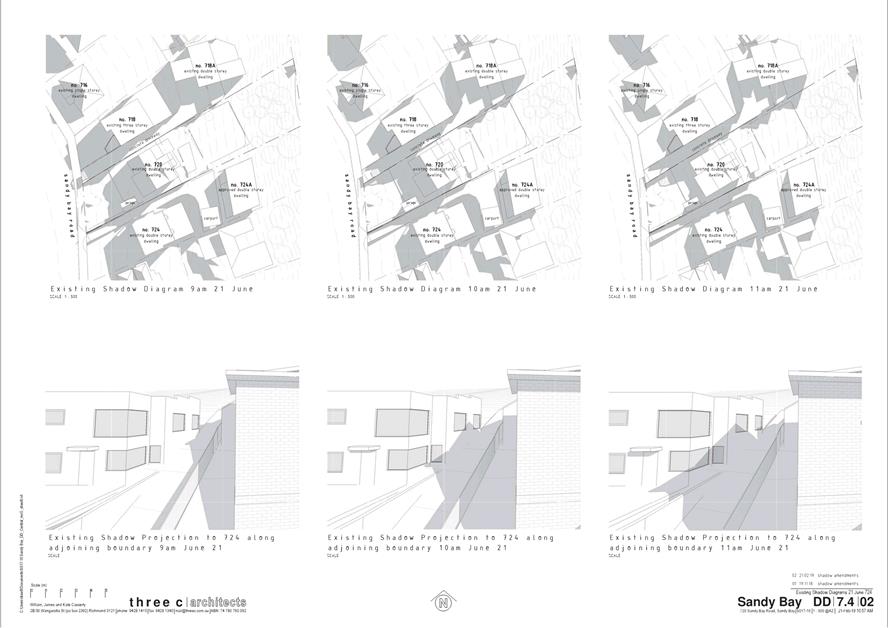
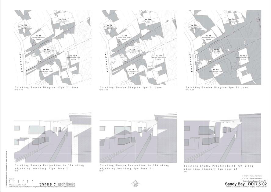
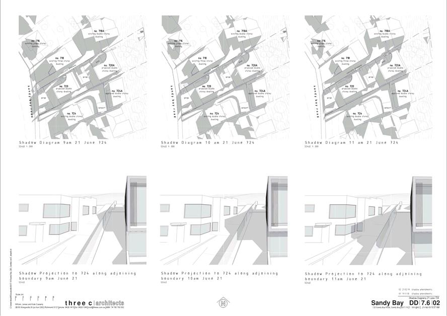
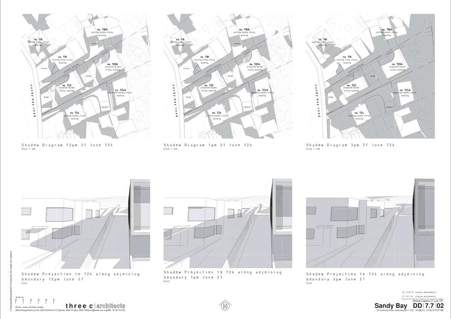
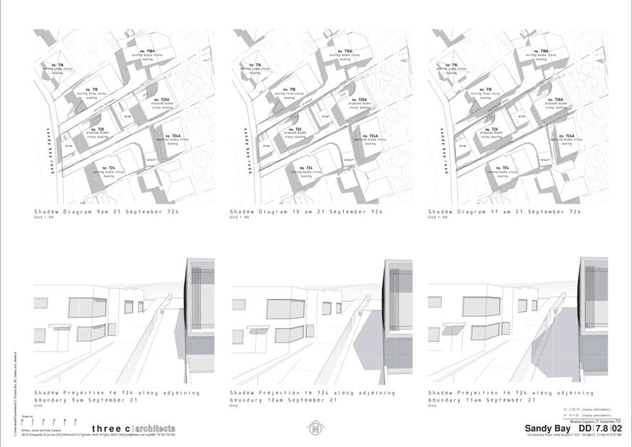
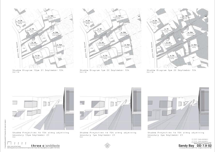
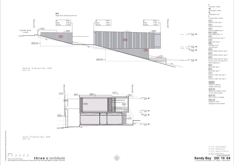
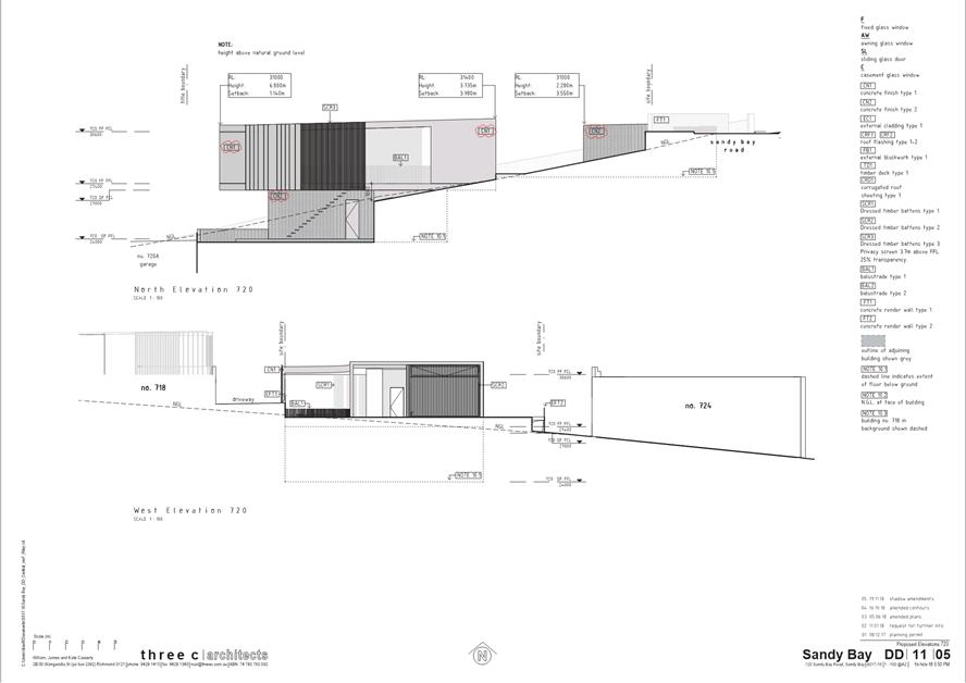
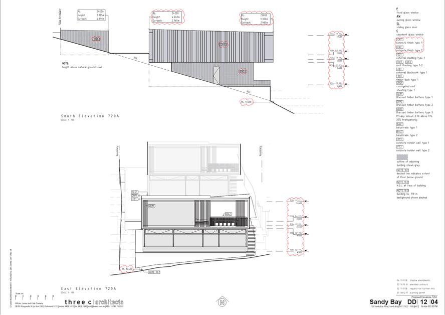
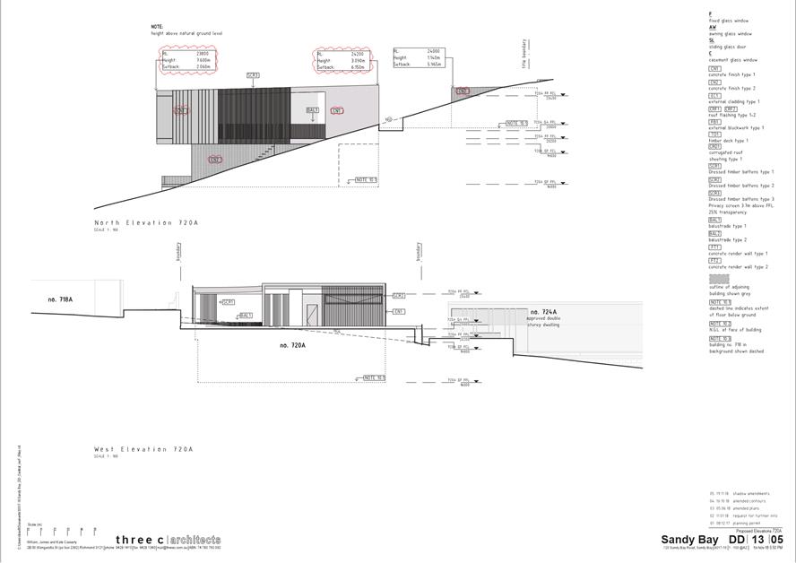
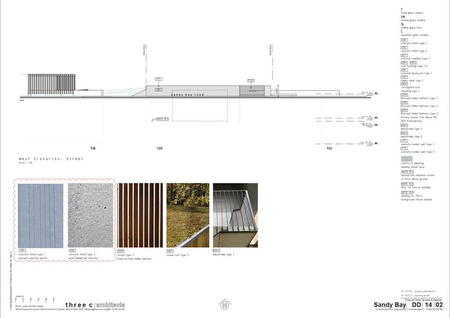
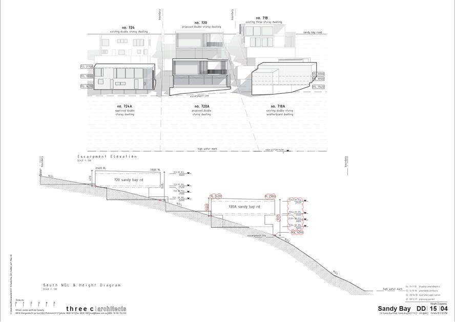
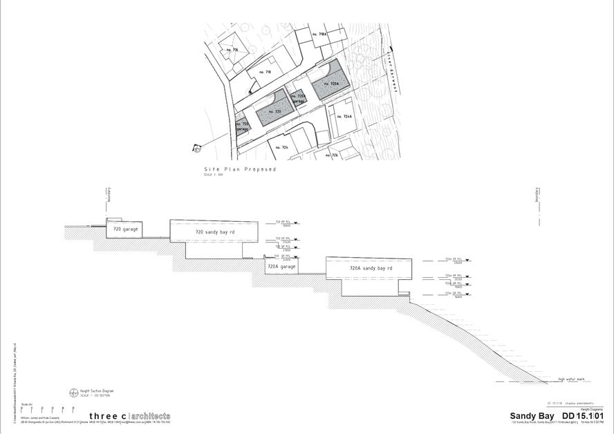
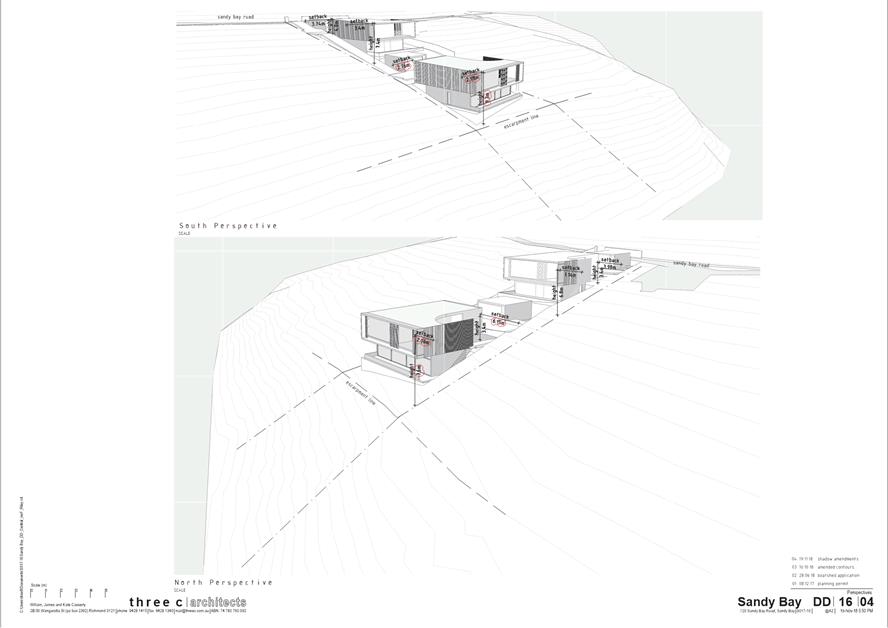
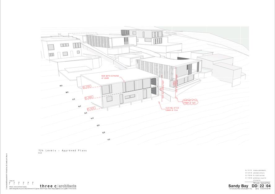
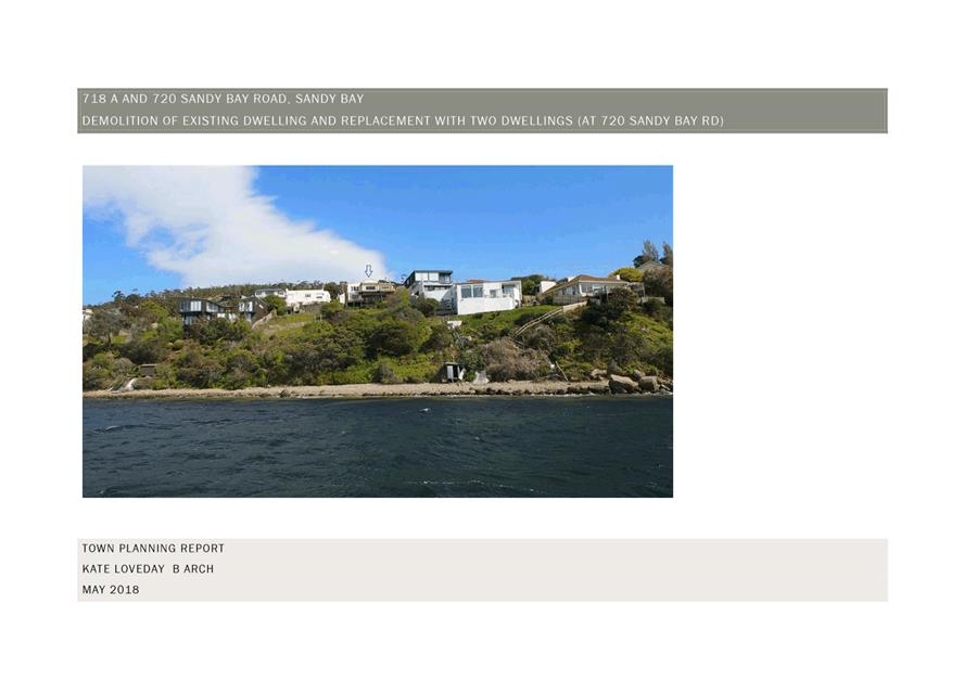
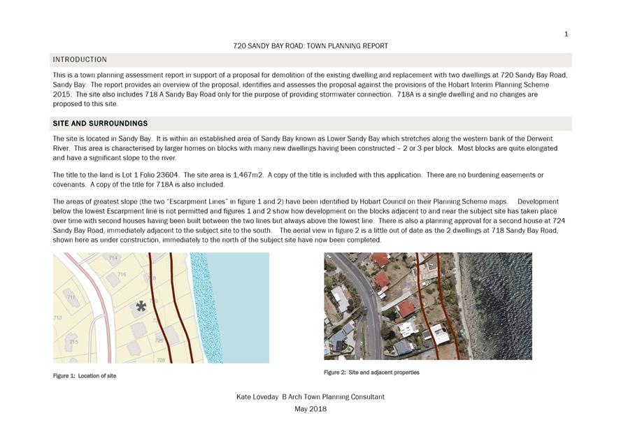
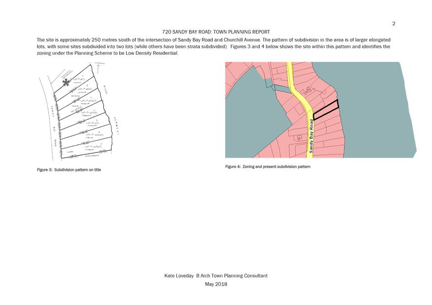
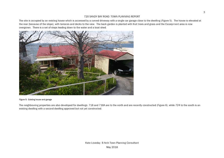
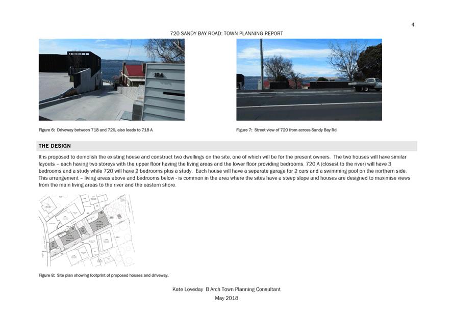
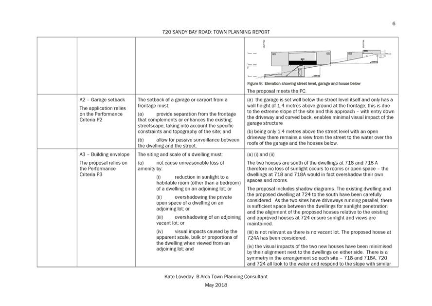
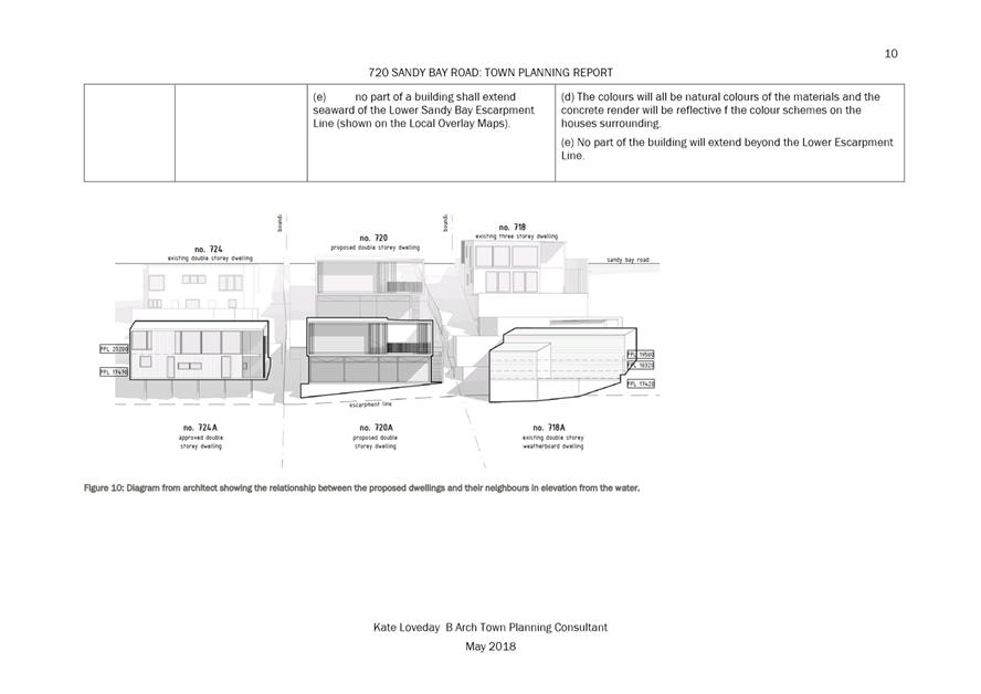
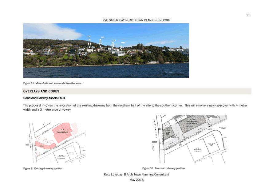
|
Item No. 7.2.4 |
Agenda (Open Portion) City Planning Committee Meeting - 24/6/2019 |
Page 387 ATTACHMENT b |

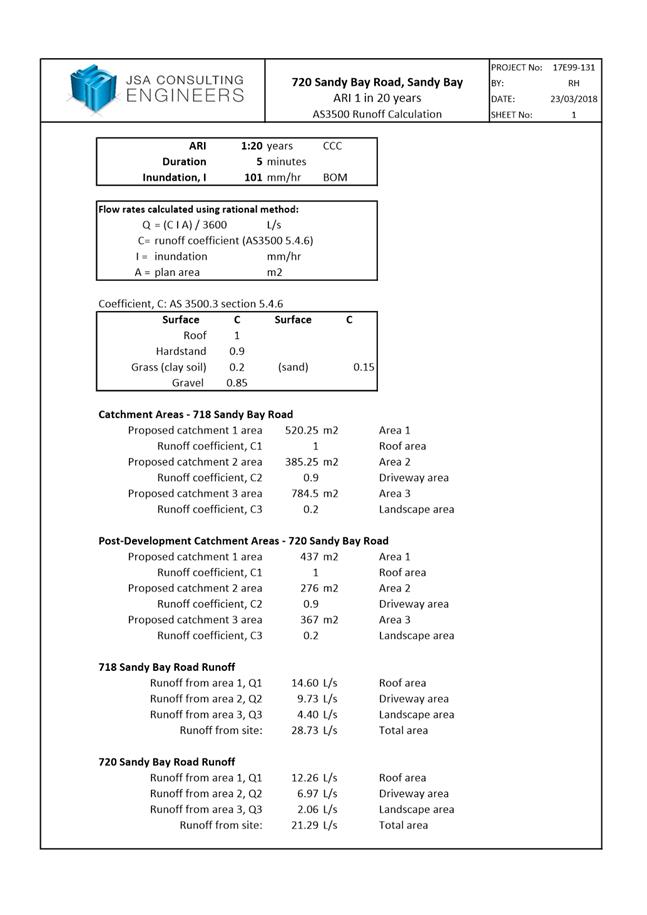
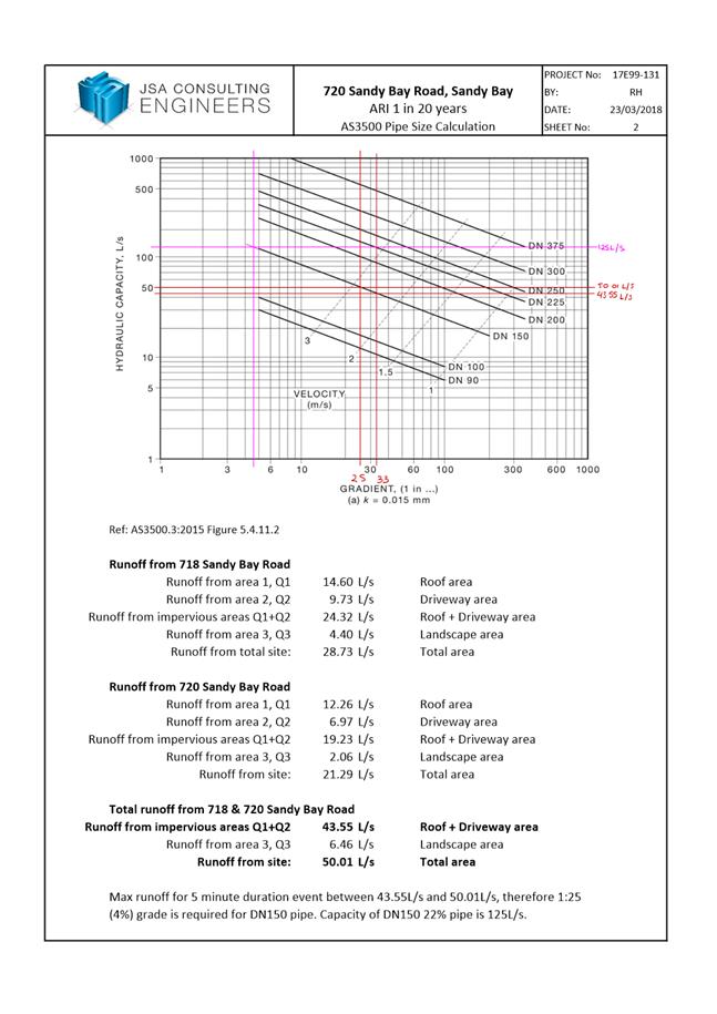
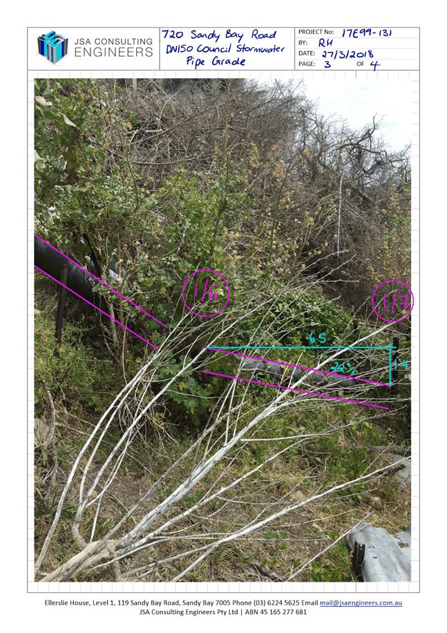
|
Item No. 7.2.4 |
Agenda (Open Portion) City Planning Committee Meeting - 24/6/2019 |
Page 394 ATTACHMENT b |
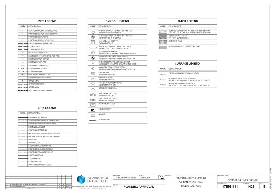
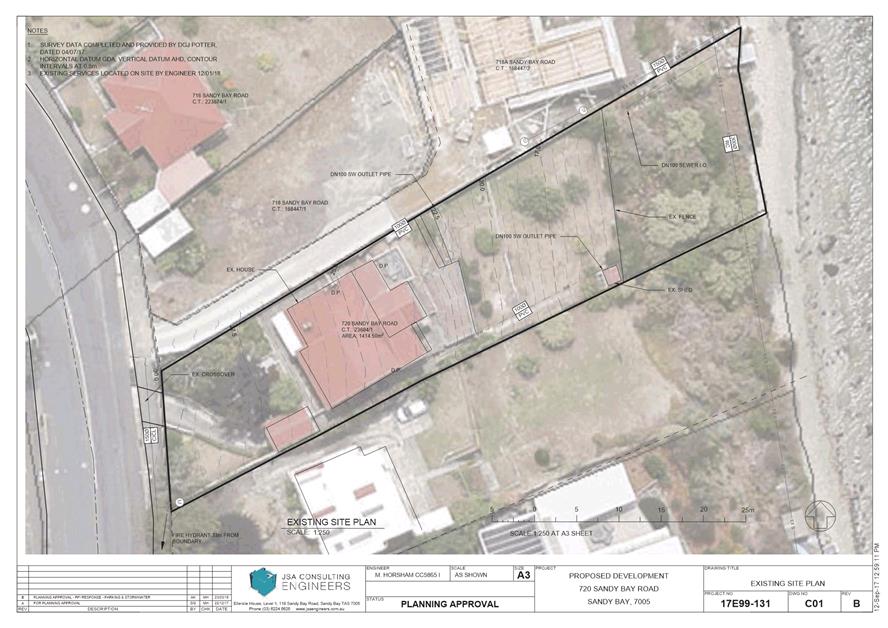
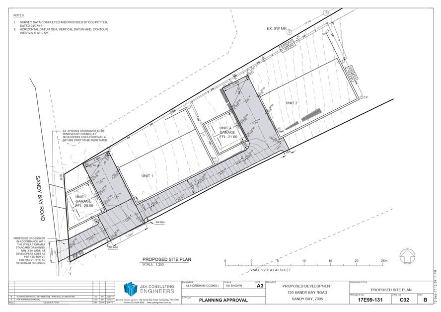
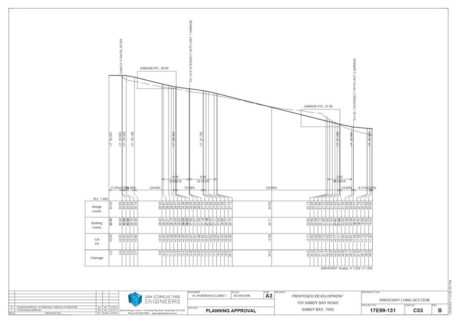
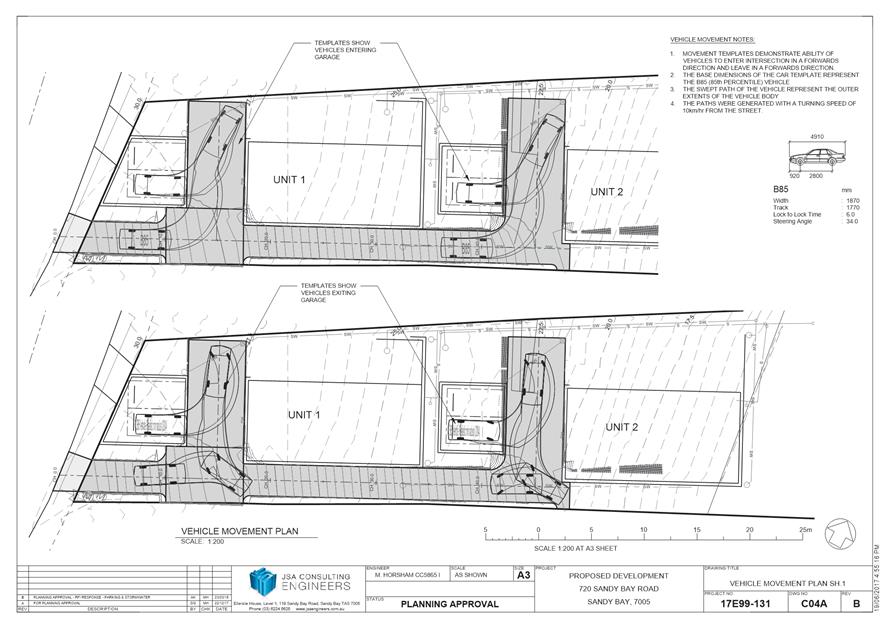
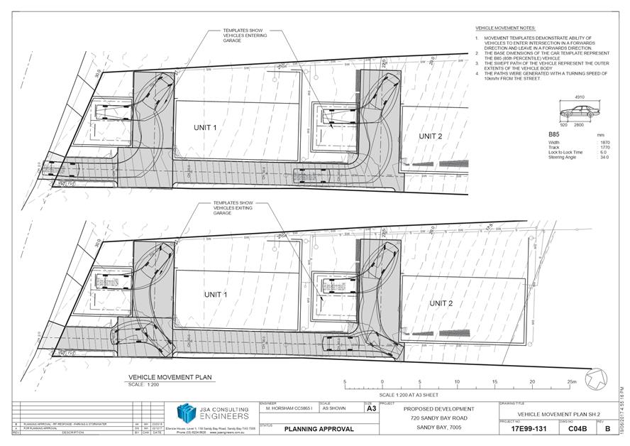
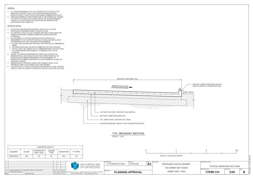
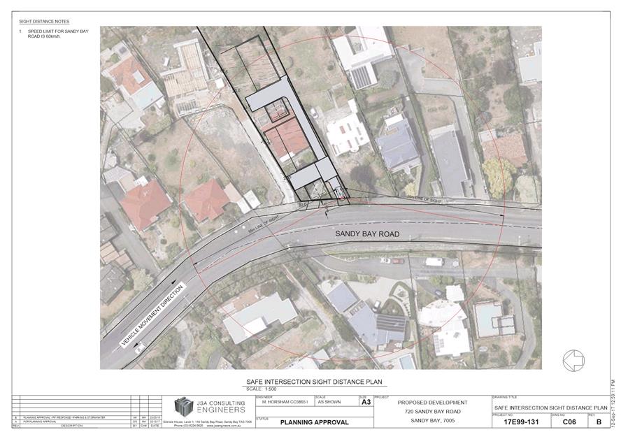
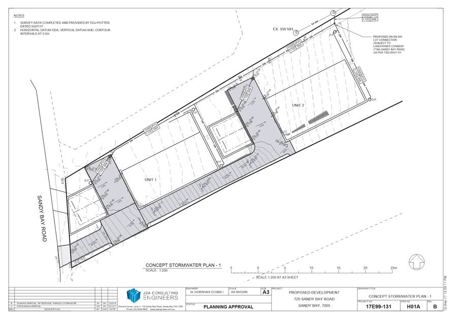
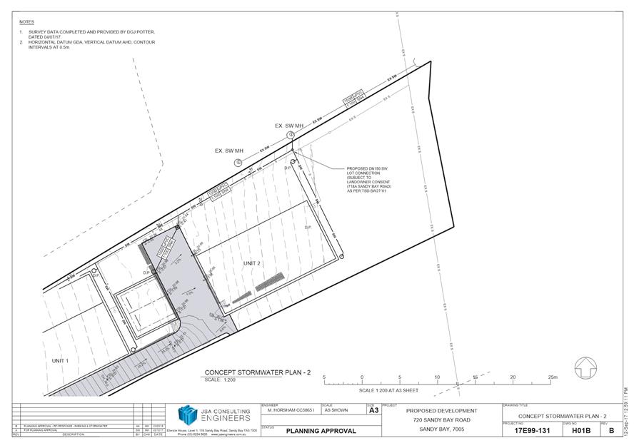
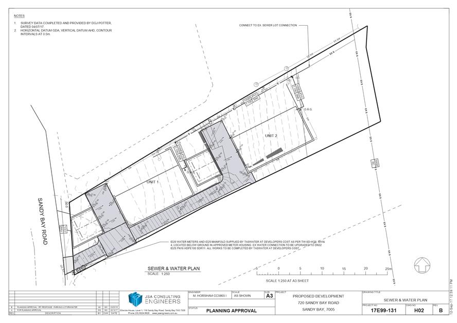
|
Item No. 7.2.4 |
Agenda (Open Portion) City Planning Committee Meeting - 24/6/2019 |
Page 409 ATTACHMENT b |
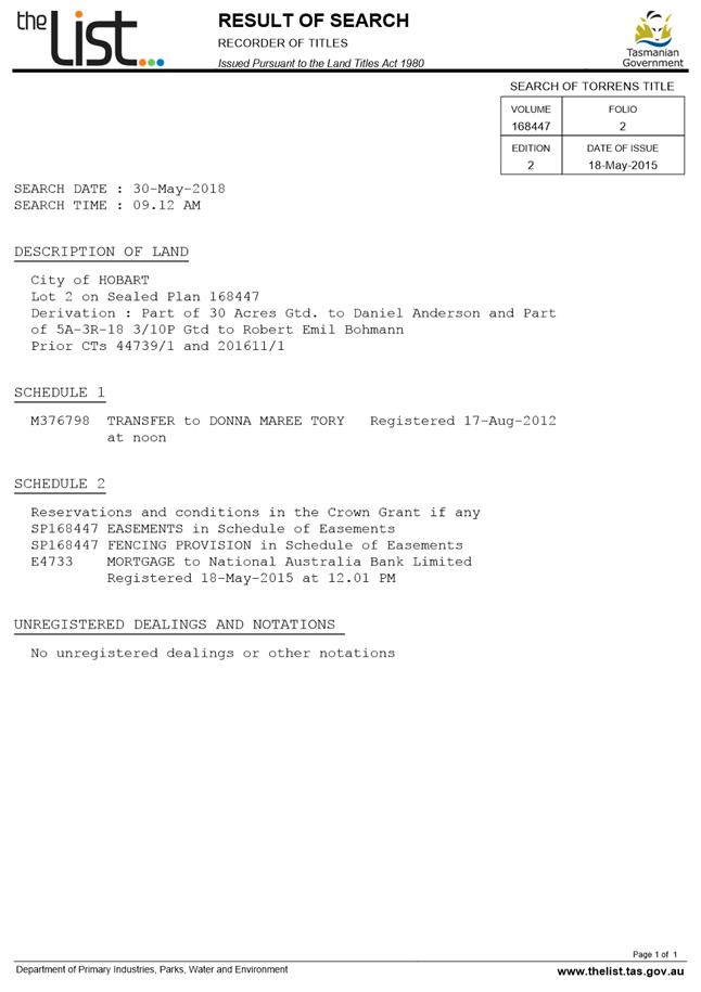
|
Item No. 7.2.4 |
Agenda (Open Portion) City Planning Committee Meeting - 24/6/2019 |
Page 416 ATTACHMENT b |
|
Item No. 7.2.4 |
Agenda (Open Portion) City Planning Committee Meeting - 24/6/2019 |
Page 419 ATTACHMENT b |
|
Item No. 7.2.4 |
Agenda (Open Portion) City Planning Committee Meeting - 24/6/2019 |
Page 421 ATTACHMENT c |
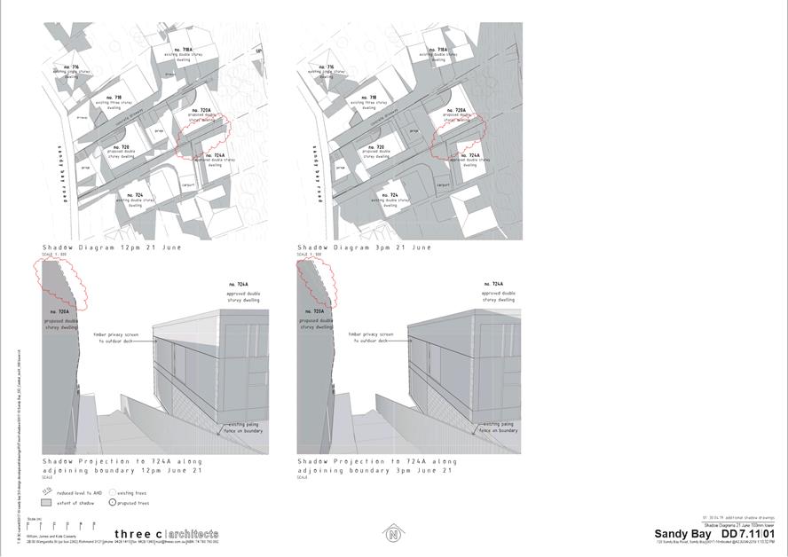
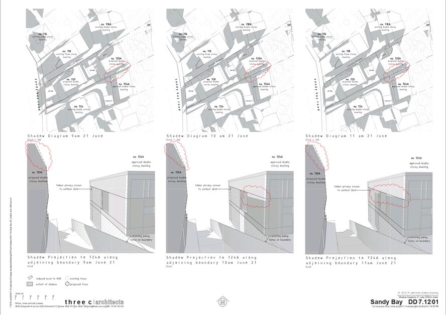
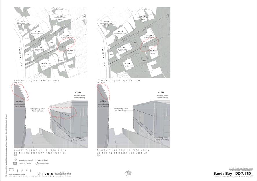
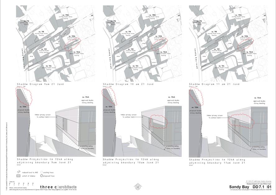
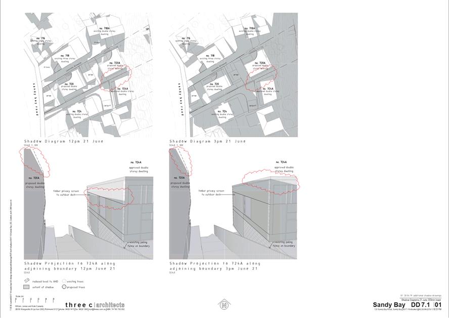
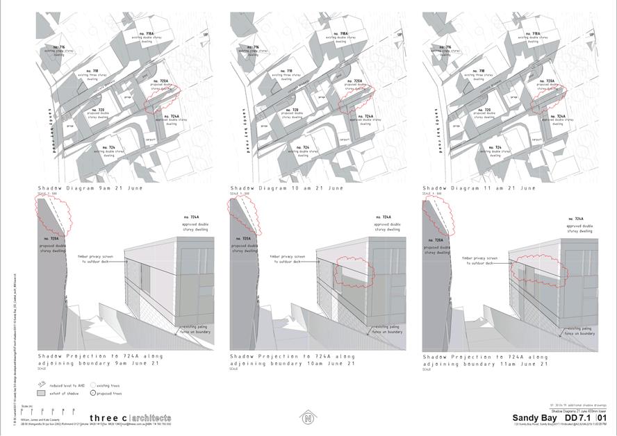
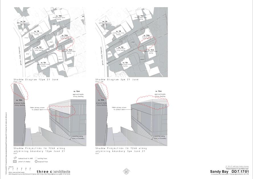
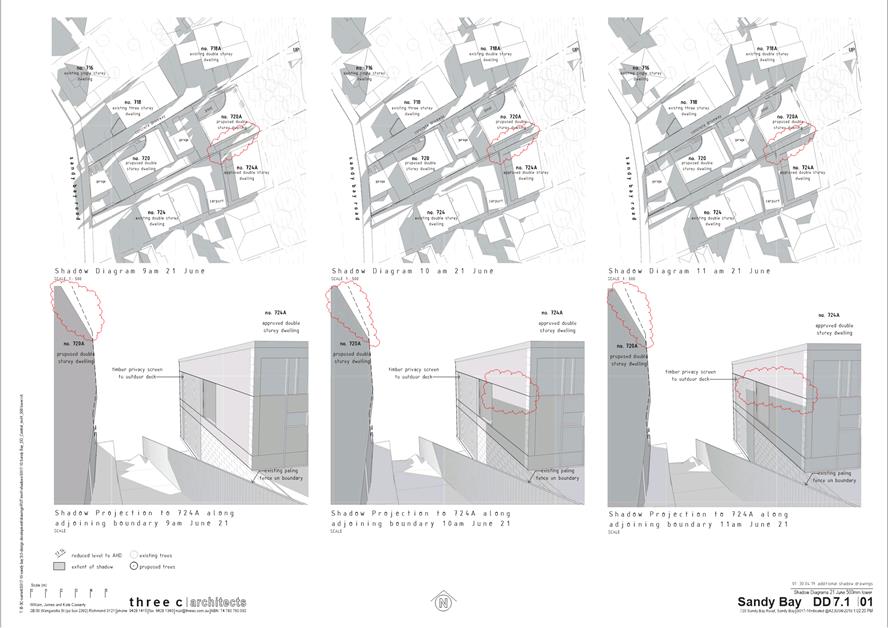

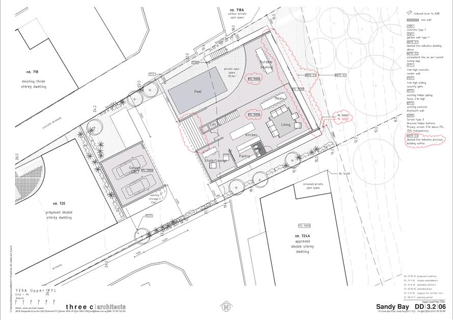
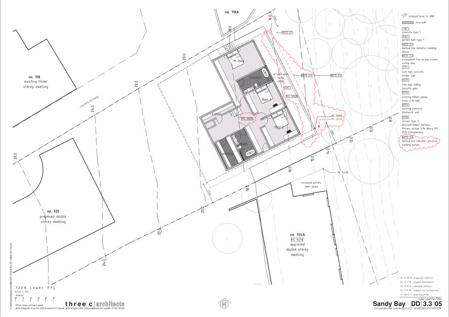
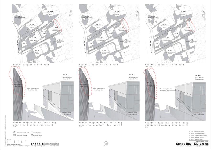
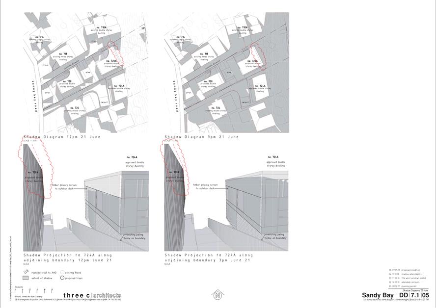
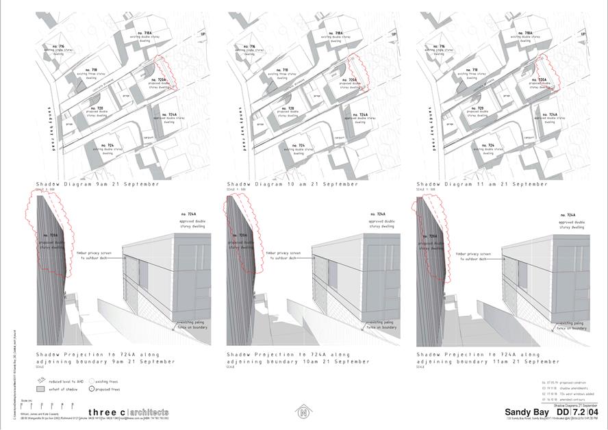
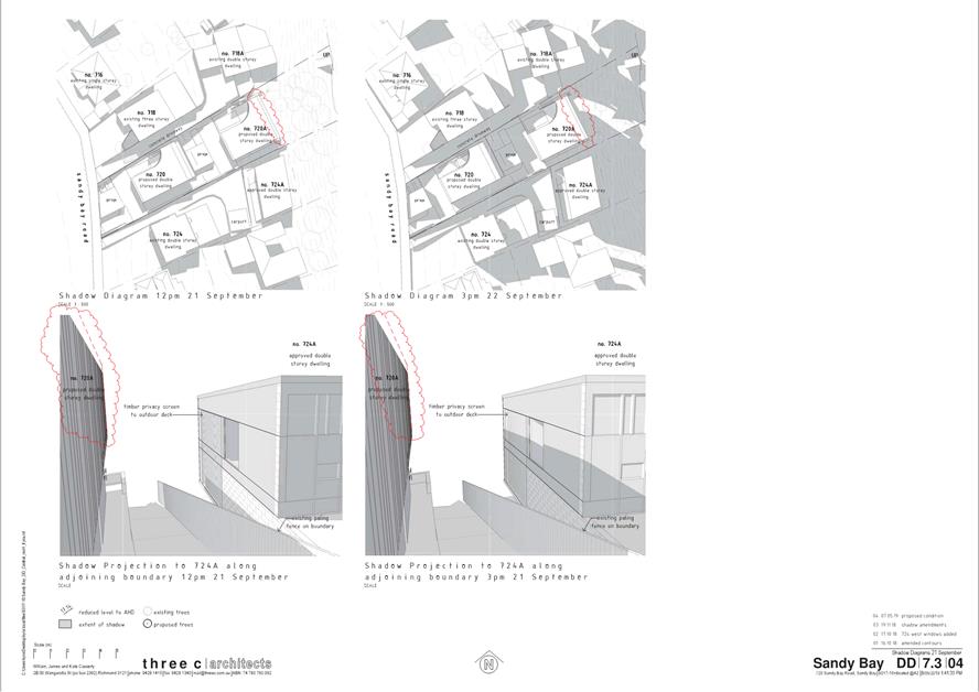
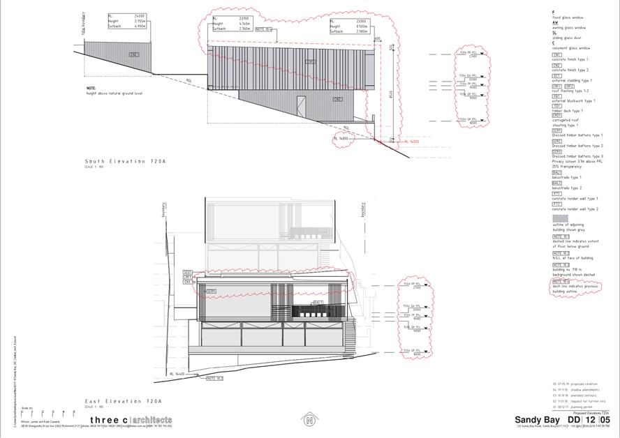
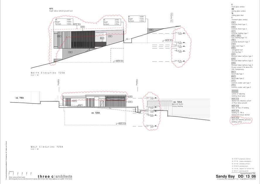
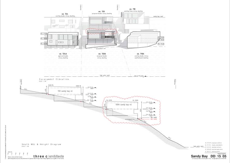
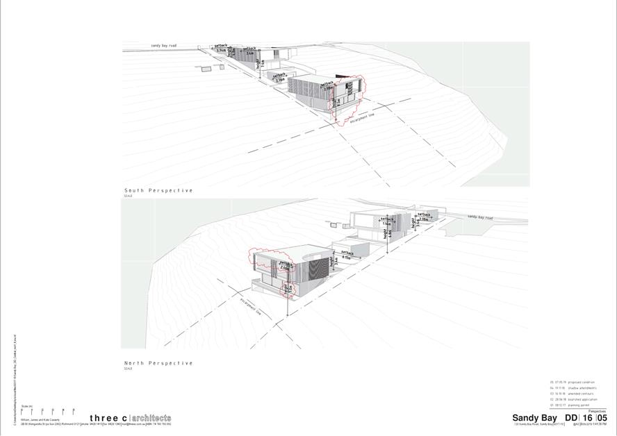
|
Agenda (Open Portion) City Planning Committee Meeting |
Page 441 |
|
|
|
24/6/2019 |
|
8 Reports
8.1 Central Hobart Precincts Plan - Project Brief
Report of the Manager Planning Policy & Heritage and Director City Planning of 19 June 2019 and attachment.
Delegation: Council
|
Item No. 8.1 |
Agenda (Open Portion) City Planning Committee Meeting |
Page 443 |
|
|
24/6/2019 |
|
REPORT TITLE: Central Hobart Precincts Plan - Project Brief
REPORT PROVIDED BY: Manager Planning Policy & Heritage
Director City Planning
1.1. The report seeks Councils endorsement of the project brief (Attachment A) for the proposed Central Hobart Precincts Plan Project.
1.2. The proposal benefits the community by helping to ensure that future development and public infrastructure provision and funding in Central Hobart is guided by an appropriate planning framework.
2. Report Summary
2.1. This report seeks Councils endorsement of the project brief (Attachment A) for the proposed Central Hobart Precincts Plan Project.
2.2. The scope of the Central Hobart Precincts Plan will include the following components:
2.2.1. Activities and land use - This section will articulate and develop the vision in terms of activities and land use for Central Hobart.
2.2.2. Urban Precincts and built form - This section will articulate and develop the vision in terms of the Precincts and built form in Central Hobart.
2.2.3. Movement and access - This section will articulate the vision relating to pedestrian, bicycle, vehicle, freight and public transport access in Central Hobart.
2.2.4. Public realm - This section will articulate and develop the vision in terms of open space and street design.
2.2.5. Community infrastructure and services - This section will articulate and develop the vision in terms of community facilities required in Central Hobart related to land use, built form and population and employment forecasts.
2.2.6. Implementation Plan - This section will set out immediate, short term and long term actions for Central Hobart. It will include an infrastructure staging plan and funding sources.
2.3. The Project Plan is outlined in Section 5 of the Brief and has a timeframe of 18 months.
2.4. The Project Plan proposes extensive community engagement as outlined in section 6 of the Project Brief. A more detailed Communication and Engagement Plan is to be developed prior to project commencement.
|
That Council endorse the Central Hobart Precincts Plan Project Brief provided as Attachment A to the report titled ‘Central Hobart Precincts Plan – Project Brief’ of 19 June 2019.
|
4. Background
4.1. The Minister for Planning, the Hon Roger Jaensch wrote to the Council on 4 March 2019 to offer a pathway forward on both the issue of building heights within Hobart and progressing the City Deal strategic approach to urban growth through the development of comprehensive precinct plans.
4.2. The Minister subsequently followed this offer up with a discussion with elected members on 8 April 2019, where he tabled an indicative scoping document developed between officers of the Council and the State Government.
4.3. At its meeting on 15 April 2019, the Council considered a report on the outcomes of the meeting with the Minister and the scope of work for the preparation of a Precincts Plan. Council agreed to work with the State Government to prepare a Terms of Reference and detailed work breakdown including a proposed allocation of tasks, funding and in-kind contribution for a Hobart Precincts Plan for the area of the city as outlined in Attachment B to item 3.1 of the Special Open City Planning Committee agenda of 15 April 2019.
4.4. At its meeting on 6 May 2019 Council reaffirmed its decision of 15 April 2019 that it will work with the State Government to develop a Central Hobart Precincts Plan (which will include a socio-economic and environmental study and use).
5. Proposal and Implementation
5.1. It is proposed that the Central Hobart Precincts Plan Project Brief provided in Attachment A be endorsed.
5.2. The Project Brief has been prepared in consultation with officers in the Department of State Growth and Department of Justice - Planning Policy Unit.
5.3. The objectives of the Central Hobart Precincts Plan project are to:
5.3.1. establish a shared vision and framework for the future growth, development and character of Central Hobart;
5.3.2. identify a suite of places or precincts across the study area based on locational advantages, key opportunity sites, or the relationships between character, built form, landscape, heritage and future use;
5.3.3. outline a vision for each precinct, which:
5.3.3.1. provides guidance for future development considering the need to provide for alternative housing options for the future population;
5.3.3.2. takes into account existing use and development patterns including existing constraints;
5.3.4. identify opportunities:
5.3.4.1. for a range of housing types and increased residential densities, and the implications for social and physical infrastructure, commercial and community services and facilities;
5.3.4.2. to increase accessibility and permeability of the area, access to public transport and provide support for sustainable travel behaviour;
5.3.5. support detailed precinct planning and potential synergies with other Hobart City Deal commitments;
5.3.6. identify the preferred urban form and scale of development for precincts based on a range of urban design, heritage, economic and social considerations;
5.3.7. ensure that community infrastructure, open space and transport provision meet the needs of a growing permanent and visitor population recognising the key role of the city centre in meeting transport and movement needs at a sub-regional and regional level;
5.3.8. ensure the ongoing viability of central Hobart as Tasmania’s key administrative and commercial activity centre with a concentration of the key business, retail, administrative, professional, community, cultural and event activities; and
5.3.9. identify a set of actions to deliver the vision and framework for the growth of Central Hobart, likely to include planning scheme amendments and capital works proposals.
5.4. Consistent with Hobart City Deal key focus areas, the precinct planning approach provides the most appropriate mechanism to address the complexity of planning, urban design, transport and movement, heritage, and the integration of these elements into a coherent set of planning, design and management objectives.
5.5. The scope of the Central Hobart Precincts Plan will include the following components:
5.5.1. Activities and land use - This section will articulate and develop the vision in terms of activities and land use for Central Hobart.
5.5.2. Urban Precincts and built form - This section will articulate and develop the vision in terms of the Precincts and built form in Central Hobart.
5.5.3. Movement and access - This section will articulate the vision relating to pedestrian, bicycle, vehicle, freight and public transport access in Central Hobart.
5.5.4. Public realm - This section will articulate and develop the vision in terms of open space and street design.
5.5.5. Community infrastructure and services - This section will articulate and develop the vision in terms of community facilities required in Central Hobart related to land use, built form and population and employment forecasts.
5.5.6. Implementation Plan - This section will set out immediate, short term and long term actions for Central Hobart. It will include an infrastructure staging plan and funding sources.
5.6. The Project Plan is outlined in Section 5 of the Brief and has a timeframe of 18 months.
6. Strategic Planning and Policy Considerations
6.1. The project will assist in the achievement of the strategic objectives of the Capital City Strategic Plan 2015-2025 particularly in relation to Goal 2 Urban Management - 2.3 "City and regional planning ensures quality design, meets community needs...."
6.2. The project is also relevant to the community aspirations for the future of Hobart as articulated in: Hobart: A community vision for our island capital, particularly in relation to the statements in:
6.2.1. Pillar 1. Sense of Place: We are a city of unique beauty, environment, heritage and people, built on a shared sense of ownership, pride and wonder.
6.2.2. Pillar 4. City Economies: We are a city whose economies connect people, businesses, education and government to create a high-quality lifestyle in a thriving and diverse community. Our city is our workshop. We collaborate, embracing ideas, inventiveness and initiative.
6.2.3. Pillar 5. Movement and Connectivity: We are a city where everyone has effective, safe, healthy and environmentally-friendly ways to move and connect, with people, information and goods, and to and through spaces and the natural environment. We are able to maintain a pace of life that allows us to fulfil our needs, such as work, study, business, socialising, recreation, accessing services, shopping, entertainment and spending time with loved ones.
6.2.4. Pillar 6. Natural Environment: We are a city whose people see ourselves as part of a beautiful and unique natural environment, from the mountain to the river, which embrace us and shape our identity. We are proud custodians and advocates, ensuring resources are appreciated rather than wasted, supporting biodiverse ecosystems in honour of past, current and future generations.
6.2.5. Pillar 7. Built Environment: We are a city that maintains our unique built and ecological character, where we all have a safe, secure and healthy place to live. We are a city where people and communities can access world-class services and infrastructure and provide for their social, cultural and economic wellbeing. We embrace change but not at the expense of our Hobart identity and character.
7. Financial Implications
7.1. Funding Source and Impact on Current Year Operating Result
7.1.1. The proposed budget for the project is $250,000. An appropriate budget allocation has been made for the 2019-20 financial year. The State Government has committed to providing half the funding for the project.
7.2. Impact on Future Years’ Financial Result
7.2.1. A further budget allocation can be considered in the 2020/2021 financial year if necessary.
7.3. Asset Related Implications
7.3.1. This will be addressed in the implementation plan phase.
8. Legal, Risk and Legislative Considerations
8.1. None at this stage of the process.
9. Community and Stakeholder Engagement
9.1. The community engagement approach will involve three stages, as outlined in section 6 of the Project Brief. A more detailed Communication and Engagement Plan is to be developed prior to project commencement.
10. Delegation
10.1. This matter is delegated to the Council.
As signatory to this report, I certify that, pursuant to Section 55(1) of the Local Government Act 1993, I hold no interest, as referred to in Section 49 of the Local Government Act 1993, in matters contained in this report.
|
James McIlhenny Manager Planning Policy & Heritage |
Neil Noye Director City Planning |
Date: 19 June 2019
File Reference: F19/77737; 17/167
Attachment a: Central
Hobart Precincts Plan Project Brief ⇩ ![]()
|
Item No. 8.1 |
Agenda (Open Portion) City Planning Committee Meeting - 24/6/2019 |
Page 449 ATTACHMENT a |

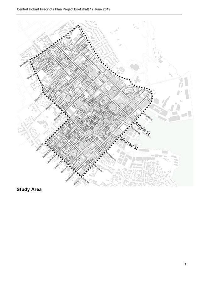
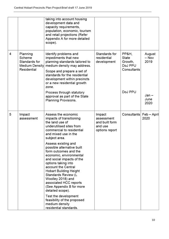
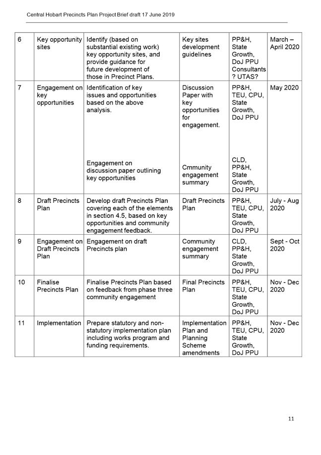
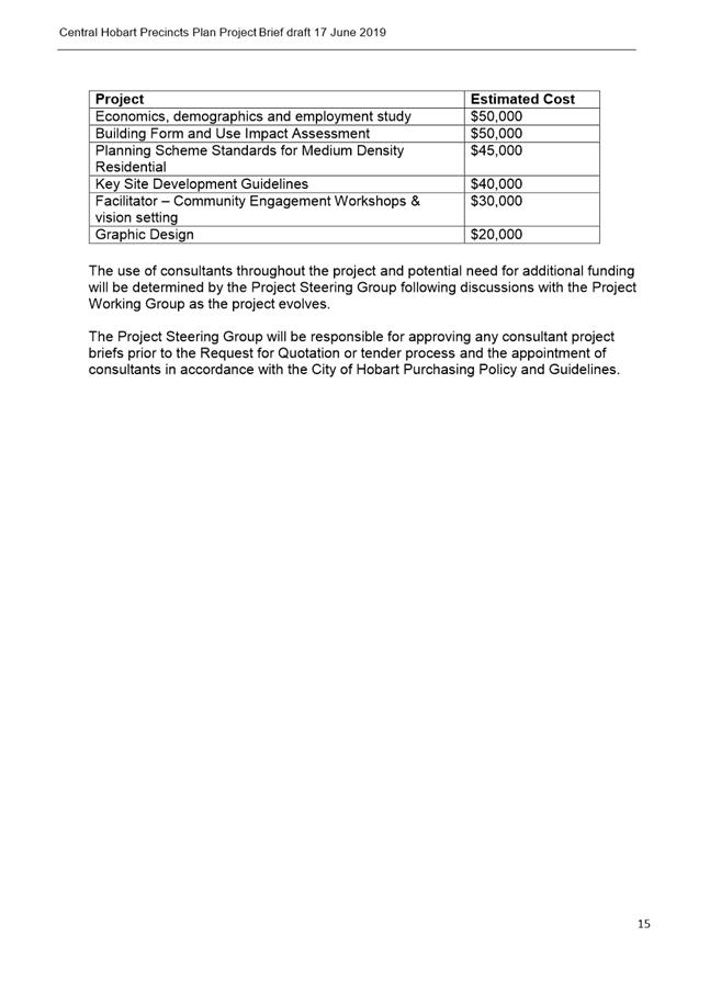

|
Agenda (Open Portion) City Planning Committee Meeting |
Page 470 |
|
|
|
24/6/2019 |
|
8.2 Civic Precinct Master Plan Proposal - Response from Minister
Memorandum of the Manager Planning Policy & Heritage and Director City Planning of 19 June 2019 and attachments.
Delegation: Council
|
Item No. 8.2 |
Agenda (Open Portion) City Planning Committee Meeting |
Page 472 |
|
|
24/6/2019 |
|

Memorandum: City Planning Committee
Civic Precinct Master Plan Proposal - Response from Minister
At the Council meeting held 6 August 2018, the Council (Open Council) resolved that:
The State Government be invited to participate in and jointly fund the formulation of a Master Plan for the area bounded by Murray, Macquarie, Campbell and Davey Streets (Civic Precinct).
When making the invitation the Minister for Local Government, the Hon Peter Gutwein MP, was advised by the Director City Planning as follows:
As you are aware, the area bounded by Murray, Macquarie, Campbell and Davey Streets contains many of Hobart's finest civic buildings and public spaces. The buildings are all heritage-listed and have Conservation Plans and other management documents. The precinct also accommodates part of Hobart's central public transport hub. The Council considers that there is some merit in adopting a co-ordinated approach to the future use and development of the historic precinct. Such an approach could feed into planning scheme controls.
A Master Plan could draw together the various previous studies (including Conservation Plans) and include a comprehensive urban design analysis. The benefit of a co-ordinated Master Plan would be an integrated identification of opportunities within the precinct. The Master Plan would also identify site-specific use and development controls.
The initial response from the Minister was to request further information and the response to that request from the Lord Mayor is provided in Attachment A.
The Council has now received a response from the Minister (Attachment B). The Minister has declined the Council’s invitation. To summarise the Minister’s response, he notes that there are already a number of mechanisms available under the Tasmanian Planning System to achieve the desired outcomes of a civic precinct master plan. The Minister advises, for example, that there is capacity to introduce specific controls as part of the Council's Local Provisions Schedule within the Tasmanian Planning Scheme, or creation of a Particular Purposes Zone (PPZ) or Specific Area Plan (SAP) within the Sullivans Cove Planning Scheme 1997.
The State Government has a key role in future planning of the area, as it owns the Franklin Square Offices and the Tasmanian Museum and Art Gallery sites within the nominated area. While the Council could pursue the development of specific planning mechanisms of its own volition, the involvement of the State Government would have been regarded as critical to a meaningful outcome.
It should be noted that a budget allocation has not been made for the preparation of a master plan for the Civic Precinct in the 2019-20 financial year.
|
That: 1. That the information contained in the report title Civic Precinct Master Plan Proposal - Response from Minister’ of 19 June 2019 be received and noted. 2. The matter be considered by Council.
|
As signatory to this report, I certify that, pursuant to Section 55(1) of the Local Government Act 1993, I hold no interest, as referred to in Section 49 of the Local Government Act 1993, in matters contained in this report.
|
James McIlhenny Manager Planning Policy & Heritage |
Neil Noye Director City Planning |
Date: 19 June 2019
File Reference: F19/78434; 17/167
Attachment a: Response
to Further Information Request ⇩ ![]()
Attachment
b: Response
from Minister Gutwein ⇩ ![]()
|
Item No. 8.2 |
Agenda (Open Portion) City Planning Committee Meeting - 24/6/2019 |
Page 474 ATTACHMENT a |
|
Agenda (Open Portion) City Planning Committee Meeting - 24/6/2019 |
Page 476 ATTACHMENT b |

|
Agenda (Open Portion) City Planning Committee Meeting |
Page 477 |
|
|
|
24/6/2019 |
|
8.3 City Planning - Advertising Report
Memorandum of the Director City Planning of 19 June 2019 and attachment.
Delegation: Committee
|
Item No. 8.3 |
Agenda (Open Portion) City Planning Committee Meeting |
Page 478 |
|
|
24/6/2019 |
|

Memorandum: City Planning Committee
City Planning - Advertising Report
Attached is the advertising list for the period 3 June 2019 – 14 June 2019.
|
That the information contained in the memorandum titled ‘City Planning - Advertising Report’ 19 June 2019 be received and noted.
|
As signatory to this report, I certify that, pursuant to Section 55(1) of the Local Government Act 1993, I hold no interest, as referred to in Section 49 of the Local Government Act 1993, in matters contained in this report.
|
Neil Noye Director City Planning |
|
Date: 19 June 2019
File Reference: F19/78655
Attachment a: City
Planning - Advertising Report ⇩ ![]()
|
Item No. 8.3 |
Agenda (Open Portion) City Planning Committee Meeting - 24/6/2019 |
Page 480 ATTACHMENT a |
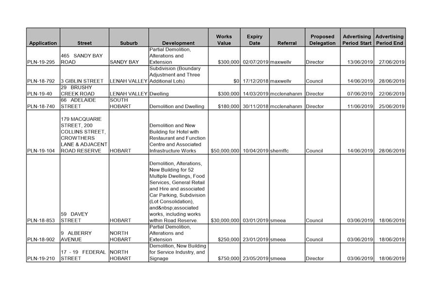
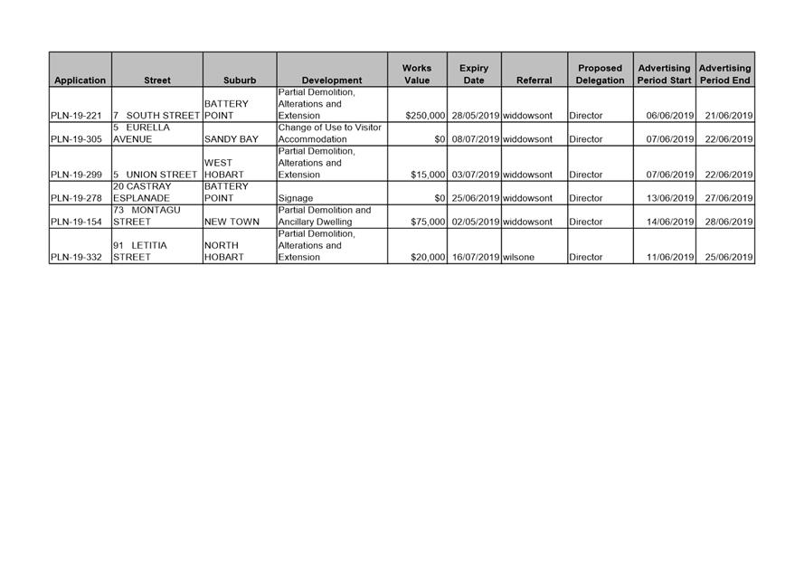
|
Agenda (Open Portion) City Planning Committee Meeting |
Page 483 |
|
|
|
24/6/2019 |
|
8.4 Delegated Decisions Report (Planning)
Memoradum of the Director City Planning of 19 June 2019 and attachment.
Delegation: Committee
|
Item No. 8.4 |
Agenda (Open Portion) City Planning Committee Meeting |
Page 484 |
|
|
24/6/2019 |
|
Memorandum: City Planning Committee
Delegated Decisions Report (Planning)
Attached is the Delegated Planning Decision Report for the period 3 June 2019 until 17 June 2019.
|
That the information contained in the memorandum titled ‘Delegated Decisions Report (Planning)’ of 19 June 2019 be received and noted.
|
As signatory to this report, I certify that, pursuant to Section 55(1) of the Local Government Act 1993, I hold no interest, as referred to in Section 49 of the Local Government Act 1993, in matters contained in this report.
|
Neil Noye Director City Planning |
|
Date: 19 June 2019
File Reference: F19/78756
Attachment a: Delegated
Decisions Report (Planning) ⇩ ![]()
|
Item No. 8.4 |
Agenda (Open Portion) City Planning Committee Meeting - 24/6/2019 |
Page 486 ATTACHMENT a |
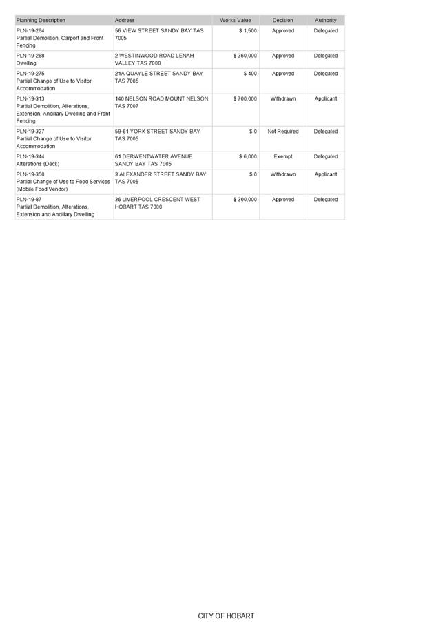
|
Agenda (Open Portion) City Planning Committee Meeting |
Page 487 |
|
|
|
24/6/2019 |
|
9 Committee Action Status Report
A report indicating the status of current decisions is attached for the information of Elected Members.
REcommendation
That the information be received and noted.
Delegation: Committee
|
Item No. 9.1 |
Agenda (Open Portion) City Planning Committee Meeting - 24/6/2019 |
Page 489 ATTACHMENT a |
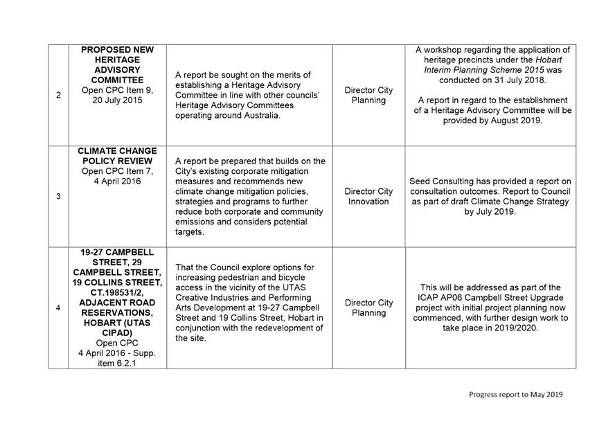
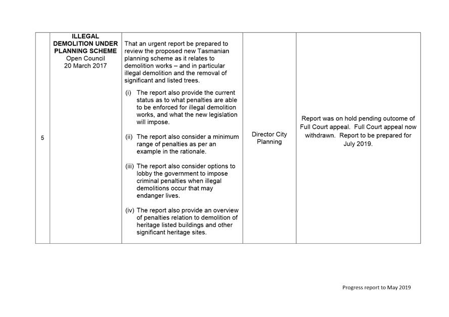
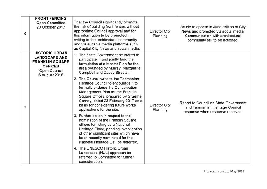
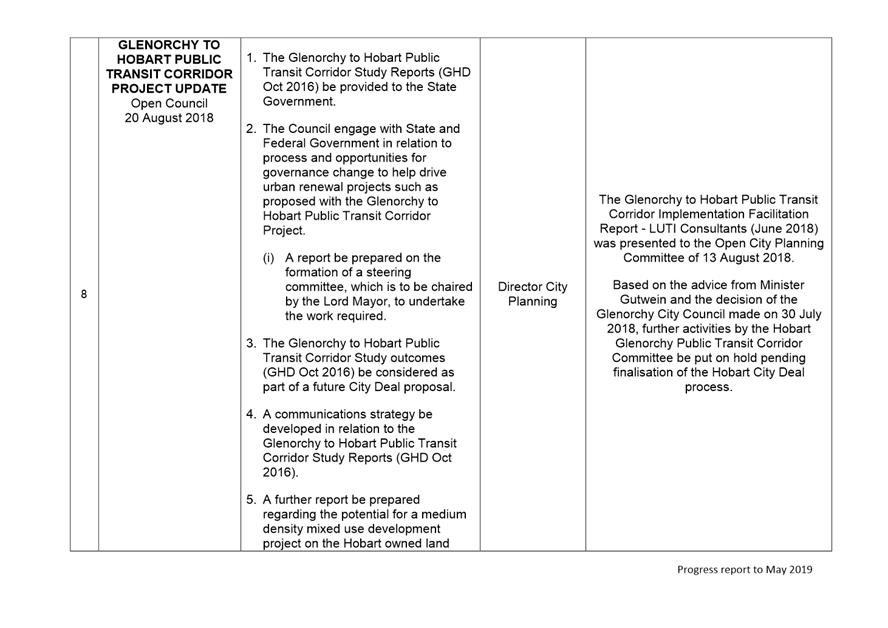
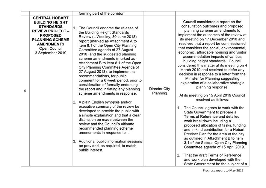

|
|
Agenda (Open Portion) City Planning Committee Meeting |
Page 502 |
|
|
24/6/2019 |
|
Section 29 of the Local Government (Meeting Procedures) Regulations 2015.
File Ref: 13-1-10
An Elected Member may ask a question without notice of the Chairman, another Elected Member, the General Manager or the General Manager’s representative, in line with the following procedures:
1. The Chairman will refuse to accept a question without notice if it does not relate to the Terms of Reference of the Council committee at which it is asked.
2. In putting a question without notice, an Elected Member must not:
(i) offer an argument or opinion; or
(ii) draw any inferences or make any imputations – except so far as may be necessary to explain the question.
3. The Chairman must not permit any debate of a question without notice or its answer.
4. The Chairman, Elected Member, General Manager or General Manager’s representative who is asked a question may decline to answer the question, if in the opinion of the respondent it is considered inappropriate due to its being unclear, insulting or improper.
5. The Chairman may require a question to be put in writing.
6. Where a question without notice is asked and answered at a meeting, both the question and the response will be recorded in the minutes of that meeting.
7. Where a response is not able to be provided at the meeting, the question will be taken on notice and
(i) the minutes of the meeting at which the question is asked will record the question and the fact that it has been taken on notice.
(ii) a written response will be provided to all Elected Members, at the appropriate time.
(iii) upon the answer to the question being circulated to Elected Members, both the question and the answer will be listed on the agenda for the next available ordinary meeting of the committee at which it was asked, where it will be listed for noting purposes only.
|
|
Agenda (Open Portion) City Planning Committee Meeting |
Page 503 |
|
|
24/6/2019 |
|