City
of hobart
AGENDA
City Planning Committee Meeting
Open Portion
Monday, 21 March 2022
at 5:00 pm
Council Chamber, Town Hall
City
of hobart
AGENDA
City Planning Committee Meeting
Open Portion
Monday, 21 March 2022
at 5:00 pm
Council Chamber, Town Hall
Working together to make Hobart a better place for the community.
THE VALUES
The Council is:
|
People |
We care about people – our community, our customers and colleagues. |
|
Teamwork |
We collaborate both within the organisation and with external stakeholders drawing on skills and expertise for the benefit of our community. |
|
Focus and Direction |
We have clear goals and plans to achieve sustainable social, environmental and economic outcomes for the Hobart community. |
|
Creativity and Innovation |
We embrace new approaches and continuously improve to achieve better outcomes for our community. |
|
Accountability |
We are transparent, work to high ethical and professional standards and are accountable for delivering outcomes for our community. |
|
|
Agenda (Open Portion) City Planning Committee Meeting |
Page 3 |
|
|
21/3/2022 |
|
Business listed on the agenda is to be conducted in the order in which it is set out, unless the committee by simple majority determines otherwise.
APOLOGIES AND LEAVE OF ABSENCE
1. Co-Option of a Committee Member in the event of a vacancy
3. Consideration of Supplementary Items
4. Indications of Pecuniary and Conflicts of Interest
6. Planning Authority Items - Consideration of Items With Deputations
7. Committee Acting as Planning Authority
7.1 Applications under the Hobart Interim Planning Scheme 2015
7.1.1 720 Sandy Bay Road, Sandy Bay - Alterations (Chimneys)
7.1.4 Short Stay Accommodation - Proposed Amendments to the Hobart Interim Planning Scheme
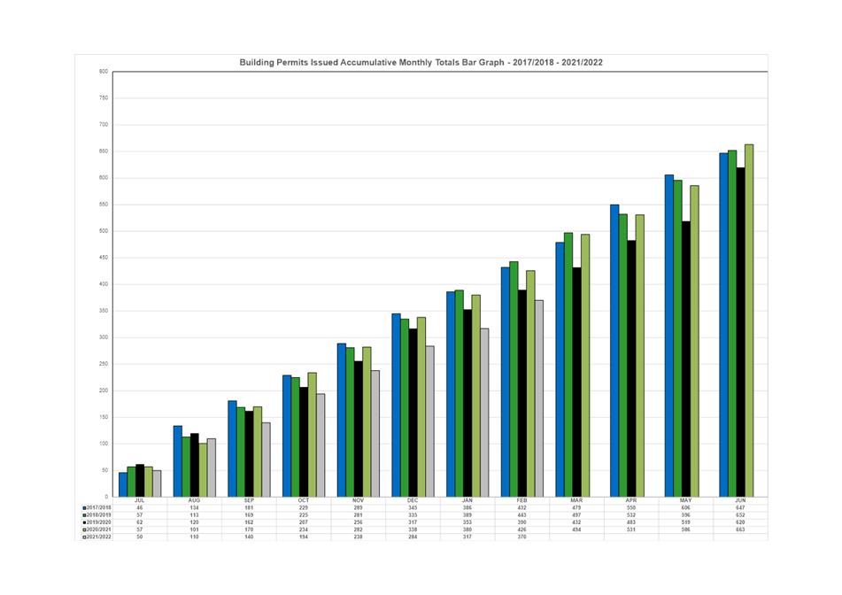
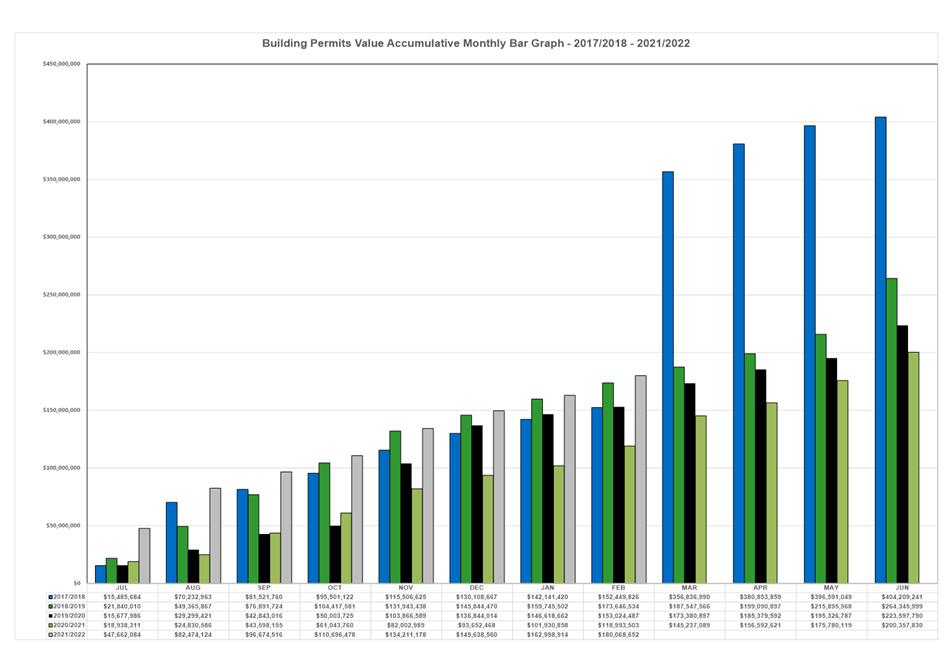
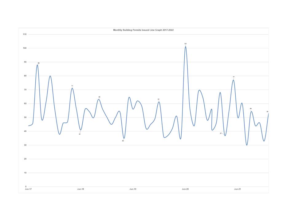
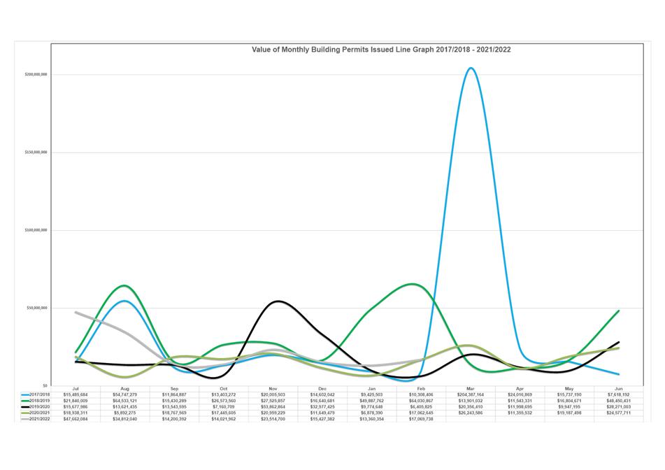
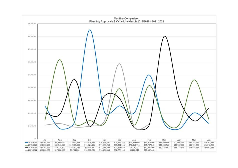
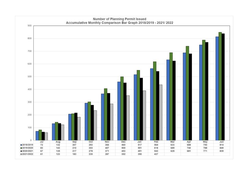
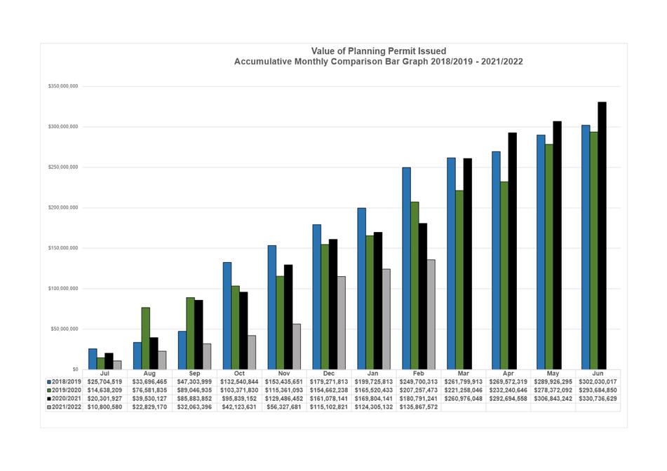
8.1 Monthly Building Statistics - 1 February - 28 February 2022
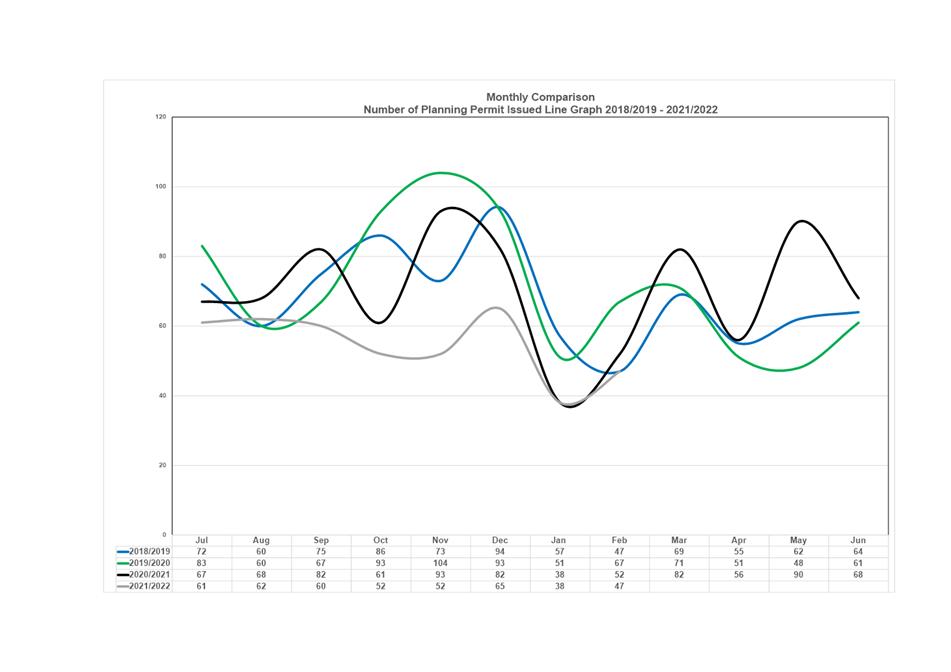
8.2 Monthly Planning Statistics - 1 February - 28 February 2022
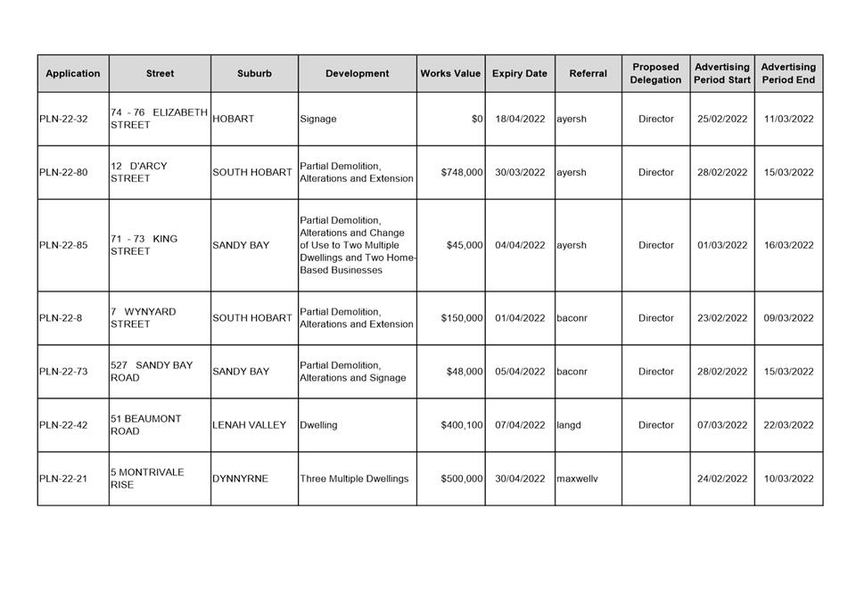
8.3 City Planning - Advertising Report
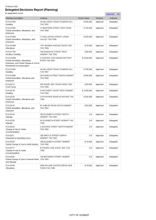
8.4 Delegated Decision Report (Planning)
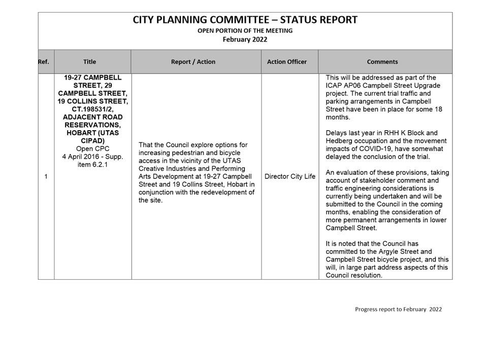
9. Committee Action Status Report
9.1 Committee Actions - Status Report
11. Closed Portion Of The Meeting
|
|
Agenda (Open Portion) City Planning Committee Meeting |
Page 5 |
|
|
21/3/2022 |
|
City Planning Committee Meeting (Open Portion) held Monday, 21 March 2022 at 5:00 pm in the Council Chamber, Town Hall.
This meeting of the City Planning Committee is held in accordance with a
Notice issued by the Premier on 3 April 2020 under section 18 of the COVID-19
Disease Emergency (Miscellaneous Provisions) Act 2020.
The title Chief Executive Officer is a term of reference for the General Manager as appointed by Council pursuant s.61 of the Local Government Act 1993 (Tas).
|
COMMITTEE MEMBERS Deputy Lord Mayor Burnet (Chairman) Alderman J Briscoe Councillor W F Harvey Alderman S Behrakis Councillor M Dutta Councillor W Coats
NON-MEMBERS Lord Mayor Councillor A M Reynolds Alderman M Zucco Alderman Dr P T Sexton Alderman D C Thomas Councillor J Fox Councillor Dr Z Sherlock |
Apologies:
Leave of Absence: Nil.
|
|
The minutes of the Open Portion of the City Planning Committee meeting held on Monday, 7 March 2022, are submitted for confirming as an accurate record.
|
Ref: Part 2, Regulation 8(6) of the Local Government (Meeting Procedures) Regulations 2015.
|
That the Committee resolve to deal with any supplementary items not appearing on the agenda, as reported by the Chief Executive Officer.
|
Ref: Part 2, Regulation 8(7) of the Local Government (Meeting Procedures) Regulations 2015.
Members of the Committee are requested to indicate where they may have any pecuniary or conflict of interest in respect to any matter appearing on the agenda, or any supplementary item to the agenda, which the Committee has resolved to deal with.
Regulation 15 of the Local Government (Meeting Procedures) Regulations 2015.
A Committee may close a part of a meeting to the public where a matter to be discussed falls within 15(2) of the above regulations.
In the event that the Committee transfer an item to the closed portion, the reasons for doing so should be stated.
Are there any items which should be transferred from this agenda to the closed portion of the agenda, or from the closed to the open portion of the agenda?
In accordance with the requirements of Part 2 Regulation 8(3) of the Local Government (Meeting Procedures) Regulations 2015, the Chief Executive Officer is to arrange the agenda so that the planning authority items are sequential.
In accordance with Part 2 Regulation 8(4) of the Local Government (Meeting Procedures) Regulations 2015, the Committee by simple majority may change the order of any of the items listed on the agenda, but in the case of planning items they must still be considered sequentially – in other words they still have to be dealt with as a single group on the agenda.
Where deputations are to be received in respect to planning items, past practice has been to move consideration of these items to the beginning of the meeting.
RECOMMENDATION
That in accordance with Regulation 8(4) of the Local Government (Meeting Procedures) Regulations 2015, the Committee resolve to deal with any items which have deputations by members of the public regarding any planning matter listed on the agenda, to be taken out of sequence in order to deal with deputations at the beginning of the meeting.
|
|
Agenda (Open Portion) City Planning Committee Meeting |
Page 7 |
|
|
21/3/2022 |
|
In accordance with the provisions of Part 2 Regulation 25 of the Local Government (Meeting Procedures) Regulations 2015, the intention of the Committee to act as a planning authority pursuant to the Land Use Planning and Approvals Act 1993 is to be noted.
In accordance with Regulation 25, the Committee will act as a planning authority in respect to those matters appearing under this heading on the agenda, inclusive of any supplementary items.
The Committee is reminded that in order to comply with Regulation 25(2), the Chief Executive Officer is to ensure that the reasons for a decision by a Council or Council Committee acting as a planning authority are recorded in the minutes.
|
Agenda (Open Portion) City Planning Committee Meeting |
Page 9 |
|
|
|
21/3/2022 |
|
7.1 Applications under the Hobart Interim Planning Scheme 2015
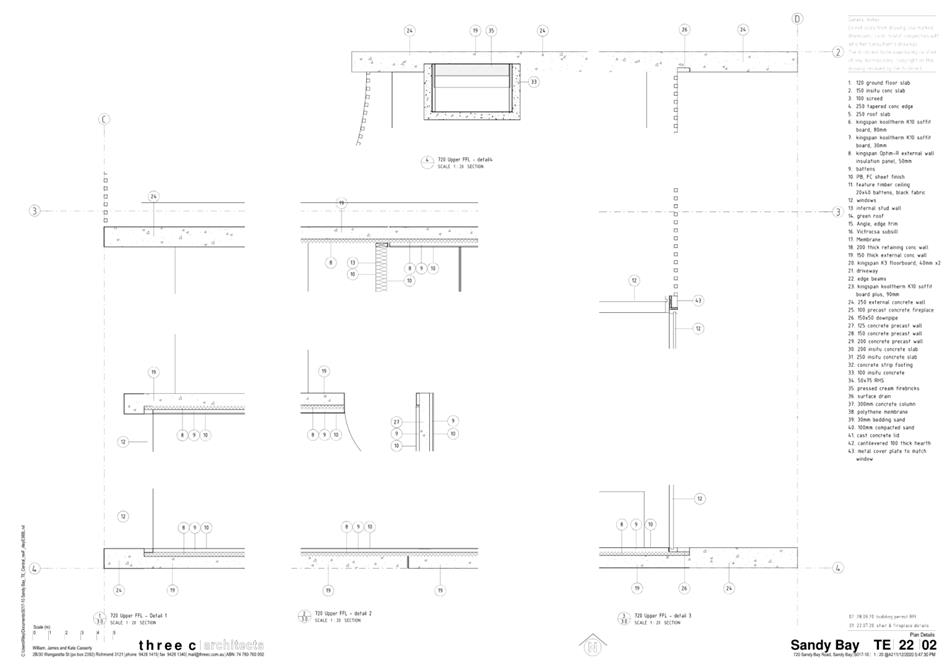
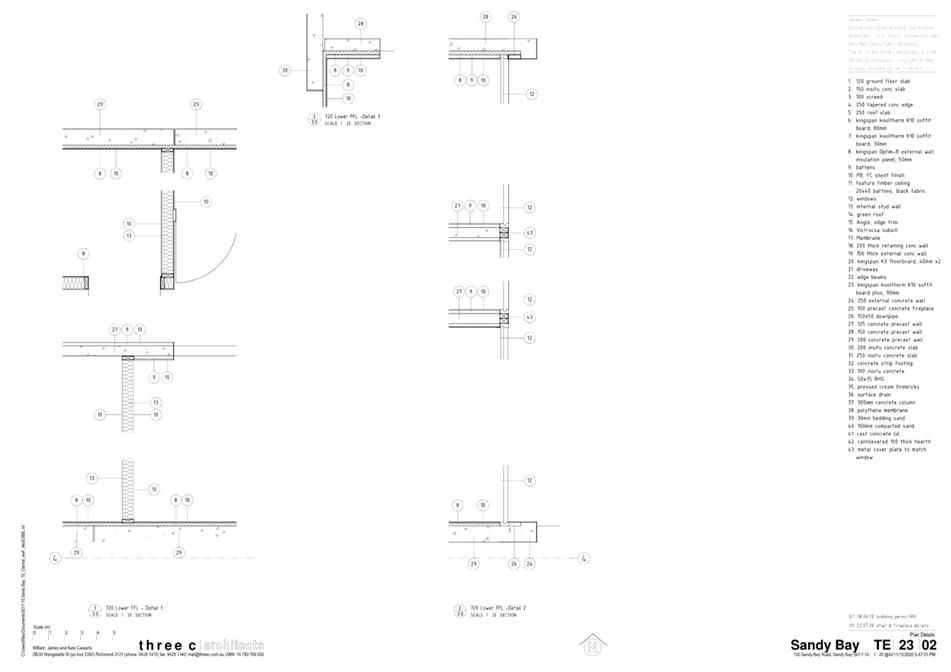
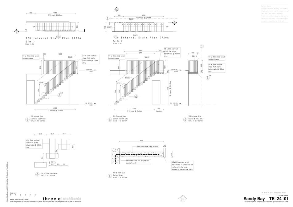
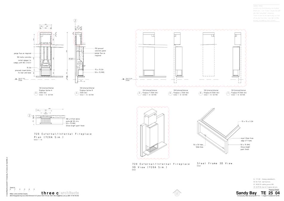
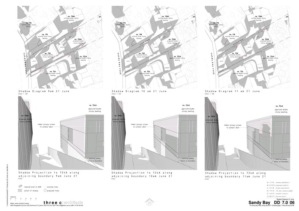
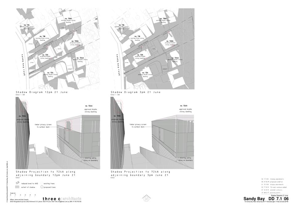
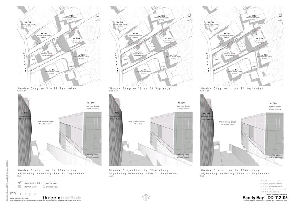
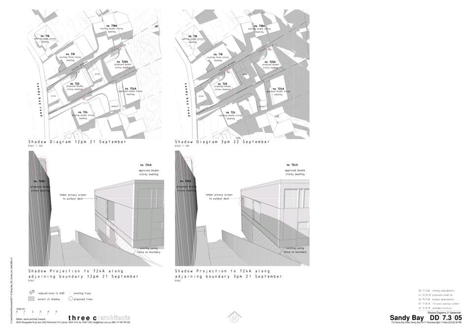
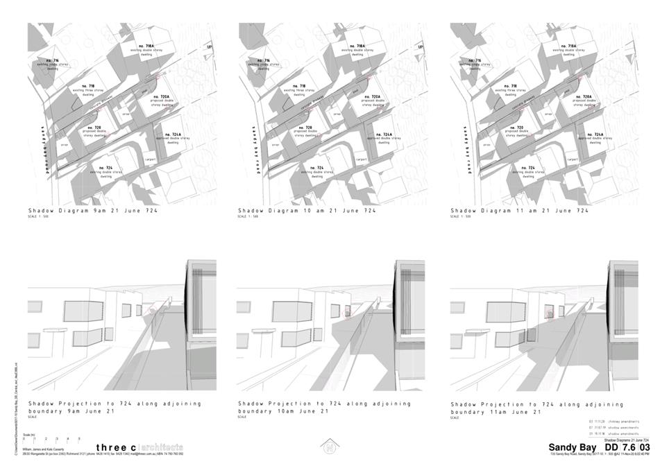
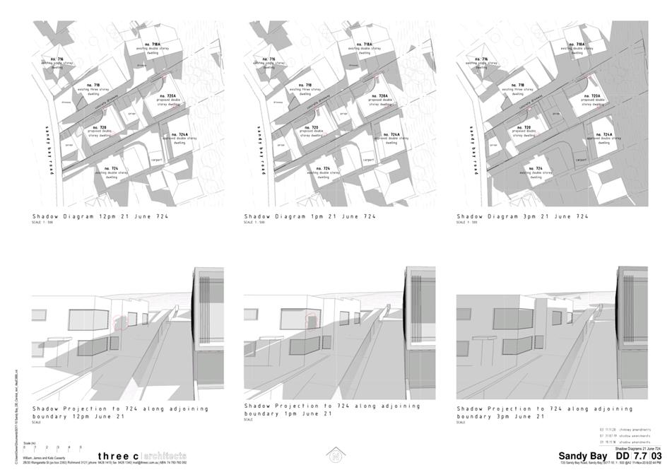
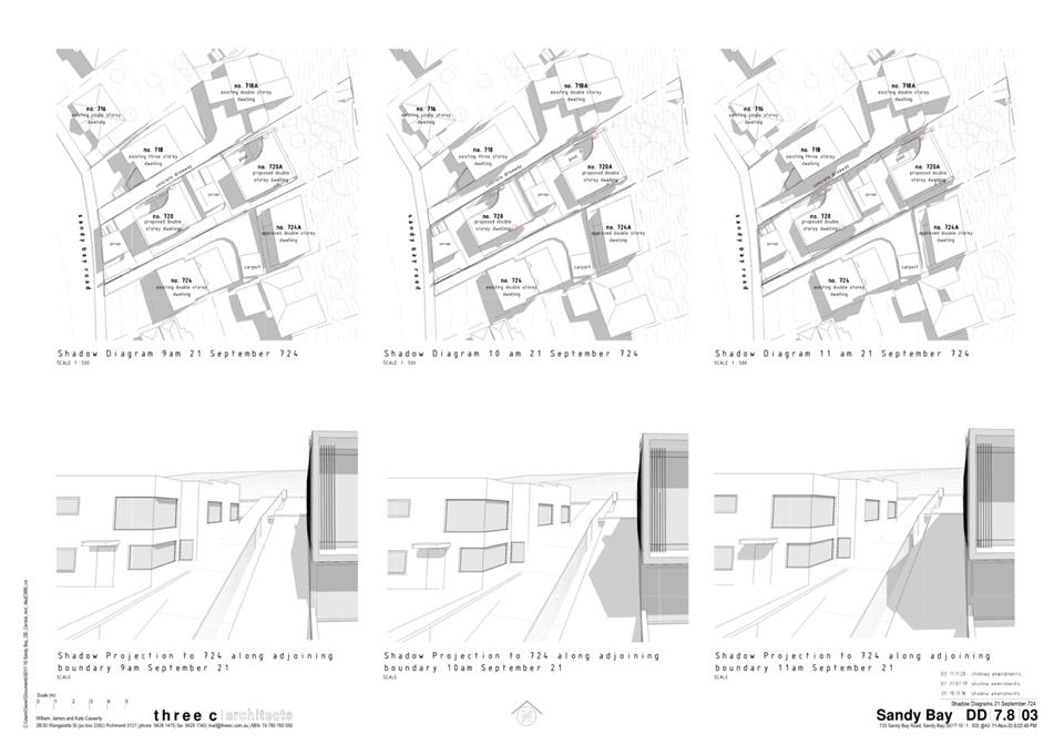
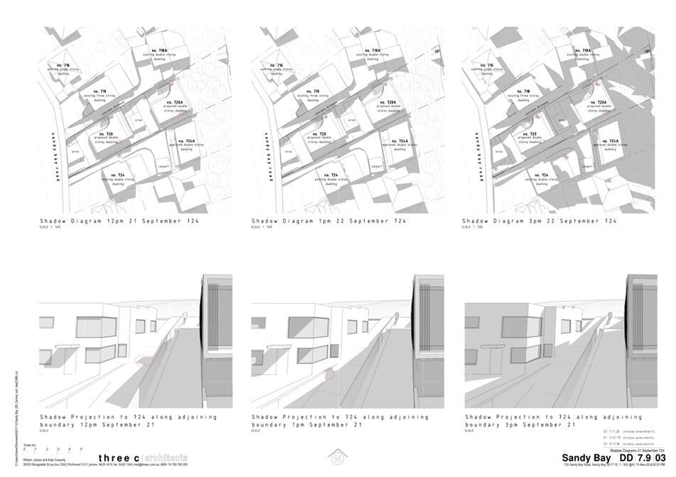
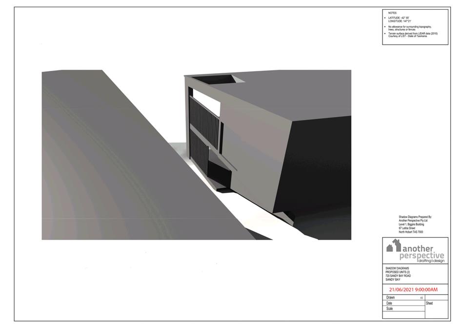
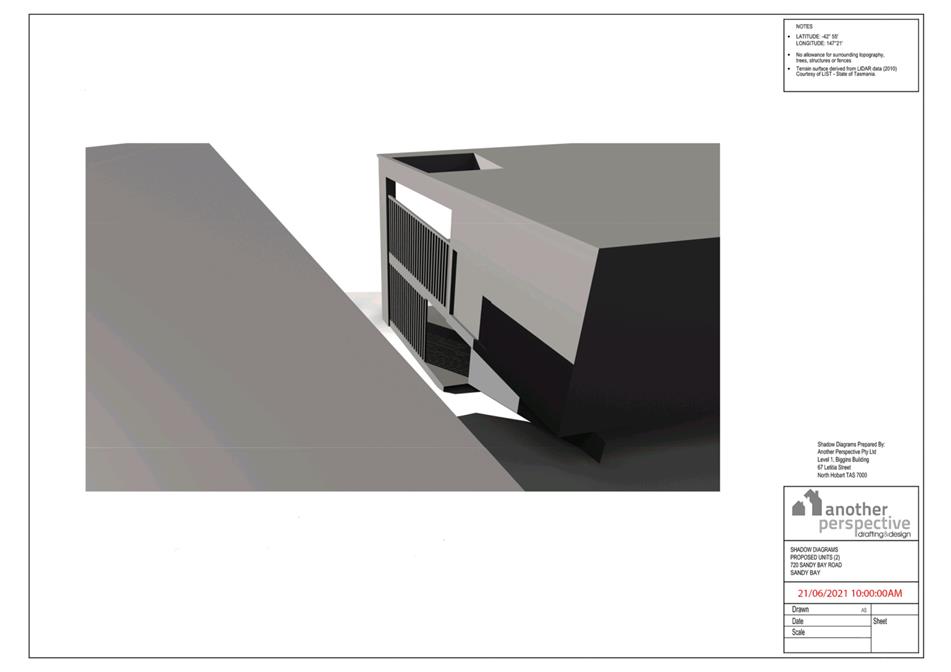
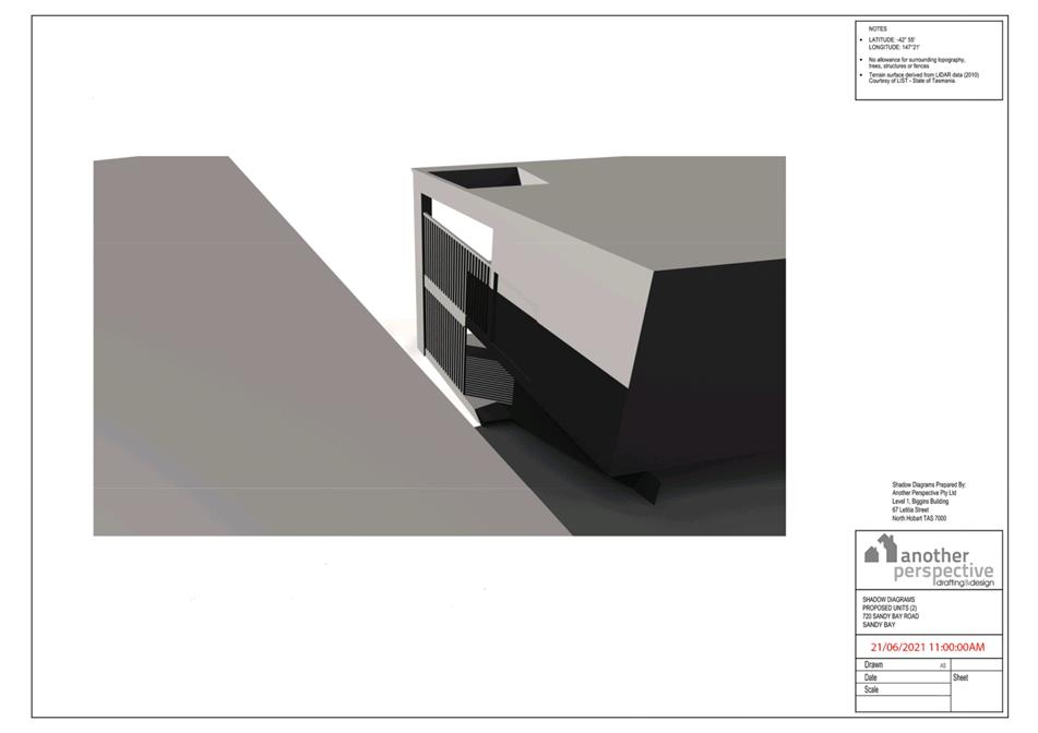
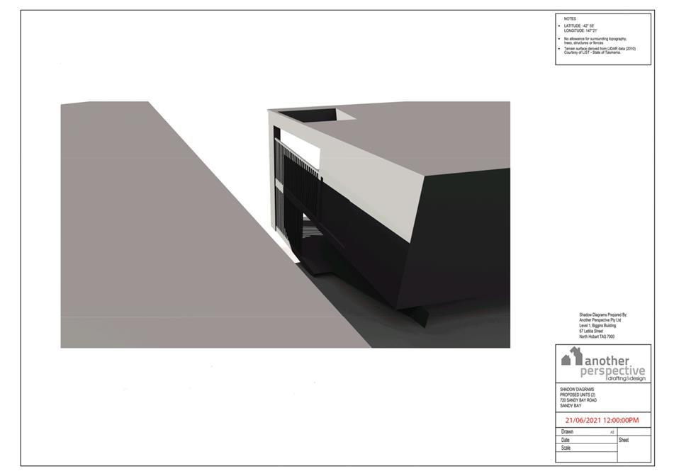
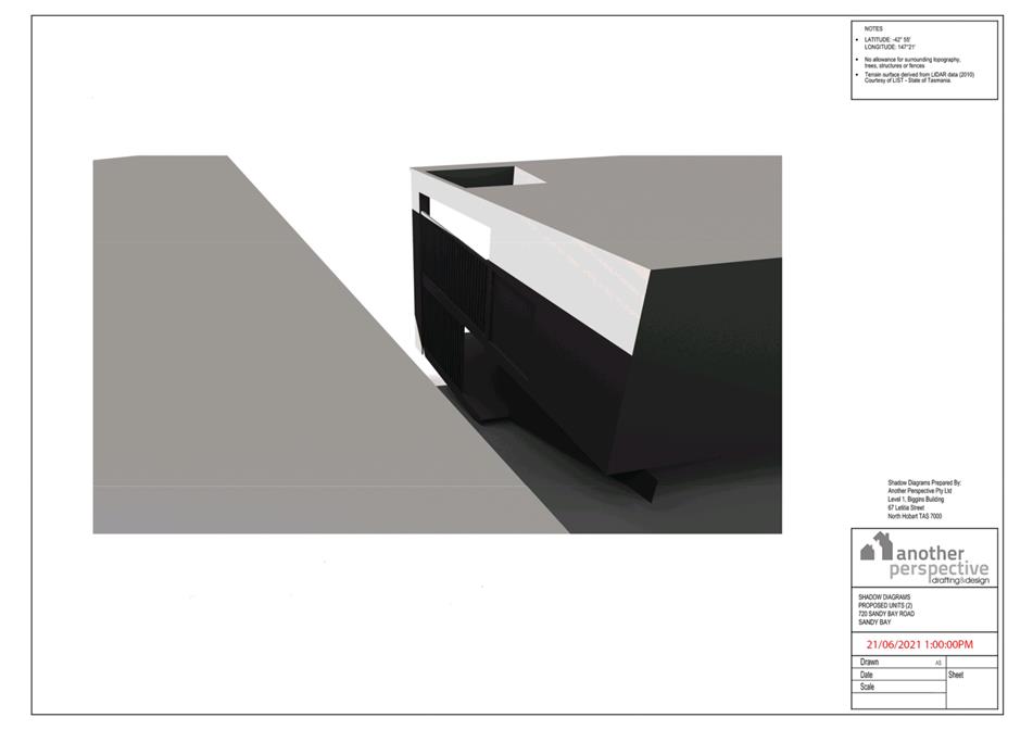
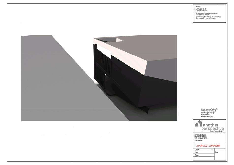
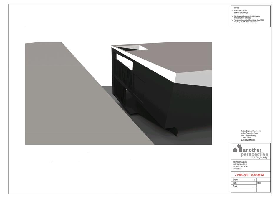
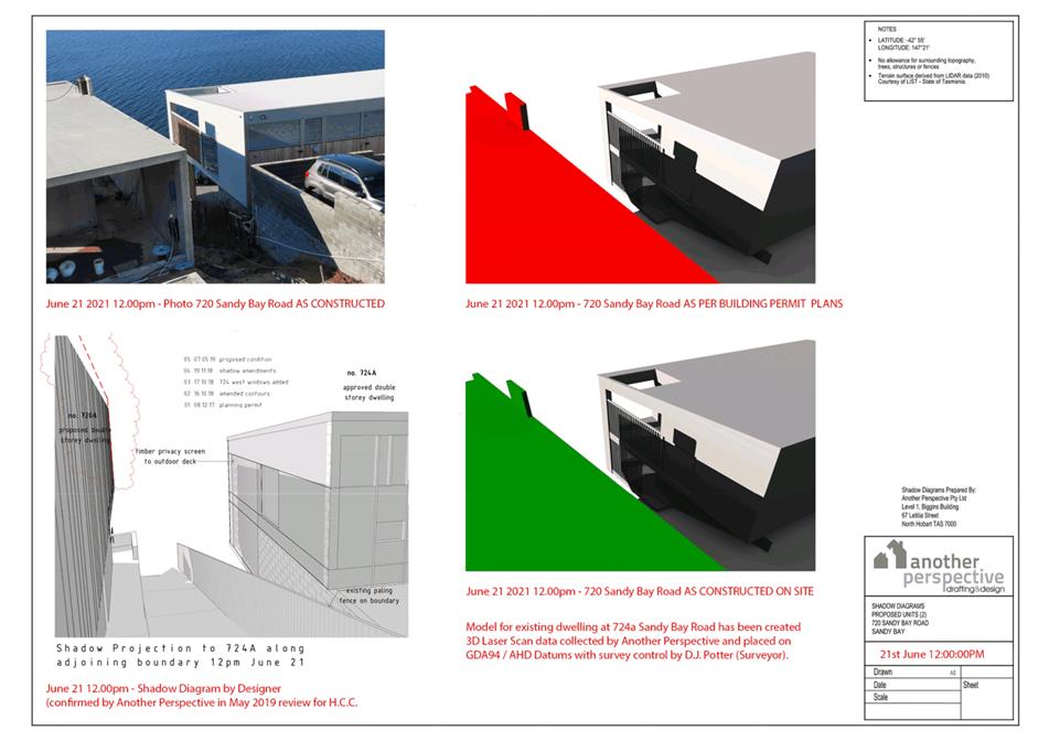
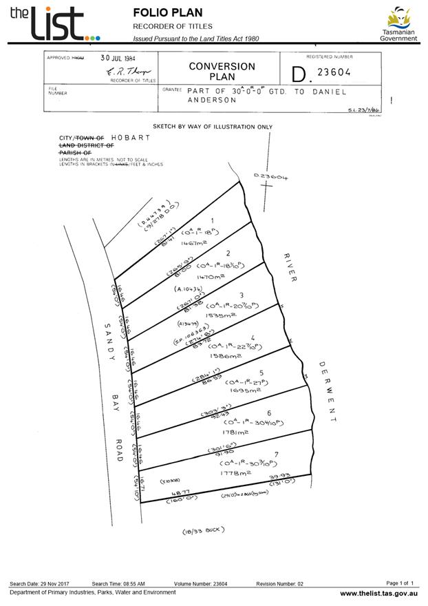
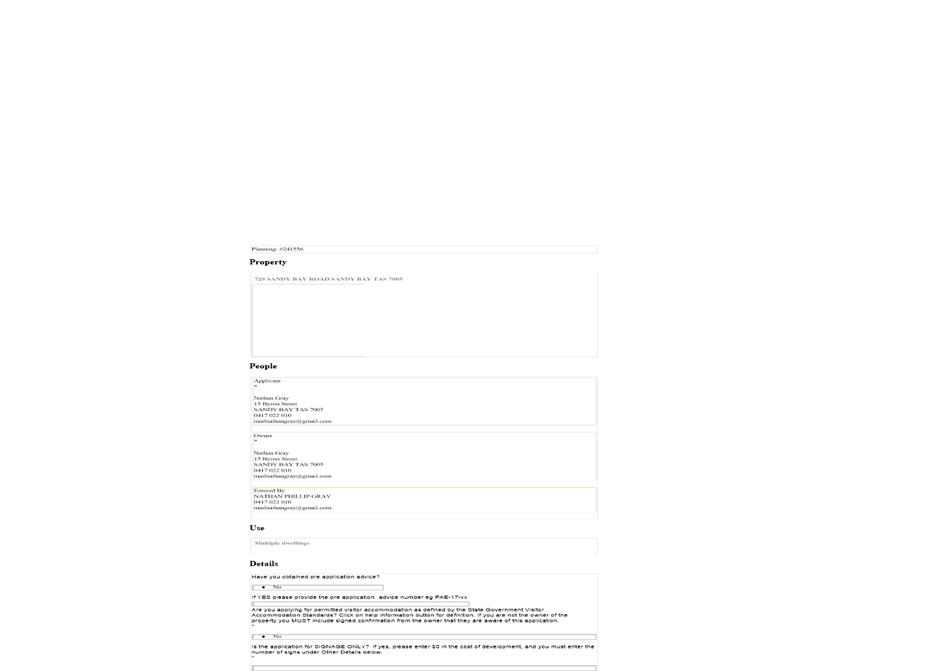
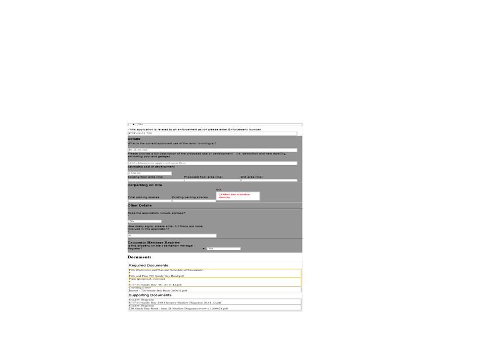
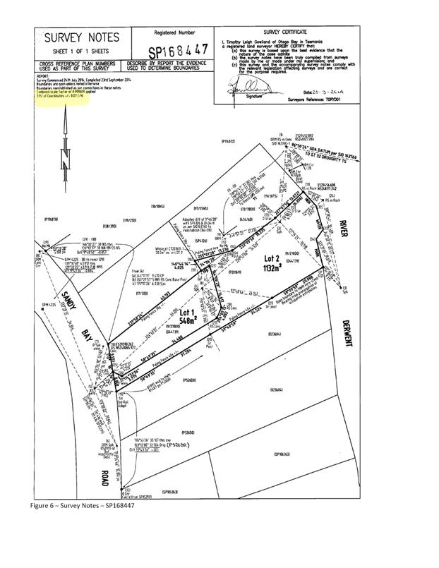
7.1.1 720 Sandy Bay Road, Sandy Bay - Alterations (Chimneys)
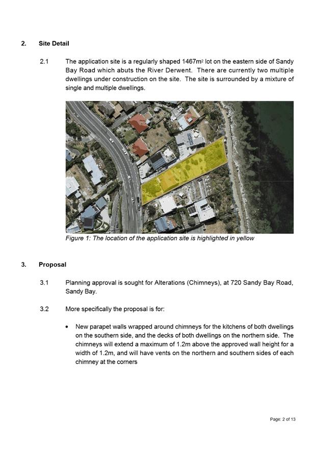
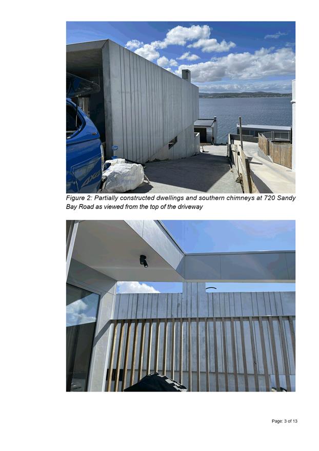
Address: 720 Sandy Bay Road, Sandy Bay
Proposal: Alterations (Chimneys)
Expiry Date: 4 April 2022
Extension of Time: Not applicable
Author: Helen Ayers
|
REcommendation That pursuant to the Hobart Interim Planning Scheme 2015, the City Planning Committee, in accordance with the delegations contained in its terms of reference, approve the application for alterations (chimneys), at 720 Sandy Bay Road, Sandy Bay 7005 for the reasons outlined in the officer’s report and a permit containing the following conditions be issued:
GEN
The use and/or development must be substantially in accordance with the documents and drawings that comprise PLN21627 720 SANDY BAY ROAD SANDY BAY TAS 7005 Final Planning Documents except where modified below.
Reason for condition
To clarify the scope of the permit.
ADVICE
The following advice is provided to you to assist in the implementation of the planning permit that has been issued subject to the conditions above. The advice is not exhaustive and you must inform yourself of any other legislation, bylaws, regulations, codes or standards that will apply to your development under which you may need to obtain an approval. Visit the Council's website for further information.
Prior to any commencement of work on the site or commencement of use the following additional permits/approval may be required from the Hobart City Council.
BUILDING PERMIT
You may need building approval in accordance with the Building Act 2016. Click here for more information.
This is a Discretionary Planning Permit issued in accordance with section 57 of the Land Use Planning and Approvals Act 1993.
NOISE REGULATIONS
Click here for information with respect to noise nuisances in residential areas.
|
Attachment a: PLN-21-627
- 720 SANDY BAY ROAD SANDY BAY TAS 7005 - Planning Committee or Delegated
Report ⇩ ![]()
Attachment
b: PLN-21-627
- 720 SANDY BAY ROAD SANDY BAY TAS 7005 - CPC Agenda Documents ⇩ ![]()
|
Item No. 7.1.1 |
Agenda (Open Portion) City Planning Committee Meeting - 21/3/2022 |
Page 22 ATTACHMENT a |

|
Agenda (Open Portion) City Planning Committee Meeting - 21/3/2022 |
Page 28 ATTACHMENT b |
|
Agenda (Open Portion) City Planning Committee Meeting |
Page 78 |
|
|
|
21/3/2022 |
|
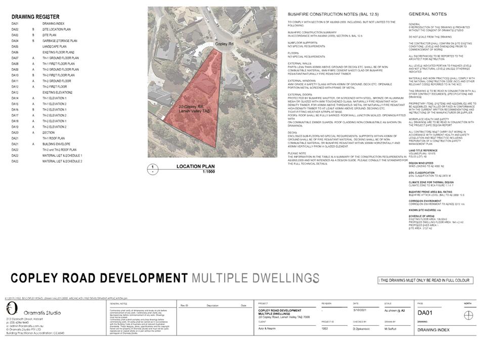
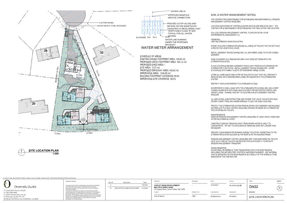
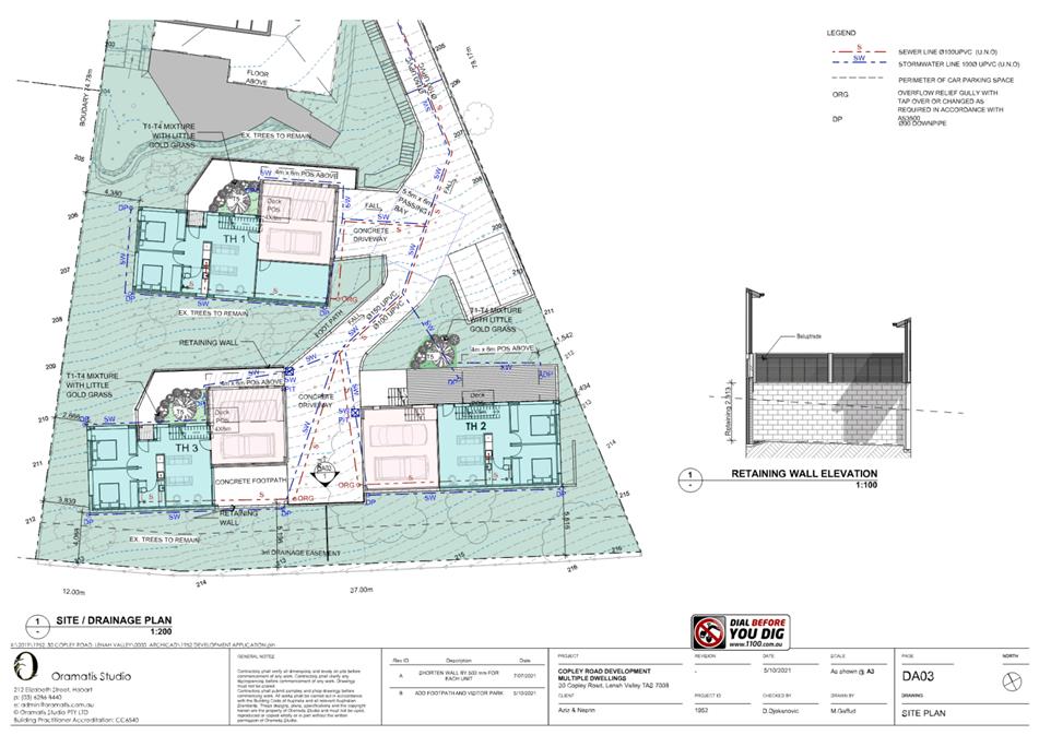
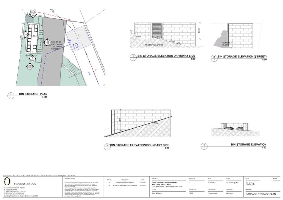
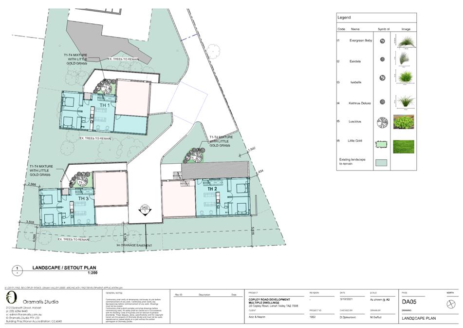
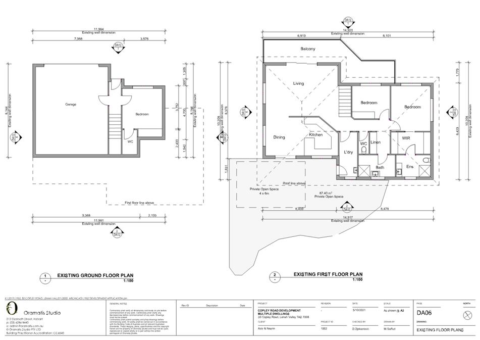
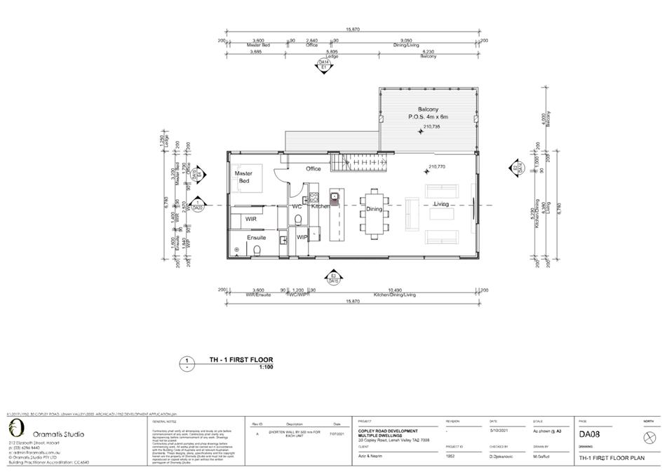
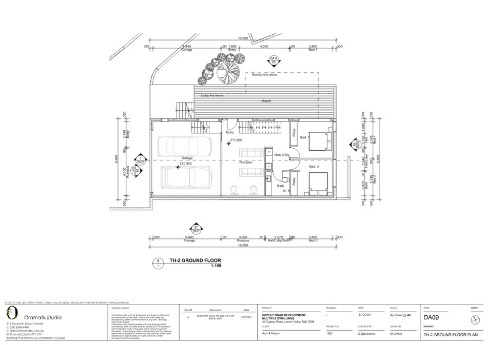
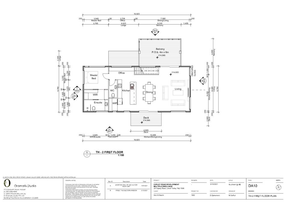
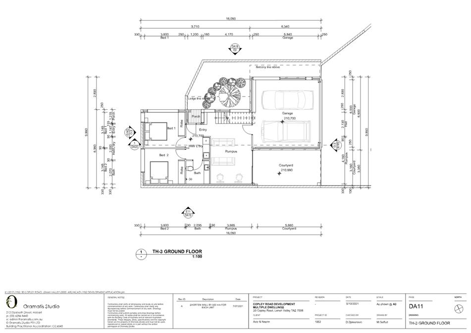
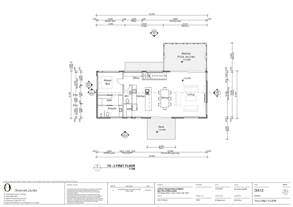
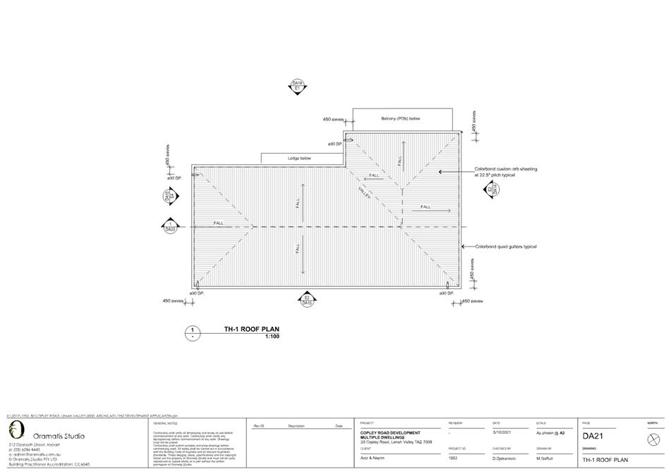
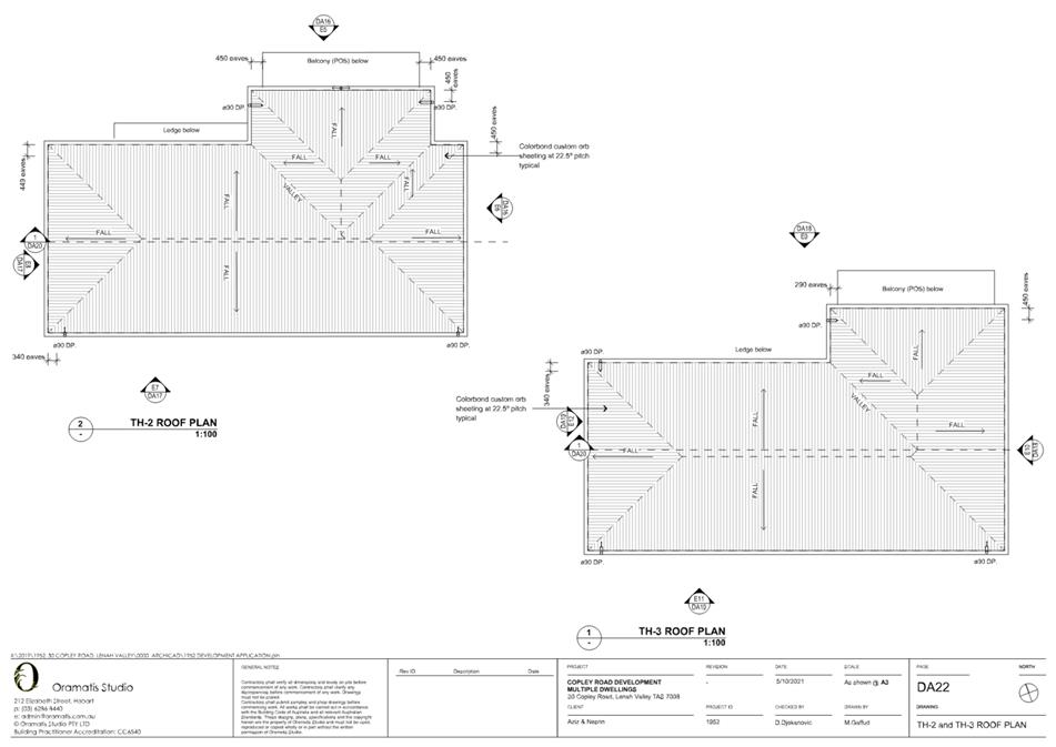
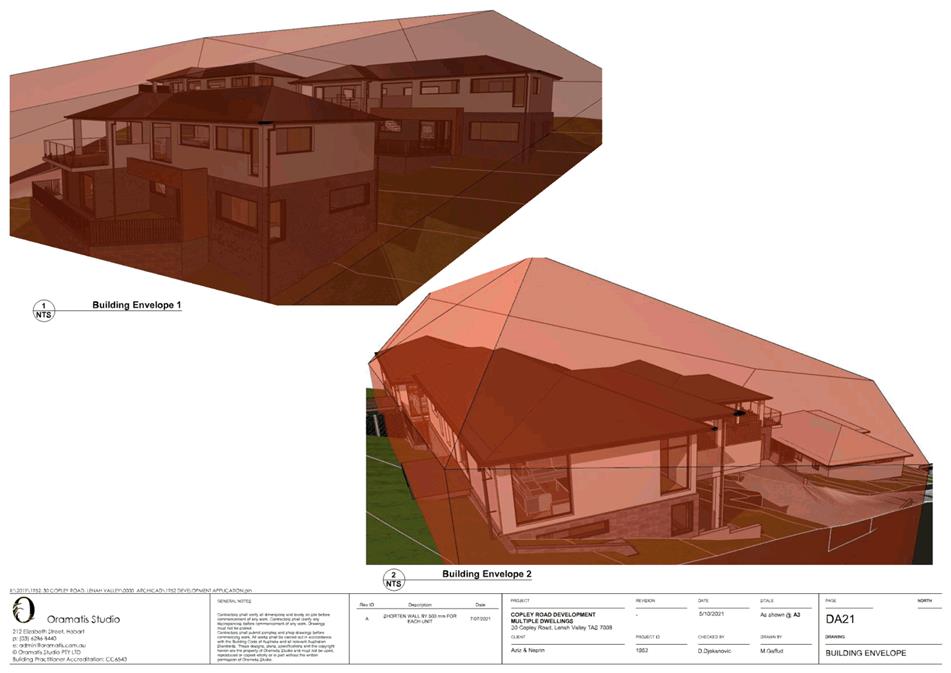
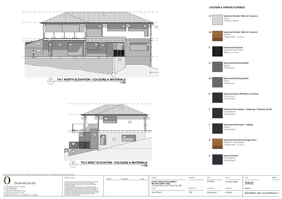
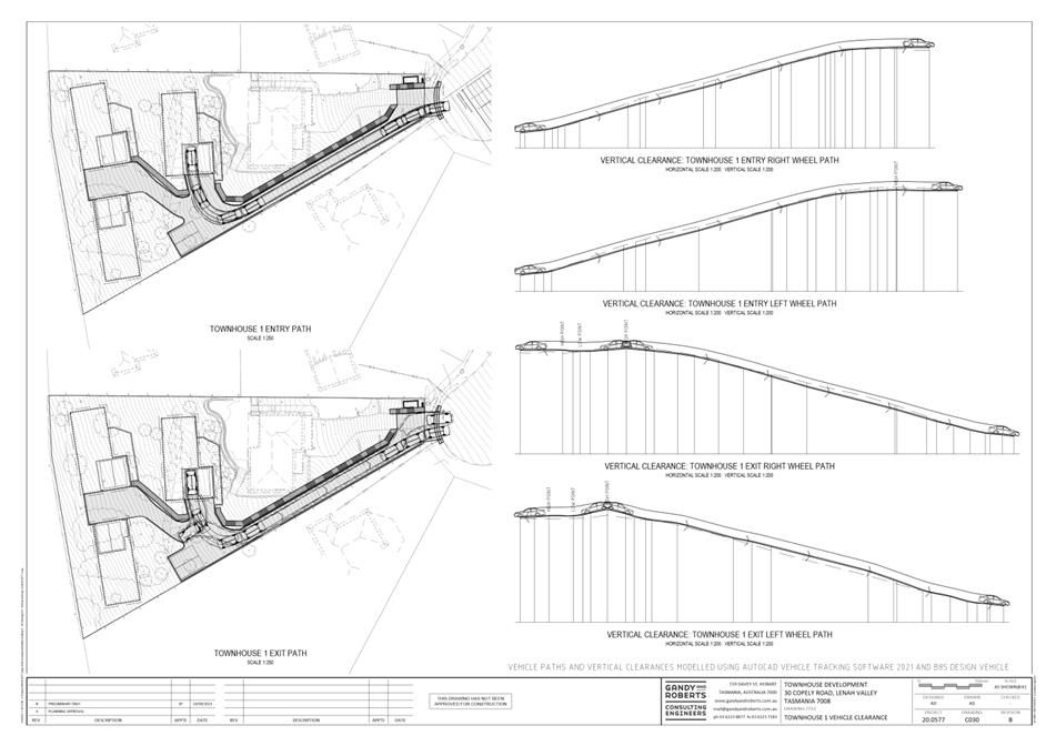
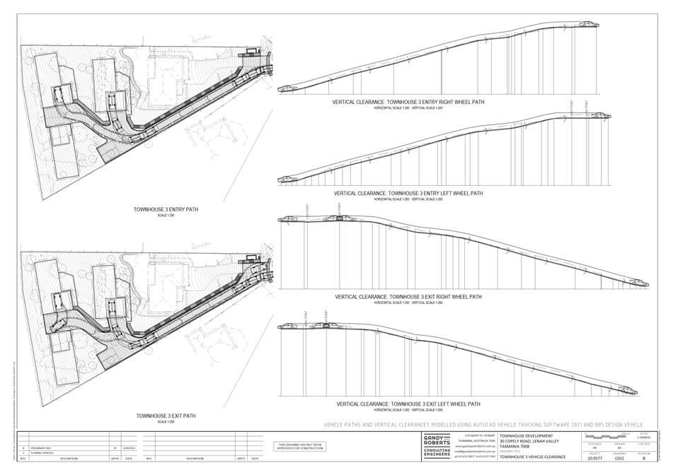
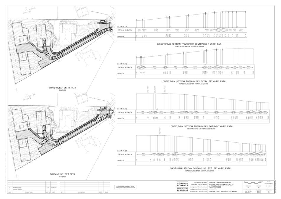
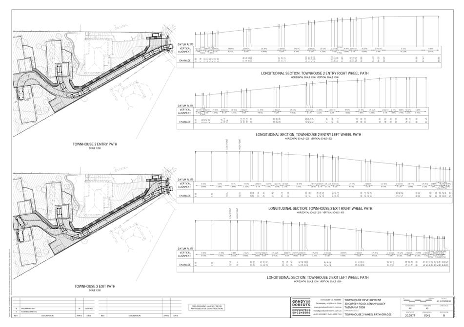
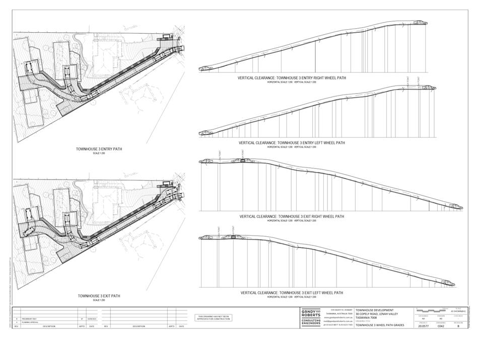
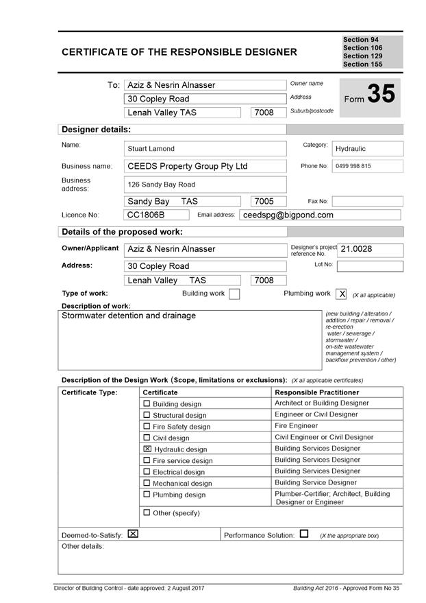
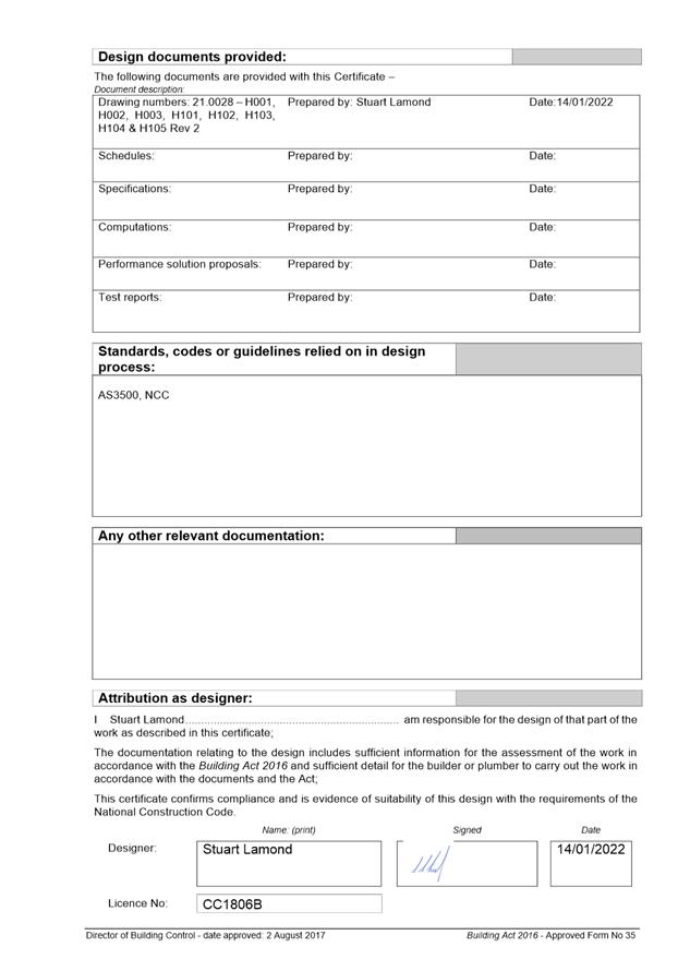
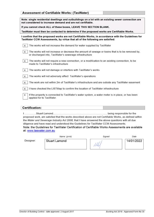
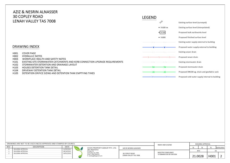
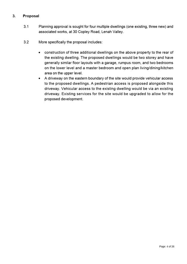
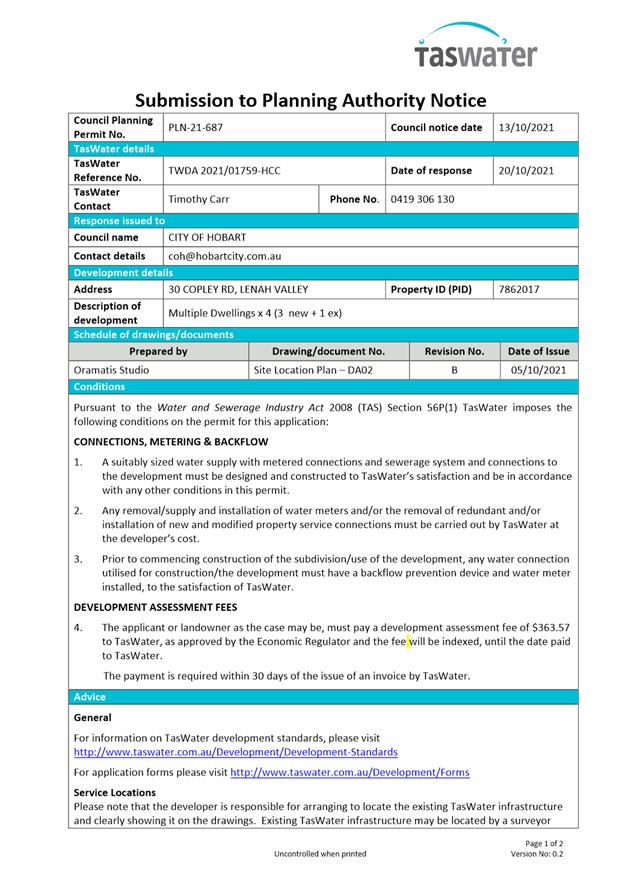
7.1.2 30 Copley Road, Lenah Valley - Four Multiple Dwellings (One Existing, Three New) and Associated Works
Address: 30 Copley Road, Lenah Valley
Proposal: Four Multiple Dwellings (One Existing, Three New) and Associated Works
Expiry Date: 18 April 2022
Extension of Time: Not applicable
Author: Adam Smee
|
REcommendation That pursuant to the Hobart Interim Planning Scheme 2015, the City Planning Committee, in accordance with the delegations contained in its terms of reference, approve the application for four multiple dwellings (one existing, three new) and associated works, at 30 Copley Road, Lenah Valley 7008, for the reasons outlined in the officer’s report and a permit containing the following conditions be issued:
GEN
The use and/or development must be substantially in accordance with the documents and drawings that comprise PLN21687 30 COPLEY ROAD LENAH VALLEY TAS 7008 Final Planning Documents except where modified below.
Reason for condition
To clarify the scope of the permit.
TW
The use and/or development must comply with the requirements of TasWater as detailed in the form Submission to Planning Authority Notice, Reference No. TWDA 2021/01759HCC dated 20/10/2021 as attached to the permit.
Reason for condition
To clarify the scope of the permit.
PLN 2
Either:
a) The
balcony on the first floor of dwelling TH 3 must be screened to at least 1.5m
above finished deck level and 33% uniform transparency, or otherwise
designed, to minimise overlooking of habitable room windows of dwelling TH1,
or, b) The
sill height of the rumpus room window within the southern elevation of
dwelling TH1 must be increased to a least 1.5m above finished floor level to
minimise overlooking from the dwelling TH3 balcony. Prior to the issue of any approval under the Building Act 2016, revised plans must be submitted and approved as a Condition Endorsement that demonstrate compliance either of the above requirements. All work required by this condition must be undertaken in accordance with the approved revised plans.
Advice:
This condition requires further information to be submitted as a Condition Endorsement. Refer to the Condition Endorsement advice at the end of this permit.
· Screening for the TH 3 balcony may include the provision of a solid or opaque balustrade.
Reason for condition
To provide reasonable opportunity for privacy for dwellings.
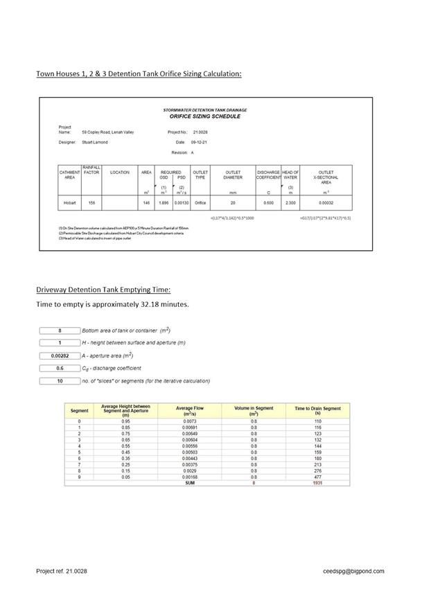
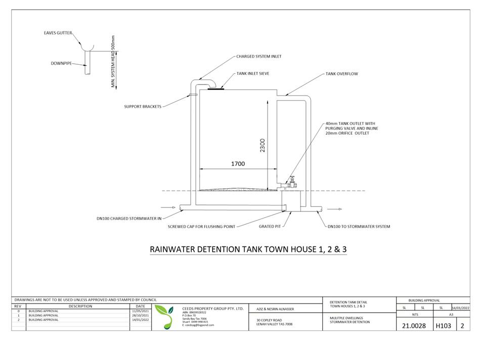
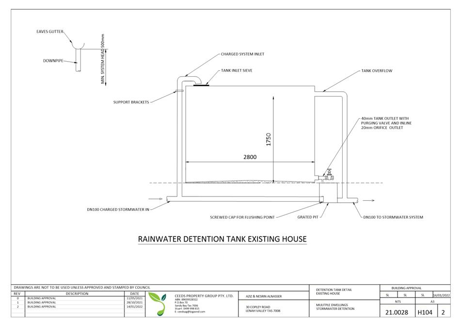
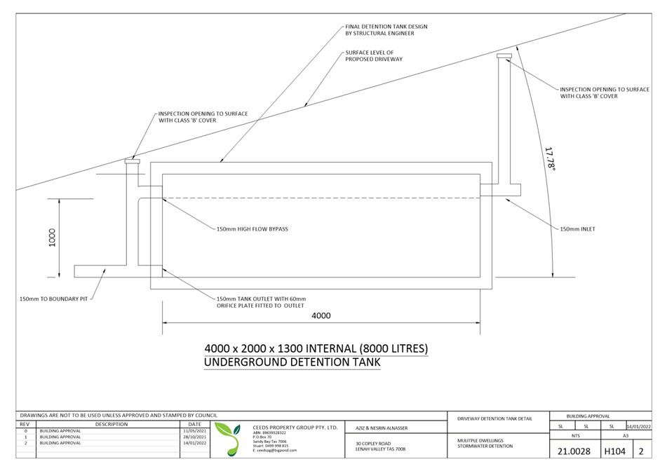
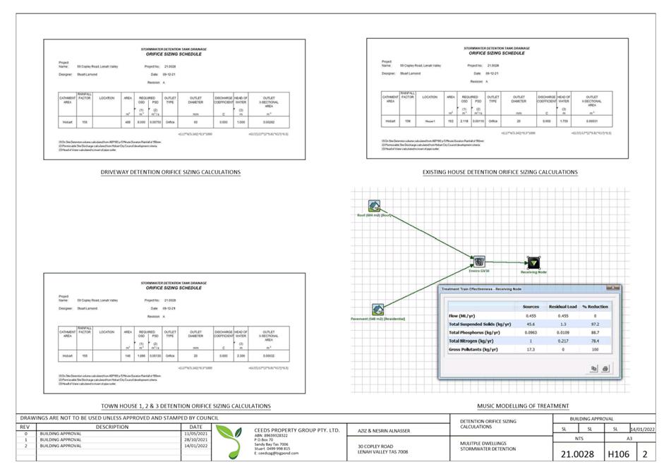
ENG sw6
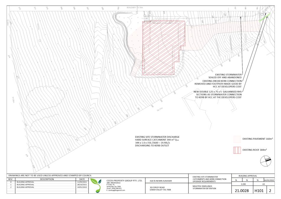
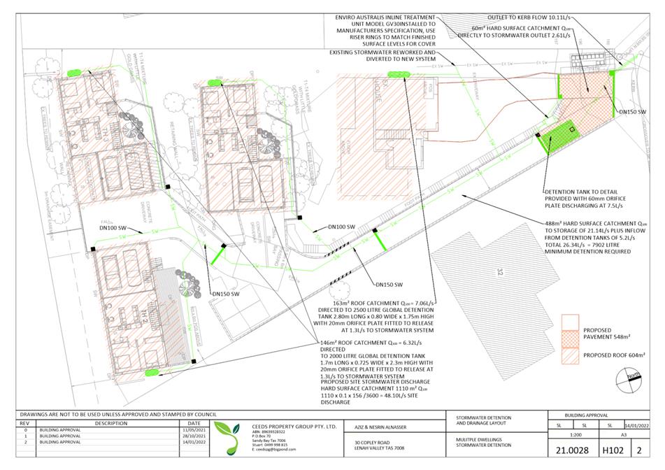
All stormwater from the proposed development (including hardstand runoff) must be discharged to the Council’s stormwater infrastructure with sufficient receiving capacity prior to first occupation. All costs associated with works required by this condition are to be met by the owner.
Design drawings and calculations of the proposed stormwater drainage and connections to the Council's stormwater infrastructure must be submitted and approved prior to the commencement of work. The design drawings and calculations must:
1. prepared
by a suitably qualified person; and 2. include long section(s)/levels and grades to the point of discharge.
All work required by this condition must be undertaken in accordance with the approved design drawings and calculations.
Advice:
The applicant is advised to submit detailed design drawings and calculations as part of their Plumbing Permit Application. If detailed design to satisfy this condition is submitted via the planning condition endorsement process there may be fees associated with the assessment, and once approved the applicant will still need to obtain a plumbing permit for the works.
Reason for condition
To ensure that stormwater from the site will be discharged to a suitable Council approved outlet.
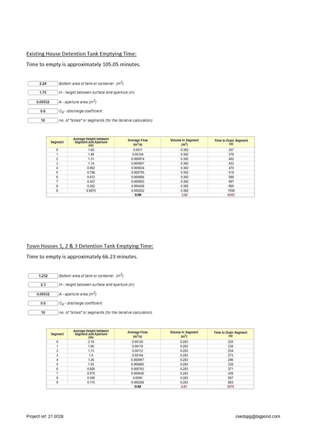
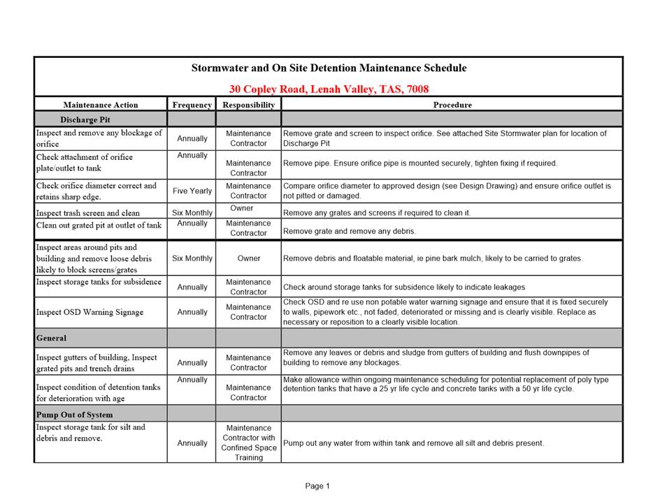
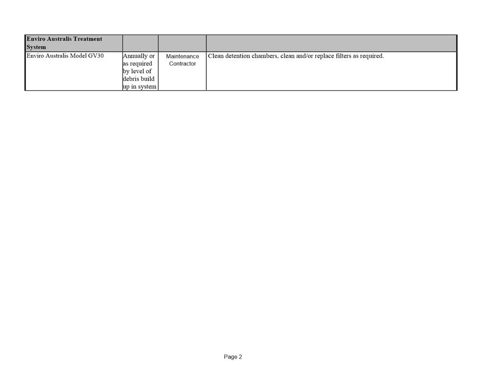
SW 9
Prior to occupancy of the development, stormwater pretreatment and detention for stormwater discharges from the development must be installed.
A stormwater management report and design must be submitted and approved prior to the issue of any approval under the Building Act 2016 or the commencement of work on the site (whichever occurs first). The stormwater management report and design must be prepared by a suitably qualified engineer and must:
1. include detailed design of the proposed treatment train, including final estimates of contaminant removal;
2. include
detailed design and supporting calculations of the detention tank showing: 1. detention
tank sizing such that there is no increase in flows from the developed site
up to 5% AEP event and no worsening of flooding; 2. the
layout, the inlet and outlet (including long section), outlet size, overflow
mechanism and invert level; 3. the
discharge rates and emptying times; and, 4. all
assumptions must be clearly stated.
3. include
a supporting maintenance plan, which specifies the required maintenance
measures to check and ensure the ongoing effective operation of all systems,
such as: 1. inspection
frequency; 2. cleanout
procedures; 3. descriptions
and diagrams of how the installed systems operate; and, 4. details of the life of assets and replacement requirements.
All work required by this condition must be undertaken and maintained in accordance with the approved stormwater management report and design.
Advice:
This condition requires further information to be submitted as a Condition Endorsement. Refer to the Condition Endorsement advice at the end of this permit.
ENG 2a
Prior to first occupation of the development, vehicular barriers compliant with the Australian Standard AS/NZS 1170.1:2002 must be installed to prevent vehicles running off the edge of an access driveway or parking module (parking spaces, aisles and manoeuvring area) where the drop from the edge of the trafficable area to a lower level is 600mm or greater, and wheel stops (kerb) must be installed for drops between 150mm and 600mm. Barriers must not limit the width of the driveway access or parking and turning areas approved under the permit.
Advice:
The Council does not consider a slope greater than 1 in 4 to constitute a lower level as described in AS/NZS 2890.1:2004 Section 2.4.5.3. Slopes greater than 1 in 4 will require a vehicular barrier or wheel stop.
Designers are advised to consult the National Construction Code 2016 to determine if pedestrian handrails or safety barriers compliant with the Code are also required in the parking module this area may be considered as a path of access to a building.
Reason for condition
To ensure the safety of users of the access driveway and parking module and compliance with the standard.
ENG 2b
Further detailed designs are required for vehicle barriers. The detailed designs must identify the following:
1. All
requirements for Vehicle Crash Barriers Identified; 2. Type of vehicle crash barriers proposed for the site with construction details.
This documentation must be submitted and approved as a condition endorsement, prior to the issue of any approval under the Building Act 2016.
The detailed designs must:
1. be
prepared and certified by a suitably qualified engineer; 2. be
in accordance with the Australian Standard AS/NZS 1170.1:2002, if
possible; and 3. show dimensions, levels, gradients, transitions, and other details as Council deem necessary to satisfy the above requirement.
The vehicle barriers must be installed in accordance with the approved detailed designs prior to first occupation.
Advice:
This condition requires further information to be submitted as a Condition Endorsement. Refer to the Condition Endorsement advice at the end of this permit.
Reason for condition
To ensure the safety of users of the access driveway and parking module and compliance with the standard.
ENG 2c
Prior to the first occupation, a suitably qualified engineer must certify that the vehicle barriers have been installed in accordance with the design drawings approved by Condition ENG 2b.
Advice:
An example certificate is available on our website.
Reason for condition
To ensure the safety of users of the access driveway and parking module and compliance with the relevant standards.
ENG 3a
The access driveway and parking area must be constructed in accordance with the following documentation which forms part of this permit: Driveway Plan / DA2154425 / REV B / 24/09/2021 received by Council on the 11th of October 2021.
Any departure from that documentation and any works which are not detailed in the documentation must be either:
(a) approved by the Director City Life, via a condition endorsement application; or
(b) designed and constructed in accordance with Australian Standard AS/NZ 2890.1:2004.
The works required by this condition must be completed prior to first occupation.
Reason for condition
To ensure the safety of users of the access and parking module, and compliance with the relevant Australian Standard.
ENG 3c
Prior to first occupation, a suitably qualified engineer must certify that the access driveway and parking area has been constructed in accordance with design drawings submitted on the 11th of October "Driveway Plans" referenced in ENG 3a.
Advice:
We strongly encourage you to speak to your engineer before works begin so that you can discuss the number and nature of the inspections they will need to do during the works in order to provide this certification. It may be necessary for a surveyor to also be engaged to ensure that the driveway will be constructed as approved.
The reason this condition has been imposed as part of your planning permit is that the driveway is outside the Australian Standard gradients or design parameters. If the driveway is not constructed as it has been approved then this may mean that the driveway will either be unsafe or will not function properly.
An example certificate is available on our website.
Reason for condition
To ensure the safety of users of the access and parking module, and compliance with the relevant Australian Standard.
ENG 4
The access driveway and parking module (car parking spaces, aisles and manoeuvring area) approved by this permit must be constructed to a sealed standard (spray seal, asphalt, concrete, pavers or equivalent Council approved) and surface drained to the Council's stormwater infrastructure prior to the first occupation / commencement of use.
Reason for condition
To ensure the safety of users of the access driveway and parking module, and that it does not detract from the amenity of users, adjoining occupiers or the environment by preventing dust, mud and sediment transport.
ENG 5
The number of car parking spaces approved to be used on the site is Eight (8).
All parking spaces (excluding those within the garages) must be delineated by means of white or yellow lines 80mm to 100mm wide, or white or yellow pavement markers in accordance with Australian Standards AS/NZS 2890.1 2004, prior to first occupation.
Reason for condition
To ensure the provision of parking for the use is safe and efficient.
ENG 1
Any damage to council infrastructure resulting from the implementation of this permit, must, at the discretion of the Council:
1. Be
met by the owner by way of reimbursement (cost of repair and reinstatement to
be paid by the owner to the Council); or 2. Be repaired and reinstated by the owner to the satisfaction of the Council.
A photographic record of the Council's infrastructure adjacent to the subject site must be provided to the Council prior to any commencement of works.
A photographic record of the Council’s infrastructure (e.g. existing property service connection points, roads, buildings, stormwater, footpaths, driveway crossovers and nature strips, including if any, preexisting damage) will be relied upon to establish the extent of damage caused to the Council’s infrastructure during construction. In the event that the owner/developer fails to provide to the Council a photographic record of the Council’s infrastructure, then any damage to the Council's infrastructure found on completion of works will be deemed to be the responsibility of the owner.
Reason for condition
To ensure that any of the Council's infrastructure and/or siterelated service connections affected by the proposal will be altered and/or reinstated at the owner’s full cost.
ENG s3
Any excavation and earthretaining structures (i.e. embankments, cuttings, retaining walls) and footings must be contained wholly within the property boundary, be adequately drained and must not undermine the stability and integrity of the highway reservation or neighbouring properties. Detailed design drawings and structural certificates must be submitted and approved as a Condition Endorsement prior to the issuing of any building approval to satisfy the above requirement. Detailed design and structural certificates must:
1. Be
prepared and certified by a suitable qualified person and experienced
engineer; 2. Be
designed in accordance with AS 4678-2002, Earthretaining Structures; 3. Take
into account any additional surcharge loadings as required by relevant
Australian Standards; 4. Take
into account and reference accordingly any Geotechnical findings; 5. Detail
any mitigation measures required; and 6. Detail the design and location of the excavation, earthretaining structures and footings adjacent to the highway reservation and property boundaries;
The structure certificated and/or drawings should note accordingly the above
All work required by this condition must be undertaken in accordance with the approved select design drawing and structural certificates.
Advice:
This condition requires further information to be submitted as a Condition Endorsement. Refer to the Condition Endorsement advice at the end of this permit.
Reason for condition
To ensure that the stability and integrity of the Council’s highway reservation and neighbouring properties are not compromised by the development.
ENV 2
Sediment and erosion control measures, in accordance with an approved soil and water management plan (SWMP), must be installed prior to the commencement of work and maintained until such time as all disturbed areas have been stabilised and/or restored or sealed to the Council’s satisfaction.
A SWMP must be submitted as a Condition Endorsement prior to the issue of any approval under the Building Act 2016 or the commencement of work, whichever occurs first. The SWMP must be prepared in accordance with the Soil and Water Management on Building and Construction Sites fact sheets (Derwent Estuary Program, 2008), available here.
All work required by this condition must be undertaken in accordance with the approved SWMP.
Advice:
This condition requires further information to be submitted as a Condition Endorsement. Refer to the Condition Endorsement advice at the end of this permit.
Reason for condition
To avoid the pollution and sedimentation of roads, drains and natural watercourses that could be caused by erosion and runoff from the development.
ADVICE
The following advice is provided to you to assist in the implementation of the planning permit that has been issued subject to the conditions above. The advice is not exhaustive and you must inform yourself of any other legislation, bylaws, regulations, codes or standards that will apply to your development under which you may need to obtain an approval. Visit the Council's website for further information.
Prior to any commencement of work on the site or commencement of use the following additional permits/approval may be required from the Hobart City Council.
BUILDING PERMIT
You may need building approval in accordance with the Building Act 2016. Click here for more information.
This is a Discretionary Planning Permit issued in accordance with section 57 of the Land Use Planning and Approvals Act 1993.
PLUMBING PERMIT
You may need plumbing approval in accordance with the Building Act 2016, Building Regulations 2016 and the National Construction Code. Click here for more information.
NEW SERVICE CONNECTION
Please contact the Hobart City Council's City Amenity Division to initiate the application process for your new stormwater connection.
STORM WATER
Please note that in addition to a building and/or plumbing permit, development must be in accordance with the Hobart City Council’s Infrastructure By law. Click here for more information.
WORK WITHIN THE HIGHWAY RESERVATION
Please note development must be in accordance with the Hobart City Council’s Infrastructure By law. Click here for more information.
FEES AND CHARGES
Click here for information on the Council's fees and charges.
|
Attachment
a: PLN-21-687
- 30 COPLEY ROAD LENAH VALLEY TAS 7008 - Planning Committee or Delegated Report ⇩ ![]()
Attachment
b: PLN-21-687
- 30 COPLEY ROAD LENAH VALLEY TAS 7008 - CPC Agenda Documents ⇩ ![]()
|
Item No. 7.1.2 |
Agenda (Open Portion) City Planning Committee Meeting - 21/3/2022 |
Page 104 ATTACHMENT a |
|
Agenda (Open Portion) City Planning Committee Meeting - 21/3/2022 |
Page 110 ATTACHMENT b |

|
Agenda (Open Portion) City Planning Committee Meeting |
Page 170 |
|
|
|
21/3/2022 |
|
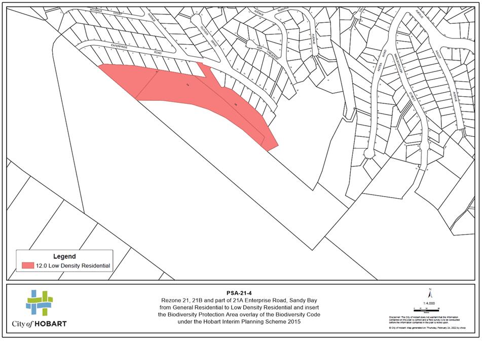
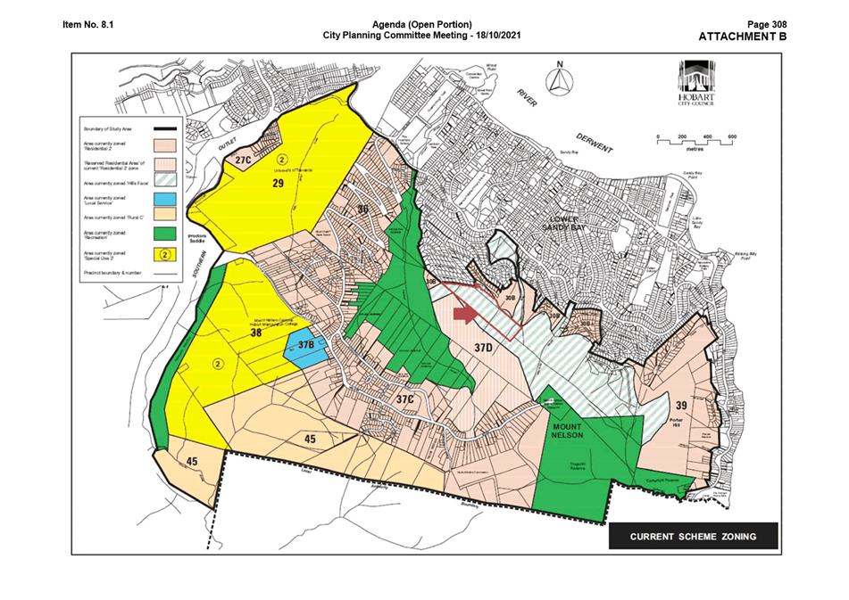
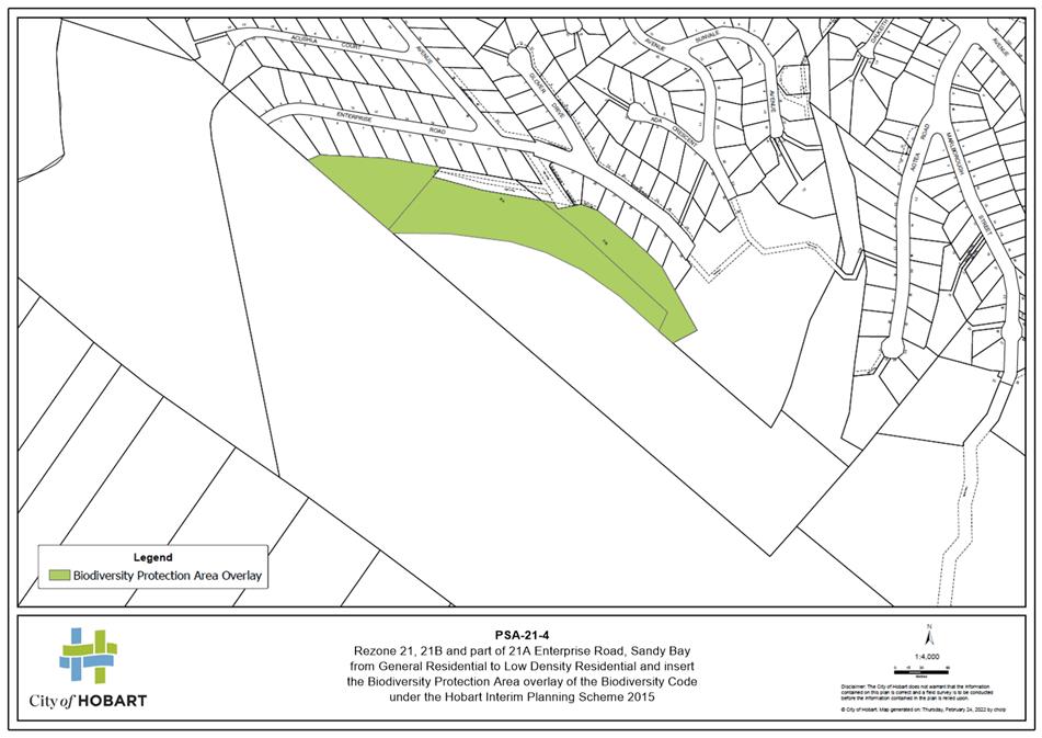
7.1.3 Amendment PSA-21-4 - Hobart Interim Planning Scheme 2015 - 21, 21B and part of 21A Enterprise Road, Sandy Bay Rezoning
Report of the Acting Director City Life of 8 March 2022 and attachments.
Delegation: Council
|
Item No. 7.1.3 |
Agenda (Open Portion) City Planning Committee Meeting |
Page 188 |
|
|
21/3/2022 |
|
REPORT TITLE: Amendment PSA-21-4 - Hobart Interim Planning Scheme 2015 - 21, 21B and part of 21A Enterprise Road, Sandy Bay Rezoning
REPORT PROVIDED BY: Acting Director City Life
1. Report Purpose and Community Benefit
1.1. The purpose of this report is to analyse the planning merit of amending the Hobart Interim Planning Scheme 2015 (HIPS 2015) by rezoning 21, 21B and part of 21A Enterprise Road, Sandy Bay (the site) from the General Residential Zone to the Low Density Residential Zone.
1.2. The report has been prepared in response to Council’s resolution of 25 October 2021.
1.3. The proposal benefits the community by ensuring that land is appropriately zoned and that use and development is undertaken in a fair and orderly manner.
2. Report Summary
2.1. The proposal is to rezone the site (folios of the Register 175781/1, 175780/1 and 169834/40) from General Residential to Low Density Residential.
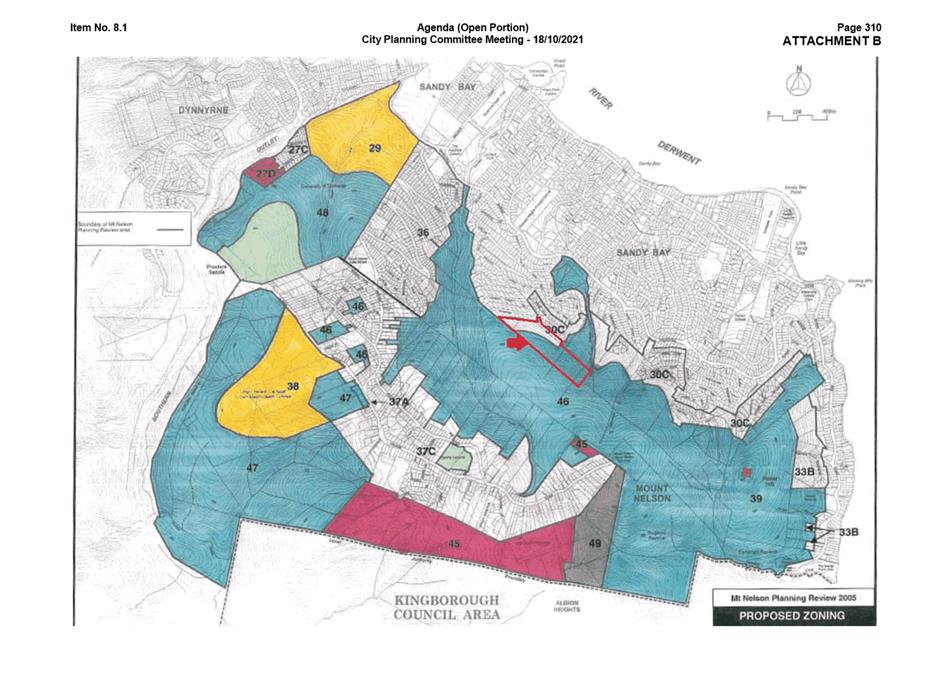
2.2. The proposed rezoning plan is provided as Attachment A.
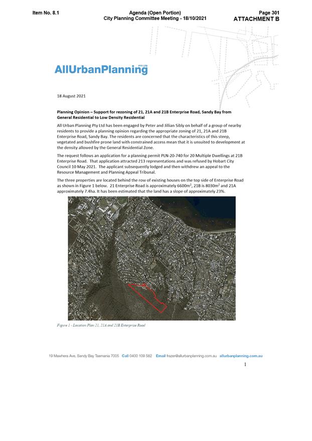
2.3. The site is located at the top of Enterprise Road and adjoins open space along Lambert Rivulet known as Bicentennial Park.
2.4. Access to the site is via a right of way off Enterprise Road.
2.5. The land is generally steep, with gradients of around 25º (47%) at the south-eastern end of the land and 16º (29%) at the north-western end.
2.6. The dominant vegetation Eucalyptus pulchella dry forest and woodland (DPU).
|
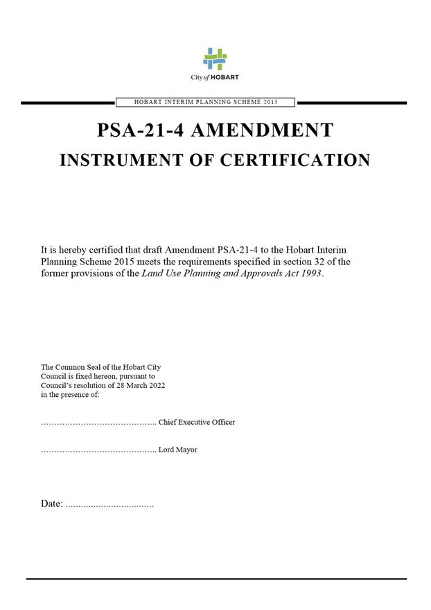
That: 1. Pursuant to section 34(1)(b) of the former provisions of the Land Use Planning and Approvals Act 1993, Council resolve to initiate an amendment to the Hobart Interim Planning Scheme 2015 to rezone the properties at 21, 21B and part of 21A Enterprise Road, Sandy Bay from General Residential to Low Density Residential, and apply the Biodiversity Protection Area overlay under the Biodiversity Code to the site with the exception of the right of way, as indicated in the rezoning plan provided in Attachment A. 2. Pursuant to section 35 of the former provisions of the Land Use Planning and Approvals Act 1993, Council certify that amendment PSA-21-4 to the Hobart Interim Planning Scheme 2015 meets the requirements of section 32 of the former provisions of the Land Use Planning and Approvals Act 1993 and authorise the Chief Executive Officer and Lord Mayor to sign the Instrument of Certification (Attachment D). 3. Pursuant to section 38 of the former provisions of the Land Use Planning and Approvals Act 1993, the Council place amendment PSA-21-4 to the Hobart Interim Planning Scheme on public exhibition for a 28 day period following certification.
|
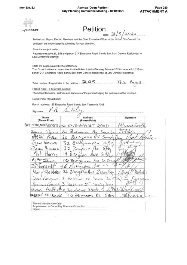
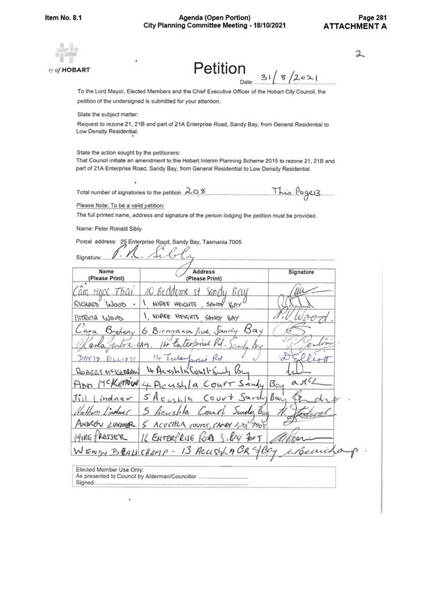
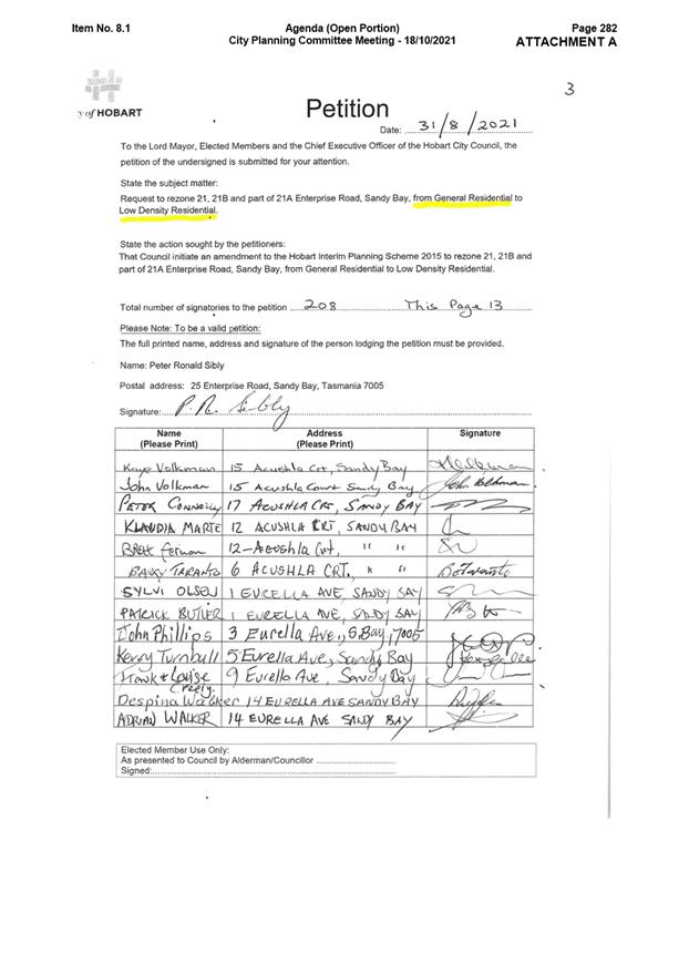
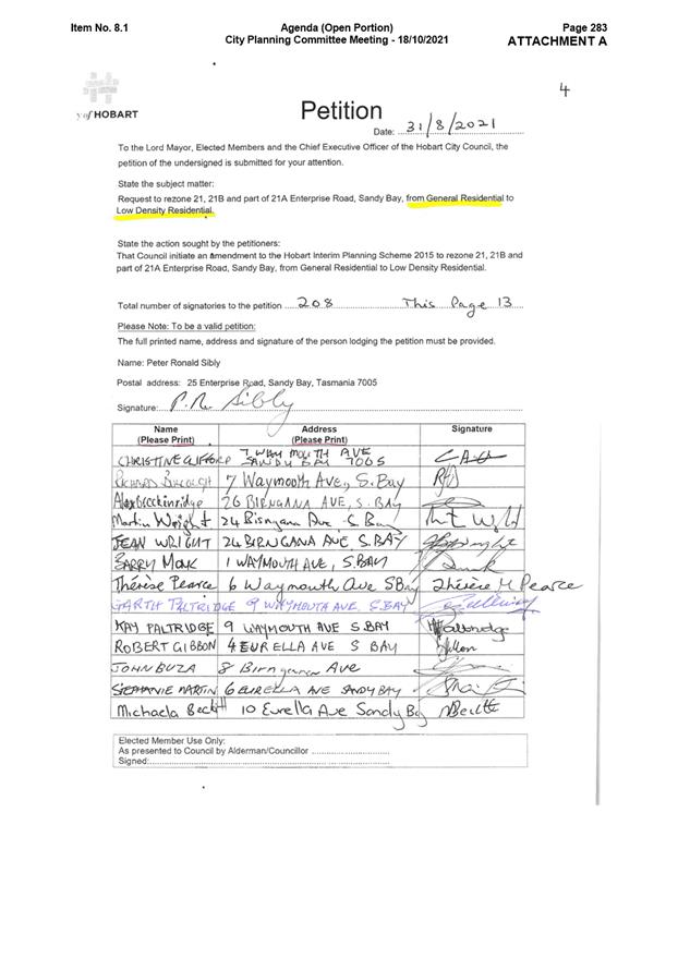
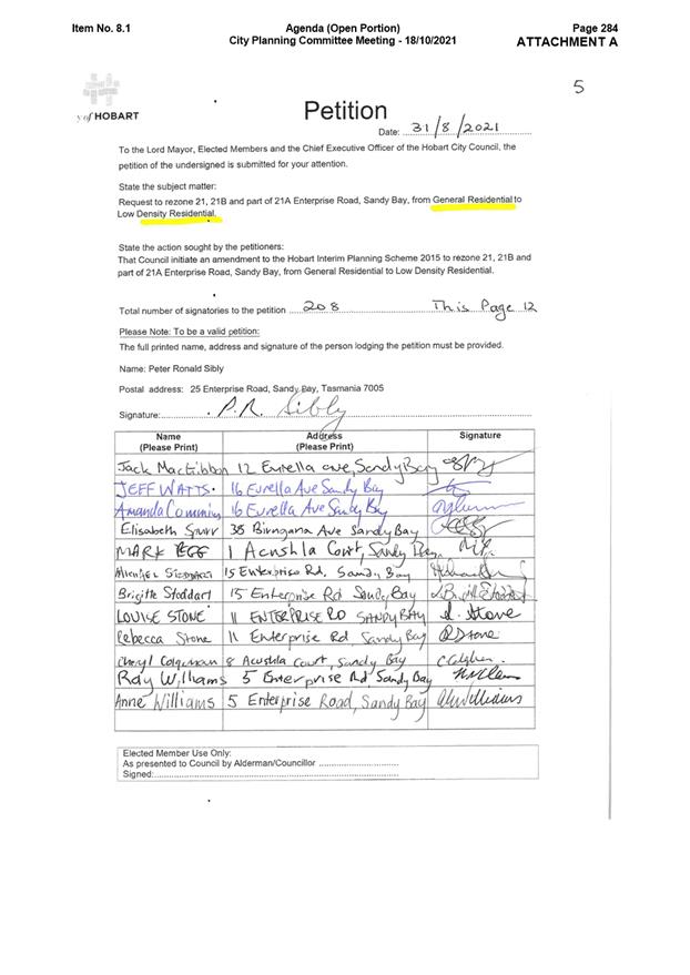
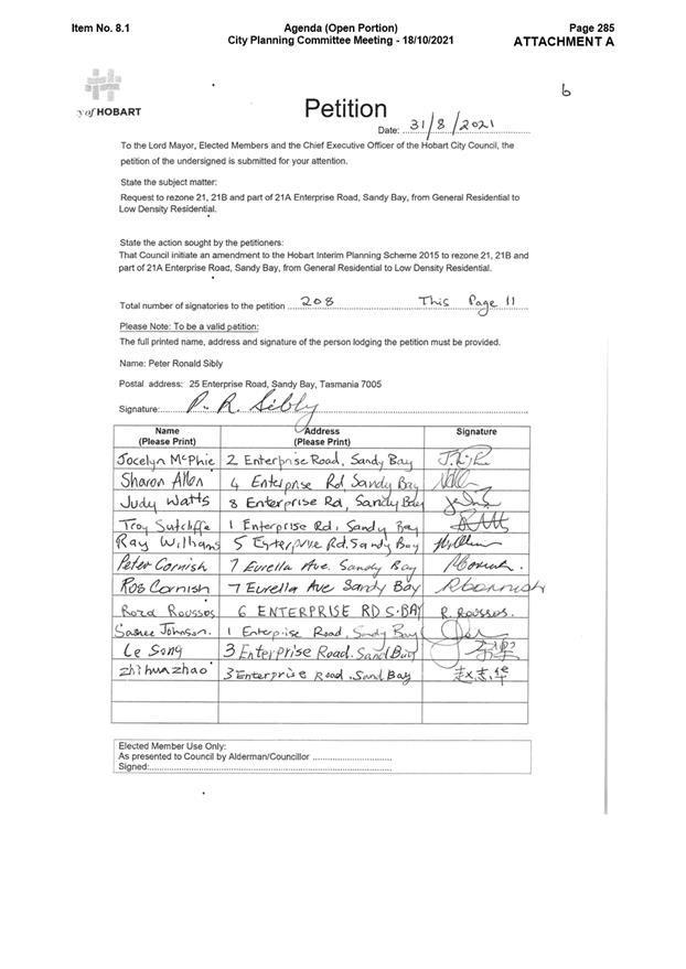
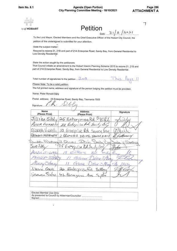
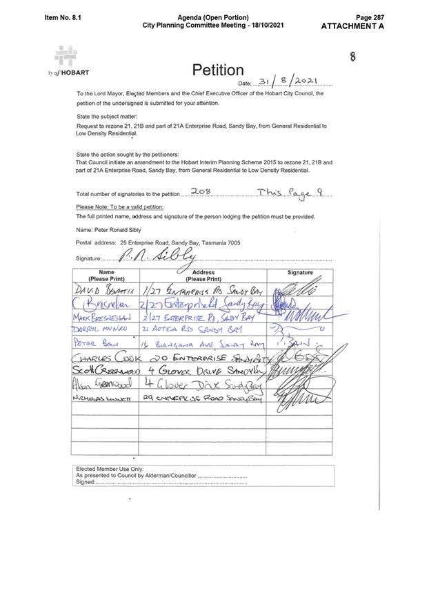
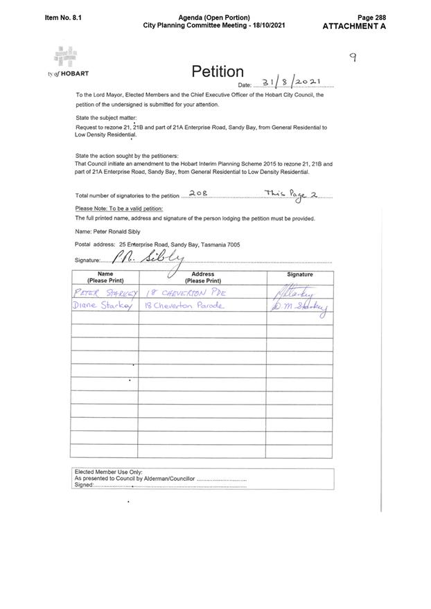
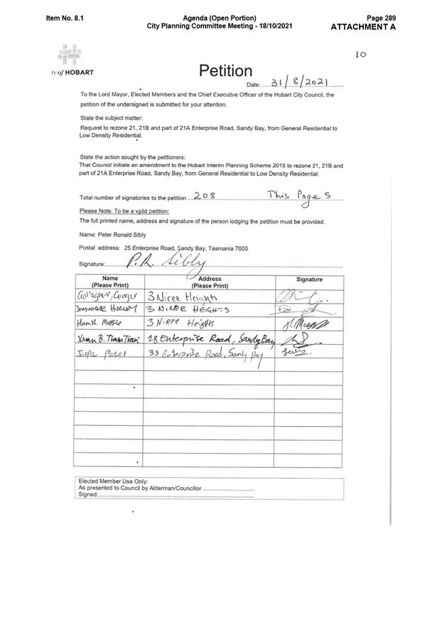
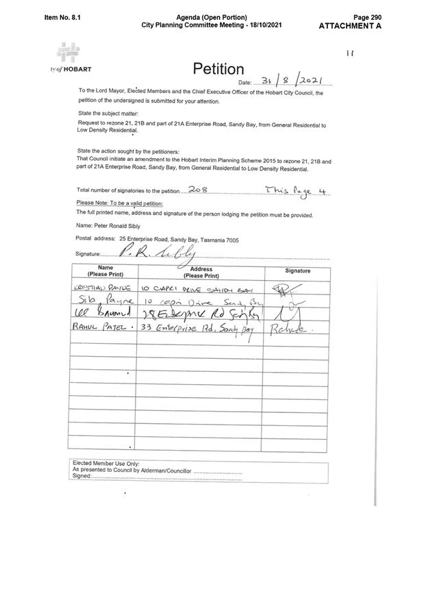
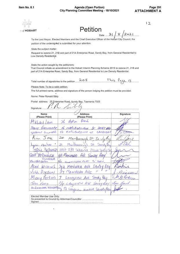
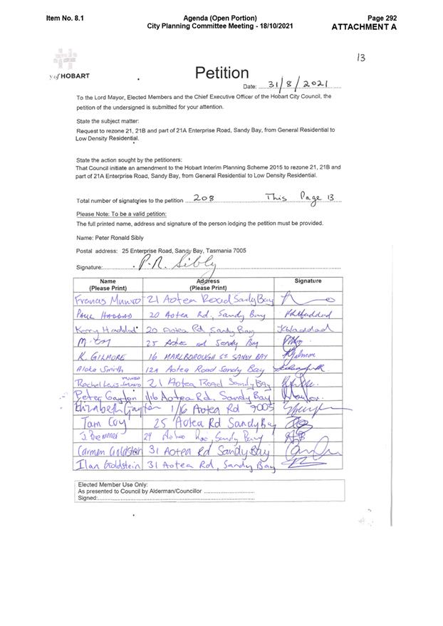
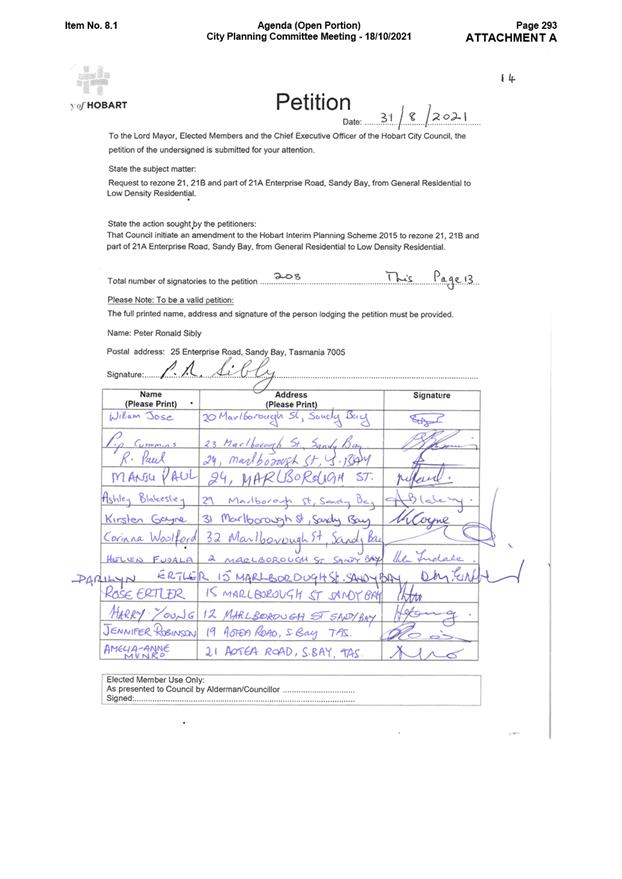
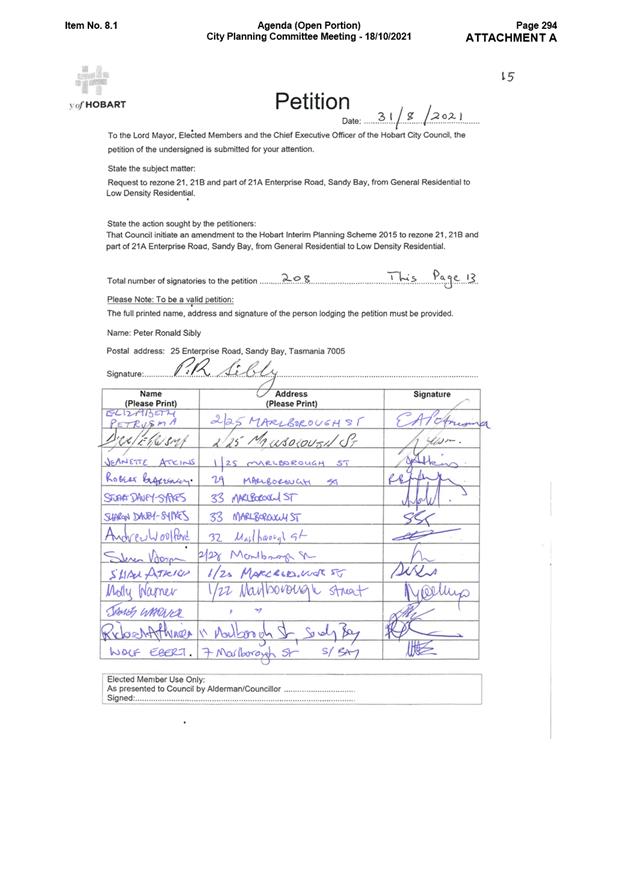
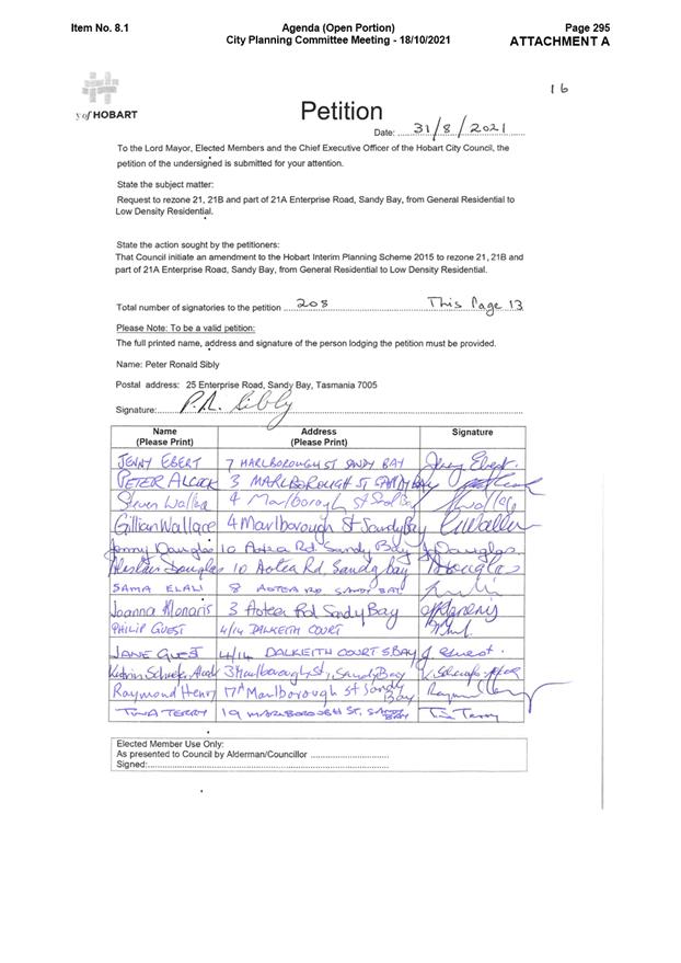
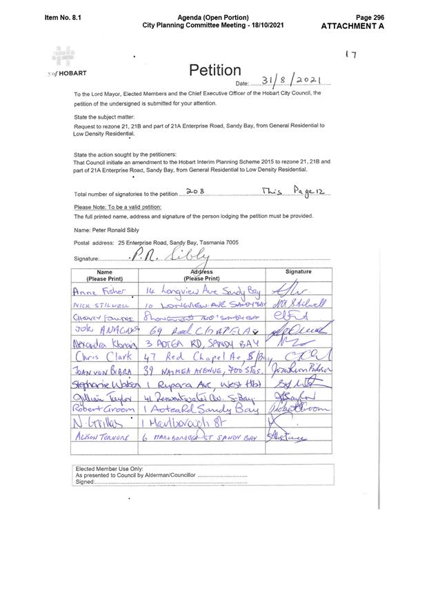
4. Background
4.1. A petition calling for Council to rezone 21, 21B and part of 21A Enterprise Road, Sandy Bay from General Residential to Low Density Residential was presented to Council at its meeting on 6 September 2021.
4.2. The petition was discussed at the City Planning Committee meeting on 18 October 2021 and Council meeting on 25 October 2021 (Attachment B).
4.3. Council resolved the following:
That a report analysing the zoning of 21, 21B and part of 21A Enterprise Road, Sandy Bay and recommending whether to initiate a planning scheme amendment to rezone the land from General Residential to Low Density Residential be prepared as a matter of high priority and no later than within the month of March.
4.4. In recent years one development application has been lodged at the site which was for 20 multiple dwellings and associated works on 21B Enterprise Road (PLN-20-740). The application was refused by Council at its meeting of 10 May 2021.
History of Zoning
4.5. The site was originally zoned Hills Face in the City of Hobart Planning Scheme 1982 (HPS 1982). The objective of the Hills Face Zone was:
… to minimise the potential for development in sensitive landscape areas which also possess severe constraints in the provision of access and reticulated services, or land identified as being topographically difficult to develop.
4.6. Residential development in this zone was discretionary and no set density limits applied. Density was considered 'as determined by Council’.
4.7. In 2006 the Mount Nelson Planning Review Report was prepared. The review found that the site was suited to some development and recommended that the site be rezoned to the Residential 2 Zone, precinct 30C, which set a density limit of one dwelling per 1,500m².
4.8. The objective of the Residential 2 Zone was:
… to sustain and enhance the character and amenity of areas of predominantly detached houses, with limited development of complementary dwelling-types and minimum intrusion or further development of non-residential uses not necessary to serve local residents.
4.9. In 2011 the site was rezoned from the Hills Face Zone to Residential 2 Zone (draft amendment 1/2011). The density for the subdivision of land with a gradient over 20% was 750m². The minimum site area for multiple dwellings was 750m² for the first new dwelling and 500m² for each additional new dwelling.
4.10. In 2012 Planning Directive 1 came into effect which identifies 32 planning zones applicable to land throughout Tasmania. These zones were implemented through interim planning schemes.
4.11. The process for transitioning from the HPS 1982 to the HIPS 2015 was not a rezoning process. It required the translation of land to the most suitable zone under Planning Directive 1. The urban residential choices included Low Density Residential, General Residential and Inner Residential.
4.12. In 2015, the HIPS 2015 was introduced and the site was transitioned from Residential 2 Zone to the General Residential Zone.
4.13. The following zoning assessment is recorded for the transition of the site.
|
Low Density Residential |
Three categories of applicable land: a. Planned low density residential areas, characterised by ordered patterns of subdivision and uniform lot sizes; b. Unplanned, organically fractured low density areas, characterised by an unordered cadastral pattern and mixed lot sizes where densities are achieved through averages; or c. Small un-serviced residential settlement where growth at residential densities is no longer desirable due to servicing and environmental issues. Predominantly residential use where partially serviced (although land may be fully serviced due to past actions) (Note: not the case in Hobart) Not intended as a ‘future urban’ zone Where land is significantly constrained due to bushfire prone land and there are priority vegetation communities use of this zoning is discouraged. |
Applied to HPS 1982 Residential 2 Zone: Mt Nelson (Precincts 36, 37C), Porters Hill (part of Precinct 39) and Tolmans Hill (Precinct 35C). These areas were proposed to be zoned General Residential in the draft 2009 Scheme. Proposed minimum lot size is 1,000m². The equivalent lot size in the draft 2009 Scheme was 1,000m². |
4.14. It is unclear why the General Residential Zone was chosen under the HIPS 2015, given that the minimum lot size is 400m² for subdivision, not 1,000m². Nevertheless, the site has been zoned General Residential with no qualification since 2015.
4.15. The Local Provisions Schedule (LPS), which forms part of the future Tasmanian Planning Scheme – Hobart, is currently with the Tasmanian Planning Commission for review.
4.16. The process transitioning between the HIPS 2015 and the LPS is a translation to the nearest zone, as it was between the HPS 1982 and the HIPS 2015.
4.17. The site is identified in the draft LPS as being zoned General Residential.
4.18. In addition to this planning scheme amendment process, when the LPS is exhibited representations may be made regarding the zoning of the site.
Planning Scheme Provisions
4.19. The relevant density provisions for multiple dwellings and subdivision under the Acceptable Solutions of the HIPS 2015 are outlined below.
|
Zone |
Multiple dwellings |
Subdivision |
|
General Residential |
325m² |
400m² for lots adjoining public open space 550m² for internal lots |
|
Low Density Residential |
1,500m² |
1,000m² |
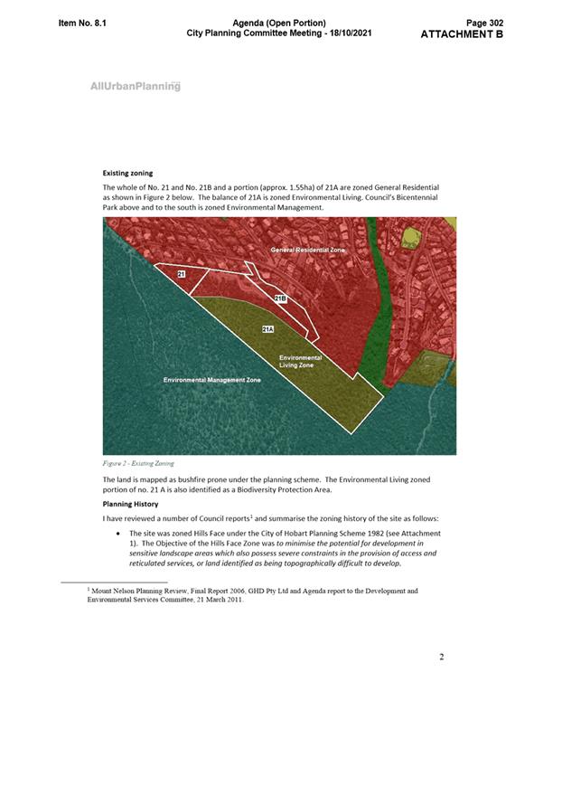
4.20. With regard to the HIPS 2015 overlays, the following apply to the site:
· all of the site is located within the Bushfire-Prone Area overlay under the Bushfire-Prone Areas Code;
· a portion of 21A and 21B Enterprise Road is located within the Landslide Hazard Area overlay under the Landslide Code;
· the land proposed to be rezoned is not within the Biodiversity Protection Area overlay under the Biodiversity Code, however the balance of 21A Enterprise Road is.
4.21. While this proposal is to amend the HIPS 2015, it is noted that the future Tasmanian Planning Scheme – Hobart is being progressed. The Tasmanian Planning Scheme – Hobart will be formed by the State Planning Provisions (SPPs) and LPS.
4.22. The density provisions for multiple dwellings and subdivision under the Acceptable Solutions of the SPPs will be:
|
Zone |
Multiple dwellings |
Subdivision |
|
General Residential |
325m² |
450m² |
|
Low Density Residential |
1,500m² |
1,500m² |
4.23. Additionally, under the Tasmanian Planning Scheme – Hobart:
· all of the site would be located within the Bushfire-Prone Area overlay under the Bushfire-Prone Areas Code;
· all of the site would be classified as a Priority Vegetation Area under the Natural Assets Code;
· a portion of 21A and 21B Enterprise Road would be located within the Landslide Hazard Area overlay under the Landslip Hazard Code;
· a small portion of 21B Enterprise Road would be located within the Flood-Prone Area overlay under the Flood-Prone Areas Hazard Code.
5. Proposal and Implementation
5.1. The proposal is to amend the HIPS 2015 zoning maps by rezoning the site from General Residential to Low Density Residential.
5.2. This report is based on information gathered from the proponent, landowners and Council officers.
5.3. Under the former provisions of the Land Use Planning and Approvals Act 1993 (the Act), planning scheme amendments must:
· seek to further the objectives set out in Schedule 1 of the Act;
· be in accordance with State Policies; and
· be consistent, as far as is practicable, with the Southern Tasmania Regional Land Use Strategy 2010-2035 (the regional strategy).
Provisions under the HIPS 2015 have also been considered.
5.4. In addition, the City of Hobart LPS is currently with the Tasmanian Planning Commission for consideration.
5.5. Given the timing of the LPS, the SPPs, which outline state-wide planning controls, have also been considered.
Justification – Petition
5.6. To support the proposal, the proponents engaged All Urban Planning Pty Ltd to provide a planning opinion on the matter. A copy of the planning opinion is available in the meeting agenda of 18 October 2021 at Attachment B.
5.7. All Urban Planning refers to Guideline No. 1 issued by the Tasmanian Planning Commission. This guideline provides a criteria for applying zoning under the planning schemes. The planning opinion notes:
5.7.1. General Residential Zone
In my assessment, application of the General Residential zoning does not align with Zone Application… the subject land that is bushfire prone, has a slope of approximately 23% and adjoins a Biodiversity Protection Area is highly constrained and not suitable for residential development at an urban density.
5.7.2. Low Density Residential Zone
In my assessment the Zone Application Guidelines for the Low Density Residential Zone show good alignment with the characteristics of the subject land as… it exists as three larger lots that are subject to the bushfire hazard overlay and is significantly constrained by the steep topography.
The land was identified in the MNPR [Mt Nelson Planning Review 2006] for lower density residential development below the more sensitive natural and landscape values. The intended application of the Low Density Residential Zone is by reason of the hazard and topographical considerations rather than landscape and aligns with this guidance.
… the bushfire hazard and topographical considerations indicate that the land is unsuited to development at a higher density. The road network between the sites and Churchill Avenue is narrow and constrained. These constraints also impede development of the subject land to higher densities.
In my opinion, the subject land that is highly constrained is not suitable for residential development at an urban density and the Low Density Residential Zone should be applied. (p. 5-6)
5.8. All Urban Planning noted that:
The residents are concerned that the characteristics of this steep, vegetated and bushfire prone land with constrained access mean that it is unsuited to development at the density allowed by the General Residential Zone... (p.1)
5.9. The petition does not provide specifics as to why the topography, vegetation and bushfire-prone nature of the land make it unsuitable for higher-density development, except with regard to landscape values.
Justification – Landowners
5.10. The landowners were contacted during the preparation of this report to allow comment on the proposal.
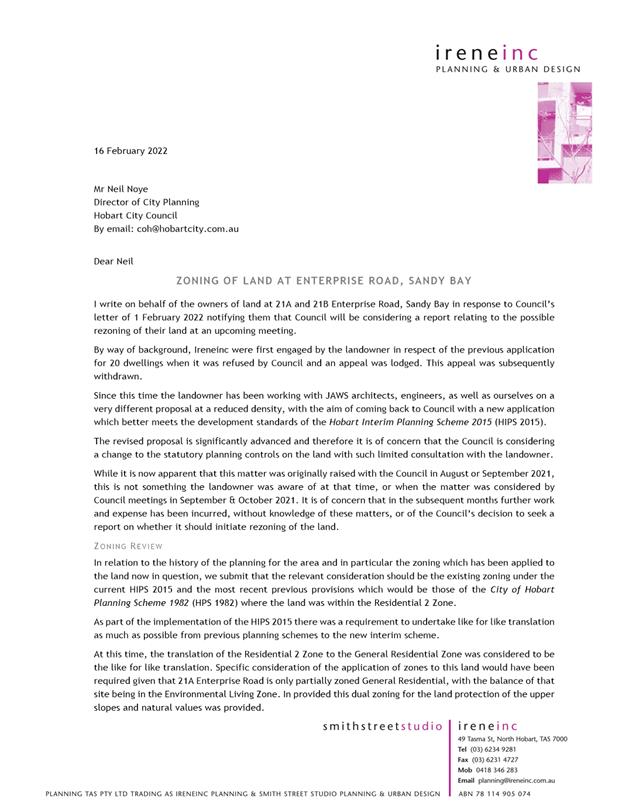
5.11. The landowners of 21A and 21B Enterprise Road engaged IreneInc Planning and Urban Design to prepare a submission on their behalf (Attachment C).
5.12. IreneInc considers that the current General Residential Zone is appropriate for the site and is consistent with the 2011 Residential 2 Zone under the HPS 1982. The submission notes:
… the translation of the Residential 2 Zone to the General Residential Zone was considered to be the like for like translation. Specific consideration of the application of zones to this land would have been
required given that 21A Enterprise Road is only partially zoned General Residential, with the balance of that site being in the Environmental Living Zone. In provided this dual zoning for the land protection of the upper slopes and natural values was provided.
The subject land is not significantly different from adjoining and nearby land which has been successfully developed as General Residential and therefore demonstrates that this land is not unreasonably constrained from development appropriate for the zone.
The subject land is located between the 175m and 225m contours, like other developed land adjoining in Enterprise Road and nearby in Nicholas Drive and Lindeth Court. These areas, including the directly adjoining area, are very like the subject land in their location, characteristics and slope, and are developed to residential densities typical of the area more generally at in the order of 1/867m2.
Regarding the relationship of the subject land to the Council’s Environmental Management Zoned reserve, it is noted that the neighbouring site at 21 Enterprise Road is already developed with a single dwelling and that the subject land owned by our client is separated by the large area of 21A Enterprise Road which is zoned Environmental Living. It is this are of land outside the General Residential Zoned are which forms an effective transition between the residential areas including those yet to be developed and the reserved
land beyond.
It is therefore considered that the combined provisions of the planning scheme including the zones and applicable codes, as they currently apply, are appropriate and sufficient to ensure that any future
development of the land responds to the constraints of the land and protects the amenity of the neighbouring properties. (p. 4-6)
Justification – Internal assessment
Consideration of submissions
5.13. In regards to topography, vegetation prior to development and bushfire rating, it is acknowledged that the lower portion of the site is not significantly different from adjoining and nearby land.
5.14. While the slope and bushfire-prone nature of the site will make development more difficult than land without these aspects, these are not considered to be highly constraining, other than the areas immediately adjacent to the Environmental Living and Environmental Management Zones.
5.15. Development of the land immediately adjacent the Environmental Living and Environmental Management Zones is likely to be constrained by the need for up-slope bushfire hazard management areas (HMAs).
5.16. Additionally, no highly significant biodiversity values, such as threatened vegetation communities, have been identified, and natural hazards are generally limited and able to be managed. However, it is acknowledged that all areas of bushland provide potential habitat for threatened species and support natural values.
5.17. It is noted that unlike the adjoining properties, the site does not have a road frontage. This causes issues with development at General Residential densities due to the narrow right of way access suitability for increased traffic volumes.
5.18. While it is acknowledged that the landowner of the site is currently preparing a development application at a lower density, this has not been lodged at the time of writing to determine its appropriateness for the site.
5.19. Of note, if the development application was to be lodged, the application and rezoning proposal, if initiated and certified, may run concurrently.
5.20. It is agreed with All Urban Planning that the site was identified as being suited to a low density of 1,500m² per dwelling under the Mt Nelson Planning Review 2006.
5.21. It is considered that this density is consistent with the Low Density Residential Zone.
Objectives of the Act
5.22. Part 1 of the objectives of the Act state:
The objectives of the resource management and planning system of Tasmania are –
a) To promote the sustainable development of natural and physical resources and the maintenance of ecological processes and genetic diversity; and
b) To provide for the fair, orderly and sustainable use and development of air, land and water; and
c) To encourage public involvement in resource management and planning; and
d) To facilitate economic development in accordance with the objectives set out in paragraphs (a), (b) and (c); and
e) To promote the sharing responsibility for resource management and planning between the different spheres of Government, the community and industry in the State.
5.23. It is considered that rezoning the site to Low Density Residential would further objectives (a), (b), (c) and (e) of Schedule 1 of the Act for the following reasons:
5.23.1. The impacts from stormwater on the site would decrease due to a lower density of development. This is further discussed below.
5.23.2. The larger lots associated with the Low Density Residential Zone may allow for residents to retain existing native vegetation or plant new vegetation once construction is complete. Revegetating the site may assist in erosion control to support the stormwater system.
5.23.3. The lower density would result in lower stormwater levels due to the reduction of hard surfaces associated with development.
5.23.4. The proposal to rezone the site has come from a petition within the community of Hobart.
State Policies
5.24. The only state policy relevant to the site is the State Policy on Water Quality Management 1997.
5.25. The HIPS 2015 includes provisions that ensure use and development is undertaken in accordance with the policy. This is included in E7.0 Stormwater Management Code of HIPS 2015.
5.26. The matter was referred to Council’s City Amenity division who have assessed the stormwater impacts from development associated with the General Residential and Low Density Residential Zones.
5.27. The officers note that:
5.27.1. 21 Enterprise Road is not serviced by public infrastructure. It has drainage rights over the private table drain along the right of way that leads to the Enterprise Road drainage system.
5.27.2. 21A Enterprise Road is partially able to be serviced by the Enterprise Road drainage system. Most of the site drains to the cut-off drain which discharges over a landslip prone area towards a minor tributary.
5.27.3. 21B Enterprise Road could potentially detain the runoff from a 1 in 20 year rain event (5% AEP), though flows from rain events greater than that would be problematic for the catchment downstream. Sediment flows from this site are difficult to manage.
5.27.4. From a planning perspective, it is also noted that the SPPs do not include a stormwater code. Due to this, it is considered that there is inadequate provisions under the future Tasmanian Planning Scheme – Hobart to manage the stormwater risks of large events at the development application stage.
5.27.5. Decreasing the density permitted on site may reduce some stormwater impacts associated with future development.
5.27.6. It is considered that rezoning the site to Low Density Residential would be in accordance with the State Policy on Water Quality Management 1997.
Regional strategy
5.28. It is considered that rezoning the site to Low Density Residential would be consistent, as far as is practicable, with the regional strategy for the following reasons.
5.29. Policy SRD 1.5 states:
Encourage land zoned General Residential to be developed at a minimum of 15 dwellings per hectare (net density).
5.29.1. In 2021, a development application for 20 multiple dwellings was refused by Council at 21B Enterprise Road, Sandy Bay (PLN-20-740). This lot has a site area of approximately 8,030m².
5.29.2. Council determined that the local road network cannot support the traffic increase associated with the General Residential Zone density.
5.29.3. It is considered that the local road network can support traffic increase associated with Low Density Residential density. As such, rezoning the site to Low Density Residential is consistent with Policy SRD 1.5 of the regional strategy.
5.30. Policy SRD 1.6 states:
Utilise the Low Density Residential Zone only where it is necessary to manage land constraints in settlements or to acknowledge existing areas.
5.30.1. The land is not considered to be significantly constrained due to its slope, vegetation and bushfire attack level rating in itself. However, access to the site, excavation requirements and impacts on downstream drainage is considered a land constraint and has implications for future development of the site.
5.30.2. Developing the site at the General Residential Zone density requires significant earthworks due to the gradient of the site.
5.30.3. The geology of the site is Jurassic dolerite. This landform can be difficult to excavate and may require heavy machinery to prepare the site for development. The landform has been successfully excavated on surrounding properties, however, this is dependent on the degree of weathering and would require further investigation.
5.30.4. A differing factor with this site in comparison to the surrounding area is getting machinery to site. It has already been encountered and recognised by developers who are starting work on an approved subdivision at Enterprise Road and Edith Avenue. The request required bringing large excavation machinery across the top of the Mount Nelson Road Environmental Management area. This was requested (and refused) after the developer recognised the risk to the road structure and possible adjoining property’s along Edith Avenue and Enterprise Road.
5.30.5. It is considered that the abovementioned constraints justify the application of the Low Density Residential Zone on the site. As such, rezoning the site to Low Density Residential is consistent with Policy SRD 1.6 of the regional strategy.
HIPS 2015 – Bushfire-Prone Areas
5.31. As mentioned, the whole site is located within the bushfire-prone areas overlay under the HIPS 2015. It will also transition to the Tasmanian Planning Scheme – Hobart.
5.32. Council’s Environmental Planning division provided comment on the matter. They noted that bushfire is the only significant natural hazard identified for the site.
5.33. With regard to developing to bushfire standards, the advice provided by the Environmental Planning division is summarised below:
5.33.1. The main constraint associated with being bushfire-prone is the need to provide fuel-reduced hazard management areas (HMAs) for each new dwelling or each new lot.
5.33.2. Higher density development of the land as allowed under the General Residential Zone would necessitate the encroachment of HMAs into the adjacent Environmental Living or Environmental Management zones, and the Biodiversity Protection Area overlay.
5.33.3. It is likely that low-density development of the land as allowed under the Low Density Residential Zone can contain HMAs on the land without encroachment into the Environmental Living or Environmental Management Zones and the Biodiversity Protection Area overlay.
5.33.4. The establishment of HMAs within the Environmental Living Zone would be problematic and may not be approved. As a result, it's unlikely that all of the land within the General Residential Zone could be developed at the density permitted in that zone.
5.33.5. It is likely that the land could be developed at densities higher than those permitted in the Low Density Residential Zone without HMAs encroaching into the adjoining land zoned Environmental Living.
5.33.6. For example, if just the land at 21B Enterprise Road is considered (8,030m²), 24 dwellings would be permitted under the density standards for the General Residential Zone.
5.33.7. Under BAL-19 and BAL-29 construction, the bushfire HMA could be largely contained within the lot and adjoining General Residential Zone on 21A Enterprise Road. However, due to the likely location of the dwellings, an encroachment into the Environmental Living Zone and Biodiversity Protection Area overlay would also occur.
5.33.8. The lot may not be of adequate size and shape to support 24 dwellings, however from a bushfire perspective it may support approximately 18 dwellings without the need to have bushfire HMAs encroaching into the Environmental Management Zone or Environmental Living Zone, and Biodiversity Protection Area overlay.
5.33.9. By comparison, five dwellings would be permitted under the Low Density Residential Zone. The approximate bushfire HMA for a five dwelling development if the dwellings are spread out across the lot slightly extends into 21A Enterprise Road. This is based on construction to BAL-19. The HMA could be largely contained to 21B Enterprise Road if BAL-29 construction was adopted, however there would still be a small degree of encroachment onto the adjoining lot.
5.33.10. If the lot was developed as a single row of 10 dwellings, the size of the HMA would be no greater than five dwellings spread across the site, and the amount of vegetation requiring clearing would be similar. From an environmental planning perspective, an increased dwelling yield for the same degree of vegetation impact is a preferable outcome.
5.33.11. With regard to the other two lots, the bushfire HMAs are much more acute as these border or include land in the Environmental Management Zone, Environmental Living Zone and Biodiversity Protection Area overlay. It would be extremely difficult to develop this land at the densities permitted in the General Residential Zone without bushfire HMAs requiring land within the Environmental Management, Environmental Living Zones and Biodiversity Protection Area overlay.
5.33.12. In particular, due to the narrow width of the land at 21A Enterprise Road within the General Residential Zone, it would be practically impossible to develop housing in this section without bushfire HMAs extending into the Environmental Living Zone and Biodiversity Protection Area. This lot is unlikely to support 49 dwellings permitted under the General Residential Zone and the associated bushfire HMAs. The lot could support more than the 10 dwellings that would be permitted if it was zoned Low Density Residential, meaning a reduced lot yield for a similar vegetation impact.
HIPS 2015 – Roads
5.34. It was demonstrated in the assessment of application PLN-20-740 that 20 multiple dwellings results in overdevelopment of 21A Enterprise Road, as it significantly impacts the local road network.
5.35. Council’s Development Engineering division provided comment on the matter. They note that there are concerns with large single or many small developments in this area. Particularly:
5.35.1. The capacity of the lower road networks ability to absorb increased traffic produced from any development is problematic, particularly near Birngana Street and Niree Heights.
5.35.2. The ability of the lower road network, including Birngana Road, Niree Heights, Beddome Street and Edith Avenue, to sustain heavy vehicle movements required for development without incurring significant damage.
5.35.3. The potential risk to neighbouring properties from large development excavation.
5.35.4. The officers note that rezoning the site to Low Density Residential may reduce some of these concerns.
HIPS 2015 - Stormwater
5.36. In addition to the comments made under the State Policies assessment, Council’s City Amenity division advised the following.
5.36.1. The current and future stormwater runoff from a development like PLN-20-740, and Enterprise Road drainage, all end up in Maning Rivulet.
5.36.2. The lower reaches of Maning Rivulet have been modelled as having limited receiving capacity in a 1 in 100 rain event (1% AEP) under current development conditions.
5.36.3. The impact of runoff from development in a rain event such as 1 in 100 year event on the supper sections of Maning Rivulet may be somewhat mitigated by the ‘detention’ ponding behind Churchill Avenue, though this road embankment was not designed or built as a dam.
5.36.4. E6.0 Stormwater Management Code of the HIPS 2015 requires on-site detention; however, runoff would increase in post-development compared to pre-development, particularly in longer duration rain events.
5.36.5. Future development design must also manage runoff from bushland above.
Summary of findings
5.37. As identified above, the proposal to rezone the site from General Residential to Low Density Residential would not address the vegetation and bushfire concerns raised in the petition.
5.38. However, as part of this analysis it has been highlighted that the proposal would improve the impacts from development on stormwater and traffic volumes, which have a greater impact on the surrounding area.
5.39. While there are planning merits in retaining the existing zoning, it is considered that the benefits gained by rezoning the site to Low Density Residential to lower the impacts of stormwater and traffic caused by development, outweighs the benefits of developing the site at a General Residential Zone density.
5.40. Council’s Environmental Planning division advised that if the recommendation is to rezone the site to Low Density Residential, the Biodiversity Protection Area overlay should also apply to the site.
5.41. The reasons for this is to further protect the mature vegetation on the site and retain consistency in the area. It is considered that there is merit in applying the Biodiversity Protection Area overlay to the site.
5.42. It is therefore recommended that the site be rezoned from General Residential to Low Density Residential and the Biodiversity Protection Area overlay under the Biodiversity Code be applied to the site, with the exception of the right of ways.
6. Strategic Planning and Policy Considerations
6.1. The proposed amendment is consistent with the objectives of the Capital City Strategy Plan 2019-29, in particular with the following outcomes:
6.1.1. Hobart keeps a strong sense of place and identity, even as the city changes;
6.1.2. Hobart’s cityscape reflects the heritage, culture and natural environment that make it special;
6.1.3. In City decision-making, we consider how different aspects of Hobart life connect and contribute to sense of place;
6.1.4. The natural environment is part of the city and biodiversity is preserved, secure and flourishing;
6.1.5. Development enhances Hobart’s unique identify, human scale and built heritage;
6.1.6. Community involvement and an understanding of future needs help guide changes to Hobart’s built environment.
7. Financial Implications
7.1. Funding Source and Impact on Current Year Operating Result
7.1.1. None
7.2. Impact on Future Years’ Financial Result
7.2.1. None
7.3. Asset Related Implications
7.3.1. None
8. Legal, Risk and Legislative Considerations
8.1. Under section 32 of the Act, planning scheme amendments must:
· seek to further the objectives set out in Schedule 1 of the Act;
· be in accordance with State Policies;
· as far as practicable, avoid the potential for land use conflicts with use and development under an adjoining local authority’s planning scheme; and
· be consistent, as far as is practicable, with the Southern Tasmania Regional Land Use Strategy 2010-2035 (the regional strategy).
8.2. As identified in section 5.0, the proposal is considered to meet these requirements.
8.3. Additionally, as the site does not adjoin land under the planning scheme of an adjacent area, no impact from the proposal will occur.
9. Environmental Considerations
9.1. The draft amendment has been considered in terms of its impacts on the environmental values of the site. It is evident that developing the site even under a Low Density Residential density will have environmental impacts on the site.
9.2. Council’s Environmental Planning division generally support zonings that limit development in areas of bushland to conserve natural values of any significant.
9.3. They note that if impacts to native vegetation are to occur, it would be preferable to see more housing being provided for the same impact rather than less.
9.4. They further advise that if the land is proposed to be rezoned to Low Density Residential, they recommend proposing an extension of the Biodiversity Protection Area overlay over the site for consistency with other land in the zone.
10. Social and Customer Considerations
10.1. The proposal is not considered to have any negative impact on social inclusion.
11. Marketing and Media
11.1. There are no marketing or branding implications of this draft amendment.
12. Community and Stakeholder Engagement
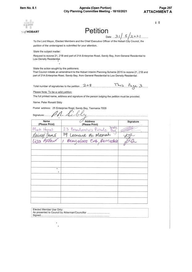
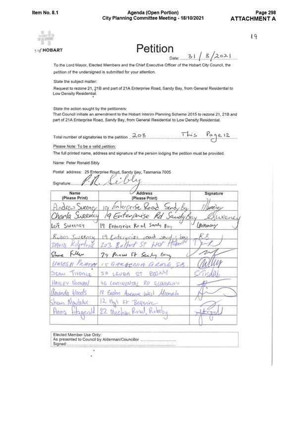
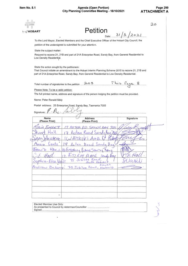
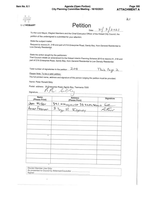
12.1. This report has been written in response to a petition tabled at Council on 6 September 2021. The petition contained 208 signatures from nearby residents of the site.
12.2. The landowners of the site were contacted during the preparation of this report and invited to make comment on the matter. A submission was received from the landowners of 21A and 21B Enterprise Road.
12.3. If the draft amendment is initiated and certified, the documents will be publically exhibited for a period of 28 days. During this time representations can be made to Council.
12.4. Following the closure of the exhibition period, a report will be prepared in response to the representations received for Council to consider. This report will be forwarded to the Tasmanian Planning Commission (the Commission) and form part of the draft amendment documentation.
12.5. If considered appropriate, hearings will be held by the Commission to discuss the representations and planning merit of rezoning the site. Following this, the Commission will make its decision.
12.6. In summary, there a several points during the draft amendment process to which the public may make comment.
13. Delegation
13.1. Delegation rests with the Council.
As signatory to this report, I certify that, pursuant to Section 55(1) of the Local Government Act 1993, I hold no interest, as referred to in Section 49 of the Local Government Act 1993, in matters contained in this report.
|
Karen Abey Acting Director City Life |
|
Date: 8 March 2022
File Reference: F22/7522; PSA-21-4
Attachment a: Rezoning
Plan ⇩ ![]()
Attachment
b: Meeting
agenda and petition, 18 October 2021 ⇩ ![]()
Attachment
c: Landowner
submission ⇩ ![]()
Attachment
d: Instrument
of certification ⇩ ![]()
|
Item No. 7.1.3 |
Agenda (Open Portion) City Planning Committee Meeting - 21/3/2022 |
Page 190 ATTACHMENT a |
|
Agenda (Open Portion) City Planning Committee Meeting - 21/3/2022 |
Page 222 ATTACHMENT b |

|
Item No. 7.1.3 |
Agenda (Open Portion) City Planning Committee Meeting - 21/3/2022 |
Page 227 ATTACHMENT c |
|
Agenda (Open Portion) City Planning Committee Meeting - 21/3/2022 |
Page 228 ATTACHMENT d |
|
Item No. 7.1.4 |
Agenda (Open Portion) City Planning Committee Meeting |
Page 229 |
|
|
21/3/2022 |
|
7.1.4 Short Stay Accommodation - Proposed Amendments to the Hobart Interim Planning Scheme
Report of the Manager City Futures and the Acting Director City Life of 16 March 2022 and attachments.
Delegation: Council
|
Item No. 7.1.4 |
Agenda (Open Portion) City Planning Committee Meeting |
Page 239 |
|
|
21/3/2022 |
|
REPORT TITLE: Short Stay Accommodation - Proposed Amendments to the Hobart Interim Planning Scheme
REPORT PROVIDED BY: Manager City Futures
Acting Director City Life
1. Report Purpose and Community Benefit
1.1. This report has been prepared in response to Council’s resolution (in part) of 23 August 2021 that:
Council pursue inserting one or more specific area plans into the Hobart Local Provisions Schedule that prohibit entire home short stay accommodation use (SSA) (excluding for ‘secondary residences’).
1.2. The report will benefit the community by proposing a planning scheme amendment that may help to mitigate negative impacts of short stay Visitor Accommodation.
2. Report Summary
2.1. The proposal is to amend the Use Table in each of the General Residential Zone, the Inner Residential Zone, and the Low Density Residential Zone to restrict the use ‘Visitor Accommodation’.
2.2. The amendment to each Use Table is to add a specific qualification for Visitor Accommodation.
2.3. The qualification has the effect of restricting the use of Visitor Accommodation if the use is wholly for Visitor Accommodation within:
a) a single dwelling; or
b) a dwelling
and the single dwelling or dwelling is not an ancillary dwelling.
2.4. The proposed amendment is provided in Attachment A.
|
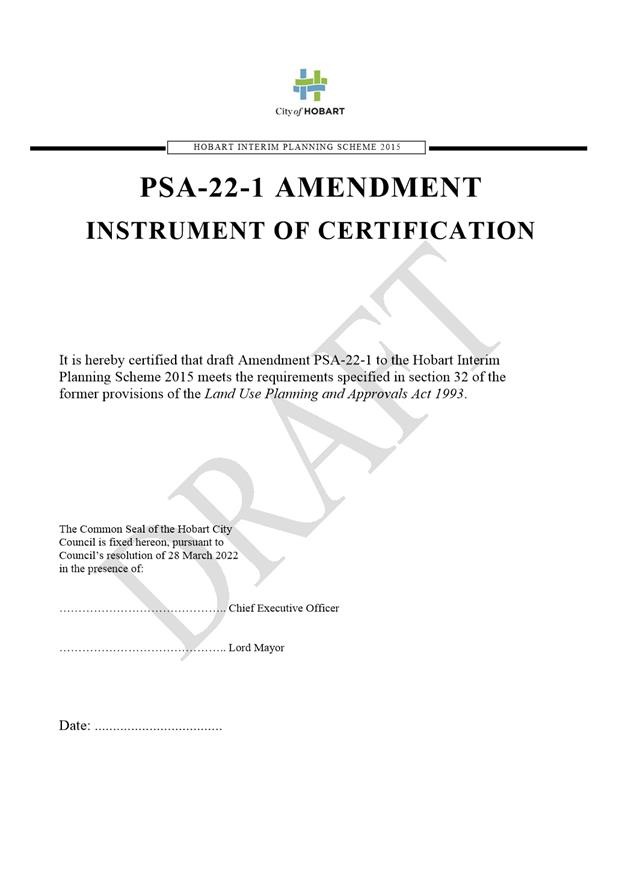
That: 1. Council endorse the draft amendment to the Use Table in each of the General Residential Zone, the Inner Residential Zone, and the Low Density Residential Zone for inclusion in the Hobart Interim Planning Scheme 2015 to restrict entire home Visitor Accommodation use (excluding for ‘ancillary dwellings’) in specified zones of the Hobart Interim Planning Scheme 2015 as detailed in Attachment A. 2. Under section 35 of the former provisions of the Land Use Planning and Approvals Act 1993, Council certify that amendment PSA-22-1 to the Hobart Interim Planning Scheme 2015 meets the requirements of section 32 of the former provisions of the Land Use Planning and Approvals Act 1993 and authorise the Chief Executive Officer and Lord Mayor to sign the Instrument of Certification (Attachment A). 3. Under section 38 of the former provisions of the Land Use Planning and Approvals Act 1993, the Council place the amendment to the Hobart Interim Planning Scheme on public exhibition for a 28 day period.
|
4. Background
4.1. At its meeting on 17 December 2020, Council resolved inter alia that:
A report be prepared on the possible amendments, and their merits, to the planning regulations to more appropriately control the number of private properties being converted to whole home short stay accommodation.
4.2. At its meeting on 9 February 2021, the Council resolved inter alia that:
(a) A report be prepared on the possible amendments, their merits and potential consequences, to the planning regulations to implement the following recommendations made in the UTAS Report titled: Regulating Short-Stay Accommodation in Tasmania: Issues to consider and options for reform:
Recommendation 3: That the Tasmanian Government amend the current planning scheme to allow consideration of housing market conditions when making planning decisions.
Recommendation 4: That the current planning scheme include provisions so that it can respond to community-level housing needs in a timely manner.
(b) Advice be prepared as to the merits and potential consequences of endorsing Recommendation 5 of the same report
Recommendation 5: That the Tasmanian Government establish a Housing Supply Forecasting Council to collect and analyse housing supply and demand drivers, including the impact of the SSA sector, and provide policy recommendations.
4.3. At its meeting on 23 August 2021, Council resolved as follows:
That:
1. Council pursue inserting one or more specific area plans into the Hobart Local Provisions Schedule that prohibit entire home short stay accommodation use (excluding for ‘secondary residences’).
2. Council advocate to the Minister for Planning to issue a planning directive that immediately prohibits new permits for entire home short stay accommodation within the Hobart Local Government Area;
3. Council advocate for statewide regulations, similar to those in New South Wales, that enable councils to make decisions about properties within their local government area; and
4. Council advocate to the Tasmanian Government to form a ‘Housing Supply Forecasting Council’ in line with Recommendation 5 of the report Regulating Short-Stay Accommodation in Tasmania: Issues to consider and options for reform.
4.4. As per the resolution, the Lord Mayor, wrote to the Minister for Planning (Minister) on 12 November 2021 (Attachment B). The letter outlined the concerns of Council that the current Planning Directive 6 (PD6) allows for Visitor Accommodation in existing buildings of up to 200m2 (unless part of a strata scheme with existing residential use) as a permitted use in most residential zones except those within Battery Point.
4.5. Furthermore, noting that PD6 precludes individual planning authorities from inserting more restrictive SSA provisions into the current planning instruments (the Hobart Interim Planning Scheme 2015 (HIPS) and the Sullivans Cove Planning Scheme 1997 (SCPS).
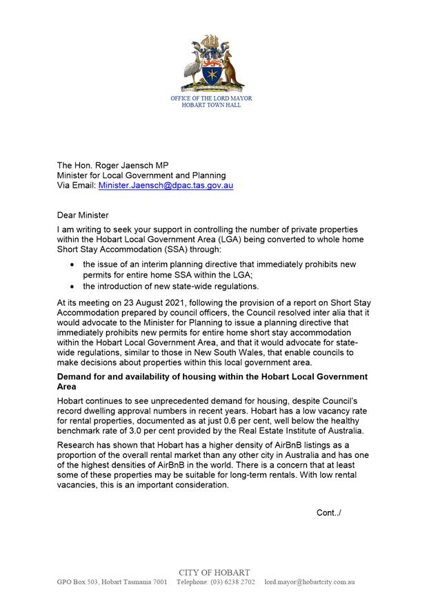
4.6. The Lord Mayor requested that the Minister issue a prohibition for new entire home SSA permits within the Hobart Local Government Area (LGA), which might be achieved by way of an interim planning directive, with immediate effect, issued under the Land Use Planning and Approvals Act 1993. This would allow for new short stay accommodation restrictions to be in force in the Hobart LGA significantly more quickly than would be possible through an amendment of the Hobart Local Provisions Schedule (LPS)
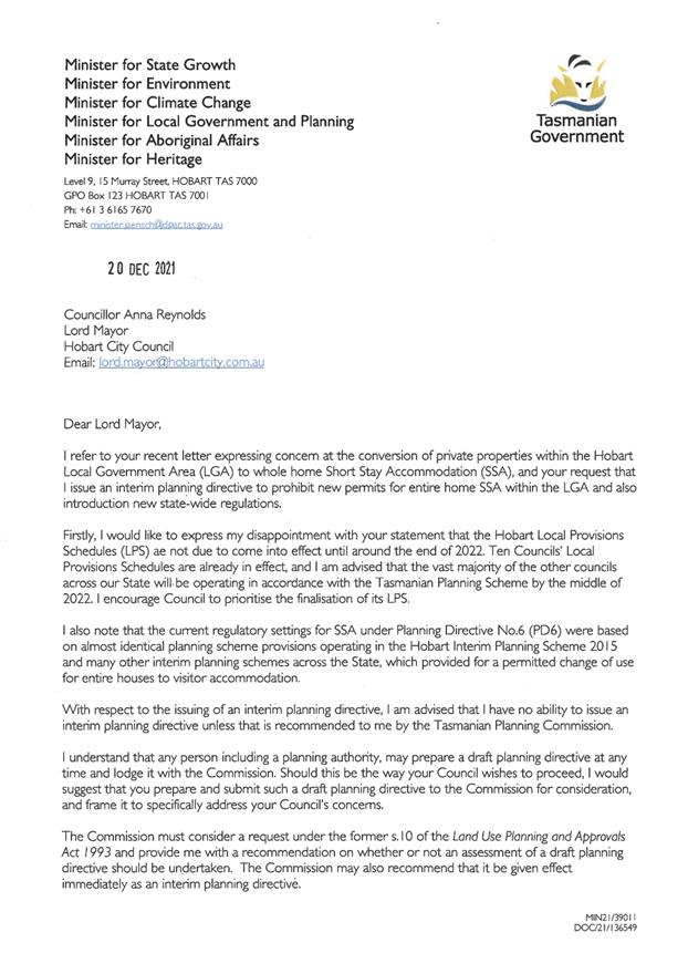
4.7. In response to the above request, the Minister advised via letter on 20 December 2021 (Attachment C) that ‘..I have no ability to issue an interim planning directive unless it is recommended to me by the Tasmanian Planning Commission.’
4.8. Further the Minister advised that:
4.8.1. ‘..it is also possible for your Council to seek an amendment to its Interim Planning Scheme and, if supported by the Commission, a Planning Purposes Notice can be issued to ‘relieve’ the Scheme from the mandatory application of PD6.’
4.8.2. ‘This has occurred on a number of occasions in relation to other planning directives. I understand that such an amendment to the interim planning scheme would be able to be transitioned through to the draft Hobart LPS.’
5. Proposal and Implementation
5.1. The proposal is to amend the Hobart Interim Planning Scheme 2015 (the interim planning scheme) by inserting a new qualification for ‘Visitor accommodation’ in the Use Table in each of the General Residential Zone, the Inner Residential Zone, and the Low Density Residential Zone.
5.2. While Council’s previous resolution referred to introducing one or more specific area plans, after further consideration of the potential mechanisms in the interim planning scheme, it is considered that adding a specific qualification for ‘Visitor accommodation’ to various residential zones is the most effective way to achieve the policy intent.
5.3. The qualification is to restrict the use of ‘Visitor accommodation’ if the use is wholly within:
a) a single dwelling; or
b) a dwelling
and the single dwelling or dwelling is not an ancillary dwelling
5.4. A ‘dwelling’ is defined in the interim planning scheme as:
‘means a building, or part of a building, used as a self contained residence and which includes food preparation facilities, a bath or shower, laundry facilities, a toilet and sink, and any outbuilding and works normally forming part of a dwelling.’
5.5. A ‘single dwelling’ is defined in the interim planning scheme as:
‘means a dwelling on a lot on which no other dwelling is situated, or a dwelling and an ancillary dwelling on a lot on which no other dwelling is situated.’
5.6. Rather than use ‘secondary dwelling’, a term used in the State Planning Provisions (SPPs) and the LPS but not the interim planning scheme, the most relevant term in the interim scheme is ‘ancillary dwelling’ and defined as:
‘means an additional dwelling:
(a) with a floor area not greater than 60m2;
(b) that is appurtenant to a single dwelling; and
(c) that shares with that single dwelling access and parking, and water, sewerage, gas, electricity and telecommunications connections and meters.’
5.7. The Hobart LPS is currently with the Tasmanian Planning Commission for consideration.
5.8. It is expected that the Hobart LPS will be finalised towards the end of 2022. When the Hobart LPS comes into effect, transitional arrangements means the term ‘secondary residence’ can replace ‘ancillary dwelling’.
5.9. It is noted that the change to the Use Tables will only impact new uses. It is not possible to remove existing valid permits or operations.
6. Strategic Planning and Policy Considerations
6.1. The proposed amendment is consistent with the objectives of the Capital City Strategy Plan 2019-29, in particular with the following outcomes:
6.1.1. Hobart keeps a strong sense of place and identity, even as the city changes.
6.1.2. Hobart’s cityscape reflects the heritage, culture and natural environment that make it special.
6.1.3. In City decision-making, we consider how different aspects of Hobart life connect and contribute to sense of place.
6.1.4. Hobart is a place where diversity is celebrated and everyone can belong, and where people have opportunities to learn about one another and participate in city life.
6.1.5. Hobart’s economy is strong diverse and resilient.
6.1.6. Hobart has a diverse supply of housing and affordable homes.
6.1.7. Development enhances Hobart’s unique identity, human scale and built heritage.
6.1.8. Community involvement and an understanding of future needs help guide changes to Hobart’s built environment.
6.1.9. Hobart is a city of best practice, ethical governance and transparent decision-making.
7. Financial Implications
7.1. Funding Source and Impact on Current Year Operating Result
7.1.1. None
7.2. Impact on Future Years’ Financial Result
7.2.1. Resources have been diverted from other strategic planning activities to prepare and facilitate this amendment.
7.3. Asset Related Implications
7.3.1. None
8. Legal, Risk and Legislative Considerations
8.1. Under the former provisions of the Land Use Planning and Approvals Act 1993 (the Act), planning scheme amendments must:
· seek to further the objectives set out in Schedule 1 of the Act;
· be prepared in accordance with State Policies; and
· be consistent, as far as is practicable, with the Southern Tasmania Regional Land Use Strategy 2010-2035 (the regional strategy).
8.2. The Objectives of the Act require use and development to occur in a fair, orderly and sustainable manner and for the planning process to facilitate economic development in accordance with other Schedule 1 objectives.
Objectives of the Act
8.3. Part 1 of the objectives of the Act state:
The objectives of the resource management and planning system of Tasmania are –
a) To promote the sustainable development of natural and physical resources and the maintenance of ecological processes and genetic diversity; and
b) To provide for the fair, orderly and sustainable use and development of air, land and water; and
c) To encourage public involvement in resource management and planning; and
d) To facilitate economic development in accordance with the objectives set out in paragraphs (a), (b) and (c); and
e) To promote the sharing responsibility for resource management and planning between the different spheres of Government, the community and industry in the State.
8.4. It is considered that changing the Use Table would further objectives (a), (b), (c) and (e) of Schedule 1 of the Act for the following reasons:
8.4.1. The increased availability of dwellings for occupation by permanent residents rather than sporadic occupation, ensuring more efficient use of land and resources.
8.4.2. The increased availability of properties in the long-term rental market.
8.4.3. More visitors using hotel or serviced accommodation is likely to result in greater economic benefit locally, as these businesses will require additional employees, which in turn will result in flow on spending from the increased levels of employment of local residents thereby benefitting more local businesses.
8.4.4. The benefits to local business and communities from having additional permanent residents in local suburbs, thereby benefiting the sustainability of local businesses and smoothing the flow of funds into the local economy.
8.4.5. The proposal was initiated following concerns raised by Council, the community and organisations such as Shelter Tasmania.
8.5. It is considered that the proposed amendment is consistent with the State Policy on Water Quality Management 1997 and the State Coastal Policy 1996. The State Policy for the Protection of Agricultural Land 2009 is not relevant and neither are any National Environmental Protection Measures.
8.6. It is considered that the proposal is, as far as is practical, consistent with relevant strategic directions and regional policies of the Southern Tasmania Regional Land Use Strategy 2010–2035 (STRLUS), as it will facilitate the retention of dwellings for residential use, reduce the need for development of greenfield land and result in a greater proportion of the population living in proximity to services and employment opportunities.
8.7. In particular, the proposal is consistent with STRLUS State Policy SRD 2 ‘Manage residential growth for Greater Hobart on a whole of settlement basis and in a manner that balances the needs for greater sustainability, housing choice and affordability’.
8.8. Section 32(e) of the Act requires that planning scheme amendments must, as far as practicable, avoid the potential for land use conflicts with use and development permissible under the planning scheme applying to the adjacent area. As the amendment does not alter the underlying zoning of land adjoining land zoned under another different planning scheme it is considered that this requirement is met.
9. Environmental Considerations
9.1. The draft amendment has been considered in terms of its impacts on the environmental values of the site.
9.2. SSA has an impact on the environment to the extent that it affects the location and distribution of tourism accommodation infrastructure and restricts the use of dwellings by permanent residents in more sustainable locations.
9.3. There is increasing evidence that the use of whole dwellings for SSA has an effect on housing in Hobart. Long-term renters and home buyers are channelled towards housing in outlying suburbs and neighbouring Local Government areas, potentially leading to the development of greenfield land, rather than renewal of existing urban areas. Accordingly, this can lead to increased levels of car use and associated traffic congestion, and increased emissions.
9.4. At the same time, SSA uses existing housing stock to support tourists, which may limit the need for hotel developments (and cause under occupancy of hotel accommodation) but consequently, simultaneously, increase the need for new housing development. All new housing development has an environmental impact.
10. Social and Customer Considerations
10.1. The proposed amendment is not considered to have any negative impact on social inclusion and is likely to result in some positive social impacts.
10.2. Restricting the use of whole dwellings for short stay visitor accommodation is likely to result in more dwellings being available in the long-term rental market.
10.3. More dwellings in the long-term rental market will facilitate increased access to housing for more people, in proximity to jobs and services.
10.4. It should be noted that many factors influence housing supply and affordability, not only short stay visitor accommodation; however, people already living in a more vulnerable situation without security of tenure (renting rather than owning) are in a more precarious position, as decreases in supply normally result in rent increases.
10.5. At the same time, regulating short stay visitor accommodation will have an impact on some prospective hosts, as (in the specified zones) they will no longer be able to purchase new properties or use a whole dwelling or single dwelling, for the sole purpose of providing short stay visitor accommodation.
11. Marketing and Media
11.1. There are no marketing or branding implications of this proposed amendment.
12. Community and Stakeholder Engagement
12.1. This report has been written in response to the Council resolution on 23 August 2021.
12.2. If the draft amendment is initiated and certified, amendment will be publicly exhibited for a period of 28 days. During this time, representations can be made to Council.
12.3. Following the closure of the exhibition period, a report will be prepared in response to the representations received for Council to consider. This report will be forwarded to the Tasmanian Planning Commission (the Commission) and form part of the draft amendment documentation.
12.4. If considered appropriate, hearings will be held by the Commission to discuss the representations and planning merit of rezoning the site. Following this, the Commission will make its decision.
12.5. In summary, there a several stages during the draft amendment process at which, the public may make comment.
13. Delegation
13.1. Delegation rests with the Council.
As signatory to this report, I certify that, pursuant to Section 55(1) of the Local Government Act 1993, I hold no interest, as referred to in Section 49 of the Local Government Act 1993, in matters contained in this report.
|
Sandra Hogue Manager City Futures |
Karen Abey Acting Director City Life |
Date: 16 March 2022
File Reference: F22/20739
Attachment a: Attachment
A - Instrument of certification planning scheme amendment 22-1 ⇩ ![]()
Attachment
b: Attachment
B - Letter to Minister Jaensch MP - Short Stay Accommodation in Hobart ⇩ ![]()
Attachment
c: Attachment
C - Letter frrom Minister Jaensch to Lord Mayor Councillor Anna M Reynolds -
Short Stay Accommodation in Hobart ⇩ ![]()
|
Item No. 7.1.4 |
Agenda (Open Portion) City Planning Committee Meeting - 21/3/2022 |
Page 241 ATTACHMENT a |
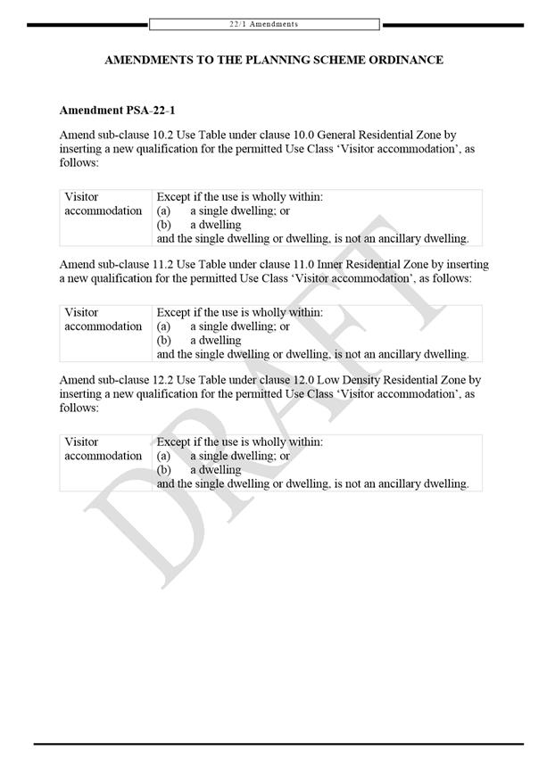
|
Agenda (Open Portion) City Planning Committee Meeting - 21/3/2022 |
Page 244 ATTACHMENT b |
|
Agenda (Open Portion) City Planning Committee Meeting - 21/3/2022 |
Page 247 ATTACHMENT c |
|
Agenda (Open Portion) City Planning Committee Meeting |
Page 248 |
|
|
|
21/3/2022 |
|
8. Reports
8.1 Monthly Building Statistics - 1 February - 28 February 2022
Memorandum of the Acting Director City Life of 16 March 2022 and attachments.
Delegation: Council
|
Item No. 8.1 |
Agenda (Open Portion) City Planning Committee Meeting |
Page 250 |
|
|
21/3/2022 |
|
Memorandum: City Planning Committee
Monthly Building Statistics - 1 February - 28 February 2022
Attached is the Building Permit Statistics for the period 1 February - 28 February 2022.
|
That:
The Director City Life reports:
Building Statistical Report:
During the period 1 February 2022 to 28 February 2022, 53 permits were issued to the value of $17,069,738 which included:
(i) 32 for extensions/alterations to dwellings to the value of $7,623,705;
(ii) 6 new dwellings to the value of $3,166,790;
(iii) 0 new multiple dwellings to the value of $ Nil; and
(iv) No major projects.
During the period 1 February 2021 to 28 February 2021, 46 permits were issued to the value of $17,062,645 which included:
(i) 32 for extensions/alterations to dwellings to the value of $8,743,350;
(ii) 5 new dwellings to the value of $2,128,149;
(iii) 2 new multiple dwellings to the value of $565,000 and
(iv) 2 major projects:
(a) 431 Elizabeth Street, North Hobart - New Commercial Building - $3,950,000;
(b) 59 Sandy Bay Road, Sandy Bay - New Commercial Building - $3,000,000.
In the twelve months ending February 2022, 607 permits were issued to the value of $261,432,979; and
In the twelve months ending February 2021, 655 permits were issued to the value of $188,166,806.
|
As signatory to this report, I certify that, pursuant to Section 55(1) of the Local Government Act 1993, I hold no interest, as referred to in Section 49 of the Local Government Act 1993, in matters contained in this report.
|
Karen Abey ACTING Director City Life |
|
Date: 16 March 2022
File Reference: F22/19475
Attachment a: Building
Permits Issued Accumulative Monthly Totals Bar Graph - Feb 2022 ⇩ ![]()
Attachment
b: Building
Permits Value Accumulative Monthly Bar Graph - Feb 2022
⇩ ![]()
Attachment
c: Monthly
Building Permits Issued Line Graph - Feb 2022 ⇩ ![]()
Attachment
d: Value
of Monthly Building Permits Issued Line Graph - Feb 2022 ⇩ ![]()
|
Item No. 8.1 |
Agenda (Open Portion) City Planning Committee Meeting - 21/3/2022 |
Page 251 ATTACHMENT a |
|
Item No. 8.1 |
Agenda (Open Portion) City Planning Committee Meeting - 21/3/2022 |
Page 252 ATTACHMENT b |
|
Item No. 8.1 |
Agenda (Open Portion) City Planning Committee Meeting - 21/3/2022 |
Page 253 ATTACHMENT c |
|
Item No. 8.1 |
Agenda (Open Portion) City Planning Committee Meeting - 21/3/2022 |
Page 254 ATTACHMENT d |
|
Item No. 8.2 |
Agenda (Open Portion) City Planning Committee Meeting |
Page 255 |
|
|
21/3/2022 |
|
8.2 Monthly Planning Statistics - 1 February - 28 February 2022
Memorandum of the Acting Director City Life of 16 March 2022 and attachments.
Delegation: Council
|
Item No. 8.2 |
Agenda (Open Portion) City Planning Committee Meeting |
Page 257 |
|
|
21/3/2022 |
|

Memorandum: City Planning Committee
Monthly Planning Statistics - 1 February - 28 February 2022
Attached is the Planning Permit statistics for the period 1 February 2022 – 28 February 2022.
|
That:
The Director City Life reports:
Planning Statistical Report:
During the period 1 February 2022 to 28 February 2022, 47 permits were issued to the value of $11,562,440 which included:
(i) 5 new single dwellings to the value of $2,038,470;
(ii) 10 multiple dwellings to the value of $6,000,000;
(iii) 19 extensions/alterations to dwellings to the value of $2,374,500;
(iv) 7 extensions/alterations to commercial properties to the value of $943,140;
(v) 1 major project:
(a) 345 Sandy Bay Road, Sandy Bay - Demolition, New Building for 7 Multiple Dwellings, and Associated Works - $5,000,000;
During the period 1 February 2021 to 28 February 2021, 52 permits were issued to the value of $10,987,100 which included:
(i) 10 new single dwellings to the value of $3,680,000;
(ii) 2 multiple dwellings to the value of $420,000;
(iii) 28 extensions/alterations to dwellings to the value of $6,025,000;
(iv) 9 extensions/alterations to commercial properties to the value of $862,000;
(v) No major projects
In the twelve months ending February 2022, 733 permits were issued to the value of $285,812,960; and
In the twelve months ending February 2021, 774 permits were issued to the value of $267,218,618
# This report includes permits issued, exempt and no permit required decisions. |
As signatory to this report, I certify that, pursuant to Section 55(1) of the Local Government Act 1993, I hold no interest, as referred to in Section 49 of the Local Government Act 1993, in matters contained in this report.
|
Karen Abey Acting Director City Life |
|
Date: 16 March 2022
File Reference: F22/19481
Attachment a: Monthly
Comparison Number of Planning Permit Issued Line Graph - Feb 2022 ⇩ ![]()
Attachment
b: Monthly
Comparison Planning Approvals Value Line Graph - Feb 2022 ⇩ ![]()
Attachment
c: Number
of Planning Permit Issued Accumulative Monthly Comparison Bar Graph - Feb 2022 ⇩ ![]()
Attachment
d: Value
of Planning Permit Issued Bar Graph - Feb 2022 ⇩ ![]()
|
Item No. 8.2 |
Agenda (Open Portion) City Planning Committee Meeting - 21/3/2022 |
Page 258 ATTACHMENT a |
|
Item No. 8.2 |
Agenda (Open Portion) City Planning Committee Meeting - 21/3/2022 |
Page 259 ATTACHMENT b |
|
Item No. 8.2 |
Agenda (Open Portion) City Planning Committee Meeting - 21/3/2022 |
Page 260 ATTACHMENT c |
|
Item No. 8.2 |
Agenda (Open Portion) City Planning Committee Meeting - 21/3/2022 |
Page 261 ATTACHMENT d |
|
Item No. 8.3 |
Agenda (Open Portion) City Planning Committee Meeting |
Page 262 |
|
|
21/3/2022 |
|
8.3 City Planning - Advertising Report
Memorandum of the Acting Director City Life of 8 March 2022 and attachment.
Delegation: Committee
|
Item No. 8.3 |
Agenda (Open Portion) City Planning Committee Meeting |
Page 263 |
|
|
21/3/2022 |
|
Memorandum: City Planning Committee
City Planning - Advertising Report
Attached is the advertising list for the period 23 February 2022 – 7 March 2022.
|
That: 1. That the information be received and noted.
|
As signatory to this report, I certify that, pursuant to Section 55(1) of the Local Government Act 1993, I hold no interest, as referred to in Section 49 of the Local Government Act 1993, in matters contained in this report.
|
Karen Abey Acting Director City Life |
|
Date: 8 March 2022
File Reference: F22/21588
Attachment a: City
Planning - Advertising Report ⇩ ![]()
|
Item No. 8.3 |
Agenda (Open Portion) City Planning Committee Meeting - 21/3/2022 |
Page 266 ATTACHMENT a |
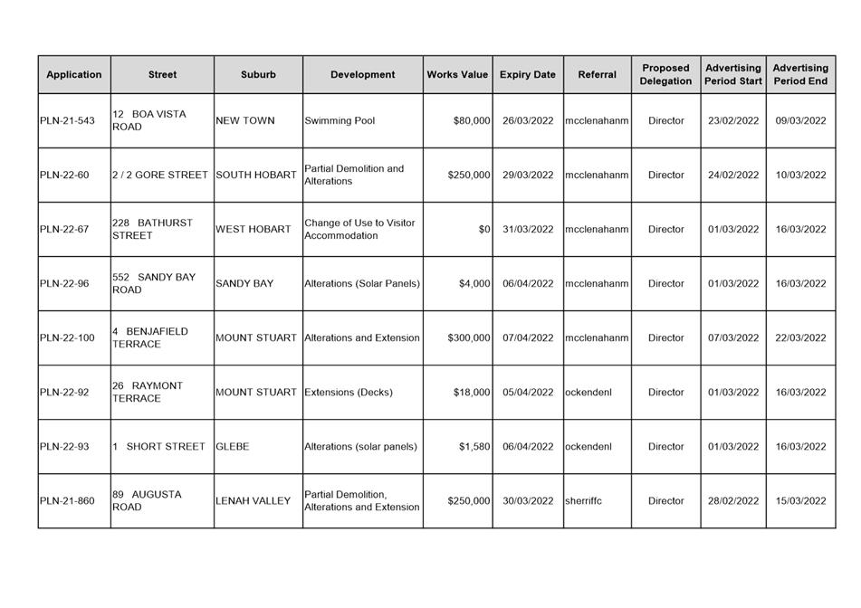
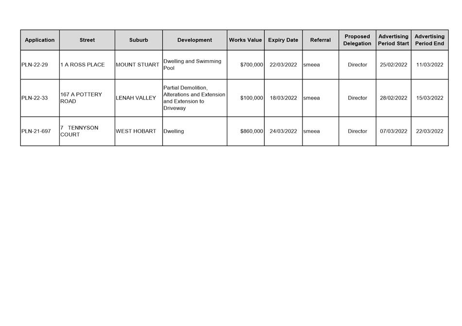
|
Agenda (Open Portion) City Planning Committee Meeting |
Page 267 |
|
|
|
21/3/2022 |
|
8.4 Delegated Decision Report (Planning)
Memorandum of the Acting Director City Life of 15 March 2022 and attachments.
Delegation: Committee
|
Item No. 8.4 |
Agenda (Open Portion) City Planning Committee Meeting |
Page 268 |
|
|
21/3/2022 |
|

Memorandum: City Planning Committee
Delegated Decision Report (Planning)
Attached is the delegated planning decisions report for the period 28 February 2022 to 11 March 2022.
|
That: 1. That the information be received and noted.
|
As signatory to this report, I certify that, pursuant to Section 55(1) of the Local Government Act 1993, I hold no interest, as referred to in Section 49 of the Local Government Act 1993, in matters contained in this report.
|
Karen Abey Acting Director City Life |
|
Date: 15 March 2022
File Reference: F22/23519
Attachment a: Delegated
Decision Report (Planning) ⇩ ![]()
|
Item No. 8.4 |
Agenda (Open Portion) City Planning Committee Meeting - 21/3/2022 |
Page 269 ATTACHMENT a |
|
Agenda (Open Portion) City Planning Committee Meeting |
Page 270 |
|
|
|
21/3/2022 |
|
9. Committee Action Status Report
A report indicating the status of current decisions is attached for the information of Elected Members.
REcommendation
That the information be received and noted.
Delegation: Committee
|
Item No. 9.1 |
Agenda (Open Portion) City Planning Committee Meeting - 21/3/2022 |
Page 275 ATTACHMENT a |
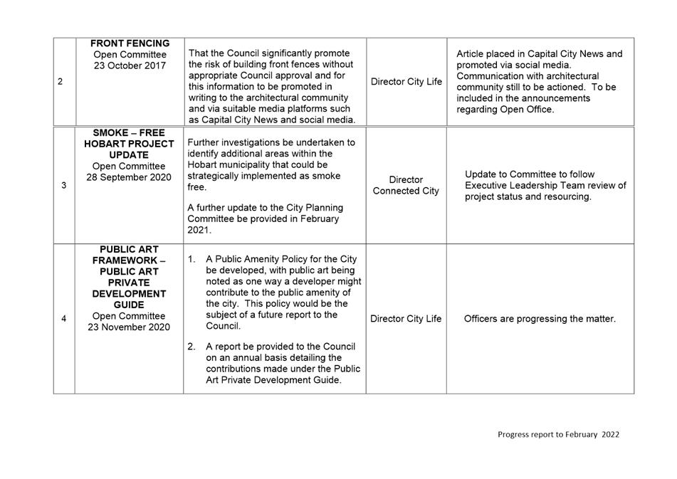
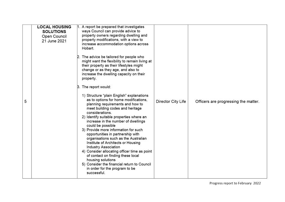
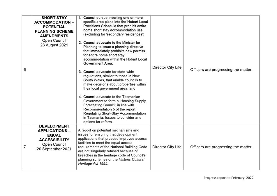
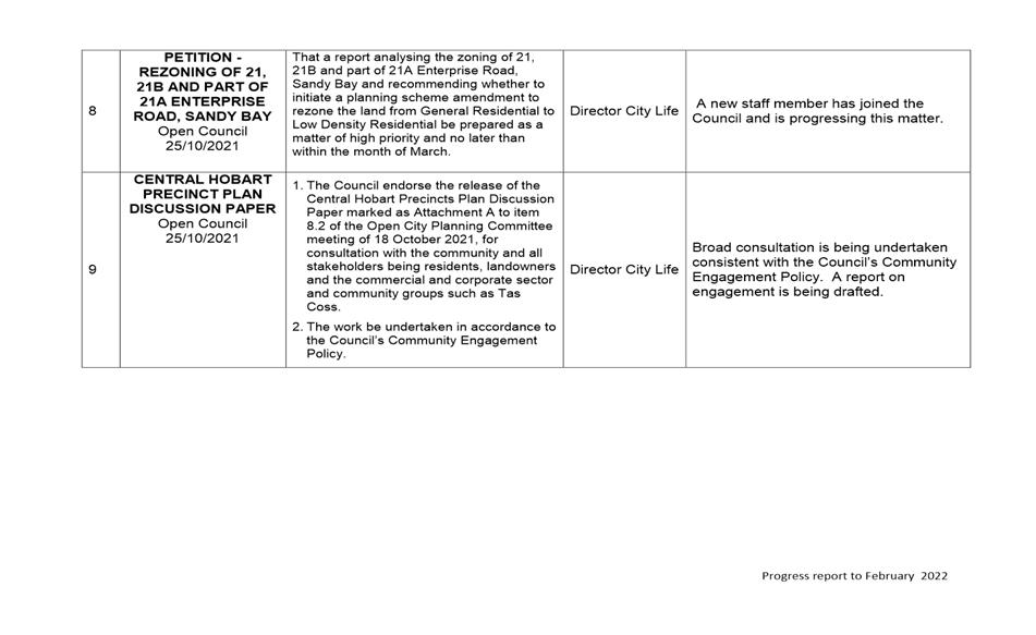
|
|
Agenda (Open Portion) City Planning Committee Meeting |
Page 276 |
|
|
21/3/2022 |
|
Section 29 of the Local Government (Meeting Procedures) Regulations 2015.
File Ref: 13-1-10
An Elected Member may ask a question without notice of the Chairman, another Elected Member, the Chief Executive Officer or the Chief Executive Officer’s representative, in line with the following procedures:
1. The Chairman will refuse to accept a question without notice if it does not relate to the Terms of Reference of the Council committee at which it is asked.
2. In putting a question without notice, an Elected Member must not:
(i) offer an argument or opinion; or
(ii) draw any inferences or make any imputations – except so far as may be necessary to explain the question.
3. The Chairman must not permit any debate of a question without notice or its answer.
4. The Chairman, Elected Members, Chief Executive Officer or Chief Executive Officer’s representative who is asked a question may decline to answer the question, if in the opinion of the respondent it is considered inappropriate due to its being unclear, insulting or improper.
5. The Chairman may require a question to be put in writing.
6. Where a question without notice is asked and answered at a meeting, both the question and the response will be recorded in the minutes of that meeting.
7. Where a response is not able to be provided at the meeting, the question will be taken on notice and
(i) the minutes of the meeting at which the question is asked will record the question and the fact that it has been taken on notice.
(ii) a written response will be provided to all Elected Members, at the appropriate time.
(iii) upon the answer to the question being circulated to Elected Members, both the question and the answer will be listed on the agenda for the next available ordinary meeting of the committee at which it was asked, where it will be listed for noting purposes only.
|
|
Agenda (Open Portion) City Planning Committee Meeting |
Page 277 |
|
|
21/3/2022 |
|