City
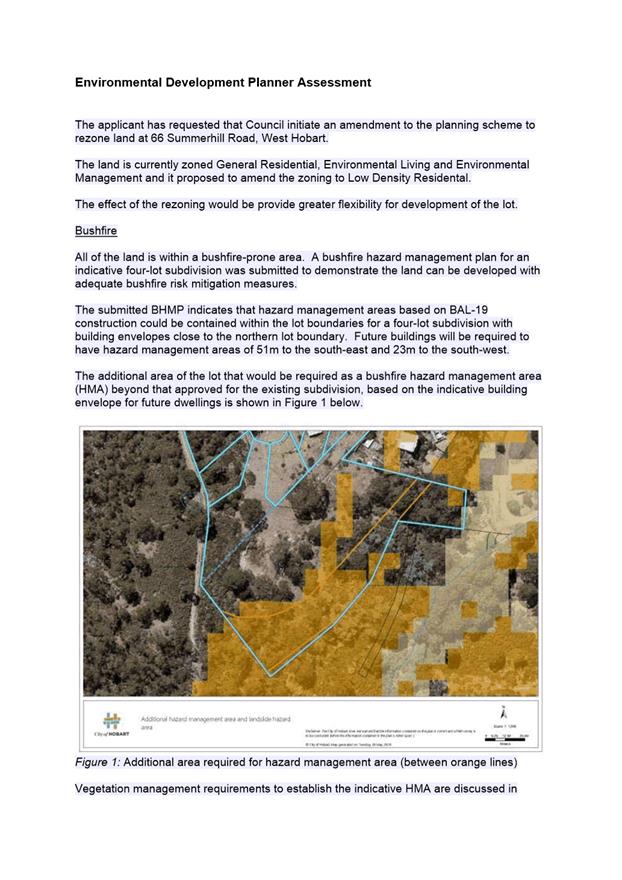
of hobart
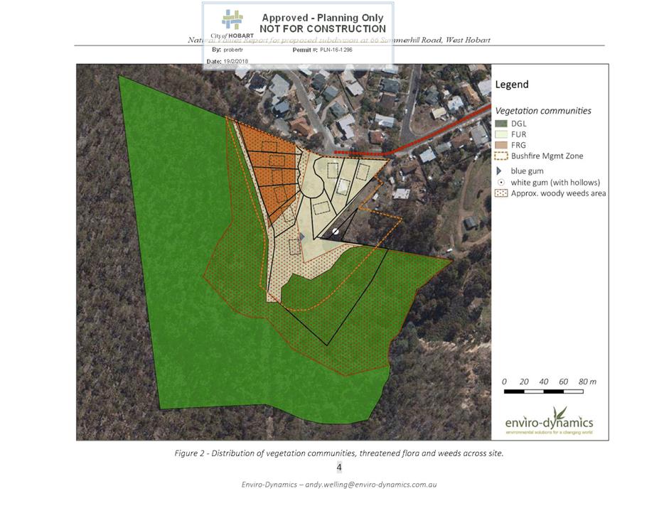
AGENDA
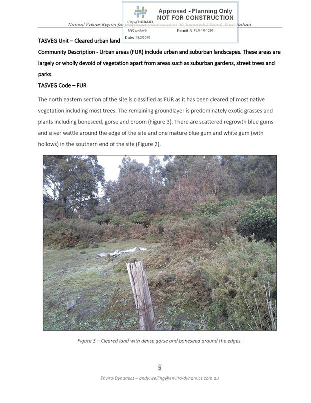
City Planning Committee Meeting
Open Portion
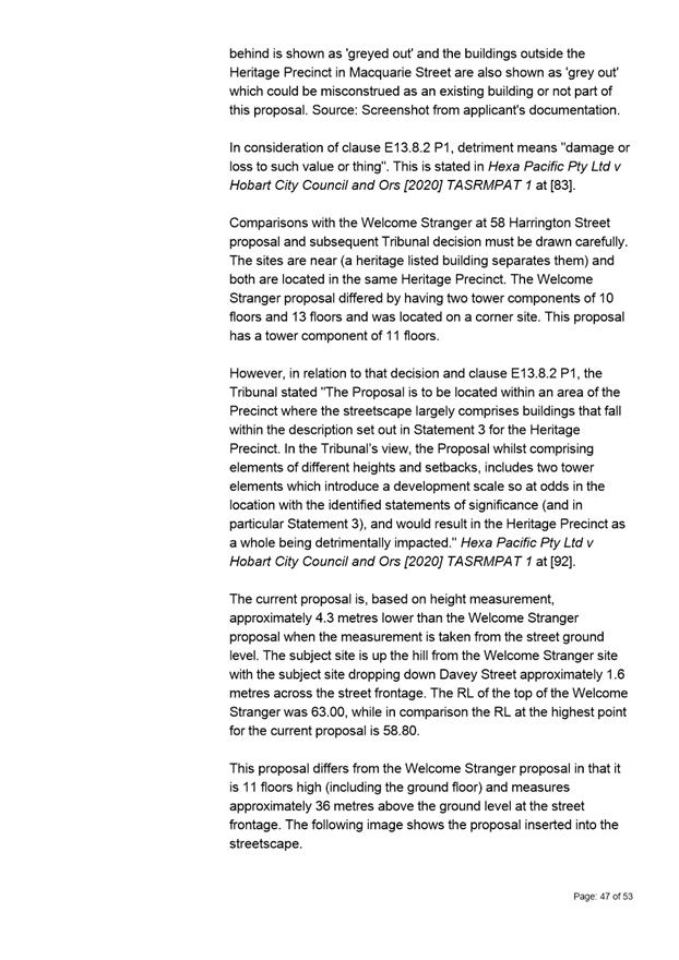
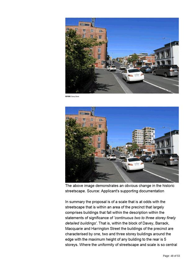
Monday, 19 October 2020
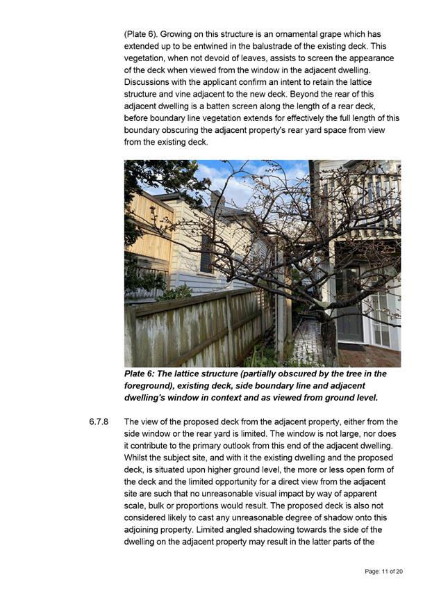
at 5:00 pm
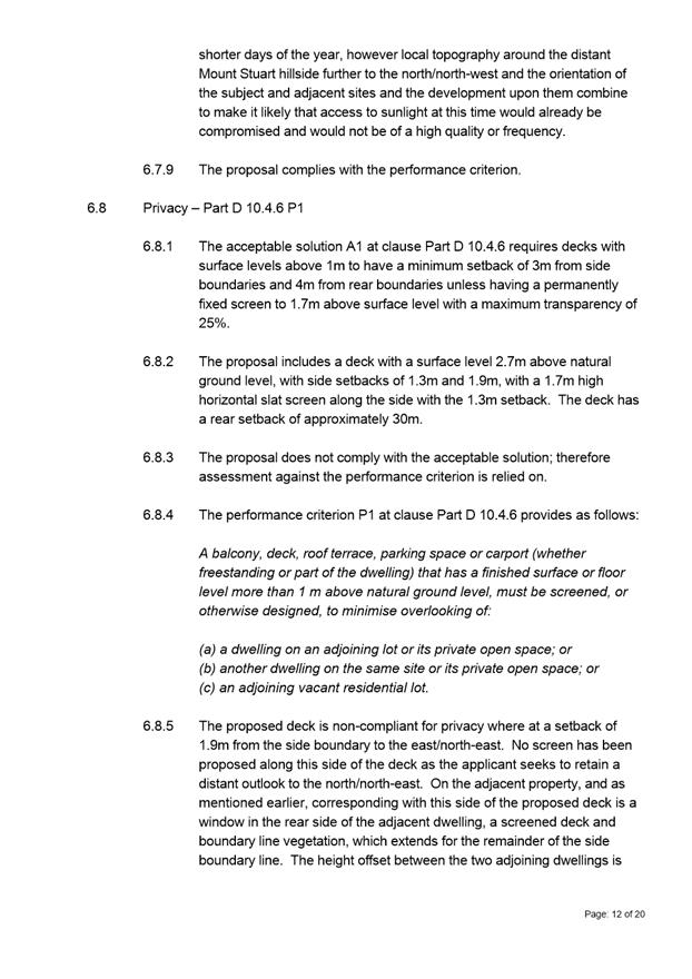
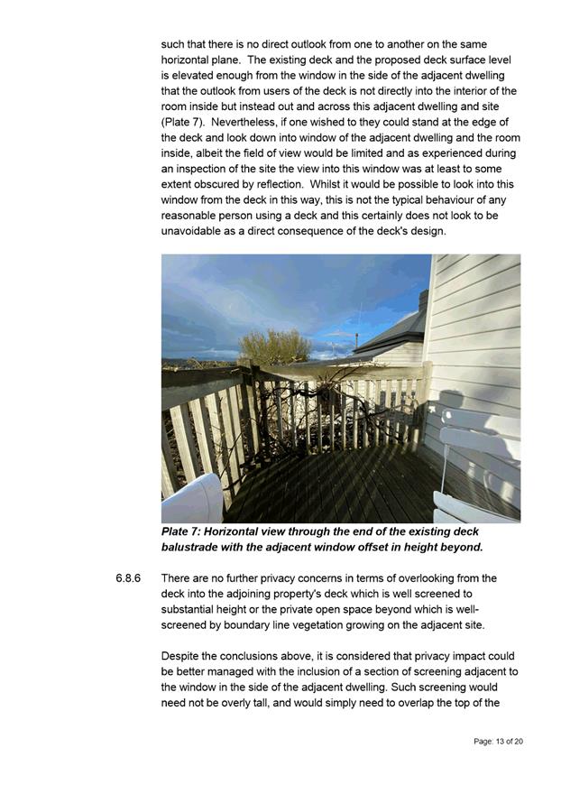
City
of hobart
AGENDA
City Planning Committee Meeting
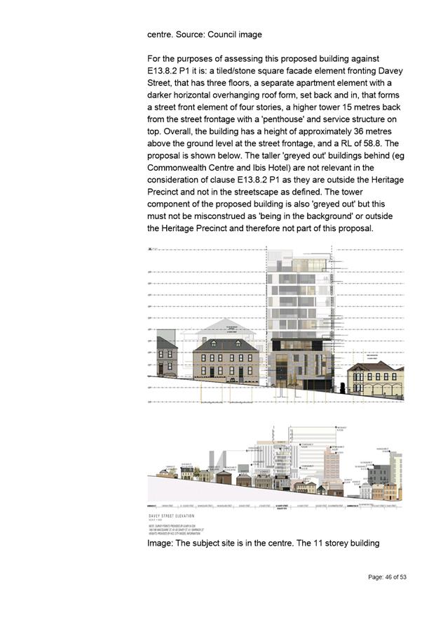
Open Portion
Monday, 19 October 2020
at 5:00 pm
Working together to make Hobart a better place for the community.
THE VALUES
The Council is:
|
People |
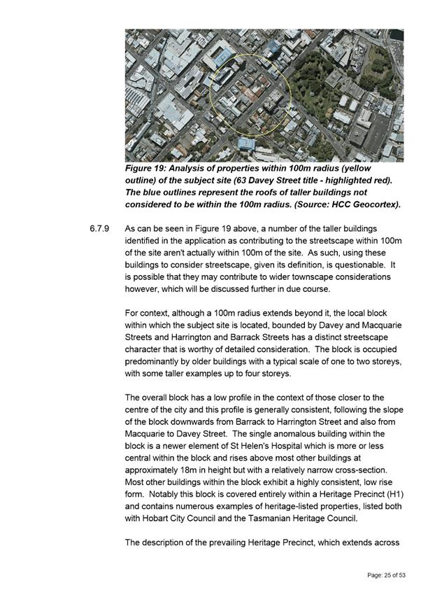
We care about people – our community, our customers and colleagues. |
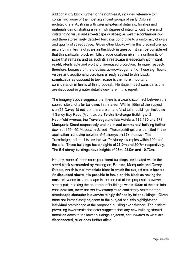
|
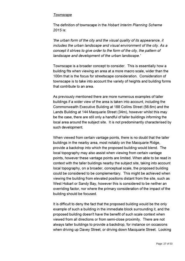
Teamwork |
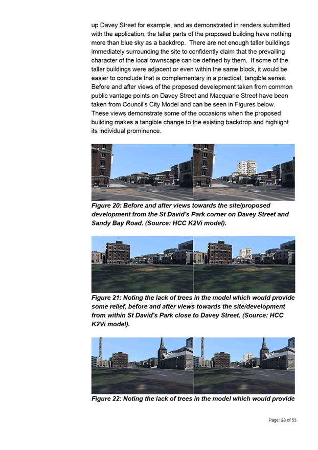
We collaborate both within the organisation and with external stakeholders drawing on skills and expertise for the benefit of our community. |
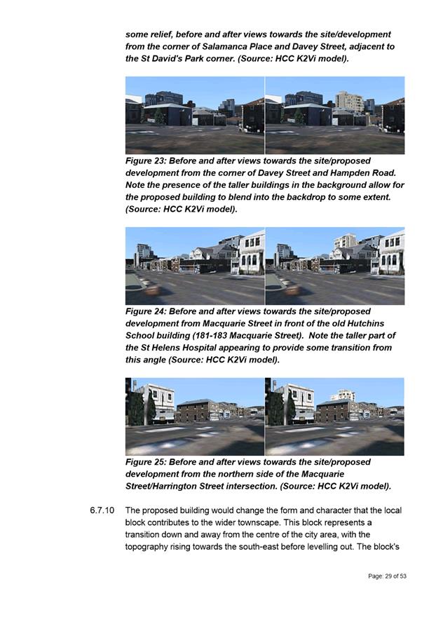
|
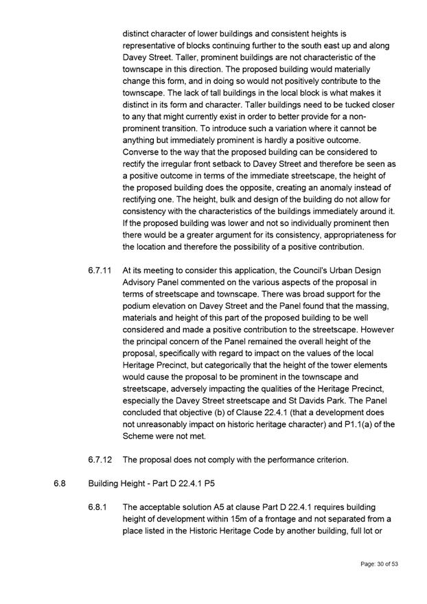
Focus and Direction |
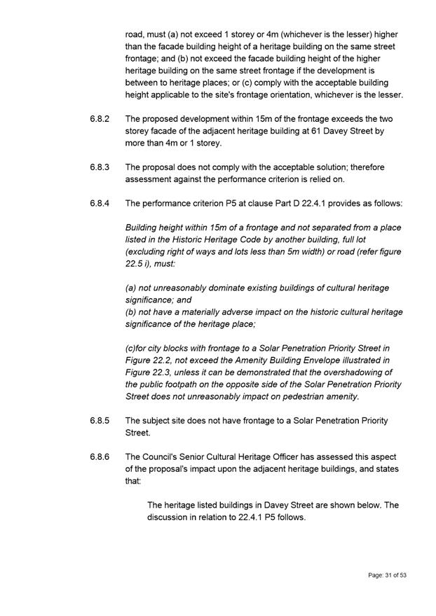
We have clear goals and plans to achieve sustainable social, environmental and economic outcomes for the Hobart community. |
|
Creativity and Innovation |
We embrace new approaches and continuously improve to achieve better outcomes for our community. |
|
Accountability |
We are transparent, work to high ethical and professional standards and are accountable for delivering outcomes for our community. |
|
|
Agenda (Open Portion) City Planning Committee Meeting |
Page 4 |
|
|
19/10/2020 |
|
Business listed on the agenda is to be conducted in the order in which it is set out, unless the committee by simple majority determines otherwise.
APOLOGIES AND LEAVE OF ABSENCE
1. Co-Option of a Committee Member in the event of a vacancy
3. Consideration of Supplementary Items
4. Indications of Pecuniary and Conflicts of Interest
6. Planning Authority Items - Consideration of Items With Deputations
7. Committee Acting as Planning Authority
7.1 Applications under the Hobart Interim Planning Scheme 2015
7.1.2 518 Huon Road, South Hobart - Security Fence and Gates
7.1.3 354 Macquarie Street, South Hobart - Partial Demolition and Extension
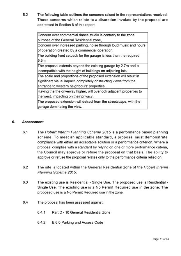
7.1.4 39 Nicholas Drive, Sandy Bay - Partial Demolition, Alterations and Extension
7.1.7 19 Allison Street, West Hobart - Partial Demolition and Alterations
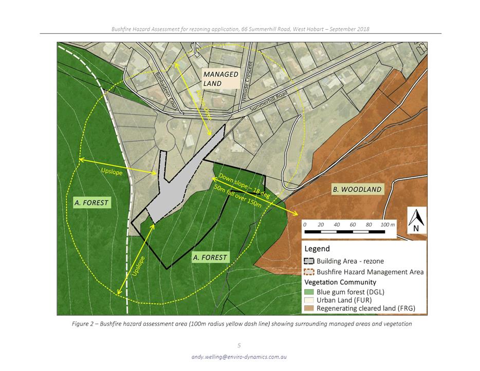
8.1 Amendment PSA-18-2 - Hobart Interim Planning Scheme 2015 - 66 Summerhill Road Rezoning
8.2 Delegated Decisions Report (Planning)
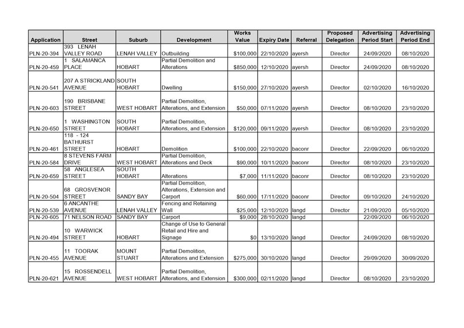
8.3 City Planning - Advertising Report
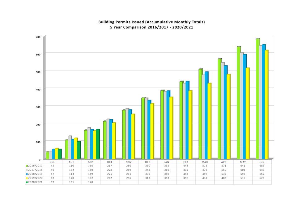
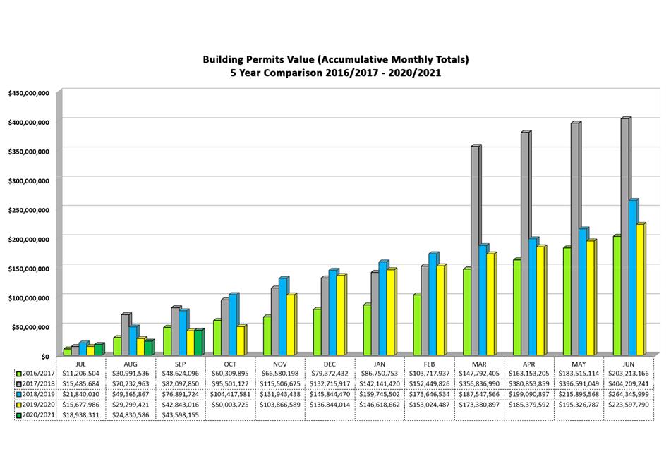
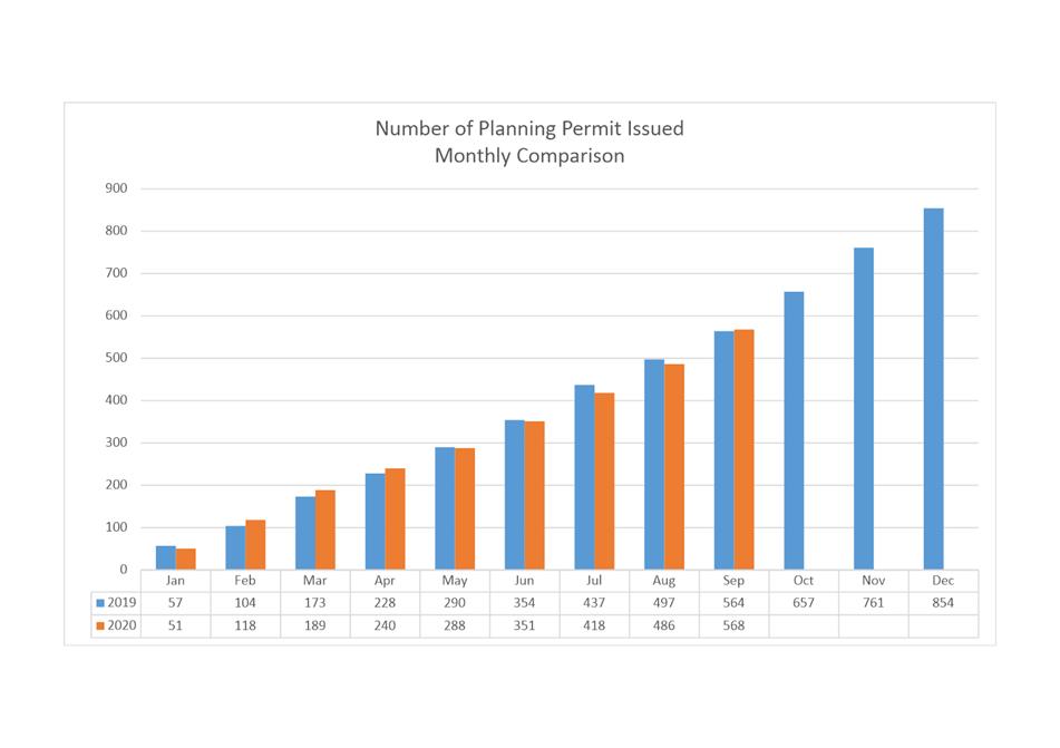
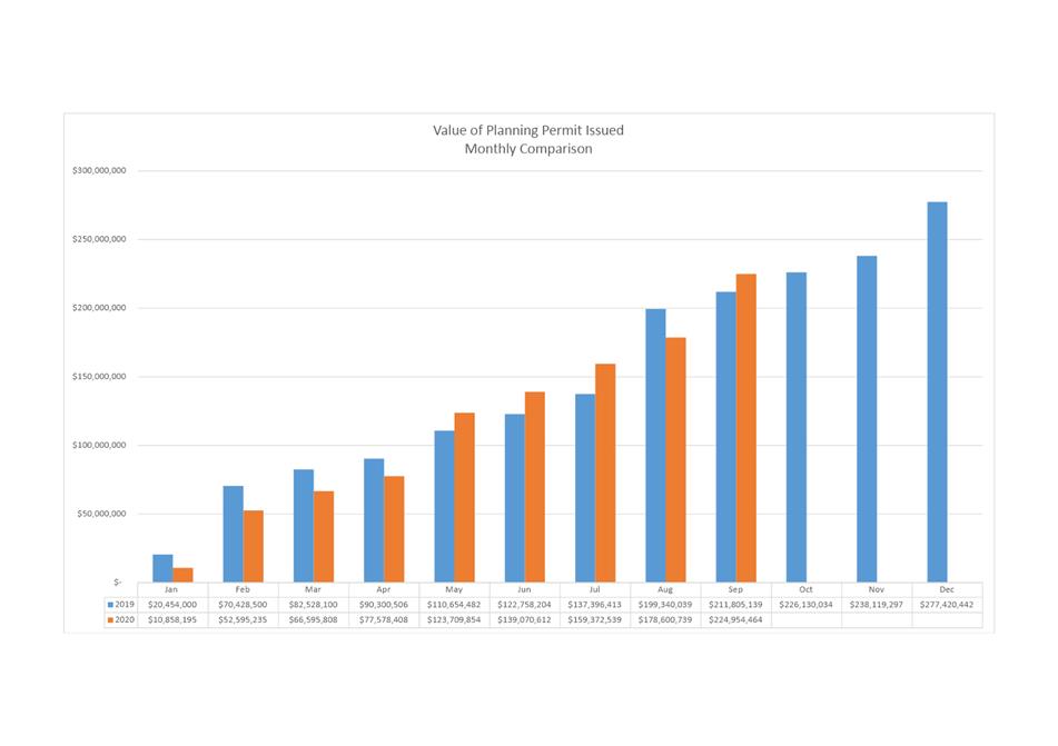
8.4 Monthly Building and Planning Statistics - 1 September - 30 September 2020
9. Responses To Questions Without Notice
9.1 Planning Decisions - Residential Dwellings
9.2 Section 56 Land Use Planning Approvals Act 1993 - Minor Amendments
9.3 Building Heights - Planning Recommendations
11. Closed Portion Of The Meeting
|
|
Agenda (Open Portion) City Planning Committee Meeting |
Page 6 |
|
|
19/10/2020 |
|
City Planning Committee Meeting (Open Portion) held Monday, 19 October 2020 at 5:00 pm.
This meeting of the City Planning Committee is held in accordance with a Notice issued by the Premier on 3 April 2020 under section 18 of the COVID-19 Disease Emergency (Miscellaneous Provisions) Act 2020.
|
COMMITTEE MEMBERS Deputy Lord Mayor Burnet (Chairman) Briscoe Harvey Behrakis Dutta Coats
NON-MEMBERS Lord Mayor Reynolds Zucco Sexton Thomas Ewin Sherlock |
Apologies:
Leave of Absence: Nil.
|
|
The minutes of the Open Portion of the City Planning Committee meeting held on Monday, 28 September 2020 and the Special City Planning Committee meeting held on Monday, 12 October 2020, are submitted for confirming as an accurate record.
|
Ref: Part 2, Regulation 8(6) of the Local Government (Meeting Procedures) Regulations 2015.
|
That the Committee resolve to deal with any supplementary items not appearing on the agenda, as reported by the General Manager.
|
Ref: Part 2, Regulation 8(7) of the Local Government (Meeting Procedures) Regulations 2015.
Members of the committee are requested to indicate where they may have any pecuniary or conflict of interest in respect to any matter appearing on the agenda, or any supplementary item to the agenda, which the committee has resolved to deal with.
Regulation 15 of the Local Government (Meeting Procedures) Regulations 2015.
A committee may close a part of a meeting to the public where a matter to be discussed falls within 15(2) of the above regulations.
In the event that the committee transfer an item to the closed portion, the reasons for doing so should be stated.
Are there any items which should be transferred from this agenda to the closed portion of the agenda, or from the closed to the open portion of the agenda?
In accordance with the requirements of Part 2 Regulation 8(3) of the Local Government (Meeting Procedures) Regulations 2015, the General Manager is to arrange the agenda so that the planning authority items are sequential.
In accordance with Part 2 Regulation 8(4) of the Local Government (Meeting Procedures) Regulations 2015, the Committee by simple majority may change the order of any of the items listed on the agenda, but in the case of planning items they must still be considered sequentially – in other words they still have to be dealt with as a single group on the agenda.
Where deputations are to be received in respect to planning items, past practice has been to move consideration of these items to the beginning of the meeting.
RECOMMENDATION
That in accordance with Regulation 8(4) of the Local Government (Meeting Procedures) Regulations 2015, the Committee resolve to deal with any items which have deputations by members of the public regarding any planning matter listed on the agenda, to be taken out of sequence in order to deal with deputations at the beginning of the meeting.
|
|
Agenda (Open Portion) City Planning Committee Meeting |
Page 7 |
|
|
19/10/2020 |
|
In accordance with the provisions of Part 2 Regulation 25 of the Local Government (Meeting Procedures) Regulations 2015, the intention of the Committee to act as a planning authority pursuant to the Land Use Planning and Approvals Act 1993 is to be noted.
In accordance with Regulation 25, the Committee will act as a planning authority in respect to those matters appearing under this heading on the agenda, inclusive of any supplementary items.
The Committee is reminded that in order to comply with Regulation 25(2), the General Manager is to ensure that the reasons for a decision by a Council or Council Committee acting as a planning authority are recorded in the minutes.
|
Agenda (Open Portion) City Planning Committee Meeting |
Page 9 |
|
|
|
19/10/2020 |
|
7.1 Applications under the Hobart Interim Planning Scheme 2015
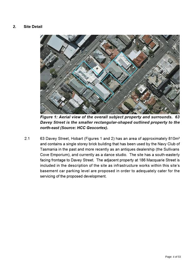
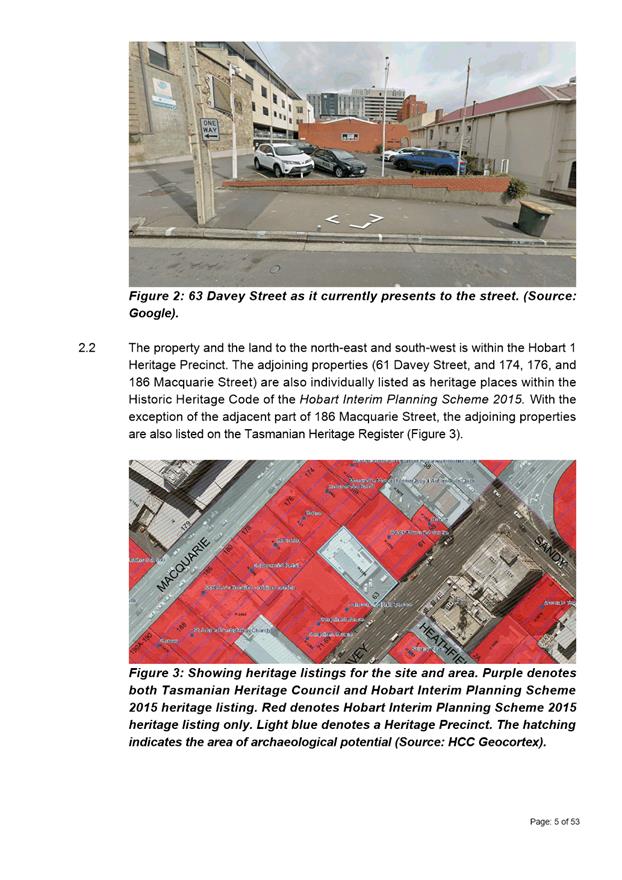
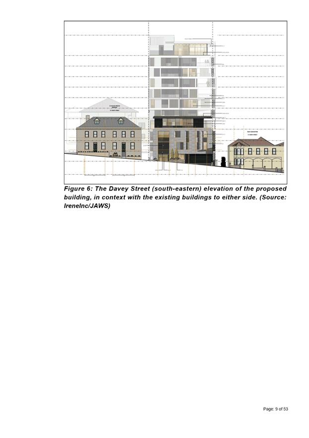
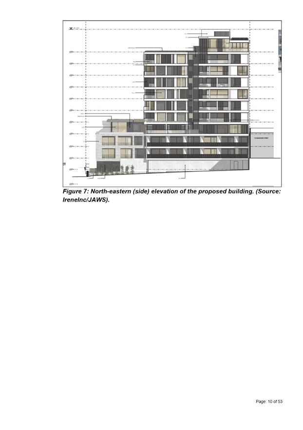
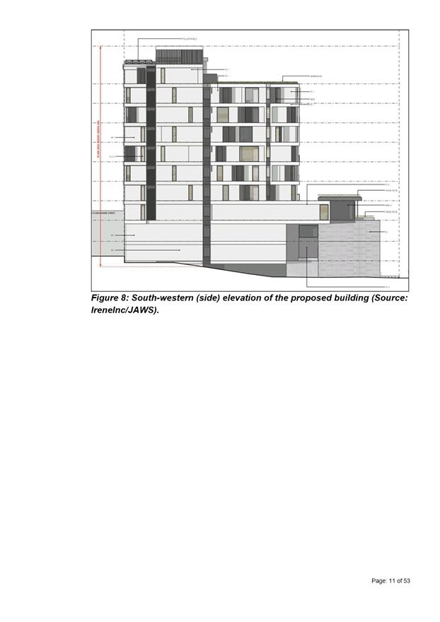
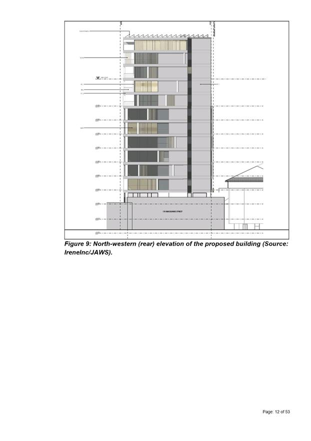
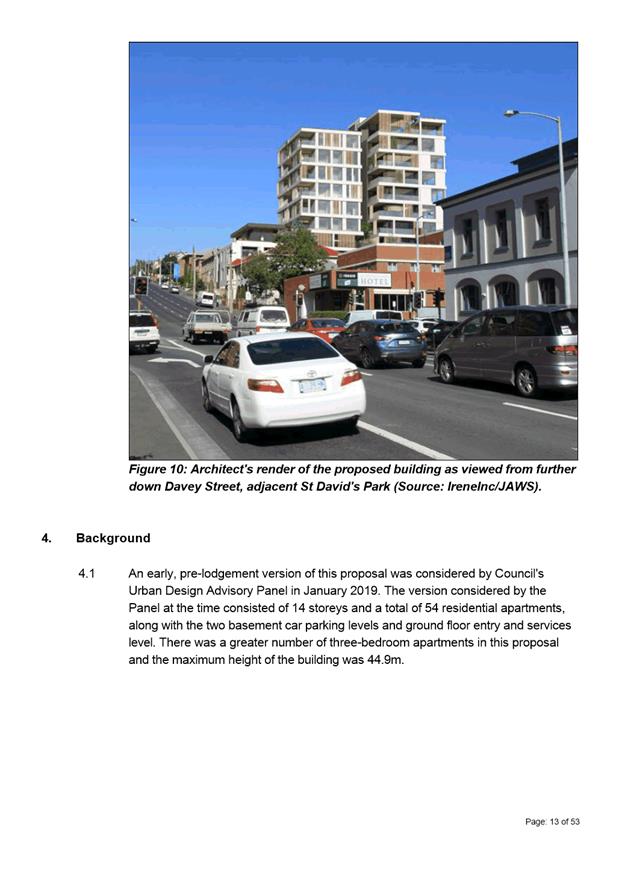
7.1.1 63 Davey Street, Hobart and 186 Macquarie Street, Hobart, Adjacent Road Reserve - Demolition, New Building for 30 Multiple Dwellings and 21 Student Accommodation Units including Carparking, and Associated Infrastructure and Access Works
Address: 63 Davey Street and 186 Macquarie Street, Hobart and Adjacent Road Reserve
Proposal: Demolition, New Building for 30 Multiple Dwellings and 21 Student Accommodation Units including Carparking, and Associated Infrastructure and Access Works
Expiry Date: 27 October 2020
Extension of Time: Not applicable
Author: Cameron Sherriff
|
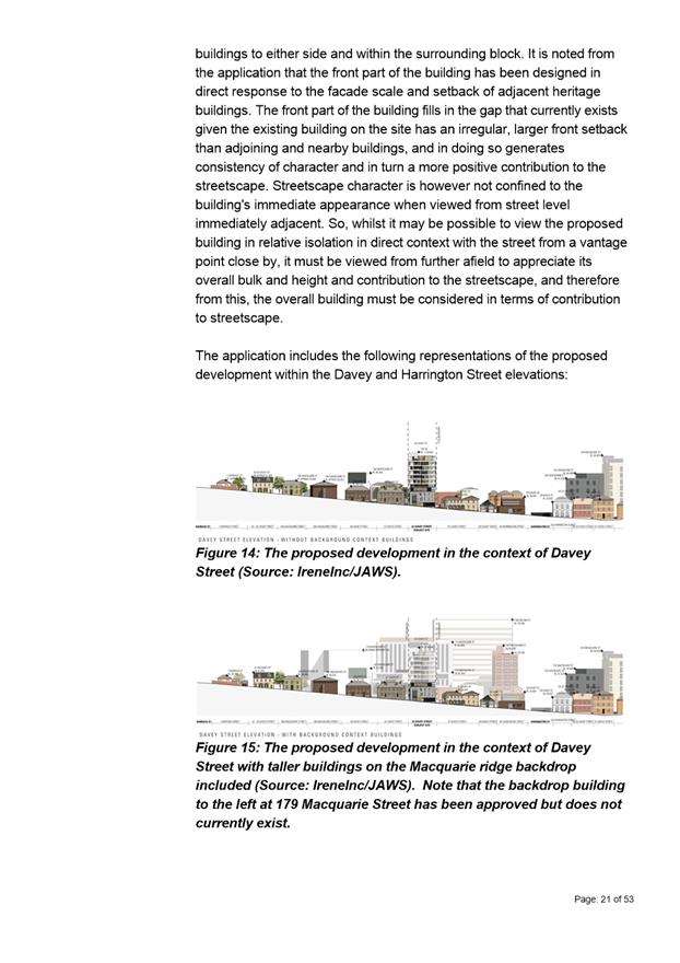
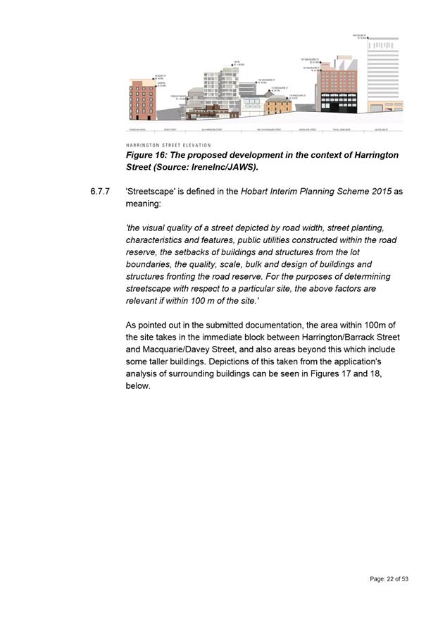
REcommendation That pursuant to the Hobart Interim Planning Scheme 2015, the Council refuse the application for demolition, new building for 30 multiple dwellings and 21 student accommodation units including carparking, and associated infrastructure and access works at 63 Davey Street and 186 Macquarie Street, HOBART and adjacent road reserve, for the following reasons:
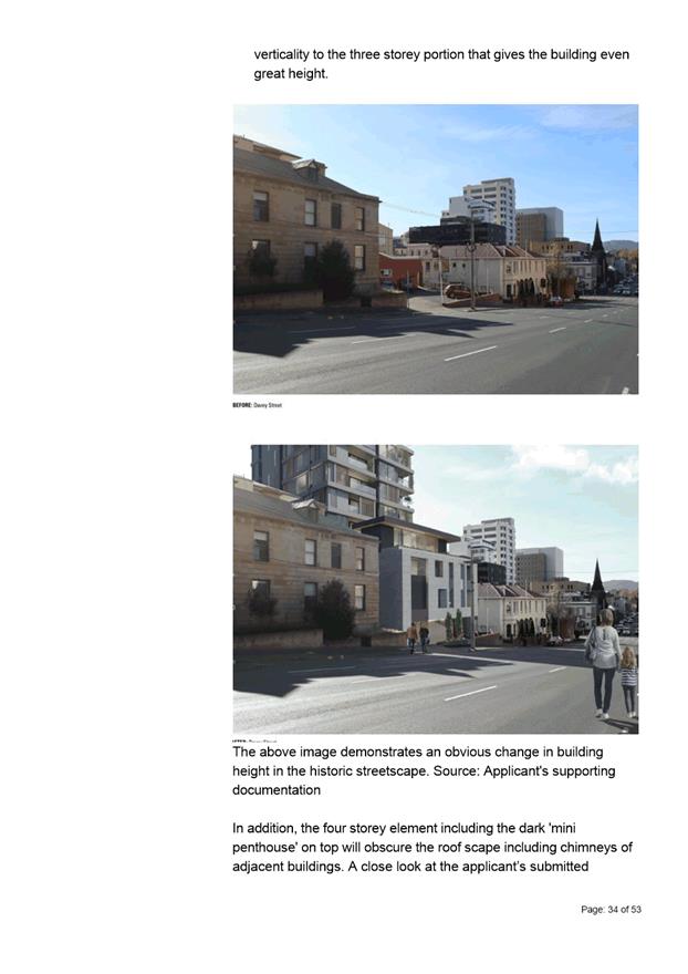
1. The proposal does not meet the acceptable solution or the performance criterion with respect to clause Part D 22.4.1 A1 and P1.1(a) of the Hobart Interim Planning Scheme 2015 because the development does not make a positive contribution to the streetscape and townscape, having regard to the height, bulk and design of existing and proposed buildings.
2. The proposal does not meet the acceptable solution or the performance criterion with respect to clause E13.8.2 P1 of the Historic Heritage Code of the Hobart Interim Planning Scheme 2015 because the proposal results in detriment to the historic cultural heritage significance of the precinct through its design and siting.
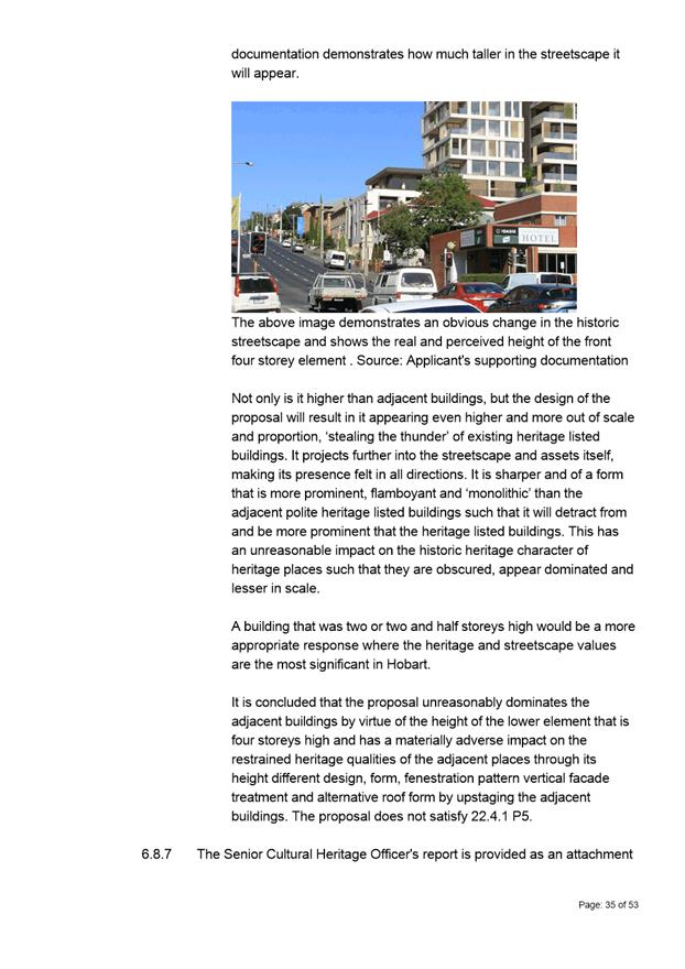
3. The proposal does not meet the acceptable solution or the performance criterion with respect to clause 22.4.1 P5 of the Historic Heritage Code of the Hobart Interim Planning Scheme 2015 because the proposed building unreasonably dominates and has a materially adverse impact on adjacent existing buildings of cultural heritage significance through its height.
|
Attachment a: PLN-19-319
- 63 DAVEY STREET HOBART TAS 7000 - Planning Committee or Delegated Report ⇩ ![]()
Attachment
b: PLN-19-319
- 63 Davey Street Hobart TAS 7000 - CPC Agenda Documents (Supporting
information) ![]()
Attachment
c: PLN-19-319
- 63 DAVEY STREET HOBART TAS 7000 - Planning Referral Officer Cultural Heritage
Report (Supporting information) ![]()
Attachment
d: PLN-19-319
- 63 DAVEY STREET HOBART TAS 7000 - Planning Referral Officer Development
Engineering Report (Supporting information) ![]()
Attachment
e: PLN-19-319
- 63 DAVEY STREET HOBART TAS 7000 - UDAP Minutes (Supporting information) ![]()
|
Item No. 7.1.1 |
Agenda (Open Portion) City Planning Committee Meeting - 19/10/2020 |
Page 21 ATTACHMENT a |
|
Agenda (Open Portion) City Planning Committee Meeting |
Page 64 |
|
|
|
19/10/2020 |
|
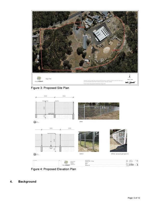
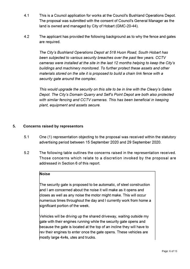
7.1.2 518 Huon Road, South Hobart - Security Fence and Gates
Address: 518 Huon Road, South Hobart
Proposal: Security Fence and Gates
Expiry Date: 19 November 2020
Extension of Time: Not applicable
Author: Mark O’Brien
|
REcommendation That pursuant to the Hobart Interim Planning Scheme 2015, the Council approve the application for security fence and gates at 518 Huon Road, South Hobart for the reasons outlined in the officer’s report and a permit containing the following conditions be issued:
GEN
The use and/or development must be substantially in accordance with the documents and drawings that comprise PLN20438 518 HUON ROAD SOUTH HOBART TAS 7004 Final Planning Documents, except where modified below.
Reason for condition
To clarify the scope of the permit.
ENV 1
Sediment and erosion control measures sufficient to prevent sediment from leaving the site must be installed prior to any disturbance of the site, and maintained until all areas of disturbance have been stabilized or revegetated.
Advice:
For further guidance in preparing a Soil and Water Management Plan – in accordance with Fact sheet 3 Derwent Estuary Program click here.
Reason for condition
To avoid the sedimentation of roads, drains, natural watercourses, Council land that could be caused by erosion and runoff from the development, and to comply with relevant State legislation.
ADVICE
The following advice is provided to you to assist in the implementation of the planning permit that has been issued subject to the conditions above. The advice is not exhaustive and you must inform yourself of any other legislation, bylaws, regulations, codes or standards that will apply to your development under which you may need to obtain an approval. Visit the Council's website for further information.
Prior to any commencement of work on the site or commencement of use the following additional permits/approval may be required from the Hobart City Council.
BUILDING PERMIT
You may need building approval in accordance with the Building Act 2016. Click here for more information.
WEED CONTROL
Effective measures are detailed in the Tasmanian Washdown Guidelines for Weed and Disease Control: Machinery, Vehicles and Equipment (Edition 1, 2004). The guidelines can be obtained from the Department of Primary Industries, Parks, Water and Environment website.
|
Attachment a: PLN-20-438
- 518 HUON ROAD SOUTH HOBART TAS 7004 - Planning Committee or Delegated Report ⇩ ![]()
Attachment
b: PLN
-20-438 - 518 HUON ROAD SOUTH HOBART TAS 7004 - CPC Agenda Documents
(Supporting information) ![]()
|
Item No. 7.1.2 |
Agenda (Open Portion) City Planning Committee Meeting - 19/10/2020 |
Page 77 ATTACHMENT a |
|
Agenda (Open Portion) City Planning Committee Meeting |
Page 80 |
|
|
|
19/10/2020 |
|
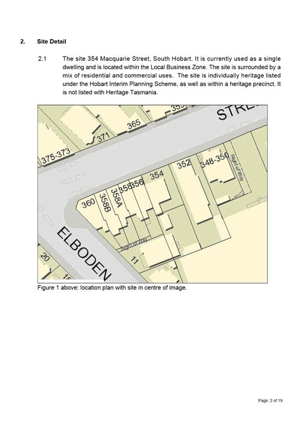
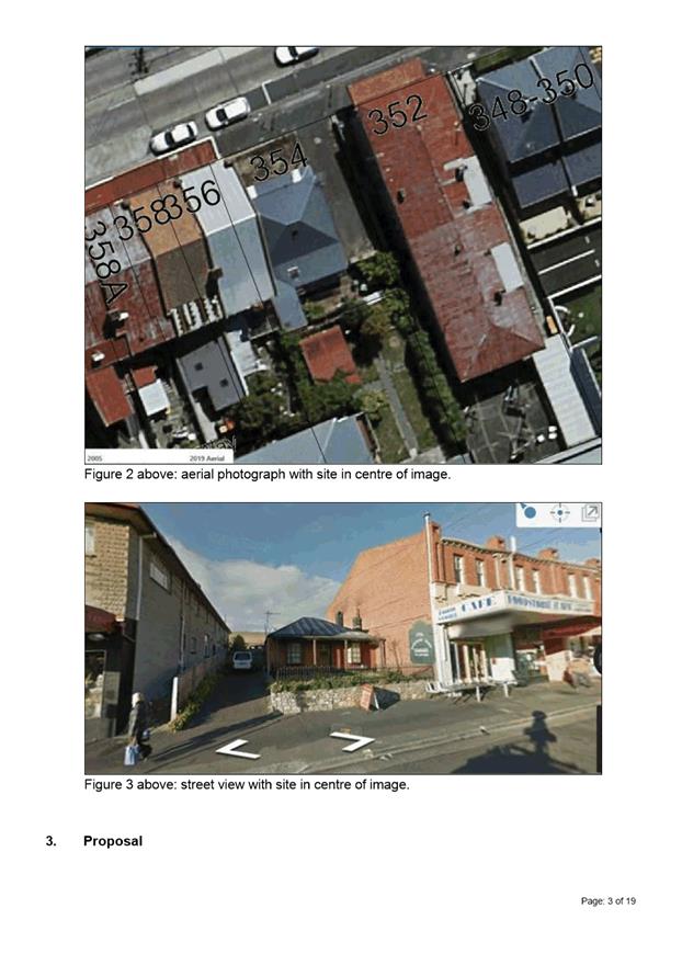
7.1.3 354 Macquarie Street, South Hobart - Partial Demolition and Extension
Address: 354 Macquarie Street, South Hobart
Proposal: Partial Demolition and Extension
Expiry Date: 14 November 2020
Extension of Time: Not applicable
Author: Richard Bacon
|
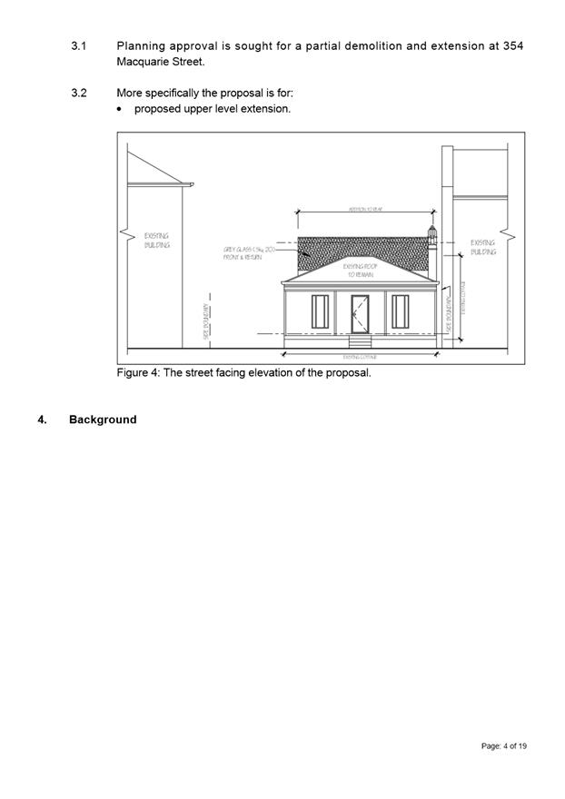
REcommendation That pursuant to the Hobart Interim Planning Scheme 2015, the Council refuse the application for a partial demolition and extension at 354 Macquarie Street, South Hobart TAS 7004 for the following reasons:
1 The proposal does not meet the acceptable solution or the performance criterion with respect to clause E13.7.2 A1 and P1 of the Hobart Interim Planning Scheme 2015 because the proposed extension, by reason of its height, size, bulk, use of fully glazed elevations, additional fenestration and architectural form would represent an incompatible design that would fail to be sympathetic, subservient or complementary to the dominant characteristics of the Cottage, to the detriment to its recognised historic cultural heritage significance.
2 The proposal does not meet the acceptable solution or the performance criterion with respect to clause E13.7.2 A2 and P2 of the Hobart Interim Planning Scheme 2015 because the proposed extension, by reason of its height, size, bulk, use of fully glazed elevations, additional fenestration and architectural form would represent an incompatible design that would fail to be sympathetic, subservient or complementary to the dominant characteristics of the Cottage, to the detriment to its recognised historic cultural heritage significance.
3 The proposal does not meet the acceptable solution or the performance criterion with respect to clause E13.7.2 A3 and P3 of the Hobart Interim Planning Scheme 2015 because the proposed extension, by reason of its height, size, bulk, use of fully glazed elevations, additional fenestration and architectural form would represent an incompatible design that would fail to be sympathetic, subservient or complementary to the dominant characteristics of the Cottage, to the detriment to its recognised historic cultural heritage significance.
4 The proposal does not meet the acceptable solution or the performance criterion with respect to clause E13.7.2 A4 and P4 of the Hobart Interim Planning Scheme 2015 because the proposed extension, by reason of its height, size, bulk, use of fully glazed elevations, additional fenestration and architectural form would represent an incompatible design that would fail to be sympathetic, subservient or complementary to the dominant characteristics of the Cottage, to the detriment to its recognised historic cultural heritage significance.
5 The proposal does not meet the acceptable solution or the performance criterion with respect to clause E13.8.2 A1 or P1 of the Hobart Interim Planning Scheme 2015 because the proposed extension, by reason of its design and fully glazed elevations would result in development unsympathetic to, and of detriment to the character and historic cultural heritage significance of the South Hobart/Macquarie Street/Cascade Road (SH2) Heritage Precinct.
6 The proposal does not meet the acceptable solution or the performance criterion with respect to clause E13.8.2 A3 or P3 of the Hobart Interim Planning Scheme 2015 because the proposed extension, by reason of its design and fully glazed elevations would result in development unsympathetic to, and of detriment to the character and historic cultural heritage significance of the South Hobart/Macquarie Street/Cascade Road (SH2) Heritage Precinct.
|
Attachment a: PLN-20-40
- 354 MACQUARIE STREET SOUTH HOBART TAS 7004 - Planning Committee or Delegated
Report ⇩ ![]()
Attachment
b: PLN-20-40
- 354 MACQUARIE STREET SOUTH HOBART TAS 7004 - CPC Agenda Documents (Supporting
information) ![]()
Attachment
c: PLN-20-40
- 354 MACQUARIE STREET SOUTH HOBART TAS 7004 - Planning Referral Officer
Cultural Heritage Report (Supporting information) ![]()
|
Item No. 7.1.3 |
Agenda (Open Portion) City Planning Committee Meeting - 19/10/2020 |
Page 99 ATTACHMENT a |
|
Agenda (Open Portion) City Planning Committee Meeting |
Page 108 |
|
|
|
19/10/2020 |
|
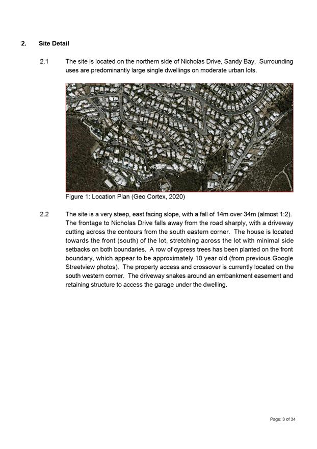
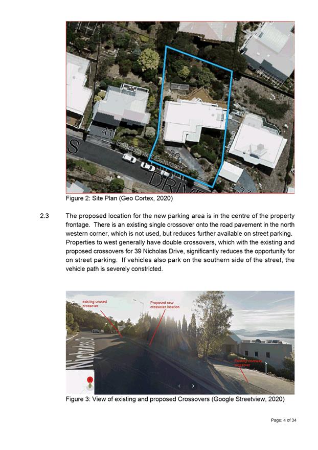
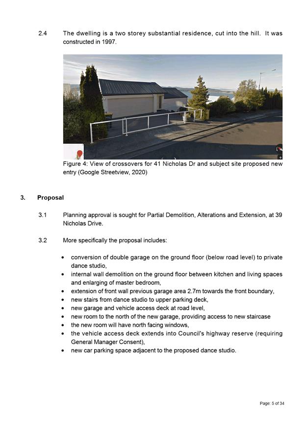
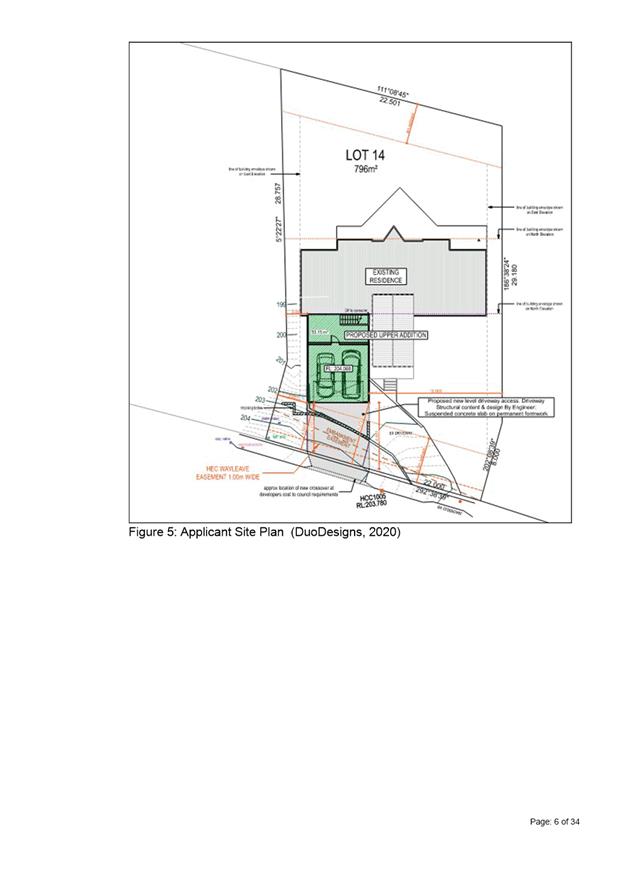
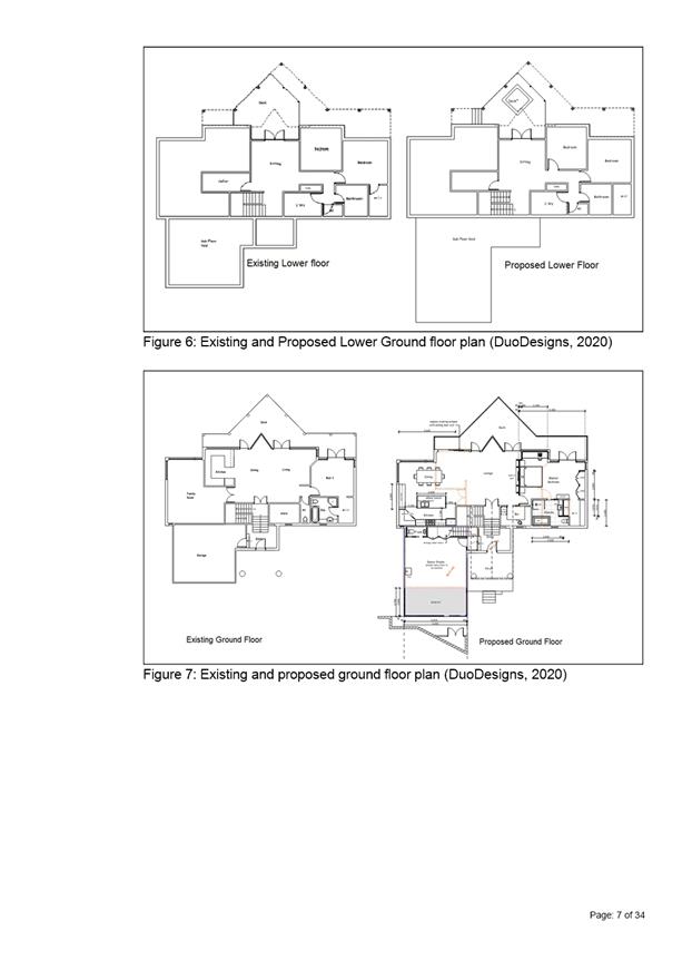
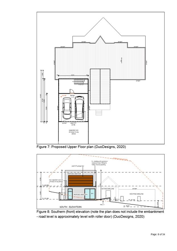
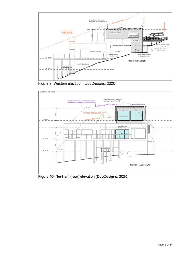
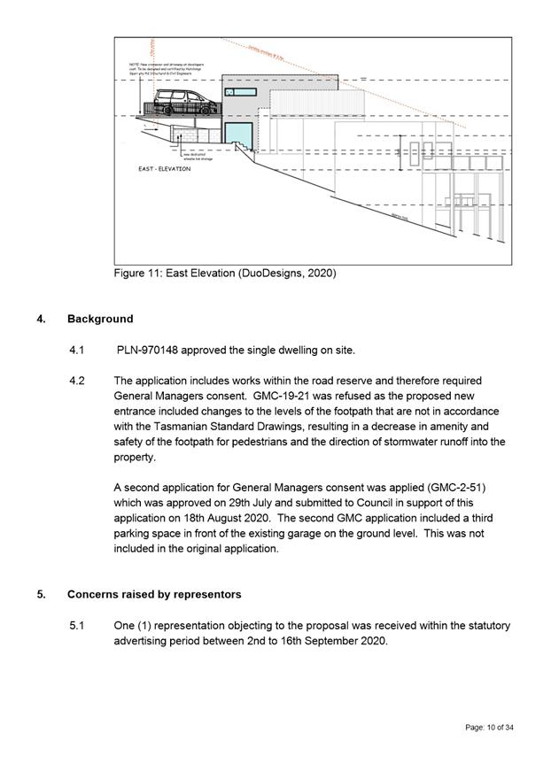
7.1.4 39 Nicholas Drive, Sandy Bay - Partial Demolition, Alterations and Extension
Address: 39 Nicholas Drive, Sandy Bay
Proposal: Partial Demolition, Alterations and Extension
Expiry Date: 19 October 2020
Extension of Time: Not applicable
Author: Victoria Maxwell
|
REcommendation That pursuant to the Hobart Interim Planning Scheme 2015, the City Planning Committee, in accordance with the delegations contained in its terms of reference, approve the application for partial demolition, alterations and extension at 39 NICHOLAS DRIVE SANDY BAY TAS 7005 for the reasons outlined in the officer’s report and a permit containing the following conditions be issued:
GEN
The use and/or development must be substantially in accordance with the documents and drawings that comprise PLN19468 39 NICHOLAS DRIVE SANDY BAY TAS 7005 Final Planning Documents except where modified below.
Reason for condition
To clarify the scope of the permit.
PLN s2
The dance studio is approved for the private use of the occupants of the dwelling at 39 Nicholas Drive only.
Reason for condition
To clarify the scope of this permit.
ENG 2a
Prior to first occupation or commencement of use (whichever occurs first), vehicular barriers compliant with the Australian Standard AS/NZS1170.1:2002 must be installed to prevent vehicles running off the edge of an access driveway or parking module (parking spaces, aisles and manoeuvring area) where the drop from the edge of the trafficable area to a lower level is 600mm or greater, and wheel stops (kerb) must be installed for drops between 150mm and 600mm. Barriers must not limit the width of the driveway access or parking and turning areas approved under the permit.
Advice:
The Council does not consider a slope greater than 1 in 4 to constitute a lower level as described in AS/NZS 2890.1:2004 Section 2.4.5.3. Slopes greater than 1 in 4 will require a vehicular barrier or wheel stop.
Designers are advised to consult the National Construction Code 2016 to determine if pedestrian handrails or safety barriers compliant with the NCC2016 are also required in the parking module this area may be considered as a path of access to a building.
Reason for condition
To ensure the safety of users of the access driveway and parking module and compliance with the standard.
ENG 2b
Prior to the issue of any approval under the Building Act 2016 or the commencement of works on site (whichever occurs first), a certified vehicle barrier design (including site plan with proposed location(s) of installation) prepared by a suitably qualified engineer, compliant with Australian Standard AS/NZS 1170.1:2002, must be submitted to the Council.
Advice:
If the development's building approval includes the need for a building permit from the Council, the applicant is advised to submit detailed design of vehicular barrier as part of the building application.
If the development's building approval is covered under Notifiable Work the applicant is advised to submit detailed design of vehicular barrier as a condition endorsement of the planning permit condition. Once the certification has been accepted, the Council will issue a condition endorsement (see general advice on how to obtain condition endorsement).
Reason for condition
To ensure the safety of users of the access driveway and parking module and compliance with the standard.
ENG 2c
Prior to the commencement of use, vehicular barriers must be inspected by a qualified engineer and certification submitted to the Council confirming that the installed vehicular barriers comply with the certified design and Australian Standard AS/NZS1170.1:2002.
Advice:
Certification may be submitted to the Council as part of the Building Act 2016 approval process or via condition endorsement (see general advice on how to obtain condition endorsement).
Reason for condition
To ensure the safety of users of the access driveway and parking module and compliance with the relevant standards.
ENG 3a
The access driveways and parking modules (parking spaces and manoeuvring areas) must be designed and constructed in accordance with Australian Standard AS/NZS2890.1:2004 (including the requirement for vehicle safety barriers where required), or a Council approved alternate design certified by a suitably qualified engineer to provide a safe and efficient access, and enable safe, easy and efficient use.
Advice:
It is advised that designers consider the detailed design of the access and parking module prior to finalising the Finished Floor Level (FFL) of the parking spaces (especially if located within a garage incorporated into the dwelling), as failure to do so may result in difficulty complying with this condition.
Reason for condition
To ensure the safety of users of the access and parking module, and compliance with the relevant Australian Standard.
ENG 3c
The access driveways and parking modules (parking spaces and manoeuvring areas) must be constructed in accordance with the Aldanmark Consulting Engineers documentation received by the Council on the 18th August 2020.
Prior to the commencement of use, documentation by a suitably qualified engineer certifying that the access driveways and parking modules have been constructed in accordance with the above drawings must be lodged with Council.
Advice:
Certification may be submitted to Council as part of the Building Act 2016 approval process or via condition endorsement (see general advice on how to obtain condition endorsement)
Reason for condition
To ensure the safety of users of the access and parking module, and compliance with the relevant Australian Standard.
ENG 4
The access driveways and parking modules (car parking spaces and manoeuvring areas) approved by this permit must be constructed to a sealed standard (spray seal, asphalt, concrete, pavers or equivalent Council approved) and surface drained to the Council's stormwater infrastructure prior to the commencement of use.
Reason for condition
To ensure the safety of users of the access driveway and parking module, and that it does not detract from the amenity of users, adjoining occupiers or the environment by preventing dust, mud and sediment transport.
ENG 5
The number of car parking spaces approved on the site is three (3).
Reason for condition
To ensure the provision of parking for the use is safe and efficient.
ENG 11
Prior to the first occupation, the proposed crossover to the Nicholas Drive highway reservation must be designed and constructed in general accordance with:
1. LGAT Standard Drawing Urban TSDR09v2 – Urban Roads Driveways and TSD R14v2 Type KC vehicular crossing 2. LGAT Standard Drawing Footpath Urban Roads Footpaths TSDR11 v2 3. Or a Council City Infrastructure Division approved alternate design.
Advice:
Local Government Association (LGAT) Tasmanian Standard Drawings (TSD) can be viewed electronically via the LGAT Website.
It is advised that designers consider the detailed design of the crossover, access and parking module prior to finalising the Finished Floor Level (FFL) of the parking spaces (especially if located within a garage incorporated into the dwelling), as failure to do so may result in difficulty complying with this condition.
Please note that your proposal does not include adjustment of footpath levels. Any adjustment to footpath levels necessary to suit the design of proposed floor, parking module or driveway levels will require separate agreement from Council's Road Services Engineer and may require further planning approvals. It is advised to place a note to this affect on construction drawings for the site and/or other relevant engineering drawings to ensure that contractors are made aware of this requirement.
Please contact the Council’s City Amenity Division to discuss approval of alternate designs. Based on a site specific assessment, the Council’s City Amenity Division’s Road Engineer may permit extending nonapproved concrete slab crossover, and where nonstandard kerb and channel exists a concrete plinth to Council standards may be permitted for construction at the gutter.
You are likely to require a Permit to Open Up and Temporarily Occupy a Highway (for work within the highway reservation). Click here for more information.
Reason for condition
In the interests of vehicle user safety and the amenity of the development.
ADVICE
The following advice is provided to you to assist in the implementation of the planning permit that has been issued subject to the conditions above. The advice is not exhaustive and you must inform yourself of any other legislation, bylaws, regulations, codes or standards that will apply to your development under which you may need to obtain an approval. Visit the Council's website for further information.
Prior to any commencement of work on the site or commencement of use the following additional permits/approval may be required from the Hobart City Council.
CONDITION ENDORSEMENT ENGINEERING
All engineering drawings required to be submitted and approved by this planning permit must be submitted to the City of Hobart as a CEP (Condition Endorsement) via the City’s Online Service Development Portal. When lodging a CEP, please reference the PLN number of the associated Planning Application. Each CEP must also include an estimation of the cost of works shown on the submitted engineering drawings. Once that estimation has been confirmed by the City’s Engineer, the following fees are payable for each CEP submitted and must be paid prior to the City of Hobart commencing assessment of the engineering drawings in each CEP:
Value of Building Works Approved by Planning Permit Fee: Up to $20,000: $150 per application. Over $20,000: 2% of the value of the works as assessed by the City's Engineer per assessment.
These fees are additional to building and plumbing fees charged under the Building and Plumbing Regulations.
Once the CEP is lodged via the Online Service Development Portal, if the value of building works approved by your planning permit is over $20,000, please contact the City’s Development Engineer on 6238 2715 to confirm the estimation of the cost of works shown on the submitted engineering drawings has been accepted.
Once confirmed, pleased call one of the City’s Customer Service Officers on 6238 2190 to make payment, quoting the reference number (ie. CEP number) of the Condition Endorsement you have lodged. Once payment is made, your engineering drawings will be assessed.
BUILDING PERMIT
You may need building approval in accordance with the Building Act 2016. Click here for more information.
This is a Discretionary Planning Permit issued in accordance with section 57 of the Land Use Planning and Approvals Act 1993.
PLUMBING PERMIT
You may need plumbing approval in accordance with the Building Act 2016, Building Regulations 2016 and the National Construction Code. Click here for more information.
OCCUPATION OF THE PUBLIC HIGHWAY
You may require a permit for the occupation of the public highway for construction (e.g. placement of skip bin, crane, scissor lift etc). Click here for more information.
You may require a road closure permit for construction. Click here for more information.
You may require a Permit to Open Up and Temporarily Occupy a Highway (for work in the road reserve). Click here for more information.
WORK WITHIN THE HIGHWAY RESERVATION
Please note development must be in accordance with the Hobart City Council’s Infrastructure By law. Click here for more information.
DRIVEWAY SURFACING OVER HIGHWAY RESERVATION
If a coloured or textured surface is used for the driveway access within the Highway Reservation, the Council or other service provider will not match this on any reinstatement of the driveway access within the Highway Reservation required in the future.
ACCESS
Designed in accordance with LGAT IPWEA – Tasmanian standard drawings. Click here for more information.
CROSS OVER CONSTRUCTION
The construction of the crossover can be undertaken by the Council or by a private contractor, subject to Council approval of the design. Click here for more information.
FEES AND CHARGES
Click here for information on the Council's fees and charges.
DIAL BEFORE YOU DIG
Click here for dial before you dig information.
|
Attachment a: PLN-19-468
- 39 NICHOLAS DRIVE SANDY BAY TAS 7005 - Planning Committee or Delegated Report ⇩ ![]()
Attachment
b: PLN-19-468
39 NICHOLAS DRIVE SANDY BAY TAS 7005 - CPC Agenda Documents (Supporting
information) ![]()
Attachment
c: PLN-19-468
- 39 NICHOLAS DRIVE SANDY BAY TAS 7005 - Planning Referral Officer Development
Engineering Report (Supporting information) ![]()
|
Item No. 7.1.4 |
Agenda (Open Portion) City Planning Committee Meeting - 19/10/2020 |
Page 142 ATTACHMENT a |

|
Agenda (Open Portion) City Planning Committee Meeting |
Page 158 |
|
|
|
19/10/2020 |
|
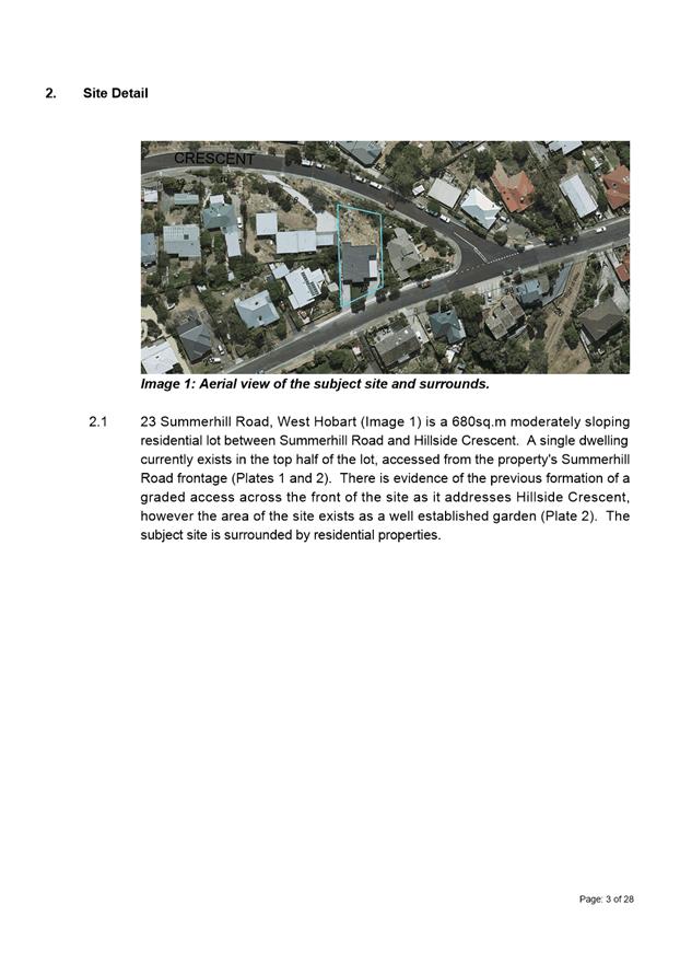
7.1.5 23 Summerhill Road, West Hobart and Adjacent Road Reserve, Two Multiple Dwellings (One Existing, One New)
Address: 23 Summerhill Road, West Hobart and Adjacent Road Reserve
Proposal: Two Multiple Dwellings (One Existing, One New)
Expiry Date: 2 November 2020
Extension of Time: Not applicable
Author: Cameron Sherriff
|
REcommendation That pursuant to the Hobart Interim Planning Scheme 2015, the City Planning Committee, in accordance with the delegations contained in its terms of reference, approve the application for two multiple dwellings (one existing, one new) at 23 Summerhill Road, WEST HOBART for the reasons outlined in the officer’s report and a permit containing the following conditions be issued:
GEN
The use and/or development must be substantially in accordance with the documents and drawings that comprise PLN20148 23 SUMMERHILL ROAD WEST HOBART TAS 7000 Final Planning Documents except where modified below.
Reason for condition
To clarify the scope of the permit.
TW
The use and/or development must comply with the requirements of TasWater as detailed in the form Submission to Planning Authority Notice, Reference No. TWDA 2020/00463HCC dated 25/08/2020 as attached to the permit.
Reason for condition
To clarify the scope of the permit.
ENG sw1
All stormwater from the proposed development (including but not limited to: roofed areas, ag drains, retaining wall ag drains and impervious surfaces such as driveways and paved areas) must be drained to the Council’s stormwater infrastructure prior first occupation of Unit 2 or commencement of use (whichever occurs first).
Advice:
Under section 23 of the Urban Drainage Act 2013 it is an offence for a property owner to direct stormwater onto a neighbouring property.
Reason for condition
To ensure that stormwater from the site will be discharged to a suitable Council approved outlet.
ENG sw4
Any new stormwater connection must be constructed and existing abandoned connections sealed by the Council at the owner’s expense, prior to the first occupation of Unit 2 or commencement of use (whichever occurs first).
Detailed engineering drawings must be submitted and approved, prior commencement of works. The detailed engineering drawings must include:
1. the location of the proposed connection; 2. the size of the connection appropriate to satisfy the needs of the development; 3. the material of the proposed stormwater connection; and 4. the interface between Council and private infrastructure.
All work required by this condition must be undertaken in accordance with the approved detailed engineering drawings.
Advice:
The applicant is advised to submit detailed design drawings via a Council City Amenity Division application for a new stormwater connection. If detailed design to satisfy this condition is submitted via the planning condition endorsement process there may be fees associated with the assessment, and once approved the applicant will still need to submit an application for a new stormwater connection with Council City Amenity Division.
Where building / plumbing approval is also required, it is recommended that documentation to satisfy this condition is submitted well before submitting documentation for building/plumbing approval. Failure to address planning condition requirements prior to submitting for building/plumbing approval may result in unexpected delays.
Reason for condition
To ensure the site is drained adequately.
ENG sw6
All stormwater from the proposed development (including hardstand runoff) must be discharged to the Council’s stormwater infrastructure with sufficient receiving capacity prior to first occupation of Unit 2 or commencement of use (whichever occurs first). All costs associated with works required by this condition are to be met by the owner.
Design drawings and calculations of the proposed stormwater drainage and connections to the Council's stormwater infrastructure must be submitted and approved prior to the commencement of work. The design drawings and calculations must:
1. prepared by a suitably qualified person; and 2. include long section(s)/levels and grades to the point of discharge.
All work required by this condition must be undertaken in accordance with the approved design drawings and calculations.
Advice:
The applicant is advised to submit detailed design drawings and calculations as part of their plumbing permit application. If detailed design to satisfy this condition is submitted via the planning condition endorsement process there may be fees associated with the assessment, and once approved the applicant will still need to obtain a plumbing permit for the works.
Reason for condition
To ensure that stormwater from the site will be discharged to a suitable Council approved outlet.
ENG 2a
Prior to first occupation of Unit 2 or commencement of use (whichever occurs first), vehicular barriers compliant with the Australian Standard AS/NZS1170.1:2002 must be installed to prevent vehicles running off the edge of an access driveway or parking module (parking spaces, aisles and manoeuvring area) where the drop from the edge of the trafficable area to a lower level is 600mm or greater, and wheel stops (kerb) must be installed for drops between 150mm and 600mm. Barriers must not limit the width of the driveway access or parking and turning areas approved under the permit.
Advice:
The Council does not consider a slope greater than 1 in 4 to constitute a lower level as described in AS/NZS 2890.1:2004 Section 2.4.5.3. Slopes greater than 1 in 4 will require a vehicular barrier or wheel stop.
Designers are advised to consult the National Construction Code 2016 to determine if pedestrian handrails or safety barriers compliant with the NCC2016 are also required in the parking module this area may be considered as a path of access to a building.
Reason for condition
To ensure the safety of users of the access driveway and parking module and compliance with the standard.
ENG 3a
Prior to the first occupation of Unit 2 or commencement of use (whichever occurs first), the access driveway, and parking module (parking spaces, aisles and manoeuvring area) must be designed and constructed in accordance with Australian Standard AS/NZS 2890.1:2004 (including the requirement for vehicle safety barriers where required), or a Council approved alternate design certified by a suitably qualified engineer to provide a safe and efficient access, and enable safe, easy and efficient use.
Advice:
It is advised that designers consider the detailed design of the access and parking module prior to finalising the Finished Floor Level (FFL) of the parking spaces (especially if located within a garage incorporated into the dwelling), as failure to do so may result in difficulty complying with this condition.
Reason for condition
To ensure the safety of users of the access and parking module, and compliance with the relevant Australian Standard.
ENG 3b
The access driveway, and parking module (parking spaces, aisles and manoeuvring area) design must be submitted and approved, prior to the issuing of any approval under the Building Act 2016.
The access driveway, and parking module (parking spaces, aisles and manoeuvring area) design must:
1. Be prepared and certified by a suitably qualified engineer; 2. Be generally in accordance with the Australian Standard AS/NZS2890.1:2004; 3. Where the design deviates from AS/NZS2890.1:2004 the designer must demonstrate that the design will provide a safe and efficient access, and enable safe, easy and efficient use; and 4. Show dimensions, levels, gradients and transitions, and other details as Council deem necessary to satisfy the above requirement.
Advice:
It is advised that designers consider the detailed design of the access and parking module prior to finalising the Finished Floor Level (FFL) of the parking spaces (especially if located within a garage incorporated into the dwelling), as failure to do so may result in difficulty complying with this condition.
Once the design has been approved, the Council will issue a condition endorsement (see general advice on how to obtain condition endorsement)
Where building approval is also required, it is recommended that documentation for condition endorsement be submitted well before submitting documentation for building approval. Failure to address condition endorsement requirements prior to submitting for building approval may result in unexpected delays.
Reason for condition
To ensure the safety of users of the access and parking module, and compliance with the relevant Australian Standard.
ENG 3c
The access driveway, and parking module (parking spaces, aisles and manoeuvring area) must be constructed in accordance with the design drawings approved by conditions ENG 3b, ENG r1 and ENG r3.
Prior to the first occupation of Unit 2 or commencement of use (whichever occurs first), documentation by a suitably qualified engineer certifying that the access driveway and parking module has been constructed in accordance with the above drawings must be lodged with the Council.
Advice:
Certification may be submitted to the Council as part of the Building Act 2016 approval process or via condition endorsement (see general advice on how to obtain condition endorsement)
Reason for condition
To ensure the safety of users of the access and parking module, and compliance with the relevant Australian Standard.
ENG 4
The access driveway and parking module (car parking spaces, aisles and manoeuvring area) approved by this permit must be constructed to a sealed standard (spray seal, asphalt, concrete, pavers or equivalent Council approved) and surface drained to the Council's stormwater infrastructure prior to the first occupation of Unit 2 or the commencement of use (whichever occurs first).
Reason for condition
To ensure the safety of users of the access driveway and parking module, and that it does not detract from the amenity of users, adjoining occupiers or the environment by preventing dust, mud and sediment transport.
ENG 1
Any damage to council infrastructure resulting from the implementation of this permit, must, at the discretion of the Council:
1. Be met by the owner by way of reimbursement (cost of repair and reinstatement to be paid by the owner to the Council); or 2. Be repaired and reinstated by the owner to the satisfaction of the Council.
A photographic record of the Council's infrastructure adjacent to the subject site must be provided to the Council prior to any commencement of works.
A photographic record of the Council’s infrastructure (e.g. existing property service connection points, roads, buildings, stormwater, footpaths, driveway crossovers and nature strips, including if any, preexisting damage) will be relied upon to establish the extent of damage caused to the Council’s infrastructure during construction. In the event that the owner/developer fails to provide to the Council a photographic record of the Council’s infrastructure, then any damage to the Council's infrastructure found on completion of works will be deemed to be the responsibility of the owner.
Reason for condition
To ensure that any of the Council's infrastructure and/or siterelated service connections affected by the proposal will be altered and/or reinstated at the owner’s full cost.
ENG r1
The excavation and earthretaining structures (ie embankments, cuttings, retaining walls) within or supporting the highway reservation must not undermine the stability and integrity of the highway reservation and its infrastructure.
Detailed design drawings, structural certificates and associated geotechnical assessments of the retaining wall within the Hillside Crescent highway reservation must be submitted and approved, prior to issuing of any approval under the Building Act 2016 and must:
1. Be prepared and certified by a suitable qualified person and experienced engineer. 2. Not undermine the stability of the highway reservation. 3. Be designed in accordance with AS 4678, with a design life in accordance with table 3.1 typical application major public infrastructure works. 4. Take into account any additional surcharge loadings as required by relevant Australian Standards. 5. Take into account and reference accordingly any Geotechnical findings. 6. Detail any mitigation measures required. 7. The structure certificated and/or drawings should note accordingly the above.
All work required by this condition must be undertaken in accordance with the approved select design drawing and structural certificates.
Advice:
The applicant is required submit detailed design documentation to satisfy this condition via Council's planning condition endorsement process (noting there is a fee associated with condition endorsement approval of engineering drawings [see general advice on how to obtain condition endorsement and for fees and charges]). This is a separate process to any building approval under the Building Act 2016.
Failure to address condition endorsement requirements prior to submitting for building approval may result in unexpected delays.
You are likely to require a Permit to Open Up and Temporarily Occupy a Highway (for work within the highway reservation). Click here for more information.
Reason for condition
To ensure that the stability and integrity of the Council’s highway reservation is not compromised by the development.
ENG r3
Prior to the first occupation of Unit 2 or commencement of use (whichever occurs first), the proposed driveway crossover within the Hillside Crescent highway reservation must be designed and constructed in accordance with:
· Urban TSDR09v1 – Urban Roads Driveways and TSD R14v1 Type KC vehicular crossing · Footpath Urban Roads Footpaths TSDR11v1 · or a Council City Amenity Division approved alternate design
Design drawings must be submitted and approved prior to any approval under the Building Act 2016. The design drawing must:
1. Show the cross and long section of the driveway crossover within the highway reservation and onto the property. 2. Detail any services or infrastructure (ie light poles, pits, awnings) at or near the proposed driveway crossover. 3. Be designed for the expected vehicle loadings. A structural certificate to note that driveway is suitable for heavy vehicle loadings. 4. Be prepared and certified by a suitable qualified person, to satisfy the above requirement.
All work required by this condition must be undertaken in accordance with the approved drawings.
Advice:
The applicant is required submit detailed design documentation to satisfy this condition via Council's planning condition endorsement process (noting there is a fee associated with condition endorsement approval of engineering drawings [see general advice on how to obtain condition endorsement and for fees and charges]). This is a separate process to any building approval under the Building Act 2016.
Please note that your proposal does not include adjustment of footpath levels. Any adjustment to footpath levels necessary to suit the design of proposed floor, parking module or driveway levels will require separate agreement from Council's Road Services Engineer and may require further planning approvals. It is advised to place a note to this affect on construction drawings or the site and/or other relevant engineering drawings to ensure that contractors are made aware of this requirement.
Failure to address condition endorsement requirements prior to submitting for building approval may result in unexpected delays.
Please contact the Council’s City Amenity Division to discuss approval of alternate designs.
You are likely to require a Permit to Open Up and Temporarily Occupy a Highway (for work within the highway reservation). Click here for more information.
Reason for condition
To ensure that works will comply with the Council’s standard requirements.
ENG r4
Vehicle crash barriers with the Hillside Crescent highway reservation compliant with the Australian/New Zealand Standard AS / NZS 1170.1 and/or the (IPWEA) LGAT –Tasmanian Standard Drawings must be installed or modified as per the plans prior to the first occupation of Unit 2 or commencement of use (whichever occurs first).
A certified design/report prepared by a suitably qualified engineer, to satisfy the above requirements, must be provided to the Council prior to the issuing of any approval under the Building Act 2016.
All works, required by this condition must be undertaken in accordance with certified design/report. Upon completion the barriers must be inspected by a qualified engineer and a certification submitted to the Council, confirming that the installed barriers comply with the above requirement.
Advice:
The applicant is required submit detailed design/report documentation to satisfy this condition via Council's planning condition endorsement process (noting there is a fee associated with condition endorsement approval of engineering drawings [see general advice on how to obtain condition endorsement and for fees and charges]). This is a separate process to any building approval under the Building Act 2016.
Failure to address condition endorsement requirements prior to submitting for building approval may result in unexpected delays.
Upon completion of the barriers the certification that the installed barriers comply with the relevant requirements may be submitted to Council as part of the Building Act 2016 approval process or via condition endorsement (see general advice on how to obtain condition endorsement).
You are likely to require a Permit to Open Up and Temporarily Occupy a Highway (for work within the highway reservation). Click here for more information.
Reason for condition
To ensure that the safety of users of the driveway/parking and compliance with the standard.
ENV 1
Sediment and erosion control measures sufficient to prevent sediment from leaving the site must be installed prior to any disturbance of the site, and maintained until all areas of disturbance have been stabilized or revegetated.
Advice:
For further guidance in preparing a Soil and Water Management Plan – in accordance with Fact sheet 3 Derwent Estuary Program click here.
Reason for condition
To avoid the sedimentation of roads, drains, natural watercourses, Council land that could be caused by erosion and runoff from the development, and to comply with relevant State legislation.
ADVICE
The following advice is provided to you to assist in the implementation of the planning permit that has been issued subject to the conditions above. The advice is not exhaustive and you must inform yourself of any other legislation, bylaws, regulations, codes or standards that will apply to your development under which you may need to obtain an approval. Visit the Council's website for further information.
Prior to any commencement of work on the site or commencement of use the following additional permits/approval may be required from the Hobart City Council.
CONDITION ENDORSEMENT ENGINEERING
All engineering drawings required to be submitted and approved by this planning permit must be submitted to the City of Hobart as a CEP (Condition Endorsement) via the City’s Online Service Development Portal. When lodging a CEP, please reference the PLN number of the associated Planning Application. Each CEP must also include an estimation of the cost of works shown on the submitted engineering drawings. Once that estimation has been confirmed by the City’s Engineer, the following fees are payable for each CEP submitted and must be paid prior to the City of Hobart commencing assessment of the engineering drawings in each CEP:
Value of Building Works Approved by Planning Permit Fee:
Up to $20,000: $150 per application.
Over $20,000: 2% of the value of the works as assessed by the City's Engineer per assessment.
These fees are additional to building and plumbing fees charged under the Building and Plumbing Regulations.
Once the CEP is lodged via the Online Service Development Portal, if the value of building works approved by your planning permit is over $20,000, please contact the City’s Development Engineer on 6238 2715 to confirm the estimation of the cost of works shown on the submitted engineering drawings has been accepted.
Once confirmed, pleased call one of the City’s Customer Service Officers on 6238 2190 to make payment, quoting the reference number (ie. CEP number) of the Condition Endorsement you have lodged. Once payment is made, your engineering drawings will be assessed.
BUILDING PERMIT
You may need building approval in accordance with the Building Act 2016. Click here for more information.
This is a Discretionary Planning Permit issued in accordance with section 57 of the Land Use Planning and Approvals Act 1993.
PLUMBING PERMIT
You may need plumbing approval in accordance with the Building Act 2016, Building Regulations 2016 and the National Construction Code. Click here for more information.
OCCUPATION OF THE PUBLIC HIGHWAY
You may require a Permit to Open Up and Temporarily Occupy a Highway (for work in the road reserve). Click here for more information.
NEW SERVICE CONNECTION
Please contact the Hobart City Council's City Amenity Division to initiate the application process for your new stormwater connection.
STORMWATER
Please note that in addition to a building and/or plumbing permit, development must be in accordance with the Hobart City Council’s Infrastructure By law. Click here for more information.
WORK WITHIN THE HIGHWAY RESERVATION
Please note development must be in accordance with the Hobart City Council’s Infrastructure By law. Click here for more information.
DRIVEWAY SURFACING OVER HIGHWAY RESERVATION
If a coloured or textured surface is used for the driveway access within the Highway Reservation, the Council or other service provider will not match this on any reinstatement of the driveway access within the Highway Reservation required in the future.
FEES AND CHARGES
Click here for information on the Council's fees and charges.
DIAL BEFORE YOU DIG
Click here for dial before you dig information.
|
Attachment a: PLN-20-148
- 23 SUMMERHILL ROAD WEST HOBART TAS 7000 - Planning Committee or Delegated
Report ⇩ ![]()
Attachment
b: PLN-20-148
- 23 SUMMERHILL ROAD WEST HOBART TAS 7000 - CPC Agenda Documents (Supporting
information) ![]()
|
Item No. 7.1.5 |
Agenda (Open Portion) City Planning Committee Meeting - 19/10/2020 |
Page 186 ATTACHMENT a |
|
Agenda (Open Portion) City Planning Committee Meeting |
Page 193 |
|
|
|
19/10/2020 |
|
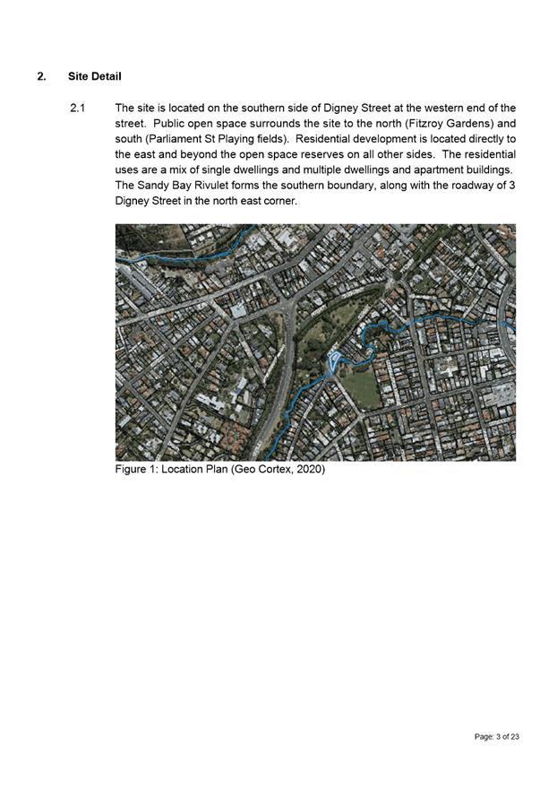
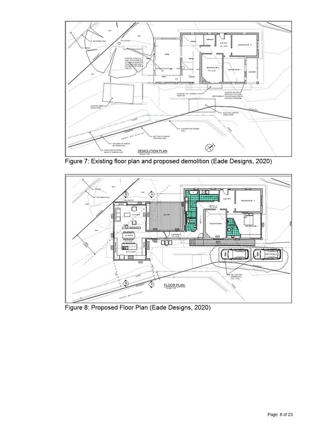
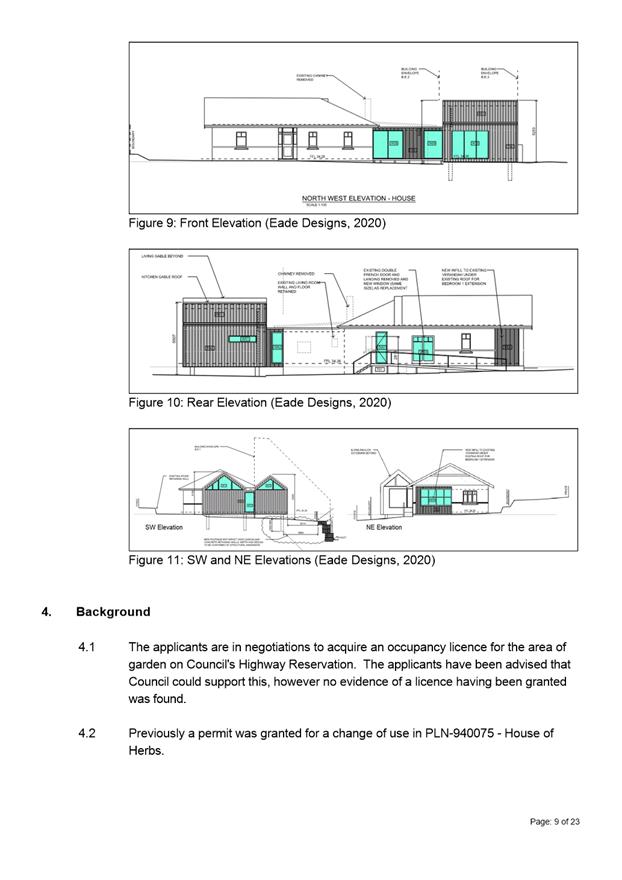
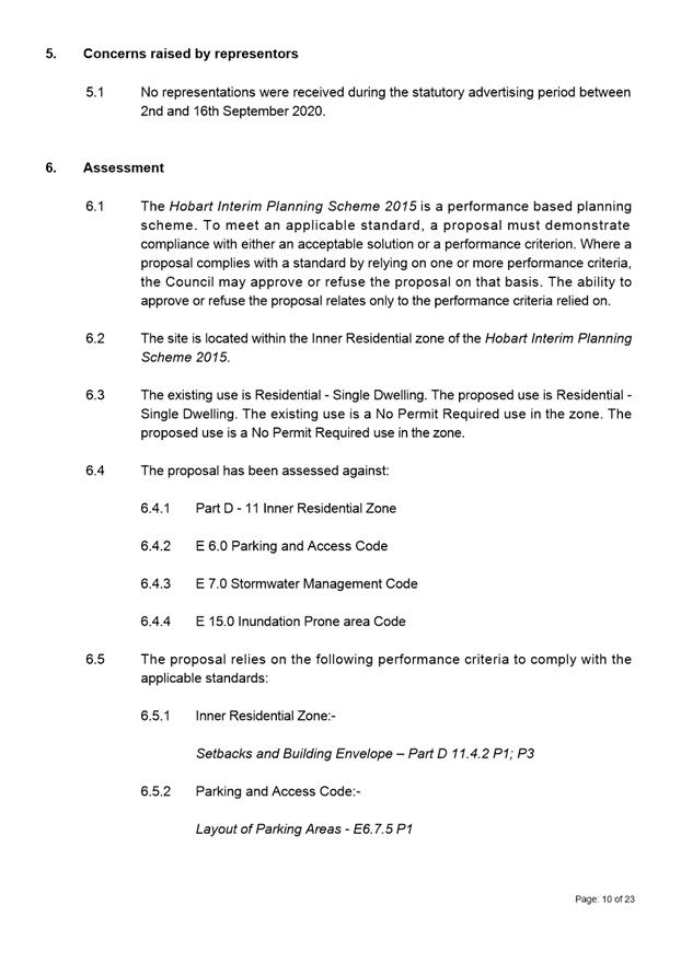
7.1.6 1 Digney Street and 3 Digney Street, Dynnyrne and Adjacent Rivulet - Partial Demolition, Alterations and Extension
Address: 1 Digney Street and 3 Digney Street, Dynnyrne and Adjacent Rivulet
Proposal: Partial Demolition, Alterations and Extension
Expiry Date: 2 November 2020
Extension of Time: Not applicable
Author: Victoria Maxwell
|
REcommendation That pursuant to the Hobart Interim Planning Scheme 2015, the City Planning Committee, in accordance with the delegations contained in its terms of reference, approve the application for partial demolition, alterations and extension at 1 DIGNEY STREET AND 3 DIGNEY STREET, DYNNYRNE TAS 7005 AND ADJACENT RIVULET for the reasons outlined in the officer’s report and a permit containing the following conditions be issued:
GEN
The use and/or development must be substantially in accordance with the documents and drawings that comprise PLN20429 1 DIGNEY STREET DYNNYRNE TAS 7005 Final Planning Documents except where modified below.
Reason for condition
To clarify the scope of the permit.
ENG sw1
All stormwater from the proposed development (including but not limited to: roofed areas, ag drains, retaining wall ag drains and impervious surfaces such as driveways and paved areas) must be drained to the Council’s stormwater infrastructure prior to first occupation or commencement of use (whichever occurs first).
Reason for condition
To ensure that stormwater from the site will be discharged to a suitable Council approved outlet.
ENG 1
Any damage to council infrastructure resulting from the implementation of this permit, must, at the discretion of the Council:
1. Be met by the owner by way of reimbursement (cost of repair and reinstatement to be paid by the owner to the Council); or 2. Be repaired and reinstated by the owner to the satisfaction of the Council.
A photographic record of the Council's infrastructure adjacent to the subject site must be provided to the Council prior to any commencement of works.
A photographic record of the Council’s infrastructure (e.g. existing property service connection points, roads, buildings, stormwater, footpaths, driveway crossovers and nature strips, including if any, preexisting damage) will be relied upon to establish the extent of damage caused to the Council’s infrastructure during construction. In the event that the owner/developer fails to provide to the Council a photographic record of the Council’s infrastructure, then any damage to the Council's infrastructure found on completion of works will be deemed to be the responsibility of the owner.
Reason for condition
To ensure that any of the Council's infrastructure and/or siterelated service connections affected by the proposal will be altered and/or reinstated at the owner’s full cost.
ENG s1
The stormwater floodway along the western side boundary of the property must be retained.
Detailed design of the works in the floodway (including but not limited to footing and walls) demonstrating that overland flows will minimise the impedance of flow must be submitted and approved prior to issue of any consent under the Building Act 2016. The detailed design must include:
· Certification from an accredited and qualified structural engineer that all proposed structures within the flood zone are designed to resist inundation, erosion, undermining and likely forces from a flood event.
· Drawings of the works within the floodway in accordance with the Stormwater Inundation report by Flussig (dated 13 July 2020 and forming part of the Final Planning Documents).
All works required by this condition must be undertaken in accordance with the approved detailed design.
Reason for condition
To ensure that the risks associated with building in a flood zone and near Council's stormwater infrastructure are managed.
ENV 2
Sediment and erosion control measures, in accordance with an approved soil and water management plan (SWMP), must be installed prior to the commencement of work and maintained until such time as all disturbed areas have been stabilised and/or restored or sealed to the Council’s satisfaction.
A SWMP must be submitted prior to the issue of any approval under the Building Act 2016 or the commencement of work, whichever occurs first. The SWMP must be prepared in accordance with the Soil and Water Management on Building and Construction Sites fact sheets (Derwent Estuary Program, 2008), available here.
All work required by this condition must be undertaken in accordance with the approved SWMP.
Advice:
Once the SWMP has been approved, the Council will issue a condition endorsement (see general advice on how to obtain condition endorsement).
Where building approval is also required, it is recommended that documentation for condition endorsement be submitted well before submitting documentation for building approval. Failure to address condition endorsement requirements prior to submitting for building approval may result in unexpected delays.
Reason for condition
To avoid the pollution and sedimentation of roads, drains and natural watercourses that could be caused by erosion and runoff from the development.
ENV s1
The void space shown between the underside of the extension floor and the ground as shown in the submitted plans must be established and maintained for the life of the extension. The void must be kept open and free from obstructions for the life of the extension.
Reason for condition
To ensure the development does not unreasonably increase the risk from flooding.
OPS 1
The title boundary shared between the Council's Highway Reserve, 3 Digney Street Right of Way, the Sandy Bay Rivulet and the subject property must be remarked by a registered Land Surveyor and clearly marked on the ground prior to commencement of works on site. All works (excluding the demolition of the car port) must only be undertaken within the subject property.
Reason for condition
To ensure development is contained within the subject private property.
ADVICE
The following advice is provided to you to assist in the implementation of the planning permit that has been issued subject to the conditions above. The advice is not exhaustive and you must inform yourself of any other legislation, bylaws, regulations, codes or standards that will apply to your development under which you may need to obtain an approval. Visit the Council's website for further information.
Prior to any commencement of work on the site or commencement of use the following additional permits/approval may be required from the Hobart City Council.
BUILDING PERMIT
You may need building approval in accordance with the Building Act 2016. Click here for more information.
This is a Discretionary Planning Permit issued in accordance with section 57 of the Land Use Planning and Approvals Act 1993.
PLUMBING PERMIT
You may need plumbing approval in accordance with the Building Act 2016, Building Regulations 2016 and the National Construction Code. Click here for more information.
OCCUPATION OF THE PUBLIC HIGHWAY
You may require an occupational licence for use of Hobart City Council highway reservation (e.g. outdoor seating, etc). Click here for more information.
NEW SERVICE CONNECTION
Please contact the Hobart City Council's City Amenity Division to initiate the application process for your new stormwater connection.
HABITABLE ROOM FLOOR LEVELS
The applicant is advised that s159 of the Building Act 2000 (and s3(2) of the Building Regulations 2016) states:
A person must not erect or place a building containing habitable rooms on land subject to flooding unless the floor level of each habitable room in the building is 300 millimetres or more above the prescribed designated flood level for that land.
From current plans, it appears that the proposed floor level does not meet this.
Therefore the floor level may need to be raised in the building application. Please be advised that an amendment to this permit will be required and no guarantee is given at this point that approval of such will be forthcoming.
STORMWATER
Please note that in addition to a building and/or plumbing permit, development must be in accordance with the Hobart City Council’s Infrastructure By law. Click here for more information.
STORMWATER / ROADS / ACCESS
Services to be designed and constructed in accordance with the (IPWEA) LGAT – standard drawings. Click here for more information.
RIGHT OF WAY
The private right of way must not be reduced, restricted or impeded in any way, and all beneficiaries must have complete and unrestricted access at all times.
You should inform yourself as to your rights and responsibilities in respect to the private right of way particularly reducing, restricting or impeding the right during and after construction.
NOISE REGULATIONS
Click here for information with respect to noise nuisances in residential areas.
FEES AND CHARGES
Click here for information on the Council's fees and charges.
DIAL BEFORE YOU DIG
Click here for dial before you dig information.
|
Attachment a: PLN-20-429
- 1 DIGNEY STREET DYNNYRNE TAS 7005 - Planning Committee or Delegated Report ⇩ ![]()
Attachment
b: PLN-20-429
1 DIGNEY STREET DYNNYRNE TAS 7005 - CPC Agenda Documents (Supporting
information) ![]()
|
Item No. 7.1.6 |
Agenda (Open Portion) City Planning Committee Meeting - 19/10/2020 |
Page 216 ATTACHMENT a |

|
Agenda (Open Portion) City Planning Committee Meeting |
Page 219 |
|
|
|
19/10/2020 |
|
7.1.7 19 Allison Street, West Hobart - Partial Demolition and Alterations
Address: 19 Allison Street, West Hobart
Proposal: Partial Demolition and Alterations
Expiry Date: 20 November 2020
Extension of Time: Not applicable
Author: Cameron Sherriff
|
REcommendation That pursuant to the Hobart Interim Planning Scheme 2015, the City Planning Committee, in accordance with the delegations contained in its terms of reference, approve the application for partial demolition and alterations at 19 Allison Street, WEST HOBART for the reasons outlined in the officer’s report and a permit containing the following conditions be issued:
GEN
The use and/or development must be substantially in accordance with the documents and drawings that comprise PLN20550 19 ALLISON STREET WEST HOBART TAS 7000 Final Planning Documents except where modified below.
Reason for condition
To clarify the scope of the permit.
PLN 1
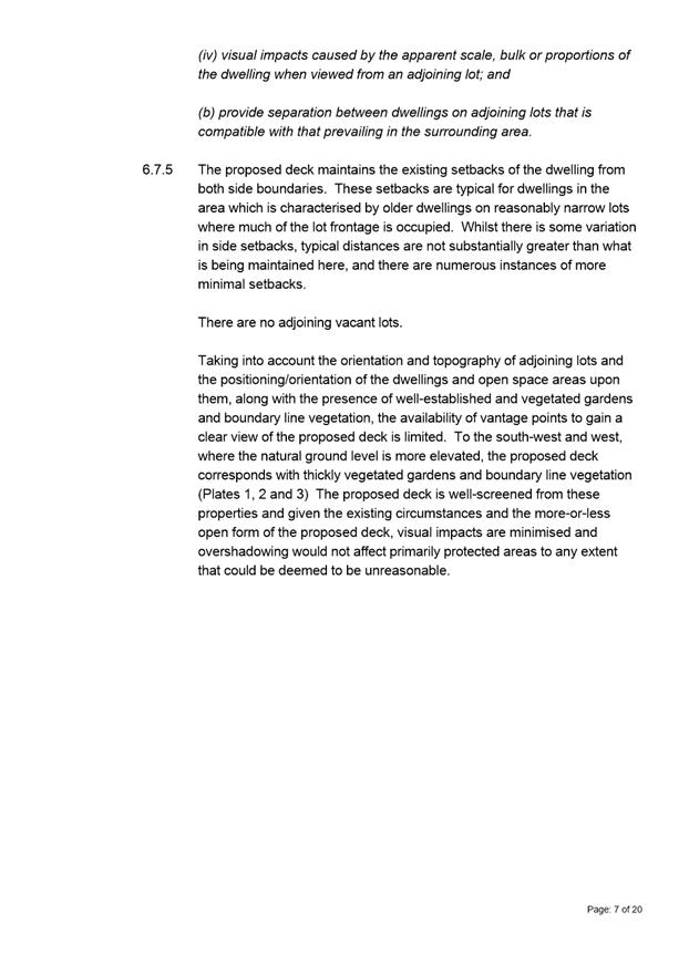
Screening to a height above deck surface level equivalent to that of the rear end of the skillion roof section on the back of the adjacent dwelling at 17 Allison Street, with no more than 25% uniform transparency must be installed and maintained along that part of the northeastern edge of the deck for a length equivalent to the current northeastern end of the existing deck prior to first occupation.
Prior to the issue of any approval under the Building Act 2016, revised plans must be submitted and approved showing screening in accordance with the above requirement.
All work required by this condition must be undertaken in accordance with the approved revised plans.
Reason for condition
To provide reasonable opportunity for privacy for dwellings.
ADVICE
The following advice is provided to you to assist in the implementation of the planning permit that has been issued subject to the conditions above. The advice is not exhaustive and you must inform yourself of any other legislation, bylaws, regulations, codes or standards that will apply to your development under which you may need to obtain an approval. Visit the Council's website for further information.
Prior to any commencement of work on the site or commencement of use the following additional permits/approval may be required from the Hobart City Council.
BUILDING PERMIT
You may need building approval in accordance with the Building Act 2016. Click here for more information.
This is a Discretionary Planning Permit issued in accordance with section 57 of the Land Use Planning and Approvals Act 1993.
WASTE DISPOSAL
It is recommended that the developer liaise with the Council’s Cleansing and Solid Waste Unit regarding reducing, reusing and recycling materials associated with demolition on the site to minimise solid waste being directed to landfill.
Further information regarding waste disposal can also be found on the Council’s website.
|
Attachment a: PLN-20-550
- 19 ALLISON STREET WEST HOBART TAS 7000 - Planning Committee or Delegated
Report ⇩ ![]()
Attachment
b: PLN-20-550
- 19 ALLISON STREET WEST HOBART TAS 7000 - CPC Agenda Documents (Supporting
information) ![]()
Attachment
c: PLN-20-550
- 19 ALLISON STREET WEST HOBART TAS 7000 - Planning Referral Officer Cultural
Heritage Report (Supporting information) ![]()
|
Item No. 7.1.7 |
Agenda (Open Portion) City Planning Committee Meeting - 19/10/2020 |
Page 239 ATTACHMENT a |
|
Agenda (Open Portion) City Planning Committee Meeting |
Page 240 |
|
|
|
19/10/2020 |
|
8. Reports
8.1 Amendment PSA-18-2 - Hobart Interim Planning Scheme 2015 - 66 Summerhill Road Rezoning
Report of the Development Planner and the Director City Planning of 13 October 2020 and attachments.
Delegation: Council
|
Item No. 8.1 |
Agenda (Open Portion) City Planning Committee Meeting |
Page 263 |
|
|
19/10/2020 |
|
REPORT TITLE: Amendment PSA-18-2 - Hobart Interim Planning Scheme 2015 - 66 Summerhill Road Rezoning
REPORT PROVIDED BY: Development Planner
Director City Planning
1. Report Purpose and Community Benefit
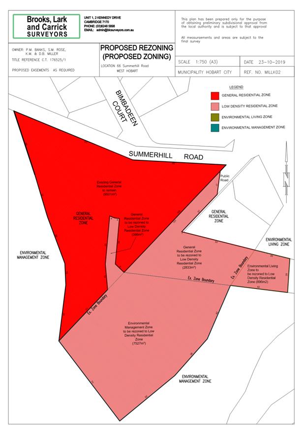
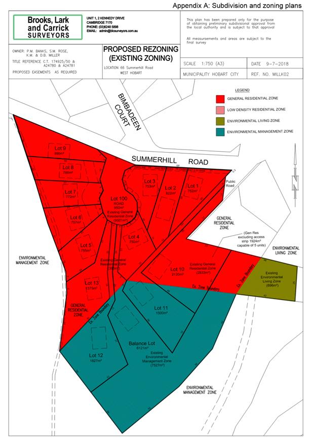
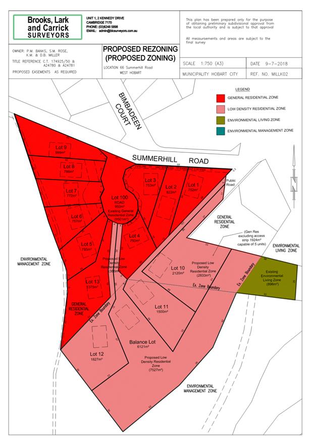
1.1. The purpose of this report is to consider an application under the former provisions of the Land Use Planning and Approvals Act 1993 (LUPAA), from ERA Planning on behalf of Newdegate Nominees Pty Ltd, to amend the Hobart Interim Planning Scheme 2015 (HIPS 2015) by rezoning the property at 66 Summerhill Road to Low Density Residential from Environmental Management, Environmental Living and General Residential. The amendment is described in the applicant’s rezoning plan and accompanying submission in Attachments A and B.
1.2. The Biodiversity Protection Area overlay is also proposed to be extended across the entire area rezoned to Low Density Residential.
1.3. As requested by the applicant, this report also recommends the initiation of an amendment to the Southern Tasmania Regional Land Use Strategy 2010-2035 (STRLUS) to amend the Urban Growth Boundary (UGB) to allow for the rezoning to occur.
1.4. The proposal benefits the community by ensuring that land is appropriately zoned and that use and development is undertaken in a fair and orderly manner.
2. Report Summary
2.1. The proposal is to rezone 66 Summerhill Road (title reference: CT 178330/1) to Low Density Residential. The site is currently zoned General Residential, Environmental Management and Environmental Living.
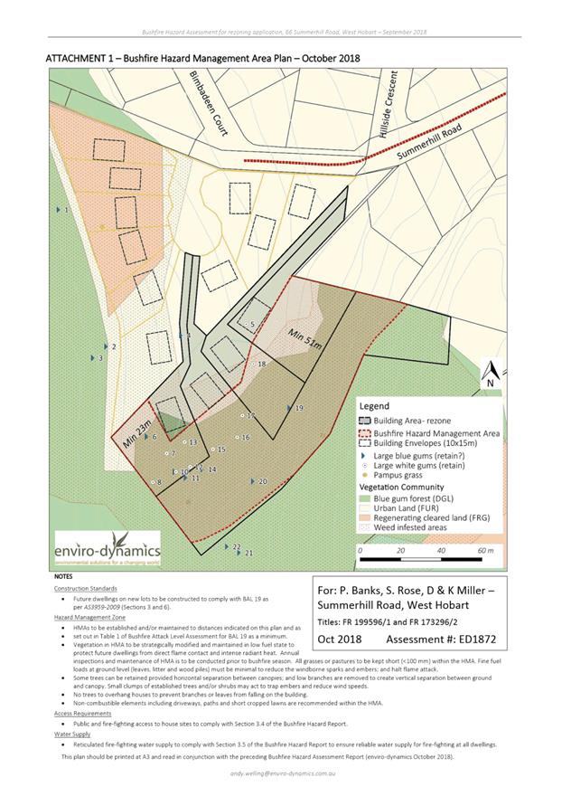
2.2. The proposed rezoning plan is provided as Attachment A.
2.3. The applicant’s supporting documentation relating to the rezoning is provided as Attachment B.
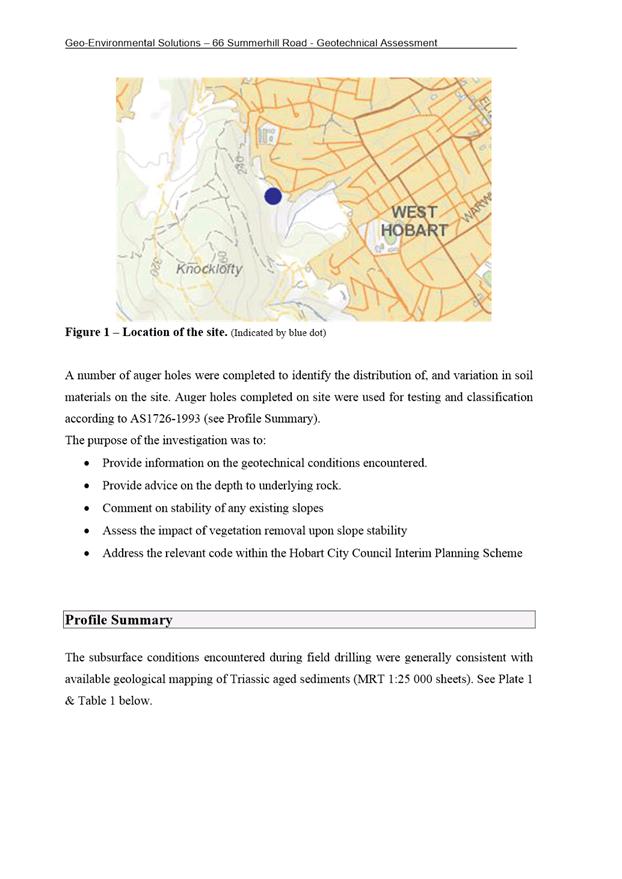
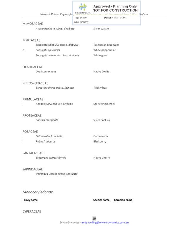
2.4. The site is located on the fringe of existing residential development at the end of Summerhill Road in West Hobart, and adjoins the City-owned Knocklofty Reserve.
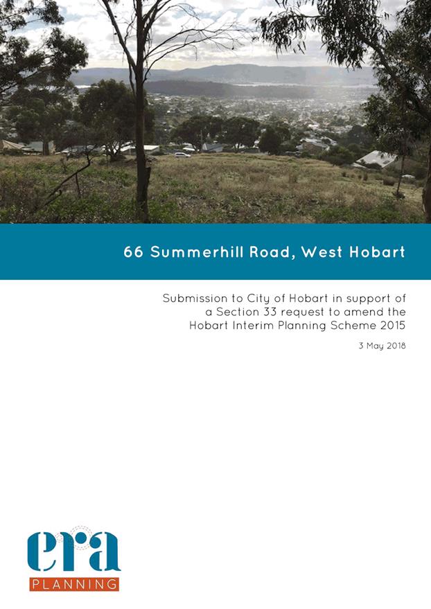
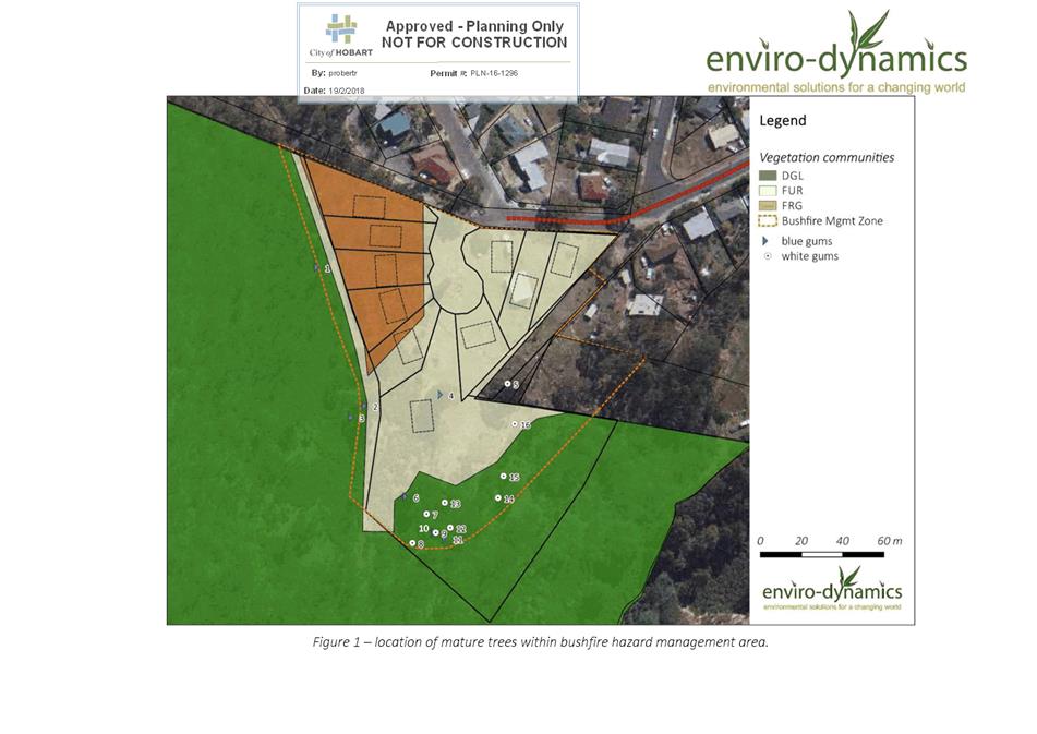
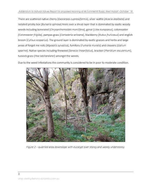
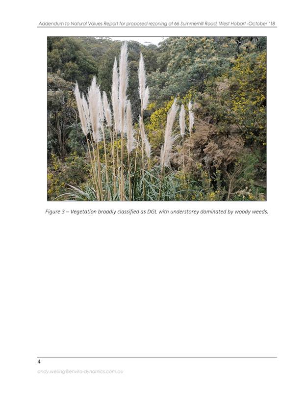
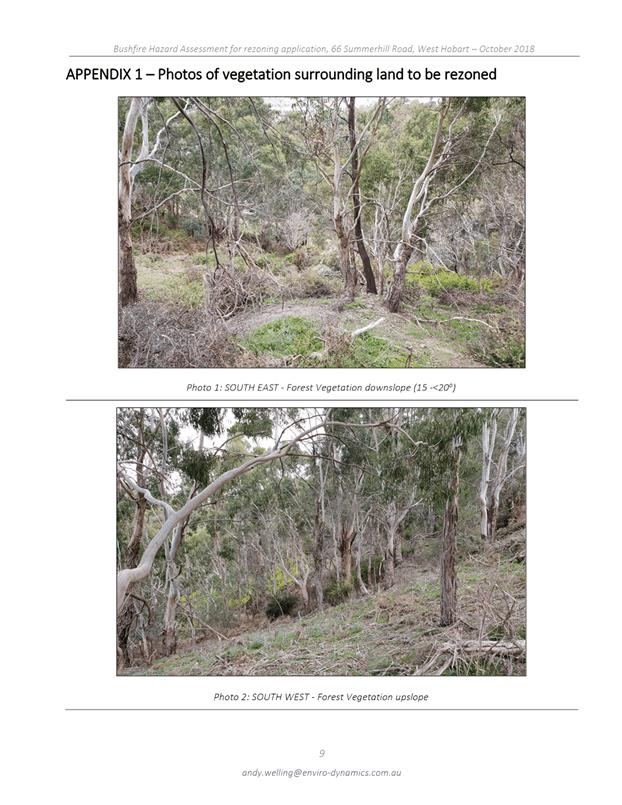
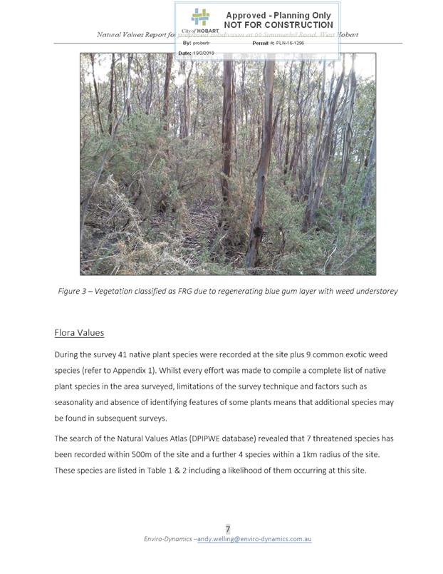
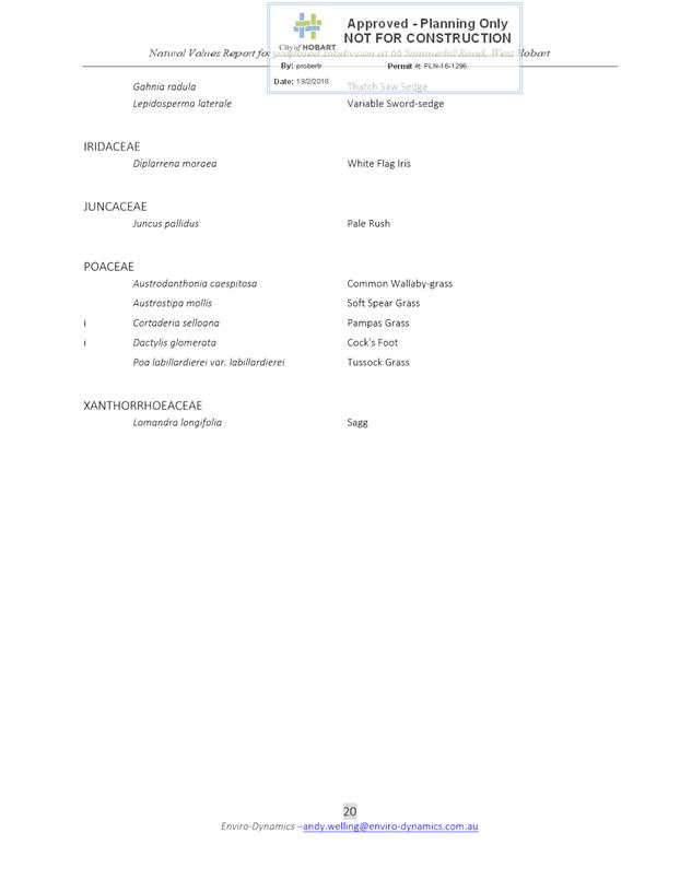
2.5. The land is generally east facing and partly vegetated. The dominant vegetation type is Eucalyptus globulus dry forest and woodland, although it is significantly weed infested.
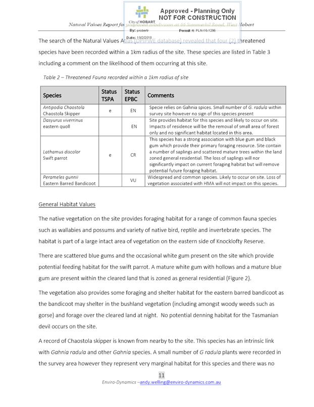
2.6. The subject site comprises part of the balance lot of a previous subdivision for 9 lots plus balance at 66 Summerhill Road (PLN-16-1296).
2.7. Council purchased some of this balance lot following the subdivision to formalise existing informal use of the area by the public and provide a strategic link between the southern and northern parts of Knocklofty Reserve.
2.8. Submitted documentation demonstrates that the land subject to the rezoning is capable of being developed to a density commensurate with the Low Density Residential Zone.
2.9. In order for the rezoning to occur, the Urban Growth Boundary (UGB) of the Southern Tasmania Regional Land Use Strategy 2010-2035 (STRLUS) will need to be extended.
2.10. The applicant has also requested that Council initiate an amendment to the STRLUS. Justification for this change is provided as Attachment C.
2.11. It is considered that both the proposed rezoning and the amendment to the STRLUS are capable of meeting the requirements of LUPAA for the following reasons:
2.11.1. The land is not considered to be suitable for retention under the Environmental Management Zone given it does not contain high conservation value vegetation;
2.11.2. The Low Density Residential Zone provides for a transition in residential density between the adjacent General Residential Zone and neighbouring Council-owned Knocklofty Reserve;
2.11.3. The development potential following the rezoning is not significantly different in terms of number of permitted dwellings compared to the existing situation;
2.11.4. The rezoning is not considered to increase potential for land use conflicts considering surrounding land uses and the likely location and number of future dwellings.
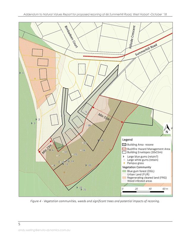
2.12. It is recommended that the Biodiversity Protection Area Overlay should be extended across the entire rezoned area, in order to consider existing vegetation at the development stage and to protect a significantly old, large, hollow-bearing white gum.
2.13. The proposed amendment is recommended for initiation, and it is recommended that a letter be sent to the Minister for Planning to request a STRLUS amendment to extend the UGB.
|
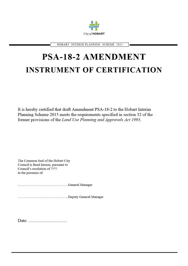
That: 1. Pursuant to Section 34(1) (a) of the former provisions of the Land Use Planning and Approvals Act 1993, the Council resolve to initiate an amendment to the Hobart Interim Planning Scheme 2015 to rezone the property at 66 Summerhill Road to Low Density Residential from General Residential, Environmental Living and Environmental Management, as indicated in the rezoning plan provided in Attachment A, and to extend the Biodiversity Protection Area Overlay over the entire area rezoned to Low Density Residential. 2. Pursuant to Section 35 of the former provisions of the Land Use Planning and Approvals Act 1993, the Council certify that the amendment to the Hobart Interim Planning Scheme 2015 PSA-18-2 meets the requirements of Section 32 of the former provisions of the Land Use Planning and Approvals Act 1993 and authorise the General Manager and the Deputy General Manager to sign the Instrument of Certification (Attachment E). 3. Pursuant to Section 38 of the former provisions of the Land Use Planning and Approvals Act 1993, the Council place Amendment PSA-18-2 to the Hobart Interim Planning Scheme 2015 on public exhibition for a 28 day period following certification. 4. Council resolve to request the Minister for Planning to amend to the Southern Tasmania Regional Land Use Strategy 2010-2035 (STRLUS) to extend the Urban Growth Boundary to include the area of 66 Summerhill Road to be rezoned Low Density Residential.
|
4. Background
4.1. The land subject to the rezoning comprises part of the balance lot of a previous subdivision at 66 Summerhill Road (PLN-16-1296). This subdivision was for 9 lots plus balance.
4.2. Council purchased some of the balance lot following the subdivision to formalise existing informal use of the area by the public and provide a strategic link between the southern and northern parts of Knocklofty Reserve. The remainder of the balance lot is the subject of this application.
4.3. The ownership of the subject site has changed since the amendment request was submitted.
4.4. Since submission, a parcel of land acquired through an adverse possession claim has been adhered to the title for 66 Summerhill Road, and forms part of the proposal.
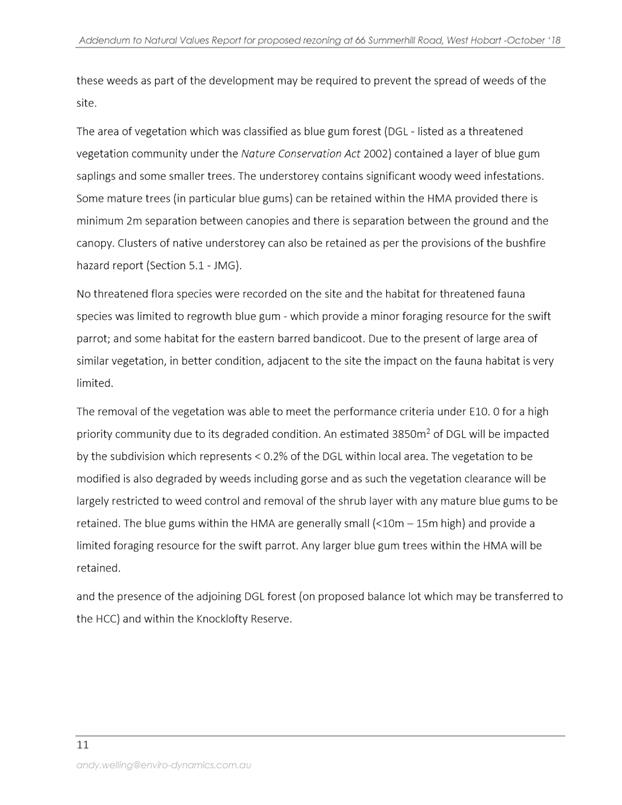
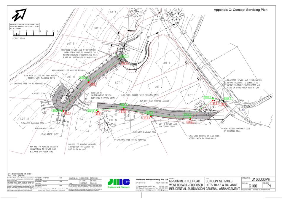
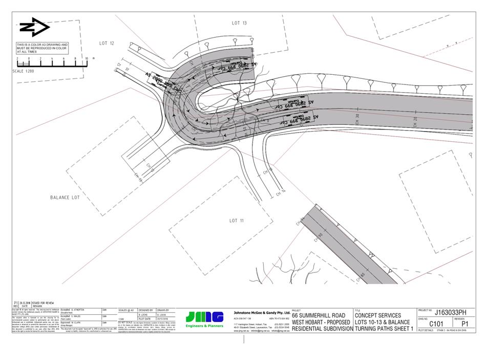
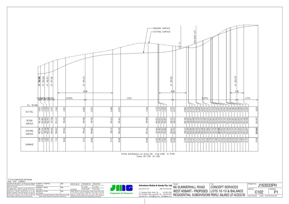
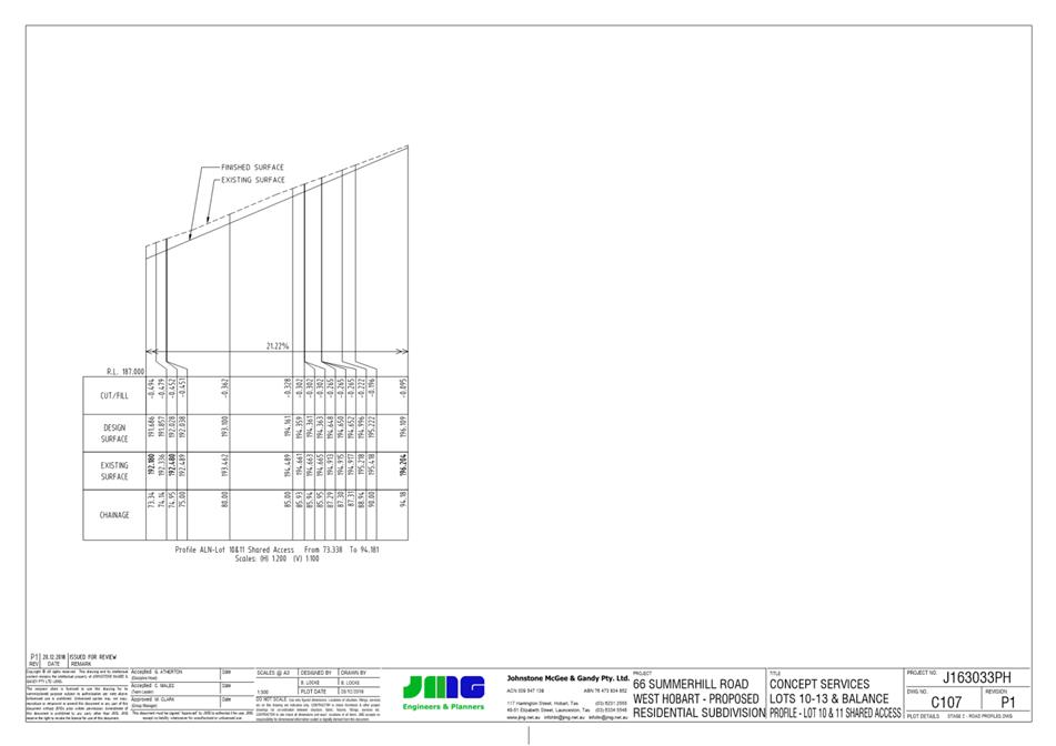
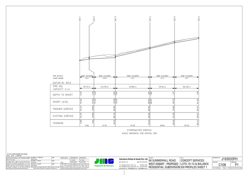
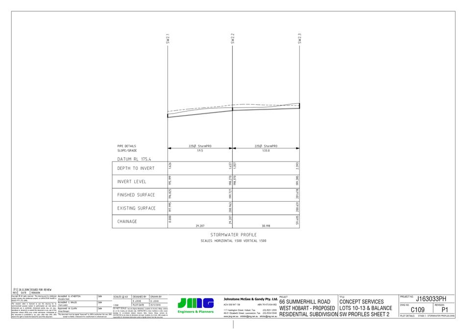
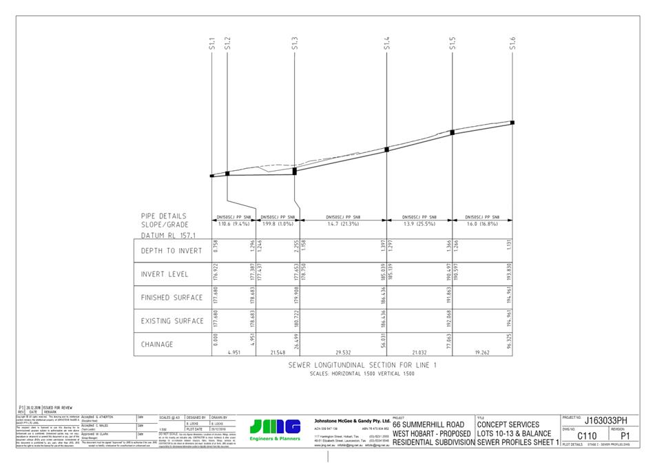
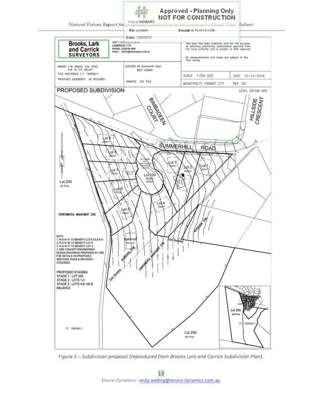
4.5. There is no application for subdivision or development as part of this amendment, although an indicative subdivision and servicing plan has been submitted to demonstrate a possible scenario.
Existing situation
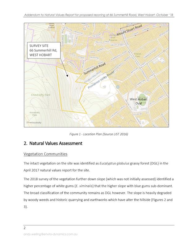
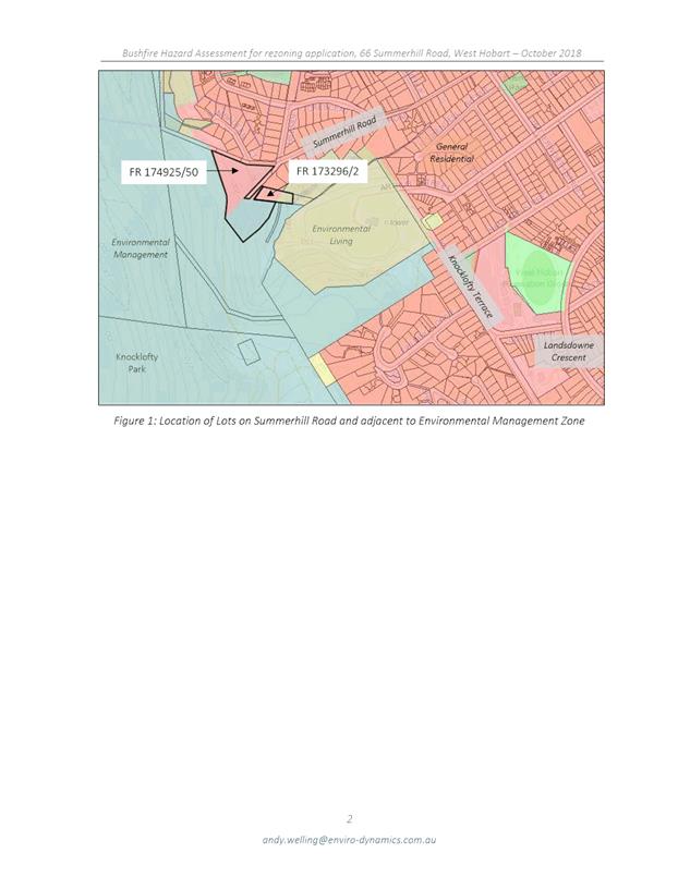
4.6. The site is located on the fringe of existing residential development at the end of Summerhill Road in West Hobart, and adjoins the City-owned Knocklofty Reserve (see Figure 1).
4.7. The land is generally east facing and partly vegetated. The dominant vegetation type is Eucalyptus globulus dry forest and woodland, although it is significantly weed infested.
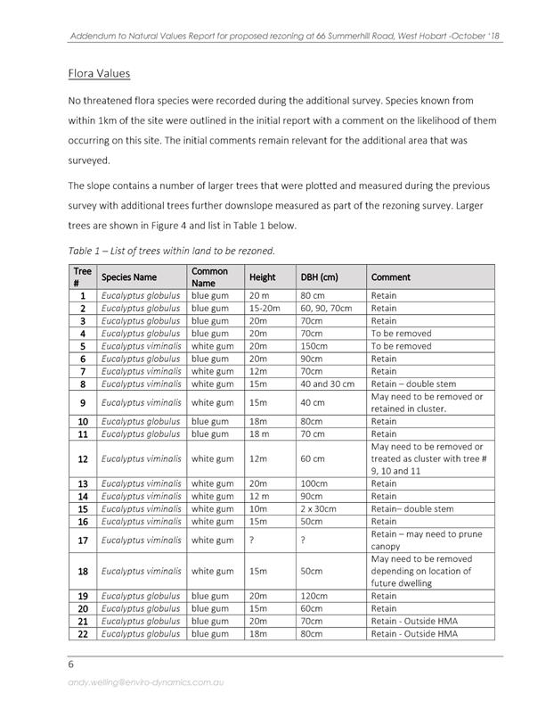
4.8. The site is currently partly zoned General Residential, Environmental Living and Environmental Management.
4.9. It is noted that the zoning maps of the Council’s GIS overlays (see Figure 1) align differently with the underlying property boundaries compared to the State Government’s LISTmap property boundaries (see Figure 2).
4.10. Advice from the Tasmanian Planning Commission (TPC) GIS unit is that this is due to adjustments made to the LISTmap cadastre to align property boundaries more closely with zone boundaries, although there does not appear to have been any formal amendments to the zoning maps to reflect this. It is recommended that the TPC formally resolve this mapping inconsistency.
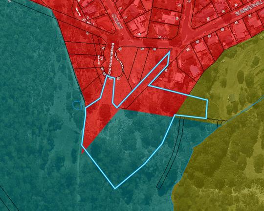
Figure 1: Subject site showing existing zoning (Council GIS)
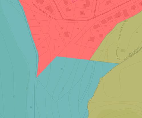
Figure 2: Subject site showing existing zoning (LISTmap)
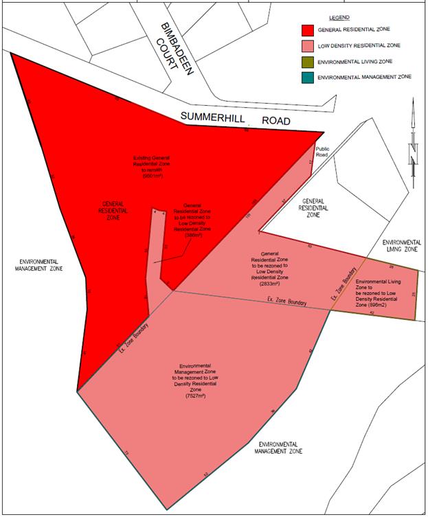
Figure 3: Proposed rezoning of subject site
Planning Scheme Provisions
4.11. The Zone Purpose Statements of the Environmental Management Zone are:
To provide for the protection, conservation and management of areas with significant ecological, scientific, cultural or aesthetic value or with a significant likelihood of risk from a natural hazard.
To only allow for complementary use or development where consistent with any strategies for protection and management.
To facilitate passive recreation opportunities which are consistent with the protection of natural values in bushland and foreshore areas.
To recognise and protect highly significant natural values on private land.
To protect natural values in un-developed areas of the coast.
4.12. Allowable uses under the Environmental Management Zone are generally limited to those that have a public benefit. Permitted uses are generally only those compatible with a reserve management plan. Use and development standards under this zone are primarily focussed towards protecting vegetation and landscape values.
4.13. The Zone Purpose Statements of the Environmental Living Zone are:
To provide for residential use or development in areas where existing natural and landscape values are to be retained. This may include areas not suitable or needed for resource development or agriculture and characterised by native vegetation cover, and where services are limited and residential amenity may be impacted on by nearby or adjacent rural activities.
To ensure development is reflective and responsive to the natural or landscape values of the land.
To provide for the management and protection of natural and landscape values, including skylines and ridgelines.
To protect the privacy and seclusion that residents of this zone enjoy
To provide for limited community, tourism and recreational uses that do not impact on natural values or residential amenity.
To encourage passive recreational opportunities through the inclusion of pedestrian, cycling and horse trail linkages.
4.14. Allowable uses under the Environmental Living Zone are generally focussed towards residential or recreation uses, as well as some discretionary community uses. Use and development standards are primarily focussed towards retaining residential amenity and natural values.
4.15. The Zone Purpose Statements of the General Residential Zone are:
To provide for residential use or development that accommodates a range of dwelling types at suburban densities, where full infrastructure services are available or can be provided.
To provide for compatible non-residential uses that primarily serve the local community
To provide for the efficient utilisation of services.
To encourage residential development that respects the neighbourhood character.
To provide a high standards of residential amenity.
To allow commercial uses which provide services for the needs of residents of a neighbourhood and do not displace an existing residential use or adversely affect their amenity particularly through noise, traffic generation and movement, and the impact of demand for on-street parking.
4.16. Allowable uses under the General Residential Zone are focussed towards residential uses, with some commercial uses (primarily in existing commercial buildings) that serve the local community. Use and development standards are generally focussed towards achieving residential amenity, allowing for suburban level of density.
4.17. The Zone Purpose Statements of the Low Density Residential Zone are:
To provide for residential use or development on larger lots in residential areas where there are infrastructure or environmental constraints that limit development.
To provide for non-residential uses that are compatible with residential amenity.
To encourage residential development that respects the neighbourhood character.
To provide a high standard of residential amenity.
To ensure that development respects the natural and conservation values of the land and is designed to mitigate any visual impacts of development on public views.
4.18. Allowable uses under the Low Density Residential Zone are generally focussed towards residential uses, with a limited number of other community-focussed uses. The only allowable commercial use is Domestic animal breeding, boarding or training, with discretion.
4.19. Use and development standards under the Low Density Residential Zone are generally focussed towards achieving residential amenity, at a lower density level than for general urban areas.
Tasmanian Planning Scheme
4.20. The Environmental Management, General Residential and Low Density Residential zones under the Tasmanian Planning Scheme (TPS) are substantially similar to the equivalent zones under the HIPS 2015. There is no equivalent ‘Environmental Living’ zone.
4.21. Some differences in the Low Density Residential Zone under the TPS compared to the HIPS 2015 include that a slightly wider range of discretionary non-residential uses are allowable. In addition, the site area per dwelling for multiple dwellings is set at the same area as the minimum lot size for serviced lots (1500m2), and there is no maximum permitted lot size. The absolute minimum lot size is 1200m2.
4.22. Under the HIPS 2015, the site area per dwelling requirement under the Low Density Residential Zone is greater than the minimum lot size (1500m2 and 1000m2 respectively), and there is a maximum lot size of 2,500m2. There is no discretion to approve lots either below the minimum or above the maximum permitted lot sizes unless for open space purposes.
5. Proposal and Implementation
5.1. The proposal is to amend the Hobart Interim Planning Scheme 2015 (HIPS 2015) zoning maps by rezoning part of the property at 66 Summerhill Road to Low Density Residential from Environmental Management, Environmental Living and General Residential.
5.2. The proposal is also to submit a request to the Minister of Planning to amend the STRLUS by extending the UGB to include the rezoned area.
Justification – Applicant’s Submission
5.3. The applicant considers that the requested rezoning amendment is justified for the following reasons:
5.3.1. The subject site is capable of being serviced by sewer and water infrastructure.
5.3.2. A natural values report indicates that the conservation value of the vegetation community on the site is significantly diminished due to substantial weed infestation. Many of the large trees on the site can be retained even following subdivision.
5.3.3. It is considered that following the proposed rezoning, three lots and a balance could be provided. This would provide for a transition of density from the General Residential Zone through to Environmental Management and Environmental Living zoned land, reflecting orderly development and reducing bushfire clearance and vegetation maintenance on non-residentially zoned land.
5.3.4. The proposal includes an element of ‘back-zoning’ from General Residential to Low Density Residential, and therefore the change in overall development potential will not be significantly altered.
5.3.5. The proposed rezoning removes split zoning of the site and provides for a more logical and systematic pattern of residential development reflective of site constraints.
5.3.6. The proposed rezoning and development potential will not have an unreasonable impact on visual landscape values. The land is at a similar or lower contour level compared to adjoining land that is already developed, and the vegetated ridgeline will remain.
5.3.7. The site is highly modified already and the area that is suitable for development is substantially cleared of vegetation.
5.3.8. While part of the site is subject to the Landslide Hazard Area Overlay, building envelopes can be accommodated outside of these areas. A submitted landslide risk management report concludes the risk posed on the site is low, instability and erosion from vegetation removal is low and acceptable, and expected development should not have a significant effect on land stability on the site or neighbouring properties.
5.3.9. A submitted Bushfire Hazard Management Plan (BHMP) indicates that hazard management areas based on BAL-19 construction could be contained within the lot boundaries for a four lot subdivision with building envelopes close to the northern lot boundary.
5.3.10. The proposal is consistent with the STRLUS in that:
· Future lot sizes are such that house sites and associated bushfire hazard management areas can be adequately accommodated within the lot boundaries, minimising the impact on broader vegetation values and managing bushfire risk;
· Adequate land area will be provided to enable a future subdivision that incorporates house sites outside of landslide hazard risk areas;
· An area of the original site has been provided to Council to formalise walking tracks and links to Knocklofty Reserve;
· The rezoning presents a logical transition in the pattern of development and the existing potential of the site;
· the proposal does not represent residential growth but rather an alternative layout for residential development that is more sustainable and responsive to site characteristics;
· the application of the Low Density Residential Zone is reflective of the constraints of the site;
5.3.11. The proposal is consistent with the Objectives of the Resource Management and Planning System, in particular that it:
· Promotes sustainable development given it minimises impacts on bushland while allowing for appropriate residential development;
· Provides for the fair, orderly and sustainable use and development of land given it enables a transition of density without further impacting on significant vegetation or landscape values;
· Encourages public involvement through a public exhibition process;
· Facilitates economic development in that it contributes to the provision of housing and maximises use of infrastructure and services;
· Promotes the sharing of responsibility between government, community and industry by way of the rezoning process;
· Represents sound strategic planning as it is a logical and orderly expansion of a residential area at an appropriate density, removing split-zoning of sites;
· Does not affect the established system of planning instruments, allowing future development of the land to be considered against the planning scheme;
· Considers effects on the environment and social and economic impacts as environmental values on the land can be managed appropriately;
· Contributes to a pleasant, efficient and safe working, living and recreational environment in that it allows of a transition of land between established residential areas and Knocklofty Reserve;
· Conserves places of aesthetic interest as it retains the existing contour line beyond which the existing development pattern does not currently extend.
· Does not impact on the coordination of public and other facilities and infrastructure.
5.3.12. The proposal does not contravene the State Policy on Water Quality Management 1997 as the planning scheme provisions will ensure use and development is undertaken in accordance with the policy.
5.3.13. There are unlikely to be any potential land use conflicts as the proposal provides for an orderly graduation of lot sizes and sustainable utilisation of land that is otherwise constrained.
5.3.14. The size and configuration of potential lots means development opportunities will be limited on the site, and therefore the regional impact of the proposal is negligible.
5.4. In relation to the amendment to the STRLUS to extend the UGB, the applicant considers the request is justified for the following reasons:
5.4.1. The STRLUS was declared 9 years ago, and has had little review since.
5.4.2. Maintaining a forward rolling supply of residential land is critical to orderly land release that does not have adverse effects on affordability of housing supply.
5.4.3. The UGB was originally intended to be a ‘management’ tool to control orderly release of new land, not a ‘restrictive’ tool requiring all land to be converted and used for urban purposes before more is released.
5.4.4. The UGB was developed through a relatively inexact process that took into account the best available data on capacity of infrastructure, values, hazards, existing zoning and proposed zoning amendments. There were some constraints associated with this data, and with the dwelling forecast and dwelling yield analysis conducted.
5.4.5. Originally the UGB was not intended to be read at a cadastral level and the map was notated to reflect the indicative nature of the line, which was anticipated to adjust taking into account local investigations into values, hazards and other constraints.
5.4.6. In 2013 the UGB was changed from a ‘fuzzy’ line to a ‘black and white line’, at the behest of some councils in order to provide for easier application. This has caused an unreasonable degree of regulatory burned on proposed small scale land releases around the UGB such as the one proposed for this amendment.
5.4.7. Population increase in greater Hobart since the STRLUS was prepared has been greater than predicted, and 2019 predictions from the Department of Treasury and Finance confirms greater increases into the future than accounted for under the STRLUS.
5.4.8. The rezoning at 66 Summerhill Road would facilitate potentially 3 additional lots suited to single dwellings in a well serviced and located area. This is only 0.01% of the dwelling demand underlying the UGB which is negligible and has no effect on the overall attainment of the residential and settlement policies within the STRLUS.
Justification - Comment
5.5. The applicant has submitted some valid reasons in support of the rezoning.
5.6. As the land has been assessed to not contain vegetation that is of high conservation value, and the potential hazards are manageable, retention of the site within the Environmental Management Zone is not warranted.
5.7. It is not considered that the land reflects the Zone Purpose Statements of the Environmental Management Zone, particularly:
To provide for the protection, conservation and management of areas with significant ecological, scientific, cultural or aesthetic value or with a significant likelihood of risk from a natural hazard.
5.8. The area of the original site that did have conservation and recreation value has now been transferred to City of Hobart ownership.
5.9. It is considered that the Low Density Residential Zone is a reasonable alternative zone for the remainder of the site, including the portion currently zoned General Residential which includes site constraints, such as landslide hazard areas, that will likely limit potential development density.
5.10. The replacement of the small section zoned Environmental Living is appropriate as the vegetation community is compromised and it is unlikely any housing will be developed in this area. The indicative subdivision plan suggests this area will likely remain part of a large balance lot that does not have further subdivision potential. The Low Density Residential Zone with a Biodiversity Protection Area Overlay will still allow consideration of any hazards and values in this section of land if further development were to be proposed.
5.11. The Low Density Residential Zone will recognise existing site constraints and limit high density development in the area. Future development on the site is considered to be capable of meeting the zone purpose statements of the Low Density Residential Zone.
5.12. The zone provides for a transition in density between the General Residential Zone and adjoining Environmental Living and Environmental Management zoned areas.
5.13. In terms of development potential, the difference in the number of lots or developments theoretically possible is not significant.
5.14. Under the current zoning, there is the theoretical capacity for 5-6 permitted dwellings on the site (0 on the Environmental Management zoned land and 5-6 on the General Residential/Environmental Living zoned land).
5.15. If the site were to be rezoned as proposed, under the HIPS 2015, the Low Density Residential Zone could theoretically yield up to 11 lots or 7 multiple dwellings (minimum lot size of 1000m2, minimum land per multiple dwelling of 1500m2). It is noted however that, in terms of subdivision, available frontage to a road is restricted and therefore the maximum number of lots would not be achievable.
5.16. The draft Hobart Local Provisions Schedule (LPS) currently proposes that the areas of this site currently zoned Environmental Living or Environmental Management be zoned Rural Living C. This zone has a minimum permitted lot size of 5 hectares.
5.17. Under the LPS, the multiple split zoning of the site would continue. Removal of the site’s split zoning as proposed by the amendment will be a positive outcome as it consolidates development potential and simplifies assessments.
5.18. Under the draft LPS as currently zoned, the development potential would theoretically allow for approximately 6-7 permitted dwellings (1 on the Rural Living C zoned portion of land, 5-6 on the General Residential zoned portion of land.) If the site were to be rezoned as proposed when the LPS is approved, the development potential would be approximately 7 lots or 7 multiple dwellings.
5.19. The number of lots or dwellings that could be practically realised on the site following rezoning is highly likely to be lower than the maximum theoretical number due to access constraints, servicing constraints, natural hazards and gradient.
5.20. The applicant has provided an indicative subdivision plan that shows three additional lots plus balance. This is considered to be a more realistic potential, assuming servicing for each potential dwelling can be achieved.
5.21. Essentially, the rezoning will result in a larger area of land available for residential purposes, but not a significantly greater number of permitted dwellings or lots, compared to the existing situation.
5.22. Avoiding zoning privately owned land as Environmental Management is consistent with the established strategic direction favoured under the Tasmanian Planning Scheme.
5.23. It is agreed that the development of additional houses in the northern section of the site will not have a significant adverse impact from a visual point of view, given the existing line of development, the recently approved subdivision, the primarily cleared nature of the building areas, and the small number of possible dwellings.
5.24. The proposal was referred to relevant Council officers. Comments are provided below:
Open Space and Recreation
5.24.1. There does not appear to be any clearing for bushfire protection required on Council land outside the indicative new blocks.
5.24.2. Almost all trees could be retained on the new lots, and there would be some reduction in the area covered by gorse. Ongoing gorse control to provide a buffer for the reserve is highly desirable.
5.24.3. Pedestrian access between the existing cul-de-sac and Knocklofty Reserve is desirable in the subsequent subdivision;
5.24.4. The rezoning proposal is supported in principle.
Stormwater
5.24.5. The indicative subdivision plan shows 4 building areas clustered to the north of the site to allow access, servicing, avoid landslide areas and minimise bushfire clearing.
5.24.6. Both the Northern and Southern tributaries of Providence Rivulet have identified capacity issues, as does the public stormwater system in Hillside Crescent. Flow maintenance would be required for future subdivision/development, including for the proposed zone’s acceptable density. This would likely be conditioned on any subdivision permit as a Part 5 agreement.
5.24.7. The submitted concept servicing plan shows only a very small area of the indicative Lots could drain via gravity. Some lots (particularly ‘lot 11’ and the balance lot) of the indicative subdivision would struggle to get through LG(BMP) or the planning scheme provisions relating to services for subdivision (HIPS 2015 Clause 12.5.4) if not submitted simultaneously with house plans as the building area (considered as the ground surface) could not drain by gravity. Onsite disposal would not be supported due to the steepness and landslip risk, and Council does not accept pumped drainage disposal for subdivisions.
5.24.8. There are, however, possible alternative servicing layouts (for example mains below the building area roughly following 186m contour but above the landslide zone, subject to geotechnical advice, rather than confined to access strips). The majority of the rezoned area is not able to be developed - the building areas must be clustered along the northern boundary, as indicated in the concept subdivision layout.
5.24.9. The fire trail to the west of the site has previously concentrated water, causing issues over the site. As part of the Council contract to purchase land, it was proposed to redirect some of these flows to above Bimbadeen Court. The remaining section would sheet flow to Providence Rivulet. If these works have been carried out, the proposed land will be largely unaffected. If it has not, this is still unlikely to be an issue given the likely building areas.
5.24.10. The new outcome for maximum acceptable developed area following the rezoning is difficult to judge, but theoretically stays fairly consistent (1924m2 of existing General Residential land could yield 5 multiple dwellings with 75% impervious surfaces. Approx. 11,000m2 of Low Density Residential land could yield 7 dwellings).
5.24.11. In reality, however, it would be difficult to develop the current General Residential zoned lot to this density given the site constraints. The proposed rezoning will therefore slightly increase the practicable development potential of the land.
5.24.12. In summary, the rezoning is supported, noting:
· Only a small area of the proposed rezoned land is able to be serviced by future public stormwater, and Council would not support the development of the unserviced land. Future subdivision/development would require extensive stormwater design.
· Future subdivision/development would require flow management/detention.
· Whilst development suited to the proposed zone could occur, the indicative subdivision would face some challenges in its current form.
Development Engineering
5.24.13. There are concerns that the recently constructed cul-de-sac head on Summerhill Road is insufficiently sized to allow fire trucks to turn around. As such, a sign was installed as part of that subdivision which prohibits fire trucks to enter the cul-de-sac. Inability for fire trucks to access the Fire Hydrant would mean the Bushfire Hazard Management Plan (BHMP) does not adequately cover fire protection.
5.24.14. Despite these concerns, however, the Tasmania Fire Service (TFS) have provided some advice that indicates they consider access to the cul-de-sac fire hydrant as viable and adequate for appliance manoeuvring. However, the TFS do have concerns regarding all building areas being within 120m unobstructed hose lay of the hydrant, and do not believe the BHMP adequately addresses this issue and proposes an adequate solution. An updated BHMP will need to be provided at subdivision stage to demonstrate an adequate water access solution can be achieved
5.24.15. Notwithstanding the TFS advice relating to access, a suggestion to improve ease of access to the Fire Hydrant is to connect the shared driveway servicing indicative lots 10 and 11. From review of JMG Concept Servicing Plan C100 it appears this may be possible (with alterations to driveway gradients requiring review) with realignment permitting a fire truck to drive through from one shared driveway to the other.
Environmental Planning
5.24.16. A full report by Council’s Environmental Development Planner is provided as Attachment D.
5.24.17. Generally, it is concluded that the site can reasonably accommodate development consistent with the proposed zone (Low Density Residential).
5.24.18. It is noted that some design alterations may need to be made to the indicative subdivision plan to meet bushfire hazard management requirements. A Bushfire Hazard Management Plan prepared for a subsequent subdivision will need to resolve the issue of adequate hose-lay distance to each building site to ensure compliance with the Bushfire Prone Areas Code.
5.24.19. It is recommended that as part of the rezoning the Biodiversity Protection Area should be extended to cover all areas of the site that were previously not covered by this overlay. This will help to protect a particular very large white gum which may represent the most significant value on the lot from a conservation perspective for its age, size and habitat potential (including hollows). Protection of this tree and other existing vegetation that is outside of the current extent of the Biodiversity Protection Area is considered to go a considerable way in offsetting the impact of any future development of the land.
5.25. In relation to the request to amend the UGB under the STRLUS, it is considered that this is a reasonable request given the minor nature of the extension, and the suitability of the site to be used for low density residential purposes.
5.26. An information sheet (RLUS 1) was issued by the Planning Policy Unit (Department of Justice) to provide guidance on amending regional land use strategies.
5.27. Under the RLUS 1, amendments to strategies must include justification on how the change being sought:
(a) Furthers the Schedule 1 objectives of LUPAA;
(b) Is in accordance with State Policies made under section 11 of the State Policies and Project Act 1993;
(c) Is consistent with the Tasmanian Planning Policies, once they are made; and
(d) Meets the overarching strategic directions and related policies in the regional land use strategy.
5.28. Further justification is required for those amendments that relate to the development of greenfield sites, including impacts on natural values, risks from hazards, impacts on road networks, impacts on adjoining land use and consideration of agricultural values.
5.29. It is considered that each of the above issues have been adequately covered in this report in relation to the proposed rezoning.
5.30. The RLUS 1 strongly recommends that proposed amendments are accompanied by an endorsement from other planning authorities in the relevant region, and that State Service agencies, State authorities and infrastructure providers are consulted. However, given the minor nature of this proposal and the unlikely event of any impact on other planning authorities, this is considered unnecessary at this stage. TasWater will be notified during the exhibition process if the amendment is initiated, as per usual process.
5.31. The RLUS 1 specifically requests the following information where a modification to the Urban Growth Boundary is sought:
(a) Justification for any additional land being required beyond that already provided for under the existing regional land use strategy. This analysis should include the current population growth projections prepared by the Department of Treasury and Finance;
(b) Analysis and justification of the potential dwelling yield for the proposed additional area of land;
(c) Analysis of land consumption (i.e. land taken up for development) since the regional land use strategy was declared;
(d) Justification for any additional land being located in the proposed area, considering the suitability of the area in terms of access to existing physical infrastructure, public transport, and activity centres that provide social services, retail and employment opportunities;
(e) Consideration of appropriate sequencing of land release within the local area and region;
(f) Consideration of any targets for infill development required by the regional land use strategy;
(g) Potential for land use conflicts with use and development on adjacent land that might arise from the proposed amendment.
5.32. The applicant has submitted a response to these requirements (see attachment C). The position of the applicant generally is that the minor nature of the extension and the low potentially dwelling yield means detailed analysis against many of the RLUS 1 requirements are unnecessary.
5.33. It is considered that this is a reasonable position, and the Planning Policy Unit under the Department of Justice has confirmed that in this instance the documentation provided is sufficient to advance the request to amend the STRLUS.
5.34. The proposal to amend the Urban Growth Boundary under the STRLUS is supported.
6. Strategic Planning and Policy Considerations
6.1. The proposed amendment is consistent with the objectives of the Capital City Strategic Plan 2019-29, in particular with the following outcomes:
6.1.1. Hobart keeps a strong sense of place and identity, even as the city changes;
6.1.2. Hobart’s cityscape reflects the heritage, culture and natural environment that make it special;
6.1.3. In City decision-making, we consider how different aspects of Hobart life connect and contribute to sense of place;
6.1.4. The natural environment is part of the city and biodiversity is preserved, secure and flourishing;
6.1.5. Development enhances Hobart’s unique identity, human scale and built heritage;
6.1.6. Community involvement and an understanding of future needs help guide changes to Hobart’s built environment.
7. Financial Implications
7.1. Funding Source and Impact on Current Year Operating Result
7.1.1. None.
7.2. Impact on Future Years’ Financial Result
7.2.1. None.
7.3. Asset Related Implications
7.3.1. None.
8. Legal, Risk and Legislative Considerations
8.1. The Land Use Planning and Approvals Act 1993 (LUPAA) requires that planning scheme amendments must seek to further the Objectives of Schedule 1 of the Act and be prepared in accordance with the State Policies.
8.2. The Objectives of LUPAA require use and development to occur in a fair, orderly and sustainable manner and for the planning process to facilitate economic development in accordance with the other Schedule 1 Objectives.
8.3. It is considered that the proposed amendment meets the Objectives of LUPAA, in particular it:
8.3.1. Does not unreasonably compromise natural resources or ecological processes and encourages serviced land with easy access to public infrastructure to be effectively utilised;
8.3.2. Is a fair, orderly and sustainable use of the site as it does not adversely impact on environmental values, and provides for economic development through increased housing provision in close proximity to the city;
8.3.3. Assists sound strategic planning by not prejudicing the achievement of the relevant zone objectives or the STRLUS objectives;
8.3.4. Is consistent with the objective to establish a system of planning instruments to be the principal was of setting objectives, policies and controls for the use, development and protection of land;
8.3.5. Provides greater flexibility to address changes in local, environmental, social and economic circumstances;
8.3.6. Allows for more efficient use of existing infrastructure and facilities;
8.3.7. Considers the provision of a pleasant, efficient and safe environment for residents and visitors to Hobart;
8.3.8. Considers the capability of the zone and allowable uses that are likely to have minimal land use conflict with surrounding uses.
8.4. The only State Policy relevant to the proposed rezoning is the State Policy on Water Quality Management 1997. As the HIPS 2015 includes provisions that ensure use and development is undertaken in accordance with the policy, it is considered that the rezoning and future development on the site will not contravene this policy.
8.5. S32(e) of the former provisions of LUPAA requires that planning scheme amendments must, as far as practicable, avoid the potential for land use conflicts with use and development permissible under the planning scheme applying to the adjacent area. This amendment is considered to be appropriate in the context of adjoining land use. It provides for a transition in residential density, and the area of the site that is capable of containing dwellings is concentrated close to the existing General Residential Zone boundary. The site is not adjacent to any areas controlled by a different planning scheme.
8.6. S32(f) of the former provisions of LUPAA requires that planning scheme amendments must have regard to the impact that use and development permissible under the amendment will have on the use and development of the region as an entity in environmental, economic and social terms. The proposed amendment is relatively minor in nature, and will not have any significant impact on use or development at a regional level. The proposal is not considered to impact negatively on environmental values of the site, given the extent and condition of vegetation on the site. Supporting use of appropriate city fringe land for housing supports economic development, housing choice, and accessibility to transport and services for future residents.
8.7. S30O of LUPAA requires that an amendment to an interim planning scheme is as far as practicable consistent with the regional land use strategy. It is considered that this amendment is consistent with the Southern Tasmania Regional Land Use Strategy 2010-2035 (STRLUS), in particular that it:
8.7.1. Manages significant native vegetation at the earliest possible stage of the land use planning process by considering the conservation value of the site, and extending the Biodiversity Protection Area Overlay to include some currently unprotected vegetation (particularly a very old and large white gum with hollows) – in accordance with policy BNV 1;
8.7.2. Adequately manages the risk from natural hazards from bushfire and land instability, in accordance with policies MRH 1 and MRH 3;
8.7.3. Maximises the efficiency of existing physical infrastructure, in accordance with policy PI 1;
8.7.4. Gives preference to urban expansion in close physical proximity to existing transport corridors and higher order Activity Centres, in accordance with policy LUTI 1;
8.7.5. Provides a sustainable and compact pattern of residential development, only utilising the Low Density Residential Zone where it is necessary to manage land constraints in accordance with policy SRD 1 and SRD 2.
8.8. It is noted that consistency with the UGB of the STRLUS is dependent on the Minister’s determination of the concurrent application to amend the STRLUS.
9. Environmental Considerations
9.1. The proposed amendment has been considered in terms of its impact on the environmental values of the site. The documentation submitted indicates the proposed rezoning will not have an unreasonable environmental impact, and this has been supported by Council’s Environmental Development Planner.
10. Social and Customer Considerations
10.1. The proposal is not considered to have any negative impact on social inclusion.
11. Marketing and Media
11.1. There are no marketing or branding implications of this amendment.
12. Community and Stakeholder Engagement
12.1. The Council has requested that reports which recommend the initiation of planning scheme amendments address the need to conduct a public meeting or forum to explain the proposed amendments and also outline the explanatory information to be made available. These are addressed below:
12.1.1. It is not considered that a public forum is necessary to explain the proposed amendment to the public as it is relatively simple and self-explanatory.
12.1.2. The following information will be made available on the website: a copy of this report, a copy of the formal amendment document and the applicant’s submission.
13. Delegation
13.1. Delegation rests with the Council.
As signatory to this report, I certify that, pursuant to Section 55(1) of the Local Government Act 1993, I hold no interest, as referred to in Section 49 of the Local Government Act 1993, in matters contained in this report.
|
Sarah Crawford Development Planner |
Neil Noye Director City Planning |
Date: 13 October 2020
File Reference: F20/97691; PSA-18-2
Attachment a: Rezoning
Plan ⇩ ![]()
Attachment
b: Rezoning
Supporting Documentation ⇩ ![]()
Attachment
c: STRLUS
Amendment Justification ⇩ ![]()
Attachment
d: Environmental
Development Planner Assessment ⇩ ![]()
Attachment
e: Instrument
of Certification ⇩ ![]()
|
Item No. 8.1 |
Agenda (Open Portion) City Planning Committee Meeting - 19/10/2020 |
Page 264 ATTACHMENT a |
|
Item No. 8.1 |
Agenda (Open Portion) City Planning Committee Meeting - 19/10/2020 |
Page 301 ATTACHMENT b |

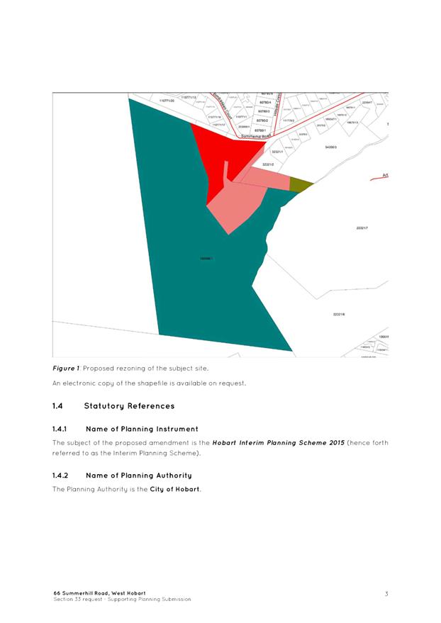

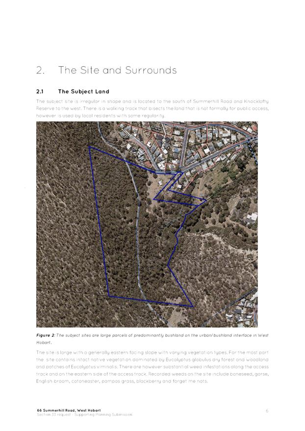
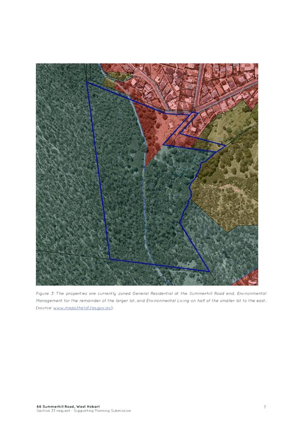
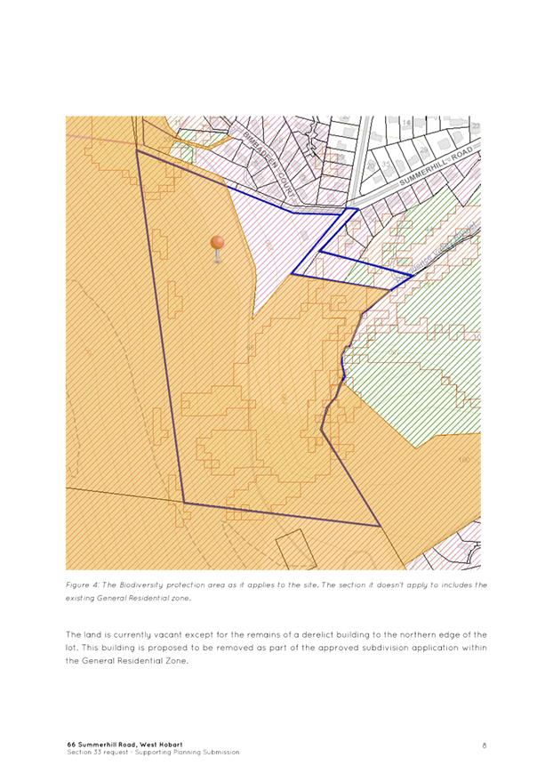
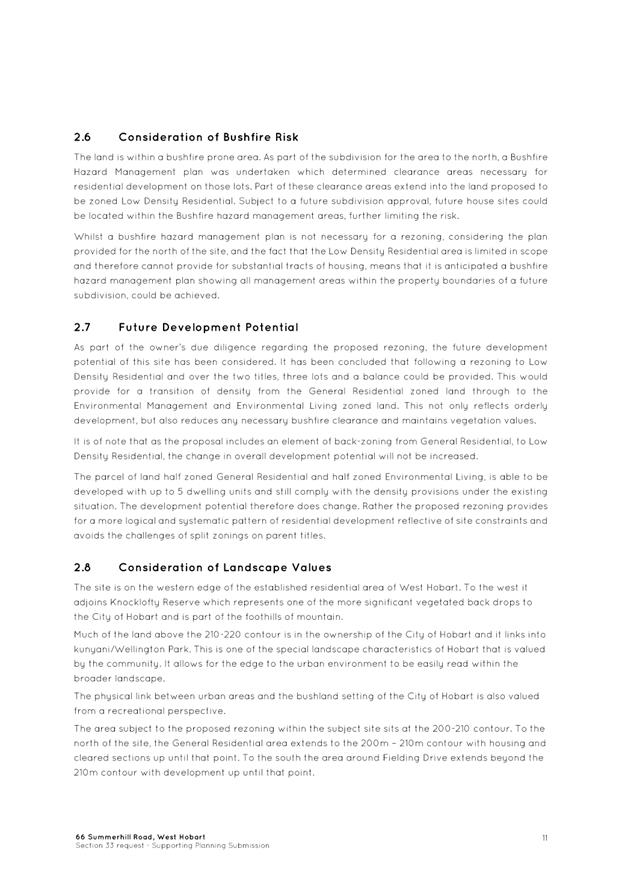
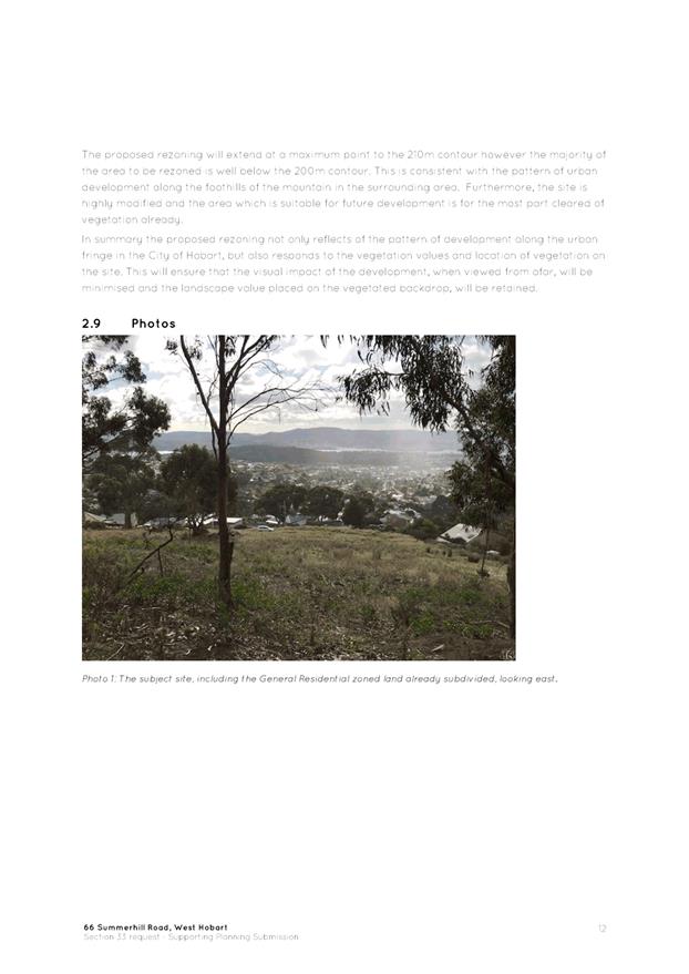
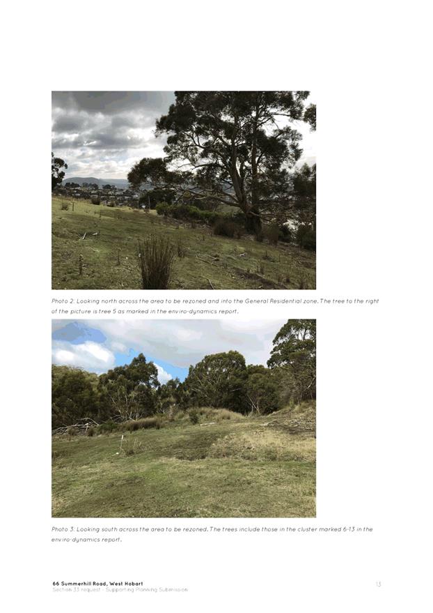
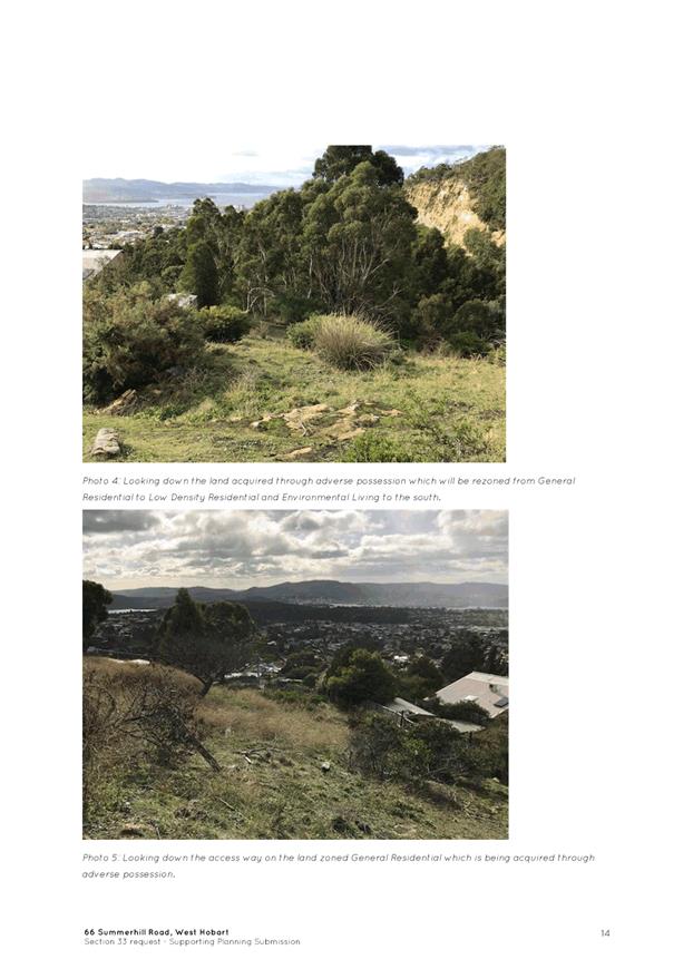
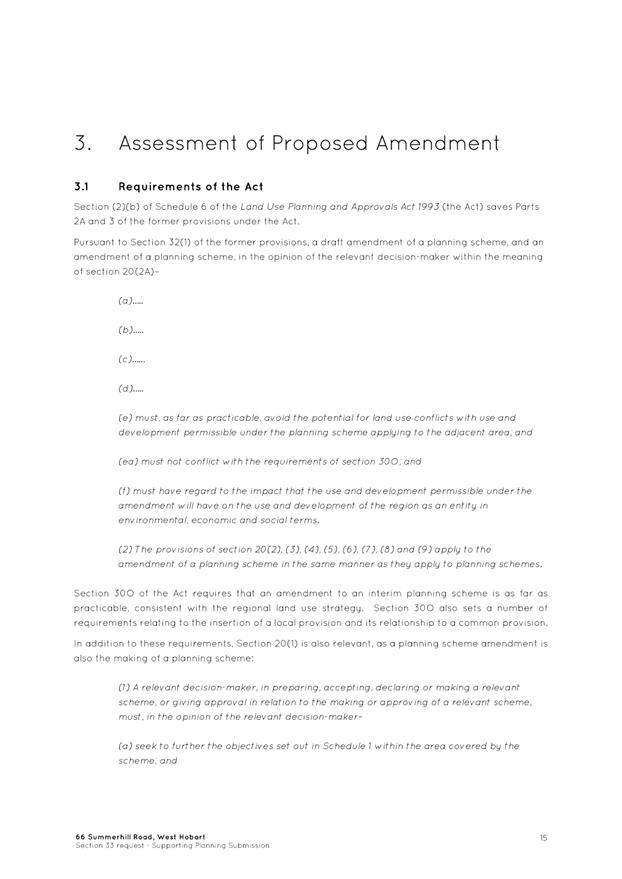
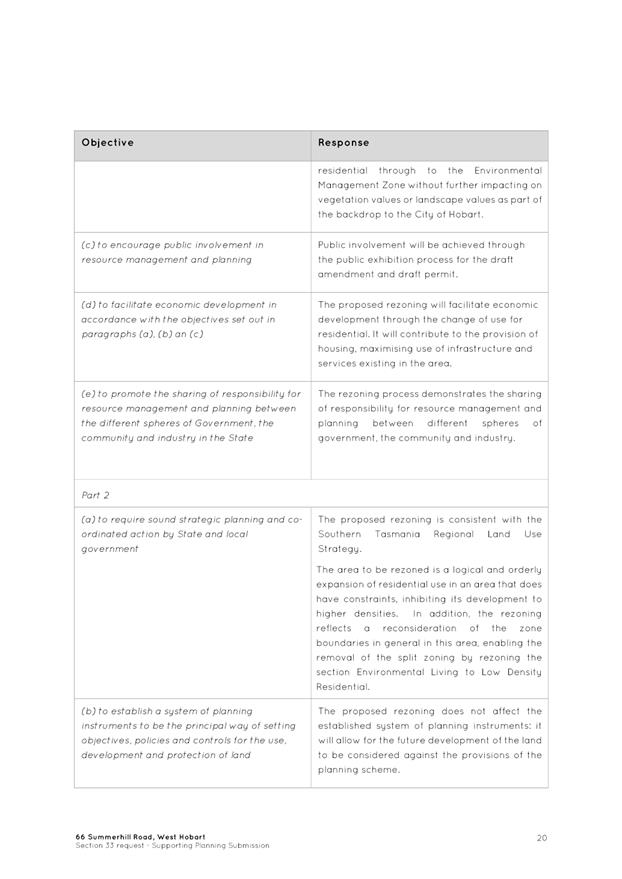
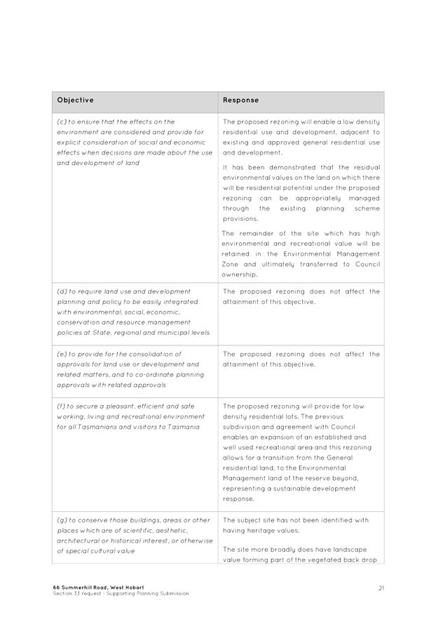
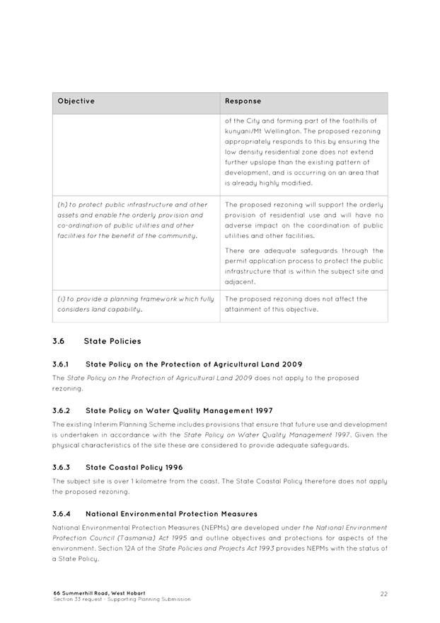
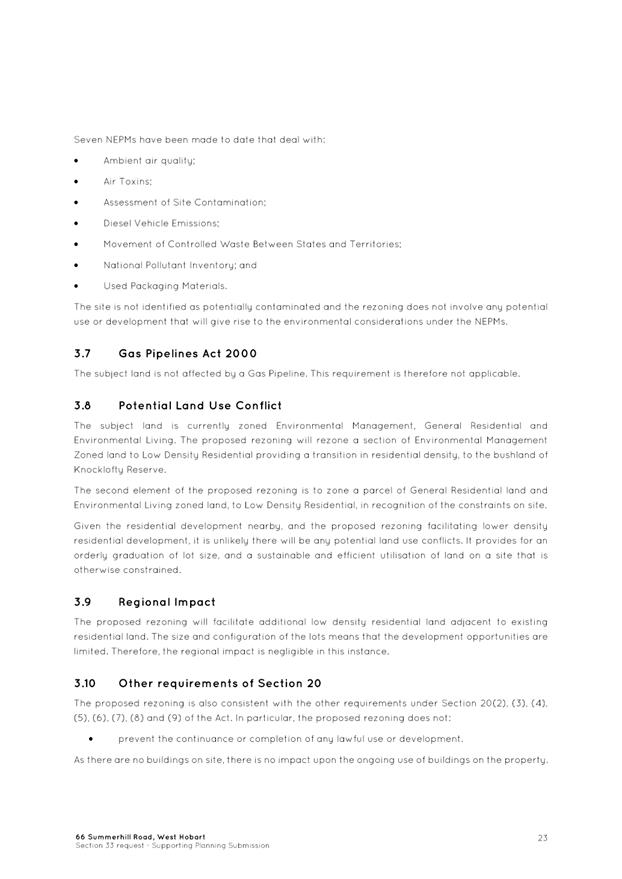

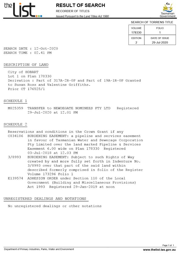
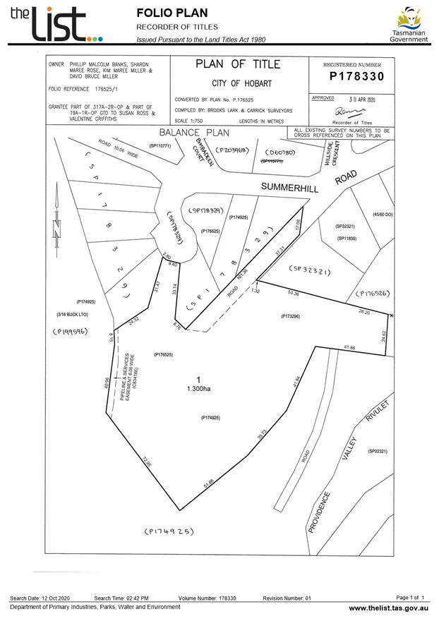
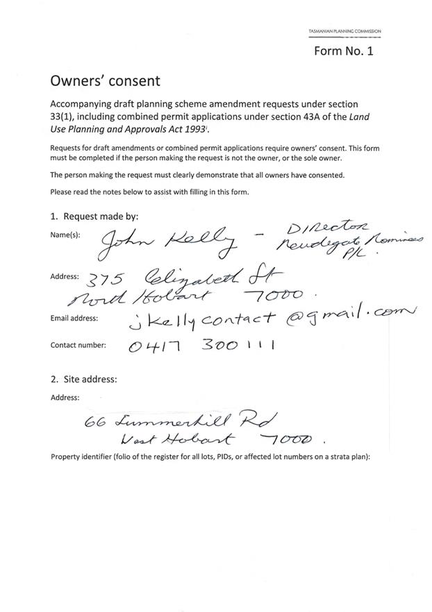
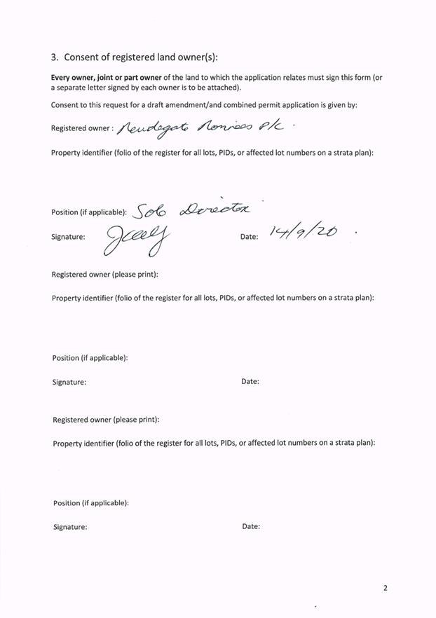

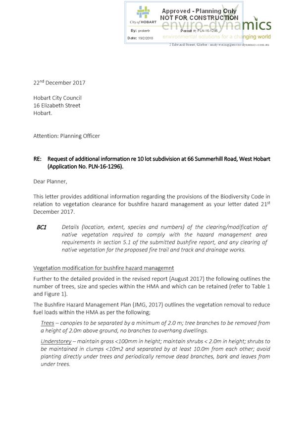
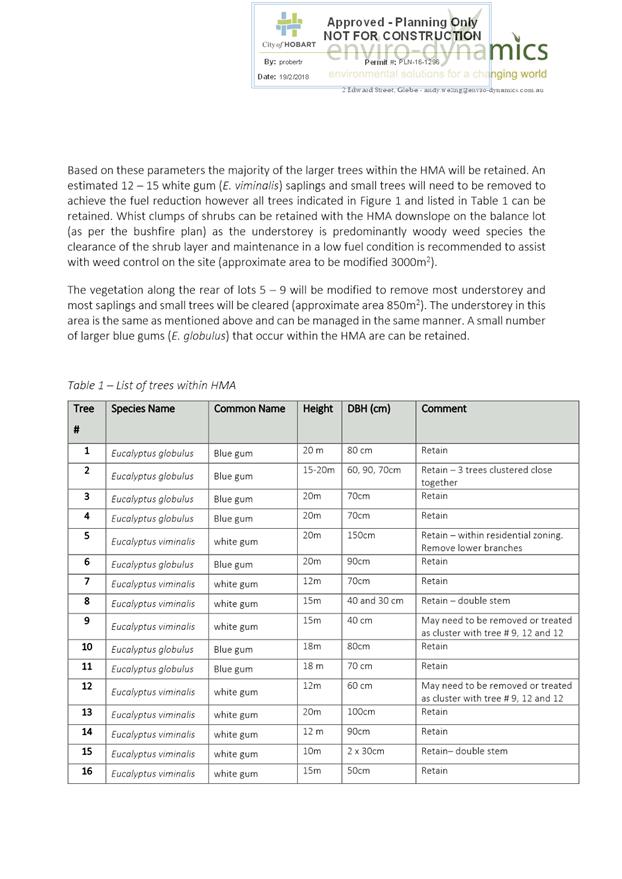
|
Agenda (Open Portion) City Planning Committee Meeting - 19/10/2020 |
Page 363 ATTACHMENT c |
|
Agenda (Open Portion) City Planning Committee Meeting - 19/10/2020 |
Page 378 ATTACHMENT d |
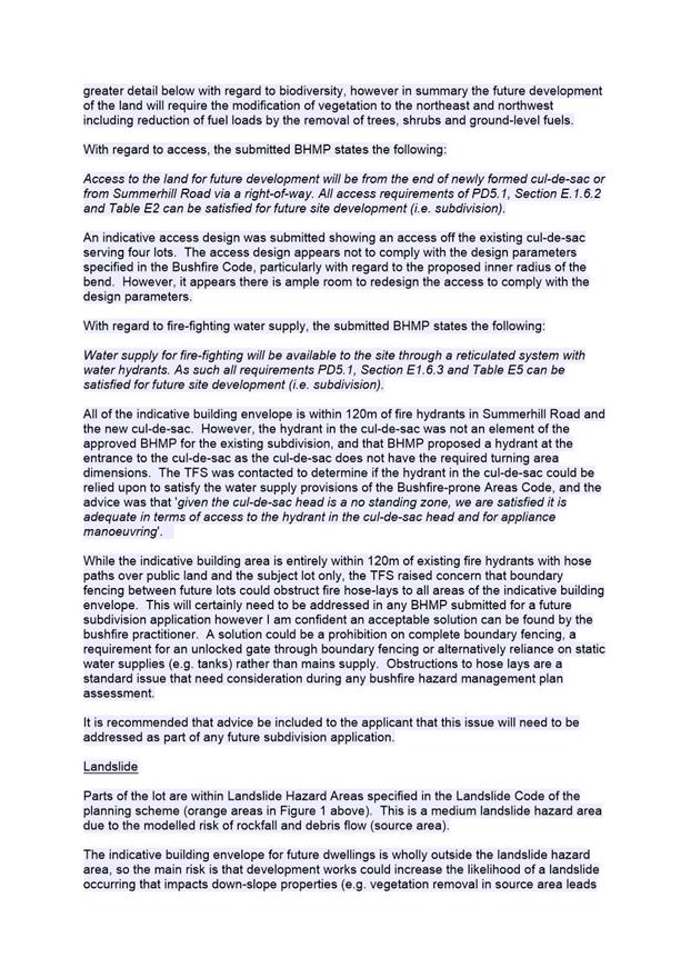
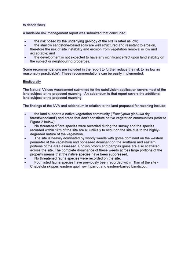
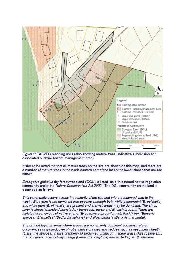
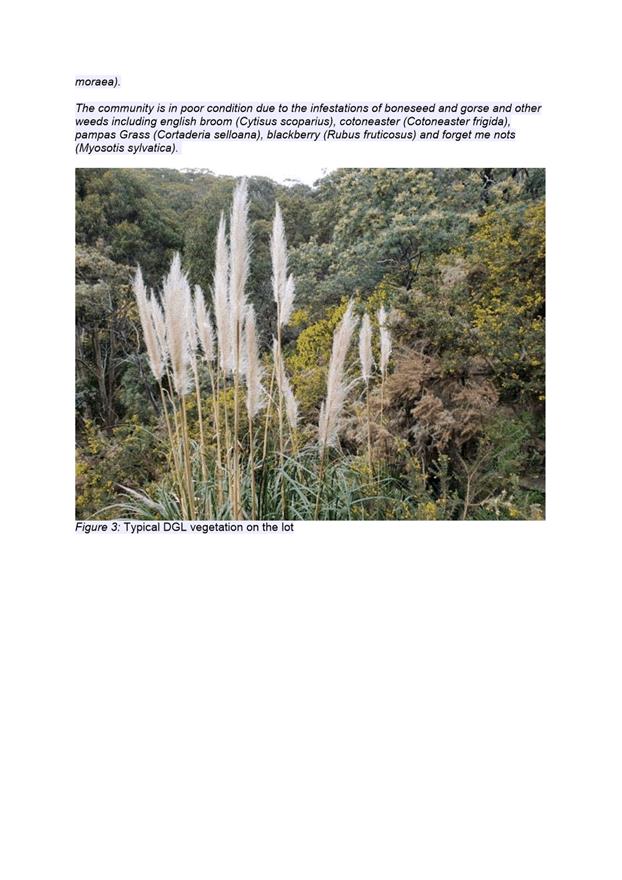
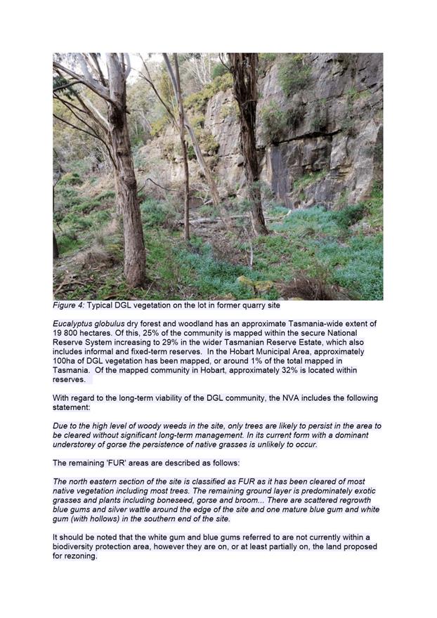
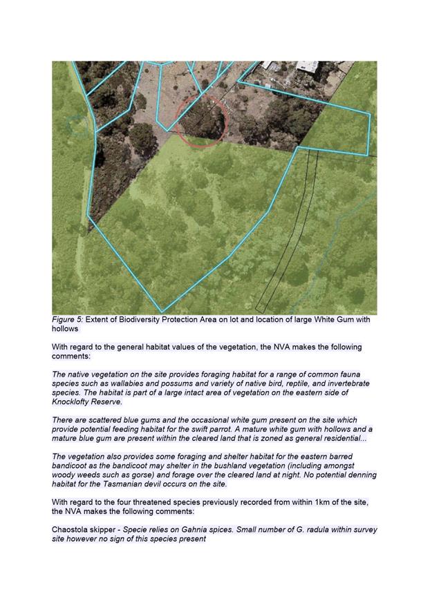
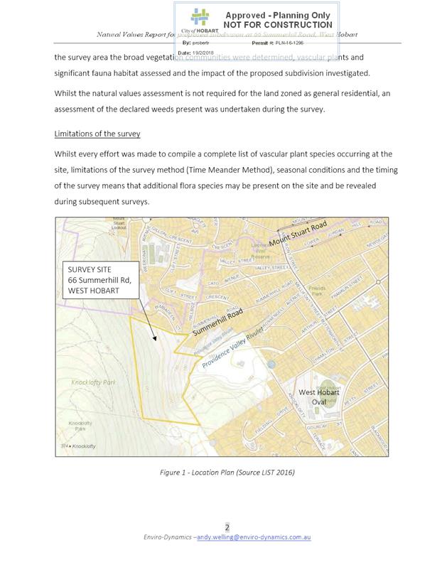
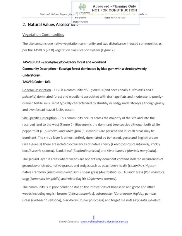
|
Agenda (Open Portion) City Planning Committee Meeting - 19/10/2020 |
Page 396 ATTACHMENT e |
|
Item No. 8.2 |
Agenda (Open Portion) City Planning Committee Meeting |
Page 397 |
|
|
19/10/2020 |
|
8.2 Delegated Decisions Report (Planning)
Memorandum of the Director City Planning of 14 October 2020 and attachment.
Delegation: Committee
|
Item No. 8.2 |
Agenda (Open Portion) City Planning Committee Meeting |
Page 398 |
|
|
19/10/2020 |
|

Memorandum: City Planning Committee
Delegated Decisions Report (Planning)
Attached is the delegated planning decisions report for the period 21 September 2020 to 9 October 2020.
|
That: 1. That the information be received and noted.
|
As signatory to this report, I certify that, pursuant to Section 55(1) of the Local Government Act 1993, I hold no interest, as referred to in Section 49 of the Local Government Act 1993, in matters contained in this report.
|
Neil Noye Director City Planning |
|
Date: 14 October 2020
File Reference: F20/109245
Attachment a: Delegated
Decisions Report (Planning) ⇩ ![]()
|
Item No. 8.2 |
Agenda (Open Portion) City Planning Committee Meeting - 19/10/2020 |
Page 400 ATTACHMENT a |
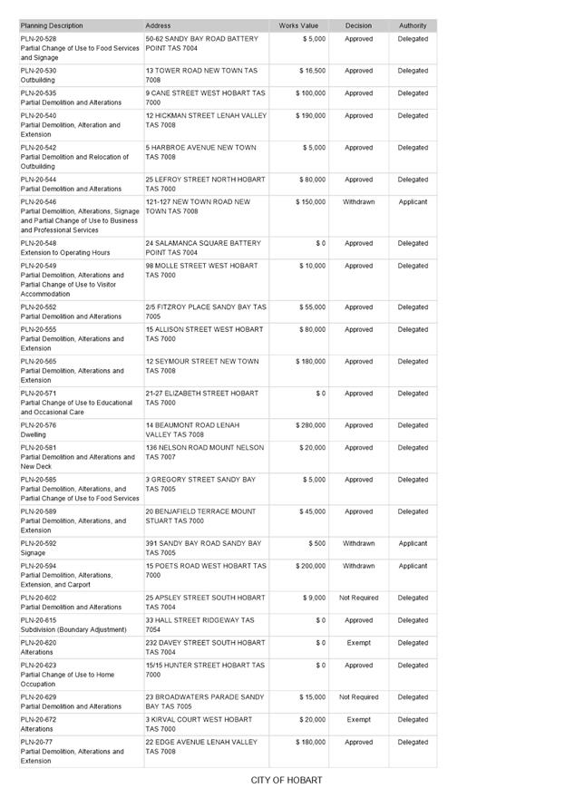
|
Agenda (Open Portion) City Planning Committee Meeting |
Page 401 |
|
|
|
19/10/2020 |
|
8.3 City Planning - Advertising Report
Memorandum of the Director City Planning of 14 October 2020 and attachment.
Delegation: Committee
|
Item No. 8.3 |
Agenda (Open Portion) City Planning Committee Meeting |
Page 402 |
|
|
19/10/2020 |
|
Memorandum: City Planning Committee
City Planning - Advertising Report
Attached is the advertising list for the period 21 September 2020 to 9 October 2020.
|
That: 1. That the information be received and noted.
|
As signatory to this report, I certify that, pursuant to Section 55(1) of the Local Government Act 1993, I hold no interest, as referred to in Section 49 of the Local Government Act 1993, in matters contained in this report.
|
Neil Noye Director City Planning |
|
Date: 14 October 2020
File Reference: F20/109574
Attachment a: City
Planning - Advertising Report ⇩ ![]()
|
Item No. 8.3 |
Agenda (Open Portion) City Planning Committee Meeting - 19/10/2020 |
Page 406 ATTACHMENT a |
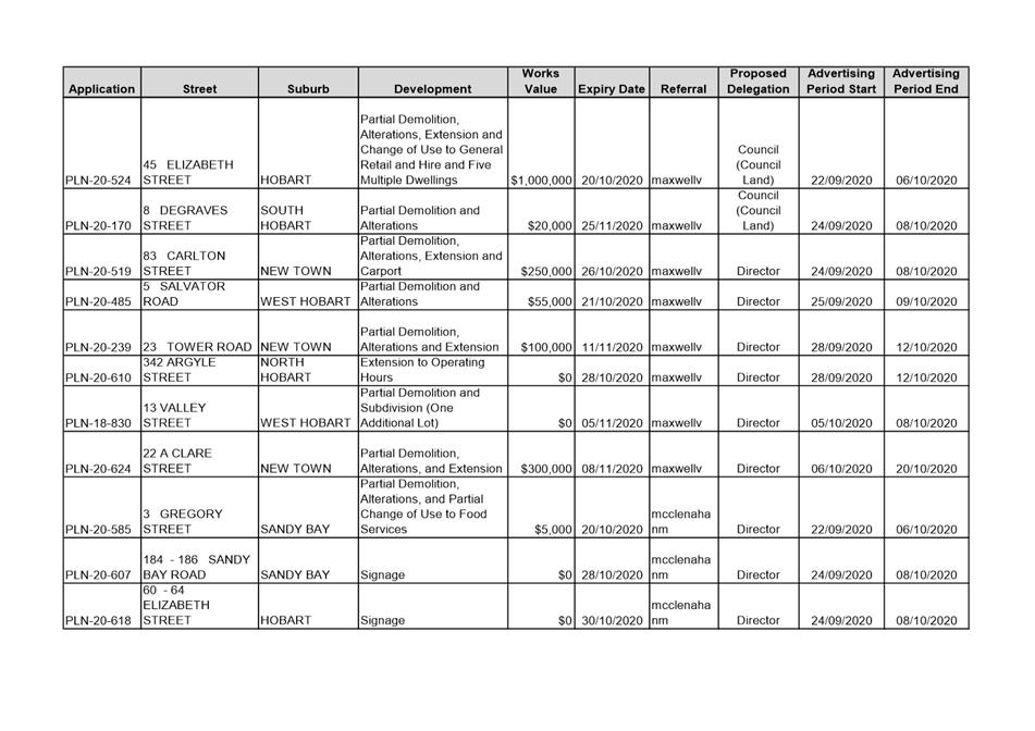
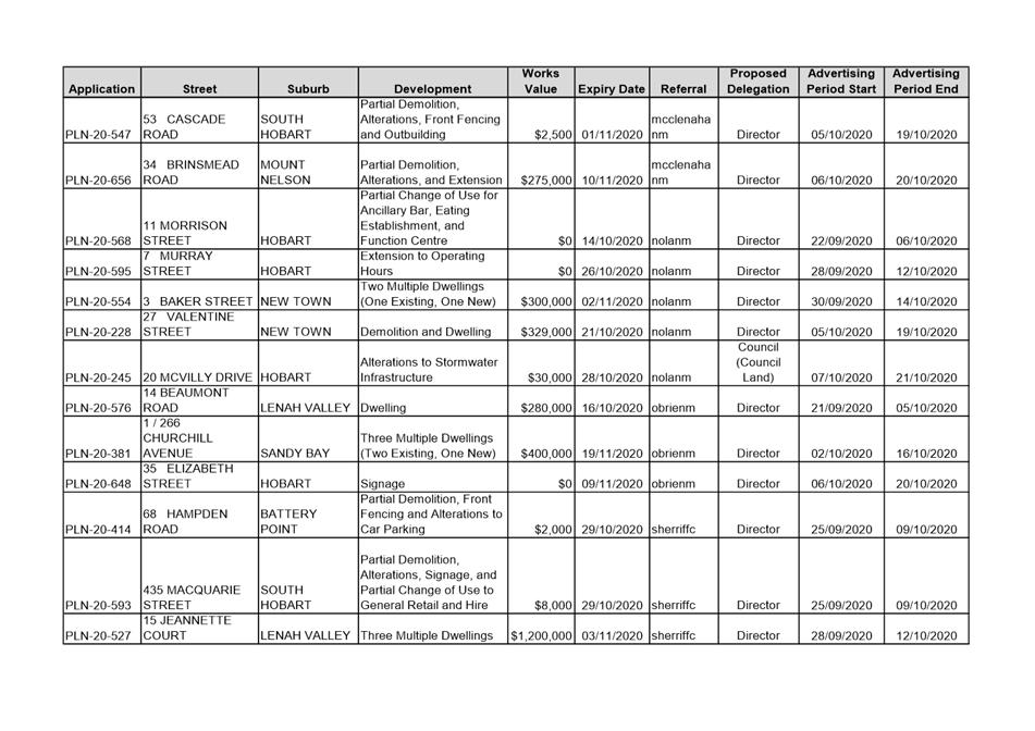
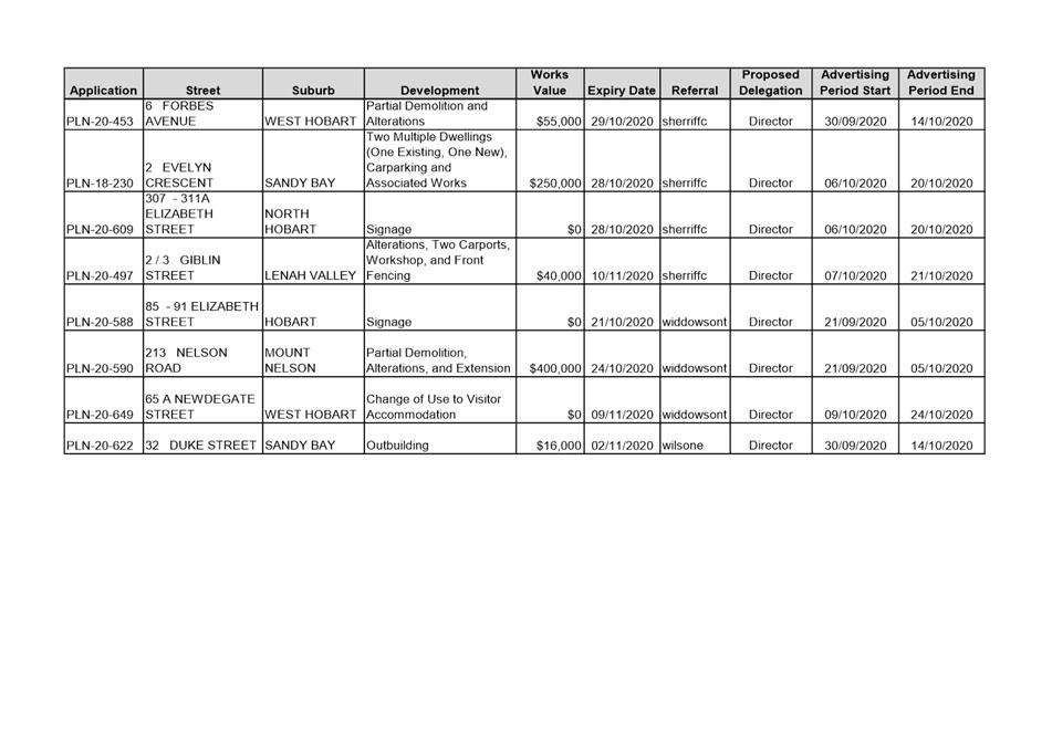
|
Agenda (Open Portion) City Planning Committee Meeting |
Page 407 |
|
|
|
19/10/2020 |
|
8.4 Monthly Building and Planning Statistics - 1 September - 30 September 2020
Memorandum of the Director City Planning of 14 October 2020 and attachments.
Delegation: Committee
|
Item No. 8.4 |
Agenda (Open Portion) City Planning Committee Meeting |
Page 409 |
|
|
19/10/2020 |
|
Memorandum: City Planning Committee
Monthly Building and Planning Statistics - 1 September - 30 September 2020
Attached is the monthly building and planning permit issue statistics for the period 1 September – 30 September 2020.
|
That:
During the period 1 September 2020 to 30 September 2020, 69 building permits were issued to the value of $18,767,569 which included:
(i) 29 for extensions/alterations to dwellings to the value of $4,482,300;
(ii) 22 new dwellings to the value of $3,778,393; and
(iii) 2 major projects:
(a) 48 Liverpool Street, Hobart - Commercial Internal Alterations - $4,100,000; (b) 4-12 Elizabeth Street, Hobart - Commercial Internal Alterations - $2,000,000
2. During the period 1 September 2019 to 30 September 2019, 42 building permits were issued to the value of $13,543,595 which included:
(i) 22 for extensions/alterations to dwellings to the value of $4,453,986;
(ii) 4 new dwellings to the value of $773,209; and
(iii) 2 major projects:
(a) 93 Elizabeth Street, Hobart - Alterations and Change of Use - $1,500,000; (b) 160-162 Elizabeth Street, Hobart - New Building and Alterations - $6,600,000
In the twelve months ending 30 September 2020, 628 permits were issued to the value of $224,352,929; and
In the twelve months ending 30 September 20199, 635 permits were issued to the value of $318,201,388.
|
As signatory to this report, I certify that, pursuant to Section 55(1) of the Local Government Act 1993, I hold no interest, as referred to in Section 49 of the Local Government Act 1993, in matters contained in this report.
|
Neil Noye Director City Planning |
|
Date: 14 October 2020
File Reference: F20/109807
Attachment a: Number
of Building Permits Issued - 5 Year Comparison - September 2020 ⇩ ![]()
Attachment
b: Value
of Building Permits Issued - 5 Year Comparison - September 2020 ⇩ ![]()
Attachment
c: Number
of Planning Permits Issued (Accumulative Monthly Totals) - September 2020 ⇩ ![]()
Attachment
d: Value
of Planning Approvals (Accumulative Monthly Totals)- September 2020 ⇩ ![]()
|
Item No. 8.4 |
Agenda (Open Portion) City Planning Committee Meeting - 19/10/2020 |
Page 410 ATTACHMENT a |
|
Item No. 8.4 |
Agenda (Open Portion) City Planning Committee Meeting - 19/10/2020 |
Page 411 ATTACHMENT b |
|
Item No. 8.4 |
Agenda (Open Portion) City Planning Committee Meeting - 19/10/2020 |
Page 412 ATTACHMENT c |
|
Item No. 8.4 |
Agenda (Open Portion) City Planning Committee Meeting - 19/10/2020 |
Page 413 ATTACHMENT d |
|
Agenda (Open Portion) City Planning Committee Meeting |
Page 414 |
|
|
|
19/10/2020 |
|
Regulation 29(3) Local Government
(Meeting Procedures) Regulations 2015.
File Ref: 13-1-10
The General Manager reports:-
“In accordance with the procedures approved in respect to Questions Without Notice, the following responses to questions taken on notice are provided to the Committee for information.
The Committee is reminded that in accordance with Regulation 29(3) of the Local Government (Meeting Procedures) Regulations 2015, the Chairman is not to allow discussion or debate on either the question or the response.”
9.1 Planning Decisions - Residential Dwellings
File Ref: F20/30674; 13-1-10
Memorandum of the Director City Planning of 14 October 2020.
9.2 Section 56 Land Use Planning Approvals Act 1993 - Minor Amendments
File Ref: F20/100950; 13-1-10
Memorandum of the Director City Planning of 14 October 2020.
9.3 Building Heights - Planning Recommendations
File Ref: F20/100971; 13-1-10
Memorandum of the Director City Planning of 13 October 2020.
9.4 Building Permits - Policy
File Ref: F20/109745
Memorandum of the Director City Planning of 14 October 2020.
Delegation: Committee
|
That the information be received and noted.
|
|
Item No. 9.1 |
Agenda (Open Portion) City Planning Committee Meeting |
Page 416 |
|
|
19/10/2020 |
|
Memorandum: Lord Mayor
Deputy Lord Mayor
Elected Members
Response to Question Without Notice
Planning Decisions - Residential Dwellings
|
Meeting: City Planning Committee
|
Meeting date: 2 March 2020
|
|
Raised by: Alderman Behrakis |
|
Question:
Of the 5% Council delegated and 95% officer delegated decisions for residential dwellings how many have come to the Council and how many have been dealt with by the officers in the past 18 months?
Response:
In the period from 01/09/2018 to 31/03/2020 there were a total of 50 applications for residential dwellings delegated to the Council. 44 applications were approved, these applications amounted to 347 new dwellings.
In the same period there were 136 approved officer delegated applications, these applications amounted to 167 new dwellings.
As signatory to this report, I certify that, pursuant to Section 55(1) of the Local Government Act 1993, I hold no interest, as referred to in Section 49 of the Local Government Act 1993, in matters contained in this report.
|
Neil Noye Director City Planning |
|
Date: 14 October 2020
File Reference: F20/30674; 13-1-10
|
Item No. 9.2 |
Agenda (Open Portion) City Planning Committee Meeting |
Page 417 |
|
|
28/9/2020 |
|
Memorandum: Lord Mayor
Deputy Lord Mayor
Elected Members
Response to Question Without Notice
Section 56 Land Use Planning Approvals Act 1993 - Minor Amendments
|
Meeting: City Planning Committee
|
Meeting date: 14 September 2020
|
|
Raised by: Deputy Lord Mayor Burnet |
|
Question:
Can the Director advise how many applications under Section 56 of the Land Use Planning and Approvals Act 1993 for minor amendments have occurred in decisions made by the Council in the past 12 months?
Response:
In the past 12 months there have been 31 approvals under Section 56 of the Land Use Planning Approval Act 1993 for a minor amendment which the original planning permit was issued by Council delegation.
As signatory to this report, I certify that, pursuant to Section 55(1) of the Local Government Act 1993, I hold no interest, as referred to in Section 49 of the Local Government Act 1993, in matters contained in this report.
|
Neil Noye Director City Planning |
|
Date: 14 October 2020
File Reference: F20/100950; 13-1-10
|
Item No. 9.3 |
Agenda (Open Portion) City Planning Committee Meeting |
Page 419 |
|
|
28/9/2020 |
|
Memorandum: Lord Mayor
Deputy Lord Mayor
Elected Members
Response to Question Without Notice
Building Heights - Planning Recommendations
|
Meeting: City Planning Committee
|
Meeting date: 14 September 2020
|
|
Raised by: Deputy Lord Mayor Burnet |
|
Question:
The decision of the Council on Monday 7 September 2020 for approval of 5-7 Sandy Bay Rd was made in part according to a discretion relating to height. The applicant’s information was referenced in the report to Committee Item 7.1.1 of City Planning Committee meeting 31 August 2020, which referred to the height of a building of 19 metres at 9 Sandy Bay Rd. As yet, whilst the most recent application for 9 Sandy Bay Rd was approved, it has not been built. Could the Director advise as to how many times in the past 3 years has the height of an unconstructed building has been considered relevant in a planning recommendation?
Response:
Reference to unconstructed buildings are made from time to time more by way of background. They are also presented from time to time within the Council’s K2VI digital model of the city and a recent example of that was the approved proposal at 125 Bathurst Street when the proposal for multiple dwellings at 90 Melville Street was being considered.
In the case of the proposal for 5-7 Sandy Bay Road determined at the City Planning Committee meeting of 31st August 2020 it is noted that the officer’s assessment of the proposal was careful to recognise the current height of the building at 9 Sandy Bay Road as two to three storey. Notwithstanding the applicants submission the assessment was correctly determined against the current building form on adjacent sites including 9 Sandy Bay Road not what had been approved by the Council and not yet constructed.
As signatory to this report, I certify that, pursuant to Section 55(1) of the Local Government Act 1993, I hold no interest, as referred to in Section 49 of the Local Government Act 1993, in matters contained in this report.
|
Neil Noye Director City Planning |
|
Date: 13 October 2020
File Reference: F20/100971; 13-1-10
|
Item No. 9.4 |
Agenda (Open Portion) City Planning Committee Meeting |
Page 421 |
|
|
19/10/2020 |
|
Memorandum: Lord Mayor
Deputy Lord Mayor
Elected Members
Response to Question Without Notice
Building Permits - Policy
|
Meeting: City Planning Committee
|
Meeting date: 28 September 2020
|
|
Raised by: Alderman Briscoe |
|
Question:
Can the Director advise if there is any internal policy or efficiency measure to limit the amount of time it takes to receive a building permit?
Response:
Numerous business system improvement measures have been introduced over several years to reduce building approval timeframes including paperless applications and internal referral systems. A new business system is currently being introduced to manage all development applications and we are taking the opportunity to identify and implement additional efficiencies were ever possible. However the timeframe for the determination of an application for a building permit is governed by the Building Act 2016.
The Director’s Specified List specifies a timeframe of 7 days for a permit to refuse or grant a building permit. However, the Permit Authority, when granting a building permit has to be satisfied as the following matters:
(a) the suitability of the premises where proposed permit building work is to be performed;
(b) whether the premises are in, or are, a hazardous area, including the stability of the site;
(c) whether, in the opinion of the permit authority, all appropriate protection work has been performed in respect of the work;
(d) the means of access to the premises, during and after the work, and the provision of water and sanitation to those premises;
(e) any relevant requirements of this Act or of a permit, consent or authority in force under any other Act in respect of those premises;
(f) any other matter that the Director of Building Control determines to be relevant to an application under this Subdivision;
(g) any other matter that the permit authority considers relevant.
If the Permit Authority cannot be satisfied as to the above matters it is bound to refuse the application.
While officers undertake the assessment as quickly as possible with available resources consideration of the above matters cannot always be completed in 7 days. In a large number of applications, the information submitted is deficient and does not allow the Permit Authority to complete its assessment. Rather than refuse an application where the documentation submitted is not sufficient as to be satisfied as to these matters, the Permit Authority requests further information until it is satisfied the building works will comply. While this may lead to delays in granting the permit, it is considered a better outcome for an applicant rather than the application being refused for lack of sufficiency of information.
If an applicant is not satisfied with the timeframe for a decision by the Permit Authority, the Building Act 2016 provides a right of appeal to the Resource Management and Planning Appeal Tribunal against the refusal, or failure, to grant an application for the permit in accordance with the Act. We have had no such appeal against the failure to determine a building application in the last 10 years.
As signatory to this report, I certify that, pursuant to Section 55(1) of the Local Government Act 1993, I hold no interest, as referred to in Section 49 of the Local Government Act 1993, in matters contained in this report.
|
Neil Noye Director City Planning |
|
Date: 14 October 2020
File Reference: F20/109745
|
|
Agenda (Open Portion) City Planning Committee Meeting |
Page 422 |
|
|
19/10/2020 |
|
Section 29 of the Local Government (Meeting Procedures) Regulations 2015.
File Ref: 13-1-10
An Elected Member may ask a question without notice of the Chairman, another Elected Member, the General Manager or the General Manager’s representative, in line with the following procedures:
1. The Chairman will refuse to accept a question without notice if it does not relate to the Terms of Reference of the Council committee at which it is asked.
2. In putting a question without notice, an Elected Member must not:
(i) offer an argument or opinion; or
(ii) draw any inferences or make any imputations – except so far as may be necessary to explain the question.
3. The Chairman must not permit any debate of a question without notice or its answer.
4. The Chairman, Elected Members, General Manager or General Manager’s representative who is asked a question may decline to answer the question, if in the opinion of the respondent it is considered inappropriate due to its being unclear, insulting or improper.
5. The Chairman may require a question to be put in writing.
6. Where a question without notice is asked and answered at a meeting, both the question and the response will be recorded in the minutes of that meeting.
7. Where a response is not able to be provided at the meeting, the question will be taken on notice and
(i) the minutes of the meeting at which the question is asked will record the question and the fact that it has been taken on notice.
(ii) a written response will be provided to all Elected Members, at the appropriate time.
(iii) upon the answer to the question being circulated to Elected Members, both the question and the answer will be listed on the agenda for the next available ordinary meeting of the committee at which it was asked, where it will be listed for noting purposes only.
|
|
Agenda (Open Portion) City Planning Committee Meeting |
Page 423 |
|
|
19/10/2020 |
|