City
of hobart
AGENDA
City Planning Committee Meeting
Open Portion
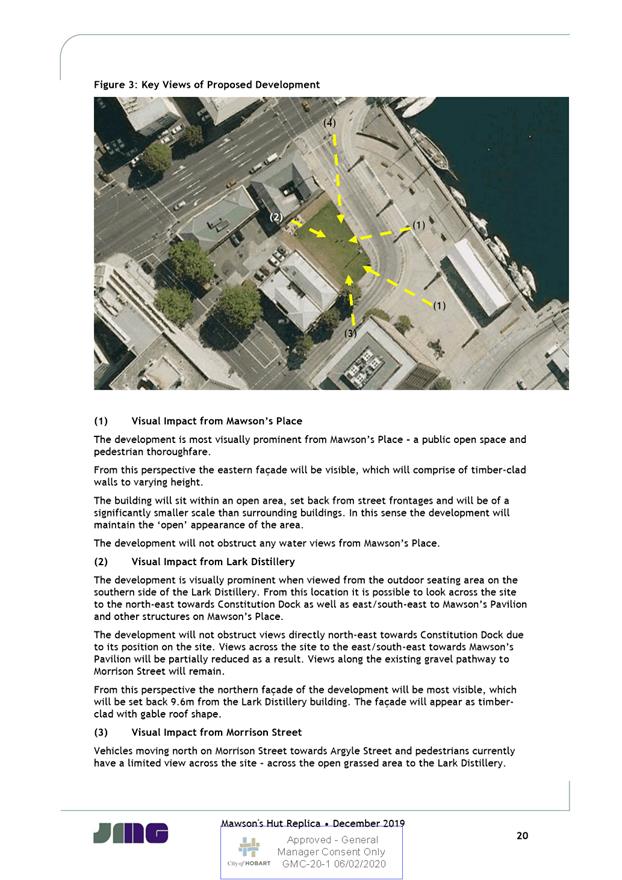
Monday, 16 March 2020
at 5:00 pm
Lady Osborne Room, Town Hall
City
of hobart
AGENDA
City Planning Committee Meeting
Open Portion
Monday, 16 March 2020
at 5:00 pm
Lady Osborne Room, Town Hall
Working together to make Hobart a better place for the community.
THE VALUES
The Council is:
|
People |
We value people – our community, our customers and colleagues. |
|
Teamwork |
We collaborate both within the organisation and with external stakeholders drawing on skills and expertise for the benefit of our community. |
|
Focus and Direction |
We have clear goals and plans to achieve sustainable social, environmental and economic outcomes for the Hobart community. |
|
Creativity and Innovation |
We embrace new approaches and continuously improve to achieve better outcomes for our community. |
|
Accountability |
We work to high ethical and professional standards and are accountable for delivering outcomes for our community. |
|
|
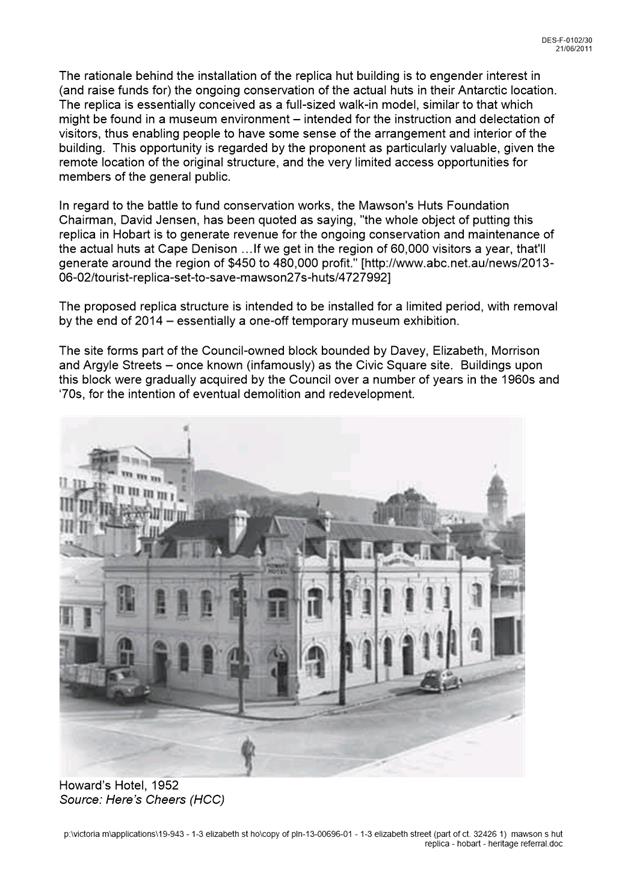
Agenda (Open Portion) City Planning Committee Meeting |
Page 3 |
|
|
16/3/2020 |
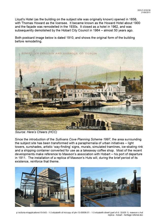
|
Business listed on the agenda is to be conducted in the order in which it is set out, unless the committee by simple majority determines otherwise.
APOLOGIES AND LEAVE OF ABSENCE
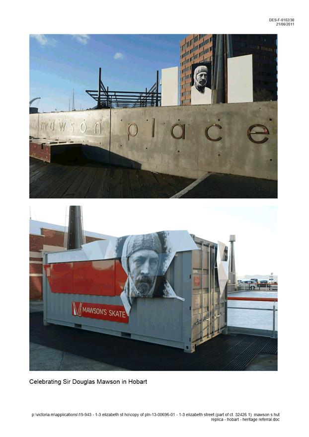
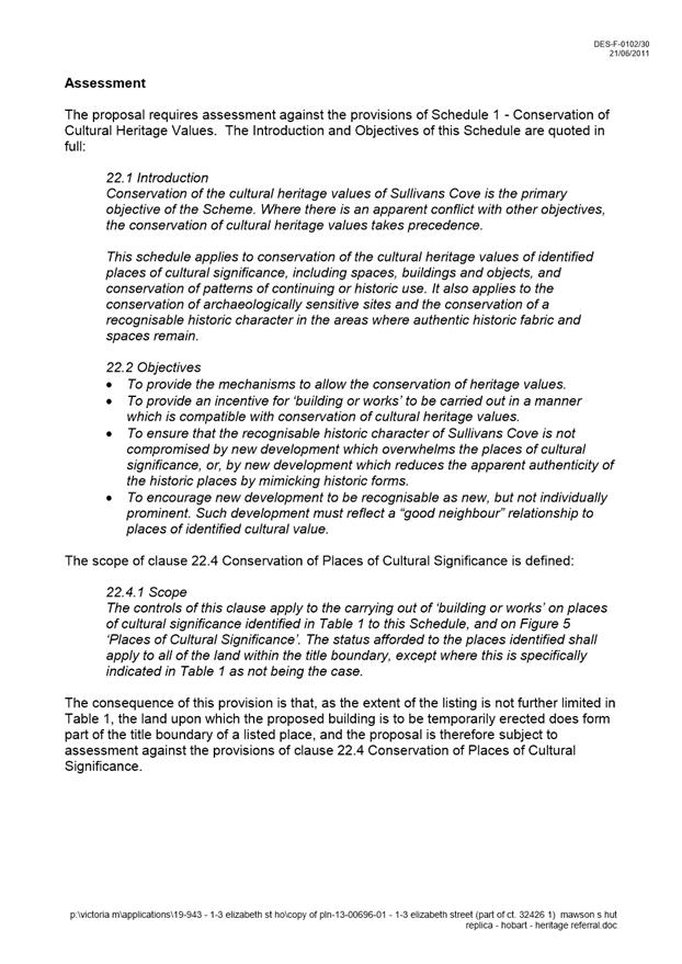
1. Co-Option of a Committee Member in the event of a vacancy
3. Consideration of Supplementary Items
4. Indications of Pecuniary and Conflicts of Interest
6. Planning Authority Items - Consideration of Items With Deputations
7. Committee Acting as Planning Authority
7.1 Applications under the Sullivans Cove Planning Scheme 1997
7.1.1 1-3 Elizabeth Street, Hobart - Partial Change of Use (Mawson's Hut Replica Museum)
7.2 Applications under the Hobart Interim Planning Scheme 2015
7.2.1 1 Glebe Street, Glebe - Sign
7.2.2 PLN-19-818 4 Danval Place, West Hobart
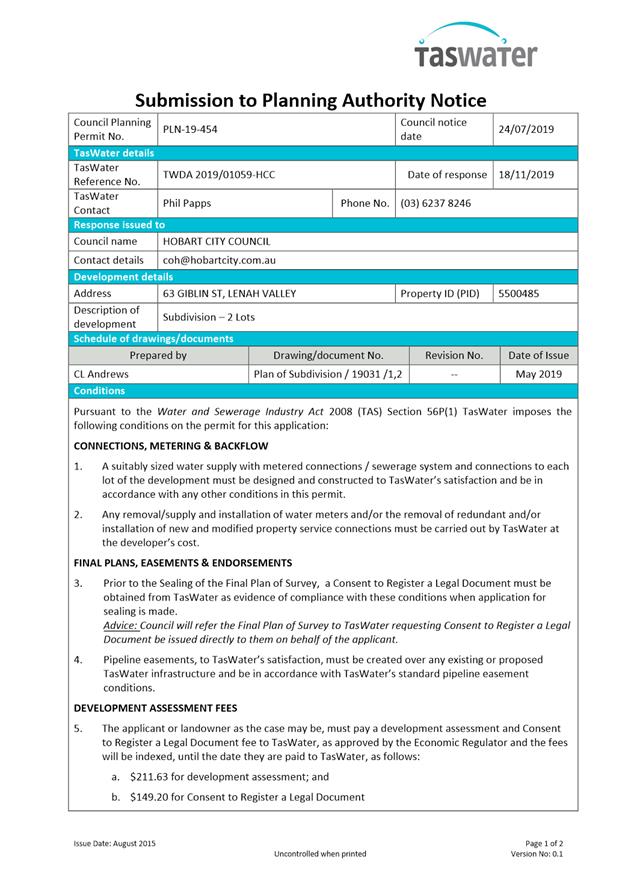
7.2.3 63 Giblin Street, Lenah Valley - Subdivision (One Additional Lot)
7.2.4 67 Woodcutters Road, Tolmans Hill - Partial Demolition, Extension and Alterations
7.2.5 342 Sandy Bay Road, Sandy Bay 1/ 344-346 Sandy Bay Road, Sandy Bay Adjacent Crown Land
8.2 Projected Population and Economic Growth Model
8.3 City Planning - Advertising Report
8.4 Delegated Decisions Report (Planning)
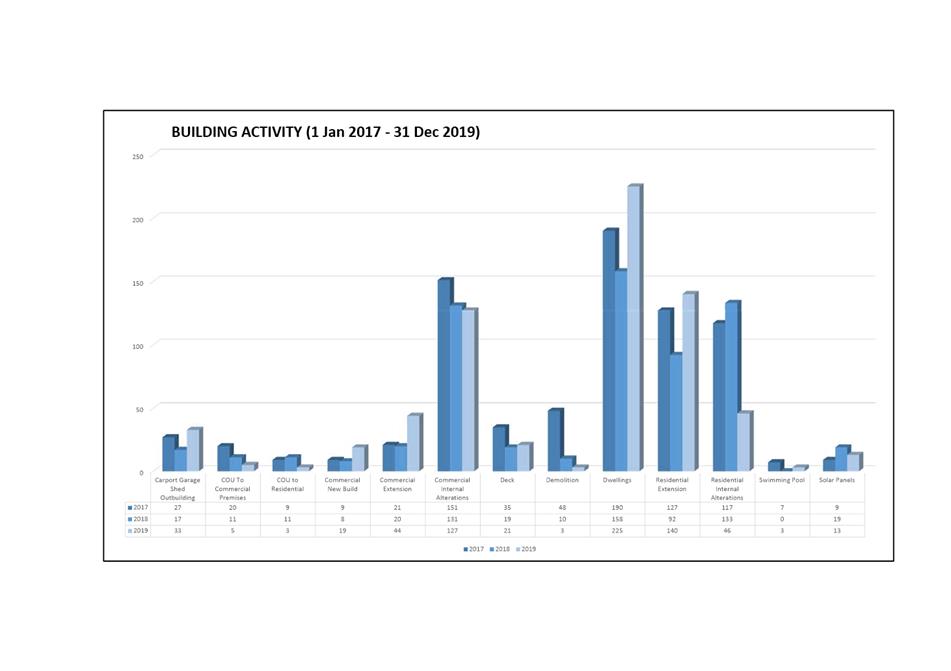
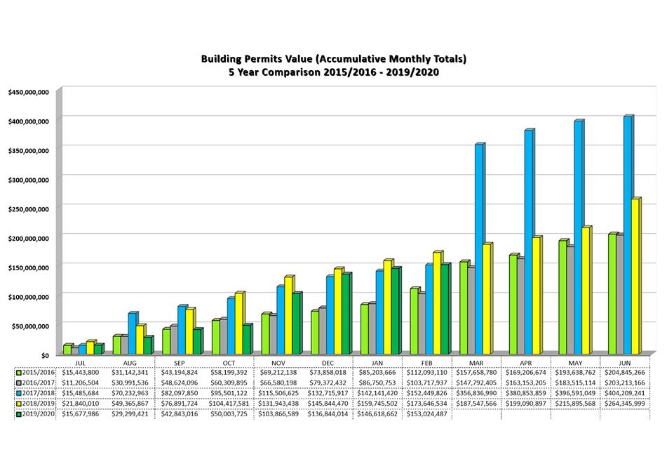
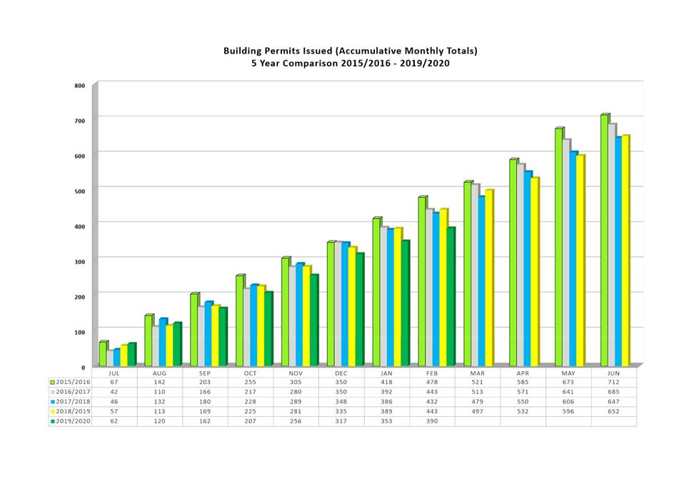
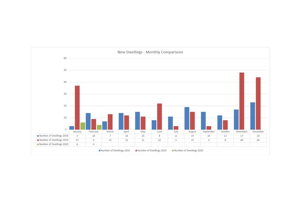
8.5 Monthly Building Statistics - 1 February - 29 February 2020
10. Closed Portion Of The Meeting
|
|
Agenda (Open Portion) City Planning Committee Meeting |
Page 6 |
|
|
16/3/2020 |
|
City Planning Committee Meeting (Open Portion) held Monday, 16 March 2020 at 5:00 pm in the Lady Osborne Room, Town Hall.
|
COMMITTEE MEMBERS Deputy Lord Mayor Burnet (Chairman) Briscoe Harvey Behrakis Dutta Coats
NON-MEMBERS Lord Mayor Reynolds Zucco Sexton Thomas Ewin Sherlock |
Apologies:
Leave of Absence: Councillor M Dutta
|
|
The minutes of the Open Portion of the City Planning Committee meeting held on Monday, 2 March 2020 and the Special City Planning Committee meeting held on Tuesday, 10 March 2020, are submitted for confirming as an accurate record.
|
Ref: Part 2, Regulation 8(6) of the Local Government (Meeting Procedures) Regulations 2015.
|
That the Committee resolve to deal with any supplementary items not appearing on the agenda, as reported by the General Manager.
|
Ref: Part 2, Regulation 8(7) of the Local Government (Meeting Procedures) Regulations 2015.
Members of the committee are requested to indicate where they may have any pecuniary or conflict of interest in respect to any matter appearing on the agenda, or any supplementary item to the agenda, which the committee has resolved to deal with.
Regulation 15 of the Local Government (Meeting Procedures) Regulations 2015.
A committee may close a part of a meeting to the public where a matter to be discussed falls within 15(2) of the above regulations.
In the event that the committee transfer an item to the closed portion, the reasons for doing so should be stated.
Are there any items which should be transferred from this agenda to the closed portion of the agenda, or from the closed to the open portion of the agenda?
In accordance with the requirements of Part 2 Regulation 8(3) of the Local Government (Meeting Procedures) Regulations 2015, the General Manager is to arrange the agenda so that the planning authority items are sequential.
In accordance with Part 2 Regulation 8(4) of the Local Government (Meeting Procedures) Regulations 2015, the Committee by simple majority may change the order of any of the items listed on the agenda, but in the case of planning items they must still be considered sequentially – in other words they still have to be dealt with as a single group on the agenda.
Where deputations are to be received in respect to planning items, past practice has been to move consideration of these items to the beginning of the meeting.
RECOMMENDATION
That in accordance with Regulation 8(4) of the Local Government (Meeting Procedures) Regulations 2015, the Committee resolve to deal with any items which have deputations by members of the public regarding any planning matter listed on the agenda, to be taken out of sequence in order to deal with deputations at the beginning of the meeting.
|
|
Agenda (Open Portion) City Planning Committee Meeting |
Page 7 |
|
|
16/3/2020 |
|
In accordance with the provisions of Part 2 Regulation 25 of the Local Government (Meeting Procedures) Regulations 2015, the intention of the Committee to act as a planning authority pursuant to the Land Use Planning and Approvals Act 1993 is to be noted.
In accordance with Regulation 25, the Committee will act as a planning authority in respect to those matters appearing under this heading on the agenda, inclusive of any supplementary items.
The Committee is reminded that in order to comply with Regulation 25(2), the General Manager is to ensure that the reasons for a decision by a Council or Council Committee acting as a planning authority are recorded in the minutes.
|
Agenda (Open Portion) City Planning Committee Meeting |
Page 11 |
|
|
|
16/3/2020 |
|
7.1 Applications under the Sullivans Cove Planning Scheme 1997
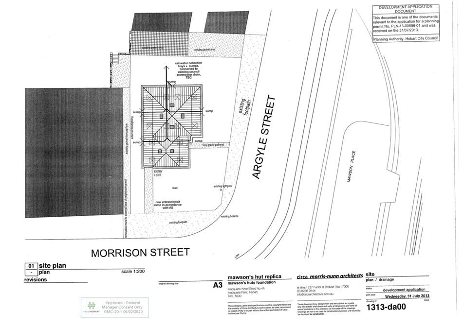
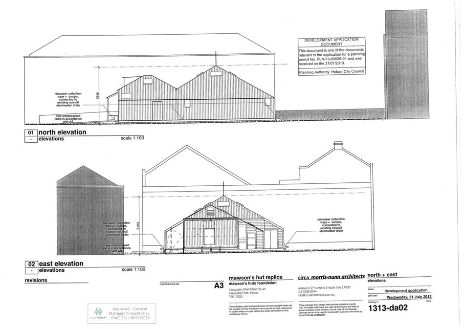
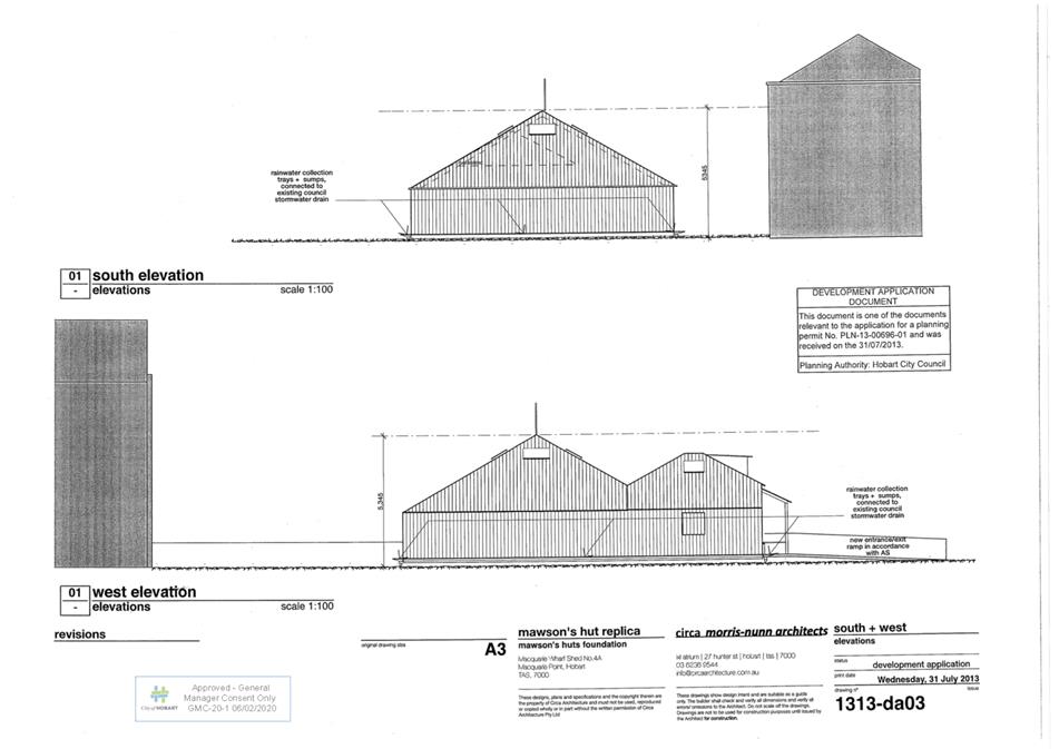
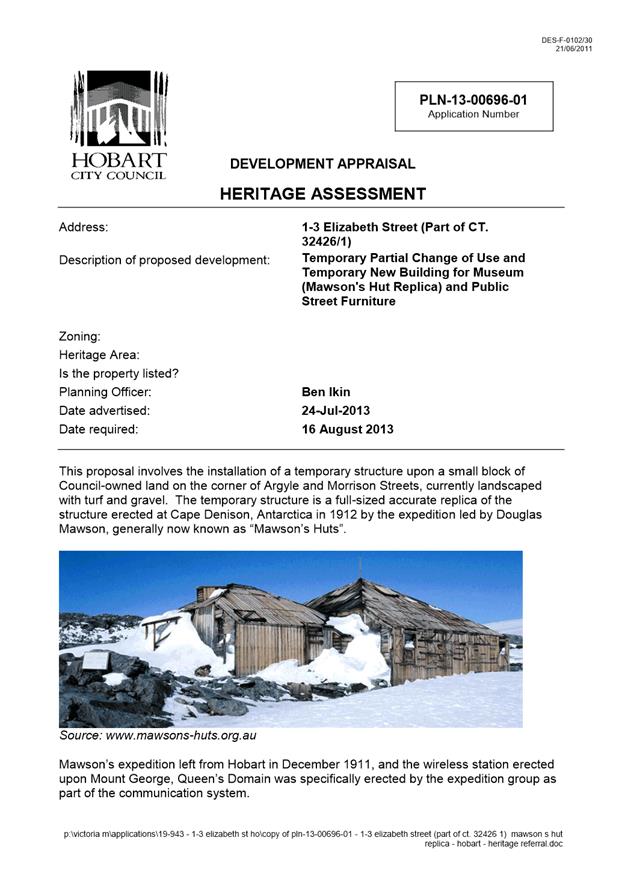
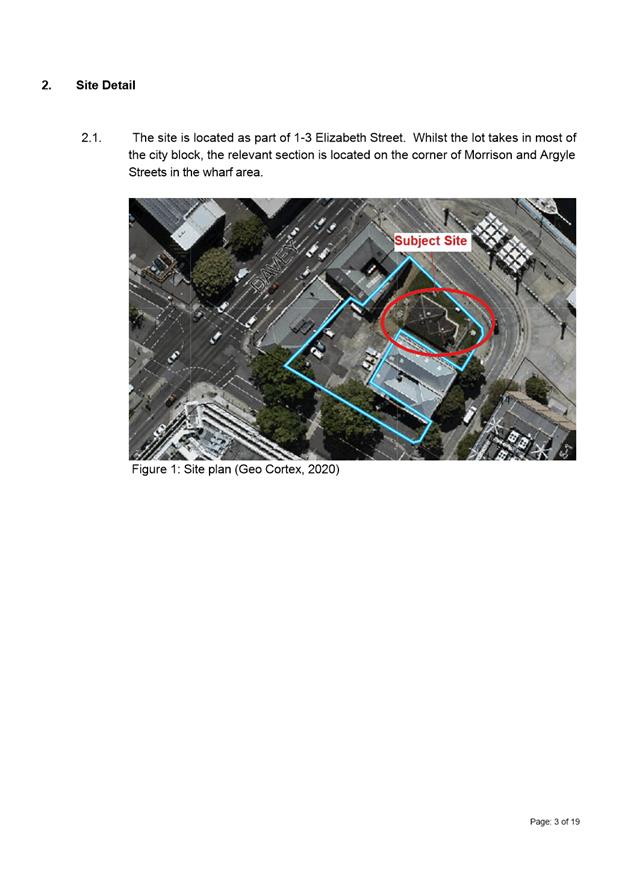
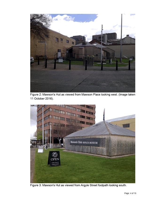
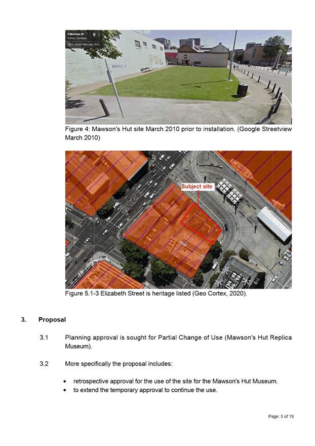
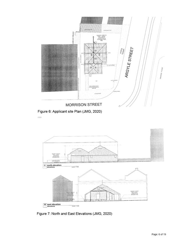
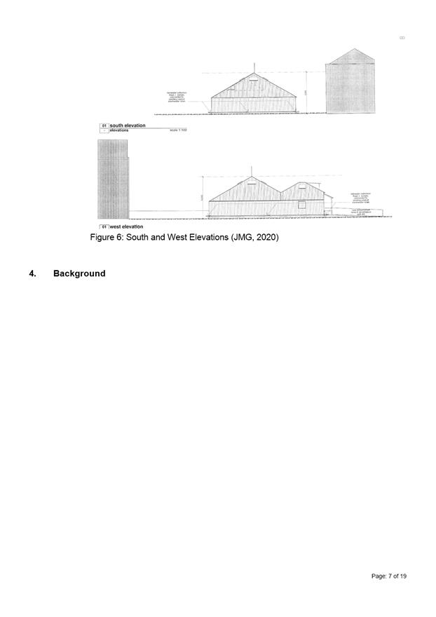
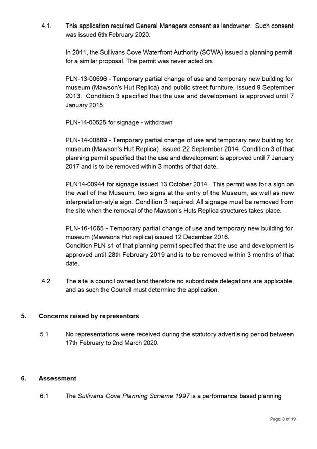
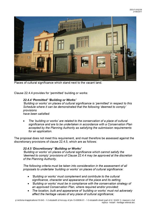
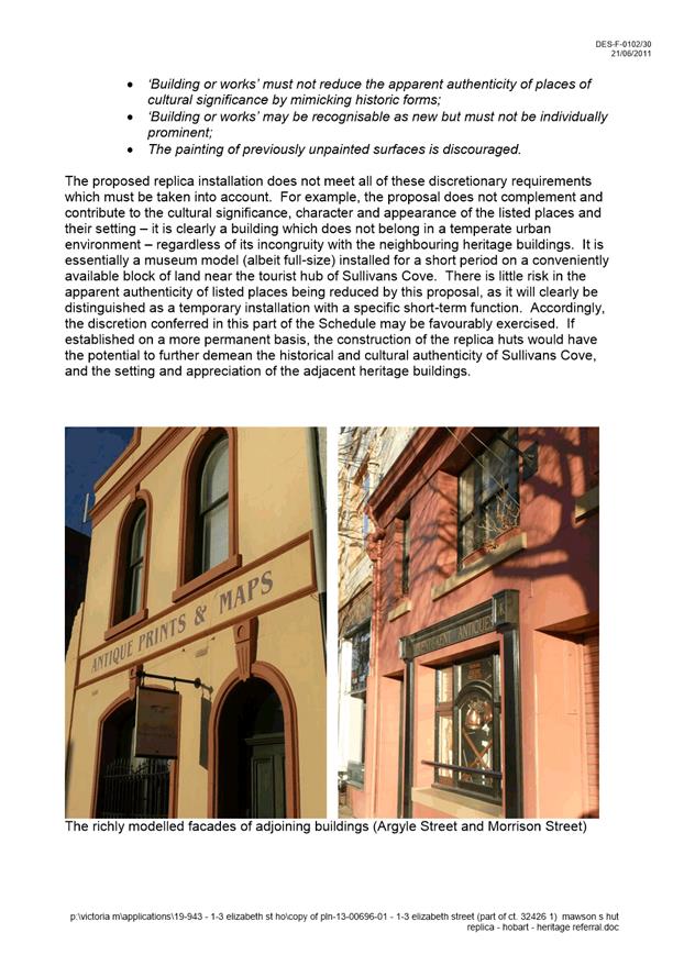
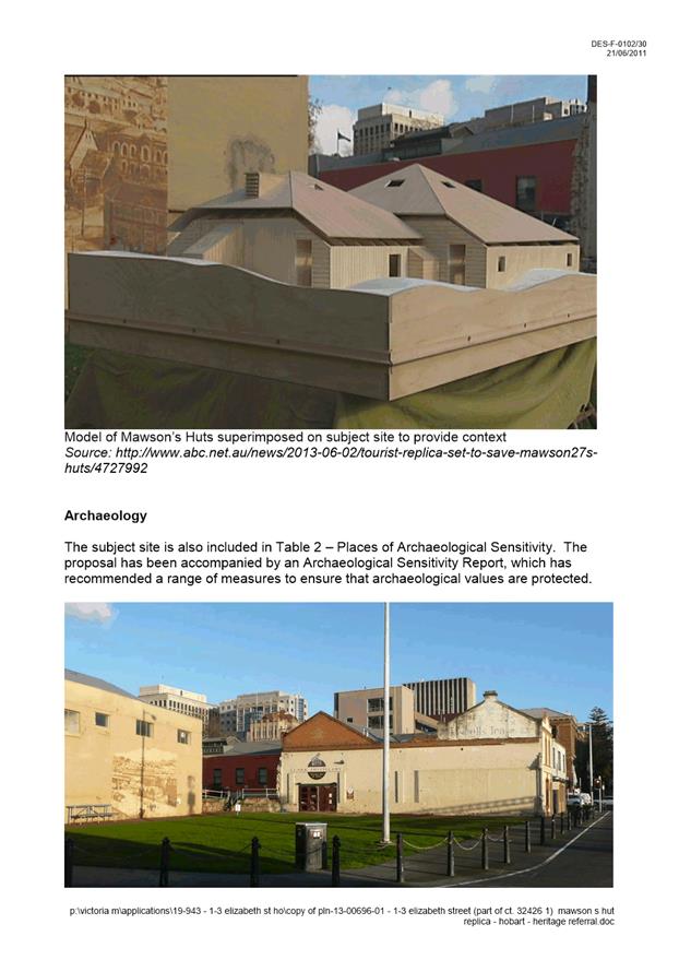
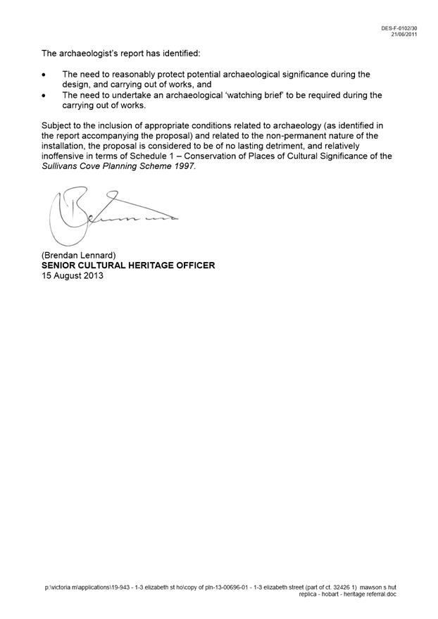
7.1.1 1-3 Elizabeth Street, Hobart - Partial Change of Use (Mawson's Hut Replica Museum)
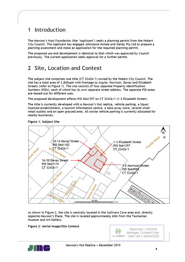
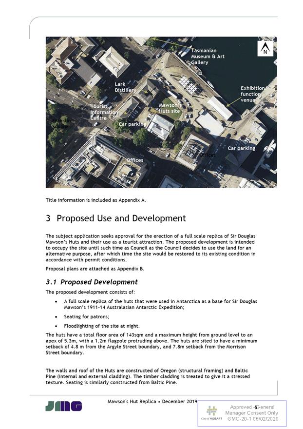
Address: 1-3 Elizabeth Street, Hobart
Proposal: Partial Change of Use (Mawson’s Hut Replica Museum)
Expiry Date: 30 April 2020
Extension of Time: Not applicable
Author: Victoria Maxwell
|
REcommendation That pursuant to the Hobart Interim Planning Scheme 2015, the Council approve the application for partial change of use (Mawson’s Hut Replica Museum) at 13 Elizabeth Street Hobart TAS 7000 for the reasons outlined in the officer’s report and a permit containing the following conditions be issued:
GEN
The use and/or development must be substantially in accordance with the documents and drawings that comprise PLN19943 13 ELIZABETH STREET HOBART TAS 7000 Final Planning Documents except where modified below.
Reason for condition
To clarify the scope of the permit.
THC
The use and/or development must comply with the requirements of the Tasmanian Heritage Council as detailed in the Notice of Heritage Decision, Works Application No. 6168 dated 3rd March 2020, as attached to the permit.
Reason for condition
To clarify the scope of the permit.
PLN 10
All signage must be removed from the site when the removal of the Mawson’s Huts replica structures takes place.
Reason for condition
To ensure that the signage is temporary only.
PLN s1
The proposed use and development is approved until 23 March 2022. After this time, the use must cease immediately, and within 3 months of that date, all buildings and associated structures must be removed and the site made good to its former state immediately prior to the commencement of the use and development.
Advice:
For the purposes of this condition, ‘immediately prior to the commencement of the use and development’ is taken to mean 9 September 2013.
Reason for condition
To clarify the scope of the permit.
PLN s2
The owner must pay the cost of any alterations and/or reinstatement to the Council’s infrastructure, incurred as a result of the proposed development works. Such payment is to be made within 60 days of the issue of a certificate of completion, or any demand, whichever is the latter.
Reason for condition
To ensure that any Council infrastructure affected by the proposal will be altered and/or reinstated at the owner’s full cost.
ADVICE
The following advice is provided to you to assist in the implementation of the planning permit that has been issued subject to the conditions above. The advice is not exhaustive and you must inform yourself of any other legislation, bylaws, regulations, codes or standards that will apply to your development under which you may need to obtain an approval. Visit the Council's website for further information.
Prior to any commencement of work on the site or commencement of use the following additional permits/approval may be required from the Hobart City Council.
BUILDING PERMIT
You may need building approval in accordance with the Building Act 2016. Click here for more information.
This is a Discretionary Planning Permit issued in accordance with section 57 of the Land Use Planning and Approvals Act 1993.
PLUMBING PERMIT
You may need plumbing approval in accordance with the Building Act 2016, Building Regulations 2016 and the National Construction Code. Click here for more information.
WASTE DISPOSAL
It is recommended that the developer liaise with the Council’s Cleansing and Solid Waste Unit regarding reducing, reusing and recycling materials associated with demolition on the site to minimise solid waste being directed to landfill.
Further information regarding waste disposal can also be found on the Council’s website.
FEES AND CHARGES
Click here for information on the Council's fees and charges.
DIAL BEFORE YOU DIG
Click here for dial before you dig information.
PUBLIC CONVENIENCES
The applicant be advised to provide information regarding public conveniences located nearby to patrons.
|
Attachment a: PLN-19-943
- 1-3 ELIZABETH STREET HOBART TAS 7000 - Planning Committee or Delegated Report ⇩ ![]()
Attachment
b: PLN-19-943
1-3 ELIZABETH STREET HOBART TAS 7000 -CPC Agenda Documents ⇩ ![]()
Attachment
c: PLN-19-943
- 1-3 ELIZABETH STREET HOBART TAS 7000 -Planning Referral Officer Cultural
Heritage Report ⇩ ![]()
Attachment
d: PLN-19-943
1-3 ELIZABETH STREET HOBART TAS 7000 - Senior Cultural Heritage Officer Report
for PLN-13-00696-01 ⇩ ![]()
|
Item No. 7.1.1 |
Agenda (Open Portion) City Planning Committee Meeting - 16/3/2020 |
Page 30 ATTACHMENT a |
|
Agenda (Open Portion) City Planning Committee Meeting - 16/3/2020 |
Page 62 ATTACHMENT b |
|
Agenda (Open Portion) City Planning Committee Meeting - 16/3/2020 |
Page 74 ATTACHMENT c |

|
Agenda (Open Portion) City Planning Committee Meeting - 16/3/2020 |
Page 83 ATTACHMENT d |
|
Agenda (Open Portion) City Planning Committee Meeting |
Page 84 |
|
|
|
16/3/2020 |
|
7.2 Applications under the Hobart Interim Planning Scheme 2015
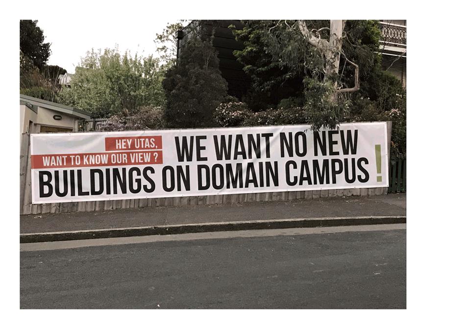
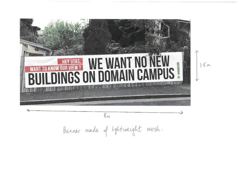
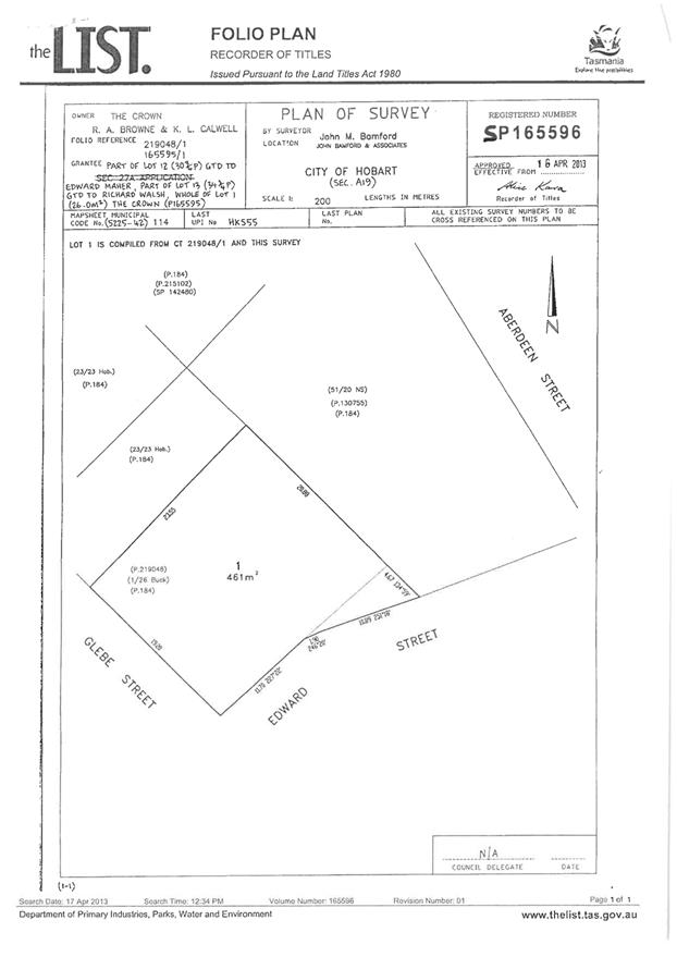
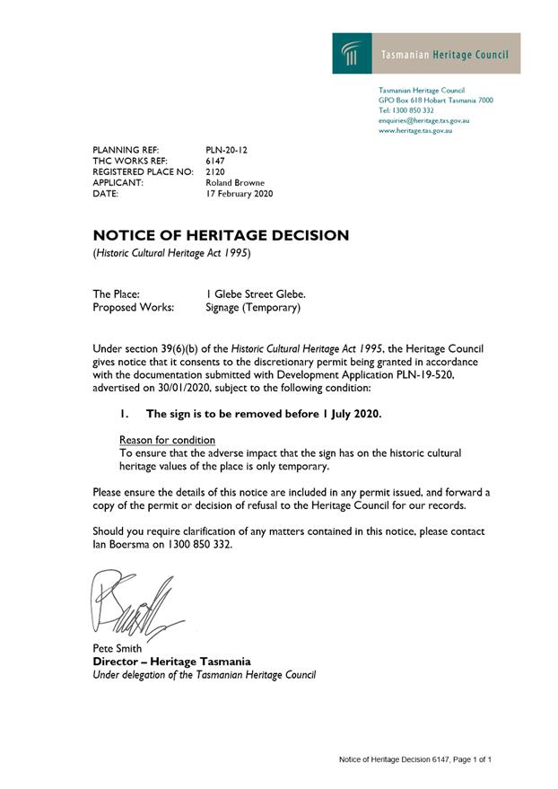
7.2.1 1 Glebe Street, Glebe - Sign
Address: 1 Glebe Street, Glebe
Proposal: Sign
Expiry Date: 6 April 2020
Extension of Time: Not applicable
Author: Michelle Foale
|
REcommendation That pursuant to the Hobart Interim Planning Scheme 2015, the Council refuse the application for a sign at 1 Glebe Street, Glebe for the following reasons:
1 The proposal does not meet the acceptable solution or the performance criterion with respect to clauses E17.6.1 and E17.7.1 Standards for Signs of the Hobart Interim Planning Scheme 2015 because a banner sign is prohibited in the inner residential zone.
|
Attachment a: PLN-20-12
- 1 GLEBE STREET GLEBE TAS 7000 - Planning Committee or Delegated Report ⇩ ![]()
Attachment
b: PLN-20-12
- 1 GLEBE STREET GLEBE - CPC Agenda Documents ⇩ ![]()
|
Item No. 7.2.1 |
Agenda (Open Portion) City Planning Committee Meeting - 16/3/2020 |
Page 92 ATTACHMENT a |
|
Agenda (Open Portion) City Planning Committee Meeting - 16/3/2020 |
Page 94 ATTACHMENT b |
|
Agenda (Open Portion) City Planning Committee Meeting |
Page 100 |
|
|
|
16/3/2020 |
|
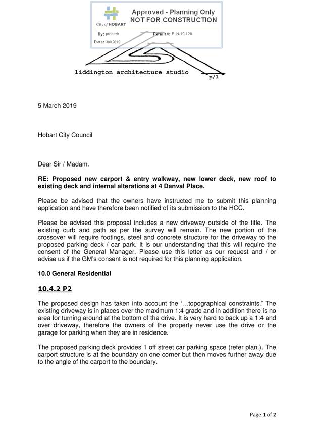
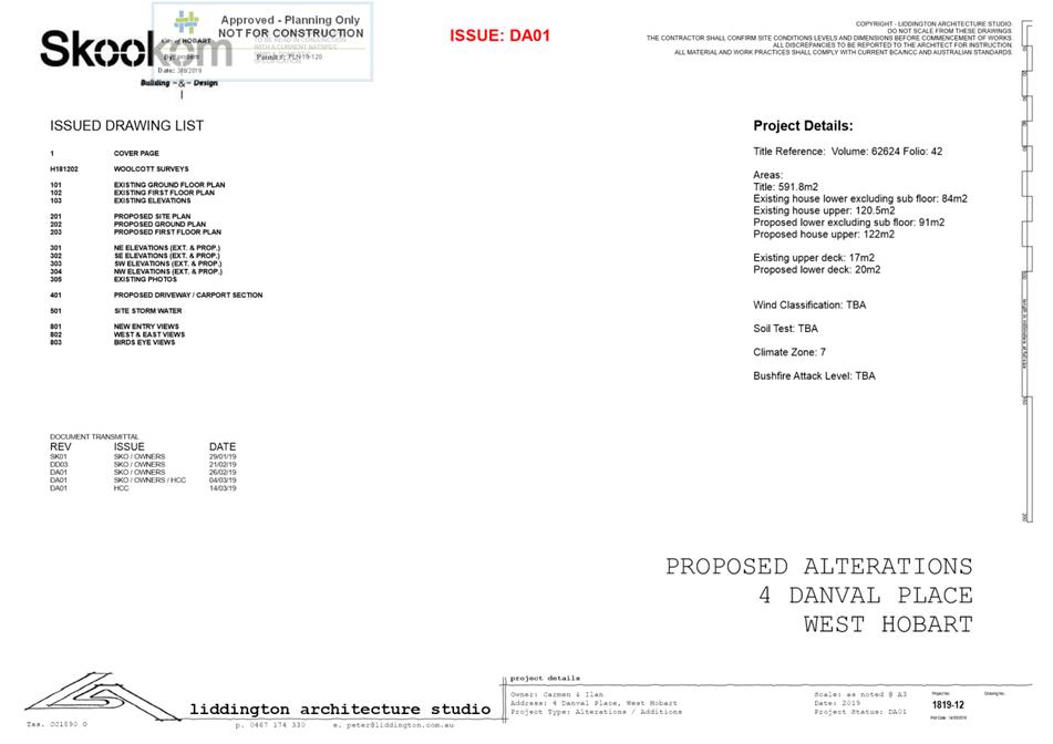
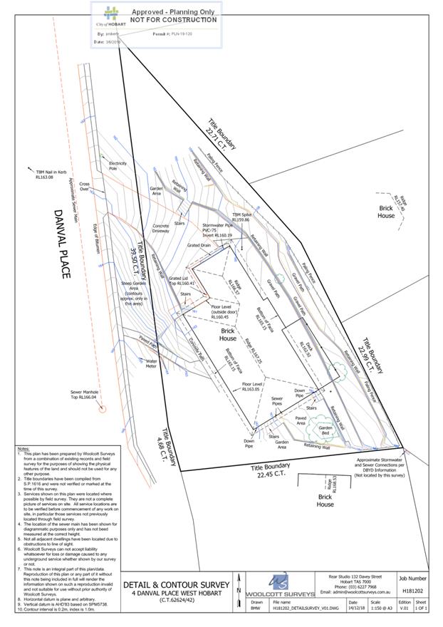
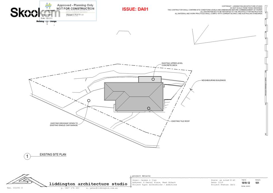
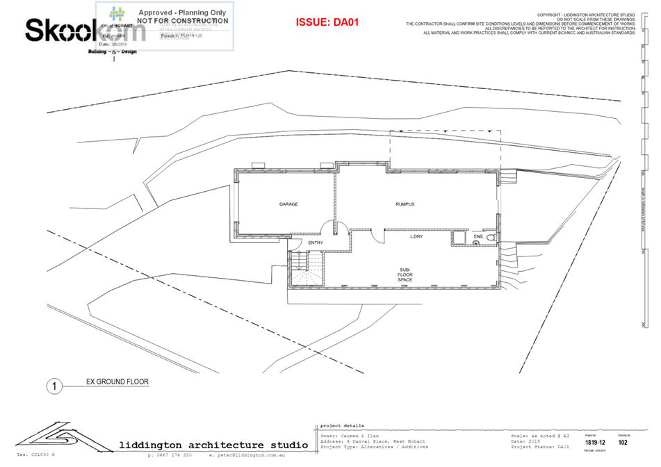
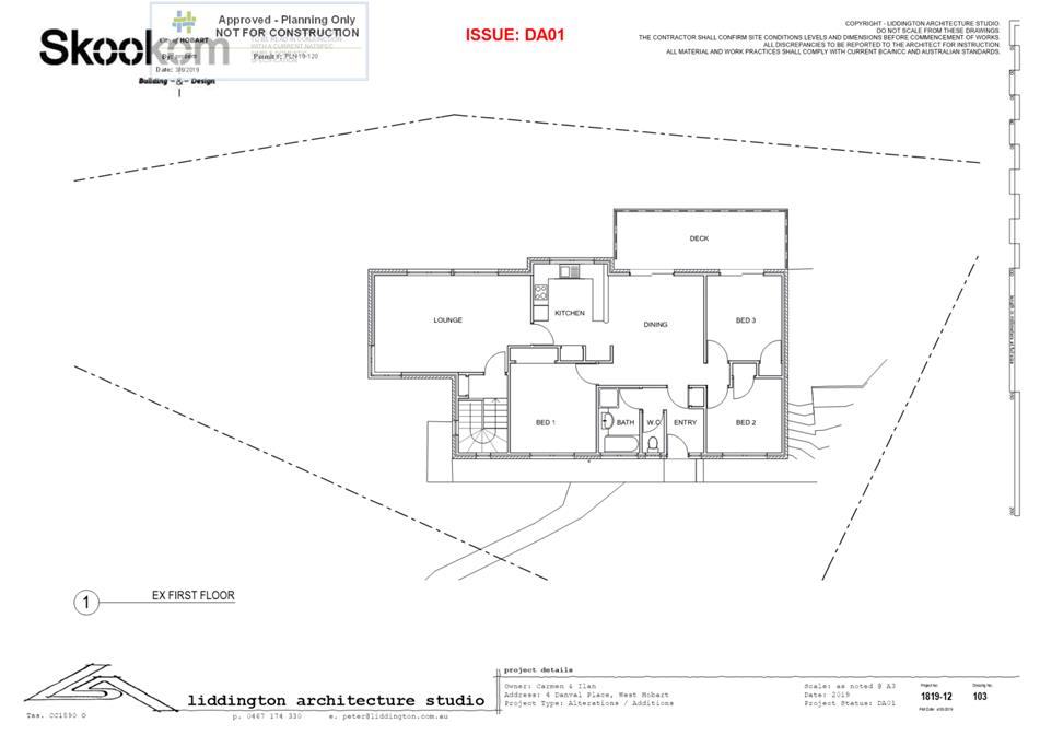
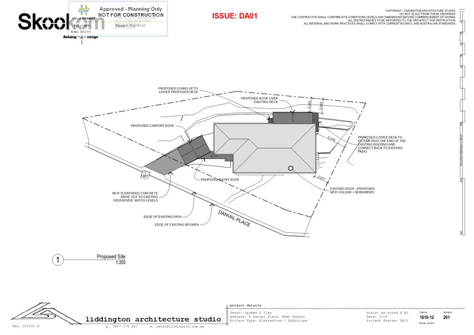
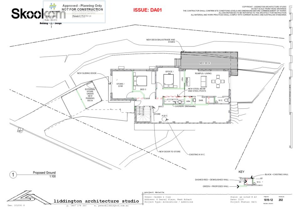
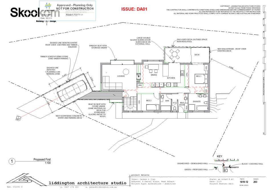
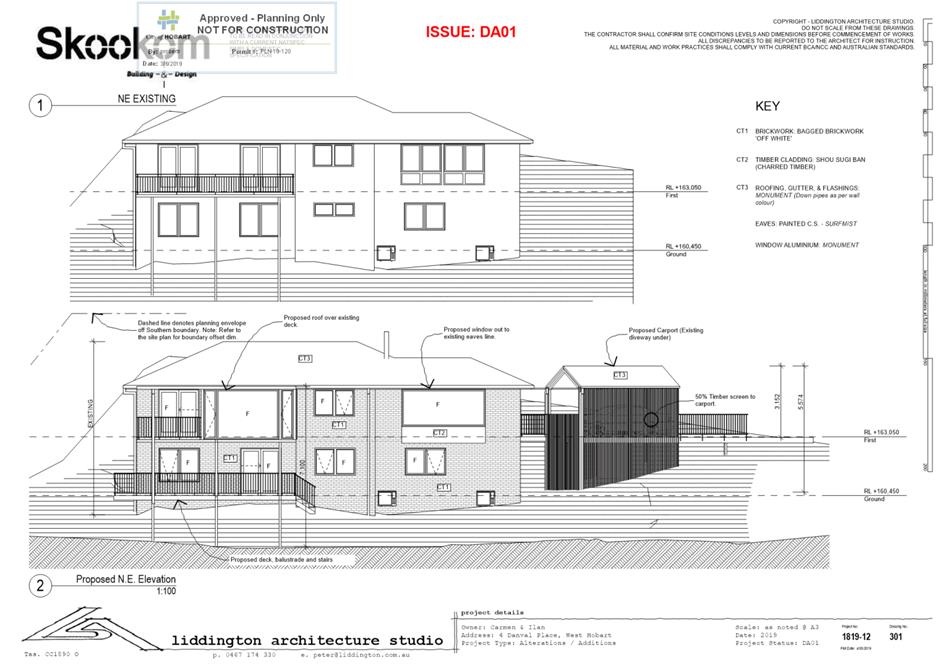
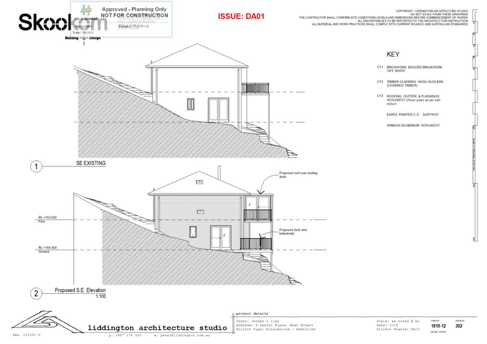
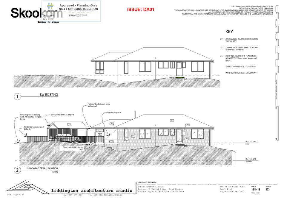
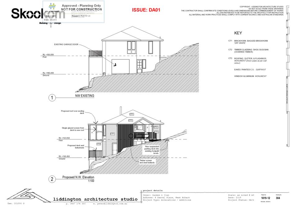
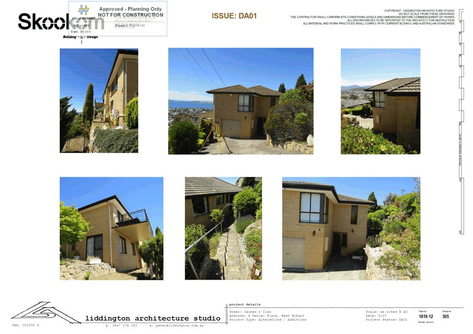
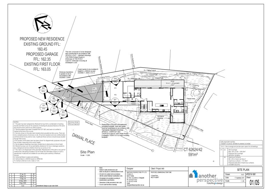
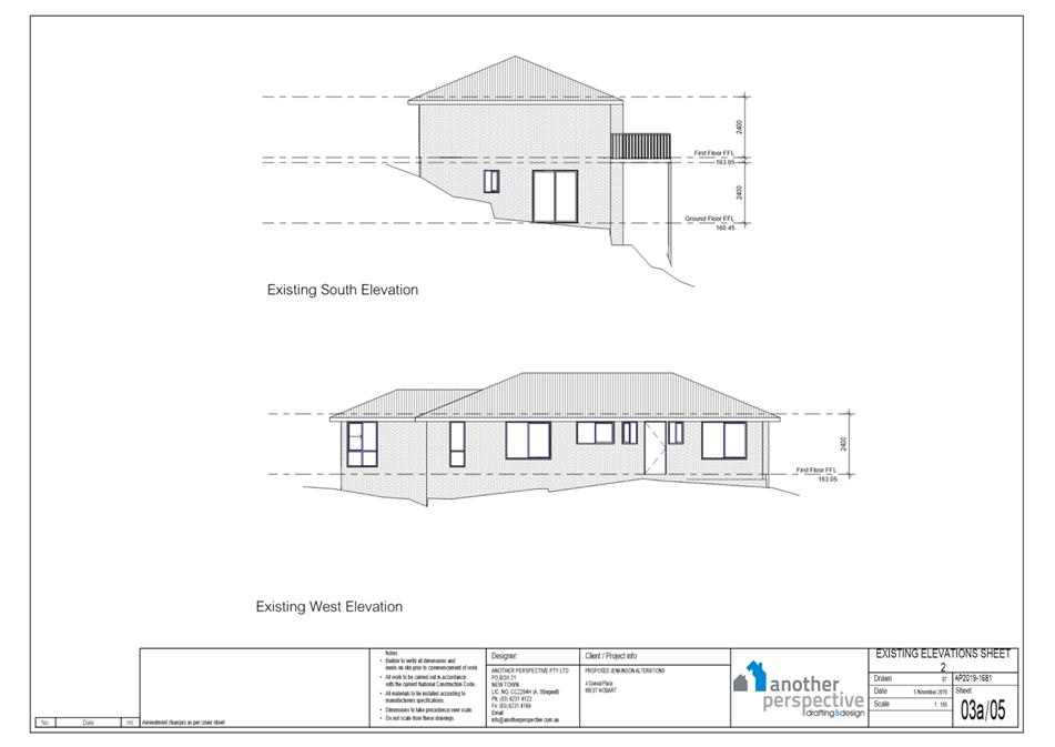
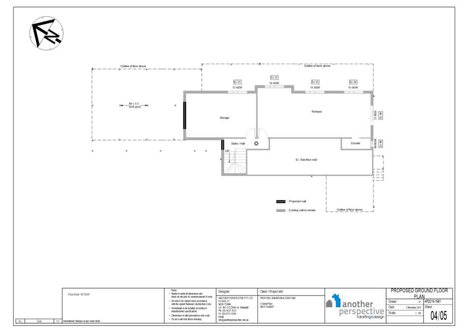
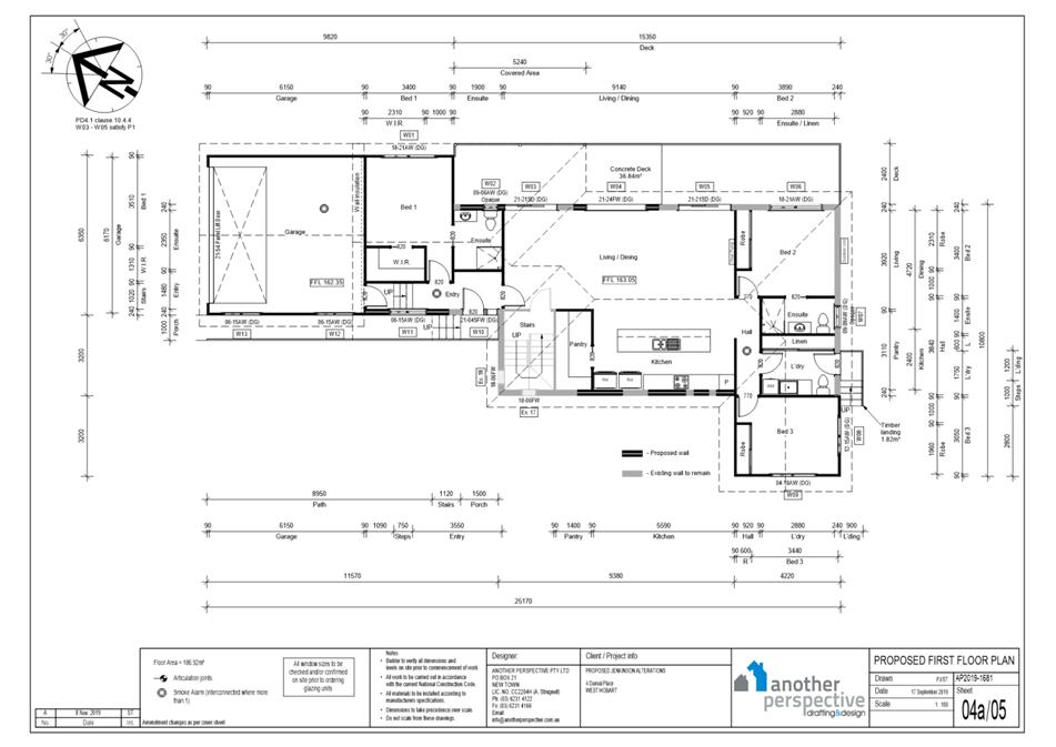
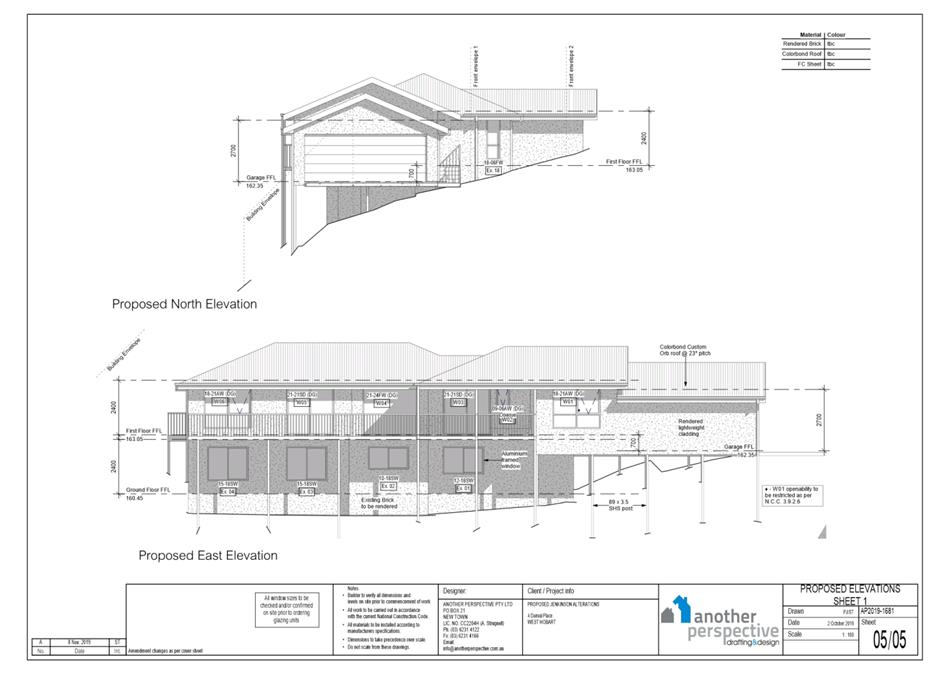
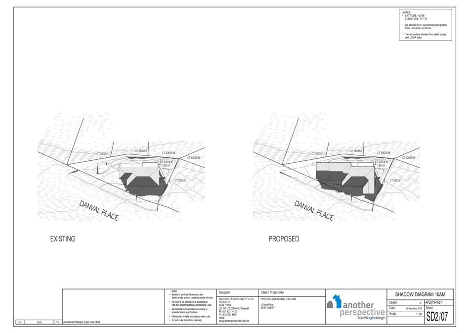
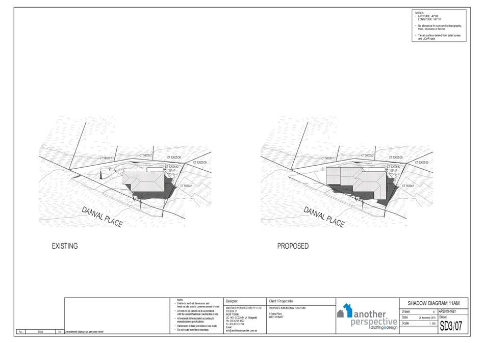
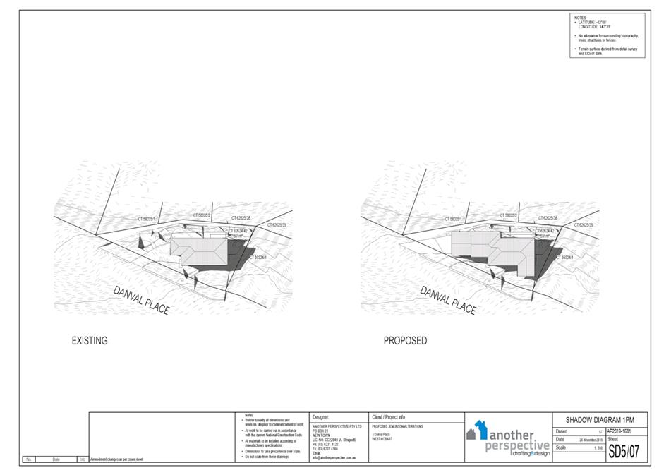
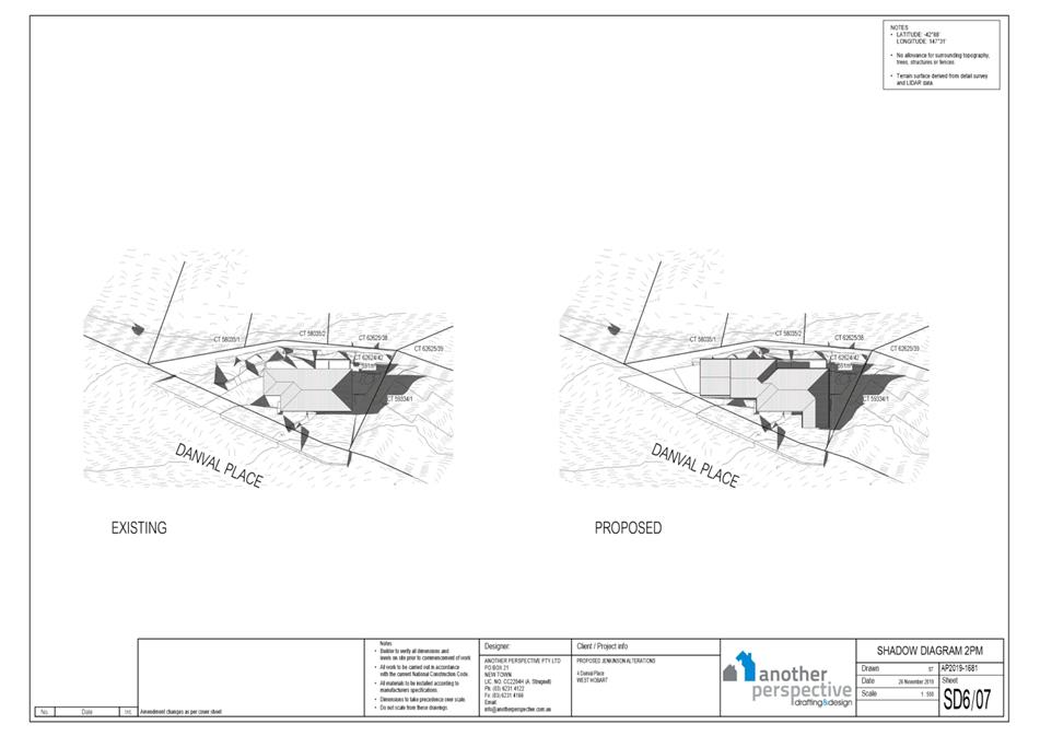
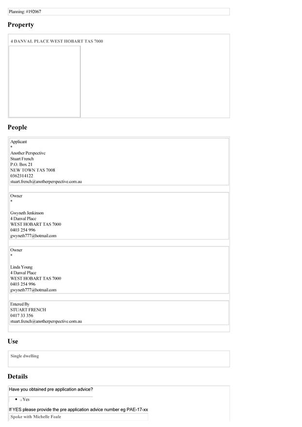
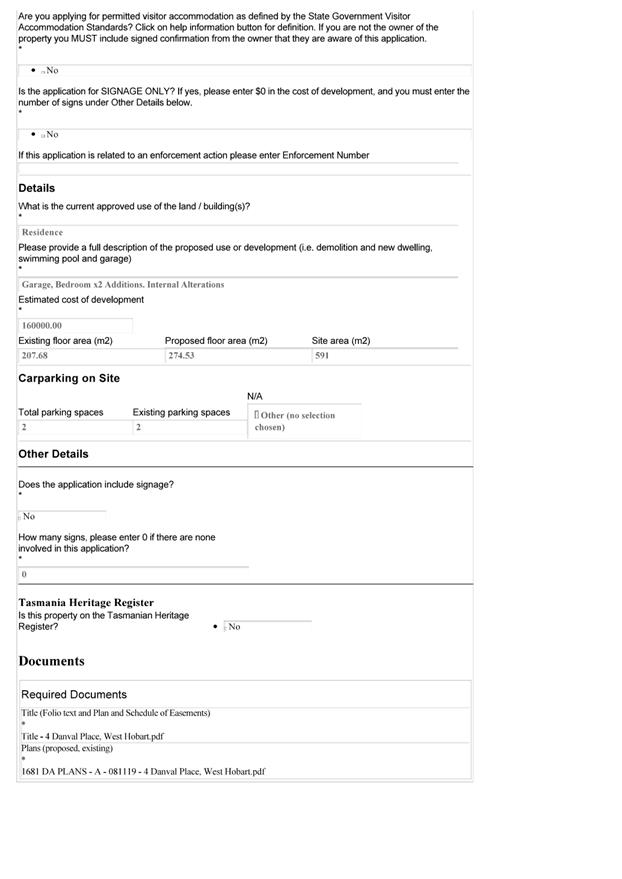
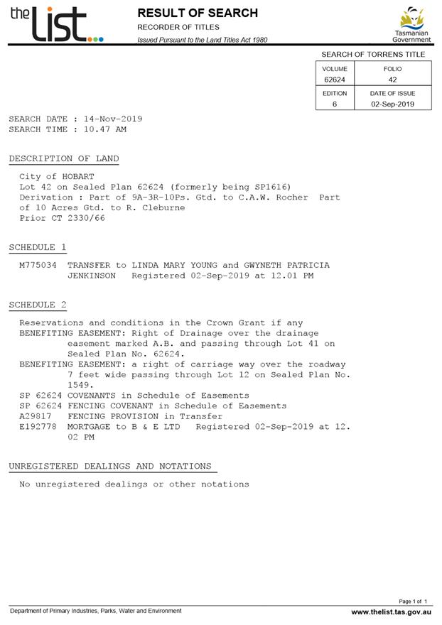
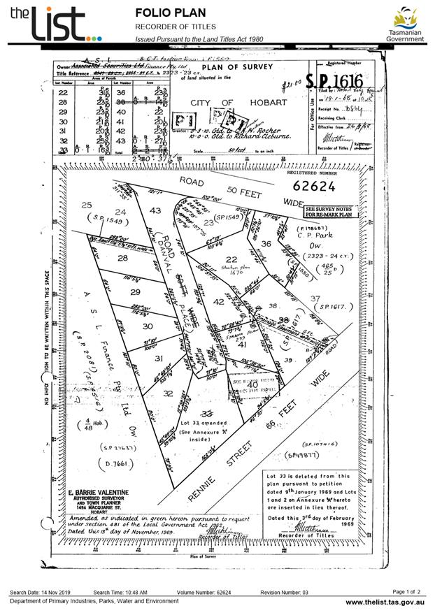
7.2.2 PLN-19-818 4 Danval Place, West Hobart
Memorandum of the Manager Development Appraisal of 11 March 2020 and attachments.
Delegation: Council
|
Item No. 7.2.2 |
Agenda (Open Portion) City Planning Committee Meeting |
Page 119 |
|
|
16/3/2020 |
|

Memorandum: City Planning Committee
PLN-19-818 4 Danval Place, West Hobart
Background
At its 17 February 2020 meeting, the City Planning Committee (the Committee) considered development application PLN-19-818 for Partial Demolition, Extension and Alterations, at 4 Danval Place, West Hobart. The Committee resolved as follows:
That the item be deferred to enable officers to further investigate the application.
Typographical Error
On page 8 of the Committee report for the current application PLN-19-818 at paragraph 4.1 it is stated that:
The dwelling was previously approved for partial demolition, alterations, extensions and carport under PLN-19-120. The application was for a modest proposal and attracted two objections. It was approved under delegation.
The portion underlined is incorrect. While the application did not attract enough objections to trigger Committee or Council determination, the proposal included works in the Council’s road reserve and was therefore approved by the Council on 3 June 2019.
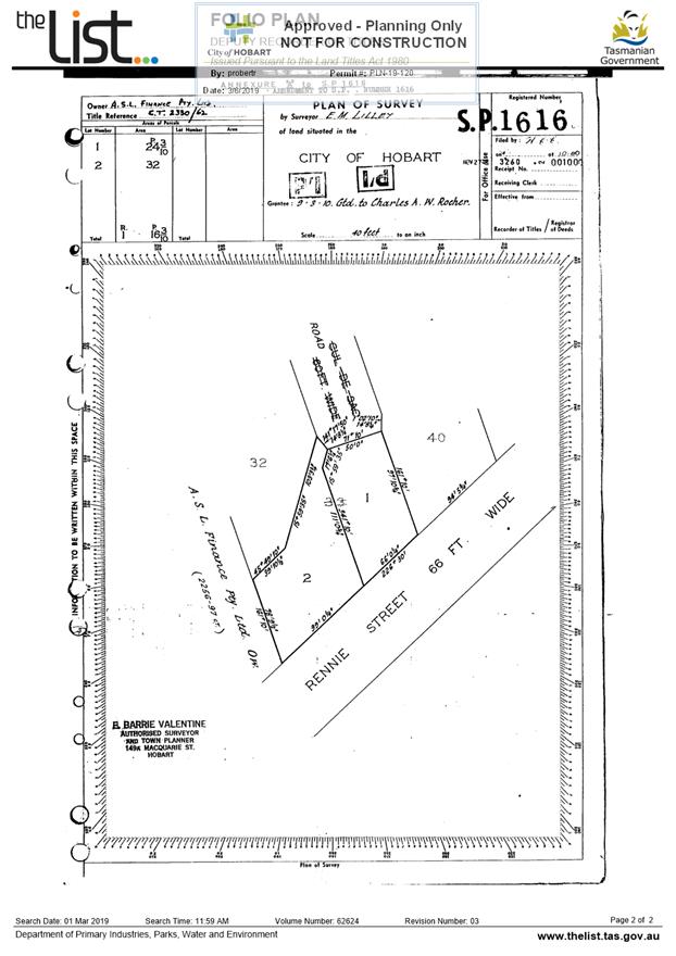
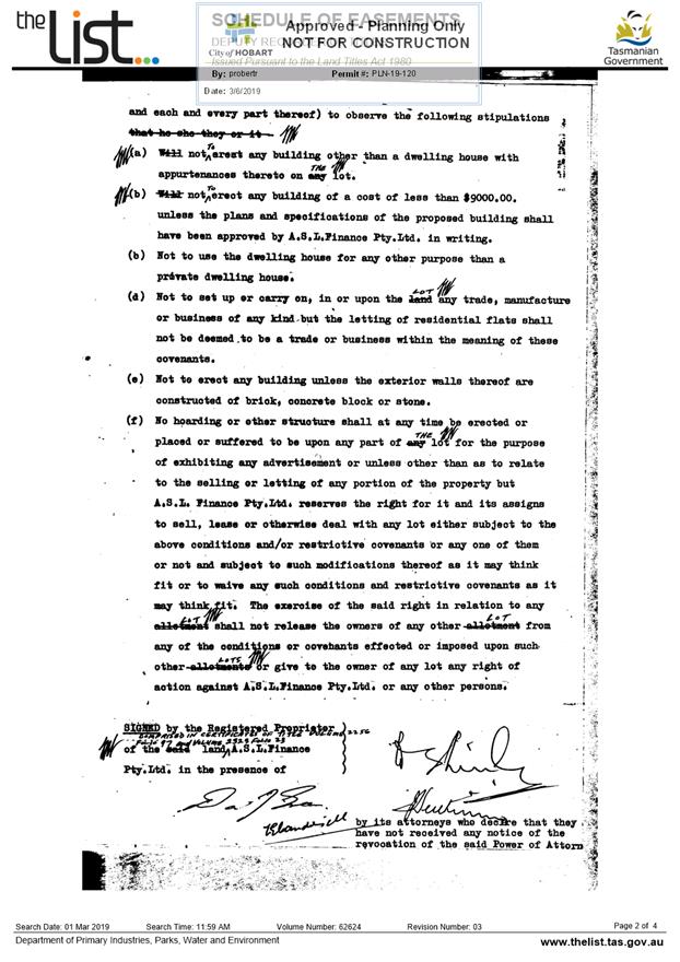
Development Application PLN-19-120
This application was submitted by the
previous owners of the site. It was for:
· A carport and car parking deck (with footings and structures in road reserve) with storage below;
· A new lower level deck, existing upper deck partially enclosed and roofed;
· A slight increase in floor areas on both levels, additional approximately 9sqm in total; and
· A rearrangement of rooms on both levels, new front door on upper level accessed via covered pedestrian walkway from car deck to dwelling.
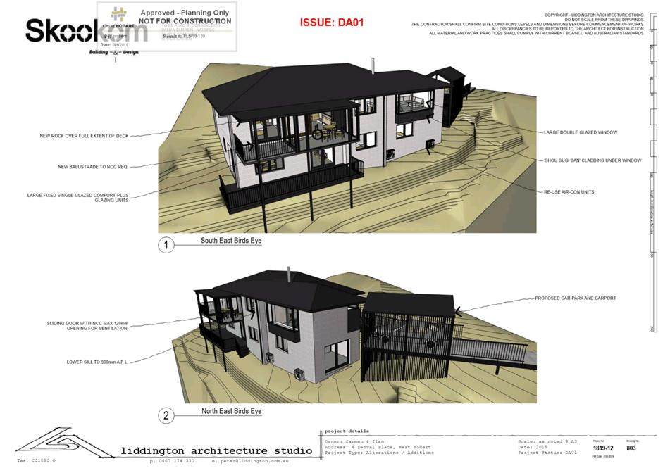
The plans of the approved development are provided at Attachment A to this memorandum. The image below shows three renders of the approved development.
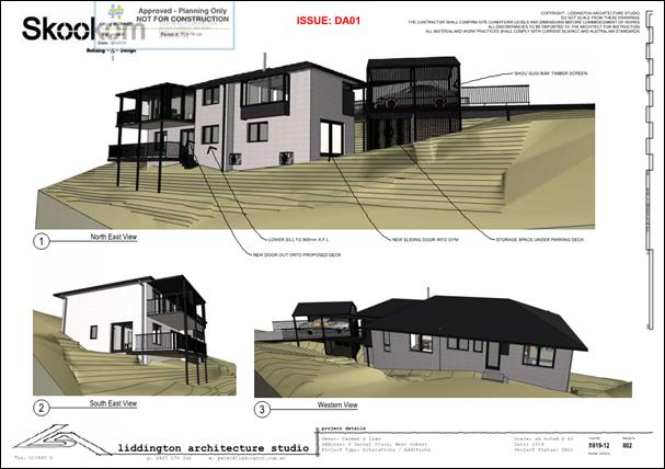
Figure 1: Renders of the approved development under PLN-19-120.
In assessing the development the officer included the following comments in relation to the carport element:
All of the dwellings in this street have internal garages. This dwelling has an internal garage that is proposed to be converted to habitable rooms with this proposal. In conjunction with clause D10.4.2 P1 above, it is considered reasonable to require the applicant to reduce the bulk of the proposed car port as it would be an anomalous building in the streetscape and representors have raised objections.
Therefore a condition is recommended for the roof design to be made a single plane / skillion, and the timber slats proposed on the north eastern elevation of the car port are to be reduced to be only below the standard balustrade.
It is agreed with the representors that the design of the car port is too high and solid a condition is recommended to reduce the size and bulk of this structure.
The following condition was included on the permit:
PLN s4
The carport must be reduced in height and bulk.
Prior to the issue of any approval under the Building Act 2016, revised plans must be submitted and approved to the satisfaction of the Director City Planning, in accordance with the above requirements. The revised plans must show the following:
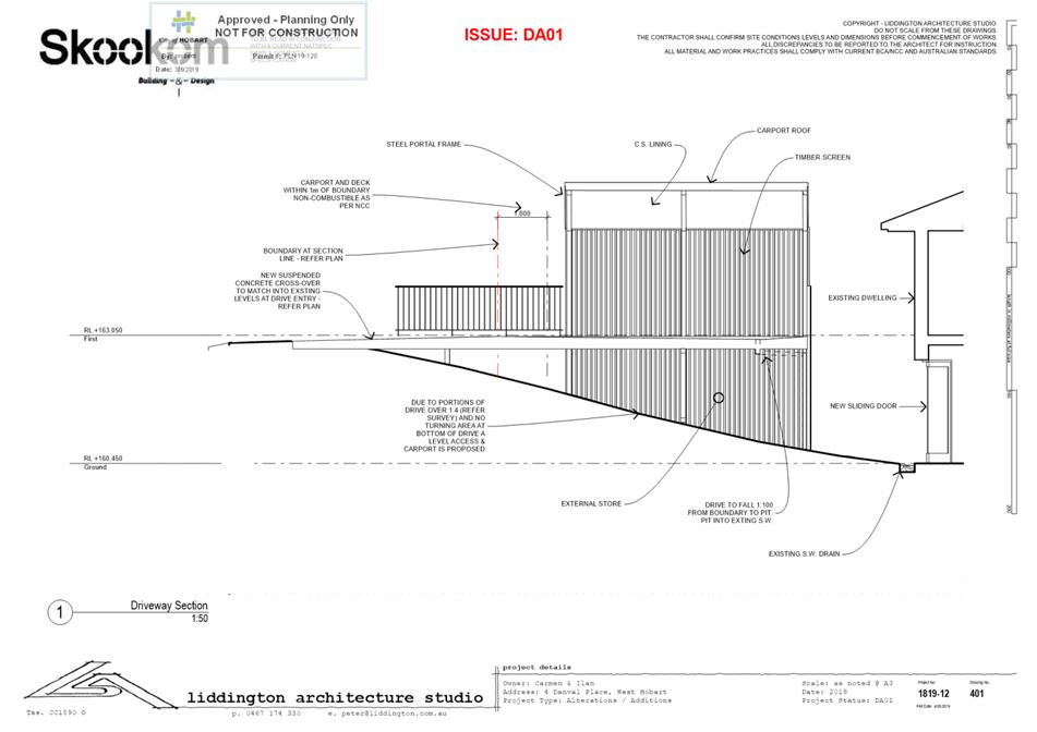
1. The carport roof design must be a single plane/skillion design with a maximum height of no more than 2.7m from the car parking deck level (RL+163 050); and
2. The timber slats on the north eastern elevation of the car port must be only below the standard balustrade.
All work required by this condition must be undertaken in accordance with the approved revised plans.
Reason for condition
To provide relative consistency in the apparent scale, bulk, massing and proportion of dwellings (and outbuildings) in the area.
The planning permit was not acted on, but remains valid until 3 June 2021 (unless extended with the approval of the Council). The site has been sold to the current owners who are seeking a new approval under PLN-19-818.
Development Application PLN-19-818
This is the application currently before the
Committee for consideration. The Committee report and plans are provided at
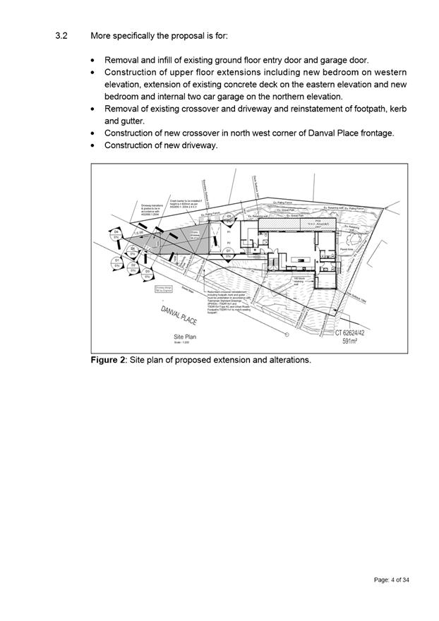
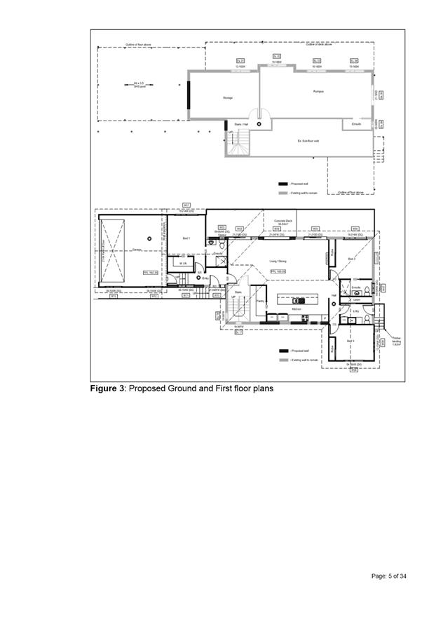
Attachment B to this memorandum. The application proposes:
· Removal and infill of existing ground floor entry door and garage door.
· Construction of upper floor extensions including new bedroom on western elevation, extension of existing concrete deck on the eastern elevation and new bedroom and internal two car garage on the northern elevation.
· Removal of existing crossover and driveway and reinstatement of footpath, kerb and gutter.
· Construction of new crossover in north west corner of Danval Place frontage.
· Construction of new driveway.
This proposal does not include any works in the Council’s road reserve requiring General Manager consent.
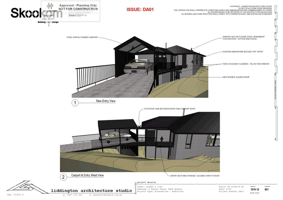
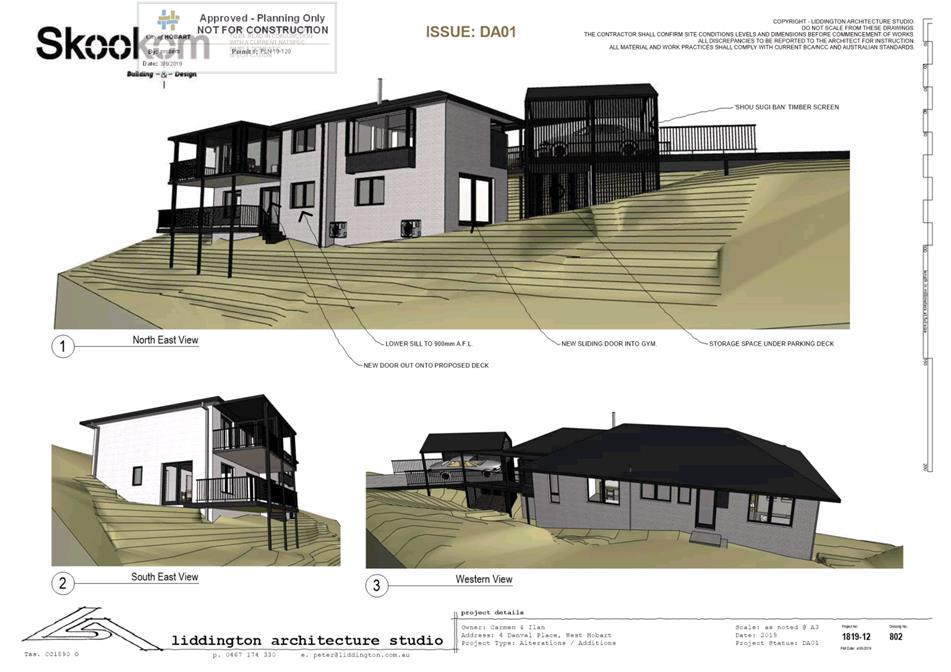
The image below shows two renders of the proposal:
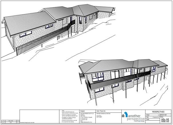
Figure 2: Renders of the proposed development in PLN-19-818.
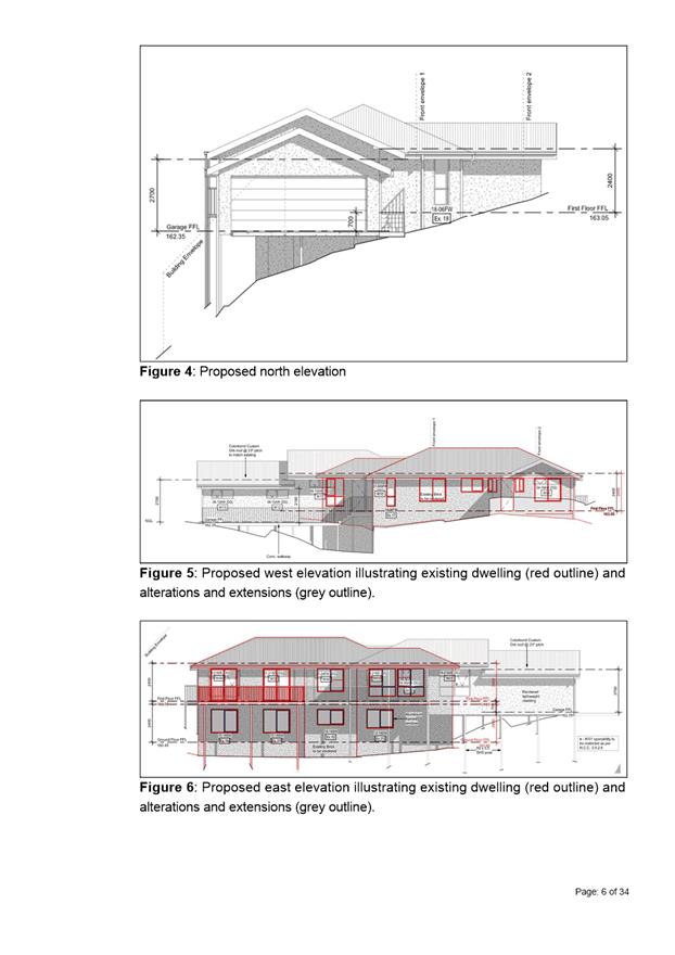
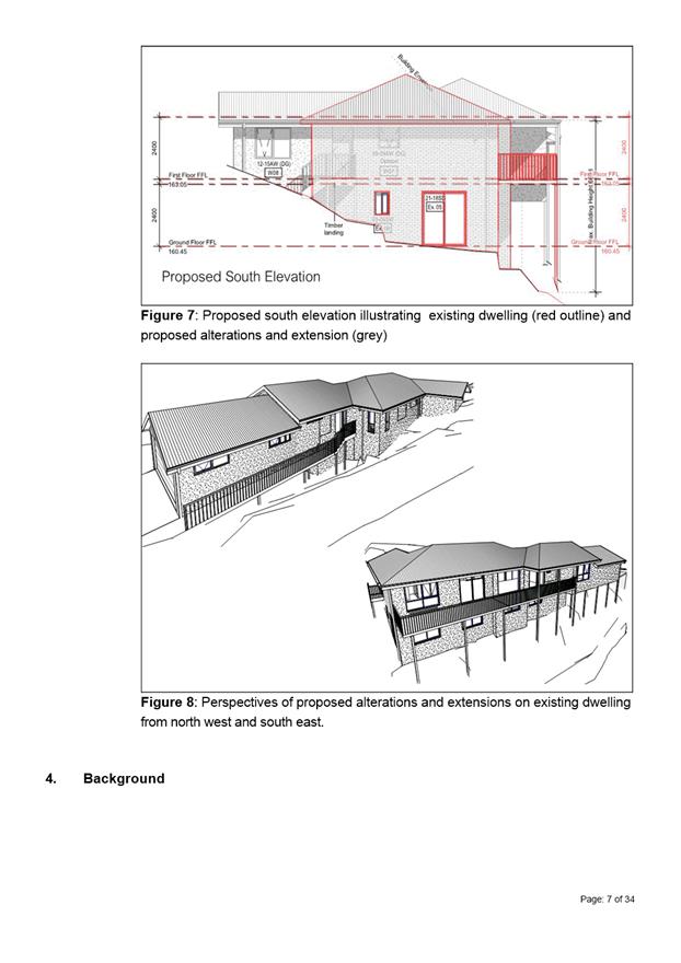
No conditions have been recommended in relation to the form or appearance of the garage. The primary reason for this is that the proposed garage is integral to the dwelling, rather than a stand alone element like the car port was in the previous application. The assessment of the previous application made the point that dwellings in the street have internal garages, and as such a car port would be an anomolous feature in the streetscape and thus required conditioning to reduce its presence in that streetscape. In contrast, the current proposal, while set forward of the existing dwelling, is an integral garage more in keeping with other dwellings in the street. As such, it will not appear as an anomolous feature in the streetscape. This difference can be seen in the site plans below, as well as the renders above.
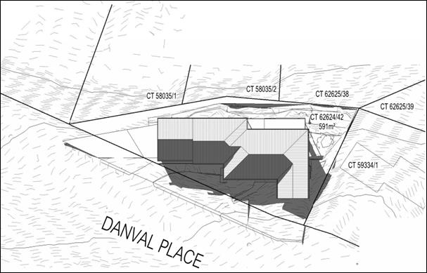
Figure 3: The above image is a site plan of the current proposal, showing the garage as an integral component of the dwelling, like others in the street.
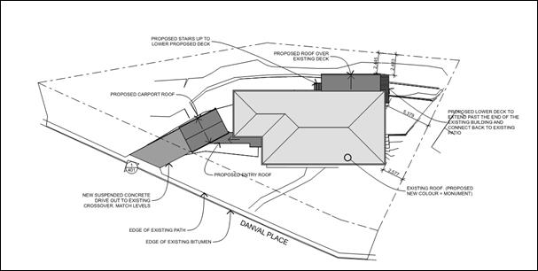
Figure 4: The above image is a site plan of the previoulsy approved proposal, showing the carport as a separate element to the house, unlike other dwellings in the street.
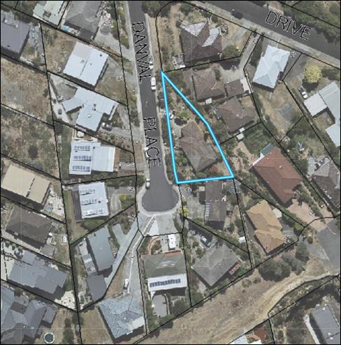
Figure 5: The building pattern of Danval Place, showing the lack of stand alone car ports. The proposed garage would read as an extension to the existing dwelling at 4 Danval Place, which is bordered in blue.
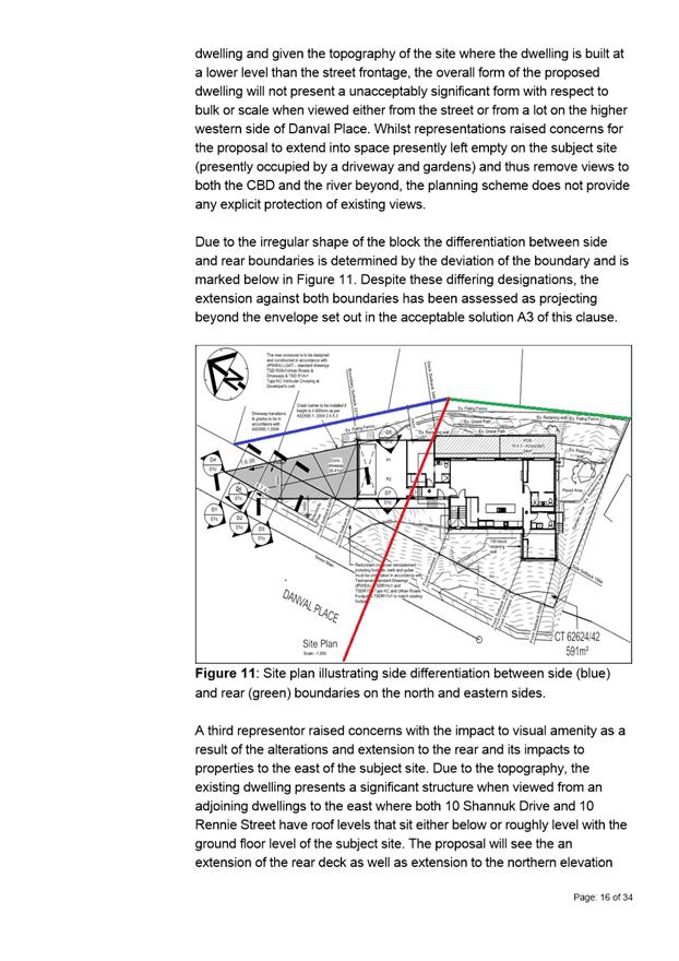
The Committee report deals comprehensively with why the siting of the proposed garage forward of the existing dwelling is acceptable, noting the position of this dwelling on the lower side of the street, below street level, the steep topography of the site, and the irregularity of the lot shape. Similarly it sets out clearly why (so far as matters relevant to the planning scheme are concerned) there is no unreasonable impact on neighbour’s residential amenity as a consequence of the proposed garage.
In terms of the height and form of the garage it is noted that its ridgeline is set down from the main dwelling, but that the form matches that of the main dwelling. This means the garage reads as an integral component of the dwelling, but has a lesser built form and therefore visual impact than if it matched the ridge height of the main dwelling.
It is also noted that the minimum setback of the garage is 1.09m and the maximum setback is 6.88m, in comparison to the car port which had a minimum setback of 0m and maximum setback of 2.3m. The increased setback of the garage also helps to lessen its visual impact.
Reducing the height of the garage, or changing its roof form, were ideas discussed with the applicant. The applicant’s response to whether they would be supportive of a similar to condition to that imposed on the previous application is set out below:
The maximum height of the proposed structure at the northern end (the ridge of the garage roof) is 3.905m (measured from the garage floor level). Measured from the existing first floor level (the 163.050 RL number mentioned in the previous condition), the max height is 3.205m above. Whilst this is 0.505m above the 2.7m condition imposed in the previous application, as we have all stated previously we believe this is still not unreasonable, and has in fact already been reduced (from the original brief of providing level access from the garage), in order to minimise the impact on the visual amenity of the neighbours across the road.
Were we to change to a single plane/skillion roof of some description, we believe it would look less than ideal. Part of what we have tried to do from day one is make the design fit with the existing structure to avoid it standing out like an add on. We believe what we have currently done does fit in with the existing style of roof and house, and altering the roof style would make it look like an add on, and in many ways, would end up with the exact thing that the representors were arguing against last time – something that stands out by not fitting in.
One of the main points of the original design brief for the proposed changes was the provision of an enclosed and secure garage attached to the main dwelling. Opening the sides of the garage and turning it into a carport would mean it was no longer secure. As such, this is not a viable alternative.
The stated reason for the condition was ‘To provide relative consistency in the apparent scale, bulk, massing and proportion of dwellings (and outbuildings) in the area’.
Whilst this reasoning made perfect sense when assessing a carport for which there were no others similar in the street, the proposed design presented as part of this application (an extension to the existing dwelling in the same style) meets each of these criteria, both in respect to the existing dwelling and to the area in general.
Taking all that into account, our position in response to these conditions would be that the development as currently proposed is not an unreasonable one. The proposed changes fit with the existing character of the house and street in general, the houses on the other side of the road are elevated and look over our existing roof, and would continue to look over the extended roof. We believe that the resulting visual impact on neighbours is minimal and will present only as a foreground element that does not block any wider city or water view.
As such, we would consider that these conditions are unnecessary to the proposed development and we would not support them as they stand currently.
Compliance with clause 10.4.2 A2(c)
Clause 10.4.2 A2(c) allows a garage to have a 1m setback (rather than a 5.5m setback) from the road frontage if the natural ground level slopes up or down at a gradient steeper than 1:5 (20%) for a distance of 10m from the frontage. In the Committee report it was assessed that the proposal did not comply with this acceptable solution because the slope was calculated to be 20%, but not steeper.
The applicant has provided a plan (at Attachment C to this memorandum) which demonstrates that the slope is 51%, and therefore compliance with the acceptable solution is attained because the garage has a minimum setback of over 1m from the road frontage. This supports the position taken in the Committee report that the siting of the garage is appropriate, taking into account the steepness of the site.
Expiry Date
The current planning application PLN-19-818 is set to expire on 27 March 2020. However the applicant has provided an extension of time until 8 May 2020.
Conclusion
The proposal is considered acceptable as depicted in the development application without the need to condition to reduce the height or change the form of the garage. This is not considered to be inconsistent with the previous approval for (among other things) a carport, given the differences between these two elements and the characteristics of the site and street.
However, noting the discretions invoked by the proposal, the Committee would have the power to impose a condition in relation to the height and/or form of the garage if they were of a mind to.
|
That:
Pursuant to the Hobart Interim Planning Scheme 2015, the Council approve the application for Partial Demolition, Extension and Alterations at 4 Danval Place, West Hobart for the reasons outlined in the officer’s report and a permit containing the following conditions be issued:
GEN
The use and/or development must be substantially in accordance with the documents and drawings that comprise PLN-19-818 - 4 DANVAL PLACE WEST HOBART TAS 7000 - Final Planning Documents except where modified below.
Reason for condition
To clarify the scope of the permit.
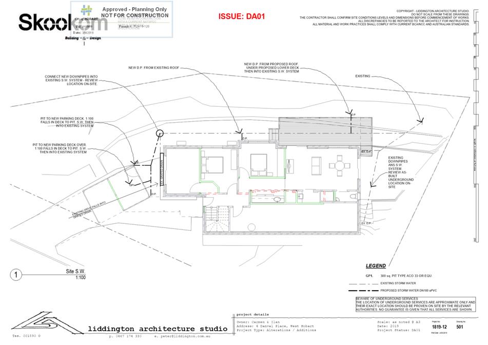
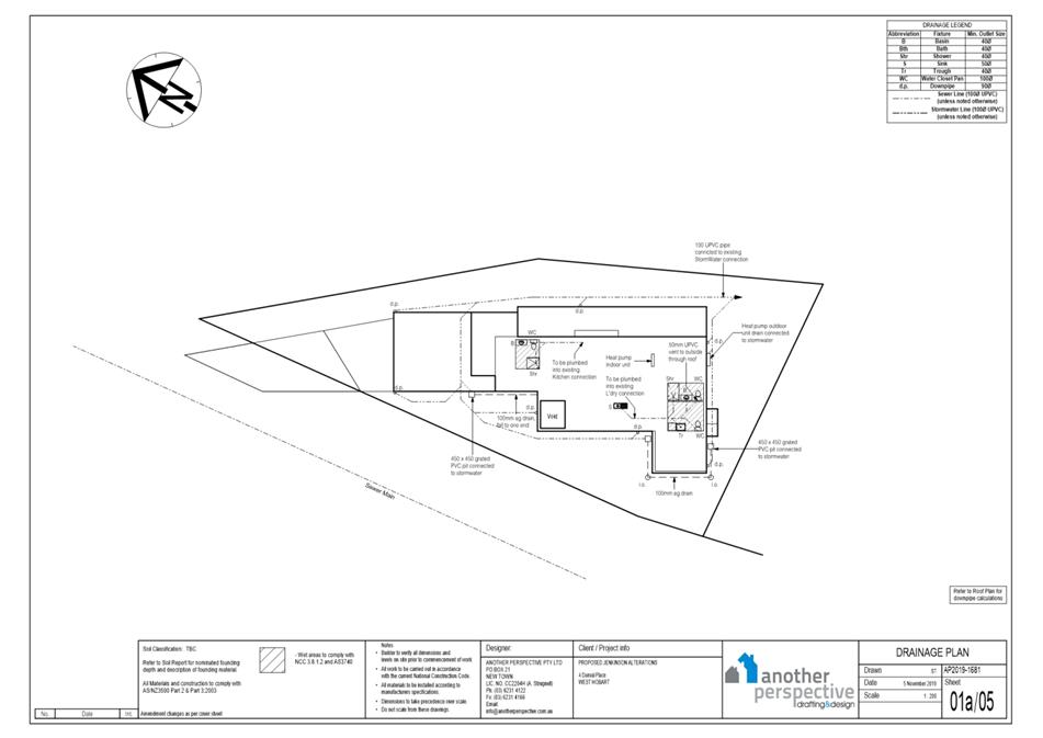
ENG sw1
All stormwater from the proposed development (including but not limited to: roofed areas, ag drains, retaining wall ag drains and impervious surfaces such as driveways and paved areas) must be drained to the Council’s stormwater infrastructure prior to first occupation or commencement of use (whichever occurs first).
Advice: Under section 23 of the Urban Drainage Act 2013 it is an offence for a property owner to direct stormwater onto a neighbouring property.
Reason for condition
To ensure that stormwater from the site will be discharged to a suitable Council approved outlet.
ENG 2a
Prior to first occupation or commencement of use (whichever occurs first), vehicular barriers compliant with the Australian Standard AS/NZS1170.1:2002 must be installed to prevent vehicles running off the edge of an access driveway or parking module (parking spaces, aisles and manoeuvring area) where the drop from the edge of the trafficable area to a lower level is 600mm or greater, and wheel stops (kerb) must be installed for drops between 150mm and 600mm. Barriers must not limit the width of the driveway access or parking and turning areas approved under the permit.
Advice:
The Council
does not consider a slope greater than 1 in 4 to constitute a lower level as
described in AS/NZS 2890.1:2004 Section 2.4.5.3. Slopes greater than 1 in 4
will require a vehicular barrier or wheel stop. Designers are advised to consult the National Construction Code 2016 to determine if pedestrian handrails or safety barriers compliant with the NCC2016 are also required in the parking module this area may be considered as a path of access to a building.
Reason for condition
To ensure the safety of users of the access driveway and parking module and compliance with the standard.
ENG 2b
Prior to the issue of any approval under the Building Act 2016 or the commencement of works on site (whichever occurs first), a certified vehicle barrier design (including site plan with proposed location(s) of installation) prepared by a suitably qualified engineer, compliant with Australian Standard AS/NZS1170.1:2002, must be submitted to Council.
Advice:
If the
development's building approval includes the need for a building permit from
Council, the applicant is advised to submit detailed design of vehicular
barrier as part of the building application. If the development's building approval is covered under Notifiable Work the applicant is advised to submit detailed design of vehicular barrier as a condition endorsement of the planning permit condition. Once the certification has been accepted, the Council will issue a condition endorsement (see general advice on how to obtain condition endorsement).
Reason for condition
To ensure the safety of users of the access driveway and parking module and compliance with the standard.
ENG 2c
Prior to the commencement of use, vehicular barriers must be inspected by a qualified engineer and certification submitted to the Council confirming that the installed vehicular barriers comply with the certified design and Australian Standard AS/NZS1170.1:2002.
Advice: Certification may be submitted to the Council as part of the Building Act 2016 approval process or via condition endorsement (see general advice on how to obtain condition endorsement).
Reason for condition
To ensure the safety of users of the access driveway and parking module and compliance with the relevant standards.
ENG 3a
The access driveway, circulation roadways, ramps and parking module (parking spaces, aisles and manoeuvring area) must be designed and constructed in accordance with Australian Standard AS/NZS2890.1:2004 (including the requirement for vehicle safety barriers where required), or a Council approved alternate design certified by a suitably qualified engineer to provide a safe and efficient access, and enable safe, easy and efficient use.
Advice:
It is advised that designers consider the detailed design of the access and parking module prior to finalising the Finished Floor Level (FFL) of the parking spaces (especially if located within a garage incorporated into the dwelling), as failure to do so may result in difficulty complying with this condition.
Reason for condition
To ensure the safety of users of the access and parking module, and compliance with the relevant Australian Standard.
ENG 3c
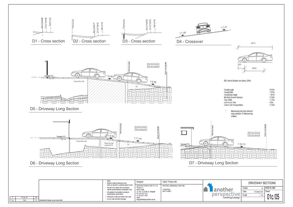
The access driveway and parking module (parking spaces, aisles and manoeuvring area) must be constructed in accordance with the Another Perspective Drafting & Design documentation received by the Council on the 7th January 2020.
Prior to the commencement of use, documentation by a suitably qualified engineer certifying that the access driveway and parking module has been constructed in accordance with the above drawings must be lodged with the Council.
Advice: Certification may be submitted to Council as part of the Building Act 2016 approval process or via condition endorsement (see general advice on how to obtain condition endorsement).
Reason for condition
To ensure the safety of users of the access and parking module, and compliance with the relevant Australian Standard.
ENG 4
The access driveway and parking module (car parking spaces, aisles and manoeuvring area) approved by this permit must be constructed to a sealed standard (spray seal, asphalt, concrete, pavers or equivalent Council approved) and surface drained to the Council's stormwater infrastructure prior to the commencement of use.
Reason for condition
To ensure the safety of users of the access driveway and parking module, and that it does not detract from the amenity of users, adjoining occupiers or the environment by preventing dust, mud and sediment transport.
ENG 5
The number of car parking spaces approved on the site, for use is two (2).
Reason for condition
To ensure the provision of parking for the use is safe and efficient.
ENG 1
Any damage to council infrastructure resulting from the implementation of this permit, must, at the discretion of the Council:
1. Be met by the owner by way of reimbursement (cost of repair and reinstatement to be paid by the owner to the Council); or 2. Be repaired and reinstated by the owner to the satisfaction of the Council.
A photographic record of the Council's infrastructure adjacent to the subject site must be provided to the Council prior to any commencement of works.
A photographic record of the Council’s infrastructure (e.g. existing property service connection points, roads, buildings, stormwater, footpaths, driveway crossovers and nature strips, including if any, pre-existing damage) will be relied upon to establish the extent of damage caused to the Council’s infrastructure during construction. In the event that the owner/developer fails to provide to the Council a photographic record of the Council’s infrastructure, then any damage to the Council's infrastructure found on completion of works will be deemed to be the responsibility of the owner.
Reason for condition
To ensure that any of the Council's infrastructure and/or site-related service connections affected by the proposal will be altered and/or reinstated at the owner’s full cost.
ENG r1
The footings (driveway deck) within the highway reservation must not undermine the stability and integrity of the highway reservation and its infrastructure.
Detailed design drawings and structural certificates of the driveway deck footings within the Danval Place highway reservation must be submitted and approved, prior to the commencement of work and must:
1. Be prepared and certified by a suitable qualified person and experienced engineer; 2. Not undermine the stability of the highway reservation; 3. Take into account any additional surcharge loadings as required by relevant Australian Standards; 4. Take into account and reference accordingly any Geotechnical findings; 5. Detail the design and location of the footing adjacent to Danval Place highway reservation; and 6. Include a structure certificate which notes that the driveway deck footings will not undermine the highway reservation.
All work required by this condition must be undertaken in accordance with the approved select design drawing and structural certificates.
Advice: The applicant
is required submit detailed design documentation to satisfy this condition
via Council's planning condition endorsement process (noting there is a fee
associated with condition endorsement approval of engineering drawings [see
general advice on how to obtain condition endorsement and for fees and
charges]). Failure to address condition endorsement requirements prior to submitting for building approval may result in unexpected delays.
Reason for condition
To ensure that the stability and integrity of the Council’s highway reservation is not compromised by the development.
ENGR 3
Prior to the commencement of use, the proposed driveway crossover Danval Place highway reservation must be designed and constructed in accordance with engineering design plans submitted and approved by the City of Hobart's Road Services Engineer.
Design drawings must be submitted and approved prior to the commencement of work. The design drawing must:
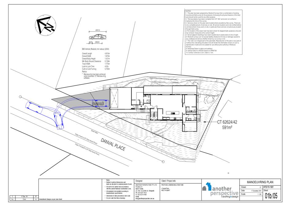
1. Show the cross and long sections (centreline and both edges) of the driveway crossover within the highway reservation and onto the property 2. Detail any services or infrastructure (i.e. light poles, pits, awnings) at or near the proposed driveway crossover 3. Reinstatement of the redundant vehicle crossing to kerb 4. Show swept path templates in accordance with AS/NZS 2890.1 2004 5. Demonstrate that a B85 vehicle or B99 depending on use (AS/NZS 2890.1 2004, section 2.6.2) can access the driveway from the road pavement into the property without scraping the cars underside 6. Be prepared and certified by a suitable qualified person, to satisfy the above requirement.
All work required by this condition must be undertaken in accordance with the approved drawings.
Advice:
The applicant
is required submit detailed design documentation to satisfy this condition
via Council's planning condition endorsement process (noting there is a fee
associated with condition endorsement approval of engineering drawings [see
general advice on how to obtain condition endorsement and for fees and
charges]). This is a separate process to any building approval under the Building Act 2016. A Permit to
Carry out Works within the highway reservation is required prior to commencement
of work within the highway. Please note that your proposal does not include adjustment of footpath levels. Any adjustment to footpath levels necessary to suit the design of proposed floor, parking module or driveway levels will require separate agreement from Council's Road Services Engineer and may require further planning approvals. It is advised to place a note to this affect on construction drawings for the site and/or other relevant engineering drawings to ensure that contractors are made aware of this requirement. Failure to address condition endorsement requirements prior to submitting for building approval may result in unexpected delays.
Reason for condition
To ensure that works will comply with the Council’s standard requirements.
ENV 1
Sediment and erosion control measures sufficient to prevent sediment from leaving the site must be installed prior to any disturbance of the site, and maintained until all areas of disturbance have been stabilized or re-vegetated.
Advice:
Reason for condition
To avoid the sedimentation of roads, drains, natural watercourses, Council land that could be caused by erosion and runoff from the development, and to comply with relevant State legislation.
ADVICE
The following advice is provided to you to assist in the implementation of the planning permit that has been issued subject to the conditions above. The advice is not exhaustive and you must inform yourself of any other legislation, by-laws, regulations, codes or standards that will apply to your development under which you may need to obtain an approval. Visit the Council's website for further information.
Prior to any commencement of work on the site or commencement of use the following additional permits/approval may be required from the Hobart City Council.
CONDITION ENDORSEMENT ENGINEERING
All engineering drawings required to be submitted and approved by this planning permit must be submitted to the City of Hobart as a CEP (Condition Endorsement) via the City’s Online Service Development Portal. When lodging a CEP, please reference the PLN number of the associated Planning Application. Each CEP must also include an estimation of the cost of works shown on the submitted engineering drawings. Once that estimation has been confirmed by the City’s Engineer, the following fees are payable for each CEP submitted and must be paid prior to the City of Hobart commencing assessment of the engineering drawings in each CEP:
Value of Building Works Approved by Planning Permit Fee: Up to $20,000: $150 per application. Over $20,000: 2% of the value of the works as assessed by the City's Engineer per assessment.
These fees are additional to building and plumbing fees charged under the Building and Plumbing Regulations.
Once the CEP is lodged via the Online Service Development Portal, if the value of building works approved by your planning permit is over $20,000, please contact the City’s Development Engineer on 6238 2715 to confirm the estimation of the cost of works shown on the submitted engineering drawings has been accepted.
Once confirmed, pleased call one of the City’s Customer Service Officers on 6238 2190 to make payment, quoting the reference number (i.e. CEP number) of the Condition Endorsement you have lodged. Once payment is made, your engineering drawings will be assessed.
BUILDING PERMIT
You may need building approval in accordance with the Building Act 2016. Click here for more information.
This is a Discretionary Planning Permit issued in accordance with section 57 of the Land Use Planning and Approvals Act 1993.
PLUMBING PERMIT
You may need plumbing approval in accordance with the Building Act 2016, Building Regulations 2016 and the National Construction Code. Click here for more information.
OCCUPATION OF THE PUBLIC HIGHWAY
You may require a permit for the occupation of the public highway for construction (e.g. placement of skip bin, crane, scissor lift etc.). Click here for more information.
You may require a road closure permit for construction. Click here for more information.
You may require a Permit to Open Up and Temporarily Occupy a Highway (for work in the road reserve). Click here for more information.
PLANNING
You are encouraged to plant and maintain screening vegetation above the height of the existing paling fence between the existing dwelling and the rear boundaries with 10 Shannuk Drive and 9 Rennie Street. This vegetation would improve privacy and reduce overlooking between the deck and the neighbouring private outdoor space.
STORMWATER
Please note that in addition to a building and/or plumbing permit, development must be in accordance with the Hobart City Council’s Infrastructure By law. Click here for more information.
WORK WITHIN THE HIGHWAY RESERVATION
Please note development must be in accordance with the Hobart City Council’s Infrastructure By law. Click here for more information.
DRIVEWAY SURFACING OVER HIGHWAY RESERVATION
If a coloured or textured surface is used for the driveway access within the Highway Reservation, the Council or other service provider will not match this on any reinstatement of the driveway access within the Highway Reservation required in the future.
REDUNDANT CROSSOVERS
Redundant crossovers are required to be reinstated under the Hobart City Council’s Infrastructure By law. Click here for more information.
ACCESS
Designed in accordance with LGAT- IPWEA – Tasmanian standard drawings. Click here for more information.
CROSS OVER CONSTRUCTION
The construction of the crossover can be undertaken by the Council or by a private contractor, subject to Council approval of the design. Click here for more information.
WORK PLACE HEALTH AND SAFETY
Appropriate occupational health and safety measures must be employed during the works to minimise direct human exposure to potentially-contaminated soil, water, dust and vapours. Click here for more information.
NOISE REGULATIONS
Click here for information with respect to noise nuisances in residential areas.
WASTE DISPOSAL
It is recommended that the developer liaise with the Council’s Cleansing and Solid Waste Unit regarding reducing, reusing and recycling materials associated with demolition on the site to minimise solid waste being directed to landfill.
Further information regarding waste disposal can also be found on the Council’s website.
FEES AND CHARGES
Click here for information on the Council's fees and charges.
DIAL BEFORE YOU DIG
Click here for dial before you dig information
|
As signatory to this report, I certify that, pursuant to Section 55(1) of the Local Government Act 1993, I hold no interest, as referred to in Section 49 of the Local Government Act 1993, in matters contained in this report.
|
Karen Abey Manager Development Appraisal |
|
Date: 11 March 2020
File Reference: F20/26960; PLN-19-818
Attachment a: Attachment
A - Approved Plans for PLN-19-120 ⇩ ![]()
Attachment
b: Attachment
B - PLN-19-818 - 4 DANVAL PLACE WEST HOBART - Planning Report and Agenda
Documents ⇩ ![]()
Attachment
c: Attachment
C - Plan demonstrating compliance with clause 10.4.2 A2(c) ⇩ ![]()
|
Item No. 7.2.2 |
Agenda (Open Portion) City Planning Committee Meeting - 16/3/2020 |
Page 121 ATTACHMENT a |
|
Agenda (Open Portion) City Planning Committee Meeting - 16/3/2020 |
Page 189 ATTACHMENT b |
|
Agenda (Open Portion) City Planning Committee Meeting - 16/3/2020 |
Page 215 ATTACHMENT c |
|
Item No. 7.2.3 |
Agenda (Open Portion) City Planning Committee Meeting |
Page 216 |
|
|
16/3/2020 |
|
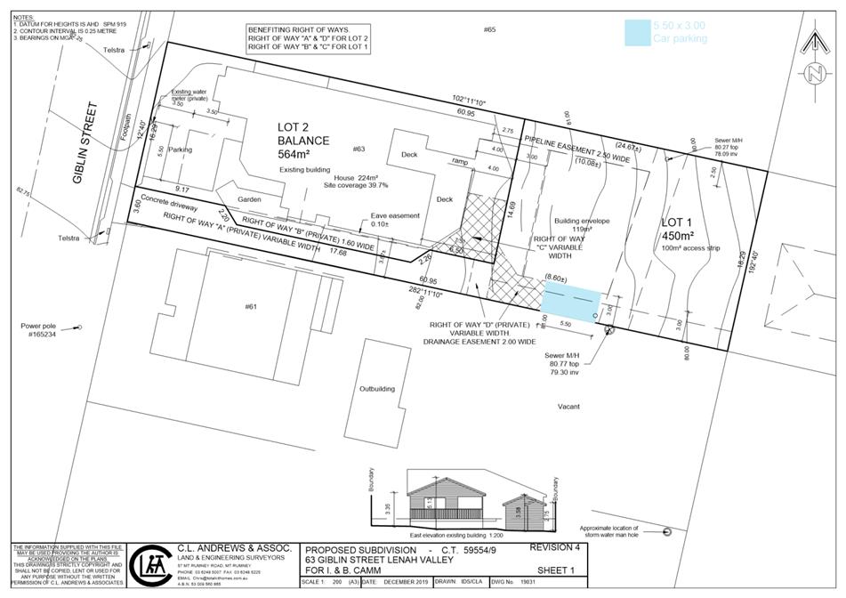
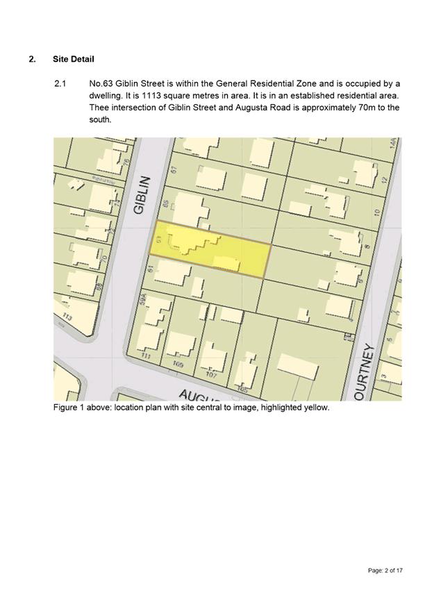
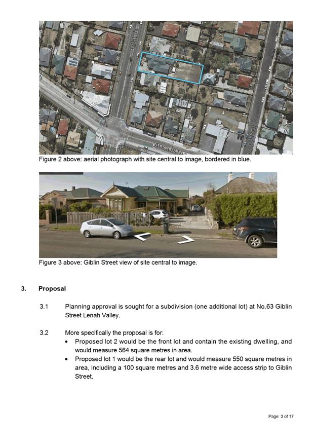
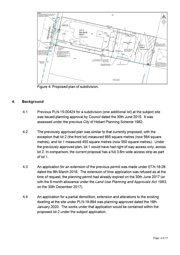
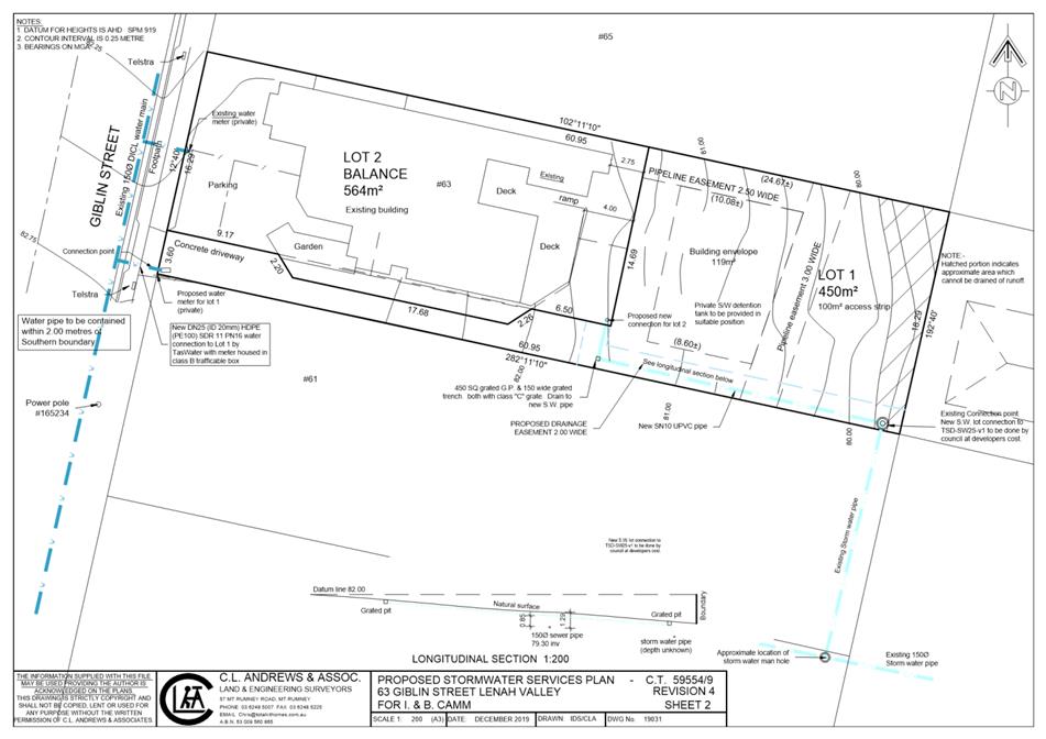
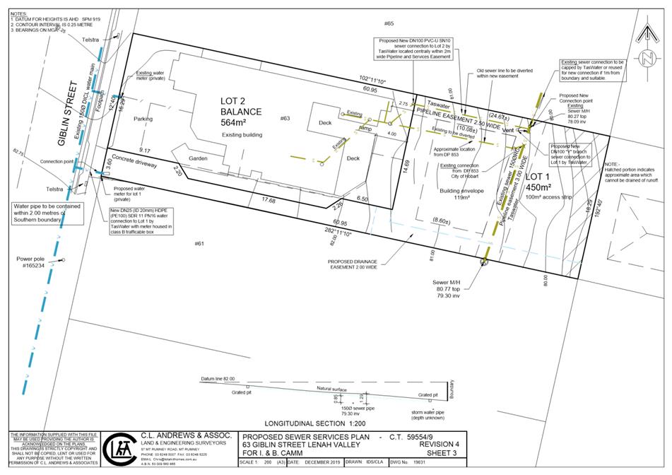
7.2.3 63 Giblin Street, Lenah Valley - Subdivision (One Additional Lot)
Address: 63 Giblin Street, Lenah Valley
Proposal: Subdivision (One Additional Lot)
Expiry Date: 14 April 2020
Extension of Time: Not applicable
Author: Richard Bacon
|
REcommendation That pursuant to the Hobart Interim Planning Scheme 2015, the Council refuse the application for a subdivision (one additional lot) at 63 Giblin Street Lenah Valley TAS 7008 for the following reasons:
1. The proposal does not meet the acceptable solution or the performance criterion with respect to clause 10.6.1 A1 and P1 of the Hobart Interim Planning Scheme 2015 because the subdivision includes a proposed Lot 1 which does not achieve the minimum lot size required for an internal lot under Table 10.1.
|
Attachment a: PLN-19-454
- 63 GIBLIN STREET LENAH VALLEY TAS 7008 - Planning Committee or Delegated
Report ⇩ ![]()
Attachment
b: PLN-19-454-
63 GIBLIN STREET LENAH VALLEY TAS 7008 - CPC Agenda Documents ⇩ ![]()
|
Item No. 7.2.3 |
Agenda (Open Portion) City Planning Committee Meeting - 16/3/2020 |
Page 233 ATTACHMENT a |
|
Agenda (Open Portion) City Planning Committee Meeting - 16/3/2020 |
Page 236 ATTACHMENT b |
|
Agenda (Open Portion) City Planning Committee Meeting |
Page 249 |
|
|
|
16/3/2020 |
|
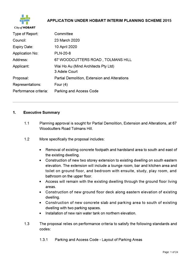
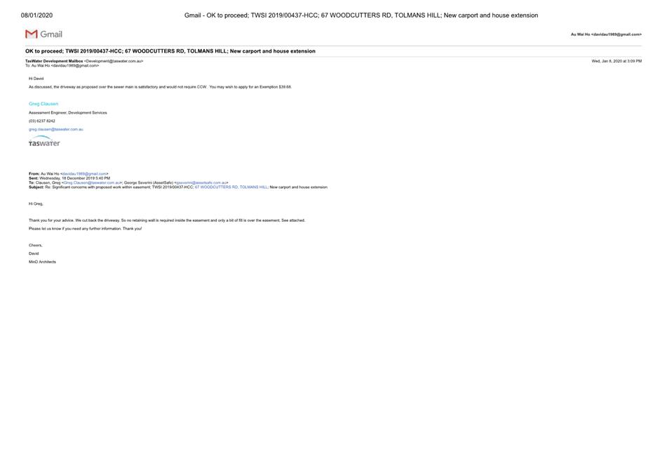
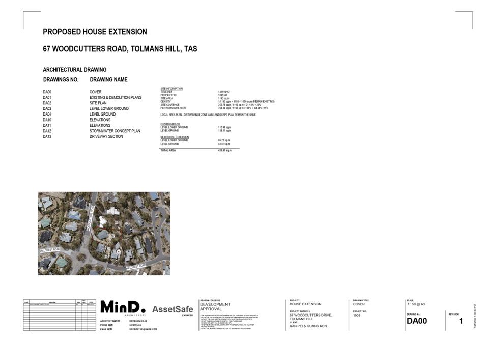
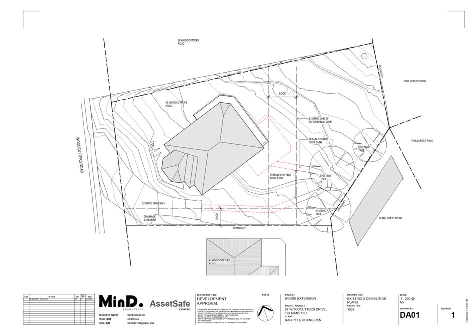
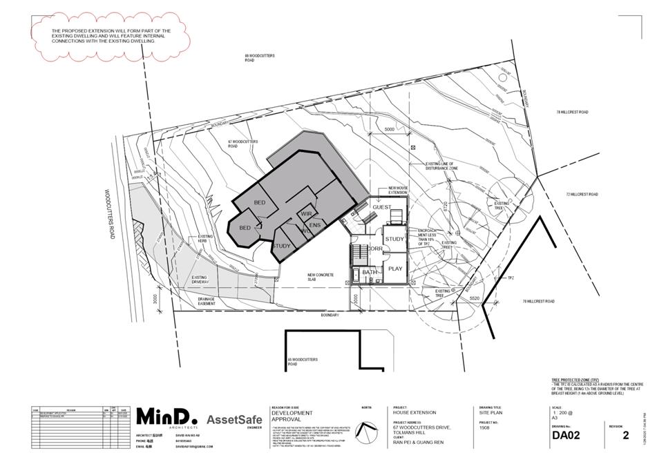
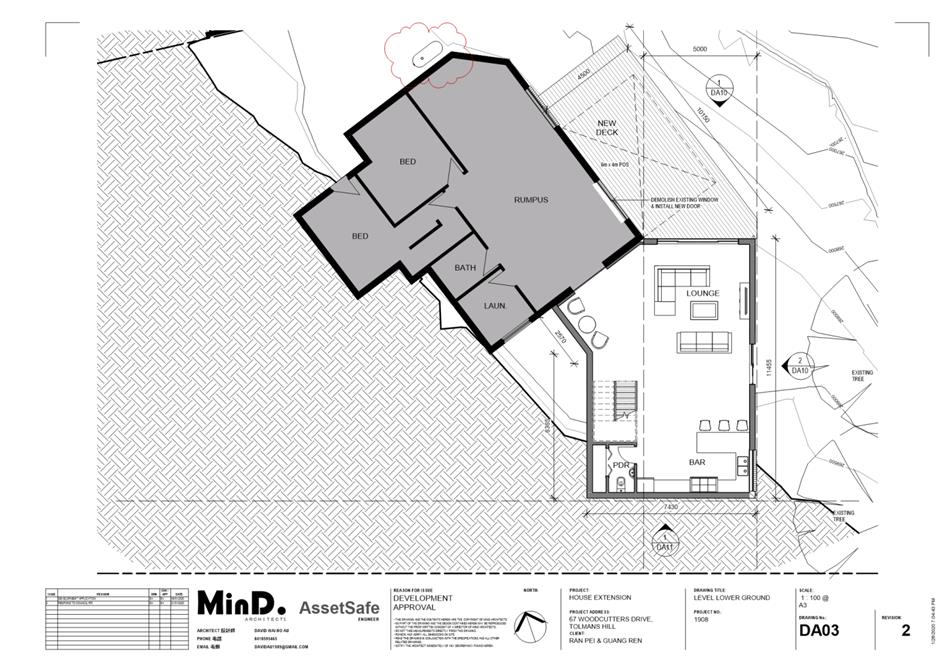
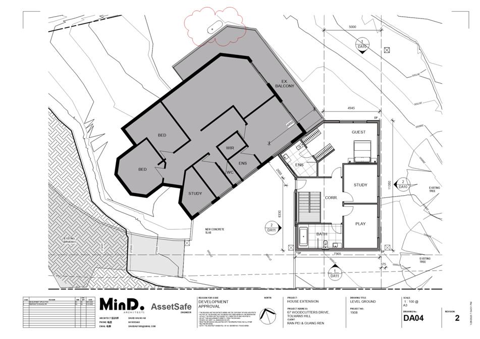
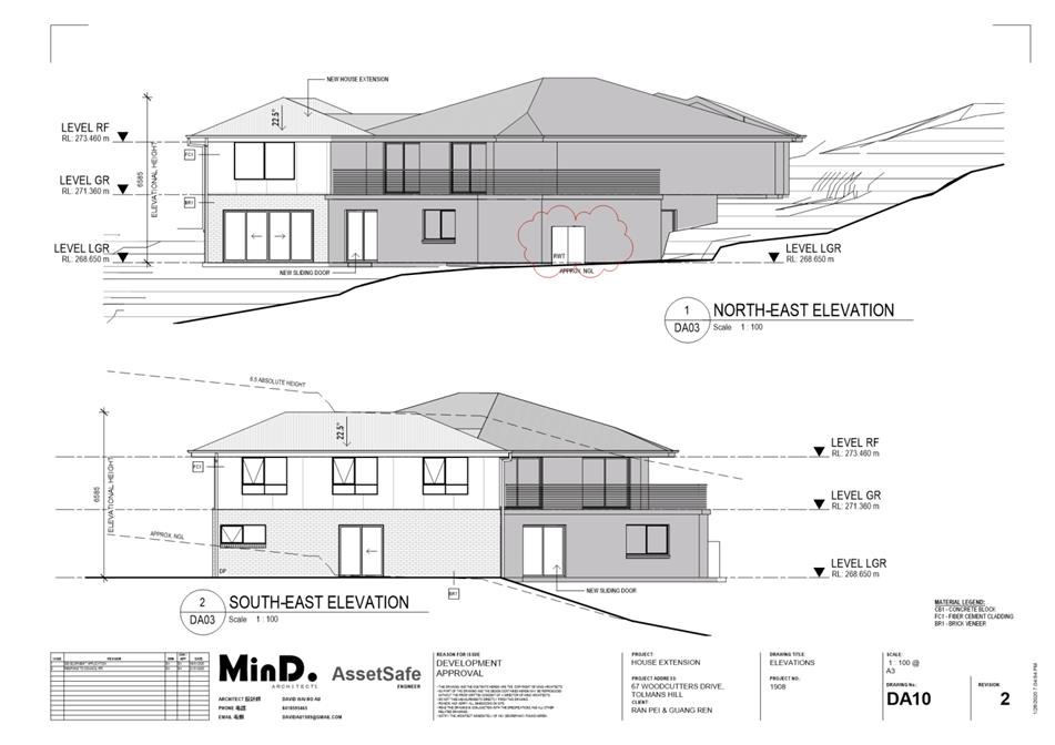
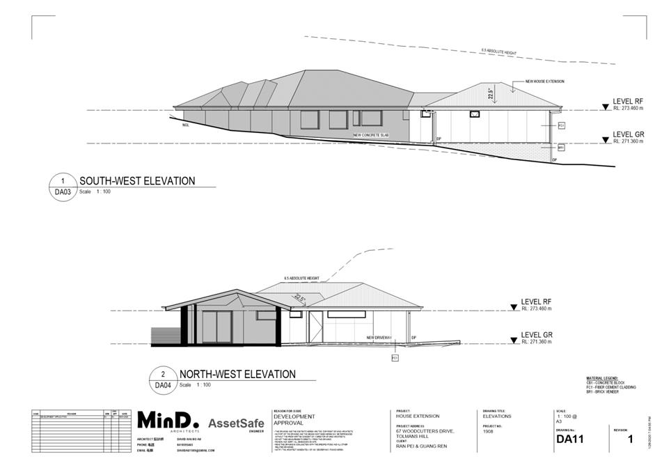
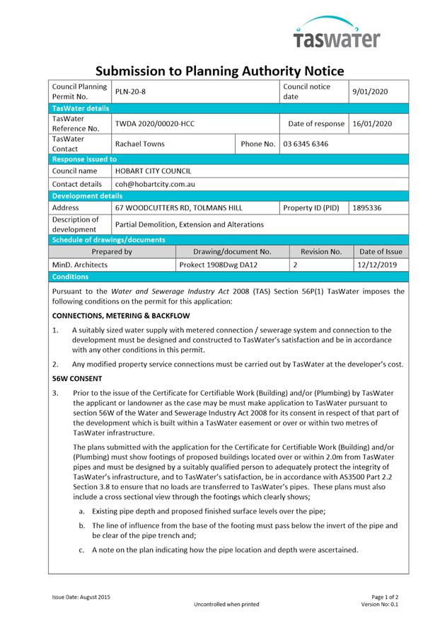
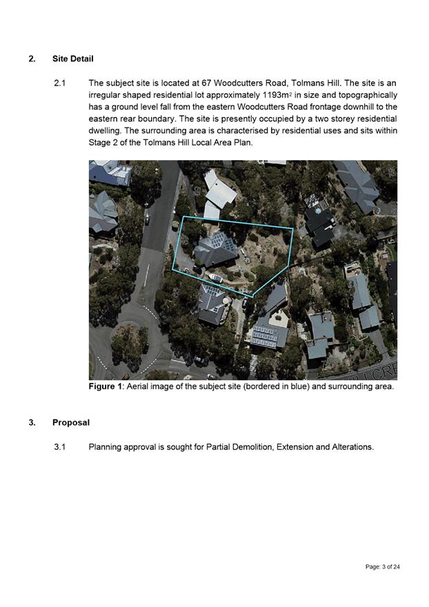
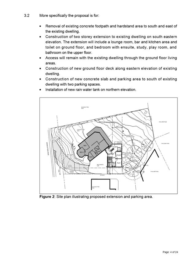
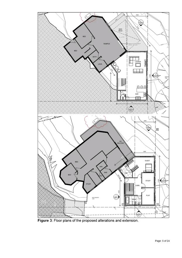
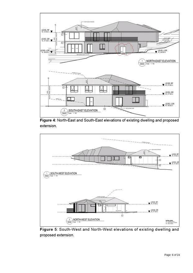
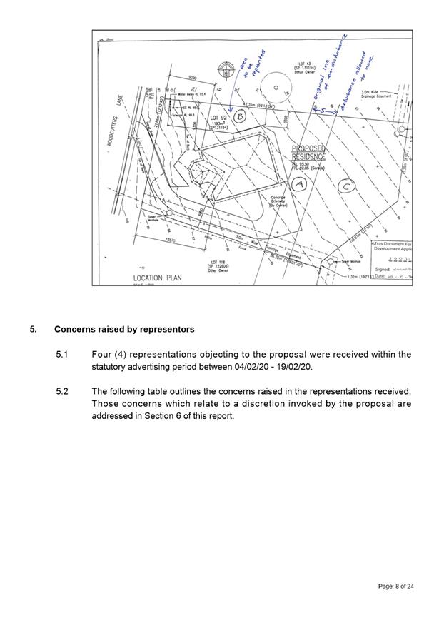
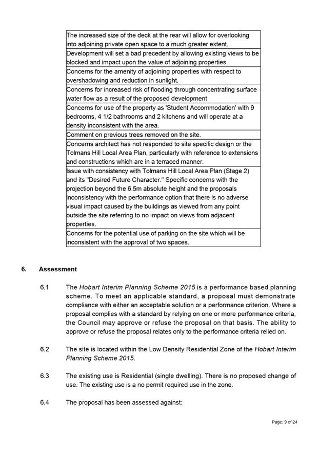
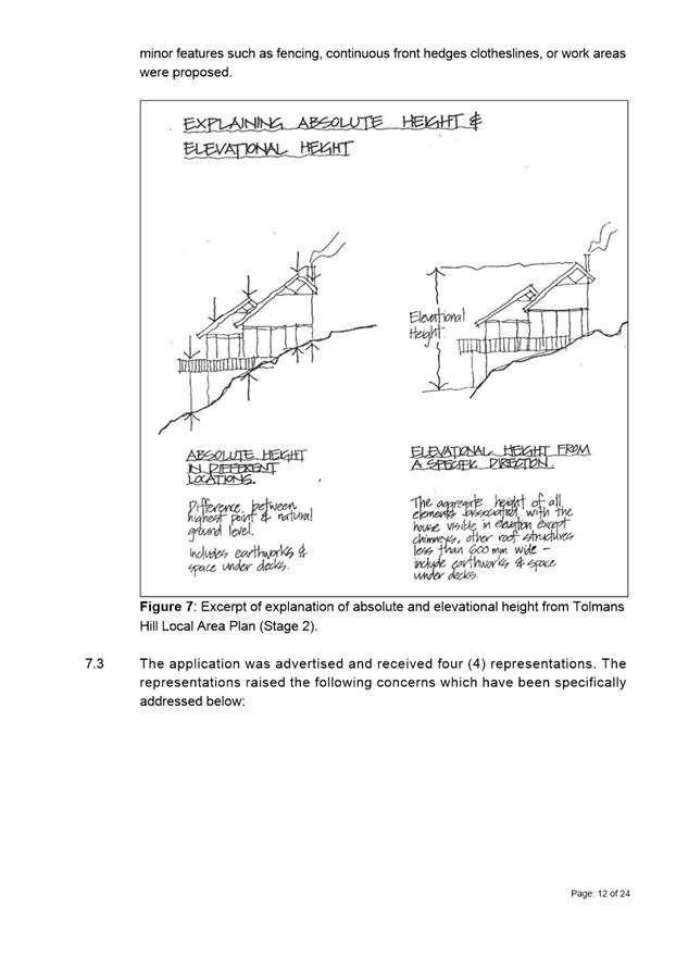
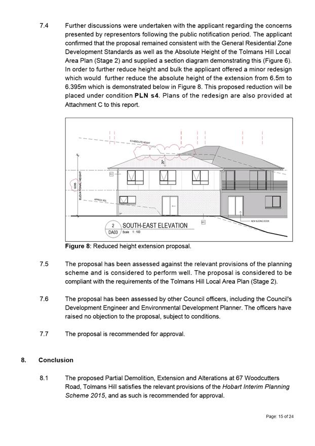
7.2.4 67 Woodcutters Road, Tolmans Hill - Partial Demolition, Extension and Alterations
Address: 67 Woodcutters Road, Tolmans Hill
Proposal: Partial Demolition, Extension and Alterations
Expiry Date: 10 April 2020
Extension of Time: Not applicable
Author: Michael McClenahan
|
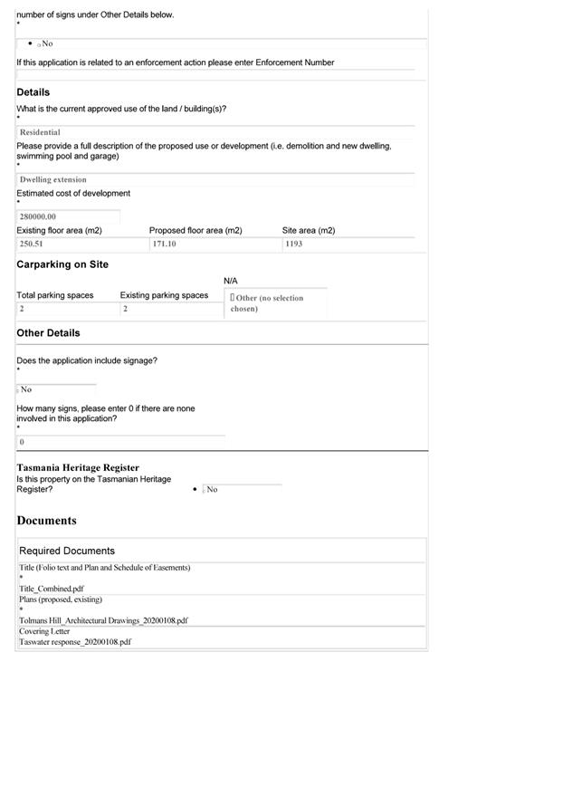
REcommendation That pursuant to the Hobart Interim Planning Scheme 2015, the Council approve the application for partial demolition, extension and alterations at 67 Woodcutters Road, Tolmans Hill for the reasons outlined in the officer’s report and a permit containing the following conditions be issued:
GEN
The use and/or development must be substantially in accordance with the documents and drawings that comprise PLN208 67 WOODCUTTERS ROAD TOLMANS HILL TAS 7007 Final Planning Documents except where modified below.
Reason for condition
To clarify the scope of the permit.
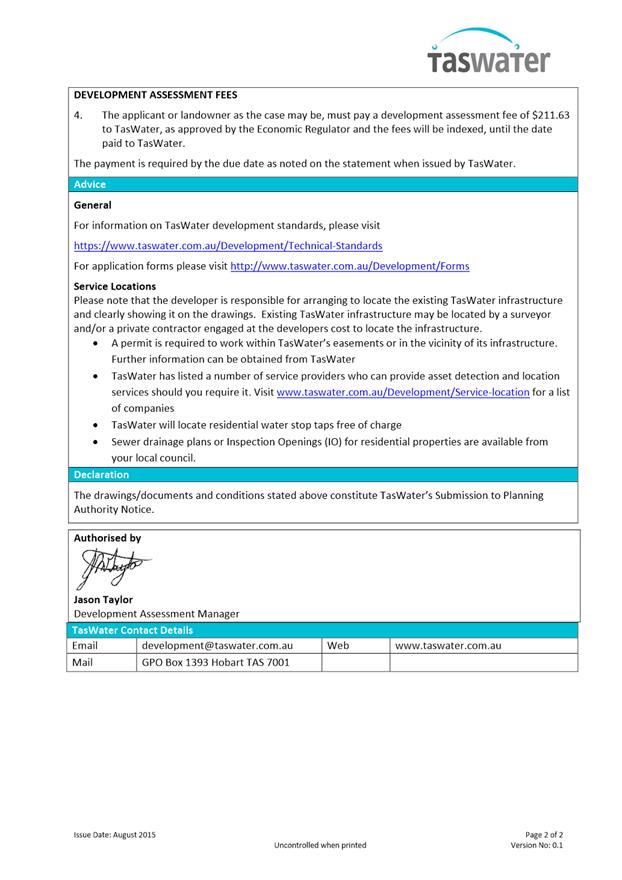
TW
The use and/or development must comply with the requirements of TasWater as detailed in the form Submission to Planning Authority Notice, Reference No. TWDA 2020/00020HCC dated 16/01/2020 as attached to the permit.
Reason for condition
To clarify the scope of the permit.
PLN s1
This permit does not approve a change of use to the existing single dwelling on the site. The use must remain as a single dwelling unless further and separate planning approval is sought and obtained from the Council.
Reason for condition
To clarify the scope of the permit
PLN s4
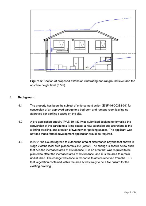
Prior to the issue of any approval/consent under the Building Act 2016, or commencement of work on site (whichever occurs first), revised plans must be submitted and approved showing:
1. The extension to the existing dwelling with an absolute height not exceeding 6.395m above natural ground level at any point.
All work required by this condition must be undertaken in accordance with the approved revised plans.
Advice:
The plans submitted informally to Council on 23 February 2020 (drawing DA10 Rev. 3 and DA 11 Rev 2, both dated 21/2/2020) are considered to satisfy this condition.
Reason for condition
To clarify the scope of the permit
ENG sw1
All stormwater from the proposed development (including but not limited to: roofed areas, ag drains, retaining wall ag drains and impervious surfaces such as driveways and paved areas) must be drained to the Council’s stormwater infrastructure prior to first occupation or commencement of use (whichever occurs first).
Advice:
Under section 23 of the Urban Drainage Act 2013 it is an offence for a property owner to direct stormwater onto a neighbouring property.
Reason for condition
To ensure that stormwater from the site will be discharged to a suitable Council approved outlet.
ENG sw8
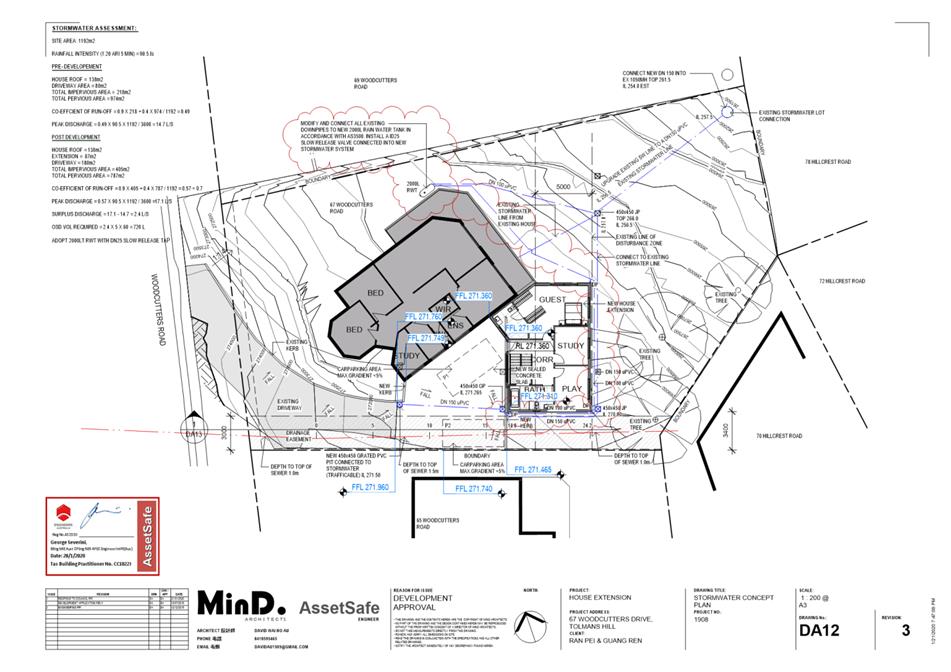
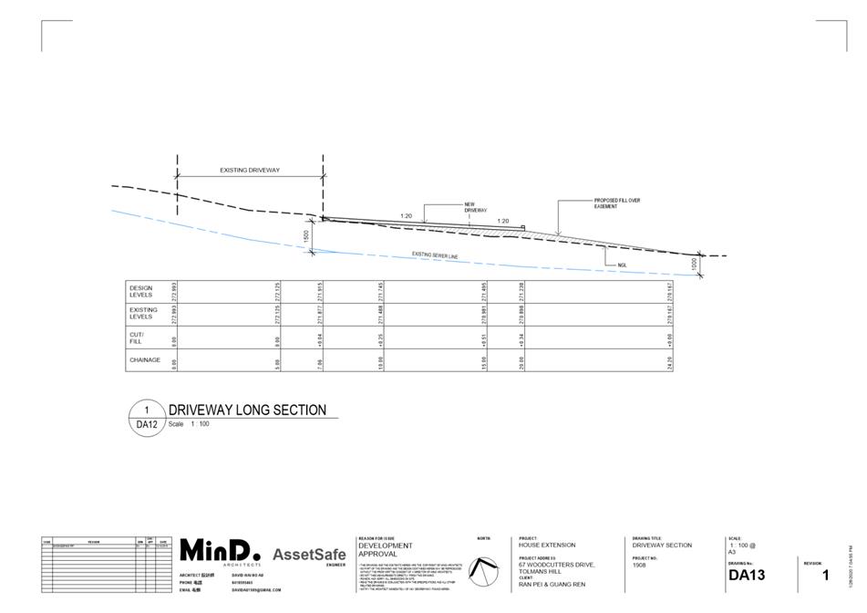
Prior to first occupation, a stormwater detention system in accordance MinD Architects drawing DA12 Revision 3 must be installed to limit stormwater discharges from the roofed area on the site to a maximum of 2.5 L/s.
Reason for condition
To ensure that the stormwater runoff quantity is managed to take into account the limited receiving capacity of the downstream Council stormwater infrastructure.
ENG 2a
Prior to first occupation or commencement of use (whichever occurs first), vehicular barriers compliant with the Australian Standard AS/NZS1170.1:2002 must be installed to prevent vehicles running off the edge of an access driveway or parking module (parking spaces, aisles and manoeuvring area) where the drop from the edge of the trafficable area to a lower level is 600mm or greater, and wheel stops (kerb) must be installed for drops between 150mm and 600mm. Barriers must not limit the width of the driveway access or parking and turning areas approved under the permit.
Advice:
The Council does not consider a slope greater than 1 in 4 to constitute a lower level as described in AS/NZS 2890.1:2004 Section 2.4.5.3. Slopes greater than 1 in 4 will require a vehicular barrier or wheel stop.
Designers are advised to consult the National Construction Code 2016 to determine if pedestrian handrails or safety barriers compliant with the NCC2016 are also required in the parking module this area may be considered as a path of access to a building.
Reason for condition
To ensure the safety of users of the access driveway and parking module and compliance with the standard.
ENG 2b
Prior to the issue of any approval under the Building Act 2016 or the commencement of works on site (whichever occurs first), a certified vehicle barrier design (including site plan with proposed location(s) of installation) prepared by a suitably qualified engineer, compliant with Australian Standard AS/NZS1170.1:2002, must be submitted to Council.
Advice:
If the development's building approval includes the need for a Building Permit from Council, the applicant is advised to submit detailed design of vehicular barrier as part of the Building Application.
If the development's building approval is covered under Notifiable Work the applicant is advised to submit detailed design of vehicular barrier as a condition endorsement of the planning permit condition. Once the certification has been accepted, the Council will issue a condition endorsement (see general advice on how to obtain condition endorsement).
Reason for condition
To ensure the safety of users of the access driveway and parking module and compliance with the standard.
ENG 2c
Prior to the commencement of use, vehicular barriers must be inspected by a qualified engineer and certification submitted to the Council confirming that the installed vehicular barriers comply with the certified design and Australian Standard AS/NZS1170.1:2002.
Advice:
Certification may be submitted to the Council as part of the Building Act 2016 approval process or via condition endorsement (see general advice on how to obtain condition endorsement).
Reason for condition
To ensure the safety of users of the access driveway and parking module and compliance with the relevant standards.
ENG 3a
The driveway and parking module (parking spaces, aisles and manoeuvring area) must be designed and constructed in accordance with Australian Standard AS/NZS2890.1:2004 (including the requirement for vehicle safety barriers where required) with the exception that jockey parking is permitted.
Advice:
It is advised that designers consider the detailed design of the access and parking module prior to finalising the Finished Floor Level (FFL) of the parking spaces (especially if located within a garage incorporated into the dwelling), as failure to do so may result in difficulty complying with this condition.
Reason for condition
To ensure the safety of users of the access and parking module, and compliance with the relevant Australian Standard.
ENG 4
The driveway and parking module (car parking spaces, aisles and manoeuvring area) approved by this permit must be constructed to a sealed standard (spray seal, asphalt, concrete, pavers or equivalent Council approved) and surface drained to the Council's stormwater infrastructure prior to the commencement of use.
Reason for condition
To ensure the safety of users of the access driveway and parking module, and that it does not detract from the amenity of users, adjoining occupiers or the environment by preventing dust, mud and sediment transport.
ENG 5
The number of car parking spaces approved on the site is two (2).
Reason for condition
To ensure the provision of parking for the use is safe and efficient.
ENG 1
Any damage to council infrastructure resulting from the implementation of this permit, must, at the discretion of the Council:
1. Be met by the owner by way of reimbursement (cost of repair and reinstatement to be paid by the owner to the Council); or 2. Be repaired and reinstated by the owner to the satisfaction of the Council.
A photographic record of the Council's infrastructure adjacent to the subject site must be provided to the Council prior to any commencement of works.
A photographic record of the Council’s infrastructure (e.g. existing property service connection points, roads, buildings, stormwater, footpaths, driveway crossovers and nature strips, including if any, preexisting damage) will be relied upon to establish the extent of damage caused to the Council’s infrastructure during construction. In the event that the owner/developer fails to provide to the Council a photographic record of the Council’s infrastructure, then any damage to the Council's infrastructure found on completion of works will be deemed to be the responsibility of the owner.
Reason for condition
To ensure that any of the Council's infrastructure and/or siterelated service connections affected by the proposal will be altered and/or reinstated at the owner’s full cost.
ADVICE
The following advice is provided to you to assist in the implementation of the planning permit that has been issued subject to the conditions above. The advice is not exhaustive and you must inform yourself of any other legislation, bylaws, regulations, codes or standards that will apply to your development under which you may need to obtain an approval. Visit the Council's website for further information.
Prior to any commencement of work on the site or commencement of use the following additional permits/approval may be required from the Hobart City Council.
BUILDING PERMIT
You may need building approval in accordance with the Building Act 2016. Click here for more information.
This is a Discretionary Planning Permit issued in accordance with section 57 of the Land Use Planning and Approvals Act 1993.
PLUMBING PERMIT
You may need plumbing approval in accordance with the Building Act 2016, Building Regulations 2016 and the National Construction Code. Click here for more information.
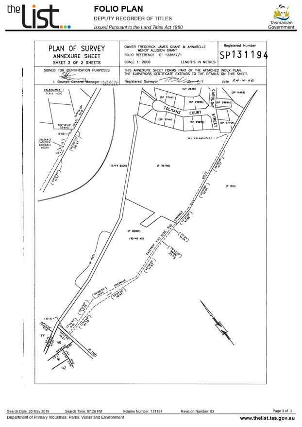
TOLMANS HILL LOCAL AREA PLAN
The Tolmans Hill Local Area Plan (Stage 2) is available here.
Front fences must not be erected on the property, and side boundary fences must be in accordance with the provisions of the Tolmans Hill Local Area Plan (Stage 2).
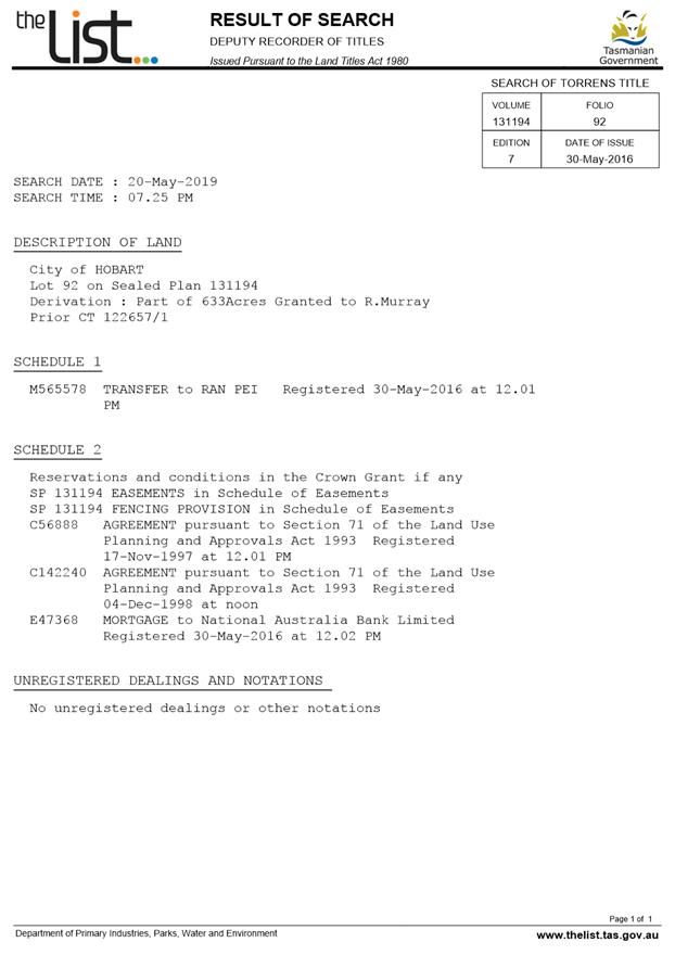
This approval and subsequent conditions are given in the knowledge that the Part 5 Agreement on the title (CT. 131194/92) to the property is effective and binds the applicant to the restrictions and controls of the Tolmans Hill Local Area Plan (Stage 2).
Plant species listed in Council’s Restricted Plant List: Potentially Invasive Species Generally Unsuitable for Planting in or Adjacent Bushland, Riparian and Coastal Areas (June 2011) must not be planted on the lot (available here).
WEED CONTROL
Effective measures are detailed in the Tasmanian Washdown Guidelines for Weed and Disease Control: Machinery, Vehicles and Equipment (Edition 1, 2004). The guidelines can be obtained from the Department of Primary Industries, Parks, Water and Environment website.
WORK PLACE HEALTH AND SAFETY
Appropriate occupational health and safety measures must be employed during the works to minimise direct human exposure to potentiallycontaminated soil, water, dust and vapours. Click here for more information.
NOISE REGULATIONS
Click here for information with respect to noise nuisances in residential areas.
WASTE DISPOSAL
It is recommended that the developer liaise with the Council’s Cleansing and Solid Waste Unit regarding reducing, reusing and recycling materials associated with demolition on the site to minimise solid waste being directed to landfill.
Further information regarding waste disposal can also be found on the Council’s website.
FEES AND CHARGES
Click here for information on the Council's fees and charges.
DIAL BEFORE YOU DIG
Click here for dial before you dig information.
|
Attachment a: PLN-20-8
- 67 WOODCUTTERS ROAD TOLMANS HILL TAS 7007 - Planning Committee or Delegated
Report ⇩ ![]()
Attachment
b: PLN-20-8
- 67 WOODCUTTERS ROAD TOLMANS HILL TAS 7007 - CPC Agenda Documents ⇩ ![]()
Attachment
c: PLN-20-8
- 67 WOODCUTTERS ROAD TOLMANS HILL TAS 7007 - CPC Supporting Documents
(Supporting information) ![]()
|
Item No. 7.2.4 |
Agenda (Open Portion) City Planning Committee Meeting - 16/3/2020 |
Page 273 ATTACHMENT a |

|
Agenda (Open Portion) City Planning Committee Meeting - 16/3/2020 |
Page 283 ATTACHMENT b |
|
Agenda (Open Portion) City Planning Committee Meeting |
Page 300 |
|
|
|
16/3/2020 |
|
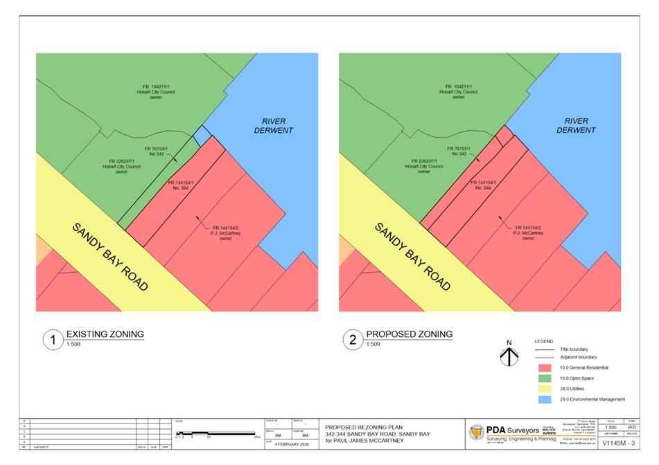
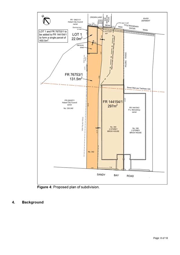
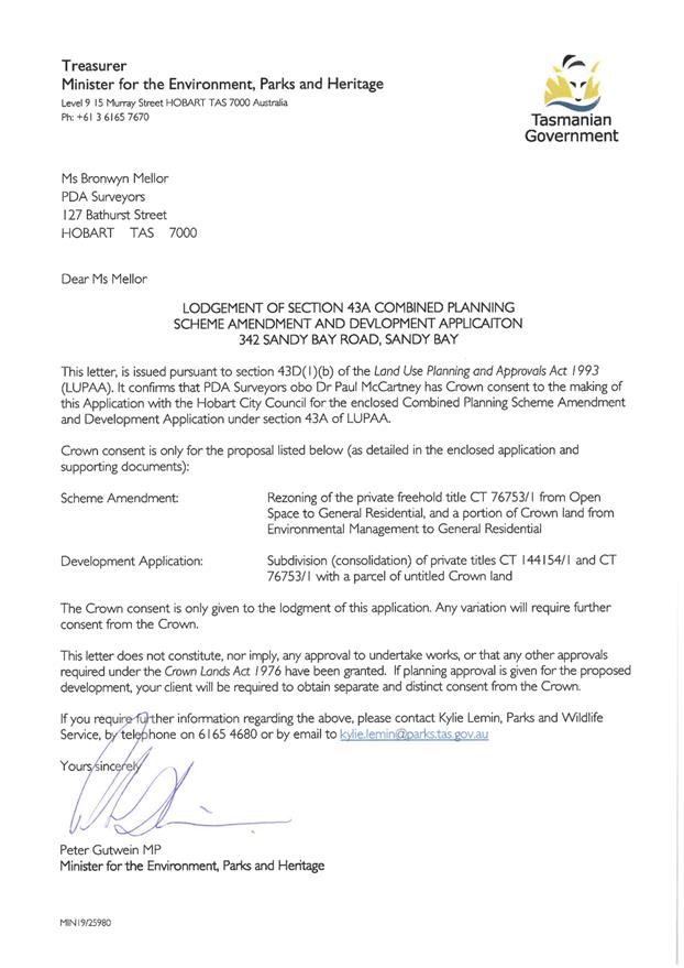
7.2.5 342 Sandy Bay Road, Sandy Bay 1/ 344-346 Sandy Bay Road, Sandy Bay Adjacent Crown Land
Address: 342 Sandy Bay Road, Sandy Bay, 1/344-346 Sandy Bay Road, Sandy Bay Adjacent Crown Land`
Proposal: Subdivision (Lot Consolidation)
Expiry Date: 14 April 2020
Extension of Time: Not applicable
Author: Michael McClenahan
|
REcommendation That pursuant to the Hobart Interim Planning Scheme 2015, the Council approve the application for subdivision (lot consolidation) at 342 and 1/344346 Sandy Bay Road, Sandy Bay and adjacent crown land for the reasons outlined in the officer’s report and a permit containing the following conditions be issued:
GEN
The use and/or development must be substantially in accordance with the documents and drawings that comprise PLN20146 342 SANDY BAY ROAD SANDY BAY TAS 7005 Final Planning Documents except where modified below.
Reason for condition
To clarify the scope of the permit.
SUB s1
An amendment to Strata Plan 144514 must be submitted to Council in accordance with the requirements of sections 19 and 31 of the Strata Titles Act 1998, once the Planning Scheme Amendment to rezone Lot 1 and the land comprised in CT 76753/1 to General Residential has been approved.
Reason for condition
To enable Lot 1 and CT 76753/1 to be added to CT 144154/1 and the common property for Strata Plan 144514
ADVICE
The following advice is provided to you to assist in the implementation of the planning permit that has been issued subject to the conditions above. The advice is not exhaustive and you must inform yourself of any other legislation, bylaws, regulations, codes or standards that will apply to your development under which you may need to obtain an approval. Visit the Council's website for further information.
Prior to any commencement of work on the site or commencement of use the following additional permits/approval may be required from the Hobart City Council.
PLUMBING PERMIT
You may need plumbing approval in accordance with the Building Act 2016, Building Regulations 2016 and the National Construction Code. Click here for more information.
STORMWATER
Please note that in addition to a building and/or plumbing permit, development must be in accordance with the Hobart City Council’s Infrastructure By law. Click here for more information.
COUNCIL RESERVES
This permit does not authorise any works on the adjoining Council land. Any act that causes, or is likely to cause, damage to Council’s land may be in breach of Council’s Public Spaces Bylaw and penalties may apply. A permit is required for works on Council land. The bylaw is available here.
FEES AND CHARGES
Click here for information on the Council's fees and charges.
SUBDIVISION ADVICE
For information regarding standards and guidelines for subdivision works click here. All conditions imposed by this permit are in accordance with the Local Government Building & Miscellaneous Provisions) Act 1993 and the Conveyancing and Law of Property Act 1884.
|
Attachment
a: PLN-20-146
- 342 SANDY BAY ROAD SANDY BAY TAS 7005 - Planning Committee or Delegated
Report ⇩ ![]()
Attachment
b: PLN-20-146
- 342 SANDY BAY ROAD SANDY BAY TAS 7005 - CPC Agenda Documents ⇩ ![]()
|
Item No. 7.2.5 |
Agenda (Open Portion) City Planning Committee Meeting - 16/3/2020 |
Page 318 ATTACHMENT a |


|
Agenda (Open Portion) City Planning Committee Meeting - 16/3/2020 |
Page 351 ATTACHMENT b |


|
Agenda (Open Portion) City Planning Committee Meeting |
Page 352 |
|
|
|
16/3/2020 |
|
8. Reports
8.1 HIPS 2015 Planning Scheme Amendment PSA-20-1 and S.43A Permit (PLN-20-146) - Rezoning and Subdivision (Lot Consolidation) - 342-344 Sandy Bay Road
Report of the Assistant Planner and the Development Planner of 11 March 2020 and attachments.
Delegation: Council
|
Item No. 8.1 |
Agenda (Open Portion) City Planning Committee Meeting |
Page 369 |
|
|
16/3/2020 |
|
REPORT TITLE: HIPS 2015 Planning Scheme Amendment PSA-20-1 and S.43A Permit (PLN-20-146) - Rezoning and Subdivision (Lot Consolidation) - 342-344 Sandy Bay Road
REPORT PROVIDED BY: Assistant Planner
Development Planner
1. Report Purpose and Community Benefit
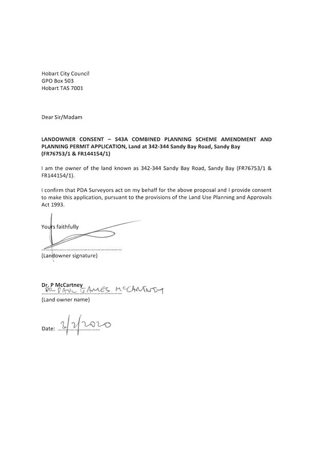
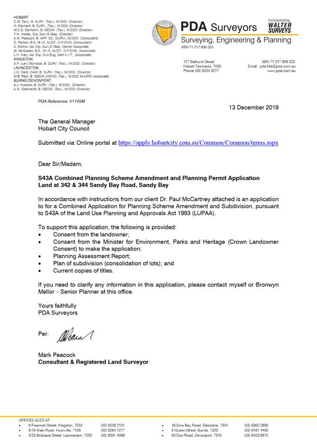
1.1. The purpose of this report is to consider an application under the provisions of the Land Use Planning and Approvals Act 1993 (LUPAA), from PDA Surveyors on behalf of Dr Paul McCartney to amend the Hobart Interim Planning Scheme 2015 (HIPS 2015) by rezoning part of the property at 324 Sandy Bay Road from Open Space to General Residential, and part of an adjacent area of Crown Land from Environmental Management to General Residential. The amendment is described in the applicant’s submission in Attachment B.
1.2. Pursuant to s43A of LUPAA, the planning scheme amendment application is combined with a planning permit application for ‘subdivision (lot consolidation)’ The Development Appraisal Planner’s report is provided in Attachment A, and the applicant’s submission is provided in Attachment B.
1.3. The proposal benefits the community by ensuring that land is appropriately zoned and that development and use is undertaken in a fair an orderly manner.
2. Report Summary
2.1. The proposal is to rezone the existing lot at 342 Sandy Bay Road, Sandy Bay (title reference: CT 76753/1) from Open Space to General Residential to align with the zoning of the remainder of the property at 344 Sandy Bay Road (title reference CT 144154/1). A section of Crown Land to the north-east of 342 Sandy Bay Road, which contains part of an existing boat shed, is proposed to be rezoned from Environmental Management to General Residential.
2.2. It is also proposed that overlay of Heritage Precinct SB8, which covers the existing subject site, be extended to cover the area of Crown Land that will be rezoned to General Residential.
2.3. A development application for subdivision (lot consolidation) has also been submitted, and will be considered concurrently with the proposed amendment. The report relating to the development application is provided in Attachment A.
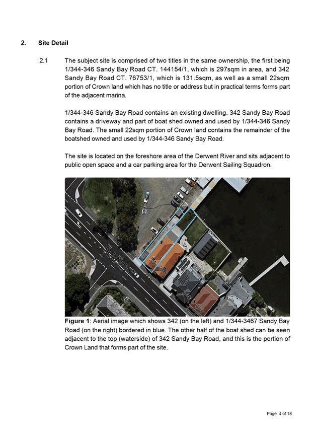
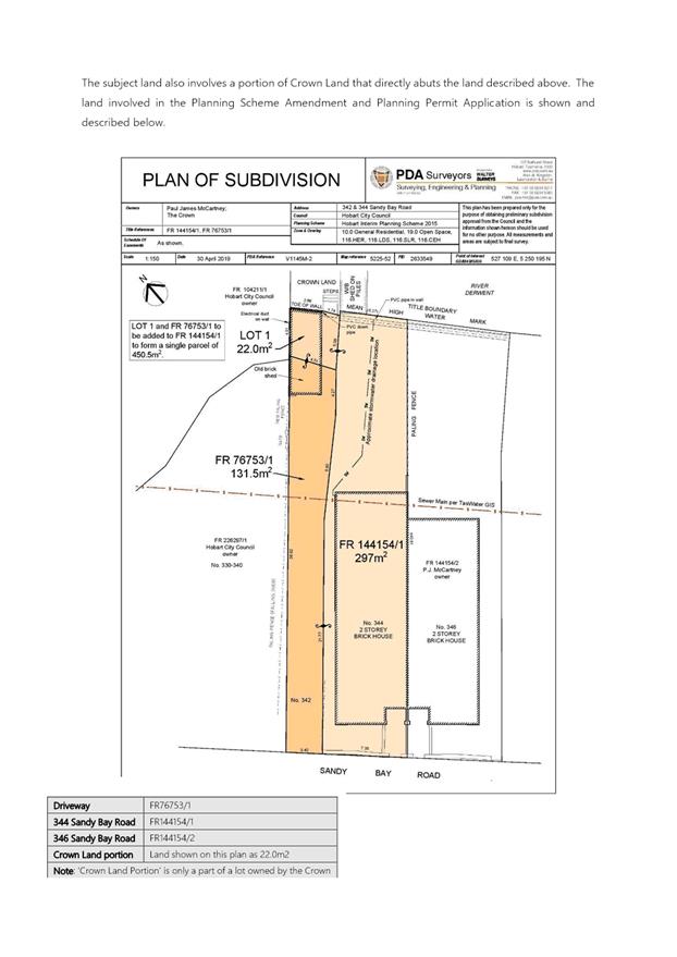
2.4. The subject site includes both 342 and 344 Sandy Bay Road and currently contains one of two conjoined dwellings, a driveway, rear open yard and a boat shed. The site includes two titles, CT 76753/1 (no.342) containing the driveway and part of the boat shed, and CT 144154/1 (no. 344) containing the dwelling and yard. The other part of the boat shed is sited on a portion of Crown Land that directly abuts the subject site to the north-east.
2.5. The area of Crown Land containing part of the existing boatshed is proposed to be subdivided and purchased by the owner of 342 and 344 Sandy Bay Road, then adhered together with 342 and 344 Sandy Bay Road to form a single lot that encompasses the whole boat shed, the dwelling, the driveway and the rear open yard. Permission has been granted by the Crown to make the application.
2.6. The subject site is located along the foreshore area in Sandy Bay and sits adjacent to the public space and parking area adjoining the Derwent Sailing Squadron, slipway and marina.
2.7. The site is located on the boundary of the General Residential Zone, Open Space Zone and Environmental Management Zone. The surrounding area is characterised by a mix of uses including single dwellings, multiple dwellings, passive recreation, and community meeting uses.
2.8. The proposed rezoning is considered to be an appropriate amendment to the HIPS 2015 for the following reasons:
2.8.1. The split zoning over the existing boat shed does not represent the longstanding development and use of the land;
2.8.2. Consolidating the subject site as a single zone integrates the existing land use and development on the site;
2.8.3. Removing a small area of the Open Space Zone and Environmental Management Zone is not considered to impede the operation of those zones, given these areas of land are in private usage and were not available for the purposes that those zones envisage.
|
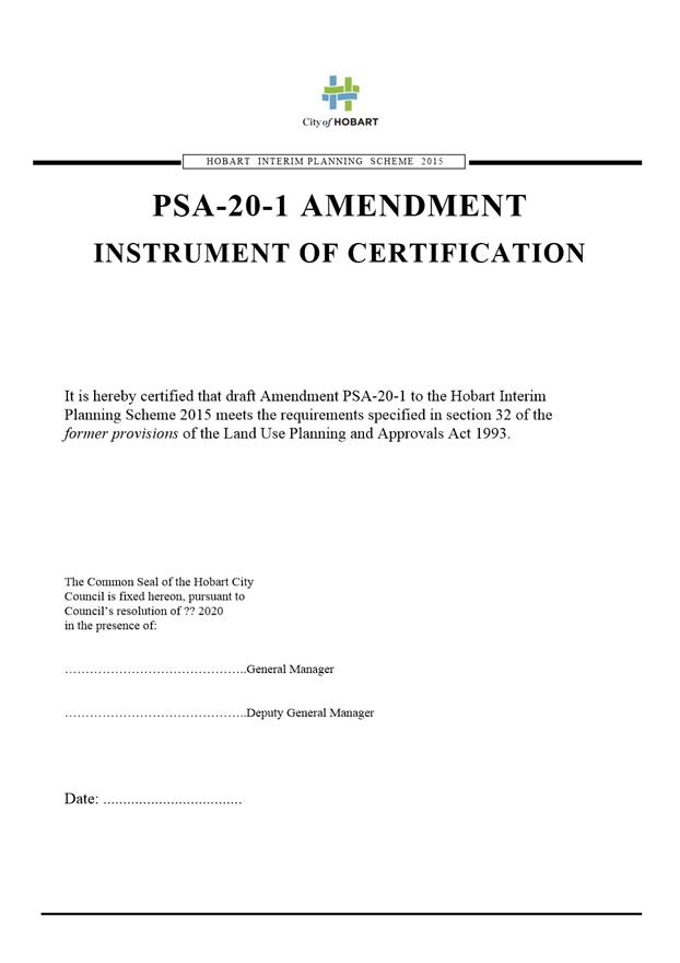
That: 1. Pursuant to Section 34(1) (b) of the former provisions of the Land Use Planning and Approvals Act 1993, the Council resolve to initiate an amendment to the Hobart Interim Planning Scheme 2015 to rezone the property at 342 Sandy Bay Road from Open Space to General Residential, to rezone a portion of adjacent Crown Land from Environmental Management to General Residential, as indicated in the rezoning plans provided in Attachment B, and to extend the Sandy Bay 8 Heritage Precinct overlay across the section of rezoned Crown Land. 2. Pursuant to Section 35 of the former provisions of the Land Use Planning and Approvals Act 1993, the Council certify that the PSA-20-1 Amendment to the Hobart Interim Planning Scheme 2015 meets the requirements of Section 32 of the former provisions of the Land Use Planning and Approvals Act 1993, and authorise the General Manager and the Deputy General Manager to sign the Instrument of Certification marked as Attachment C. 3. Pursuant to Section 38 of the former provisions of the Land Use Planning and Approvals Act 1993, the Council place the PSA-20-1 Amendment to the Hobart Interim Planning Scheme 2015 and PLN-20-146 development application on public exhibition for a 28 day period following certification. 4. Pursuant to Section 43A of the former provisions of the Land Use Planning and Approvals Act 1993, Council grant a permit for Subdivision (Lot Consolidation) at 342 and 344 Sandy Bay Road, Sandy Bay, containing the conditions specified in Attachment A.
|
4. Background
Existing Situation
4.1. The subject site includes both 342 and 344 Sandy Bay Road and currently contains one of two conjoined dwellings, a driveway, rear open yard and a boat shed. The site includes two titles, CT 76753/1 (no. 342) containing the driveway and part of the boat shed and CT 144154/1 (no. 344) containing the dwelling and yard. The other part of the boat shed is sited on a portion of Crown Land that directly abuts the subject site to the north-east.
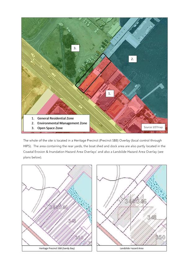
4.2. The land subject to the proposed rezoning (342 Sandy Bay Road, Sandy Bay) is a fully serviced 131.5m2 lot zoned Open Space (see Figure 1).
4.3. The site is located on the boundary with the General Residential Zone, characterised by older houses on small lots or multiple dwellings and the Open Space Zone, characterised by use of land for informal leisure and recreation and community meeting buildings. It also abuts the Environmental Management Zone, which covers part of the River Derwent, including private and public piers and a marina (refer to Figure 1 below).
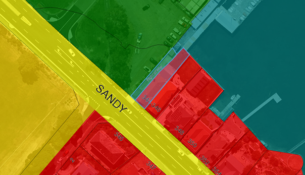
Figure 1: subject site (outlined in blue) showing existing zoning (red: General Residential, green: Open Space, aqua: Environmental Management, dark yellow: Particular Purpose Zone 3 – University of Tasmania (Sandy Bay Campus)).
4.4. The subject site (342 and 344 Sandy Bay Road) contains two titles (CT 76753/1 and CT144154/1). The driveway and boat shed on 342 Sandy Bay Road are related to the use of the dwelling on 344 Sandy Bay Road, which is a two storey c1900 conjoined dwelling.
4.5. Land uses in the immediate area are mixed – predominantly residential to the south and south-east of the site, passive recreation and community meeting and entertainment to the north-west, the University of Tasmania playing fields to the south-west and a large marina projecting into the River Derwent to the east.
4.6. A site investigation submitted by the applicant reveals there is no information to suggest potentially contaminating activities have existed on the subject site. There have been land uses on adjoining sites that have deposited contaminates. Previously testing of soils on the adjoining property have indicated there is little or no potential risk to human and environmental health. However, testing did identify pockets of contaminated soils that require management (if excavated). No excavation is proposed as part of the amendment or development application.
4.7. The subject site is within Sandy Bay Heritage Precinct 8 under the Historic Heritage Code of the HIPS 2015. This heritage area is residential in nature and is significant because of the key historical role of the road in the development of the area, the large number of exceptionally fine residences dating from 1830, the mall number of commercial buildings creating a village character, and the very fine groups of residential buildings representing varying phases of development.
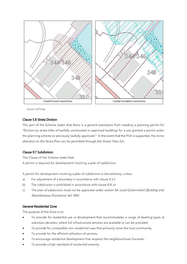
4.8. Between 10m and 7m from the rear boundary of the subject site is covered by the Coastal Hazard Inundation overlay (see figure 2 below) which is classified as ‘low’ coastal inundation hazard. A small portion of the rear boatshed which presently sits on Crown Land, but which is to form part of the proposed subdivision, will fall under the classification of medium coastal hazard inundation hazard. Any future development under this overlay will require assessment under the Inundation Prone Areas Code of the HIPS 2015.
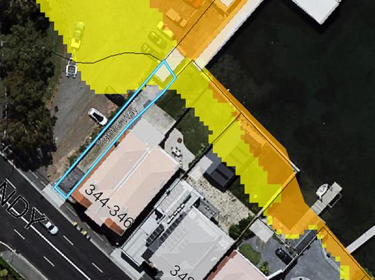
Figure 2: Coastal Inundation Overlay (yellow: ‘low’ risk, orange: ‘medium risk’).
4.9. A small centre portion of the subject site is subject to the Landslide Hazard Band 2013 overlay and classified as ‘low’ landslide hazard (see figure 3 below). Under the Landslide Code of the HIPS 2015 any use or development for buildings or subdivision creating no more than two lots within the low landslide hazard area is considered exempt from assessment. The area of the subject site covered by the Landslide Hazard Band 2013 is not subject to rezoning.
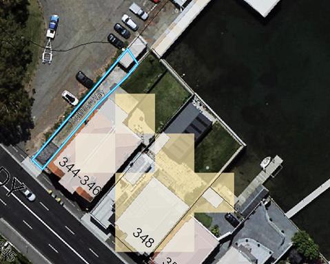
Figure 3: Landslide Hazard Band 2013 (‘low’ risk)
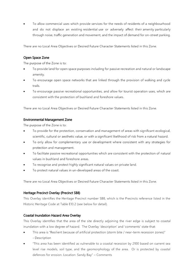
4.10. The Waterway and Coastal Protection Areas overlay extends 40m from the high water mark of tidal waters, which encompasses the entirety of the subject site. Under the Waterway and Coastal Protection Code the proposal is considered exempt under clause 11.4.1 (b) as this application proposes rezoning and development that does not involve clearing of vegetation or soil disturbance.
4.11. Between 10m and 15m of the rear of the subject site is under the Coastal Hazard Band Erosion overlay which is classified as low coastal erosion hazard (see figure 4 below). Any future development under this overlay will require assessment under the Coastal Erosion Hazard Code of the HIPS 2015.
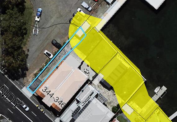
Figure 4: Coastal Hazard Band Erosion overlay (‘low’)
Planning Scheme Provisions
4.12. The Zone Purpose Statement for the Open Space Zone are:
To provide land for open space purposes including for passive recreation and natural or landscape amenity.
To encourage open space networks that are linked through the provision of walking and cycle trails.
To encourage passive recreational opportunities, and allow for tourist operation uses, which are consistent with the protection of bushland and foreshore values.
4.13. Within the Open Space Zone, ‘no permit required’ uses are passive recreation, natural and cultural values management, and utilities (only if minor utilities and underground). There are no ‘permitted’ uses. ‘Discretionary uses’ are community meeting and entertainment, domestic animal breeding, boarding or training (only if for training animals), emergency services, food services, general retail and hire, pleasure boat facility, sports and recreation, tourist operation, visitor accommodation (only if camping and a caravan park or overnight camping area), utilities, and vehicle parking. All other uses are prohibited.
4.14. There are a number of use standards that control the impact of uses in the Open Space Zone, where they are in proximity to the residential zone. Development standards generally relate to the form, function, and safety of buildings and associated landscaping and fencing.
4.15. The Zone Purpose Statements for the Environmental Management Zone are:
To provide for the protection, conservation and management of areas with significant ecological, scientific, cultural or aesthetic value, or with a significant likelihood of risk from a natural hazard.
To only allow for complementary use or development where consistent with any strategies for protection and management.
To facilitate passive recreational opportunities which are consistent with the protection of natural values in bushland and foreshore areas.
To recognise and protect highly significant natural values on private land.
To protect natural values in un-developed areas of the coast.
4.16. Within the Environmental Zone ‘no permit required’ uses are natural and cultural values management, and passive recreation. ‘Permitted’ uses are community meeting and entertainment, educational and occasional care, emergency services, food services, general retail and hire, pleasure boat facility, research and development, residential, sports and recreation, tourist operation, utilities, vehicle parking, and visitor accommodation. All ‘permitted’ uses are conditional upon a reserve management plan applying to their use. ‘Discretionary’ uses community meeting and entertainment, emergency services, extractive industry, pleasure boat facility, port and shipping, research and development, resource development, resource processing, sports and recreation, tourist operation, utilities, vehicle parking, and visitor accommodation.
4.17. The single use standard in the Environmental Management Zone controls the impact of uses on Reserved Land. Development standards generally relate to the form, function, safety, and attractiveness of buildings.
4.18. The Zone Purpose Statements for the General Residential Zone are:
To provide for residential use or development that accommodates a range of dwelling types at suburban densities, where full infrastructure services are available or can be provided.
To provide for compatible non-residential uses that primarily serve the local community.
To provide for the efficient utilisation of services.
To encourage residential development that respects the neighbourhood character.
To provide a high standard of residential amenity.
To allow commercial uses which provide services for the needs of residents of a neighbourhood and do not displace an existing residential use or adversely affect their amenity particularly through noise, traffic generation and movement, and the impact of demand for on-street parking.
4.19. Within the General Residential Zone, single dwellings are ‘no permit required’, with other residential use classes (except more intense home based businesses) and visitor accommodation ‘permitted’. Some non-residential uses such as food services, general retail and hire, and limited business and professional services uses are ‘discretionary’ if not displacing residential uses. A number of community uses such as community meeting and entertainment, educational and occasional care, emergency services, and sport and recreation are also ‘discretionary’.
4.20. Use standards and development standards are aimed towards protecting residential amenity.
5. Proposal and Implementation
5.1. The proposal is to rezone the entire title (CT 76753/1) at 342 Sandy Bay Road from Open Space to Residential. The proposal is to also rezone a portion of Crown Land (which contains part of the existing private boatshed associated with the house at 344 Sandy Bay Road) from Environmental Management to General Residential. The owner of 342-344 Sandy Bay Road intends to purchase this portion of Crown Land.
5.2. The intention is to bring the site into greater uniformity and reflect the existing established development and use of the land, and existing structures built on the land. The area proposed to be rezoned is shown in Figure 5 below.
5.3. It is also proposed that planning approval be granted for subdivision, under s43A of LUPAA, which will extend the boundary of CT 76753/1 to encompass the entirety of the rear boat shed, and to combine this area with CT 76753/1 and CT 144154/1 to form a single parcel of land of approximately 450.5m2 in size.
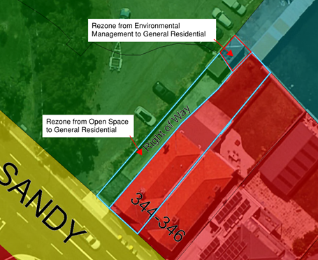
Figure 5: proposed rezoning of 342 Sandy Bay Road and adjacent Crown Land.
Justification – Applicant’s Submission
5.4. The applicant considers that the requested amendment is justified for the following reasons:
5.4.1. The proposed rezoning seeks to correctly reconcile and align long-standing land use and development with ownership, zones and lot layout.
5.4.2. The proposal will provide better cultural heritage protection through appropriate zoning for the consolidation of the boatshed with the dwelling on the site.
5.4.3. The proposal will better conserve the heritage precinct that the subject land is located in by consolidating the dwelling, driveway and boatshed in a single lot.
5.4.4. The subdivision and zoning changes will better and more correctly delineate the line between public and private uses in the surrounding area.
5.4.5. The proposal is consistent with the Schedule 1 Objectives of LUPAA in that:
5.4.5.1. The proposal will promote the sustainable development and maintenance of natural and physical resources by ensuring the whole of the boatshed is located within the boundaries of the site and will help improve the ability for better residential services/infrastructure, which will in turn will protect the riverine environment.
5.4.5.2. The proposal will provide for the fair, orderly and sustainable use and development of air, land and water through resolving the identified planning zone and ownership anomaly.
5.4.5.3. The proposal will encourage public involvement throug the public exhibition of the proposal
5.4.5.4. The proposal will facilitate economic development though better residential services, resolving an identified anomaly and will encourage public involvement
5.4.5.5. The proposal will promote the sharing of responsibility for resource management and planning between spheres of goerment, the community and industry through proceeding with this minor amendment as it provides for the orderly planning of this area. It is sought that the State and Local government agencies support this proposal.
5.4.5.6. The proposal will be consistent with the strategic direction set by State and Local Government policy
5.4.5.7. The submission can be appropriately assessed and determined within the current system of planning instruments
5.4.5.8. The proposal will consolidate ownership and zoning that will further secure the conservation of the heritage precinct and delineate the line between public and private land
5.4.5.9. The proposal will not alter the wording in the planning scheme and will not impact on the integration of policy
5.4.6. The proposal does not contradict the Southern Tasmania Regional Land Use Strategy 2010-2035 (STRLUS) in that, while the strategy seeks to apply an Environmental Management, Recreation or Open Space Zone to vacant land in a coastal area, the subject area is not vacant land and the rezoning will better reflect the existing pattern of zoning in this area (delineating public and private land) and will correct a zone boundary anomaly.
5.4.7. The proposal is consistent with the current provisions of the Hobart Interim Planning Scheme 2015 in that it seeks to better conserve a heritage precinct listed in the Scheme, albeit that the current zoning does not allow it to occur.
5.4.8. The current zoning may have been incorrectly applied in this instance.
Justification – Comment
5.5. The applicant has submitted some valid reasons supporting the proposed rezoning.
5.6. The proposed rezoning of the portion of Crown Land from Environmental Management to General Residential will better reflect the existing and long-standing land use of a private boatshed that was likely constructed around the 1920s.
5.7. With respect to the overlays for Innundation Prone Areas and Coastal Erosion Hazards, the proposal has been reviewed by the Environmental Development Planner and is considered to be acceptable. The rezoning seeks to formalise an existing situation and does not provide significant opportunity for further development. If any further development were to occur within the rezoned areas, it would be subject to assessment under the applicable codes.
5.8. The proposed rezoning of the driveway and part of the boatshed at 342 Sandy Bay Road from Open Space to General Residential recognises that this section of land is for private use, and is not available for public recreation. The Open Space Zone is an inappropriate zone for this lot, and rezoning to General Residential reflects the existing use of the lot in conjunction with the house at 344 Sandy Bay Road.
5.9. The proposed rezoning of two areas of land from public-focused zones to a residentially-focussed zone will clarify the delineation between public and private land and uses in the area.
5.10. As they currently stand, the areas proposed to be rezoned are not capable of meeting the purposes of the Environmental Management and Open Space Zones as they are in private usage for residential purposes. The use of the two areas of land to be rezoned are significantly better aligned to the Zone Purpose Statements of the General Residential Zone. The Crown has consented to the making of the rezoning application.
5.11. Many of the properties along the waterfront in the immediate vicinity of the subject site include protrusions into the River Derwent that are covered by the Environmental Management Zone. In general, these protrusions project beyond the shoreline and would be secured to the riverbed, and therefore the Environmental Management Zone is appropriate to manage impacts of this infrastructure on the river.
5.12. The existing boatshed at 342 Sandy Bay Road is constructed on existing hardstand area that is now part of the shoreline, although likely on reclaimed land. The boatshed does not project further towards the River Derwent than the existing title boundary for the associated dwelling at 344 Sandy Bay Road.
5.13. The existing outbuilding (indoor pool) at the rear of the nearby property at 348 Sandy Bay Road is of similar postion relative to the shoreline and clearly delinieates the separation between private and public through its siting on solid land behind a retaining wall.
5.14. The applicant suggests that the rezoning will assist in preserving heritage values associated with the Heritage Precinct (SB8). In order for this to apply, the boundary of Heritage Precinct SB8 will need to be extended to the proposed new boundary of the consolidated site. It is therefore proposed that, in addition to the rezoning, the extent of th Heritage Precinct Overlay is also amended.
5.15. Extending Heritage Precinct SB8 to cover the entirety of the boatshed will ensure any future development will require assessment under the Historic Heritage Code of the HIPS 2015.
6. Strategic Planning and Policy Considerations
6.1. The proposed amendment is consistent with the objectives of the Capital City Strategic Plan 2019-29, in particular with the following outcomes:
6.1.1. Hobart keeps a strong sense of place and identity, even as the city changes;
6.1.2. In City decision-making, we consider how different aspects of Hobart life connect and contribute to sense of place;
6.1.3. People have a range of opportunities to participate in the economic life of the city;
7. Financial Implications
7.1. Funding Source and Impact on Current Year Operating Result
7.1.1. None.
7.2. Impact on Future Years’ Financial Result
7.2.1. None.
7.3. Asset Related Implications
7.3.1. None.
8. Legal, Risk and Legislative Considerations
8.1. The Land Use Planning and Approvals Act 1993 (LUPAA) requires that planning scheme amendments must seek to further the objectives of Schedule 1 of the Act and be prepared in accordance with State Policies.
8.2. The objectives of the Act require use and development to occur in a fair, orderly and sustainable manner and for the planning process to facilitate economic development in accordance with the other Schedule 1 objectives.
8.3. It is considered that the proposed amendment meets the objectives of LUPAA, in particular it:
8.3.1. Assists sound strategic planning by not prejudicing the achievement of the relevant Zone Objectives or the STRLUS objectives;
8.3.2. Is consistent with the objective to establish a system of planning instruments to be the principal way of setting objectives, policies and controls for the use, development and protection of land;
8.3.3. Provides greater flexibility to address changes in local environmental, social and economic circumstances;
8.3.4. Allows for a more efficient use of the existing infrastructure and facilities;
8.3.5. Is consistent with the objective to provide for the consolidation of approvals for land use and development;
8.3.6. Facilitates the integration of compatible and complementary land use activities in a managed and safe environment;
8.3.7. Provides for the exercise of greater flexibility to fully consider the capability of the land.
8.4. The subject site is located within the ‘coastal zone’ of 1km from the coast, and therefore the State Coastal Policy 1996 applies. The proposed amendment is consistent with the outcomes of this policy as it reflects existing urban residential development on land that is already designated for this use.
8.5. S32(e) of the former provisions of LUPAA requires that planning scheme amendments must avoid the potential for land use conflicts in adjacent planning scheme areas. This amendment is considered to be appropriate in the context of the provisions for surrounding zones, and the existing use and development on land immediately surrounding the site. The rezoning will result in the subject site itself having less potential for land use conflicts, given that it consolidates the site in a single zone. It is not adjacent to any areas controlled by a different planning scheme.
8.6. S32(f) of the former provisions of LUPAA requires that planning scheme amendments must have regard to the impact that the use and development permissible under the amendment will have on the use and development of the region as an entity in environmental, economic and social terms. The size, location and configuration of the land proposed for rezoning is such that it will not have any regional implications.
8.7. S30O of LUPAA requires that an amendment to an interim planning scheme is as far as practicable consistent with the regional land use strategy. It is considered that the amendment is consistent with the Southern Tasmania Regional Land Use Strategy STRLUS in that it:
8.7.1. Adopts a more integrated approach to planning and infrastructure by providing consistent zoning that reflects existing and future uses
8.7.2. Supports the managing of residential growth and zoning
8.7.3. Delineates the separation between private and public land
8.7.4. Creates liveable communities
9. Environmental Considerations
9.1. The proposed amendment is not considered to have any significant environmental impacts given the development and use is already existing.
10. Social and Customer Considerations
10.1. The proposal is not considered to have any negative impact on social inclusion.
11. Marketing and Media
11.1. There are no marketing or branding implications of this amendment.
12. Community and Stakeholder Engagement
12.1. Council has requested that reports which recommend the initiation of planning scheme amendments address the need to conduct a public meeting or forum to explain the proposed amendments and also outline the explanatory information to be made available. These are addressed below
12.1.1. It is not considered that a public forum is necessary to explain the proposed amendment to the public as it is relatively simple and self-explanatory.
12.1.2. The following information will be made available on the website: a copy of this report, a copy of the formal amendment document and the applicant’s submission.
13. Delegation
13.1. Delegation rests with the Council
As signatory to this report, I certify that, pursuant to Section 55(1) of the Local Government Act 1993, I hold no interest, as referred to in Section 49 of the Local Government Act 1993, in matters contained in this report.
|
Michael McClenahan Assistant Planner |
Sarah Crawford Development Planner |
Date: 11 March 2020
File Reference: F20/17870; PSA-20-1
Attachment a: Development
Application Assessment ⇩ ![]()
Attachment
b: Applicant's
Submission ⇩ ![]()
Attachment
c: Instrument
of Certification ⇩ ![]()
|
Item No. 8.1 |
Agenda (Open Portion) City Planning Committee Meeting - 16/3/2020 |
Page 387 ATTACHMENT a |
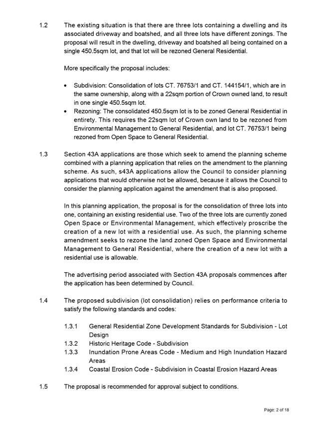


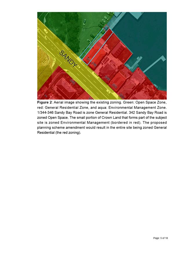
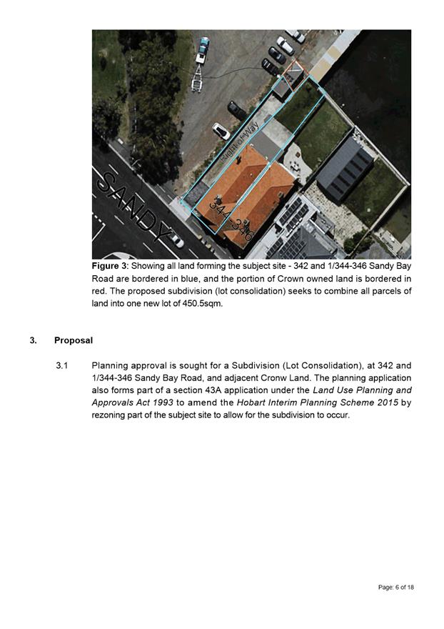
|
Agenda (Open Portion) City Planning Committee Meeting - 16/3/2020 |
Page 412 ATTACHMENT b |
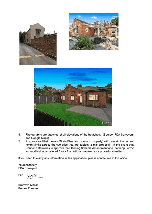
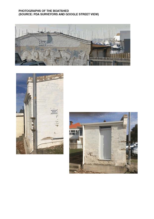
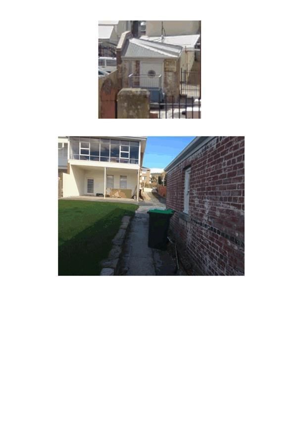
|
Agenda (Open Portion) City Planning Committee Meeting - 16/3/2020 |
Page 432 ATTACHMENT c |
|
Item No. 8.2 |
Agenda (Open Portion) City Planning Committee Meeting |
Page 433 |
|
|
16/3/2020 |
|
8.2 Projected Population and Economic Growth Model
Report of the Senior Advisor Economic Development and the Director Community Life of 10 March 2020.
Delegation: Council
|
Item No. 8.2 |
Agenda (Open Portion) City Planning Committee Meeting |
Page 441 |
|
|
16/3/2020 |
|
REPORT TITLE: Projected Population and Economic Growth Model
REPORT PROVIDED BY: Senior Advisor Economic Development
Director Community Life
1. Report Purpose and Community Benefit
1.1. The purpose of this report is to investigate the development of a useable model of projected population and economic growth for the Greater Hobart region.
1.2. The use of such a model to assist with Council decision-making would provide assurances to the community that decision-making is based on quality and up-to-date data and analysis.
2. Report Summary
2.1. At its meeting held on 1 April 2019, the Council resolved that:
1. A report be prepared into the development of a usable model of projected population and economic growth of the Greater Hobart region. This modelling tool is to be integrated into Hobart City Council planning, infrastructure, strategy development and decision-making.
2. The report also consider using the United Nations Sustainable Development Goals as a framework to achieve sustainable development.
2.2. This report is a response to the above resolution.
2.3. The Council has access to a number of data sets and tools including:
· The Tasmanian Treasury population projections through to 2042.
· Aurin which is a Federal Government funded data workbench providing governments and universities with access to 5000+ multi-disciplinary datasets from hundreds of data sources.
· Profile ID which is a Tasmanian Government funded resource providing public access to a user-friendly dashboard of Local Government Area (LGA), regional and state level data largely derived from the Australian Bureau of Statistics.
· Economic Gaps and Opportunities report by AEC Group covering Greater Hobart (including industry growth and decline projections). This was commissioned by all of the Greater Hobart councils plus Brighton.
2.4. Although these sources are very useful and can provide insights into the changing requirements of the city, such requirements are dynamic and the majority of the available data provides only a snapshot in time which can become dated quickly.
2.5. Should the Council be seeking to inform a specific decision at a key point in time, additional modelling of existing data would need to be undertaken to ensure it was current and considered the impact of the specific decision.
2.5.1. There is not a one size fits all model that would be able to constantly provide the Council with data for a wide range of decision making scenarios. This is a specialist requirement and would need to be and has in the past been commissioned externally.
2.6. Recruiting an in-house resource to provide data, modelling and advice was considered. Continuing to commission external parties however is still considered to be the best option for a number of reasons discussed later in this report.
2.7. In terms of using the United Nations Sustainable Development Goals (SDGs) as a framework to achieve sustainable development, this is being considered in the development of the City’s strategic measurement framework.
|
That: 1. The Council continues to commission specialist external economic data, modelling and analysis as specific situations arise requiring it. 2. The Council notes that the United Nations’ Sustainable Development Goals are being considered in the development of the City’s strategic measurement framework.
|
4. Background
4.1. At its meeting held on 1 April 2019, the Council resolved that:
1. A report be prepared into the development of a usable model of projected population and economic growth of the Greater Hobart region. This modelling tool is to be integrated into Hobart City Council planning, infrastructure, strategy development and decision-making.
2. The report also consider using the United Nations Sustainable Development Goals as a framework to achieve sustainable development.
4.2. The rationale for the notice of motion is as follows:
“We as a Council are being asked to make significant decisions on planning and infrastructure matters without proper information on the projected population and economic growth of Hobart. We need this information readily in order to future-proof our decisions for our community. In light of the housing crisis, climate change and the significant growth Hobart has already undergone in recent years, it is poor governance to consider things like implementing a height limit or moving the university into the CBD without knowing what the future requirements of the city are.”
4.3. The Council has access to a number of data sets and tools to aid in the gathering, analysis and presentation of complex data. Some of this information is open access and some is only available to government entities. Key resources are:
Tasmanian Treasury Population Projections
4.3.1. The Tasmanian Treasury in 2017 released their population projections to 2042. Three series have been projected indicating high, medium and low growth scenarios. The projections have been prepared using the Regional Population Projection Program (RePPP) designed by Dr Tom Wilson of Charles Darwin University. Dr Wilson is a leading demographic modeller. The projections are modelled to LGA level.
Aurin
4.3.2. Aurin is a resource available to Australian government employees, as well as people employed by and studying at university. Aurin provides access to 5000+ data sets and provides researchers with the ability to be able to cross reference and interrogate data in order to answer their research questions. Aurin data includes demographics and social indicators, economic activity and productivity, urban design, housing, liveability and infrastructure. Aurin also enables the user to display their data on maps of the region in question.
Two Council officers took part in a half day training on Aurin earlier in 2019. The range of data and flexibility of the system to enable analysis of bespoke questions was impressive. It became apparent however that Aurin is a tool for qualified and experienced data analysts and researchers. The data is complex and extensive and the way in which the data can be compared is not intuitive. Aurin provides step-by-step guides to certain scenarios which can be followed but generating an answer to a research question specific to the City of Hobart is much more difficult and beyond the skill and capacity of the economic development team.
Profile ID
4.3.3. Profile ID is a user-friendly interface with demographic and population data (largely census based). Access to this tool has been funded by the Tasmanian Government for a period of three years (to 2022).
4.3.3.1. Data has been split into community, social atlas and economic and the dashboard allows a user to easily access and compare data at LGA level with other LGAs and the State.
4.3.3.2. There is also an economic modelling tool (with access limited to government employees only) that enables the estimate of flow on effects of changes of employment or sales within specific industries. Other economic tools available include calculating the economic impact of an event and location quotient analysis that gives an indication of industry specialisations in regions. The tools have been developed by the National Institute of Economic and Industry Research (NIEIR).
4.3.3.3. Profile ID is user-friendly but much of the data is from the 2016 census. The tool provides data but not analytical insights. The range of scenarios that the tool can model are limited.
Economic Gaps and Opportunities Analysis
4.3.4. The City of Hobart along with Kingborough Council, the City of Clarence, the City of Glenorchy and Brighton Council have commissioned an economic study looking at the region as a whole as well as each LGA. AEC Group has used its expertise to provide employment projections to 2051.
Specific Analysis
4.4. It is felt that all of the data sources listed can assist Elected Members in understanding future requirements of the city.
4.4.1. As is often the case with projections however, as time goes on they can appear to be quite different to actual population and economic growth. This is because events and scenarios can take place that cannot realistically be anticipated. An example is the visit to Tasmania of the President of China Xi Jinping and the effect this had on Chinese visitor numbers. Another example is the effect that MONA has had on the creative and tourism industries in Tasmania.
4.5. For this reason, it is recommended that when a decision must be made by Elected Members in relation to the city, economic research would need to be conducted into the economy and population at that point, as well as analysis in terms of the specific economic impact of the decision.
4.6. This kind of analysis is conducted fairly regularly by the City of Hobart. Examples over the last two years are:
· Economic impact of Street Eats Franko (early 2018)
· Taste of Tasmania Economic Impact Report (February 2018)
· Salamanca Market stallholder survey (January 2019)
· Economic Gaps and Opportunities Study of Greater Hobart (May 2019)
· Precinct Plan (October 2019)
· International Relations Measurement System (October 2019)
4.7. Given the regularity the Council commissions such research, discussions have been had about the potential of pooling funding to recruit an in-house resource and building capacity within the Council. Upon investigation, it was concluded that the best option for the Council is still to commission data, modelling and analysis from external sources. This is for the following reasons:
4.7.1. Consultants are a step removed from the Council which can create the perception that they are more impartial and in some cases more qualified to give advice.
4.7.2. Should the Council receive what it perceived to be inadequate advice from an external consultancy, the Council would have the option to legally pursue the consultancy for compensation. This would not be an option with in-house advice.
4.7.3. Many of the economic consultancies such as AEC Group, Deloitte and SGS Economics have developed their own models for estimating a number of things such as industry growth (employment numbers), population growth, export / import demand etc., all of which have an impact on the city. These models have been developed by experts and are protected assets. If the Council was to employ an individual, they would not have access to this intellectual property.
4.8. In terms of using the United Nations Sustainable Development Goals (SDGs) as a framework to achieve sustainable development, this is being considered in the development of the City’s strategic measurement framework. A project plan is currently being reviewed by the General Manager.
5. Proposal and Implementation
5.1. It is proposed that the Council continues to commission data, modelling and analysis from external economic consultancies as situations arise requiring specific advice.
6. Strategic Planning and Policy Considerations
6.1. Examining ways in which the Council can access the most up-to-date data and analysis in terms of their decision making is in line with Pillar 8 of the Capital City Strategic Plan 2019-29 that works towards the following outcome:
8.1 Hobart is a city of best practice, ethical governance and transparent decision-making, specifically
8.1.4 Make effective use of research, evaluation and data to inform the City’s work and respond to trends and changes.
6.2. This report also speaks closely to Pillar 4 of the Capital City Strategic Plan 2019-29:
4.5 Hobart’s economy is strong, diverse and resilient, specifically
4.5.1 Understand and respond to the strategic context of the Hobart economy at regional, state, national and international levels.
7. Financial Implications
7.1. Funding Source and Impact on Current Year Operating Result
7.1.1. There is no impact on this year’s current operating result as external economic advice has been budgeted for in different areas of the Council.
7.2. Impact on Future Years’ Financial Result
7.2.1. Estimations of financial impact are difficult to provide as often situations arise requiring data and advice that cannot be anticipated.
7.3. Asset Related Implications
7.3.1. There are no asset related implications associated with this matter.
8. Legal, Risk and Legislative Considerations
8.1. Commissioning external economic advice reduces the risk when compared with employing an in-house resource as legal recourse would be available to the Council should external advice not be deemed adequate.
9. Environmental Considerations
9.1. Many of the 17 SDGs are related to environmental sustainability. Examples are:
· Goal 6: Clean water and sanitation.
· Goal 7: Affordable and clean energy.
· Goal 11. Sustainable cities and communities.
· Goal 13. Climate action.
9.1.2. Considering these goals in the context of the City’s Strategic Measurement Framework would frame the environment as a high Council and community priority.
10. Social and Customer Considerations
10.1. When decisions are made by the Council in relation to matters of sensitivity such as building heights, it would provide comfort to the community to know that Elected Members had accessed the most up-to-date data and analysis available.
11. Marketing and Media
11.1. As per the Council’s Strategic Plan 2019-29, part of the Council’s brand is to achieve outcome 8.1 which is for Hobart as a city of best practice, ethical governance and transparent decision making. Ensuring decision makers have access to the best available data and analysis in their decision-making will help to contribute to that.
12. Community and Stakeholder Engagement
12.1. The authors have consulted with the Director City Innovation and Manager City Information in the writing of this report.
13. Delegation
13.1. This matter is one for the Council.
As signatory to this report, I certify that, pursuant to Section 55(1) of the Local Government Act 1993, I hold no interest, as referred to in Section 49 of the Local Government Act 1993, in matters contained in this report.
|
Lucy Knott Senior Advisor Economic Development |
Tim Short Director Community Life |
Date: 10 March 2020
File Reference: F19/153991
|
Item No. 8.3 |
Agenda (Open Portion) City Planning Committee Meeting |
Page 442 |
|
|
16/3/2020 |
|
8.3 City Planning - Advertising Report
Memorandum of the Director City Planning of 11 March 2020 and attachment.
Delegation: Committee
|
Item No. 8.3 |
Agenda (Open Portion) City Planning Committee Meeting |
Page 443 |
|
|
16/3/2020 |
|

Memorandum: City Planning Committee
City Planning - Advertising Report
Attached is the advertising list for the period 24 February 2020 to 6 March 2020.
|
That: 1. That the information be received and noted.
|
As signatory to this report, I certify that, pursuant to Section 55(1) of the Local Government Act 1993, I hold no interest, as referred to in Section 49 of the Local Government Act 1993, in matters contained in this report.
|
Neil Noye Director City Planning |
|
Date: 11 March 2020
File Reference: F20/27208
Attachment a: City
Planning - Advertising Report ⇩ ![]()
|
Item No. 8.3 |
Agenda (Open Portion) City Planning Committee Meeting - 16/3/2020 |
Page 446 ATTACHMENT a |
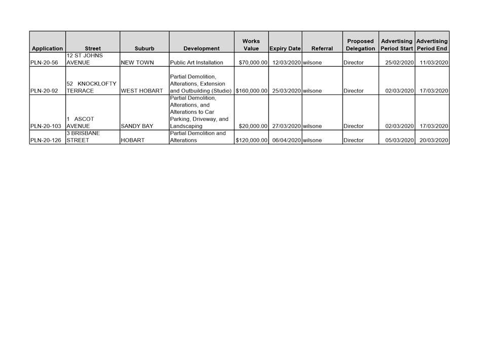
|
Agenda (Open Portion) City Planning Committee Meeting |
Page 447 |
|
|
|
16/3/2020 |
|
8.4 Delegated Decisions Report (Planning)
Memorandum of the Director City Planning of 11 March 2020 and attachment.
Delegation: Committee
|
Item No. 8.4 |
Agenda (Open Portion) City Planning Committee Meeting |
Page 448 |
|
|
16/3/2020 |
|

Memorandum: City Planning Committee
Delegated Decisions Report (Planning)
Attached is the delegated planning decisions report for the period 25 February 2020 to 10 March 2020.
|
That: 1. That the information be received and noted.
|
As signatory to this report, I certify that, pursuant to Section 55(1) of the Local Government Act 1993, I hold no interest, as referred to in Section 49 of the Local Government Act 1993, in matters contained in this report.
|
Neil Noye Director City Planning |
|
Date: 11 March 2020
File Reference: F20/27261
Attachment a: Delegated
Decisions Report (Planning) ⇩ ![]()
|
Item No. 8.4 |
Agenda (Open Portion) City Planning Committee Meeting - 16/3/2020 |
Page 450 ATTACHMENT a |

|
Agenda (Open Portion) City Planning Committee Meeting |
Page 451 |
|
|
|
16/3/2020 |
|
8.5 Monthly Building Statistics - 1 February - 29 February 2020
Memorandum of the Director City Planning of 11 March 2020 and attachments.
Delegation: Council
|
Item No. 8.5 |
Agenda (Open Portion) City Planning Committee Meeting |
Page 453 |
|
|
16/3/2020 |
|
Memorandum: City Planning Committee
Monthly Building Statistics - 1 February - 29 February 2020
Attached is the monthly building statistics for the period 1 February to 29 February 2020.
|
That:
The Director City Planning reports:
During the period 1 February 2020 to 29 February 2020, 37 permits were issued to the value of $6,405,825 which included:
(i) 22 for Extensions/Alterations to Dwellings to the value of $2,446,825;
(ii) 4 New Dwellings to the value of $1,900,000; and
(iii) No Major Projects.
During the period 1 February 2019 to 28 February 2019, 50 permits were issued to the value of $64,030,867 which included:
(i) 22 for Extensions/Alterations to Dwellings to the value of $4,192,867;
(ii) 10 New Dwellings to the value of $4,064,500; and
(iii) 4 Major Projects:
(a) 34 Davey Street, Hobart - Commercial Extension (Parliament Square) - $46,300,000; (b) 2 Churchill Avenue, Sandy Bay - New Commercial Building (University of Tasmania, Base Building Only) - $4,000,000; (c) 42 Argyle Street, Hobart - Commercial Internal Alterations (New Lift), $1,600,000; (d) 11 Franklin Wharf, Hobart - Commercial Internal Alterations (Night Club), $1,500,000;
1. In the twelve months ending 29 February 2020, 599 permits were issued to the value of $243,723,952; and
2. In the twelve months ending 28 February 2019, 657 permits were issued to the value of $541,936,072.
|
As signatory to this report, I certify that, pursuant to Section 55(1) of the Local Government Act 1993, I hold no interest, as referred to in Section 49 of the Local Government Act 1993, in matters contained in this report.
|
Neil Noye Director City Planning |
|
Date: 11 March 2020
File Reference: F20/27307
Attachment a: 2019
Building Application Types - amended ⇩ ![]()
Attachment
b: Building
Permits Value ⇩ ![]()
Attachment
c: Building
Permits Issued ⇩ ![]()
Attachment
d: New
Dwellings - Monthly Comparisons ⇩ ![]()
|
Item No. 8.5 |
Agenda (Open Portion) City Planning Committee Meeting - 16/3/2020 |
Page 454 ATTACHMENT a |
|
Item No. 8.5 |
Agenda (Open Portion) City Planning Committee Meeting - 16/3/2020 |
Page 455 ATTACHMENT b |
|
Item No. 8.5 |
Agenda (Open Portion) City Planning Committee Meeting - 16/3/2020 |
Page 456 ATTACHMENT c |
|
Item No. 8.5 |
Agenda (Open Portion) City Planning Committee Meeting - 16/3/2020 |
Page 457 ATTACHMENT d |
|
|
Agenda (Open Portion) City Planning Committee Meeting |
Page 458 |
|
|
16/3/2020 |
|
Section 29 of the Local Government (Meeting Procedures) Regulations 2015.
File Ref: 13-1-10
An Elected Member may ask a question without notice of the Chairman, another Elected Member, the General Manager or the General Manager’s representative, in line with the following procedures:
1. The Chairman will refuse to accept a question without notice if it does not relate to the Terms of Reference of the Council committee at which it is asked.
2. In putting a question without notice, an Elected Member must not:
(i) offer an argument or opinion; or
(ii) draw any inferences or make any imputations – except so far as may be necessary to explain the question.
3. The Chairman must not permit any debate of a question without notice or its answer.
4. The Chairman, Elected Members, General Manager or General Manager’s representative who is asked a question may decline to answer the question, if in the opinion of the respondent it is considered inappropriate due to its being unclear, insulting or improper.
5. The Chairman may require a question to be put in writing.
6. Where a question without notice is asked and answered at a meeting, both the question and the response will be recorded in the minutes of that meeting.
7. Where a response is not able to be provided at the meeting, the question will be taken on notice and
(i) the minutes of the meeting at which the question is asked will record the question and the fact that it has been taken on notice.
(ii) a written response will be provided to all Elected Members, at the appropriate time.
(iii) upon the answer to the question being circulated to Elected Members, both the question and the answer will be listed on the agenda for the next available ordinary meeting of the committee at which it was asked, where it will be listed for noting purposes only.
|
|
Agenda (Open Portion) City Planning Committee Meeting |
Page 459 |
|
|
16/3/2020 |
|