City
of hobart
AGENDA
City Planning Committee Meeting
Open Portion
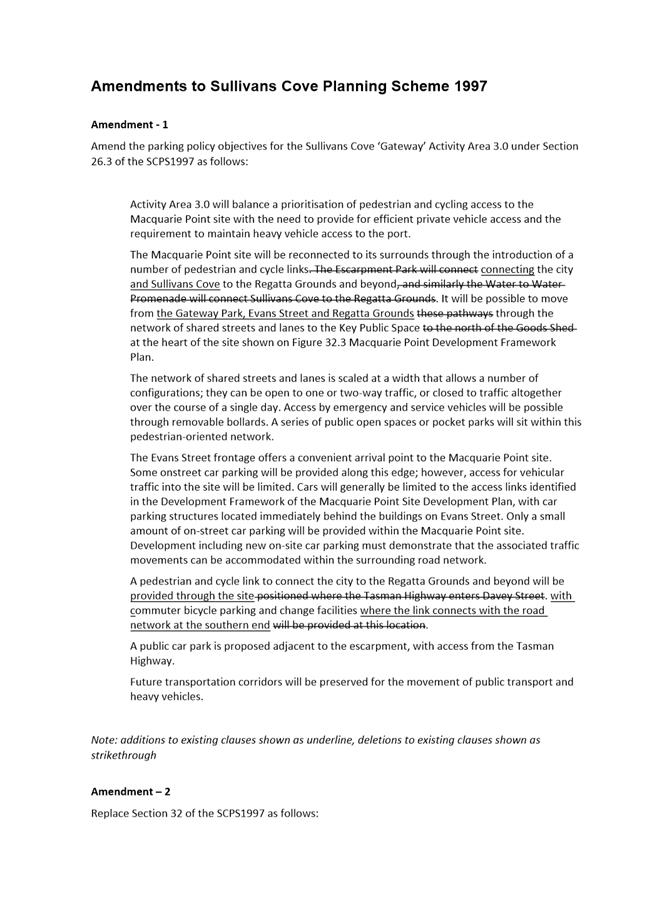
Monday, 27 May 2019
at 5:00 pm
Lady Osborne Room, Town Hall
City
of hobart
AGENDA
City Planning Committee Meeting
Open Portion
Monday, 27 May 2019
at 5:00 pm
Lady Osborne Room, Town Hall
THE MISSION
Our mission is to ensure good governance of our capital City.
THE VALUES
The Council is:
|
about people |
We value people – our community, our customers and colleagues. |
|
professional |
We take pride in our work. |
|
enterprising |
We look for ways to create value. |
|
responsive |
We’re accessible and focused on service. |
|
inclusive |
We respect diversity in people and ideas. |
|
making a difference |
We recognise that everything we do shapes Hobart’s future. |
|
|
Agenda (Open Portion) City Planning Committee Meeting |
Page 3 |
|
|
27/5/2019 |
|
Business listed on the agenda is to be conducted in the order in which it is set out, unless the committee by simple majority determines otherwise.
APOLOGIES AND LEAVE OF ABSENCE
1. Co-Option of a Committee Member in the event of a vacancy
3. Consideration of Supplementary Items
4. Indications of Pecuniary and Conflicts of Interest
6. Planning Authority Items - Consideration of Items With Deputations
7. Committee Acting as Planning Authority
7.1 Applications under the Hobart Interim Planning Scheme 2015
7.1.1 18 Aotea Road, Sandy Bay - Change of Use to Visitor Accommodation
8.3 Delegated Decisions Report (Planning)
8.4 City Planning Advertising Report
10. Closed Portion Of The Meeting
|
|
Agenda (Open Portion) City Planning Committee Meeting |
Page 4 |
|
|
27/5/2019 |
|
City Planning Committee Meeting (Open Portion) held Monday, 27 May 2019 at 5:00 pm in the Lady Osborne Room, Town Hall.
|
COMMITTEE MEMBERS Deputy Lord Mayor Burnet (Chairman) Briscoe Denison Harvey Behrakis
NON-MEMBERS Lord Mayor Reynolds Zucco Sexton Thomas Dutta Ewin Sherlock |
Apologies:
Leave of Absence: Deputy Lord Mayor Burnet (Chairman)
|
|
The minutes of the Open Portion of the City Planning Committee meeting held on Monday, 13 May 2019, are submitted for confirming as an accurate record.
|
Ref: Part 2, Regulation 8(6) of the Local Government (Meeting Procedures) Regulations 2015.
|
That the Committee resolve to deal with any supplementary items not appearing on the agenda, as reported by the General Manager.
|
Ref: Part 2, Regulation 8(7) of the Local Government (Meeting Procedures) Regulations 2015.
Members of the Committee are requested to indicate where they may have any pecuniary or conflict of interest in respect to any matter appearing on the agenda, or any supplementary item to the agenda, which the Committee has resolved to deal with.
Regulation 15 of the Local Government (Meeting Procedures) Regulations 2015.
A Committee may close a part of a meeting to the public where a matter to be discussed falls within 15(2) of the above regulations.
In the event that the committee transfer an item to the closed portion, the reasons for doing so should be stated.
Are there any items which should be transferred from this agenda to the closed portion of the agenda, or from the closed to the open portion of the agenda?
In accordance with the requirements of Part 2 Regulation 8(3) of the Local Government (Meeting Procedures) Regulations 2015, the General Manager is to arrange the agenda so that the planning authority items are sequential.
In accordance with Part 2 Regulation 8(4) of the Local Government (Meeting Procedures) Regulations 2015, the Committee by simple majority may change the order of any of the items listed on the agenda, but in the case of planning items they must still be considered sequentially – in other words they still have to be dealt with as a single group on the agenda.
Where deputations are to be received in respect to planning items, past practice has been to move consideration of these items to the beginning of the meeting.
RECOMMENDATION
That in accordance with Regulation 8(4) of the Local Government (Meeting Procedures) Regulations 2015, the Committee resolve to deal with any items which have deputations by members of the public regarding any planning matter listed on the agenda, to be taken out of sequence in order to deal with deputations at the beginning of the meeting.
|
|
Agenda (Open Portion) City Planning Committee Meeting |
Page 6 |
|
|
27/5/2019 |
|
In accordance with the provisions of Part 2 Regulation 25 of the Local Government (Meeting Procedures) Regulations 2015, the intention of the Committee to act as a planning authority pursuant to the Land Use Planning and Approvals Act 1993 is to be noted.
In accordance with Regulation 25, the Committee will act as a planning authority in respect to those matters appearing under this heading on the agenda, inclusive of any supplementary items.
The Committee is reminded that in order to comply with Regulation 25(2), the General Manager is to ensure that the reasons for a decision by a Council or Council Committee acting as a planning authority are recorded in the minutes.
|
Agenda (Open Portion) City Planning Committee Meeting |
Page 7 |
|
|
|
27/5/2019 |
|
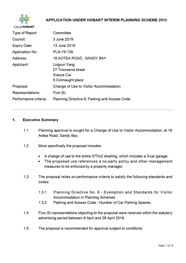
7.1 Applications under the Hobart Interim Planning Scheme 2015
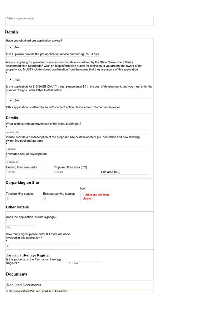
7.1.1 18 Aotea Road, Sandy Bay - Change of Use to Visitor Accommodation
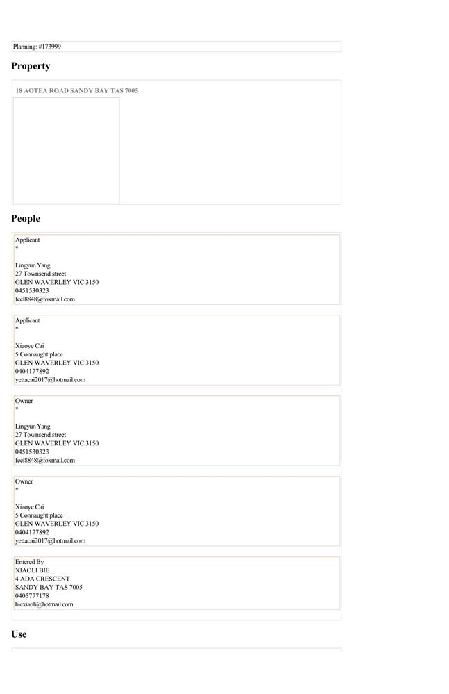
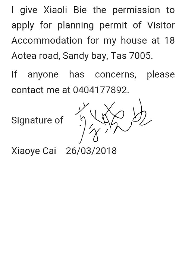
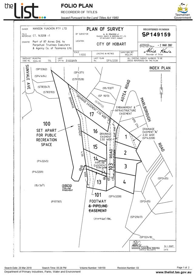
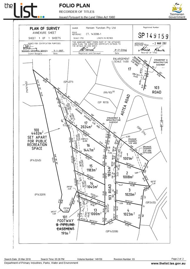
Address: 18 Aotea Road, Sandy Bay
Proposal: Change of Use to Visitor Accommodation
Expiry Date: 13 June 2019
Extension of Time: Not applicable
Author: Cameron Sherriff
|
REcommendation That pursuant to the Hobart Interim Planning Scheme 2015, the Council approve the application for change of use to visitor accommodation at 18 Aotea Road, Sandy Bay for the reasons outlined in the officer’s report and a permit containing the following conditions be issued:
GEN
The use and/or development must be substantially in accordance with the documents and drawings that comprise PLN19126 18 AOTEA ROAD SANDY BAY TAS 7005 Final Planning Documents except where modified below.
Reason for condition
To clarify the scope of the permit.
PLN 18
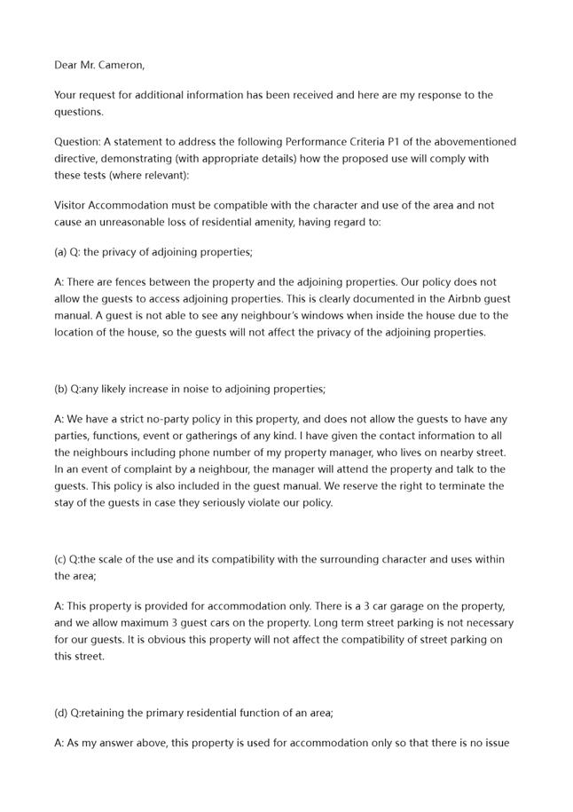
Prior to the commencement of the approved use, a management plan for the operation of the visitor accommodation must be submitted and approved, to the satisfaction of the Council's Director City Planning. The management plan must include measures to limit, manage and mitigate unreasonable impacts upon the amenity of permanent residents. These measures must include, but are not limited to, the following requirements:
1. A strict noparty policy, preventing events such as disruptive parties, functions, gatherings or otherwise to occur on site;
2. An appropriate waste management protocol, including removal of rubbish after each booking;
3. To limit, manage, and mitigate noise generated by the visitor accommodation;
4. To limit, manage, and mitigate behavioural issues associated with the visitor accommodation;
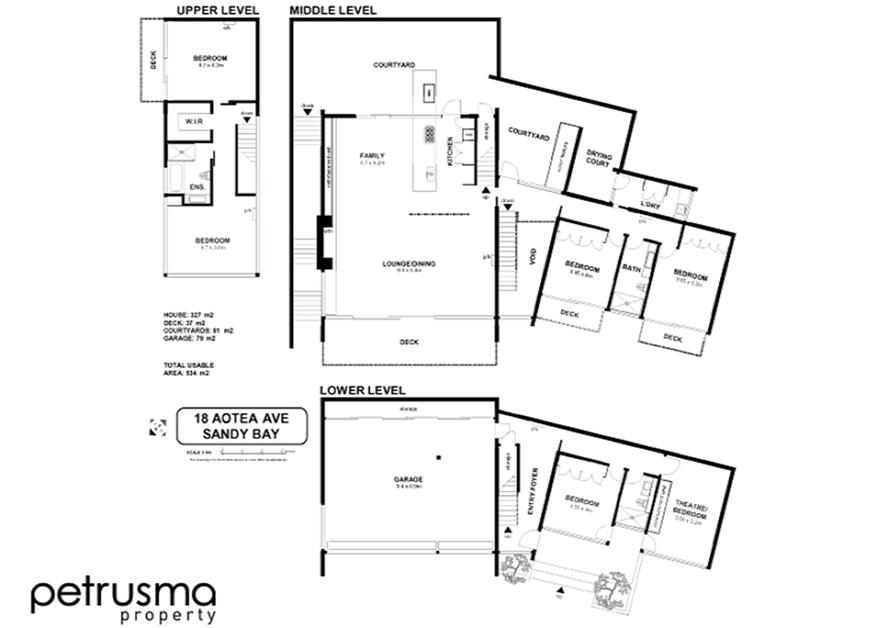
5. To specify the maximum permitted occupancy of the visitor accommodation. The accommodation must not be offered to more than twelve (12) guests, occupying up to six (6) rooms, at any one time;
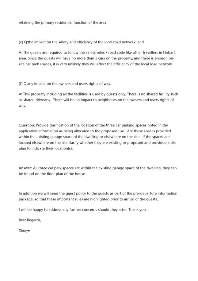
6. To specify the maximum number of vehicles to be associated with guests, their type and where they must be parked. Guests using the accommodation must have a maximum of three (3) standard vehicles that are all capable of being driven onto the site. The management plan must also specify that those vehicles are all parked on the site at all times in the existing garage spaces or elsewhere upon the site. Guests bringing their own vehicle/s must utilise on site parking spaces and vehicles must not be left parked in surrounding streets. Mini buses or coaches must not be allowed to be retained near the site by guests and can be used for drop off or pick up only.
Once accepted by the Council, the management plan must be:
1. Circulated by the property owner, at a minimum, to all adjoining properties and those directly opposite across Aotea Road;
2. Implemented prior to the commencement of the approved use; and
3. Maintained for as long as the visitor accommodation is in operation.
Once approved, the management plan must be implemented prior to the commencement of the approved use and must be maintained for as long as the visitor accommodation is in operation.
Reason for condition
To ensure that visitor accommodation does not cause an unreasonable loss of residential amenity.
ADVICE
The following advice is provided to you to assist in the implementation of the planning permit that has been issued subject to the conditions above. The advice is not exhaustive and you must inform yourself of any other legislation, bylaws, regulations, codes or standards that will apply to your development under which you may need to obtain an approval. Visit the Council's website for further information.
Prior to any commencement of work on the site or commencement of use the following additional permits/approval may be required from the Hobart City Council.
VISITOR ACCOMMODATION
More information on visitor accommodation, including when building approval is required, can be found here.
In all cases, check with your insurance company that you have adequate cover.
If you are in a bushfire prone area there may be a need to create/review the Bushfire Management Hazard Plan for your property.
|
Attachment a: PLN-19-126
- 18 AOTEA ROAD SANDY BAY TAS 7005 - Planning Committee or Delegated Report ⇩ ![]()
Attachment
b: PLN-19-126
- 18 AOTEA ROAD SANDY BAY TAS 7005 - CPC Agenda Documents ⇩ ![]()
|
Item No. 7.1.1 |
Agenda (Open Portion) City Planning Committee Meeting - 27/5/2019 |
Page 10 ATTACHMENT a |

|
Agenda (Open Portion) City Planning Committee Meeting - 27/5/2019 |
Page 25 ATTACHMENT b |

|
Item No. 7.1.1 |
Agenda (Open Portion) City Planning Committee Meeting - 27/5/2019 |
Page 33 ATTACHMENT b |
|
Item No. 7.1.1 |
Agenda (Open Portion) City Planning Committee Meeting - 27/5/2019 |
Page 34 ATTACHMENT b |
|
Item No. 7.1.2 |
Agenda (Open Portion) City Planning Committee Meeting |
Page 36 |
|
|
27/5/2019 |
|
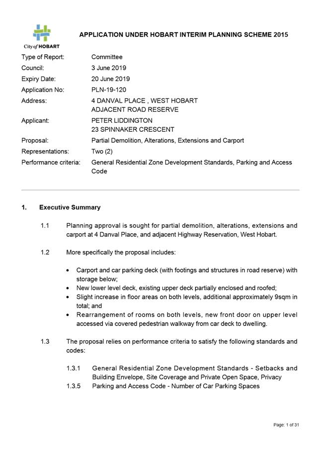
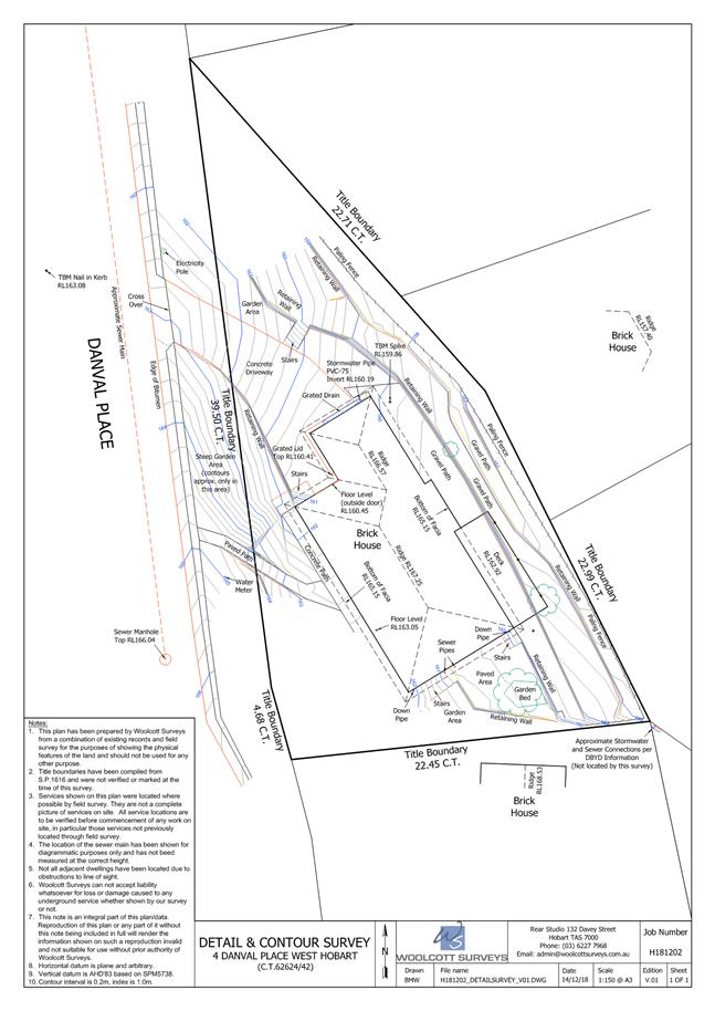
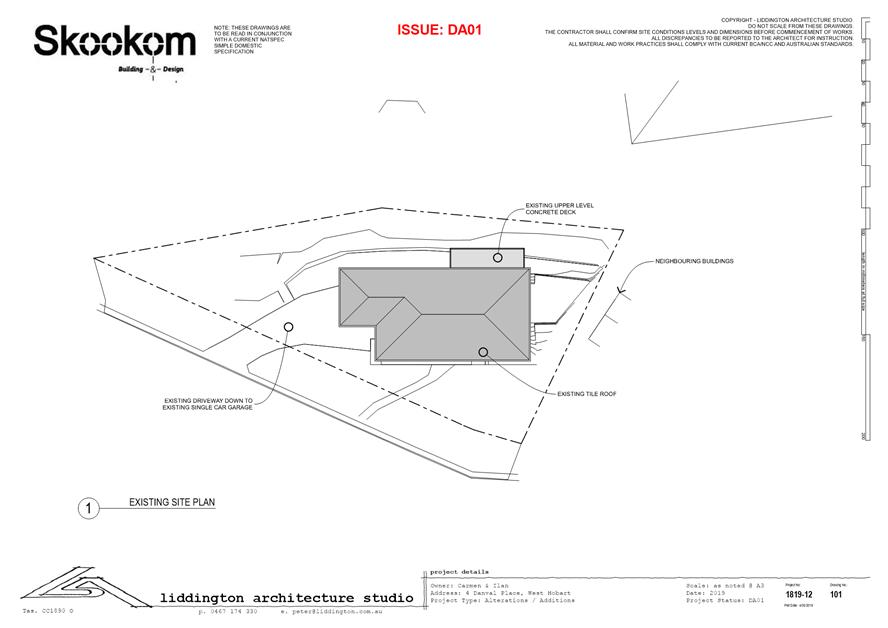
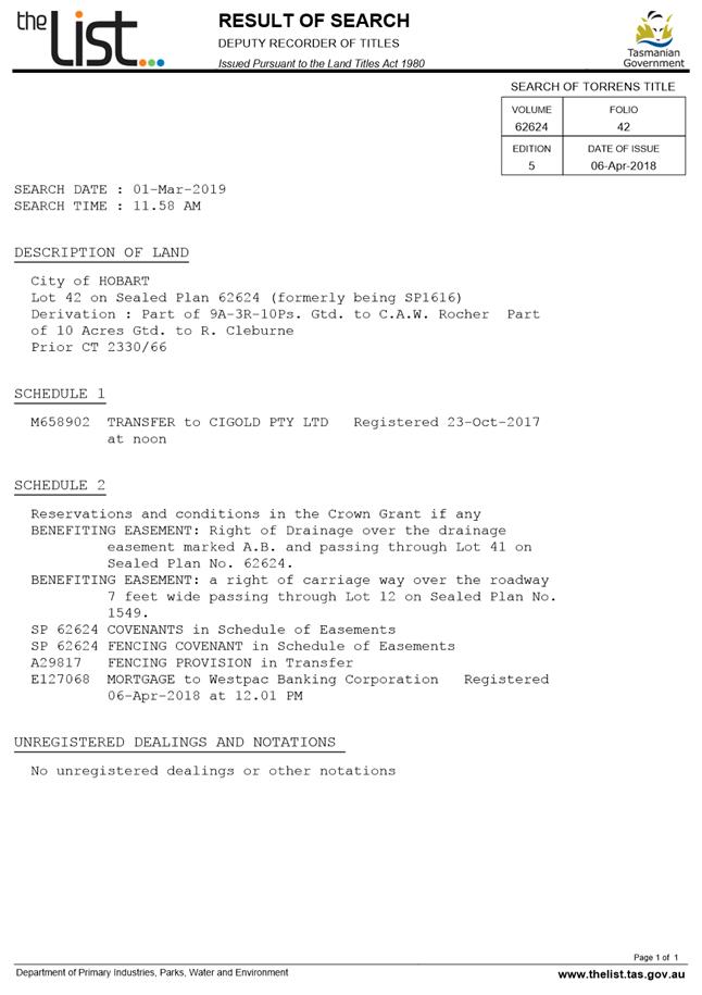
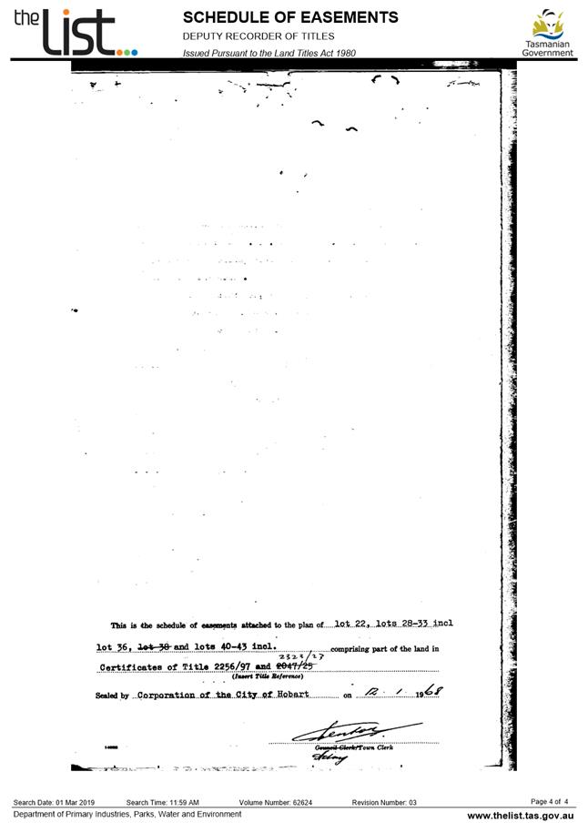
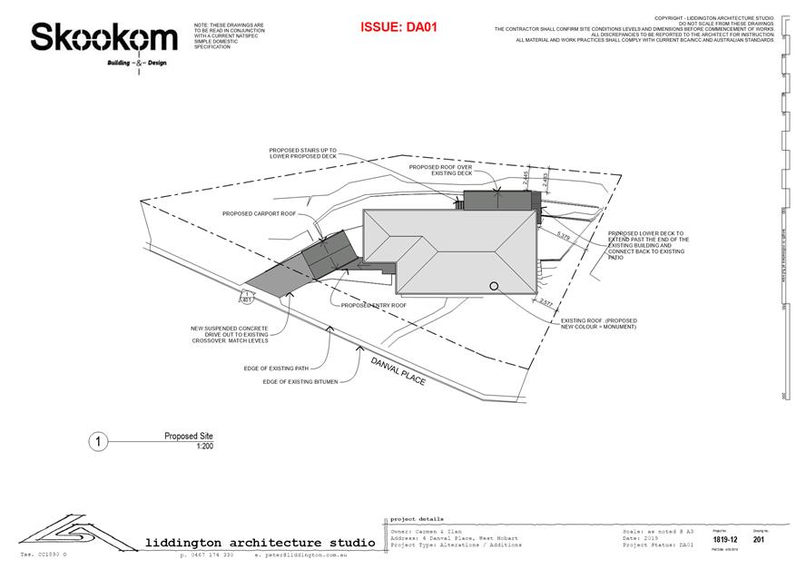
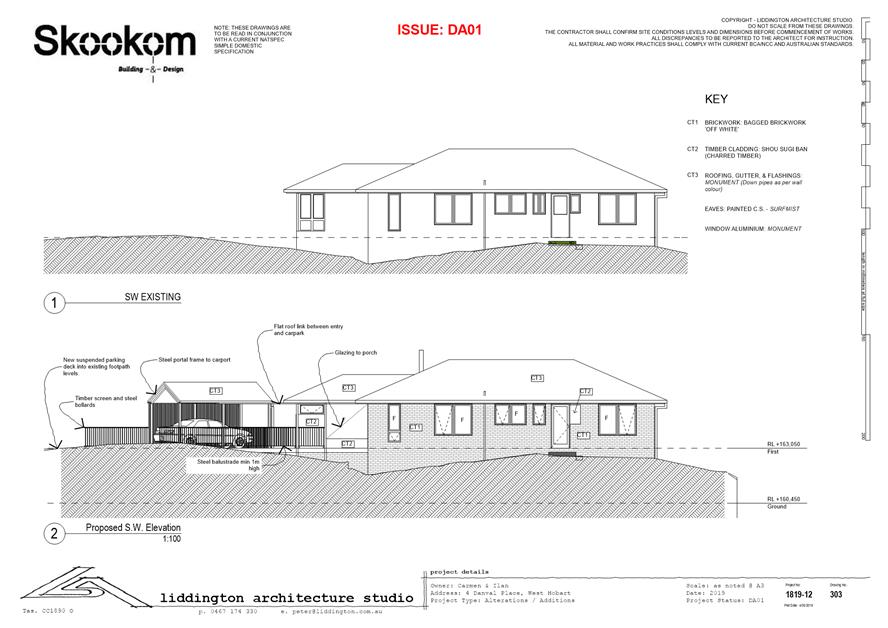
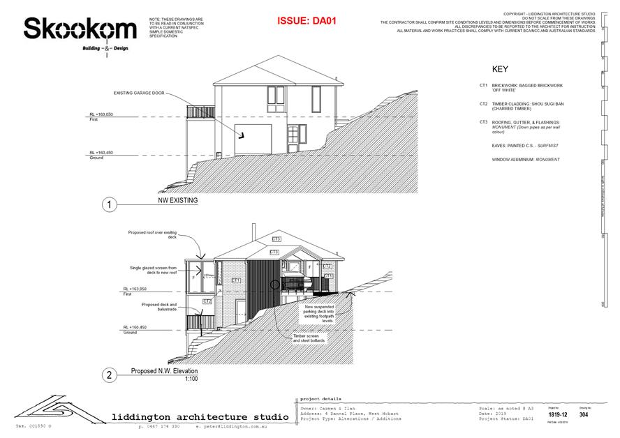
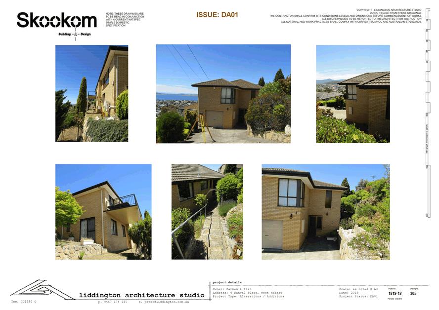
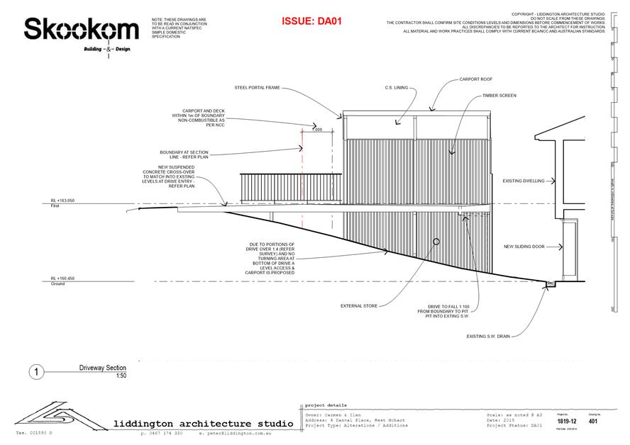
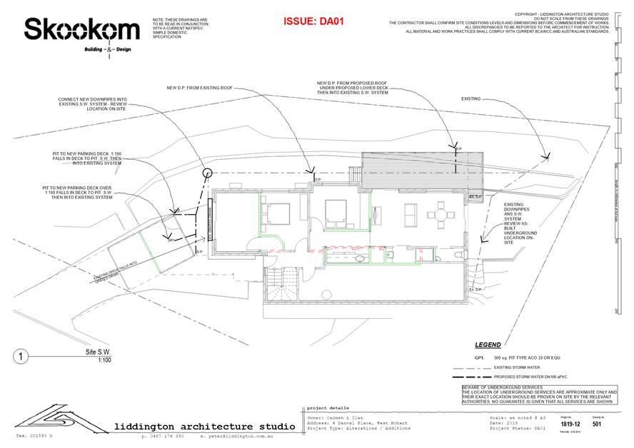
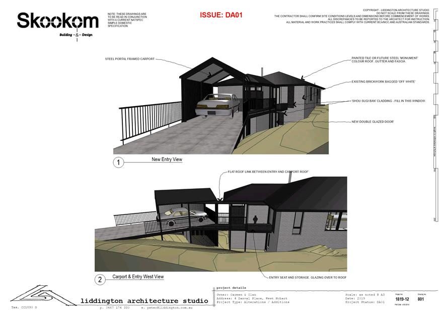
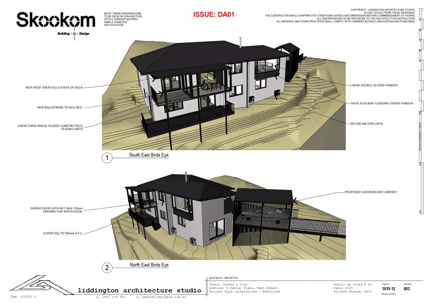
7.1.2 4 Danval Place, West Hobart and Adjacent Road Reserve - Partial Demolition, Alterations, Extensions and Carport
Address: 4 Danval Place, West Hobart and Adjacent Road Reserve
Proposal: Partial Demolition, Alterations, Extensions and Carport
Expiry Date: 20 June 2019
Extension of Time: Not applicable
Author: Michelle Foale
|
REcommendation That pursuant to the Hobart Interim Planning Scheme 2015, the Council approve the application for partial demolition, alterations, extensions and carport at 4 Danval Place, and adjacent highway reservation, West Hobart for the reasons outlined in the officer’s report and a permit containing the following conditions be issued:
GEN
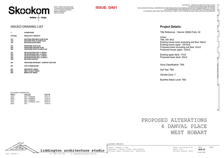
The use and/or development must be substantially in accordance with the documents and drawings that comprise PLN19120 4 DANVAL PLACE WEST HOBART TAS 7000 Final Planning Documents except where modified below.
Reason for condition
To clarify the scope of the permit.
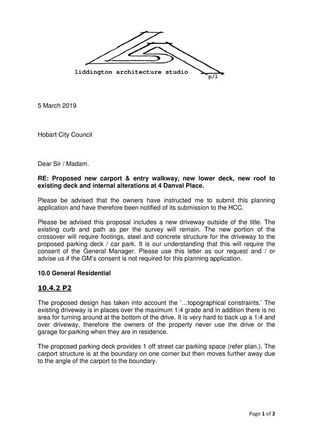
PLN s4
The car port must be reduced in height and bulk.
Prior to the issue of any approval under the Building Act 2016, revised plans must be submitted and approved to the satisfaction of the Director City Planning, in accordance with the above requirements. The revised plans must show the following:
1. The car port roof design must be a single plane/skillion design with a maximum height of no more than 2.7m from the car parking deck level (RL+163 050); and
2. The timber slats on the north eastern elevation of the car port must be only below the standard balustrade.
All work required by this condition must be undertaken in accordance with the approved revised plans.
Reason for condition
To provide relative consistency in the apparent scale, bulk, massing and proportion of dwellings (and outbuildings) in the area.
ENG sw1
All stormwater from the proposed development (including but not limited to: roofed areas, ag drains, retaining wall ag drains and impervious surfaces such as driveways and paved areas) must be drained to the Council’s stormwater infrastructure prior to first occupation or commencement of use (whichever occurs first).
Reason for condition
To ensure that stormwater from the site will be discharged to a suitable Council approved outlet.
ENG 2a
Prior to first occupation or commencement of use (whichever occurs first), vehicular barriers compliant with the Australian Standard AS/NZS1170.1:2002 must be installed to prevent vehicles running off the edge of an access driveway or parking module (parking spaces, aisles and manoeuvring area) where the drop from the edge of the trafficable area to a lower level is 600mm or greater, and wheel stops (kerb) must be installed for drops between 150mm and 600mm. Barriers must not limit the width of the driveway access or parking and turning areas approved under the permit.
Advice: The Council
does not consider a slope
greater than 1 in 4 to constitute a lower level as described in AS/NZS
2890.1:2004 Section 2.4.5.3. Slopes greater than 1 in 4 will require a vehicular barrier or wheel stop. Designers are advised to consult the National Construction Code 2016 to determine if pedestrian handrails or safety barriers compliant with the NCC2016 are also required in the parking module this area may be considered as a path of access to a building.
Reason for condition
To ensure the safety of users of the access driveway and parking module and compliance with the standard.
ENG 2b
Prior to the issue of any approval under the Building Act 2016 or the commencement of works on site (whichever occurs first), a certified vehicle barrier design (including site plan with proposed location(s) of installation) prepared by a suitably qualified engineer, compliant with Australian Standard AS/NZS1170.1:2002, must be submitted to Council.
Advice: If the development's building approval includes the need for a Building Permit from Council, the applicant is advised to submit
detailed design of vehicular barrier as part of the Building Application. If the development's building approval is covered under Notifiable Work the applicant is advised to submit detailed design of vehicular barrier as a condition endorsement of the planning permit condition. Once the certification has been accepted, the Council will issue a condition endorsement (see general advice on how to obtain condition endorsement).
Reason for condition
To ensure the safety of users of the access driveway and parking module and compliance with the standard.
ENG 2c
Prior to the commencement of use, vehicular barriers must be inspected by a qualified engineer and certification submitted to the Council confirming that the installed vehicular barriers comply with the certified design and Australian Standard AS/NZS1170.1:2002.
Advice: Certification may be submitted to the Council as part of the Building Act 2016 approval process or via condition endorsement (see general advice on how to obtain condition endorsement).
Reason for condition
To ensure the safety of users of the access driveway and parking module and compliance with the relevant standards.
ENG 3a
The access driveway and parking module (parking spaces, aisles and manoeuvring area) must be designed and constructed in accordance with Australian Standard AS/NZS2890.1:2004 (including the requirement for vehicle safety barriers where required), or a Council approved alternate design certified by a suitably qualified engineer to provide a safe and efficient access, and enable safe, easy and efficient use.
Advice: It is advised that designers consider the detailed design of the access and parking module prior to finalising the Finished Floor Level (FFL) of the parking spaces (especially if located within a garage incorporated into the dwelling), as failure to do so may result in difficulty complying with this condition.
Reason for condition
To ensure the safety of users of the access and parking module, and compliance with the relevant Australian Standard.
ENG 3b
The access driveway and parking module (parking spaces, aisles and manoeuvring area) design must be submitted and approved, prior to the issuing of any approval under the Building Act 2016.
The access driveway and parking module (parking spaces, aisles and manoeuvring area) design must:
1. Be prepared and certified by a suitably qualified engineer.
2. Be in accordance with the Australian Standard AS/NZS2890.1:2004.
3. Where the design deviates from AS/NZS2890.1:2004, demonstrate that the design will provide a safe and efficient access, and enable safe, easy and efficient use including endorsement from Council's City Amenity Division.
4. Show dimensions, levels, gradients and transitions, and other details as Council deem necessary to satisfy the above requirement.
Advice: It is advised that designers consider the detailed design of the access and parking module prior to finalising the Finished Floor Level (FFL) of the parking spaces (especially if located within a garage incorporated into the dwelling), as failure to do so may result in difficulty complying with this condition.
Once the design has been approved, the Council will issue a condition endorsement (see general advice on how to obtain condition endorsement) Where building approval is also required, it is recommended that documentation for condition endorsement be submitted well before submitting documentation for building approval. Failure to address condition endorsement requirements prior to submitting for building approval may result in unexpected delays.
Reason for condition
To ensure the safety of users of the access and parking module, and compliance with the relevant Australian Standard.
ENG 3c
The access driveway and parking module (parking spaces, aisles and manoeuvring area) must be constructed in accordance with the design drawings approved by Condition ENG 3b and ENG r1.
Prior to the commencement of use, documentation by a suitably qualified engineer certifying that the access driveway and parking module has been constructed in accordance with the above drawings must be lodged with Council.
Advice: Certification may be submitted to Council as part of the Building Act 2016 approval process or via condition endorsement (see general advice on how to obtain condition endorsement)
Reason for condition
To ensure the safety of users of the access and parking module, and compliance with the relevant Australian Standard.
ENG 4
The access driveway and parking module (car parking spaces, aisles and manoeuvring area) approved by this permit must be constructed to a sealed standard (spray seal, asphalt, concrete, pavers or equivalent Council approved) and surface drained to the Council's stormwater infrastructure prior to the commencement of use.
Reason for condition
To ensure the safety of users of the access driveway and parking module, and that it does not detract from the amenity of users, adjoining occupiers or the environment by preventing dust, mud and sediment transport.
ENG 5
The number of car parking spaces approved on the site for use is one (1).
Reason for condition
To ensure the provision of parking for the use is safe and efficient.
ENG 1
Any damage to council infrastructure resulting from the implementation of this permit, must, at the discretion of the Council:
1. Be met by the owner by way of reimbursement (cost of repair and reinstatement to be paid by the owner to the Council); or
2. Be repaired and reinstated by the owner to the satisfaction of the Council.
A photographic record of the Council's infrastructure adjacent to the subject site must be provided to the Council prior to any commencement of works.
A photographic record of the Council’s infrastructure (e.g. existing property service connection points, roads, buildings, stormwater, footpaths, driveway crossovers and nature strips, including if any, preexisting damage) will be relied upon to establish the extent of damage caused to the Council’s infrastructure during construction. In the event that the owner/developer fails to provide to the Council a photographic record of the Council’s infrastructure, then any damage to the Council's infrastructure found on completion of works will be deemed to be the responsibility of the owner.
Reason for condition
To ensure that any of the Council's infrastructure and/or siterelated service connections affected by the proposal will be altered and/or reinstated at the owner’s full cost.
ENG r1
The footings (driveway deck) within the highway reservation must not undermine the stability and integrity of the highway reservation and its infrastructure.
Detailed design drawings and structural certificates of the driveway deck footings within the Danval Place highway reservation must be submitted and approved, prior to the commencement of work and must:
1. Be prepared and certified by a suitable qualified person and experienced engineer;
2. Not undermine the stability of the highway reservation;
3. Take into account any additional surcharge loadings as required by relevant Australian Standards;
4. Take into account and reference accordingly any Geotechnical findings; 5. Detail the design and location of the footing adjacent to Danval Place highway reservation; and
6. Include a structure certificate which notes that the driveway deck footings will not undermine the highway reservation.
All work required by this condition must be undertaken in accordance with the approved select design drawing and structural certificates.
Advice: The applicant is required submit detailed
design documentation to satisfy this condition via Council's planning condition endorsement process
(noting there is a fee associated with condition endorsement approval of engineering drawings [see
general advice on how to obtain condition endorsement and for
fees and charges]). This is a
separate process to
any building approval under the Building Act 2016. Failure to address condition endorsement requirements prior to submitting for building approval may result in unexpected delays.
Reason for condition
To ensure that the stability and integrity of the Council’s highway reservation is not compromised by the development.
ENGR 3
Prior to the commencement of use, the proposed driveway apron within the Danval Place highway reservation must be designed and constructed in accordance with:
· Urban TSDR09v1 – Urban Roads Driveways and TSD R14v1 Type KC vehicular crossing.
· Rural – TSDR04v1 – Rural Roads Typical Driveway Profile and TSD R03v1 Rural Roads Typical Property Access.
· Footpath Urban Roads Footpaths TSDR11v1.
Design drawings must be submitted and approved prior to the commencement of work. The design drawing must:
1. Show the cross and long section of the driveway crossover within the highway reservation and onto the property. 2. Be designed for the expected vehicle loadings. A structural certificate to note that driveway is suitable for heavy vehicle loadings. 3. Demonstrate that a B85 vehicle or B99 depending on use (AS/NZS 2890.1 2004, section 2.6.2) can access the driveway from the road pavement into the property without scraping the cars underside if the design deviates from the requirements of the TSD. 4. Be approved by Council's City Amenity Division should the design deviate from the previously submitted documentation. Note: that the agreement of the Council’s is required to adjust footpath levels. 5. Be prepared and certified by a suitable qualified person, to satisfy the above requirement.
All work required by this condition must be undertaken in accordance with the approved drawings.
Advice: The applicant is required submit detailed
design documentation to satisfy this condition via Council's planning condition endorsement process
(noting there is a fee associated with condition endorsement approval of engineering drawings [see
general advice on how to obtain condition endorsement and for
fees and charges]). This is a
separate process to
any building approval under the Building
Act 2016. Please
note that your
proposal does not
include adjustment of footpath levels. Any adjustment to
footpath levels necessary to suit the
design of proposed floor, parking module or driveway levels will require separate agreement from
Council's Road
Services Engineer and
may require further
planning approvals. It is advised to place a note
to this affect on construction drawings
for the site and/or other relevant engineering drawings to ensure that
contractors are made aware of this requirement. Failure to address condition endorsement requirements prior to submitting for building approval may result in unexpected delays.
Reason for condition
To ensure that works will comply with the Council’s standard requirements.
ENV 1
Sediment and erosion control measures sufficient to prevent sediment from leaving the site must be installed prior to any disturbance of the site, and maintained until all areas of disturbance have been stabilized or revegetated.
Advice: For further guidance in preparing a Soil and Water Management Plan – in accordance with Fact sheet 3 Derwent Estuary Program click here.
Reason for condition
To avoid the sedimentation of roads, drains, natural watercourses, Council land that could be caused by erosion and runoff from the development, and to comply with relevant State legislation.
ADVICE
The following advice is provided to you to assist in the implementation of the planning permit that has been issued subject to the conditions above. The advice is not exhaustive and you must inform yourself of any other legislation, bylaws, regulations, codes or standards that will apply to your development under which you may need to obtain an approval. Visit the Council's website for further information.
Prior to any commencement of work on the site or commencement of use the following additional permits/approval may be required from the Hobart City Council.
CONDITION ENDORSEMENT ENGINEERING
All engineering drawings required to be submitted and approved by this planning permit must be submitted to the City of Hobart as a CEP (Condition Endorsement) via the City’s Online Service Development Portal. When lodging a CEP, please reference the PLN number of the associated Planning Application. Each CEP must also include an estimation of the cost of works shown on the submitted engineering drawings. Once that estimation has been confirmed by the City’s Engineer, the following fees are payable for each CEP submitted and must be paid prior to the City of Hobart commencing assessment of the engineering drawings in each CEP:
Value of Building Works Approved by Planning Permit Fee: Up to $20,000: $150 per application. Over $20,000: 2% of the value of the works as assessed by the City's Engineer per assessment.
These fees are additional to building and plumbing fees charged under the Building and Plumbing Regulations.
Once the CEP is lodged via the Online Service Development Portal, if the value of building works approved by your planning permit is over $20,000, please contact the City’s Development Engineer on 6238 2715 to confirm the estimation of the cost of works shown on the submitted engineering drawings has been accepted.
Once confirmed, pleased call one of the City’s Customer Service Officers on 6238 2190 to make payment, quoting the reference number (ie. CEP number) of the Condition Endorsement you have lodged. Once payment is made, your engineering drawings will be assessed.
BUILDING PERMIT
You may need building approval in accordance with the Building Act 2016. Click here for more information.
This is a Discretionary Planning Permit issued in accordance with section 57 of the Land Use Planning and Approvals Act 1993.
PLUMBING PERMIT
You may need plumbing approval in accordance with the Building Act 2016, Building Regulations 2016 and the National Construction Code. Click here for more information.
OCCUPATION OF THE PUBLIC HIGHWAY
You may require a permit for the occupation of the public highway for construction. Click here for more information.
You may require a Permit to Open Up and Temporarily Occupy a Highway (for work in the road reserve). Click here for more information.
PLANNING
This planning permit is for a single dwelling. It is noted that duplicate living areas, and kitchen facilities have been proposed and approved. This permit does not approve the use of the site as multiple dwellings.
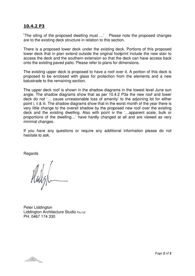
You are encourage to plant and maintain screening vegetation between the new lower level deck close the rear boundary. To screen this deck would improve privacy between this deck and the neighbouring private outdoor space however it would reduce sunlight to the proposed deck and rumpus room.
STORM WATER
Please note that in addition to a building and/or plumbing permit, development must be in accordance with the Hobart City Council’s Hydraulic Services By law. Click here for more information.
WORK WITHIN THE HIGHWAY RESERVATION
Please note development must be in accordance with the Hobart City Council’s Highways By law. Click here for more information.
DRIVEWAY SURFACING OVER HIGHWAY RESERVATION
If a coloured or textured surface is used for the driveway access within the Highway Reservation, the Council or other service provider will not match this on any reinstatement of the driveway access within the Highway Reservation required in the future.
ACCESS
Designed in accordance with LGAT IPWEA – Tasmanian standard drawings. Click here for more information.
CROSS OVER CONSTRUCTION
The construction of the crossover can be undertaken by the Council or by a private contractor, subject to Council approval of the design. Click here for more information.
WORK PLACE HEALTH AND SAFETY
Appropriate occupational health and safety measures must be employed during the works to minimise direct human exposure to potentiallycontaminated soil, water, dust and vapours. Click here for more information.
PROTECTING THE ENVIRONMENT
In accordance with the Environmental Management and Pollution Control Act 1994, local government has an obligation to "use its best endeavours to prevent or control acts or omissions which cause or are capable of causing pollution." Click here for more information.
NOISE REGULATIONS
Click here for information with respect to noise nuisances in residential areas.
WASTE DISPOSAL
It is recommended that the developer liaise with the Council’s Cleansing and Solid Waste Unit regarding reducing, reusing and recycling materials associated with demolition on the site to minimise solid waste being directed to landfill.
Further information regarding waste disposal can also be found on the Council’s website.
FEES AND CHARGES
Click here for information on the Council's fees and charges.
DIAL BEFORE YOU DIG
Click here for dial before you dig information.
|
Attachment
a: PLN-19-120
- 4 DANVAL PLACE WEST HOBART TAS 7000 - Planning Committee or Delegated Report ⇩ ![]()
Attachment
b: PLN-19-120
- 4 DANVAL PLACE WEST HOBART TAS 7000 - CPC Agenda Documents ⇩ ![]()
|
Item No. 7.1.2 |
Agenda (Open Portion) City Planning Committee Meeting - 27/5/2019 |
Page 49 ATTACHMENT a |

|
Agenda (Open Portion) City Planning Committee Meeting - 27/5/2019 |
Page 80 ATTACHMENT b |
|
Item No. 7.1.2 |
Agenda (Open Portion) City Planning Committee Meeting - 27/5/2019 |
Page 82 ATTACHMENT b |
|
Item No. 7.1.2 |
Agenda (Open Portion) City Planning Committee Meeting - 27/5/2019 |
Page 83 ATTACHMENT b |
|
Item No. 7.1.2 |
Agenda (Open Portion) City Planning Committee Meeting - 27/5/2019 |
Page 84 ATTACHMENT b |

|
Item No. 7.1.2 |
Agenda (Open Portion) City Planning Committee Meeting - 27/5/2019 |
Page 101 ATTACHMENT b |
|
Agenda (Open Portion) City Planning Committee Meeting |
Page 108 |
|
|
|
27/5/2019 |
|
8. Reports
8.1 Sullivans Cove Planning Scheme 1997 - Macquarie Point Site Development Plan - Proposed Amendments - Consideration of Representation
Report of the Manager Planning Policy and Heritage and the Director City Planning of 22 May 2019 and attachments.
Delegation: Council
|
Item No. 8.1 |
Agenda (Open Portion) City Planning Committee Meeting |
Page 109 |
|
|
27/5/2019 |
|
REPORT TITLE: Sullivans Cove Planning Scheme 1997 - Macquarie Point Site Development Plan - Proposed Amendments - Consideration of Representation
REPORT PROVIDED BY: Manager Planning Policy and Heritage
Director City Planning
1. Report Purpose and Community Benefit
1.1. This report considers a representation (Attachment A) received in relation to the proposed amendments to the Sullivans Cove Planning Scheme 1997 (SCPS1997) - Macquarie Point Site Development Plan (Attachment B) and also any representation that Council may wish to make in relation to the proposed amendments.
1.2. The proposed amendments benefit the community by ensuring that redevelopment of the site is undertaken in a manner consistent with the strategic objectives of the SCPS1997 and the Macquarie Point Development Corporation Act 2012.
2. Report Summary
2.1. The Tasmanian Government considers that Macquarie Point presents a once in a generation opportunity for Hobart and Tasmania and in 2016 directed the Macquarie Point Development Corporation (MPDC) to reset the vision for the Macquarie Point site and prepare a new plan for development based on the MONA vision.
2.2. Under the new vision the area is to be developed to include public space, exhibition space, commercial space, cultural space, conference facilities, accommodation and facilities to support Hobart’s role as Australia’s Antarctic gateway and tourism infrastructure.
2.3. The proposed amendments to implement the reset vision include changes to the Desired Future Character Statements (32.3), height and siting plan (Figures 32.3 and 32.4), development standards (32.7.3 to 32.7.7) and general considerations (32.4) to implement the height, siting and design concepts from the reset masterplan.
2.4. The MPDC has submitted that the following concepts are embodied in the proposed amendments and are considered to be highly consistent with the Objectives for Urban Form under Section 23.2 of the SCPS1997:
2.4.1. The bulk, height and siting of buildings are to be sympathetic to the natural topography of the headland, escarpment surrounding the Cenotaph and reinforce the natural shoreline;
2.4.2. Maintain important views as identified on Figure 32.4 of the SDP;
2.4.3. Enrich the meaning and memory of the changing nature of Macquarie Point over time through expression of the use and development layers from the past including the topography, natural shoreline, Round House, Goods Shed and Royal Engineers Building;
2.4.4. Develop a network of connections through and around the site including a series of primary shared street spaces extending north from Evans Street towards the centre of the site; and smaller and more intimate secondary spaces. Their position can be adjusted to suit specific development as it unfolds;
2.4.5. Reinforce a well-defined built edge to Evans Street, set back to highlight the Goods Shed as a public entry point to the site;
2.4.6. Built form is to be ‘set in the round’ on the ‘cove floor’;
2.4.7. Buildings are to incorporate articulated roof forms to provide interest when viewed from elevated surrounding areas of the Cenotaph and Domain.
2.5. It is considered that the proposed amendments to the Macquarie Point SDP in the SCPS are an appropriate response to the Tasmanian Governments revised vision for the future use and development of the site.
2.6. The one representation received during the exhibition period was from Ireneinc on behalf of DarkLab and MONA (Attachment A). The representation does not support the inclusion of residential uses on the site because of the potential for land use conflict and the view that there is sufficient land elsewhere in central Hobart for residential development.
2.7. The principal issue of contention with the proposed amendments appears to be the extent of residential use to be allowed on site.
2.8. Council’s position in relation to the draft amendments was that the permitted standard for residential use should remain at 50,000m2 gross floor area rather than be reduced to 15,000m2.
2.9. The MPDC has advised that the physical constraints of the site do not allow for 50,000m2 of residential use and would not allow for the mix of uses which the Government intends for the site or be in keeping with the Government's commitment of the MONA Vision.
2.10. The concerns expressed in the representation about the potential for land use conflict and impacts on residential amenity from large public events do have some merit. The potential impacts can however be alleviated to some extent by the appropriate location of residential use and the design of buildings.
2.11. The amendments include the following standard (32.6.2) which is intended to protect residential amenity and the viability of Macquarie Point as a major public event space:
Residential or Visitor Accommodation development must demonstrate that design elements are able to achieve internal noise levels in accordance with relevant Australian Standards for acoustics control (including AS3671:1989– Road Traffic Noise Intrusion (Building Siting and Construction) and AS2107:2000 – Acoustics (Recommended Design Sound Levels and Reverberation Times for Building Interiors)).
2.12. A new Desired Future Character Statement is also inserted at Clause 32.3.14 to ensure that developments for noise sensitive uses are adequately designed and constructed to protect residential amenity and reduce the potential for land use conflict that may compromise the use of Macquarie Point as a major public event space.
2.13. The response from the MPDC to the Councils submission on the draft amendment, makes it clear that 50,000m2 of residential floor space could not be achieved without a significant change to the Government’s vision for the site. Even if the 50,000m2 figure is retained as the permitted standard, this amount of residential use would not occur unless the Government wants it developed. The standard does not mandate the provision of a certain amount of residential floor space, it simply places a permitted cap on it.
2.14. Despite the potential for land use conflict, it is considered that there are benefits in having some residential use on the site as a permanent residential population will; provide a level of activity when there are no public events, help facilitate development of neighbourhood character and sense of place, improve safety and security and support local businesses.
2.15. It is recommended that the proposed amendments be supported as they are consistent with; the strategic principles of the SCPS1997, the Southern Tasmania Regional Land Use Strategy, relevant State Policies and further the Objectives of LUPAA.
2.16. It is recommended that the representation not be supported as some residential use on the site is considered beneficial.
|
That: 1. Pursuant to section 39H(14) of the Macquarie Point Development Corporation Act 2012, the Council advise the Minister for State Growth that it does not support the representation received from Ireneinc on behalf of DarkLab and MONA in relation to the PSA-19-2 Amendments to the Sullivans Cove Planning Scheme 1997. 2. Council advise the Minister for State Growth that it supports the PSA-19-2 Amendments to the Sullivans Cove Planning Scheme 1997. |
4. Background
4.1. In 2012, the State Government established the MPDC and gave it responsibility for the remediation and redevelopment of most of the land within Activity Area 3.
4.2. Under the Macquarie Point Development Corporation Act 2012, the MPDC is required to plan, facilitate and manage the redevelopment of the site.
4.3. At its meeting of 12 October 2015, the Council initiated amendments to the SCPS which inserted the Macquarie Point SDP, along with other associated amendments to the planning scheme document in order to facilitate implementation of the Macquarie Point Strategic Framework and Masterplan 2015-2030.
4.4. Following a public exhibition and lengthy hearing process, the Tasmanian Planning Commission gave final approval to a modified version of the amendments in November 2016.
4.5. In response to an invitation from the State Government, in December 2016, MONA put forward its vision for the Macquarie Point site focusing on the development of an arts and cultural precinct and a nationally significant Truth and Reconciliation Art Park.
4.6. In response to public feedback and recognising that Macquarie Point presents a once in a generation opportunity for Hobart and Tasmania, the State Government directed the MPDC to reset the vision for the Macquarie Point site and prepare a new plan for development based on the MONA vision. The reset masterplan focuses solely on the first stage of the MONA vision and is confined to the bounds of the existing Site Development Plan in the SCPS1997.
4.7. Under the new vision the area is to be developed to include public space, exhibition space, commercial space, cultural space, conference facilities, accommodation and facilities to support Hobart’s role as Australia’s Antarctic gateway and tourism infrastructure.
4.8. On 17 December 2018, the Parliament of Tasmania passed the Macquarie Point Development Corporation Amendment Act 2018. The intention of this Act was to provide a framework to accelerate investment in, and development of, the Macquarie Point site to reflect a shift in focus from remediation to redevelopment.
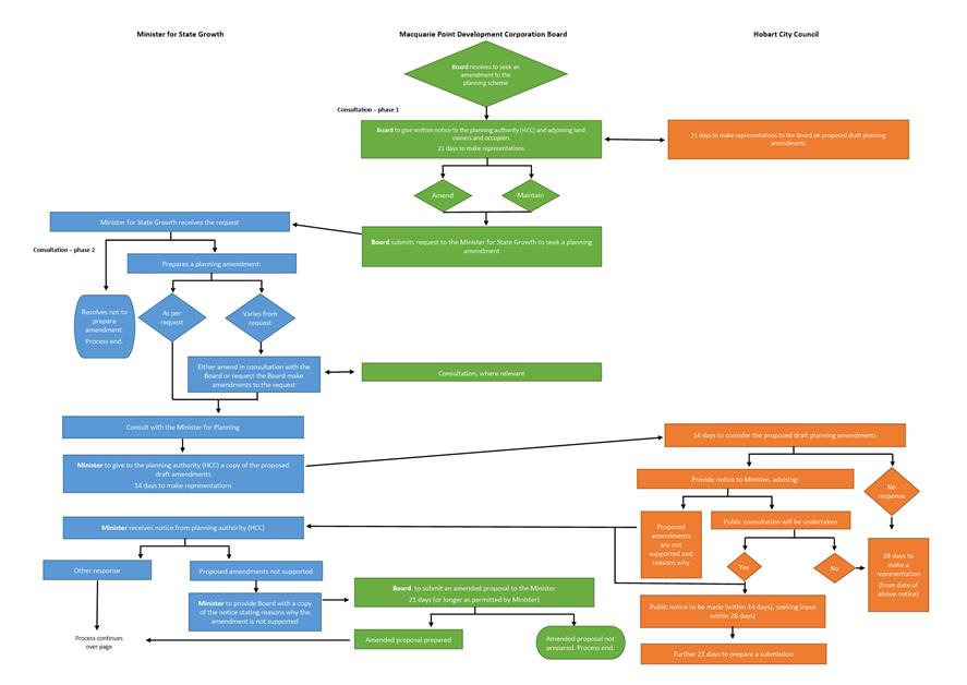
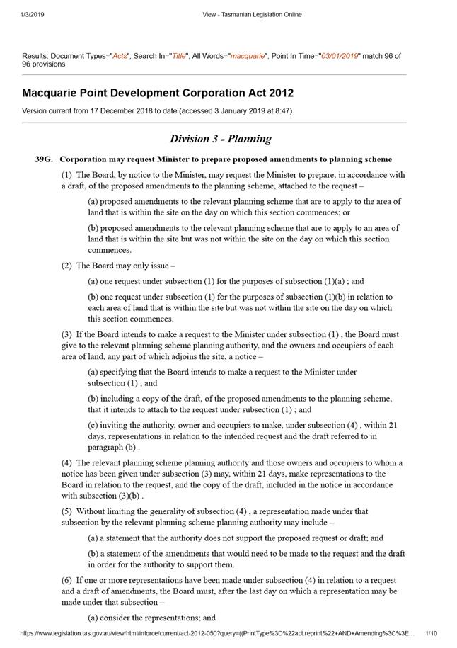
4.9. The Amendment Act also introduced a new process for the Minister for State Growth to amend the SCPS. This process is outlined in the flow chart provided in Attachment C. The relevant MPDC Act provisions are provided in Attachment D.
4.10. At its meeting on 21
January 2019, the Council considered a draft version of the amendments and
resolved to recommend the following changes to the draft:
Council recommends to the Board that:
(i) an additional amendment be included which applies standard A2/P2 in Planning Directive No 6 – Exemption and Standards for Visitor Accommodation in Planning Schemes to visitor accommodation use; and
(ii) the current permitted maximum floor area for residential accommodation of 50,000m2 in Clause 32.6.1 A1 be retained.
4.11. The final version of the amendments adopted recommendation (i) relating to Visitor Accommodation, but did not adopt (ii) relating to floor area for residential accommodation.
Exhibition and Representation
4.12. The planning scheme amendments relating to the Macquarie Point Site Development Plan, were submitted to the City of Hobart by the Minister for State Growth on 3 April 2019.
4.13. They were subsequently placed on exhibition for public comment for a 28 day period which concluded on 14 May 2019.
4.14. The one representation received during the exhibition period was from Ireneinc on behalf of DarkLab and MONA (Attachment A). The representation does not support the inclusion of residential uses on the site primarily for the following reasons:
4.14.1. Residential amenity is and will always be prioritised if not by the Scheme then by other legislation such as Environmental Management and Pollution Control Act 1994 (EMPCA). The risk of this is that residential amenity will become a mechanism to erode the public values within the space in favour of residential values, and potentially quarantine any potential the space has for large-scale events. Including MOFO and Dark MOFO, which have demonstrated the ability to significantly contribute and commit to the State’s economy, identity, and public space.
4.14.2. There is no shortage of areas within the CBD and inner suburbs for residential infill development. It is not necessary for Macquarie Point to contain residential development, on the contrary if Hobart’s population continues growing with a projected population increase of up to 35% it is imperative that Hobart has sufficient and unfettered public space which caters to an array of activities such as recreation, events and festivals (Department of Treasury and Finance 2019). Currently, no other site within Hobart can cater for these needs, and providing for such needs is fundamental for creating a liveable and expressive city.
4.14.3. The area has a huge catchment of different groups of people that will support the site, and its public amenity and safety on a day-to-day basis. This includes residents of Glebe and the CBD, those employed on site, universities students from both the School of Fine Arts and the campuses on Campbell Street, transient visitor communities, and the cycling commuter communities who will use the site as a thoroughfare. It is not necessary to introduce residential uses on site in order to make the development viable and thriving, furthermore, the provision for residential and mixed uses do not guarantee the quality or success of the urban environment as evident in places such as Docklands, Victoria.
Existing Planning Scheme Provisions
4.15. The site incorporates the Former Railyards and Boral concrete batching plant ‘Key Sites’ under Part F of the Planning Scheme. The Key Site status means that the planning authority has identified the site as having the potential to be used or developed to achieve a range of strategic planning objectives.
4.16. The site is contained within Activity Area 3.0 which also matches the extent of the Macquarie Point Site Development Plan. The provisions for the SDP are set out under Section 32 of the Planning Scheme and are intended to facilitate the identified preferred future through promotion of appropriate use and development and to implement the Macquarie Point Strategic Framework and Masterplan 2015-2030.
4.17. The key elements of the SDP are as follows:
4.17.1. Desired future character statements (32.3);
4.17.2. Matters to be considered when assessing applications (32.4);
4.17.3. Use tables setting out exempt, permitted, discretionary and prohibited uses in use areas 1, 2 and 3 (32.5);
4.17.4. Use standards related to providing a mix of uses, residential amenity and car parking provision (32.6);
4.17.5. Development standards related to port impacts, building form, alignment, design, outdoor storage, inundation and pedestrian links (32.7);
4.17.6. Subdivision (32.8); and
4.17.7. Environmental management related to site remediation and attenuation distance from the Macquarie Point waste water treatment plant (32.14).
Macquarie Point Reset Masterplan
4.18. The Tasmanian Government considers that Macquarie Point presents a once in a generation opportunity for Hobart and Tasmania and directed the MPDC to reset the vision for the Macquarie Point site and prepare a new plan for development based on the MONA vision.
4.19. The reset masterplan follows a direction from the Minister to the Board of the Corporation under Section 36(2) of the MPDC Act to amend the Macquarie Point Strategic Framework and Masterplan 2015-2030 (former masterplan). The reset masterplan is an amended site redevelopment plan under Section 37(6) and took effect when approved by the Minister under Section 37(7) of the MPDC Act.
4.20. The reset masterplan represents the urban design rationale which ground-truths the MONA Vision and aligns with the strategic policies of the SCPS.
4.21. It outlines the key concepts and proposed uses as well as importantly allowing for a built form which respects, recognises and acknowledges the landscape in which it sits.
4.22. The reset masterplan envisages a connected and active place at ground level and the mixed-use nature of the site is demonstrated by the flexibility offered in the use area plan.
4.23. Arts and institutional uses are proposed adjacent to the boundary shared with the Hobart port reflecting the need to provide a buffer zone of non-sensitive uses.
4.24. The siting of these uses also makes provision for the possible requirement for some limited direct access into the port area particularly from the Antarctic and Science precinct. The remainder of the site presents opportunities for mixed-use development.
4.25. Unlike the former masterplan, the reset masterplan does not designate building lots, rather it offers larger parcels with the flexibility to respond to the nature and scale of the specific development and market demand providing the strategic principles which underpin the Planning Scheme are furthered.
4.26. As with the former masterplan, car parking will be kept to the periphery of the site as much as possible to emphasise the prioritisation of pedestrians under the site’s mobility network.
4.27. The ultimate arrangement of uses over the life of the development will be informed by the Corporation’s land release strategy and discussions with potential developers.
4.28. A detailed assessment of the reset masterplan is contained in Section 4 of the MPDC Planning Report provided in Attachment E.
5. Proposal and Implementation
5.1. Section 39H(14) of the MPDC Act provides that following public exhibition of a proposed amendment, the planning authority must within 21 days provide to the Minister:
5.1.1. A copy of all representations received by the authority in relation to the proposed amendments; and
5.1.2. A copy of the authority's opinion in relation to the representations; and
5.1.3. A copy of any representations the authority wishes to make in relation to the proposed amendments.
5.2. It is proposed that Council form an opinion on the representation received and also decide if it wishes to make any representations in relation to the proposed amendments.
5.3. In relation to the proposed planning scheme amendments it is considered that support is merited as the planning assessment provided by the MPDC demonstrates that the amendments:
5.3.1. Further the requirements of the objectives set out in Schedule 1 to the Land Use Planning and Approvals Act 1993 (LUPAA);
5.3.2. Are consistent with applicable State Policies;
5.3.3. As far as practicable are consistent with the Southern Tasmania Regional Land Use Strategy; and
5.3.4. Are consistent with the Sullivans Cove Strategic Framework under Part B of the SCPS.
5.4. Prior to submission, the MPDC consulted with Council officers in relation to the technical merits and drafting of the proposed amendments. The issues raised during that consultation process have generally been addressed in the final draft of the amendments.
5.5. The rationale for and merits of the proposed amendments are outlined and discussed below.
Draft Planning Scheme Amendments
5.6. The principal amendments are as follows:
5.6.1. Amend Clause 32.1.1 of the SDP to change the reference from the former master plan to the reset masterplan.
5.6.2. Insert a new Clause 32.2.6 that allows consideration of interim or temporary use and development for a period up to 5 years providing buildings are located and designed in a manner that does not prejudice the future development of the area or appropriate pedestrian, cycle and vehicle linkages through the site to adjacent Activity Areas.
5.6.3. Amend the Desired Future Character Statement under 32.3.4 to reflect the removal of a physical building envelope from the reset masterplan layout. The site of the former Round House is now to be acknowledged as a landscape element.
5.6.4. The key public space located close to the intersection of the Brooker and Tasman Highways and Davey and Evans Streets will now form the landmark entry to the site for those approaching from the CBD.
5.6.5. Amend the Desired Future Character Statement in clause 32.3.7 to ensure that buildings on the Cove Floor are to be freestanding, built in the round as opposed to the regular street grid of buildings on natural ground.
5.6.6. Amend the view lines under the Desired Future Character Statement at Clause 32.3.8 including to:
5.6.6.1. Replace the reference to the Water to Water Promenade with the view aligning NE/SW from Sullivans Cove to the Derwent River;
5.6.6.2. Insert a new reference to the important view to Kangaroo Bay; and
5.6.6.3. Insert a new reference to the view along key public space and from the Cove Floor to the Cenotaph.
5.6.7. Amend the Desired Future Character Statement in Clause 32.3.9 to remove the reference to the industrial saw tooth roof form and insert a new example for rooftop gardens. The reset masterplan moves away from the industrial/ saw tooth form focus of the former masterplan.
5.6.8. Amend the Desired Future Character Statement in Clause 32.3.11 to respond to the updated spatial network of the reset masterplan and associated replacement Figure 32.3.
5.6.9. Insert a new Desired Future Character Statement at Clause 32.3.12 noting the requirement for a direct pedestrian link between the Key Public Space and Cenotaph that traverses the escarpment. It is expected that this will most likely require installation of a lift or similar for accessibility.
5.6.10. Insert a new Desired Future Character Statement at Clause 32.3.13 to reflect the intended gateway building at the western entry of the site in the vicinity of the Concert Hall and intersection of Davey and Evans Street.
5.6.11. Insert a new Desired Future Character Statement at Clause 32.3.14 to ensure that developments for noise sensitive uses are adequately designed and constructed to protect residential amenity and reduce the potential for land use conflict that may compromise the use of Macquarie Point as a major public event space.
5.6.12. Insert a new matter for consideration under Clause 32.4 requiring consideration of the impact of proposed use and development on the viability of Macquarie Point as a major public event space.
5.6.13. Amend the Use Tables in Clause 32.5 to better reflect the intended uses under the reset masterplan and amend the related use areas in Figure 32.1.
5.6.14. Amend the deemed to comply standard under A1 of Clause 32.6.1 to reflect updated gross floor areas associated with the uses of the reset masterplan. The reset masterplan has a reduced focus for residential development now including a 15,000m2 maximum Gross Floor Area within Use Areas 2.1 and 2.2 shown on Figure 32.1 down from 50,000m2. This limit reflects the shift under the reset masterplan to a more civic focus for the site and to ensure that uses contribute to the interest and activity of the area.
5.6.15. Amend Clause 32.6.2 to apply more generally to Residential and Visitor Accommodation Uses throughout the site in order to protect residential amenity and reduce the potential for land use conflict with the working port and the use of the site as a major public event space.
5.6.16. Amend A2 of Clause 32.7.2 to remove the reference to the Round House and remove the reference to specific roof forms and instead include a floor area threshold of 300m2, above which the treatment of roofs will be discretionary.
5.6.17. Amends P1 of Clause 32.7.2 to ensure that buildings sited adjacent to the headland do not protrude above the escarpment when viewed from the Cenotaph.
5.6.18. Amend A3 of Clause 32.7.2 to ensure that buildings are built within the areas on Figure 32.3 but don’t necessarily need to match the shape of the envelopes.
5.6.19. Amend Clause 32.7.3 to provide flexibility for buildings to be sited within larger building areas with a focus on forming the spaces but not necessarily occupying the entire width of the longer street frontages of these building areas. The Performance Criteria provide for a variation in building shapes provided that the overall impression is of retention of continuous alignment of space.
5.6.20. Amend Clause 32.7.5 to reflect the updated layout and urban design rationale of the reset masterplan. This clause currently manages the siting of buildings within the open space area between the northern edge of buildings shown on the Development Framework Figure 32.3 and the foot of the escarpment. This clause is now amended to apply to buildings along the foot of the escarpment within Use Area 2 on Figure 32.1.
5.6.21. Amend the Objective and P1 of Clause 32.7.6 to replace the term ‘interaction’ with ‘interest’ in response to a recognition that the civic nature of some buildings mean that it may not be practical in all cases to provide windows in the frontage of a building.
5.6.22. Amend the attenuation standard from the waste water treatment plant Clause 32.14.6 to insert a new P1 for consideration of sensitive uses within the 400m and delete A2 and P2 dealing with non- sensitive uses. These changes are consistent with the approach under the Attenuation Code of the State Planning Provisions.
5.6.23. Update Figures; 32.1 Use Areas, 32.2 View and Sightlines, 32.3 Development Framework and 32.4 Building Envelopes and Heights to reflect the reset masterplan.
Discussion
5.7. The proposed amendments include changes to the Desired Future Character Statements (32.3), height and siting plan (Figure 32.3 and 32.4), development standards (32.7.3 to 32.7.7) and general considerations (32.4) to implement the height, siting and design concepts from the reset masterplan.
5.8. The MPDC has submitted that the following concepts are embodied in the proposed amendments and are considered to be highly consistent with the Objectives for Urban Form under Section 23.2 of the SCPS:
5.8.1. The bulk, height and siting of buildings are to be sympathetic to the natural topography of the headland, escarpment surrounding the Cenotaph and reinforce the natural shoreline;
5.8.2. Maintain important views as identified on Figure 32.4 of the SDP;
5.8.3. Enrich the meaning and memory of the changing nature of Macquarie Point over time through expression of the use and development layers from the past including the topography, natural shoreline, Round House, Goods Shed and Royal Engineers Building;
5.8.4. Develop a network of connections through and around the site including a series of primary shared street spaces extending north from Evans Street towards the centre of the site; and smaller and more intimate secondary spaces. Their position can be adjusted to suit specific development as it unfolds;
5.8.5. Reinforce a well-defined built edge to Evans Street, set back to highlight the Goods Shed as a public entry point to the site;
5.8.6. Built form is to be ‘set in the round’ on the ‘cove floor’;
5.8.7. Buildings are to incorporate articulated roof forms to provide interest when viewed from elevated surrounding areas of the Cenotaph and Domain.
5.9. The key issues related to the implementation of the reset masterplan through the proposed planning scheme amendments are outlined below:
Residential Use
5.10. The principal issue of contention with the proposed amendments appears to be the extent of residential use to be allowed on site.
5.11. The representation submits that there should be no residential use on site because of the potential for land use conflict and the view that there is sufficient land elsewhere in central Hobart for residential development.
5.12. Council’s position in relation to the draft amendments was that the permitted standard for residential use should remain at 50,000m2 gross floor area rather than be reduced to 15,000m2.
5.13. The response from the MPDC in relation to this submission from Council was:
An increased residential floor area could only be achieved if offset by the following:
· Increased heights or building areas. These may have implications for important view lines and urban design considerations;
· Allow Area D to be used for Residential (currently prohibited);
· A predominance of residential use at the expense of retail, commercial, civic, arts and visitor accommodation opportunities; and
· Greater potential for conflict between residential uses and the use of Mac Point for major public events.
If all of areas A, D and E including ground floor were residential the maximum area would be 36,355m2, and the recommended 50,000m2 could still not be achieved.
While this recommendation to increase residential square metres is understandable, the physical constraints do not allow for 50,000sqm. In addition, it would not allow for the mix of uses which the Government intends for the site and would not be considered as in keeping with the Government's commitment of the MONA Vision. Reference to 15,000 m2 will therefore be retained with no alteration to the amendments proposed.
5.14. The concerns expressed in the representation about the potential for land use conflict and impacts on residential amenity from large public events do have some merit. The potential impacts can however be alleviated to some extent by the appropriate location of residential use and the design of buildings.
5.15. The amendments include the following standard (32.6.2) which is intended to protect residential amenity and the viability of Macquarie Point as a major public event space:
Residential or Visitor Accommodation development must demonstrate that design elements are able to achieve internal noise levels in accordance with relevant Australian Standards for acoustics control (including AS3671:1989– Road Traffic Noise Intrusion (Building Siting and Construction) and AS2107:2000 – Acoustics (Recommended Design Sound Levels and Reverberation Times for Building Interiors)).
5.16. A new Desired Future Character Statement is also inserted at Clause 32.3.14 to ensure that developments for noise sensitive uses are adequately designed and constructed to protect residential amenity and reduce the potential for land use conflict that may compromise the use of Macquarie Point as a major public event space.
5.17. The response from the MPDC to the Councils submission on the draft amendment, makes it clear that 50,000m2 of residential floor space could not be achieved without a significant change to the Government’s vision for the site. Even if the 50,000m2 figure is retained as the permitted standard, this amount of residential use would not occur unless the Government wants it developed. The standard does not mandate the provision of a certain amount of residential floor space, it simply places a permitted cap on it.
5.18. Despite the potential for land use conflict, it is considered that there are benefits in having some residential use on the site as a permanent residential population will; provide a level of activity when there are no public events, help facilitate development of neighbourhood character and sense of place, improve safety and security and support local businesses.
Building envelope and view lines
5.19. The former masterplan identified and modelled specific building envelopes that translated to Figure 32.4 of the SDP. The proposed updates to that Figure reflect an overlay of the use areas of the reset masterplan with the heights of the former masterplan. Where the 2017 use areas extended over more than one 2015 building envelope, the lowest of the 2015 building envelope heights has been taken to be the permitted height for the proposed replacement Figure 32.4.
5.20. Applying the lowest of the 2015 building heights as the permitted height for the 2017 use areas ensures that 2017 Planning Scheme amendments go further in ensuring that the important views and sightlines are not unreasonably impacted.
5.21. The assessment by Leigh Woolley (Urban Design Consultant) demonstrates that the proposed permitted envelopes under the replacement Figure 32.4 will significantly reduce the impact on those envelopes as viewed from the previously established important viewing points including from the Cenotaph and within the Cove.
Traffic, access and parking
5.22. Under the reset masterplan, development will continue to have strong pedestrian and cycling links within the site itself and to reconnect with its surrounds including the Hobart Waterfront and CBD, Intercity Cycleway and Queens Domain. The street network will minimise vehicular access to heart of the site. To ensure that future transport networks can be incorporated within the site, corridors for the movement of light rail and heavy vehicles will be reserved where they traverse the site.
5.23. Movement of vehicles will be focused on Evans Street, and the access from the Tasman Highway to the Escarpment area. Access to particular development sites and car parking areas will be off Evans Street or the Escarpment car park access. Whilst the internal street network has not been precisely defined, it is not expected that there would be connectivity through the site, for instance between the Escarpment and Evans Street.
5.24. The pedestrian movement network comprises various corridors crossing the site, in addition to the vehicular corridors described above which would also provide for pedestrian movement. There will be two primary pedestrian corridors, meeting at right angles in the centre of the site. One corridor is essentially an extension of the Brooker Avenue alignment. The other primary corridor is a continuation of Franklin Wharf, connecting Hunter Street with the site through the University of Tasmania / IXL buildings between Hunter Street and Evans Street.
5.25. Access for cyclists would utilise a combination of the vehicular network and the pedestrian network, providing a high degree of accessibility through the site.
5.26. The reset masterplan maintains the proposal for a maximum of 350 off-street parking spaces on the Macquarie Point site, with an additional 350 spaces in the escarpment car park area.
5.27. The Traffic Impact Assessment (GHD) indicates that the volume of peak period traffic activity associated with the reset masterplan is generally less than assumed in the previous (2015) assessment. An increase of some 50 vehicles per hour is expected in the PM peak, departing the site via Evans Street. However in the context of the overall volume of traffic activity from Macquarie Point, and already on the network in the vicinity, this increase is relatively minor.
Market Impacts
5.28. The market impacts of the reset masterplan have been assessed by the AEC Group. The former masterplan took a more prescriptive approach to allocating floor space across uses, whereas the new reset masterplan designates maximum floor space caps to various uses - enabling flexible delivery of the development over a 15 year+ horizon.
5.29. Principally, the difference in the quantum of floor space envisaged in the reset masterplan compared with the former masterplan is a substantial increase in floor space for education and research uses (from 15,000m2 to a potential maximum of 35,000m2 GFA). Other differences include:
5.29.1. The maximum permitted floor area limit for residential uses has been reduced from 50,000m2 to 15,000m2.
5.29.2. Office floor space is reduced to a maximum of 30,000m2 from 60,000m2.
5.30. Hotel and visitor accommodation uses remain at a maximum of 20,000m2 and retail use remains at 10,000m2.
5.31. The overall conclusion is that the floor space allocated to the different uses will have negligible impact on existing markets or the retail function of the Hobart CBD.
Infrastructure
5.32. The updated Infrastructure Assessment prepared by Pitt & Sherry confirms that, in broad terms, there is sufficient capacity within existing power, communication, sewer, water and gas networks to service development in accordance with the reset masterplan with only limited off site works and payment of standard authority charges.
5.33. As with the former Masterplan, the specifics of the stormwater system have not been fully resolved at this stage however, it is expected that any new development would be able to discharge readily to the river given its proximity should the existing connections not be acceptable.
Waste water treatment plant impacts
5.34. The requirements under Clause 32.14.6 of the SCPS mandate that twenty uses cannot be sited within 400 m of the Macquarie Point wastewater treatment plant (WWTP) whilst it is still operating, unless a site-specific report is provided that satisfies P2 of Clause 32.14.6.
5.35. Amendments are proposed to Clause 32.14.6 in line with the State Planning Provisions for sensitive uses within a distance of 400 m from the boundary of the WWTP. The existing Clause 32.14.6 flowed from evidence provided to the TPC during hearings on the SDP amendments to the SCPS in 2016. At that time, all evidence was on a ‘desktop basis’.
5.36. The more recent odour audit and modelling report prepared by Environmental Dynamics brings new odour and noise modelling evidence informed by on site odour and noise sampling. The 2017 odour audit and sampling has found the main odour sources are the emissions from the tanker unloading, and fugitive odours from the nearby inlet works area. The consultants have concluded that if these odour sources are mitigated, then the remaining odour sources are such that a reduction of the 400m attenuation distance to a 200m attenuation distance is appropriate even without further odour mitigation.
5.37. On the 18 September 2018, TasWater and the Government announced that the WWTP would be decommissioned and removed within 4 years. Environmental Dynamics report supports the discretionary use status for consideration of sensitive uses over the intervening period.
Heritage
5.38. As outlined in the report by Austral Tasmania, the site has been subject to a number of previous heritage investigations which are relevant to the proposed Planning Scheme amendments.
5.39. The SDP area currently contains only the Royal Engineers Building, Goods Shed and the Red Shed as places of cultural significance in Table 1 and Figure 5 of Schedule 1.
5.40. The proposed amendments do not effect these listings and future ‘building or works’ to these places would therefore continue to be subject to the provisions of Clause 22.4 of the Planning Scheme.
5.41. The site includes two places of archaeological sensitivity identified in Table 2 and Figure 5a of Schedule 1. These two places are the:
5.41.1. ‘Royal Engineers Headquarters and Kings Yard’ (Ref. No. 12); and
5.41.2. ‘Hobart Rivulet - Domain Diversion Tunnel’ (Ref. No. 90).
5.42. Other parts of the site are not identified in the Planning Scheme as places of archaeological sensitivity, although the general provision of Clause 22.6.1 relating to excavation within the planning area may be applicable.
5.43. Aboriginal heritage investigations have been undertaken of the site and no sites of significance have been identified.
Contaminated Land
5.44. A site Remediation Strategy Overview by AECOM provides an update as of 2017.
5.45. Management of land contamination on the site is currently addressed in Section 32.14 Environmental Management and no amendments are proposed to these provisions.
5.46. The MPDC Act 2012 and the contaminated land provisions under Section 32.14 of the SDP enable an accredited Environmental Auditor to be appointed to certify that parts of the Site are suitable for the proposed purposes.
5.47. The Corporation has engaged an independent Site Environmental Auditor to provide confidence to key stakeholders that environmental investigations and remedial activities have been completed to a level compliant with required standards.
Climate Change
5.48. The Tasmanian Government commissioned GHD to prepare a climate change impact assessment in July 2012. The purpose of the assessment was to review the effect of storm surges and sea level rise on the proposed development of the Macquarie Point site.
5.49. The analysis indicated that:
5.49.1. 1 in 100 year Inundation Level due to sea level rise and storm surge for the site is 2.3m above Australian Height Datum (AHD); and
5.49.2. A 0.5m freeboard will be required for habitable floors (i.e. 2.8 AHD minimum level).
5.50. The Development Standard for Inundation Hazard under Clause 32.7.9 of the SDP will remain and ensure that the finished floor level of a habitable room is no less than 2.8m above AHD.
Land Use Conflict
5.51. The proposal as far as practicable avoids the potential for land use conflicts with use and development permissible in the surrounding area. The three pertinent issues are the interface with the working port, the potential for environmental harm to surrounding uses from the WWTP and the potential for land use conflict between residential and visitor accommodation uses and the use of Macquarie Point for major public events.
5.52. The proposed amendments maintain the provisions of the SCPS that manage the port interface and ensure that future use and development does not compromise the operation of the Port of Hobart. To protect the operations of the port the non-sensitive use buffer of the Arts and Institutional Activity Area (existing Commercial and Institutional Area) will be maintained and Desired Future Character Statements are included in the SDP at Clause 32.3.5, along with standards at Clauses 32.6.2 and 32.7.1 for both sensitive and non-sensitive uses in specific areas along, or in close proximity to, the port boundary.
5.53. Subject to Environmental Dynamics report, the proposed amendments to Clause 32.14.6 will as far as practicable, avoid the potential for land use conflicts between the WWTP, while it continues to operate, and the use and development permissible under the Planning Scheme.
5.54. The proposed amendments includes a new matter for consideration under Clause 32.4 and amendments to Clause 32.6.2 requiring residential and visitor accommodation development to be designed and constructed to achieve a minimum reduction in sound pressure level between the exterior of the building and the bedroom or living room. The design targets in 32.6.2 have been drafted with reference to similar provisions for an entertainment zone in the Fortitude Valley Neighbourhood Plan, Brisbane City Council, 2000.
Southern Tasmania Regional Land Use Strategy
5.55. The MPDC assessment (section 7.5 of the supporting Planning Report) of the proposed amendments in relation to the STRLUS is supported. The proposed amendments are consistent with the following strategies in the STRLUS:
5.55.1. The STRLUS recognises the strategic economic importance of the site in policies SEO 1.1 & SEO 1.2. The proposed amendments are consistent with these policies in that it provides place specific planning scheme provisions that are based upon a masterplan designed to capitalise upon the strategic advantages of the site: being its location in proximity to Hobart CBD and Sullivans Cove.
5.55.2. The proposed amendments also provide for mixed use development within the Primary Activity Centre (being defined as Hobart CBD and immediate surrounds including the waterfront) consistent with the Activity Centres policies under the STRLUS. The amendment does not undermine the primacy of the Hobart CBD in the Activity Centre Hierarchy.
Objectives of the Land Use Planning and Approvals Act 1993
5.56. The Minister must be satisfied that the proposed amendments further the Objectives set out in Schedule 1 of the Land Use Planning and Approvals Act 1993. The MPDC assessment in section 7.5 of the supporting Planning Report in relation to these objectives is supported.
Conclusion
5.57. It is considered that the proposed amendments to the Macquarie Point SDP in the SCPS are an appropriate response to the Tasmanian Governments revised vision for the future use and development of the site.
5.58. It is recommended that the proposed amendments be supported as they are consistent with; the strategic principles of the SCPS1997, the Southern Tasmania Regional Land Use Strategy, relevant State Policies and further the Objectives of LUPAA. It is recommended that the representation not be supported as some residential use on the site is considered beneficial.
6. Strategic Planning and Policy Considerations
6.1. The proposed planning scheme amendments will assist in the achievement of the strategic objectives of the Capital City Strategic Plan 2015-2025 particularly in relation to Goal 1 Economic Development, Vibrancy and Culture and Goal 2 Urban Management - 2.3 "City and regional planning ensures quality design, meets community needs...."
7. Financial Implications
7.1. Funding Source and Impact on Current Year Operating Result
7.1.1. The planning scheme amendments themselves do not have any financial implications.
7.2. Impact on Future Years’ Financial Result
7.2.1. The planning scheme amendments themselves do not have any financial implications. Future development of the site and implementation of the reset vision may have implications in future financial years.
7.3. Asset Related Implications
7.3.1. None.
8. Legal, Risk and Legislative Considerations
8.1. The proposed amendments to the Macquarie Point SDP in the SCPS are being dealt with under Division 3 of the Macquarie Point Development Corporation Act 2012.
9. Community and Stakeholder Engagement
9.1. The MPDC has engaged with close to 20 consultative groups including over 300 stakeholders at each stage of the vision reset process to provide opportunities for input. The MPDC has consulted with the Aboriginal community on the concept of the reset vision, with particular focus on the Truth and Reconciliation Art Park.
10. Delegation
10.1. This matter is delegated to the Council.
As signatory to this report, I certify that, pursuant to Section 55(1) of the Local Government Act 1993, I hold no interest, as referred to in Section 49 of the Local Government Act 1993, in matters contained in this report.
|
James McIlhenny Manager Planning Policy and Heritage |
Neil Noye Director City Planning |
Date: 22 May 2019
File Reference: F19/53894; 32-3-93
Attachment a: Representation ⇩ ![]()
Attachment
b: Draft
Planning Scheme Amendments ⇩ ![]()
Attachment
c: MPDC
Act Amendment Flow Chart ⇩ ![]()
Attachment
d: MPDC
Act Division 3 ⇩ ![]()
Attachment
e: MPDC
Planning Report ⇩ ![]()
|
Item No. 8.1 |
Agenda (Open Portion) City Planning Committee Meeting - 27/5/2019 |
Page 129 ATTACHMENT a |
|
Agenda (Open Portion) City Planning Committee Meeting - 27/5/2019 |
Page 131 ATTACHMENT b |
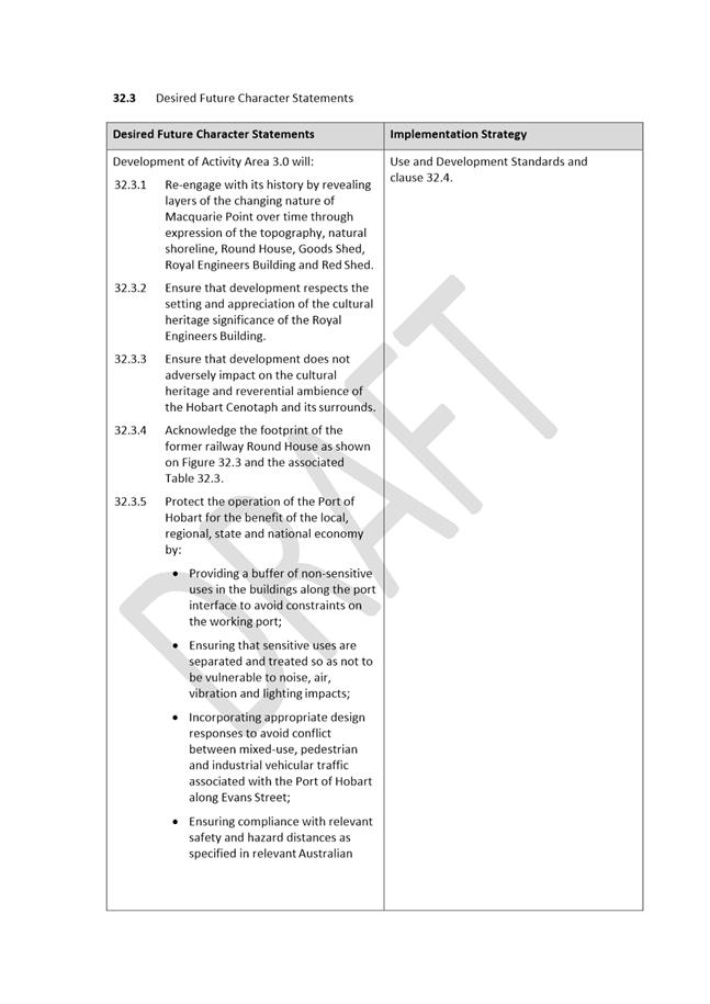
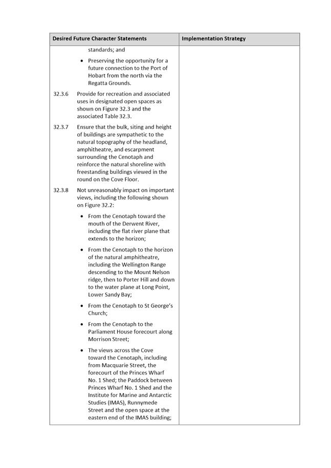
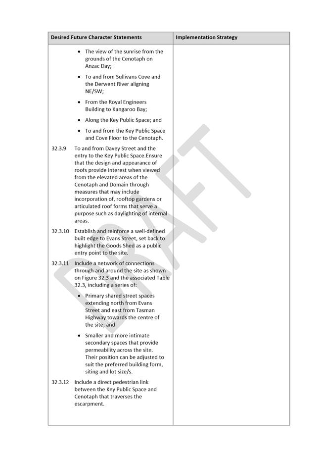
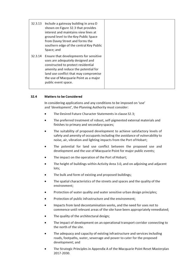
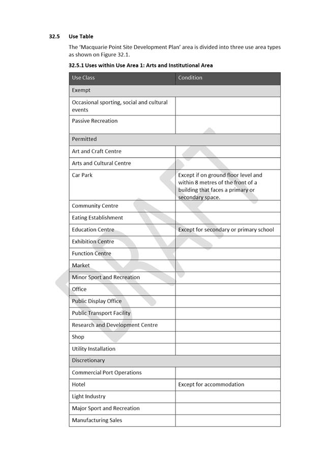
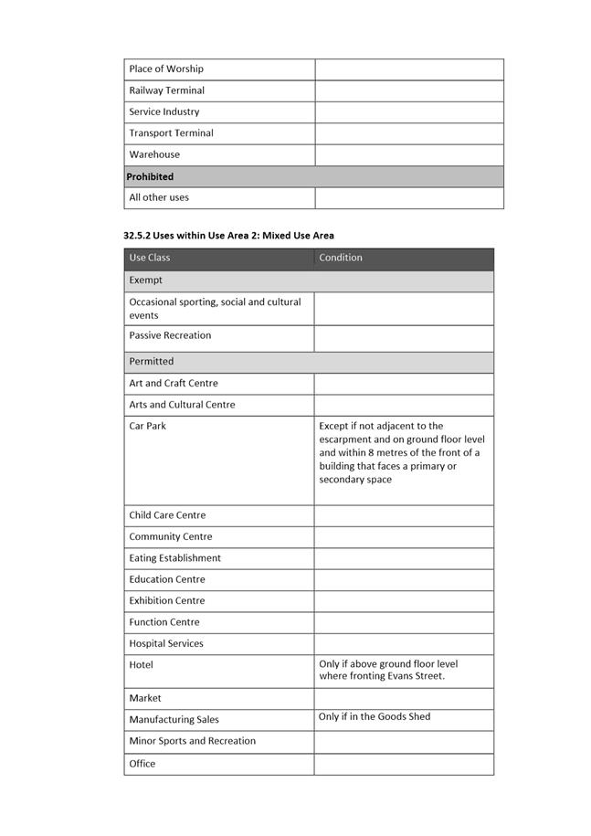
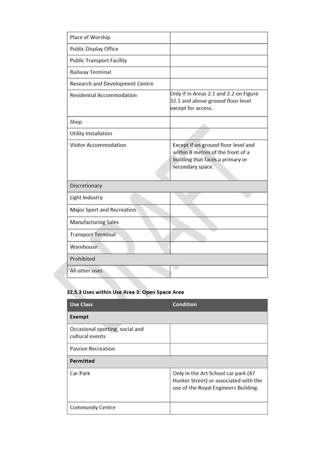
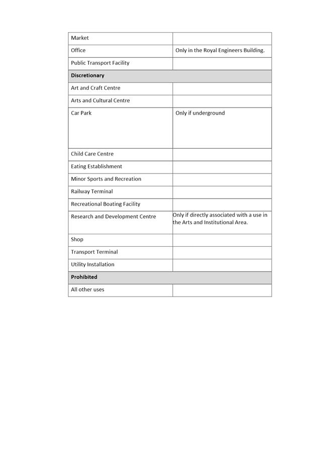
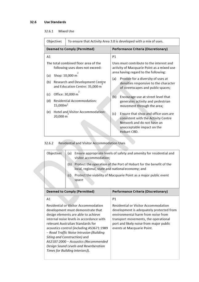
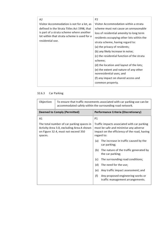
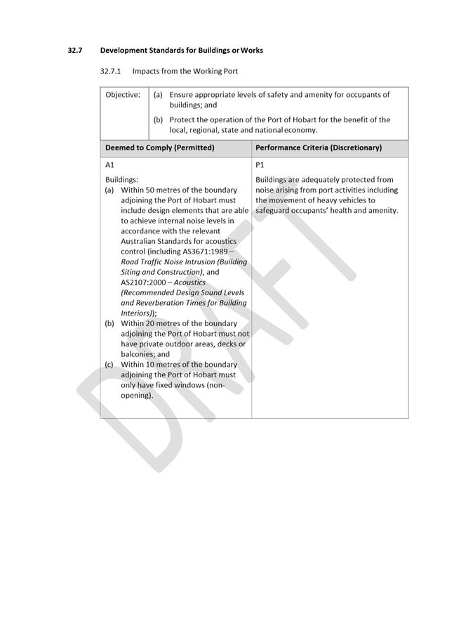
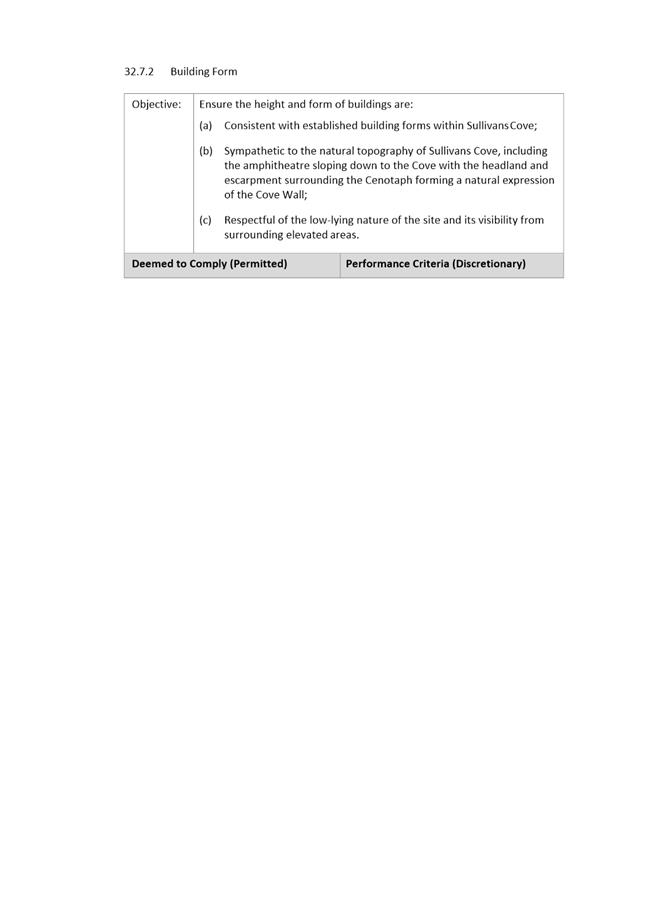
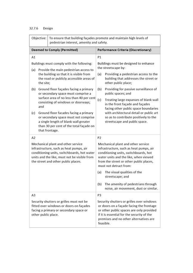
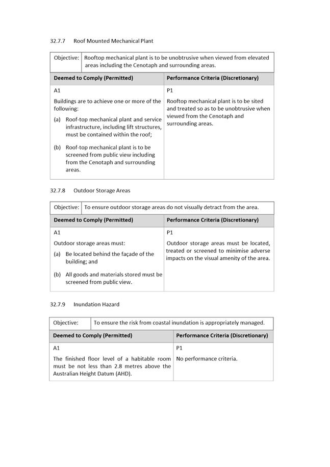
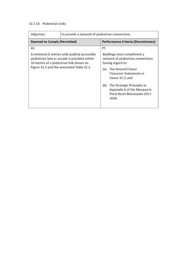
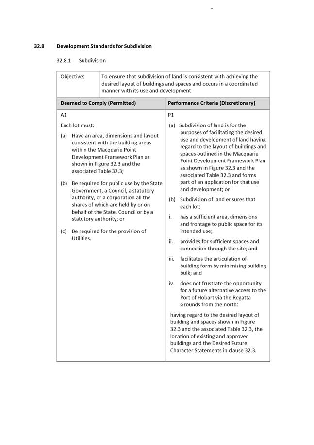
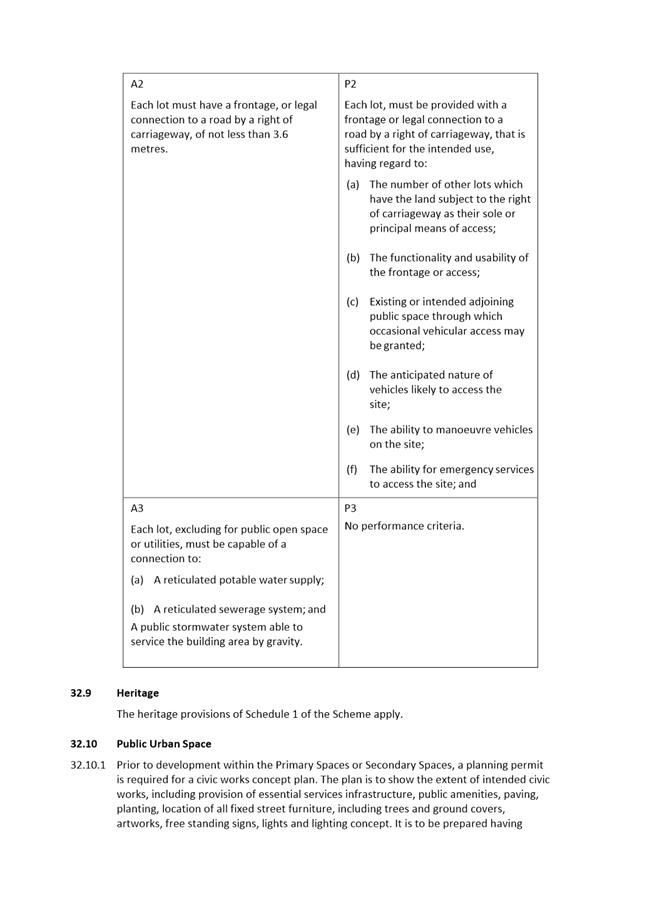
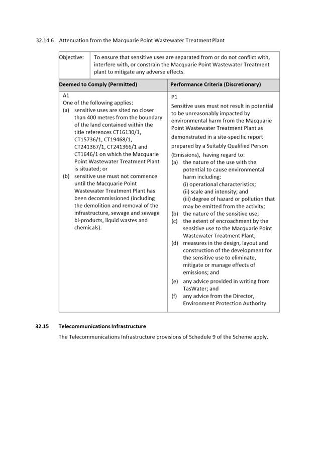
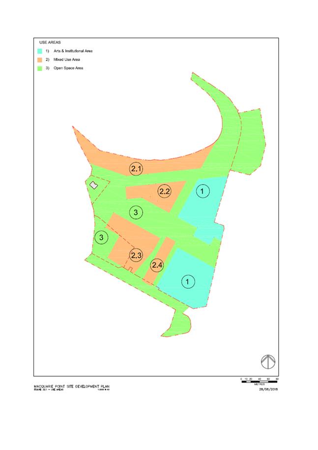
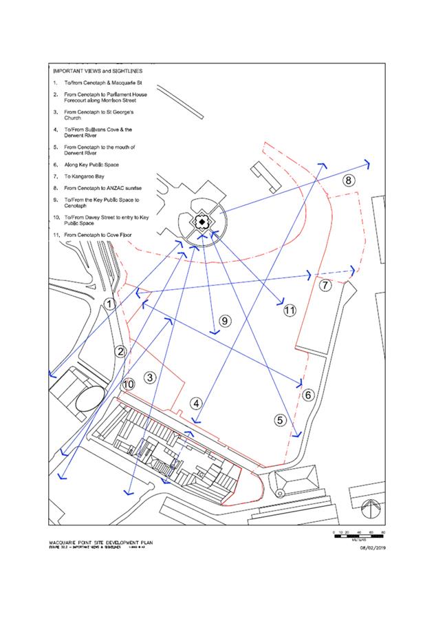
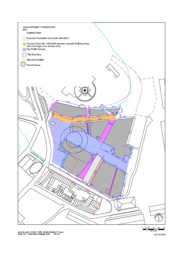
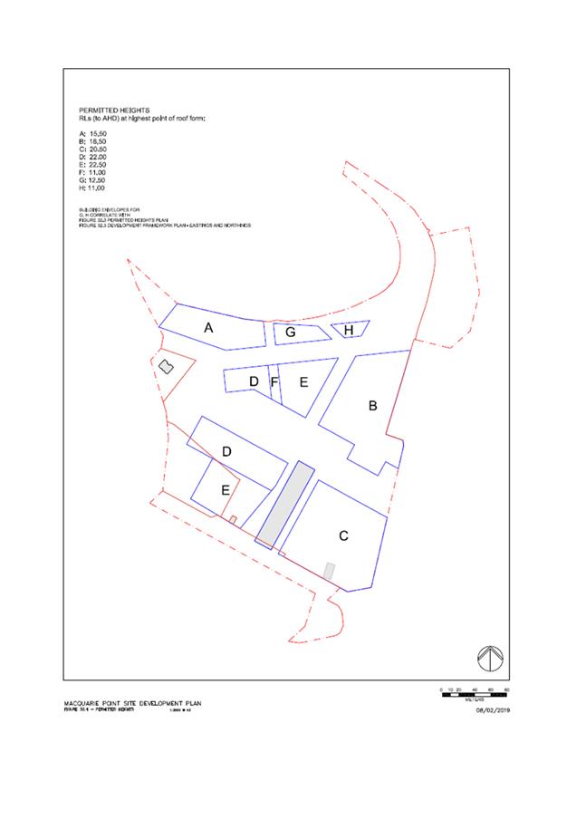
|
Agenda (Open Portion) City Planning Committee Meeting - 27/5/2019 |
Page 163 ATTACHMENT c |
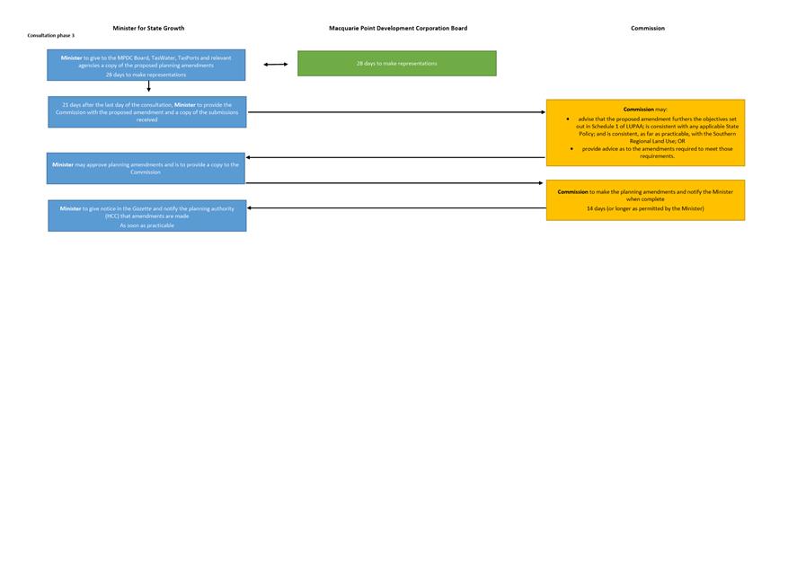
|
Agenda (Open Portion) City Planning Committee Meeting - 27/5/2019 |
Page 166 ATTACHMENT d |
|
Agenda (Open Portion) City Planning Committee Meeting - 27/5/2019 |
Page 176 ATTACHMENT e |
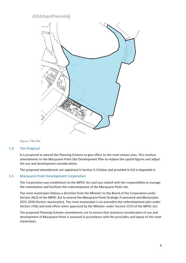
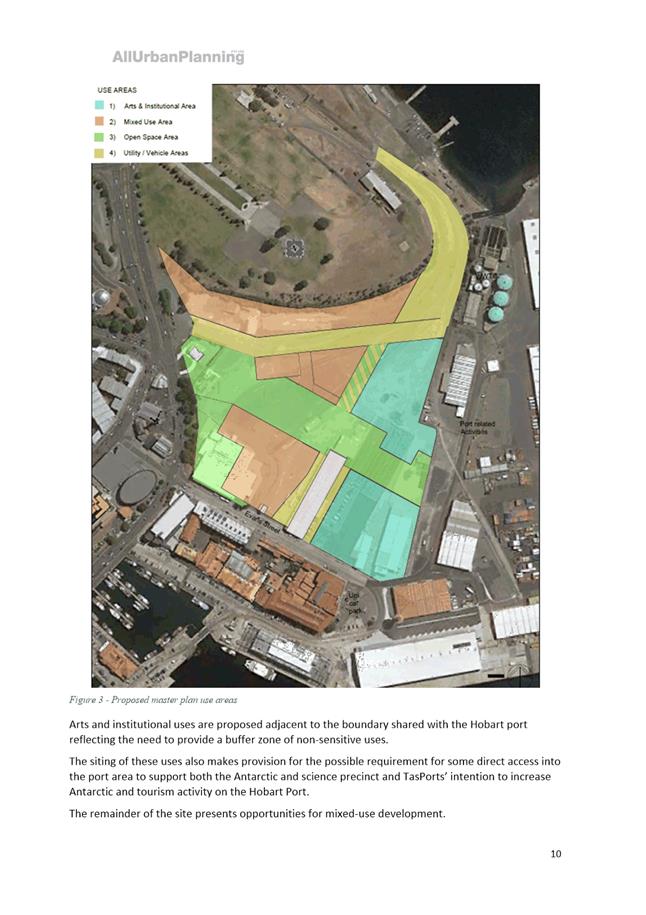
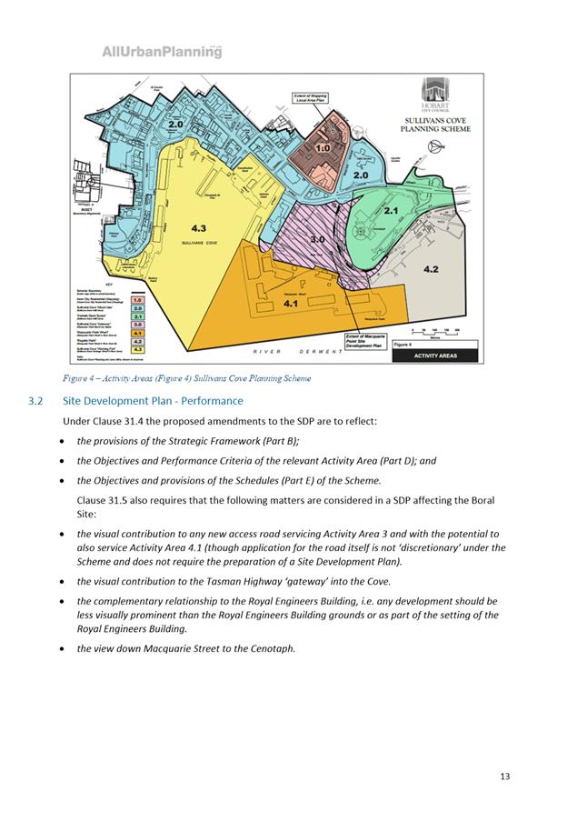
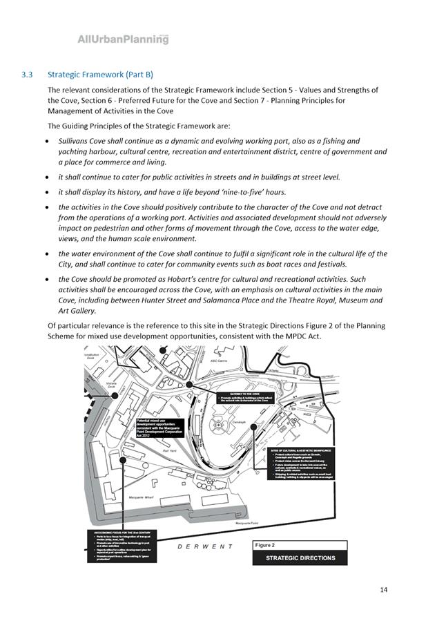
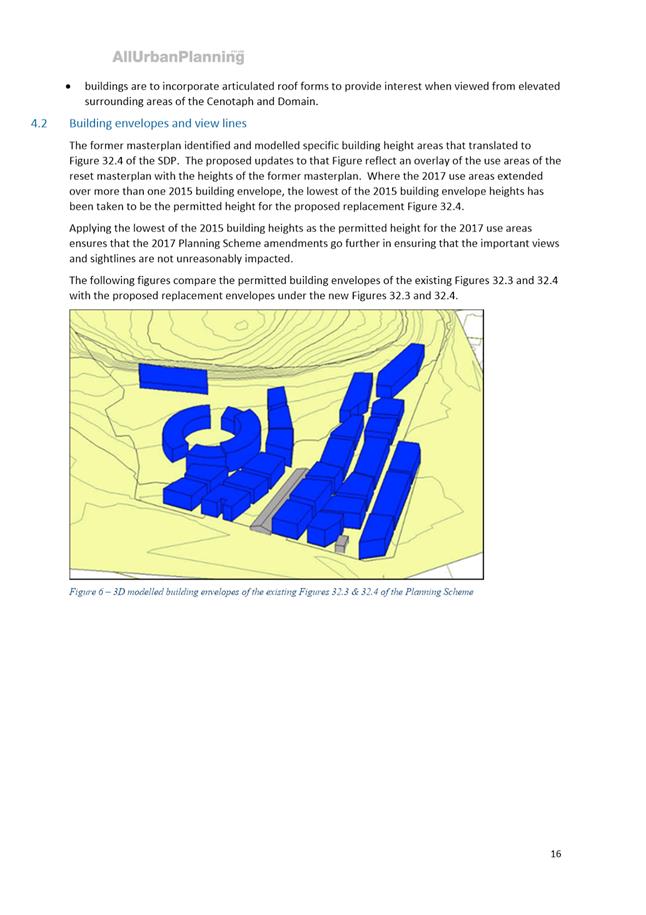
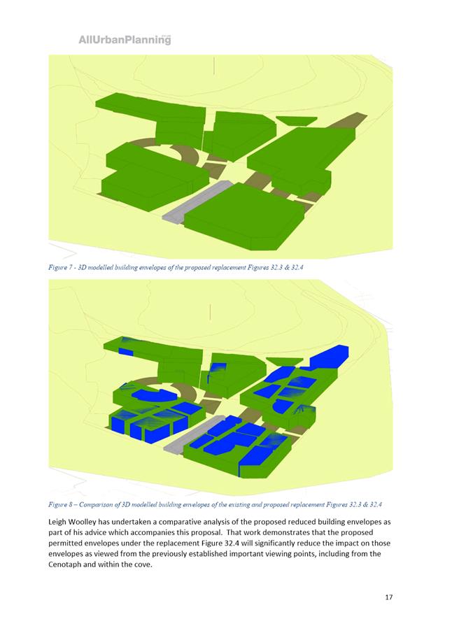
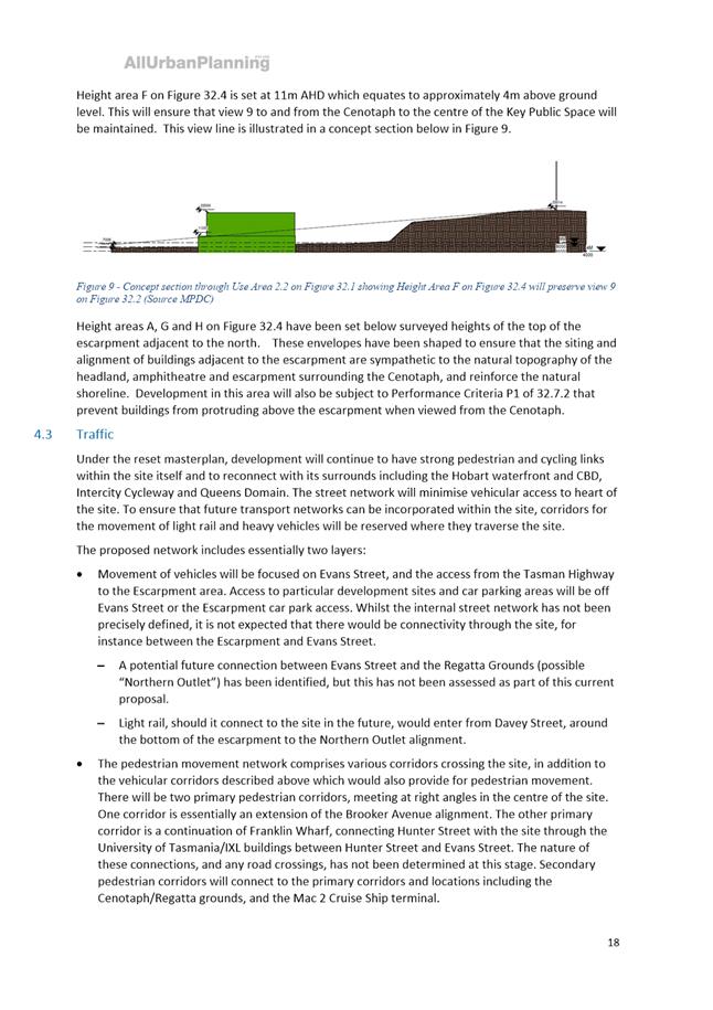
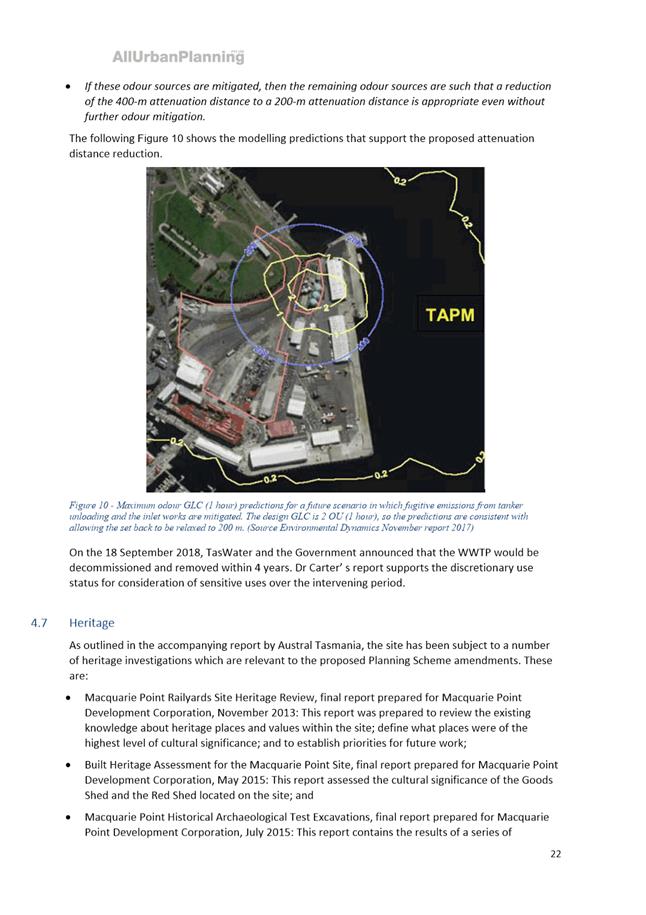
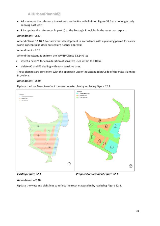
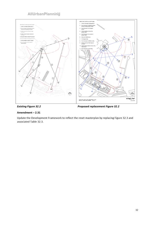
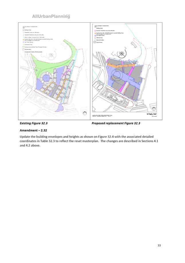
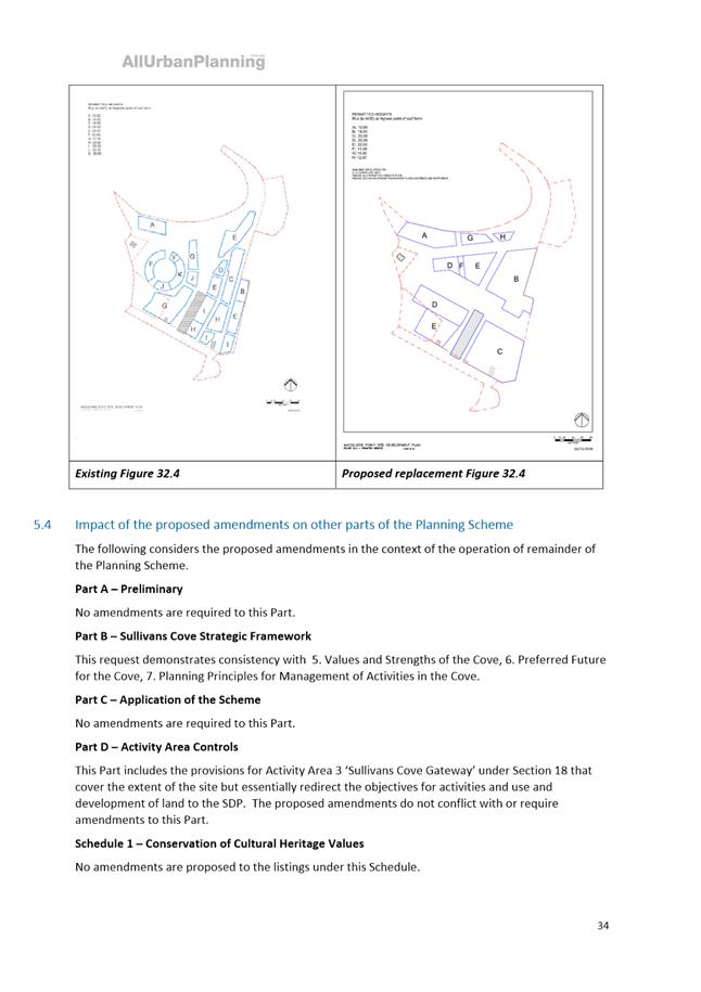
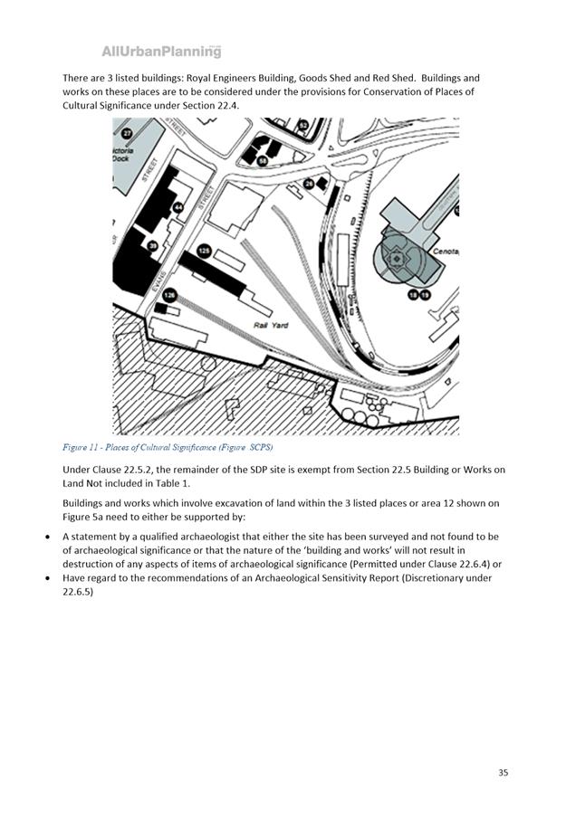
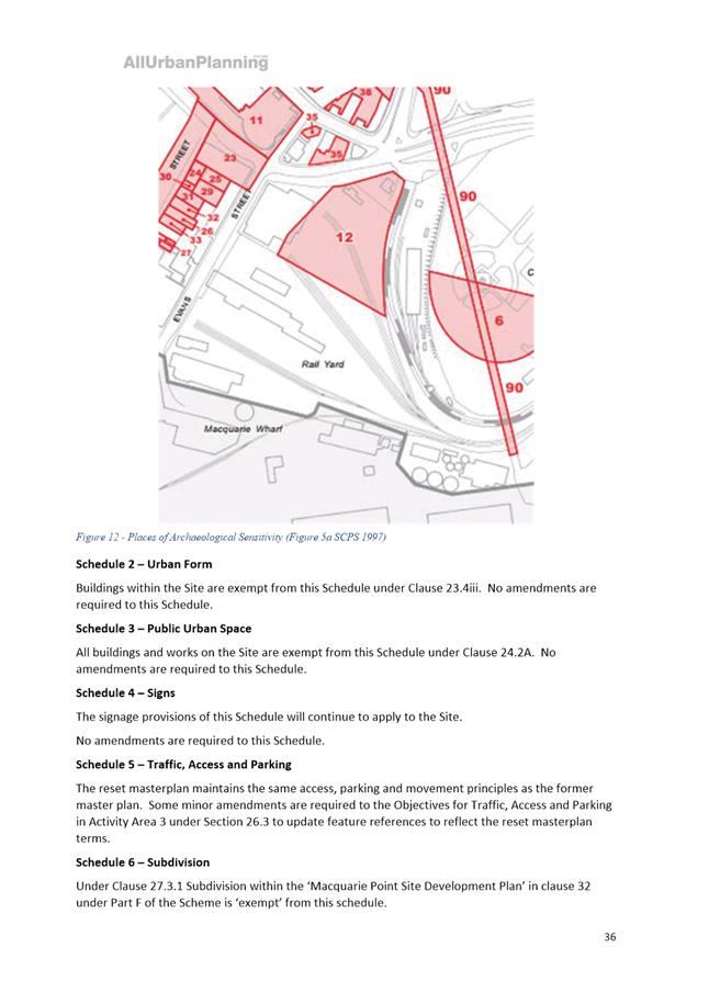
|
Agenda (Open Portion) City Planning Committee Meeting |
Page 223 |
|
|
|
27/5/2019 |
|
Report of the Manager Environmental Health of 22 May 2019 and attachments.
Delegation: Council
|
Item No. 8.2 |
Agenda (Open Portion) City Planning Committee Meeting |
Page 224 |
|
|
27/5/2019 |
|
REPORT TITLE: Beach Water Quality
REPORT PROVIDED BY: Manager Environmental Health
1. Report Purpose and Community Benefit
1.1. This report provides a summary of Councils recreational water quality sampling program undertaken over the 2018-19 summer season. Water samples were collected weekly from four swimming sites along the Hobart coastline between 1 December 2018 and 31 March 2019 as part of the Derwent Estuary Program (DEP) which is a joint initiative of the six local councils that border the estuary, and the State Government.
1.2. There was significant media attention on the program this year due to elevated results experienced at some sites along the estuary, in particular a number of sites in the Kingborough and Clarence municipalities.
1.3. The community benefit of the recommendations is to ensure the community continues to receive information on water quality data which provides guidance on public health risks of swimming sites, and the Council continues to demonstrate a commitment to ongoing improvement in recreational water quality through collaborative approaches to stormwater and wastewater management.
2. Report Summary
2.1. The Recreational Water Quality Guidelines issued under the Public Health Act 1997 require Councils to monitor the quality of recreational waters within their municipal area. Council’s role is to provide timely public health advice in relation to the water quality at recreational sites, which can vary from week to week.
2.2. Swimming sites sampled by Councils Environmental Health Officers are Little Sandy Bay and Nutgrove Beach. Environmental samples are also collected at Marieville Esplanade and Cornelian Bay.
2.3. During the season sanitary surveys and resampling are undertaken where sampling results exceed 140 MPN/100ml. Where consecutive samples both exceed 280 MPN/100ml the beach must be closed to swimming. Council has not needed to close a beach for many seasons.
2.4. Hobart’s sites showed mixed results this season with an improvement at the western end of Nutgrove Beach, and a decline at the eastern sampling site near the point adjacent to the sailing club. Little Sandy Bay has shown good water quality for many seasons and currently poses no cause for concern.
2.5. The improvement in results for Nutgrove Beach West has resulted in a reclassification from ‘Poor’ to ‘Fair’ is a significant achievement given this end of the beach has been classified as ‘Poor’ for over 10 years.
2.6. Nutgrove Beach East, which has shown good results in recent years and is the more popular end of the beach with primary and secondary contact users, has unfortunately declined from ‘Good’ back to ‘Fair’ and will now be a focal point for future actions to improve water quality.
|
That: 1. The Council issue a joint media release with the Derwent Estuary Program and TasWater to celebrate the improvement in water quality at Nutgrove Beach West drawing attention to the collaborative work on the Lipscombe Rivulet. 2. In conjunction with the Derwent Estuary Program and TasWater, Council undertakes an investigation and targeted sampling of potential stormwater related sources of contamination impacting Nutgrove Beach East prior to the commencement of the 2019-20 swimming and monitoring season. 3. Council implements the various activities as outlined within 5.1 of the report prior to the commencement of the season, and participates in workshops and training on methods for effective enterococci source tracing facilitated by the Derwent Estuary program. |
4. Background
4.1. The Recreational Water Quality Guidelines issued under the Public Health Act 1997 require Councils to monitor the quality of recreational waters within their municipal area. Council’s role is to provide timely public health advice in relation to the water quality at recreational sites, which can vary from week to week.
4.2. The City has been part of the Derwent Estuary Program (DEP) Beach Watch water sampling program for 20 years. This program collates all of the data from weekly sampling sites across the estuary over the period December to March each year. All results are published on the DEP Beach Watch website on a weekly basis, expressed as enterococci Most Probable Number (MPN) per 100ml.
4.3. Swimming sites sampled by Councils Environmental Health Officers are Little Sandy Bay and Nutgrove Beach. Environmental samples are also collected at Marieville Esplanade and Cornelian Bay.
4.4. The data informs a long-term water quality classification system for the beaches from ‘Poor’ through ‘Fair’ to ‘Good’. This system is based on the national guidelines and a rolling 5-year 95th Hazen percentile value of;
· <200 enterococci MPN/100ml = GOOD
· 200-500 enterococci MPN/100ml = FAIR
· >500 enterococci MPN/100ml = POOR
4.5. The 95th Hazen percentile is a recognised method which indicates that 95% of the enterococci results for the previous 5yr period are under the percentile. This excludes the 3 highest results from the data to give a more accurate picture of the water quality at the site over time.
4.6. During the season sanitary surveys and resampling are undertaken where sampling results exceed 140 MPN/100ml. Where consecutive samples both exceed 280 MPN/100ml the beach must be closed to swimming until further resamples indicate the threat has passed. Clearance to reopen a beach is given in conjunction with the Director of Public Health. Council has not needed to close a beach for many seasons.
4.7. At the commencement of the most recent season, Council beaches were classified as follows;
· Little Sandy Bay South GOOD (55 Hazen percentile)
· Little Sandy Bay North GOOD (118 Hazen percentile)
· Nutgrove Beach East GOOD (132 Hazen percentile)
· Nutgrove Beach West POOR (502 Hazen percentile)
4.8. The DEP’s Recreational Water Quality Program Annual Report for 2018-19, the public release of which is imminent, outlines the fact that water quality at swimming sites across the estuary in general showed an overall decline. Exceedances of the 140 MPN/100ml across the estuary more than doubled that recorded last season. Preliminary analysis of the season’s results by the DEP indicates an estuary-wide correlation of failed results to rainfall events. A copy of this report will be circulated to elected members upon release.
4.9. Hobart’s sites showed mixed results with an improvement at the western end of Nutgrove Beach, and a decline at the eastern sampling site near the point. Little Sandy Bay has shown good water quality for many seasons and currently poses no cause for concern. The new classifications are as follows;
· Little Sandy Bay South GOOD (54 Hazen percentile)
· Little Sandy Bay North GOOD (117 Hazen percentile)
· Nutgrove Beach East FAIR (220 Hazen percentile)
· Nutgrove Beach West FAIR (439 Hazen percentile)
4.10. The improvement in results for Nutgrove Beach West and the reclassification from ‘Poor’ to ‘Fair’ is a significant achievement given this end of the beach has been classified as ‘Poor’ for over 10 years.
4.11. The Council has an established track record of works and investigations into stormwater as guided by the current Stormwater Strategy 2012-2017.
4.12. During the summers of 16-17 and 17-18, TasWater, the Council and the DEP undertook a collaborative project on the Lipscombe Rivulet which discharges nearby this sampling site. The investigation resulted in the identification and rectification of sources of stormwater contamination. This type of focused work is resource intensive but has the potential to deliver real water quality improvements at end of pipe.
4.13. Nutgrove Beach East, which has shown good results in recent years, and is the more popular end of the beach with swimmers, has unfortunately declined from ‘Good’ back to ‘Fair’ and will now be a focal point for future actions to improve water quality. A graph of the Hazen percentile fluctuations for Nutgrove Beach East over the last 10 years is provided as Attachment A.
4.14. At a meeting of DEP stakeholders held on the 15th of May the season findings were reviewed and a variety of ideas discussed in relation to next season. It was clear from the discussion that there are different issues and no one remedy for all Councils managing water quality across the estuary. All agencies agreed to work together on various projects as determined.
5. Proposal and Implementation
5.1. It is proposed that Council undertakes the following activities in response to the season findings and ahead of the commencement of the next swimming season in December 2019;
5.1.1. Issue a joint media statement with the DEP and TasWater to highlight and celebrate the improved result for Nutgrove Beach West. It is highly likely that the collaborative work done on Lipscombe Rivulet has contributed to this improvement.
5.1.2. In conjunction with the DEP and TasWater, plan and undertake an investigation and targeted sampling of potential stormwater related sources of contamination impacting the coastline more directly in the vicinity of Nutgrove Beach East.
5.1.2.1. This investigation may be able to use more sophisticated sampling and contaminant detection methods such as in situ ATP testing which can measure live organisms through detection of adenosine triphosphate.
5.1.2.2. Both the Environmental Health and Environmental Engineering Unit will contribute resources to the project.
5.1.3. Upgrade signage along Nutgrove Beach with respect to the new classifications, and review sampling locations to confirm their relevance as swimming sites and make adjustments as necessary.
5.1.4. Adopt the improved response protocols for failed samples for next season including improved communications and greater use of sanitary surveys to assist in determination of potential sources of pollution. The sanitary survey from the Recreational Water Quality Guidelines is included for information as Attachment B.
5.1.5. Participate in the next DEP run inter-calibration sampling exercise to ensure consistency of sampling methods prior to the commencement of next season.
5.2. The DEP’s Recreational Water Quality Program Annual Report for 2018-19 also includes a summary of sampling undertaken at the environmental sites. It is noted that Waterman’s Dock made a significant improvement from ‘Poor’ to ‘Good’. The DEP will continue to provide scientific support to Councils during the winter period and in particular in relation to any specific investigations.
5.3. The DEP will coordinate a working group to develop a framework for how to effectively investigate sources of high enterococci and attempt to identify a threshold enterococci level for stormwater outfall discharge to beaches.
5.4. The Environment Protection Authority (EPA) will investigate recreational vessel and cruise ship impact on the estuary through an audit of facilities available for wastewater disposal and plans for upgrades as a basis for further discussion on these matters. The EPA will also make specialist staff available for data analysis and advice particularly around DNA and other methods of source identification testing where required.
5.5. TasWater will continue to report to council any sewer spills that affect recreational waters during the season as per the EPA Sewage Spill Notification Guidelines. TasWater will also continue to collaborate with Council’s on stormwater investigations.
5.6. The Department of Health will shortly be releasing their annual recreational water quality report for the 2017-18 financial year which will provide a summary of the quality of recreational waters statewide and recommendations for further work in some council areas.
6. Strategic Planning and Policy Considerations
6.1. The Council is required under the Public Health Act 1997 to monitor the quality of recreational waters within its municipal area, and this along with the investigation of potential sources of pollution contributes to the following strategic objectives of the Capital City Strategic Plan;
6.1.1. 3.2 Strong environmental stewardship, and
6.1.2. 4.3 Build community resilience, public health and safety.
7. Financial Implications
7.1. Funding Source and Impact on Current Year Operating Result
7.1.1. There will be no impact on the budget of the current year.
7.2. Impact on Future Years’ Financial Result
7.2.1. Funding has already been allocated within the Environmental Health Unit budget for recreational water sampling resource and analysis costs for the 2019-20 financial year.
7.2.2. It is anticipated that any additional costs associated with the on-ground work for the proposed Nutgrove Beach East investigation will be able to be absorbed by the Environmental Engineering Unit.
8. Legal, Risk and Legislative Considerations
8.1. The Council is required under section 130 of the Public Health Act 1997, to ‘monitor the quality of water within its municipal area in accordance with any relevant guidelines’. The Recreational Water Quality Guidelines 2007 specify the requirements for monitoring natural recreational waters and public swimming and spa pools with the aim being to prevent the incidence of disease during human contact with such waters. Water quality reports must be presented to the Director of Public Health by 30 September each year.
9. Environmental Considerations
9.1. The proposal to investigate stormwater and sewage impacts on Nutgrove Beach East aims to result in improved water quality for this urban swimming beach.
9.2. It is acknowledged that water quality issues are rarely linked to a single identified source, however, it is hoped that a focus on the most likely sources of contamination will lead to identification and remediation of issues.
10. Social and Customer Considerations
10.1. Recreational beaches are open to everyone and each member of the community should be able to make an informed choice with respect to whether or not they swim in these waters. The public is used to being able to check the website or make a phone call to ask about water quality and about what projects may be underway to address issues and concerns along the estuary.
11. Marketing and Media
11.1. It is envisaged that Councils media team will work with the DEP and TasWater to prepare and release suitable communications in respect of the positive reclassification of Nutgrove Beach West.
11.2. The Nutgrove Beach East project is to be reported upon as necessary in the future.
11.3. The DEP maintains the ‘Beachwatch’ website providing publically accessible up to date information on water quality along the whole estuary. The City may use its social media outlets including Facebook and the website to draw attention to poor water quality and make swimming recommendations in addition to physical signage.
12. Community and Stakeholder Engagement
12.1. Consultation has been undertaken with the DEP, EPA, TasWater and the Manager Road & Environmental Engineering. Due to the Councils participation in the Beach Watch program, relevant stakeholders are often in communication with each other and sharing ideas for projects and investigations to achieve positive environmental outcomes.
As signatory to this report, I certify that, pursuant to Section 55(1) of the Local Government Act 1993, I hold no interest, as referred to in Section 49 of the Local Government Act 1993, in matters contained in this report.
|
Felicity Edwards Manager Environmental Health |
|
Date: 22 May 2019
File Reference: F19/53845; 16/239
Attachment a: Nutgrove
Beach East Hazen 10yrs ⇩ ![]()
Attachment
b: Sanitary
Survey ⇩ ![]()
|
Item No. 8.2 |
Agenda (Open Portion) City Planning Committee Meeting - 27/5/2019 |
Page 231 ATTACHMENT a |
|
Agenda (Open Portion) City Planning Committee Meeting - 27/5/2019 |
Page 232 ATTACHMENT b |
|
Agenda (Open Portion) City Planning Committee Meeting |
Page 234 |
|
|
|
27/5/2019 |
|
8.3 Delegated Decisions Report (Planning)
Memorandum of the Director City Planning of 22 May 2019 and attachment.
Delegation: Committee
|
Item No. 8.3 |
Agenda (Open Portion) City Planning Committee Meeting |
Page 235 |
|
|
27/5/2019 |
|

Memorandum: City Planning Committee
Delegated Decisions Report (Planning)
Attached is the delegated planning decisions report for the period 7 May 2019 until 20 May 2019.
|
That the information contained in the memorandum titled ‘Delegated Decisions Report (Planning)’ of 22 May 2019 be received and noted.
|
As signatory to this report, I certify that, pursuant to Section 55(1) of the Local Government Act 1993, I hold no interest, as referred to in Section 49 of the Local Government Act 1993, in matters contained in this report.
|
Neil Noye Director City Planning |
|
Date: 22 May 2019
File Reference: F19/58584
Attachment a: Delegated
Decisions Report (Planning) ⇩ ![]()
|
Item No. 8.3 |
Agenda (Open Portion) City Planning Committee Meeting - 27/5/2019 |
Page 236 ATTACHMENT a |
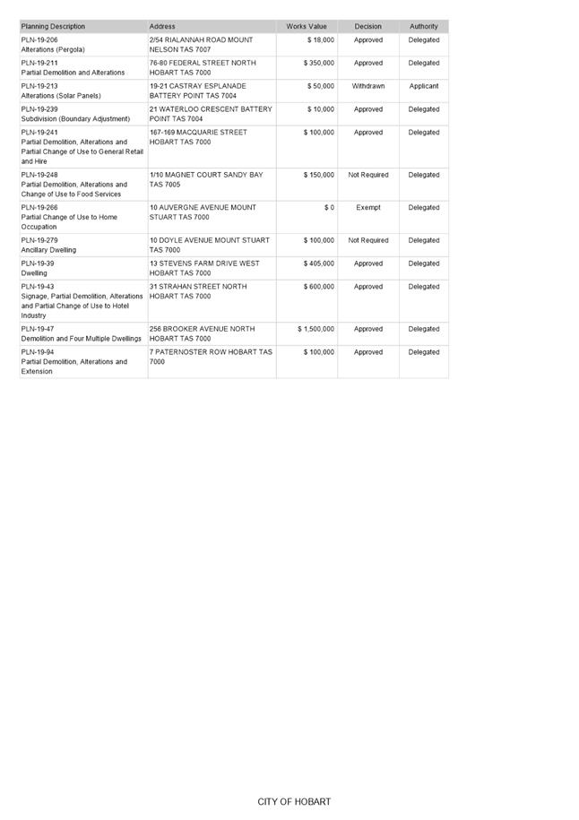
|
Agenda (Open Portion) City Planning Committee Meeting |
Page 238 |
|
|
|
27/5/2019 |
|
8.4 City Planning Advertising Report
Memorandum of the Director City Planning of 22 May 2019 and attachment.
Delegation: Committee
|
Item No. 8.4 |
Agenda (Open Portion) City Planning Committee Meeting |
Page 239 |
|
|
27/5/2019 |
|
Memorandum: City Planning Committee
City Planning Advertising Report
Attached is the advertising list for the period 7 May 2019 – 17 May 2019.
|
That the information contained in the memorandum titled ‘City Planning - Advertising Report’ of 22 May 2019 be received and noted.
|
As signatory to this report, I certify that, pursuant to Section 55(1) of the Local Government Act 1993, I hold no interest, as referred to in Section 49 of the Local Government Act 1993, in matters contained in this report.
|
Neil Noye Director City Planning |
|
Date: 22 May 2019
File Reference: F19/58359
Attachment a: City
Planning Advertising Report ⇩ ![]()
|
Item No. 8.4 |
Agenda (Open Portion) City Planning Committee Meeting - 27/5/2019 |
Page 240 ATTACHMENT a |
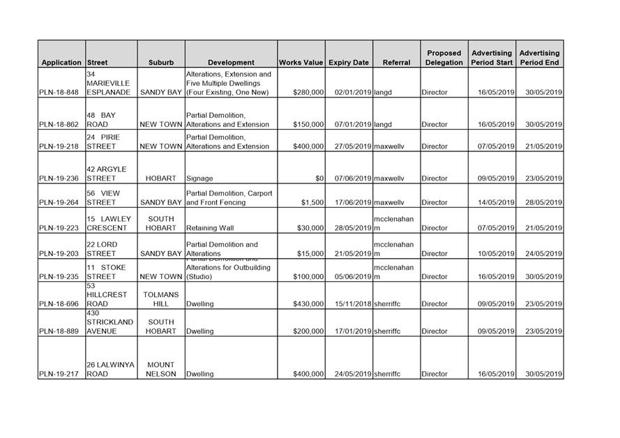
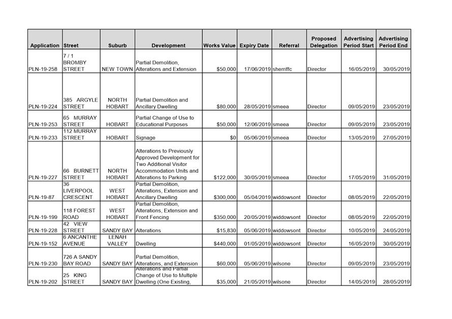
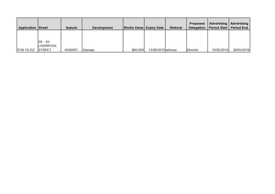
|
|
Agenda (Open Portion) City Planning Committee Meeting |
Page 245 |
|
|
27/5/2019 |
|
Section 29 of the Local Government (Meeting Procedures) Regulations 2015.
File Ref: 13-1-10
An Elected Member may ask a question without notice of the Chairman, another Elected Member, the General Manager or the General Manager’s representative, in line with the following procedures:
1. The Chairman will refuse to accept a question without notice if it does not relate to the Terms of Reference of the Council committee at which it is asked.
2. In putting a question without notice, an Elected Member must not:
(i) offer an argument or opinion; or
(ii) draw any inferences or make any imputations – except so far as may be necessary to explain the question.
3. The Chairman must not permit any debate of a question without notice or its answer.
4. The Chairman, Elected Member, General Manager or General Manager’s representative who is asked a question may decline to answer the question, if in the opinion of the respondent it is considered inappropriate due to its being unclear, insulting or improper.
5. The Chairman may require a question to be put in writing.
6. Where a question without notice is asked and answered at a meeting, both the question and the response will be recorded in the minutes of that meeting.
7. Where a response is not able to be provided at the meeting, the question will be taken on notice and
(i) the minutes of the meeting at which the question is asked will record the question and the fact that it has been taken on notice.
(ii) a written response will be provided to all Elected Members, at the appropriate time.
(iii) upon the answer to the question being circulated to Elected Members, both the question and the answer will be listed on the agenda for the next available ordinary meeting of the committee at which it was asked, where it will be listed for noting purposes only.
|
|
Agenda (Open Portion) City Planning Committee Meeting |
Page 246 |
|
|
27/5/2019 |
|