City
of hobart
AGENDA
City Infrastructure Committee Meeting
Open Portion
Thursday, 26 April 2018
at 5:00 pm
Lady Osborne Room, Town Hall
City
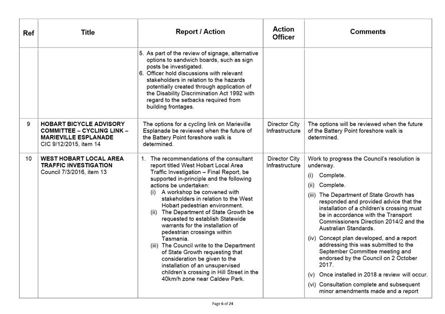
of hobart
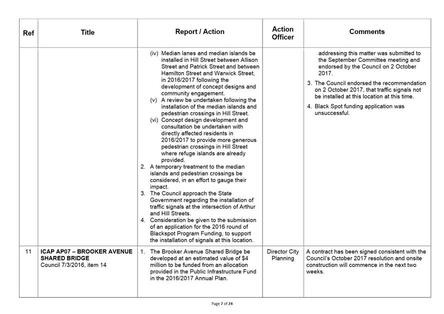
AGENDA
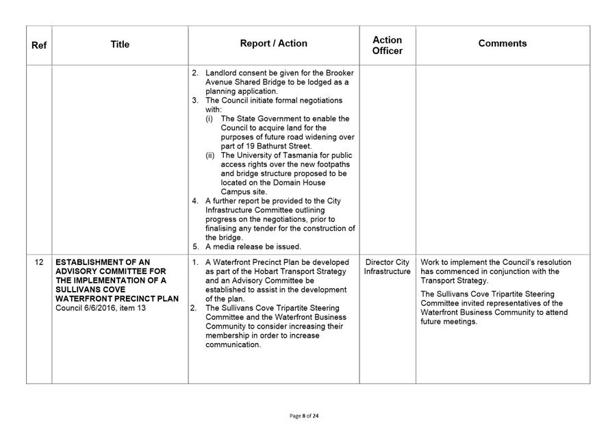
City Infrastructure Committee Meeting
Open Portion
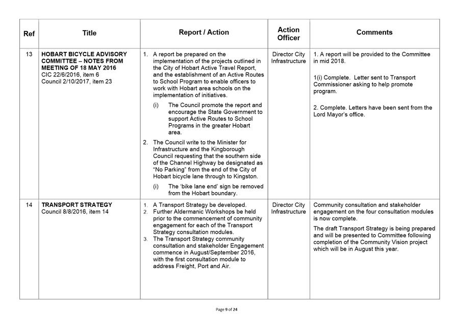
Thursday, 26 April 2018
at 5:00 pm
Lady Osborne Room, Town Hall
THE MISSION
Our mission is to ensure good governance of our capital City.
THE VALUES
The Council is:
|
about people |
We value people – our community, our customers and colleagues. |
|
professional |
We take pride in our work. |
|
enterprising |
We look for ways to create value. |
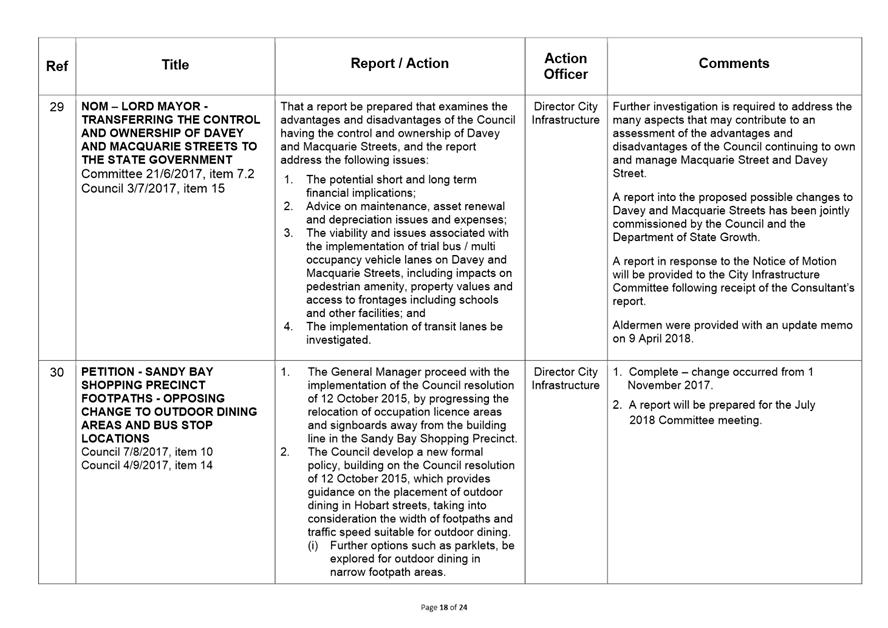
|
responsive |
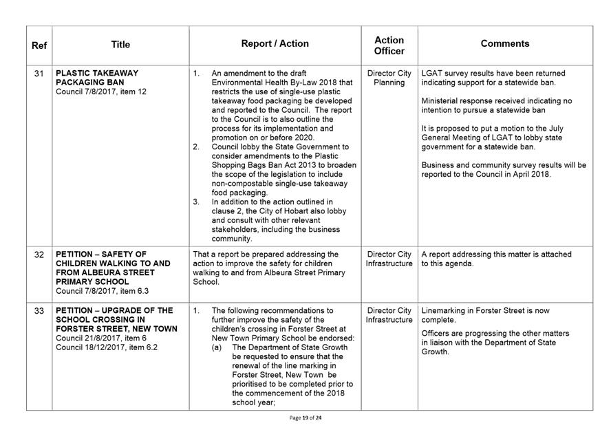
We’re accessible and focused on service. |
|
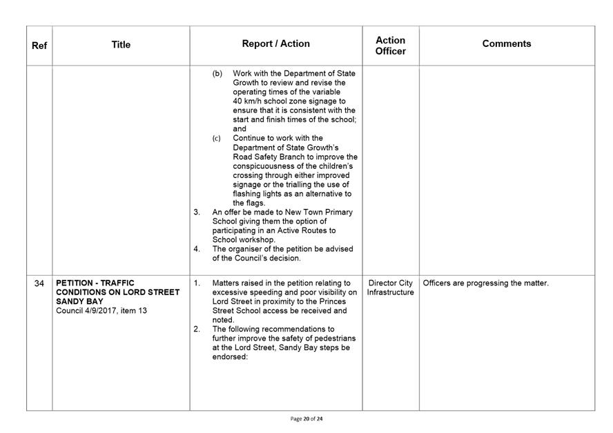
inclusive |
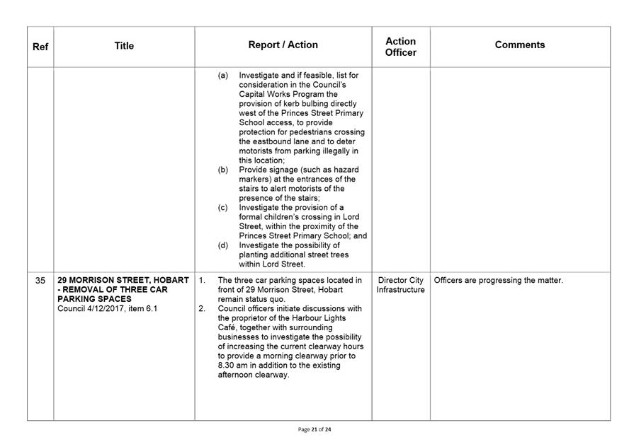
We respect diversity in people and ideas. |
|
making a difference |
We recognise that everything we do shapes Hobart’s future. |
Business listed on the agenda is to be conducted in the order in which it is set out, unless the committee by simple majority determines otherwise.
APOLOGIES AND LEAVE OF ABSENCE
1. Co-Option of a Committee Member in the event of a vacancy
3. Consideration of Supplementary Items
4. Indications of Pecuniary and Conflicts of Interest
6.1 McRobies Gully Waste Management Centre - Annual Performance Report
6.2 2018/2019 Fees and Charges - Parks and City Amenity Division - Cleansing and Solid Waste
6.3 2018/2019 Fees and Charges - City Infrastructure Division
6.4 Petition - Safety of Children Walking To and From Albeura Street Primary School
6.5 Petition - Pedestrian (Zebra) Crossing on Creek Road, Lenah Valley
6.7 Upper Domain Road – Road Closure – Review of Representations
6.8 Stormwater System - Capacity and Condition
6.9 Cycling South Meeting Minutes - 20 February 2018
7. Committee Action Status Report
7.1 Committee Actions - Status Report
9. Closed Portion Of The Meeting
City Infrastructure Committee Meeting (Open Portion) held Thursday, 26 April 2018 at 5:00 pm in the Lady Osborne Room, Town Hall.
|
COMMITTEE MEMBERS Burnet (Chairman) Lord Mayor Christie Reynolds Denison Harvey
ALDERMEN Deputy Lord Mayor Sexton Zucco Briscoe Ruzicka Cocker Thomas |
Apologies:
Leave of Absence: Nil.
|
|
The minutes of the Open Portion of the City Infrastructure Committee meeting held on Wednesday, 21 March 2018, are submitted for confirming as an accurate record.
|
Ref: Part 2, Regulation 8(6) of the Local Government (Meeting Procedures) Regulations 2015.
|
That the Committee resolve to deal with any supplementary items not appearing on the agenda, as reported by the General Manager.
|
Ref: Part 2, Regulation 8(7) of the Local Government (Meeting Procedures) Regulations 2015.
Aldermen are requested to indicate where they may have any pecuniary or conflict of interest in respect to any matter appearing on the agenda, or any supplementary item to the agenda, which the committee has resolved to deal with.
Regulation 15 of the Local Government (Meeting Procedures) Regulations 2015.
A committee may close a part of a meeting to the public where a matter to be discussed falls within 15(2) of the above regulations.
In the event that the committee transfer an item to the closed portion, the reasons for doing so should be stated.
Are there any items which should be transferred from this agenda to the closed portion of the agenda, or from the closed to the open portion of the agenda?
6.1 McRobies Gully Waste Management Centre - Annual Performance Report
Report of the Cleansing & Solid Waste Policy Coordinator, the Manager Cleansing and Solid Waste and the Director Parks and City Amenity of 18 April 2018 and attachment.
Delegation: Committee
REPORT TITLE: McRobies Gully Waste Management Centre - Annual Performance Report
REPORT PROVIDED BY: Cleansing & Solid Waste Policy Coordinator
Manager Cleansing and Solid Waste
Director Parks and City Amenity
1. Report Purpose and Community Benefit
1.1. The purpose of this report is to present the McRobies Gully Waste Management Centre Annual Performance Report.
1.2. The Annual Performance Report will benefit the community by providing a snapshot of the overall performance of the site.
2. Report Summary
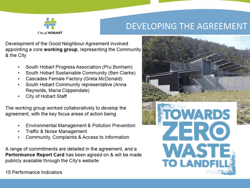
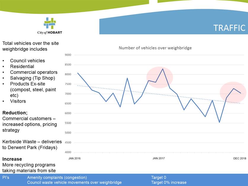
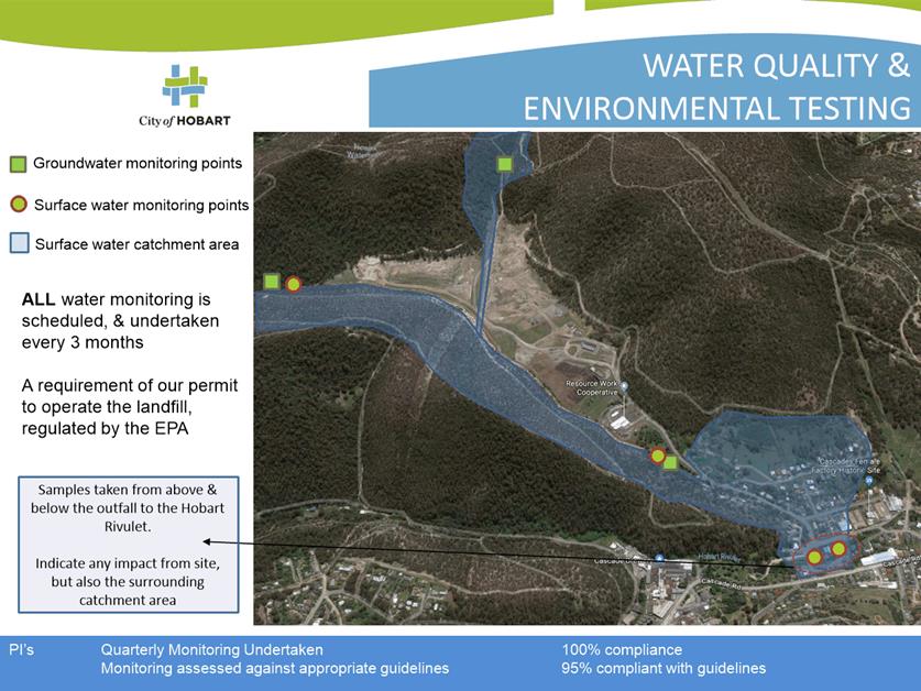
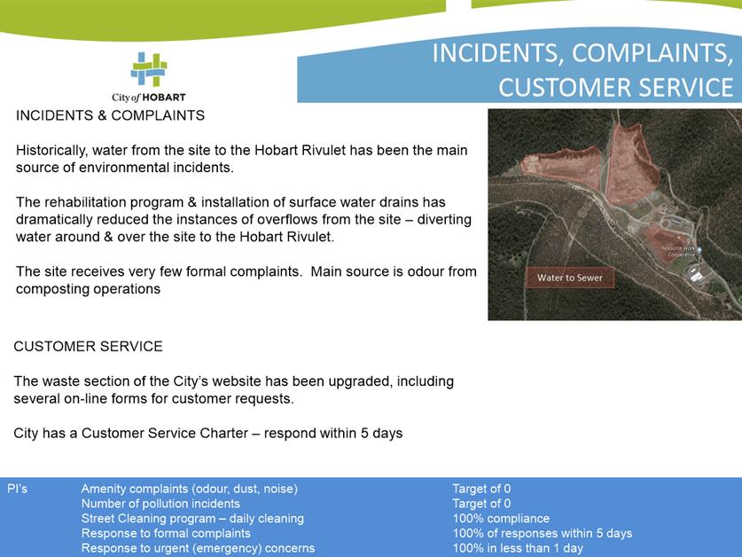
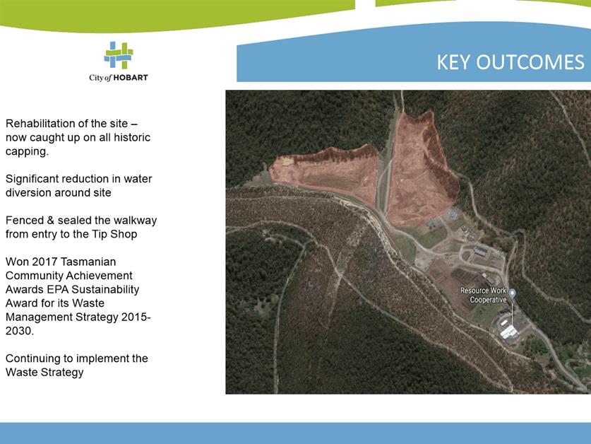
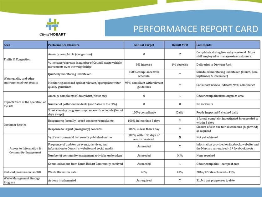
2.1. The City has developed an Annual Performance Report for the McRobies Gully Waste Management Centre (Attachment A). It contains 15 Performance Indicators across themes that are considered of particular interest to the South Hobart Community, including traffic, environmental performance, and provision of information.
2.2. The Performance Report has been developed as a component of the Good Neighbour Agreement. This agreement is managed by a working group comprising of representatives from the South Hobart community, the South Hobart Progress Association, South Hobart Sustainable Communities, and the Cascades Female Factory (Port Arthur Historic Sites).
2.3. The Performance Report for 2016/17, and the background to it was presented to the broader South Hobart Community at an open public information session on 4 April 2018.
2.4. It is intended to make the McRobies Gully Waste Management Centre Annual Performance Report publicly available through the City’s website, and also present it to the community annually at a public meeting.
|
That the McRobies Gully Waste Management Centre Annual Performance Report for 2016/17, marked as Attachment A to the report, be noted and made available on the City’s website. |
4. Background
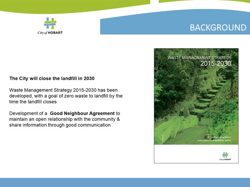
4.1. The City has committed to developing a Good Neighbour Agreement under the Waste Management Strategy 2015-2030 (Action 3.12). The Agreement was finalised in March 2017, and seeks to replicate being good residential neighbours, encouraging open communication and looking out for each other.
4.2. Under the Good Neighbour Agreement the City committed to undertaking a range of community consultation activities to keep the community informed of the operations at the site. The Annual Performance Report captures a lot of the information the City agreed to provide, and presents it in a succinct manner.
4.3. Much of the information within the Performance Report is already captured for reporting purposes, either internally or externally, such as annual reporting to the EPA under our Environment Protection Notice for the site, National Pollutant Inventory Reporting, and waste data reporting.
4.4. The Report was developed by the Good Neighbour Working Group, containing key representatives of the community. The group considered the report to cover of the essential indicators the community are keen be informed of.
4.5. A public information session was held at the Living Arts Centre on the 4 April 2018, to present the Report, take feedback on its content, and also to take any questions about the site.
4.6. Over 800 tenements in the immediate vicinity of the site were sent a letter advising of the session. Around 20 residents attended, indicating that the summary and session was appreciated, and that they would like to see future sessions. The main comments/questions raised by the community were regarding traffic, treatment of organic waste, odour & litter controls, and the future use(s) of the site.
5. Proposal and Implementation
5.1. It is proposed to complete the Annual Performance Report on a financial year basis, and make it available to the public once complete.
5.2. Data will be collated throughout the year and obtained from sources such as TRIM, the site weighbridge software, and environmental records.
6. Strategic Planning and Policy Considerations
6.1. The development and implementation of the Waste Management Strategy 2015-2030 is identified in the City’s Strategic Plan (3.2.5).
6.2. The development of the good Neighbour Agreement is detailed as Action 3.12 in the Waste Management Strategy 2015-2030. The strategy also contains numerous other actions in the key focus area of education and engagement.
7. Financial Implications
7.1. Funding Source and Impact on Current Year Operating Result
7.1.1. No Impact.
8. Legal, Risk and Legislative Considerations
8.1. The McRobies Gully Waste Management Centre operates under a permit issued by the Tasmanian State Government Environment Protection Agency.
8.2. The site also operates under an integrated Risk Management System (as per all other operations of the City) addressing Environment, Quality and Safety risks.
9. Environmental Considerations
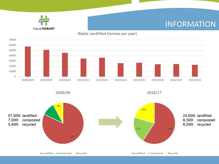
9.1. The Performance Report will convey details the site operations and waste minimisation and reduction programs to the broader community, highlighting positive contributions the City, its residents, and businesses are making towards zero waste to landfill.
10. Social and Customer Considerations
10.1. The McRobies Gully Waste Management Centre Annual Performance Report has been developed to improve the flow of information to the community and the sites customers.
10.2. Making this information publicly available and providing regular information sessions will help build a strong and open relationship between the site and its immediate community. It also promotes discussion in the waste field and aims to provide a more informed community, with those reading the report and attending sessions able to provide information back to others in the community.
10.3. Having key representatives from various community groups on the GNWG also extends the ability for information to be disseminated through their respective networks.
11. Marketing and Media
11.1. The Annual Performance Report will be made publicly available on the City’s website.
12. Delegation
12.1. The matter is for the Committee to note.
As signatory to this report, I certify that, pursuant to Section 55(1) of the Local Government Act 1993, I hold no interest, as referred to in Section 49 of the Local Government Act 1993, in matters contained in this report.
|
Jeff Holmes Cleansing & Solid Waste Policy Coordinator |
David Holman Manager Cleansing and Solid Waste |
|
Glenn Doyle Director Parks and City Amenity |
|
Date: 18 April 2018
File Reference: F18/31383; 2016-0192
Attachment a: Annual
Performance Report - April 2018 ⇩ ![]()
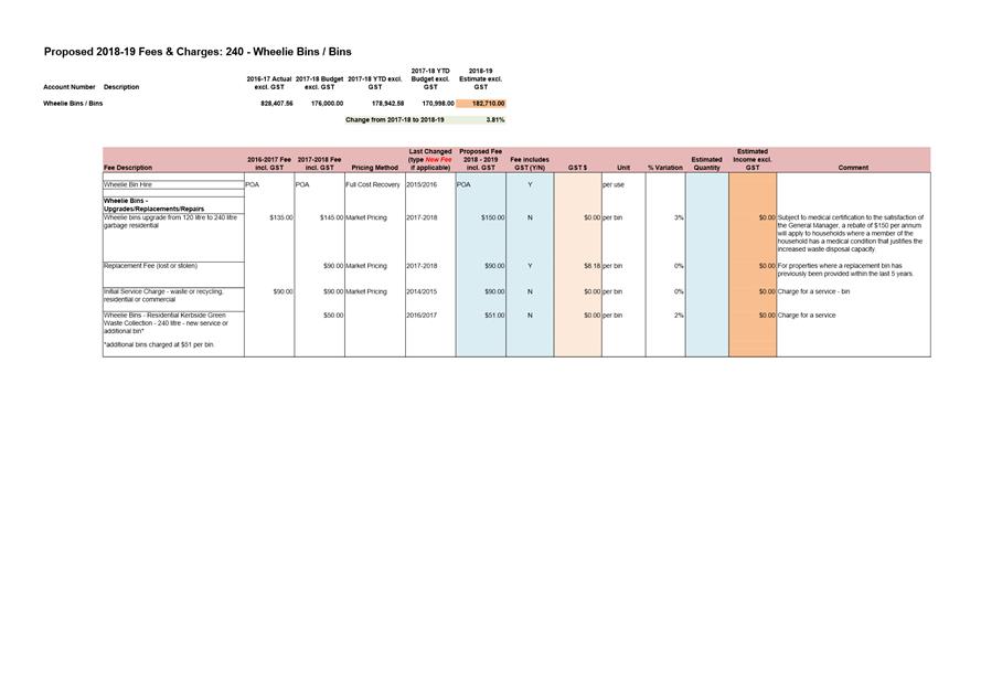
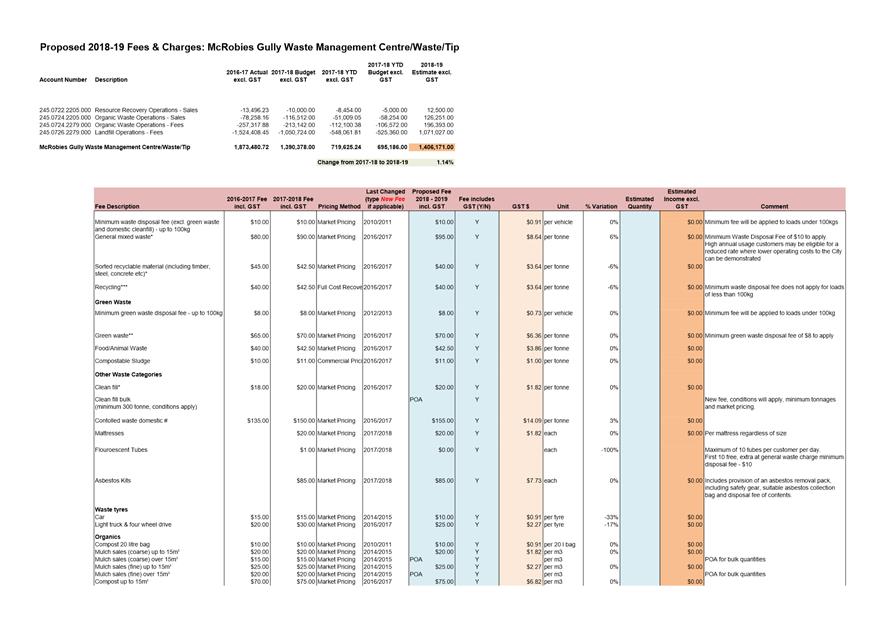
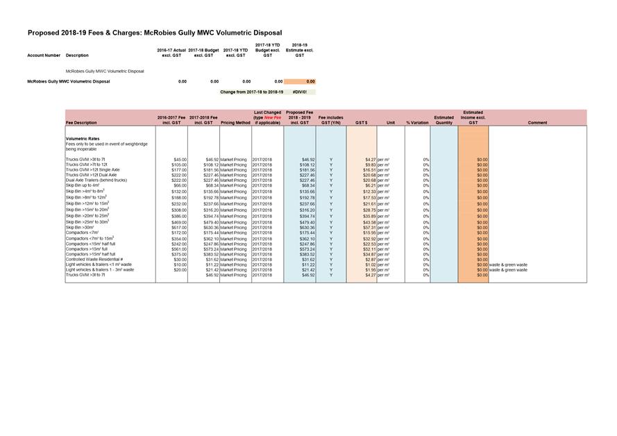
6.2 2018/2019 Fees and Charges - Parks and City Amenity Division - Cleansing and Solid Waste
Report of the Director Parks and City Amenity of 19 April 2018 and attachment.
Delegation: Council
REPORT TITLE: 2018/2019 Fees and Charges - Parks and City Amenity Division - Cleansing and Solid Waste
REPORT PROVIDED BY: Director Parks and City Amenity
1. Report Purpose and Community Benefit
1.1. The purpose of this report is to seek endorsement of the proposed fees and charges applicable to the Parks and City Amenity Division’s Cleansing and Solid Waste functions for the 2018-19 financial year to enable consideration by the Council, via the City Infrastructure Committee.
2. Report Summary
2.1. Pursuant to section 205 of the Local Government Act 1993, the Council may impose fees and charges for various services.
2.2. The attached schedules detail the proposed fees and charges for the following activities for the 2018-19 financial year:
2.2.1. Cleansing and Solid Waste (refer Attachment A).
|
That the attached schedules of fees and charges be endorsed for Cleansing and Solid Waste for the 2018/2019 financial year as marked as Attachments A to this report. |
4. Background
4.1. The fees and charges for the Parks and City Amenity’s Cleansing and Solid Waste Unit for the 2018-19 financial year have been assessed.
5. Proposal and Implementation
5.1. It is proposed that the attached schedules of fees and charges for the 2018-19 financial year be approved.
City Cleansing & Solid Waste Requested Works
5.2. Services will continue to be charged via quote or on a do-and-charge basis.
5.3. The City’s contracts with a small number of third parties to clean its public facilities has recently concluded, seeing a subsequent reduction in anticipated revenue for the business function, as such revenue is anticipated to decrease by $32,500 or -60%.
Wheelie Bins
5.4. Minor changes to fee is proposed with minor increase to revenue (due to increased number of houses) of $6,700 or 3.8% anticipated.
McRobies Gully Waste Management Centre
5.5. Minor changes to fees are proposed to further incentivise waste diversion from landfill, with minor increase to revenue of $15,800 or 1.14% anticipated.
5.6. The fee structure continues to support the goals of the City’s Waste Management Strategy 2015-2030 with the aim of having Zero Waste to Landfill by 2030.
6. Strategic Planning and Policy Considerations
6.1. The annual review of the City’s fees and charges contributes to the Capital City Strategic Plan 2015-2025 - Goal 5 – “Governance, Leadership provides for informed decision-making for our capital city”.
7. Financial Implications
7.1. Funding Source and Impact on Current Year Operating Result
7.1.1. Not applicable.
7.2. Impact on Future Years’ Financial Result
7.2.1. The review of the fees and charges for the Division’s Cleansing and Solid Waste Unit has been undertaken and expected increases/decreases for the 2018-19 financial year for each function area is expected as follows:
Function Area |
2017-18 |
2018-19 |
Increase / (Decrease) |
|
|
City Cleansing & Solid Waste Requested Works |
$59,530 |
$27,002 |
($32,528) |
(60.8%) |
|
Wheelie Bins |
$875,700 |
$882,400 |
$6,700 |
3.8% |
|
McRobies Gully Waste Management Centre |
$1.38M |
$1.395M |
$15,793 |
1.14% |
8. Legal, Risk and Legislative Considerations
8.1. Pursuant to section 205 of the Local Government Act 1993, the Council may impose fees and charges for various services.
9. Delegation
9.1. This matter is delegated to the Council.
As signatory to this report, I certify that, pursuant to Section 55(1) of the Local Government Act 1993, I hold no interest, as referred to in Section 49 of the Local Government Act 1993, in matters contained in this report.
|
Glenn Doyle Director Parks and City Amenity |
|
Date: 19 April 2018
File Reference: F18/31638
Attachment a: Proposed
Fees and Charges - Cleansing and Solid Waste ⇩ ![]()
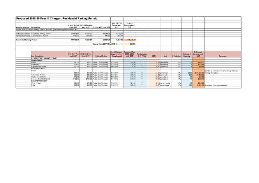
6.3 2018/2019 Fees and Charges - City Infrastructure Division
Report of the Director City Infrastructure of 19 April 2018 and attachment.
Delegation: Council
REPORT TITLE: 2018/2019 Fees and Charges - City Infrastructure Division
REPORT PROVIDED BY: Director City Infrastructure
1. Report Purpose and Community Benefit
1.1. In accordance with the requirements of Council Pricing Policy and Guidelines dated 29 January 2018, the Council is to review its fees and charges on an annual basis as part of the budget process.
1.2. The purpose of this report is to present the proposed schedule of fees and charges for the City Infrastructure Division for the 2018/2019 financial year for endorsement.
2. Report Summary
2.1. The attached fees and charges as summarised in Attachment A to this report outlines the present fees and charges for the City Infrastructure Division and the proposed fees and charges for the 2018/2019 financial year.
2.2. Where a fee increase is proposed, this is in order to more accurately reflect cost recovery and market pricing.
2.3. Four new fees have been proposed in the Traffic, Strategy and Project Function area and they are detailed in clause 5.6 below.
2.4. Projected income generated by the activities of the Division has been based on a conservative estimate of demand for these services. The income generated by the Division is in part due to the level of construction activity in the community.
2.5. The total income generated for 2018/2019 is estimated to be $365,555 which is a decrease of approximately 4% of the income estimated from the previous financial year.
|
That the attached schedules of fees and charges be endorsed for the City Infrastructure Division for the 2018/2019 financial year as marked as Attachments A to this report. |
4. Background
4.1. The attached fees and charges as summarised in Attachment A to this report outline the present fees and charges for the City Infrastructure Division and the proposed fees and charges for the 2018/2019 financial year.
4.1.1. Four new fees are proposed and no other significant fee increases are proposed.
4.1.2. The income projection for Civil Maintenance – Stormwater Service Connections has almost halved from $82,086 in 2017/2018 to $44,109 in 2018/2019, as it is anticipated that more of this work will be provided by private contractors who are directly engaged by developers.
4.2. The anticipated income generated by the activities of the Division has been based on a conservative estimate of demand for these services. The income generated by the Division is in part due to the level of construction activity in the community.
5. Proposal and Implementation
5.1. The following provides information in relation to the proposed services and associated fees and charges levied by the City Infrastructure Division within each program area.
5.1.1. Subject to Council approval, the fees and charges for the 2018/2019 financial year will become effective from 1 July 2018.
Residential Parking
5.2. No changes to the fees associated with residential parking permits are proposed for this year.
5.3. The income projection for the residential parking function, including parking exemption permits is approximately $116,348 which is approximately 33% of the Division’s anticipated income.
5.3.1. This figure has increased from 2017/2018 with an estimated increase in 800 residential parking permits to be issued in 2018/2019.
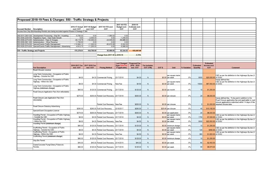
Traffic Strategy and Projects
5.4. These fees and charges relate to use of the road reservation to support construction activities in adjacent land or special events which are conducted in the road reserve.
5.5. It is expected that there will be a slight decrease in income compared to the 2017/2018 expected actuals for this budget function. The decrease in fees is to better reflect the cost to the Council and the impact that these activities have on the community.
5.6. There are also four (4) new fees proposed, as follows:
(i) Road Closure Licences for Long Term Construction (Occupation of the Public Highway within the CBD);
(ii) Road Closure Late Application Fee (non refundable) – to be paid in addition to the Road Closure application fee and applicable to road closure applications submitted within 14 days of the required closure date;
(iii) Hoarding Permit – Occupation of Public Highway within the CBD; and
(iv) Scaffolding Permit – Occupation of Public Highway within the CBD.
5.7. The income projection for this function is $155,307 which is approximately 42% of the Division’s anticipated income.
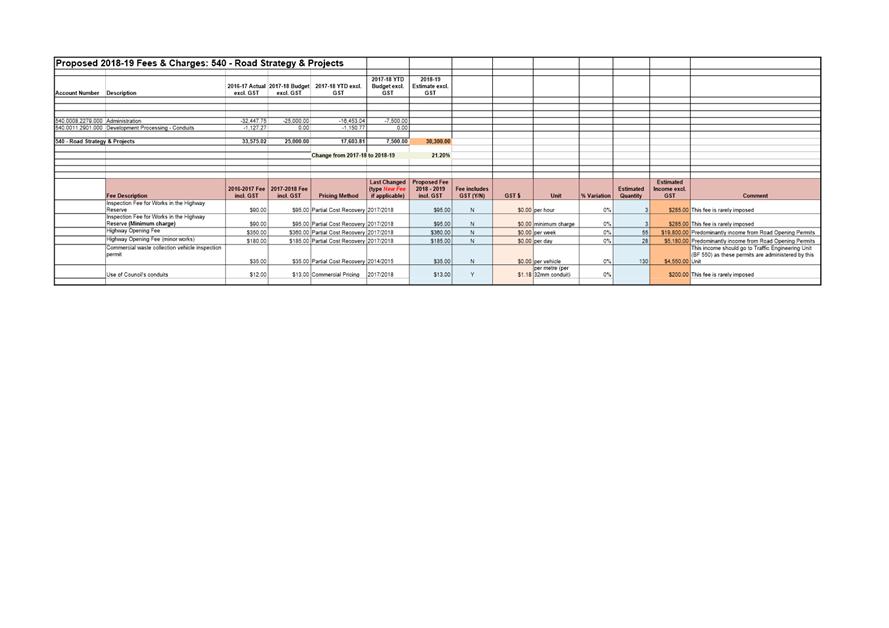
Road Strategy and Projects
5.8. These fees relate to construction works which take place in the road reservation and are most often associated with the construction or connection of underground services.
5.9. There are no fee increases proposed for this budget function.
5.10. There is little demand for the inspection fee and the fees were last increased in the 2017/2018 financial year.
5.11. As with other construction related activities it is expected that the demand for road opening permits will continue to remain strong with figures almost tripling from 2017/2018. In 2017/2018 approximately $6,200 of income was estimated, whereas approximately $20,000 is predicted in 2018/2019 due to this growth industry.
5.12. The anticipated income of $30,300 associated with this function is approximately 8% of the Division’s anticipated income.
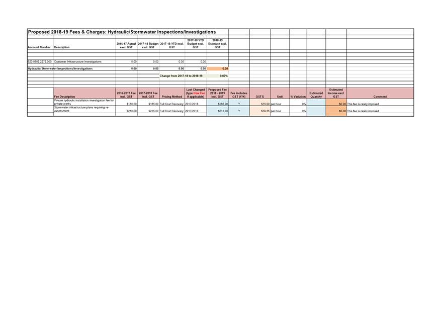
Hydraulic/Stormwater Inspections and Investigations
5.13. Investigation of private hydraulic installations is normally conducted by the private sector but can be conducted by the Council on request. This fee is rarely imposed and was last increased in 2017/2018.
5.14. Similarly, the fee for re-assessment of stormwater infrastructure plans is rarely imposed and was last increased in 2017/2018. The fee is necessary should it need to be applied when sub-standard designs are repeatedly submitted for assessment.
5.15. No income is expected from these activities during 2018/2019.
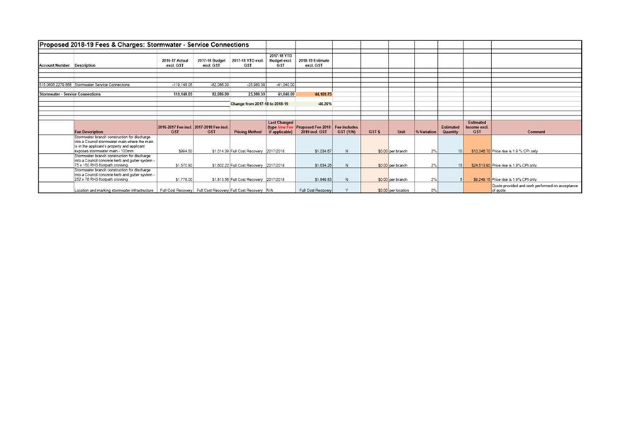
Civil Maintenance - Stormwater Service Connections
5.16. The fees associated with stormwater service connections are proposed to be increased by 2% this year in order to still represent a pricing policy of full cost recovery. The anticipated quantity is based on the level of activity during 2017/2018.
5.17. The income projection for this function is $44,109 which has almost halved from 2017/2018. This drop in income approximately represents a decrease of 46% of income from the previous year.
5.17.1. This fall in income is due to the fact that there will be a substantial decrease in the income projected for Stormwater Branch connections into Council kerbs and mains (i.e 252 x 76 footpath crossing).
5.17.2. It is anticipated that more of this work will be provided by private contractors who are directly engaged by developers.
5.18. The anticipated income of $44,110 associated with this function is approximately 12% of the Division’s anticipated income.
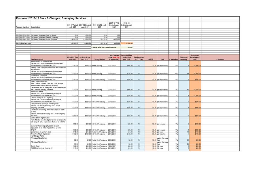
Surveying Services
5.19. There are three (3) fee increases proposed for this budget function.
They are as follows:
(i) A proposed fee increase of 20% for Sealing Final Plans for subdivision and boundary adjustments;
(ii) A proposed fee increase of 5% for Adhesion Orders; and
(iii) A proposed fee increase of 5% for Land to Form Part of a Highway.
5.20. The anticipated income of $19,490 associated with this function is approximately 5% of the Division’s anticipated income.
6. Strategic Planning and Policy Considerations
6.1. The annual review of the City’s fees and charges contributes to Goal 5 – “Governance, Leadership provides for informed decision-making for our capital city”, from the Capital City Strategic Plan 2015-2025.
6.2. In particular it aligns with Strategic Objective “5.1 - The organisation is relevant to the community and provides good governance and transparent decision-making, and
5.1.1 Undertake a review of core business systems.”
7. Financial Implications
7.1. Funding Source and Impact on Current Year Operating Result
7.1.1. Fees and charges are accounted for within the relevant budget Function areas of the 2018/2019 City Infrastructure Division.
7.1.2. The income projected for the City Infrastructure Division for 2018/2019 is $365,555 which is a decrease of approximately $17,131 or 4% from the 2017/2018 budget for those fees. This is summarised per budget function in the table below:
Function Area |
2017/2018 BUDGET |
2018/2019 |
Increase / |
|
|
F420 – Residential Parking |
$92,500 |
$116,348 |
$23,848 |
26% |
|
F550 – Traffic Strategy and Projects |
$164,700 |
$155,307 |
($9,393) |
6% |
|
F540 – Road Strategy and Projects |
$25,000 |
$30,300 |
$5,300 |
21% |
|
F620 - Hydraulic/Stormwater Inspections and Investigations |
$0 |
$0 |
$0 |
0% |
|
F515 – Civil Maintenance – Stormwater Service Connections |
$82,086 |
$44,110 |
($37,976) |
-46% |
|
F860 – Surveying Services |
$18,400 |
$19,490 |
$1,090 |
6% |
|
TOTAL |
$382,686 |
$365,555 |
($17,131) |
(-4.5%) |
7.2. Impact on Future Years’ Financial Result
7.2.1. The impact on future years’ financial results would be subject to the Council’s annual review process of fees and charges.
7.3. Asset Related Implications
7.3.1. None are foreseen.
8. Community and Stakeholder Engagement
8.1. Consultation has occurred with Divisional Budget Function Officers and the Executive Officer City Infrastructure in the preparation of this report.
9. Legal, Risk and Legislative Considerations
9.1. Pursuant to section 205 of the Local Government Act 1993, the Council may impose fees and charges for various services.
10. Delegation
10.1. Fees and charges are a matter for the Council to determine.
As signatory to this report, I certify that, pursuant to Section 55(1) of the Local Government Act 1993, I hold no interest, as referred to in Section 49 of the Local Government Act 1993, in matters contained in this report.
|
Mark Painter Director City Infrastructure |
|
Date: 19 April 2018
File Reference: F18/31000; 18/20
Attachment a: 2018/2019
Fees and Charges Schedules for City Infrastructure Division ⇩ ![]()
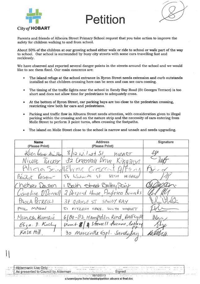
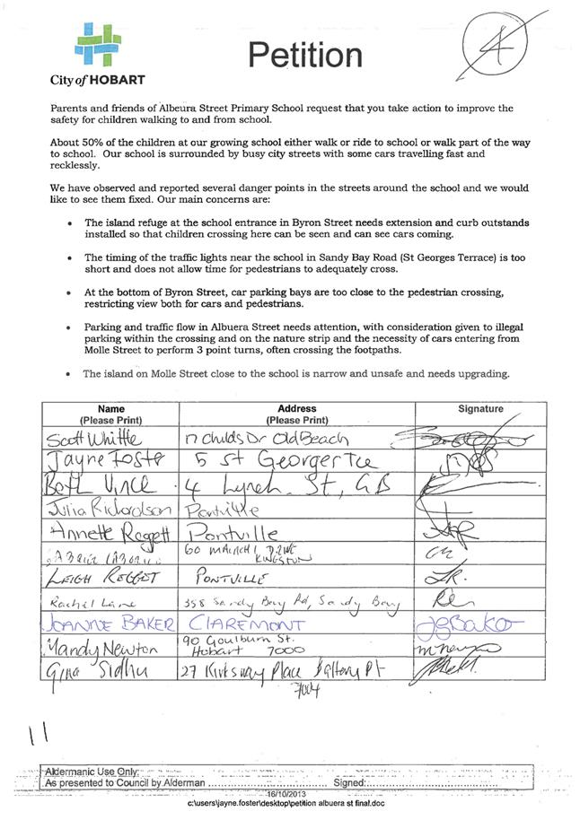
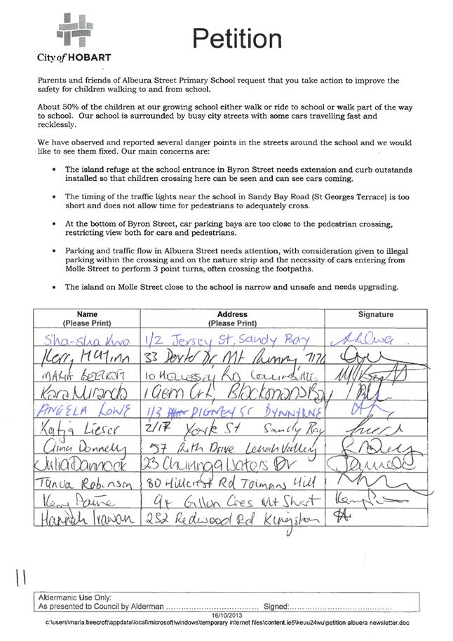
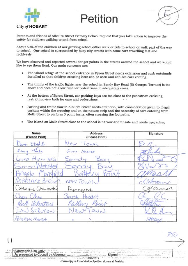
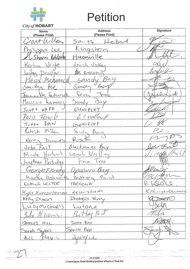
6.4 Petition - Safety of Children Walking To and From Albeura Street Primary School
Report of the Manager Traffic Engineering and the Director City Infrastructure of 19 April 2018 and attachment.
Delegation: Council
REPORT TITLE: Petition - Safety of Children Walking To and From Albeura Street Primary School
REPORT PROVIDED BY: Manager Traffic Engineering
Director City Infrastructure
1. Report Purpose and Community Benefit
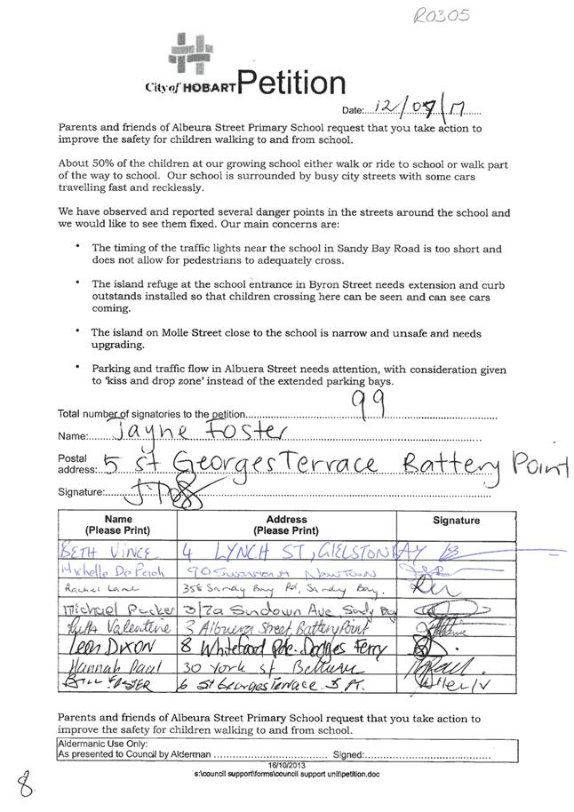
1.1. This report is provided in response to a petition tabled at the Council meeting held on Monday 7 August 2017, calling for safety improvements for children walking to and from Albeura Street Primary School.
2. Report Summary
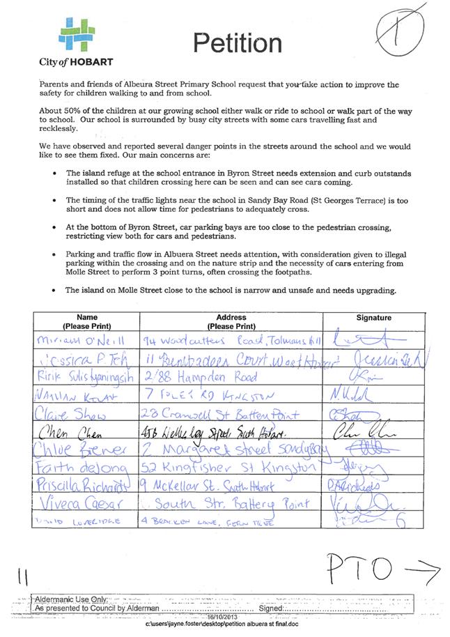
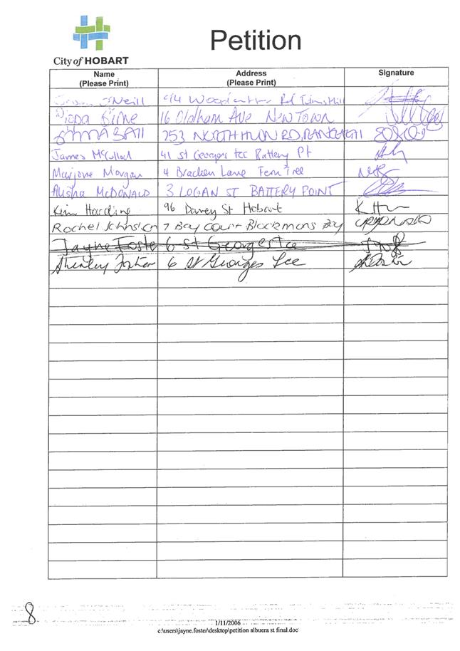
2.1. A petition containing 99 signatures (refer Attachment A to this report) was presented to the Council at its meeting held on Monday 7 August 2017. The petition highlighted the community concerns regarding the poor pedestrian environment around Albeura Street Primary School with some specific matters highlighted, including:
2.1.1. Pedestrian crossing times at the traffic signals on Sandy Bay Road (near the school).
2.1.2. The lack of kerb bulbings at the existing Byron Street pedestrian refuge near the school entrance.
2.1.3. The standard of the pedestrian refuge islands on Molle Street.
2.1.4. The parking and traffic flow in Albeura Street.
2.2. Officers have met with the representatives of the school association as well as school staff to discuss their concerns. At both of the on-site meetings, the issue of immediate safety concern was the lack of sight distance available for pedestrians (when crossing from the school side) at the Byron Street pedestrian crossing near the entrance to the school.
2.2.1. Changes to the on-street car parking were implemented to improve visibility in Byron Street (adjacent to 21 Byron Street). These changes occurred during the summer school holidays.
2.2.2. Concept designs are being developed for a kerb bulbing in this location to further improve the safety at this crossing.
2.2.3. The Department of State Growth has reviewed the operation of both the Byron Street and St Georges Terrace traffic signals. They have advised that the timings of the signals for the pedestrian crossings have been set in accordance with the Austroads Guidelines.
2.2.4. The existing median islands in Molle Street and Byron Street (near the Albuera Street / Fitzroy Place junction) have been inspected. The median islands are approximately 2 metres wide which is greater than the desirable minimum width of 1.8 metres. This width allows for a cyclist, someone pushing a pram or wheelchair, or a mobility scooter to wait whilst crossing the road. No further work is proposed at this location.
2.2.5. Officers continue to work with the school community to implement what parking controls might assist the school operations, recognising that there is limited space available for on-street parking in the vicinity of the school. No changes to on-street parking controls are proposed for Albeura Street.
|
That: 1. Matters raised in the petition relating to the safety of children walking to and from Albeura Street Primary School be received and noted. 2. The changes to on-street parking in Byron Street (at the school entrance) to improve sight distance for pedestrians using the median island crossing, be received and noted. 3. The following recommendations to further improve the safety of children walking to and from Albeura Street be endorsed: (a) Investigate and if feasible, list for consideration in the Capital Works Program the provision of a kerb bulbing in Byron Street (at the school entrance), to provide protection for pedestrians crossing the southbound lane, improve sight distance and deter motorists from parking illegally in this location; and (b) Officers continue to work with the school in relation to on‑street parking controls in Albeura Street. 4. The organiser of the petition be advised of the Council’s decision.
|
4. Background
4.1. A petition containing 99 signatures (refer Attachment A to this report) was presented to the Council at its meeting held on Monday 7 August 2017. The petition highlighted the community concerns regarding the poor pedestrian environment around Albeura Street Primary School with some specific matters highlighted, including:
4.1.1. Pedestrian crossing times at the traffic signals on Sandy Bay Road (near the school).
4.1.2. The lack of kerb bulbings at the existing Byron Street pedestrian refuge near the school entrance.
4.1.3. The standard of the pedestrian refuge islands on Molle Street.
4.1.4. The parking and traffic flow in Albeura Street.
4.2. Figure 1 (below) shows the area near Albeura Street Primary School and indicates the location of the issues raised in the petition.
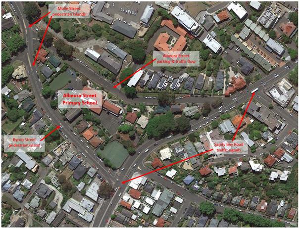
Figure 1 – Location Plan.
4.3. There is a variable 40 km/h school zone that operates in Albeura Street, Byron Street and Molle Street on school days during the morning drop‑off and afternoon pick‑up periods. There is a children’s crossing on Albeura Street that operates during the same times.
4.4. On 14 September 2017, officers met with the Principal of the Albeura Street Primary School and a representative of the Albeura Street Primary School Association to discuss the matters raised in the petition.
4.5. A number of Aldermen and officers met with representatives of the Albeura Street Primary School Parents and Friends Association and staff of the school on 24 November 2017 to further discuss the matters raised in the petition and to observe the issues highlighted.
4.6. On both occasions, the issue of immediate safety concern was the lack of sight distance available for pedestrians (when crossing from the school side) at the Byron Street pedestrian crossing near the entrance to the school.
4.7. The crash history for the area has also been reviewed. In the last five years the following crashes have been reported:
4.7.1. Albeura Street (between Byron Street and Sandy Bay Road) had no crashes reported.
4.7.2. Three crashes were reported at the Albeura Street / Byron Street / Fitzroy Place / Molle Street intersection. Two were minor injury crashes and all involved a right turning vehicle failing to giveway. None of the crashes occurred when the 40 km/h school zone was in effect.
4.7.3. Nine crashes were reported on Byron Street (between Albeura Street and Sandy Bay Road). One occurred during the 40 km/h school zone period, involved a single vehicle and was recorded as a property damage only crash.
4.7.4. 14 crashes were reported at the Byron Street / Sandy Bay Road signalised intersection – with five of these involving vehicles travelling on the Byron Street approach to the junction. Two crashes were reported during the morning school drop off period and both were recorded as minor injury crashes. One was a rear-end collision between two cars and the other was a single vehicles collision involving a motorcycle in wet weather.
4.7.5. Eight crashes were reported on Sandy Bay Road (between Byron Street and St Georges Terrace) but none occurred during school drop off and pick up periods.
4.7.6. Six crashes were reported at the St Georges Terrace / Sandy Bay Road signalised intersection and one of these occurred on a weekday during the afternoon school pick‑up period. It was a rear‑end collision between two vehicles and involved property damage only.
4.8. The reported crash history is consistent with the traffic volumes and the road environment of these roads around Albeura Street Primary School and does not indicate any significant road safety concerns.
5. Proposal and Implementation
5.1. Officers have met with representatives of the school association as well as school staff to discuss their concerns. At both of the on-site meetings, the issue of immediate safety concern was the lack of sight distance available for pedestrians (when crossing from the school side) at the Byron Street pedestrian crossing near the entrance to the school.
5.2. Sandy Bay Road Traffic Signals
5.2.1. The Department of State Growth has reviewed the operation of both the Byron Street and St Georges Terrace traffic signals. They have advised that the timings of the signals for the pedestrian crossings have been set in accordance with the Austroads Guidelines.
5.2.2. It should be noted that the flashing red “Don’t Walk” signal lasts quite a long time so that even if a pedestrian starts to cross the road at the very end of the green “Walk” signal, there is still sufficient time to allow that person to get fully across the road.
5.2.3. It is noted that the footpath is very narrow on Sandy Bay Road due to pedestrian fencing. However, there is limited opportunity to widen the path here without having negative impacts on traffic capacity on Sandy Bay Road.
5.2.4. Photos of the Byron Street and St Georges Terrace traffic signals are included below as Figure 2 and Figure 3 respectively.
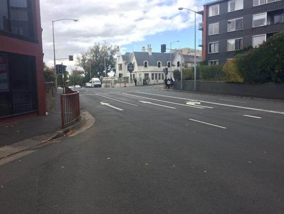
Figure 2 – Byron Street / Sandy Bay Road traffic signals.
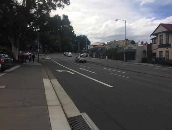
Figure 3 – St Georges Terrace / Sandy Bay Road traffic signals.
5.3. Byron Street Pedestrian Island
5.3.1. Changes to the on-street car parking were implemented to improve visibility in Byron Street (adjacent to 21 Byron Street). These changes occurred during the summer school holidays.
5.3.2. Concept designs are being developed for a kerb bulbing in this location to further improve the safety at this crossing.
5.3.3. Photos of the Byron Street pedestrian island are included below as Figure 4.
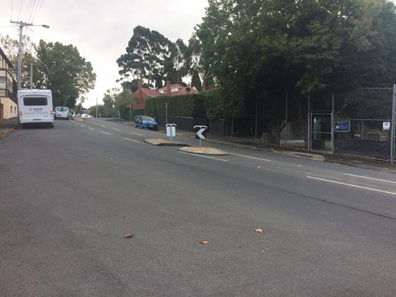
Figure 4 – Byron Street pedestrian island.
5.4. Molle Street Pedestrian Islands
5.4.1. The existing median islands in Molle Street and Byron Street (near the Albuera Street / Fitzroy Place junction) have been inspected. The median islands are approximately 2 metres wide which is greater than the desirable minimum width of 1.8 metres. This width allows for a cyclist, someone pushing a pram or wheelchair, or a mobility scooter to wait whilst crossing the road. No further work is proposed at this location.
5.4.2. Photos of the Molle Street pedestrian islands are included below as Figure 5 and Figure 6.
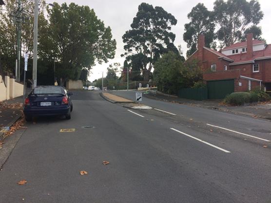
Figure 5 – Molle Street pedestrian island (south of Albeura Street)
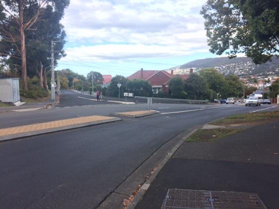
Figure 6 – Molle Street pedestrian island (north of Albeura Street).
5.5. Albeura Street Parking and Traffic Flow
5.5.1. The parking controls in Albuera Street have been the subject of an ongoing discussion between the school and Council officers for many years. Prior to 2012 there was a “No Parking” zone in Albuera Street which allowed for a “Kiss & Drop” arrangement. However, in 2012 the Principal wrote to the Council suggesting that parents were finding this arrangement confusing and requested that 5 minute parking be installed instead. Parking changes were made in response to this request and these arrangements have remained for the last 5 years (although has been increased to ¼P parking, again in response to requests from the school community).
5.5.2. Officers continue to work with the school community to implement what parking controls might assist the school operations, recognising that there is limited space available for on-street parking in the vicinity of the school.
5.5.3. It should be noted that there is a short “No Parking” zone in Byron Street that allows for “Kiss & Drop” during school drop off and pick up periods.
5.5.4. Again, no changes to on-street parking controls are proposed for Albeura Street.
6. Strategic Planning and Policy Considerations
6.1. The improvements recommended in this report for the streets around Albeura Street Primary School are supported by Strategic Objective 2.1 of the Capital City Strategic Plan 2015-2025 as follows:
“2.1 A fully accessible and connected city environment.
2.1.3 Identify and Implement infrastructure improvements to enhance road safety.”
7. Financial Implications
7.1. Funding Source and Impact on Current Year Operating Result
7.1.1. There are currently no funding sources identified. However, the minor upgrades already implemented have been absorbed into existing operating budgets.
7.2. Impact on Future Years’ Financial Result
7.2.1. Any projects (such as the kerb bulbing in Byron Street) would need to be budgeted in future years based on preliminary designs to inform an estimated cost.
7.3. Asset Related Implications
7.3.1. The implementation of a kerb bulbing in Byron Street near the Albeura Street Primary School may result in some minor asset related implications, such as write off and depreciation.
8. Community and Stakeholder Engagement
8.1. Officers have met with representatives of the school association as well as school staff to discuss their concerns. At both on-site meetings, the issue of immediate safety concern was the lack of sight distance available for pedestrians (when crossing from the school side) at the Byron Street pedestrian crossing near the entrance to the school.
9. Delegation
9.1. This is a matter for the Council to determine
As signatory to this report, I certify that, pursuant to Section 55(1) of the Local Government Act 1993, I hold no interest, as referred to in Section 49 of the Local Government Act 1993, in matters contained in this report.
|
Angela Moore Manager Traffic Engineering |
Mark Painter Director City Infrastructure |
Date: 19 April 2018
File Reference: F18/31660
Attachment a: Petition
- Safety of Children Walking to and from Albeura Street Primary School ⇩ ![]()
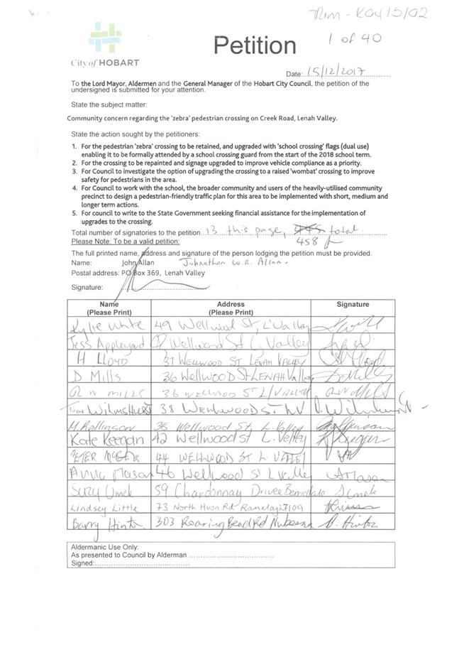
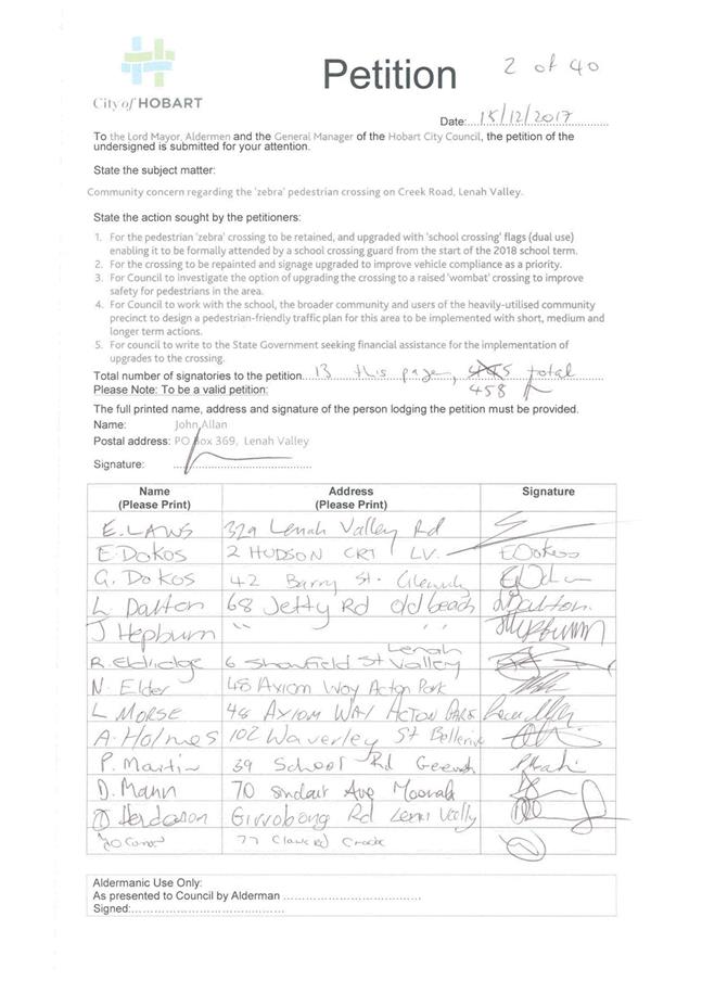
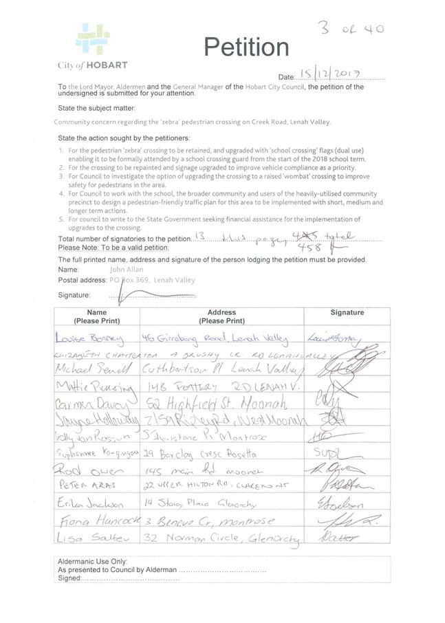
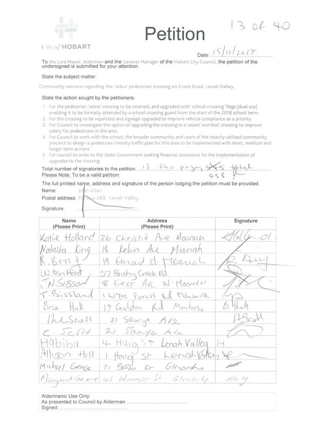
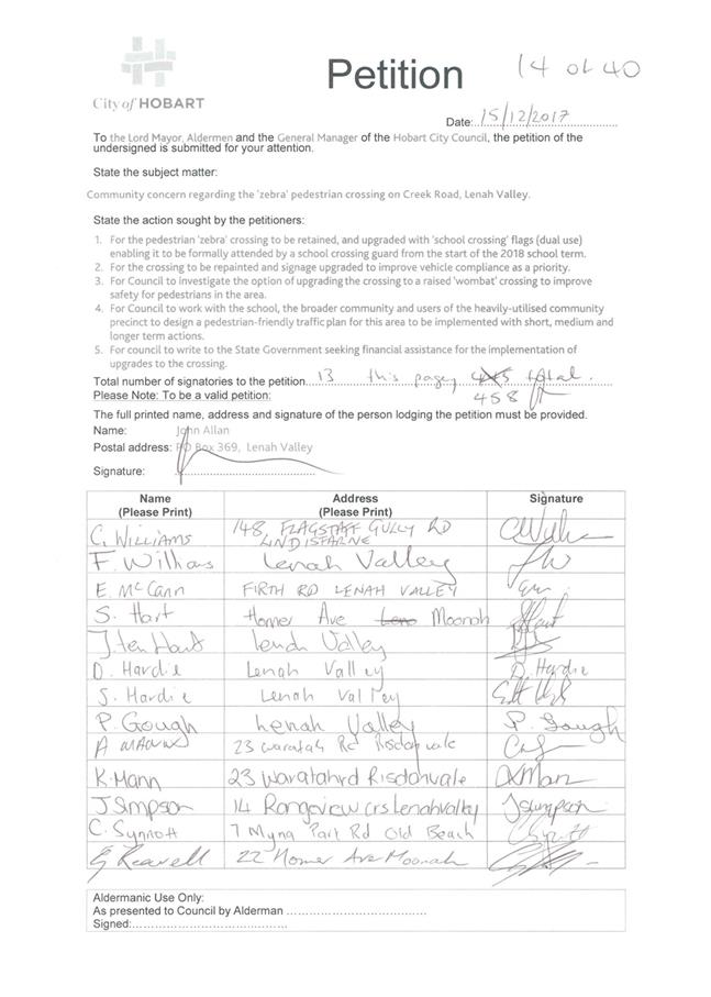
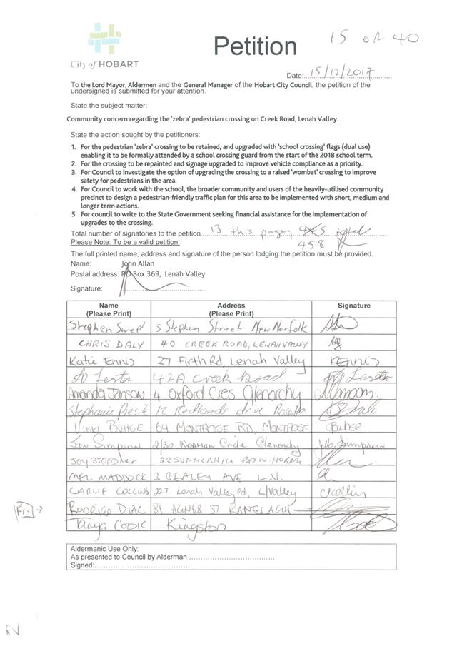
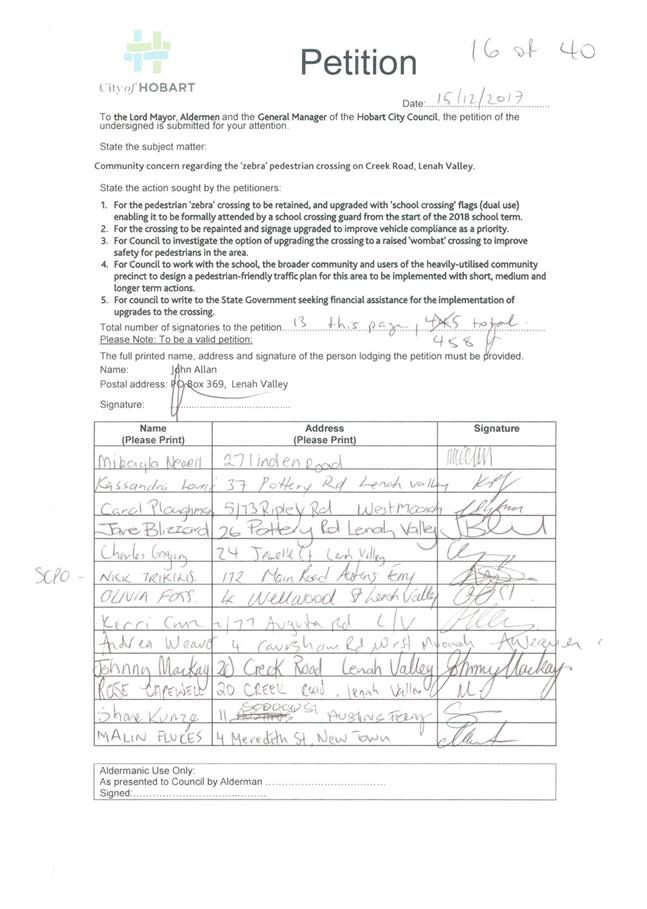
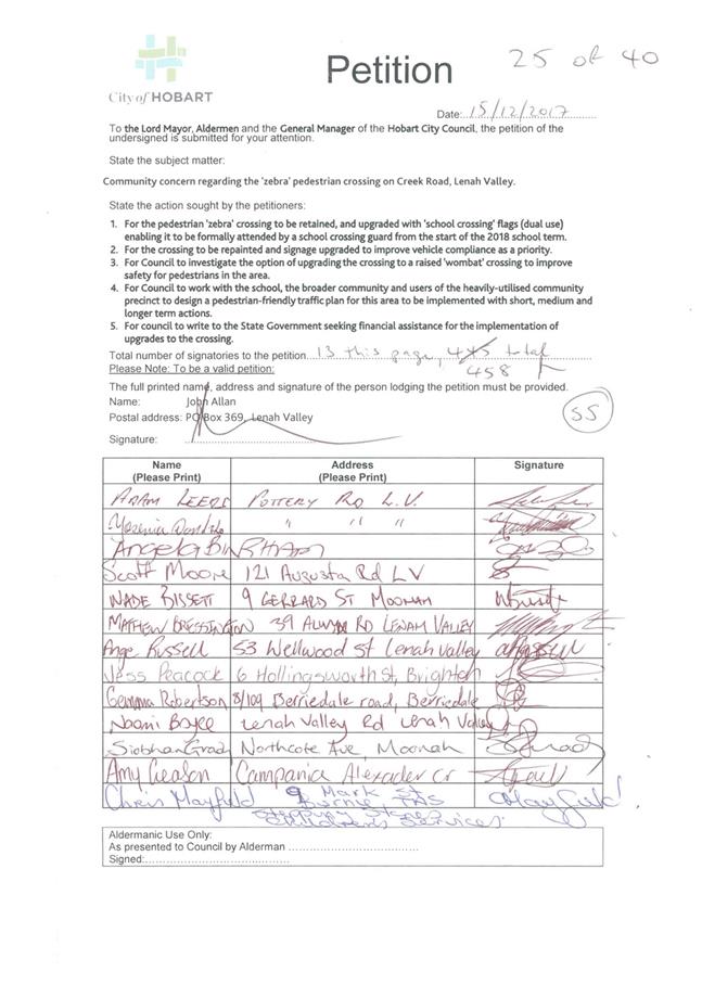
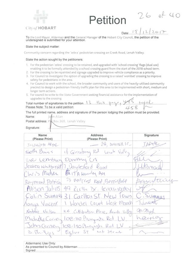
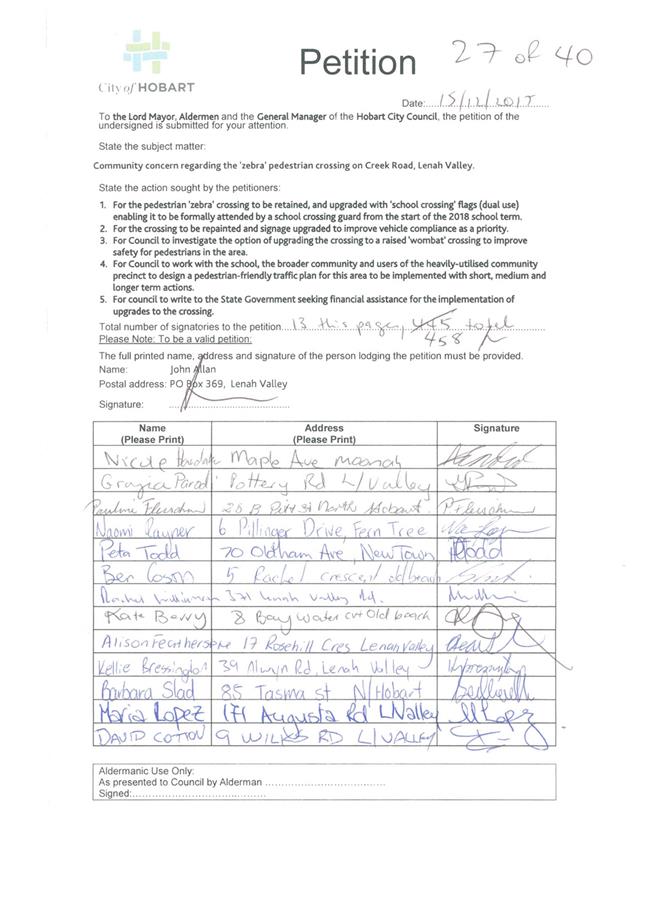
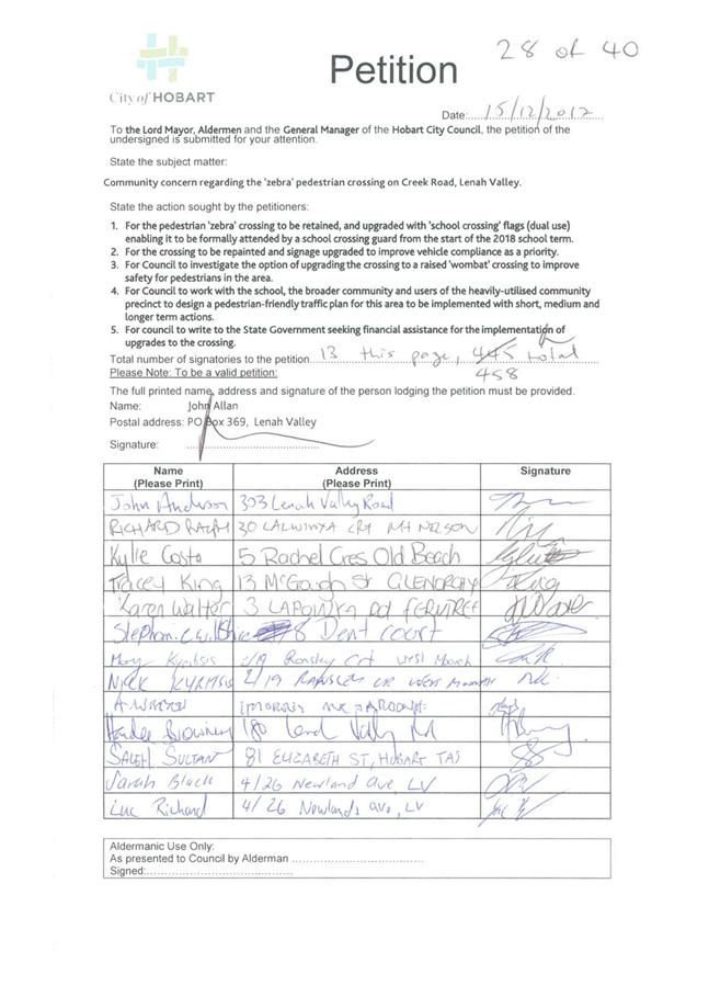
6.5 Petition - Pedestrian (Zebra) Crossing on Creek Road, Lenah Valley
Report of the Manager Traffic Engineering and the Director City Infrastructure of 19 April 2018 and attachment.
Delegation: Council
REPORT TITLE: Petition - Pedestrian (Zebra) Crossing on Creek Road, Lenah Valley
REPORT PROVIDED BY: Manager Traffic Engineering
Director City Infrastructure
1. Report Purpose and Community Benefit
1.1. This report is provided in response to a petition tabled at the Council meeting held on Monday 18 December 2017, calling for the retention of the pedestrian (zebra) crossing in Creek Road along with suggestions for a number of other road safety improvements in the vicinity of Lenah Valley Primary School.
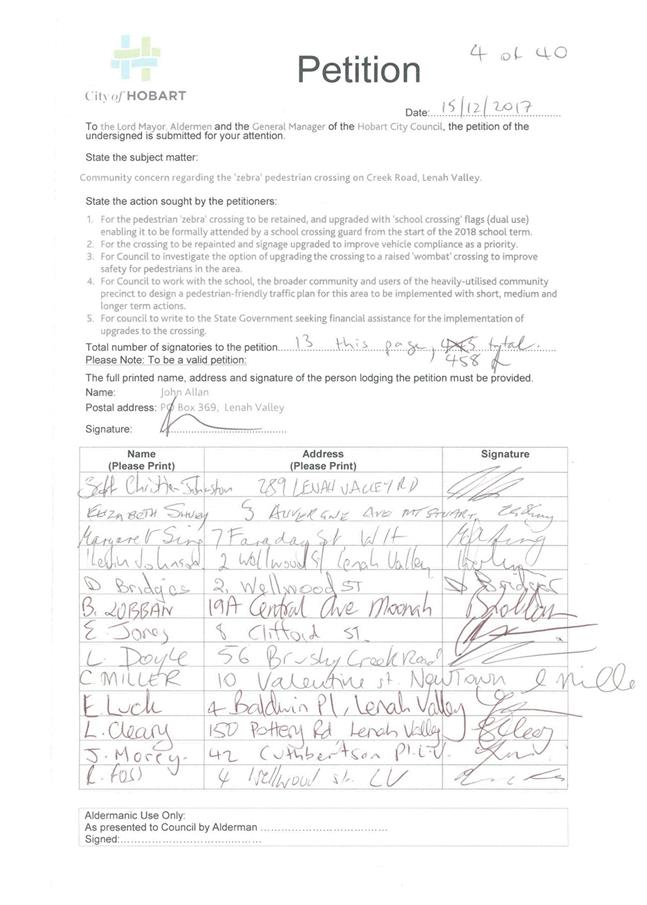
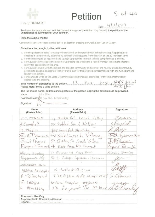
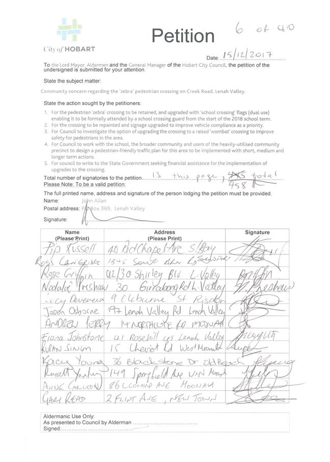
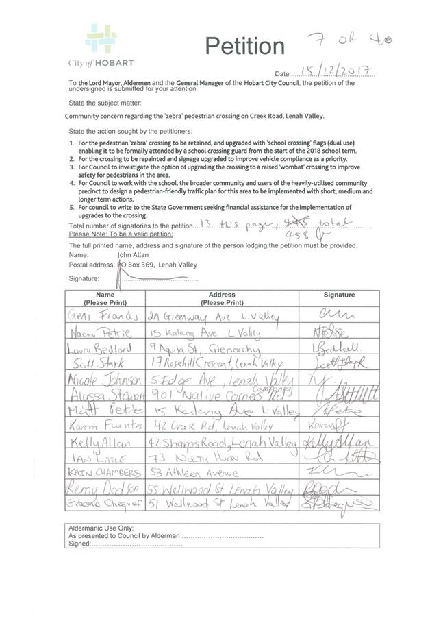
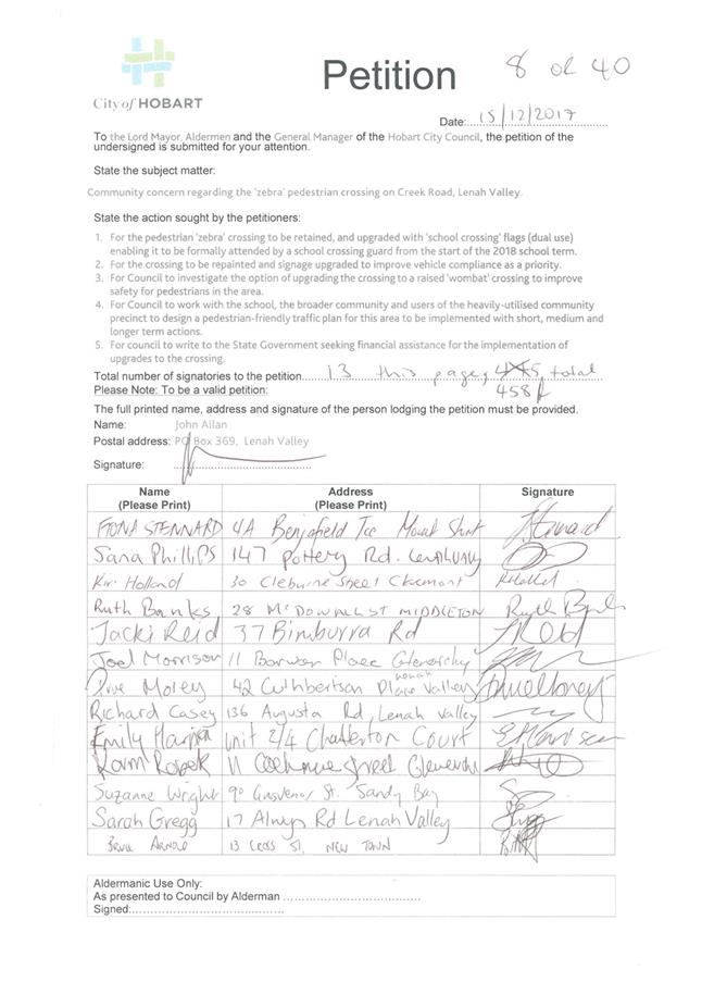
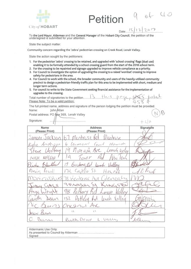
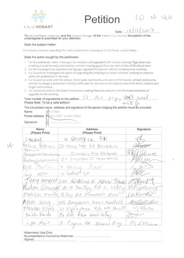
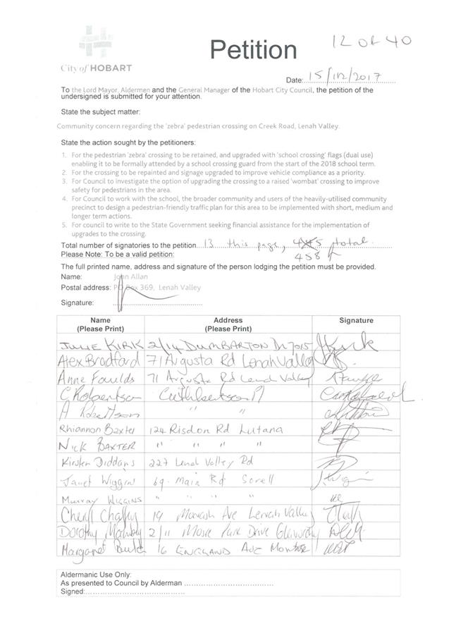
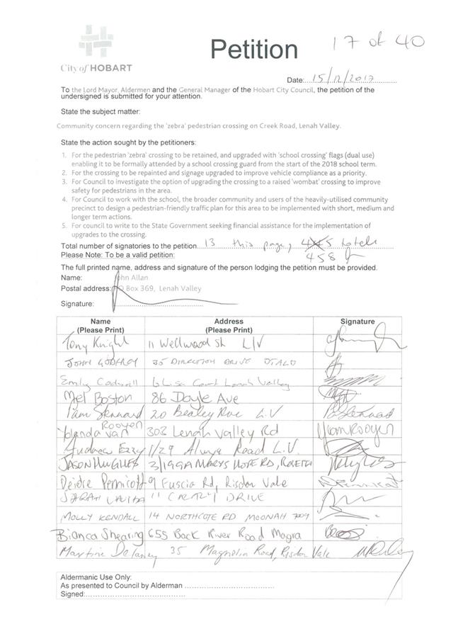
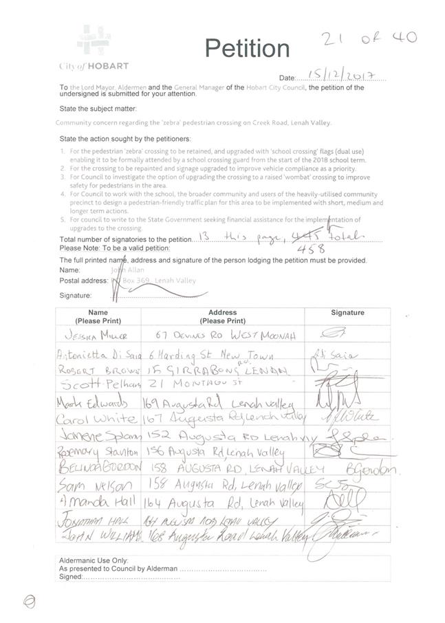
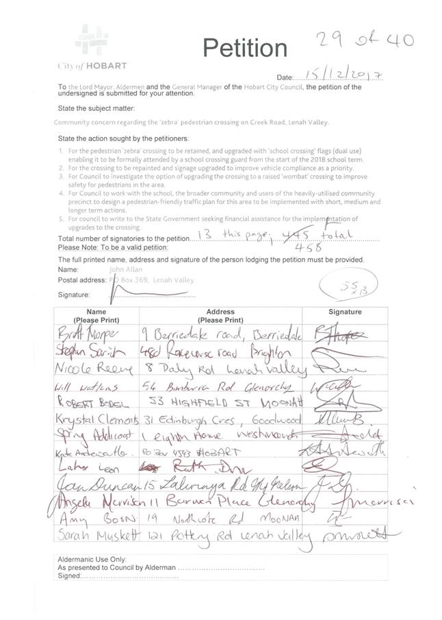
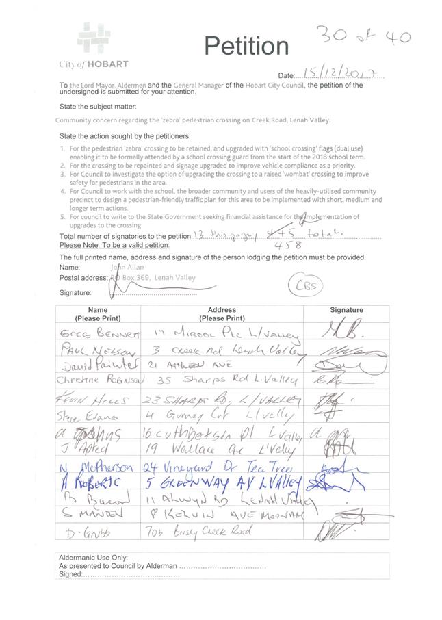
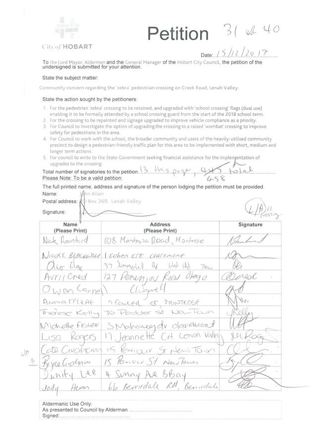
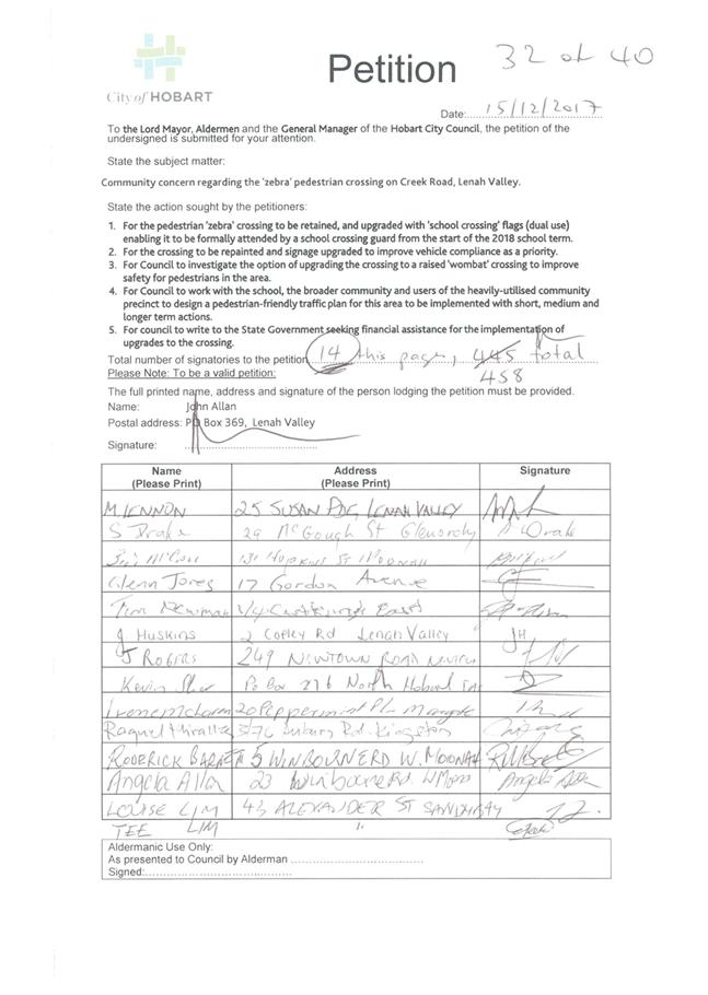
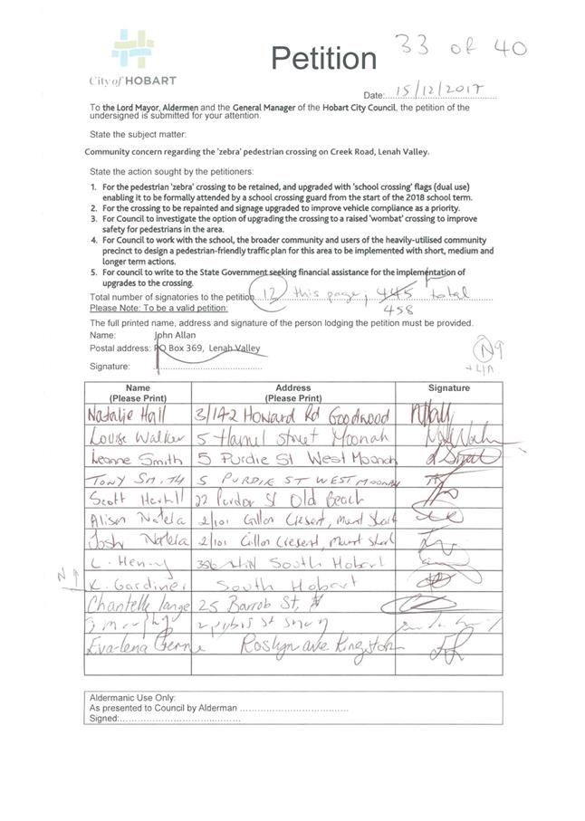
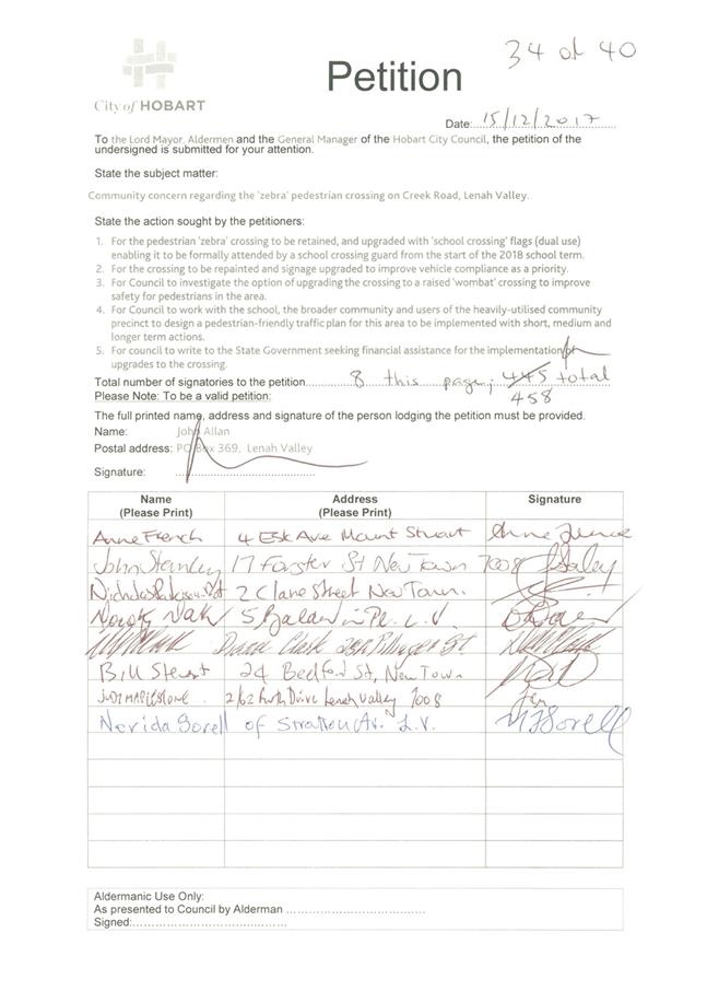
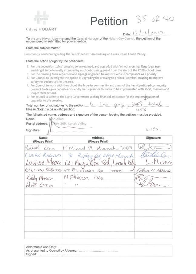
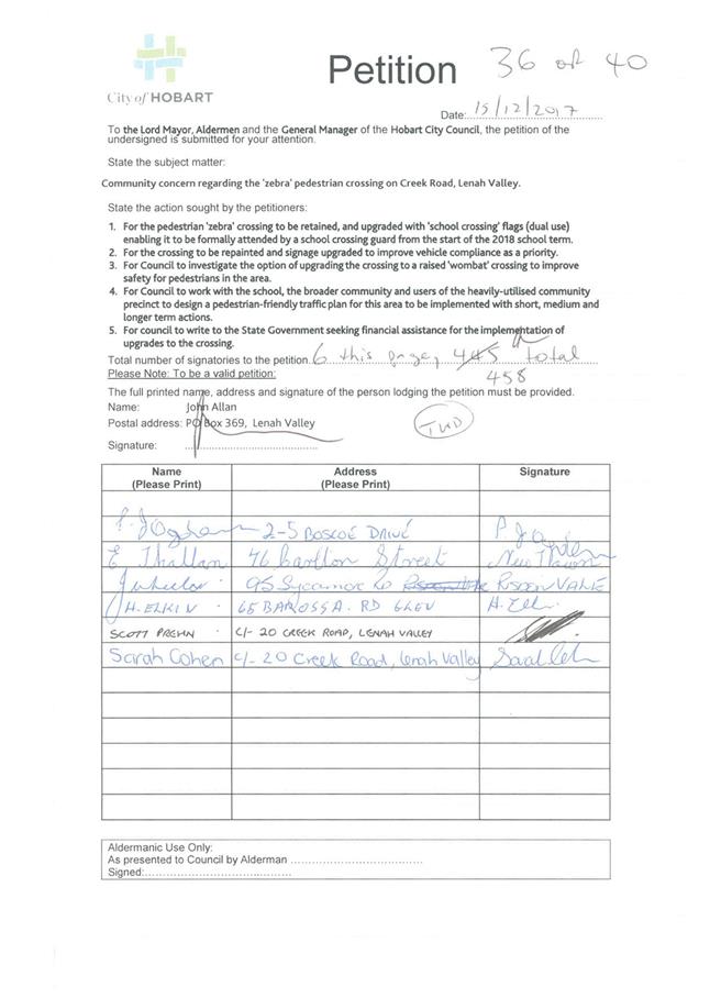
2. Report Summary
2.1. A petition containing 458 signatures (refer Attachment A to this report) was presented to the Council at its meeting held on Monday 18 December 2017. The petition highlighted the community concerns regarding the pedestrian (zebra) crossing in Creek Road and suggested a number of road safety improvements in the vicinity of Lenah Valley Primary School, including:
2.1.1. Retention of the pedestrian (zebra) crossing in Creek Road and the use of “school crossing” flags when the school crossing patrol officer is present.
2.1.2. Repainting the linemarking at the pedestrian (zebra) crossing.
2.1.3. Consideration of upgrading the pedestrian (zebra) crossing to a raised pedestrian (wombat) crossing.
2.1.4. Development of a pedestrian plan for the Lenah Valley Primary School.
2.1.5. Seeking funding from the Department of State Growth for improvement works.
2.2. A number of the requests in the petition have been addressed, as follows:
2.2.1. Works were completed at the Creek Road pedestrian (zebra) crossing over the 2017‑2018 summer school holidays including a slight relocation of the crossing to improve street lighting, a localised asphalt overlay, remarking the linemarking at the crossing and footpath renewals adjacent to the school. This was funded by the Council and no additional funding was sought from the Department of State Growth.
2.2.2. The Road Safety Branch of the Department of State Growth has amended its operating procedures for its School Crossing Patrol Officers (SCPO) to allow them to work on a zebra crossing as well as a children’s crossing. Additional “school crossing” flags are not necessary to support this operation nor are they required under the relevant Australian Standards.
2.3. A wombat crossing trial has been approved for Hill Street, West Hobart. No additional wombat crossing would be considered until such time as the trial has been assessed. Therefore, consideration of a raised wombat crossing in Creek Road has not been progressed at this time.
2.4. Further works have also been identified to improve pedestrian access in the vicinity of Lenah Valley Primary School, including:
2.4.1. Concept designs will be developed for a continuous footpath treatment across Wellwood Street at Creek Road to improve pedestrian access and visibility at this location. Planning works around this new traffic management arrangement would need to consider the need (or otherwise) for an adult crossing guard at this location. Officers would continue to work with the Road Safety Branch of the Department of State Growth in relation to this matter.
2.4.2. Further to the Council resolution of 2 October 2017, officers are progressing the implementation of projects outlined in the City of Hobart Active Travel Report, which includes a desire for the Council to promote the report and encourage the Department of State Growth to support the Active Routes to School programs in the greater Hobart area. Work will include working with schools to further highlight the access routes to and from the school and what interventions might be necessary along those corridors to improve active travel.
|
That: 1. Matters raised in the petition relating to the pedestrian (zebra) crossing in Creek Road and other road safety matters near Lenah Valley Primary School be received and noted. 2. The changes to the zebra crossing in Creek Road (implemented during January and February 2018) to improve street lighting and the linemarking at this crossing, be received and noted. 3. The following recommendations to further improve the safety of the pedestrian (zebra crossing) on Creek Road, Lenah Valley be endorsed:
(a) Investigate and if feasible, list for consideration in the Capital Works Program the provision of a “continuous footpath” across the Wellwood Street intersection at Creek Road to improve pedestrian access to Lenah Valley Primary School; (b) Officers continue to progress the City of Hobart Active Travel Report and Active Routes to School programs in the greater Hobart area (as per the Council resolution of 2 October 2017); and (c) A wombat crossing not be considered for Creek Road, until such time as the Hill Street trial has been assessed. 4. The organiser of the petition be advised of the Council’s decision. |
4. Background
4.1. On Thursday 7 December 2017 the Director City Infrastructure and Manager Traffic Engineering met with the Lenah Valley Primary School Principal and Business Manager, representatives of the Lenah Valley Primary School Association, and other interested community members – to observe the operation of the current pedestrian crossing during school drop‑off times and to discuss the proposal to change the existing crossing to a children’s crossing. Alderman Anna Reynolds was also at the meeting.
4.2. At this meeting it was agreed that a number of matters needed to be progressed prior to the start of the 2018 school year, including renewal of the Creek Road linemarking to improve the delineation and conspicuousness of the pedestrian crossing.
4.3. A petition containing 458 signatures (refer Attachment A to this report) was subsequently presented to the Council at its meeting held on Monday 18 December 2017. The petition highlighted the community concerns regarding the pedestrian (zebra) crossing in Creek Road and suggested a number of road safety improvements in the vicinity of Lenah Valley Primary School, including:
4.3.1. Retention of the pedestrian (zebra) crossing in Creek Road and the use of “school crossing” flags when the school crossing patrol officer is present.
4.3.2. Repainting the linemarking at the pedestrian (zebra) crossing.
4.3.3. Consideration of upgrading the pedestrian (zebra) crossing to a raised pedestrian (wombat) crossing.
4.3.4. Development of a pedestrian plan for the Lenah Valley Primary School.
4.3.5. Seeking funding from the Department of State Growth for improvement works.
4.4. In response to the community meeting and the petition, officers reviewed the assessment of the pedestrian crossing type warranted in Creek Road. Warrants are met for a zebra crossing at this location and therefore this type of crossing will be retained. However, the location of the crossing did not have suitable street lighting and was shifted approximately 3 metres south towards Wellwood Street where there is appropriate street lighting. These works were completed over January and February 2018 and included an extended kerb outstand, a localised asphalt overlay and new zebra crossing linemarking (shown in the photograph at Figure 1 below).
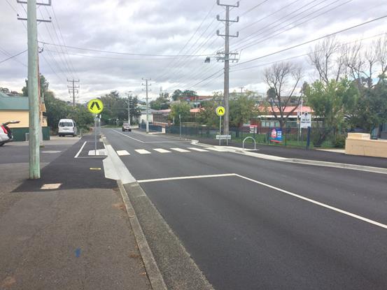
Figure 1 – Creek Road pedestrian (zebra) crossing.
4.5. The signage and linemarking for the pedestrian (zebra) crossing comply with the Australian Standards and no additional infrastructure is required to allow an adult crossing guard to operate on this type of crossing. The Road Safety Branch of the Department of State Growth has amended its operating procedures for its School Crossing Patrol Officers (SCPO) to allow them to work on a zebra crossing as well as a children’s crossing.
4.6. In relation to the request for consideration of a raised “wombat” crossing be considered for this location, the Council (at its meeting of 2 October 2017) agreed to the trial of this type of traffic management device in Hill Street, West Hobart. No further wombat crossings would be considered until the trial has been assessed.
4.7. It was also noted that the crossing facilities provided in Wellwood Street near the Creek Road intersection could be improved (see Figure 2). The crossing is currently managed as a children’s crossing (with a SCPO being provided on a temporary basis). It is considered that this crossing could be improved through the introduction of a “continuous footpath” treatment to improve visibility of pedestrians in this location, particularly to drivers turning from Creek Road into Wellwood Street.
Figure 2 – Wellwood Street children’s crossing, at Creek Road.
5. Proposal and Implementation
5.1. Works were completed at the Creek Road pedestrian (zebra) crossing over the 2017‑2018 summer school holidays including a slight relocation of the crossing to improve street lighting, a localised asphalt overlay, remarking the linemarking at the crossing and footpath renewals adjacent to the school. This was funded by the Council and no additional funding was sought from the Department of State Growth.
5.2. The Road Safety Branch of the Department of State Growth has amended its operating procedures for its School Crossing Patrol Officers (SCPO) to allow them to work on a zebra crossing as well as a children’s crossing. Additional “school crossing” flags are not necessary to support this operation nor are they required under the relevant Australian Standards.
5.3. A wombat crossing trial has been approved for Hill Street, West Hobart. No additional wombat crossing would be considered until such time as the trial has been assessed. Therefore, consideration of a raised wombat crossing in Creek Road has not been progressed at this time.
5.4. Concept designs will be developed for a continuous footpath treatment across Wellwood Street at Creek Road to improve pedestrian access and visibility at this location. Planning works around this new traffic management arrangement would need to consider the need (or otherwise) for an adult crossing guard at this location. Officers would continue to work with the Road Safety Branch of the Department of State Growth in relation to this matter.
5.5. Further to the Council resolution of 2 October 2017, officers are progressing the implementation of projects outlined in the City of Hobart Active Travel Report, which includes a desire for the Council to promote the report and encourage the Department of State Growth to support the Active Routes to School programs in the greater Hobart area. Work will include working with schools to further highlight the access routes to and from the school and what interventions might be necessary along those corridors to improve active travel.
6. Strategic Planning and Policy Considerations
6.1. The improvements recommended in this report in relation to the zebra crossing in Creek Road and other road safety matters in the vicinity of Lenah Valley Primary School are supported by Strategic Objective 2.1 of the Capital City Strategic Plan 2015-2025 as follows:
“2.1 A fully accessible and connected city environment.
2.1.3 Identify and Implement infrastructure improvements to enhance road safety.”
7. Financial Implications
7.1. Funding Source and Impact on Current Year Operating Result
7.1.1. Works to improve the street lighting and linemarking at the Creek Road pedestrian (zebra) crossing have been funded through the existing capital works program (through a combination of renewal funds and annual allocations for local area traffic management upgrade works).
7.1.2. No funding was sought from the Department of State Growth as these works are on the City of Hobart road network. The urgency of these works meant that applying for grant funding was not possible.
7.2. Impact on Future Years’ Financial Result
7.2.1. Any projects (such as the continuous footpath in Wellwood Street or improvements identified in a pedestrian plan for the school) would need to be budgeted in future years based on preliminary designs to inform an estimated cost.
7.3. Asset Related Implications
7.3.1. None are identified.
8. Community and Stakeholder Engagement
8.1. Consultation with the organiser of the petition has been undertaken on the measures implemented to date and the works to be investigated to improve the pedestrian visibility and access at the Wellwood Street intersection. The organiser of the petition was satisfied with the intended actions.
9. Delegation
9.1. This is a matter for the Council to determine.
As signatory to this report, I certify that, pursuant to Section 55(1) of the Local Government Act 1993, I hold no interest, as referred to in Section 49 of the Local Government Act 1993, in matters contained in this report.
|
Angela Moore Manager Traffic Engineering |
Mark Painter Director City Infrastructure |
Date: 19 April 2018
File Reference: F18/31662
Attachment a: Petition
- Zebra crossing on Creek Road, Lenah Valley ⇩ ![]()
6.6 7 Woolton Place, Sandy Bay - Further Investigation of Potential Traffic Issues Due to Partial Change of Use to Food Services
Memorandum of the Director City Infrastructure of 19 April 2018.
Delegation: Committee

Memorandum: City Infrastructure Committee
7 Woolton Place, Sandy Bay - Further Investigation of Potential Traffic Issues Due to Partial Change of Use to Food Services
Background
The owners of 7 Woolton Place, Sandy Bay applied for partial demolition, alterations, extension and partial change of use to food services at their property (refer to item 7.2.1.7 of the Open City Planning Committee Agenda of 26 February 2018).
At its meeting held on 26 February 2018, the City Planning Committee approved the application with the addition of Part B to the recommendation as follows:
“B. That the management of potential traffic issues be referred onto the City
Infrastructure Committee for review and further investigation.”
Outcome
Further investigation has been undertaken and the Manager Traffic Engineering has advised that no potential traffic issues are envisaged as a result of the partial change of use due to there being no increase in traffic volume to and from the property.
|
That the information be received and noted.
|
As signatory to this report, I certify that, pursuant to Section 55(1) of the Local Government Act 1993, I hold no interest, as referred to in Section 49 of the Local Government Act 1993, in matters contained in this report.
|
Mark Painter Director City Infrastructure |
|
Date: 19 April 2018
File Reference: F18/32226; PLN-18-11
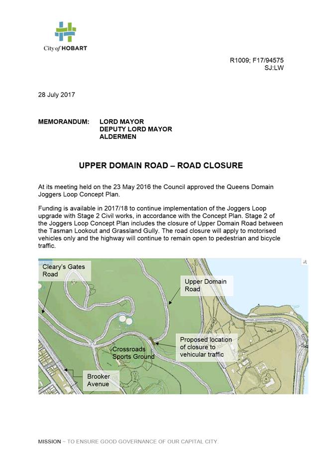
6.7 Upper Domain Road – Road Closure – Review of Representations
Memorandum of the Manager Traffic Engineering and the Director City Infrastructure of 19 April 2018 and attachments.
Delegation: Council
Memorandum: City Infrastructure Committee
Upper Domain Road – Road Closure – Review of Representations
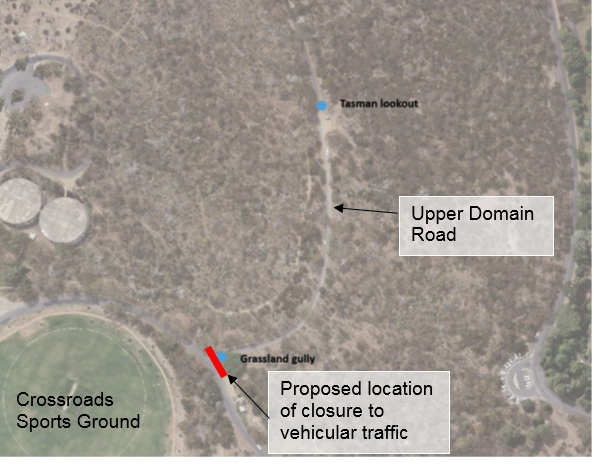
This memorandum details written submissions received on the proposed closure of Upper Domain Road between the Tasman Lookout and Grassland Gully.
At its meeting held on 23 May 2016, the Council approved the Queens Domain Joggers Loop Concept Plan. Funding is available to continue implementation of the Joggers Loop upgrade with Stage 2 civil works being implemented in accordance with the Concept Plan. Stage 2 of the Joggers Loop Concept Plan includes the closure of Upper Domain Road between the Tasman Lookout and Grassland Gully (as shown on the plan below).
![]()
![]()
![]()
![]()
![]()
![]()
The road closure will apply to motorised vehicles only and the highway will continue to be available for use by pedestrian and bicycle traffic.
A memorandum dated 28 July 2017 was sent to all Aldermen and the General Manager (included as Attachment A to this memorandum) detailing the process for the statutory road closure of Upper Domain Road as set out in Section 31 of the Local Government (Highways) Act 1982.
In accordance with the statutory requirement, advertisements were placed in The Mercury on 28 October 2017 and 4 November 2017. The due date for written representations was 24 November 2017 (28 days from date of first advertisement).
A total of four representations were received from the community and all related to the road closure at Upper Domain Road (between the Tasman Lookout and Grassland Gully).
During the statutory advertisement period, a submission was also received from the Tasmanian Dog Walking Club addressing concerns raised by a member of their group in relation to access. From a conversation with the President of the Tasmanian Dog Walking Club, it came to light that the club were considering another section of Upper Domain Road and not the section between Tasman Lookout and Grassland Gully. Once the location was clarified the club was supportive of the proposal.
Given all written representations received were for the road closure at Upper Domain Road, it is proposed that an application be submitted to the Transport Commission in accordance with Section 31 of the Local Government (Highways) Act 1982.
|
Item No. 6.7 |
Agenda (Open Portion) City Infrastructure Committee Meeting |
Page 122 |
|
|
26/4/2018 |
|
|
That: 1. An application be made to the Transport Commission seeking closure of Upper Domain Road (between the Tasman Lookout and Grassland Gully) in accordance with Section 31 of the Local Government (Highways) Act 1982. 2. The matter be considered by the Council.
|
As signatory to this report, I certify that, pursuant to Section 55(1) of the Local Government Act 1993, I hold no interest, as referred to in Section 49 of the Local Government Act 1993, in matters contained in this report.
|
Angela Moore Manager Traffic Engineering |
Mark Painter Director City Infrastructure |
Date: 19 April 2018
File Reference: F18/32376
Attachment a: Memo on Statutory Road Closure Process dated 28 July 2017
6.8 Stormwater System - Capacity and Condition
Report of the Manager Road and Environmental Engineering, the Group Manager Infrastructure Planning and the Director City Infrastructure of 19 April 2018.
Delegation: Committee
REPORT TITLE: Stormwater System - Capacity and Condition
REPORT PROVIDED BY: Manager Road and Environmental Engineering
Group Manager Infrastructure Planning
Director City Infrastructure
1. Report Purpose and Community Benefit
1.1. The purpose of this report is to provide information on the current capacity and condition of the City’s stormwater system, some background information and legal context and some of the issues that affect the planning and management of the stormwater system.
2. Report Summary
2.1. The City is required to provide a public stormwater system in accordance with the Urban Drainage Act 2013.
2.2. This Act also requires that the City maintain maps of the stormwater system and prepares stormwater system management plans, to be in place by December 2019.
2.3. In addition to the stormwater system management plan, which covers the level of risks associated with flooding, the City is also required to have a stormwater asset management plan for the long term operation and management of these assets.
2.4. The Stormwater Strategy 2012-2017 is referenced in the City’s Strategic Plan and this document provides direction for the development and improvement of the services provided by the stormwater system. A review of this Strategy has commenced.
2.5. There has been a history of flooding in Hobart, with the most recent large scale event being that in 1960 when several streets and buildings in the CBD were submerged. Since then there have been incidences of localised flooding across a number of areas of the municipality.
2.6. The City’s stormwater system consists of about 340 kilometres of pipes and about 550 kilometres of surface drains, which are comprised of tens of thousands of individual pipes and channels. The City also manages about 60 kilometres of rivulets and waterways.
2.7. The estimated replacement value of stormwater related assets is about $340 million of which $290 million is for the piped system and $50 million for rivulets and waterways.
2.8. An important issue in planning for renewal of stormwater assets is assessing their condition. As much of the system is underground pipes this can be difficult. Pipe inspection is undertaken using mobile video cameras to check pipes for damage or blockages. This is relatively expensive and only about 5 kilometres of pipe can be inspected each year. This work is focussed on the pipes where the risk of flooding is greatest and on older pipes.
2.9. The stormwater system needs to be planned for future flowrates. Factors affecting this include future building development, as roofs and roads direct more rainwater to the stormwater system, and climate change is expected to result in heavier rainfall. Both of these increase flows and pipe sizing needs to take these into consideration.
2.10. Flood maps have been prepared or are under development for the major rivulets. These involve complex mathematical modelling to identify where flooding is expected to occur during different types of rainfall events, including the impacts of further development and climate change. Once finalised, these are made available on the City’s website.
2.11. It is important to identify the correct size of pipe to install or be upgraded as in many instances it is very expensive to install pipes in built up areas. There are often lots of other underground services, the works may involve private landowners and there can be costly reinstatement requirements.
2.12. The sizing of pipes is based on the frequency of rainfall. For local catchments the typical value is a 1 in 20 year event, while for higher risk locations 1 in 100 year (also called a 1% Annual Exceedance Probability) may be used. In critical locations a 1 in 500 year frequency may be used.
2.12.1. There is also a need for an overland flow path, so that the stormwater flow can be controlled away from property.
2.13. In many locations the current system does not have the capacity to cope with a 1 in 20 year event. However, to upgrade the whole of the public stormwater system to this standard would be very costly.
2.14. Based on work undertaken in one catchment and extrapolated to the whole of the City’s built up area it is estimated that such an upgrade would cost between $400 million and $500 million.
2.15. Given that this cost is beyond what the City could fund, each stormwater project proposed to reduce flood risk is individually assessed to determine whether the benefits would justify the costs of the project.
|
That the report be received and noted. |
4. Background
4.1. The main aim of this report is to provide information on the capacity and condition of the City’s stormwater system, particularly in regard to providing adequate drainage and minimising flood risks.
Urban Drainage Act Responsibilities
4.2. The City has responsibility for managing the public stormwater systems within the City’s boundaries.
4.3. The responsibility is assigned through the Urban Drainage Act 2013, which states at section 5 that: “A council must …provide for such public stormwater systems as may be necessary to effectively drain the urban area of the council’s municipal area”.
4.4. The objects of the Act are:
“(a) to protect people and property by ensuring that stormwater services, infrastructure and planning are provided so as to minimise the risk of urban flooding due to stormwater flows; and
(b) to provide for the safe, environmentally responsible, efficient and sustainable provision of stormwater services in accordance with the objectives of the resource management and planning system of Tasmania”.
4.5. In addition to the responsibility of providing a public stormwater system, the Urban Drainage Act also requires councils to maintain maps of the systems (section 11) and to prepare and maintain stormwater management plans (section 10).
4.6. A map showing public stormwater systems is maintained by the City and regularly updated to include new stormwater pipes installed to reach previously un-serviced areas or created in new subdivisions and any changes to existing pipes. The map also shows watercourses that are considered to be part of the public stormwater system.
4.7. The Act requires that stormwater system management plans be in place by December 2019.
4.8. These plans are to include:
(a) plans for the management of any assets used for the delivery of a stormwater service;
(b) the level of risk from flooding for each urban stormwater catchment in the public stormwater system; and
(c) any other matters prescribed in the regulations or that the council considers appropriate.
4.9. Plans for only two catchments have been completed to date and additional resources are to be allocated to ensure the target date is achieved.
Stormwater Asset Management Plan
4.10. The City is required to have a Strategic Asset Management Plan (as per section 70B of the Local Government Act 1993) and that plan is required to include stormwater assets as per the requirements of the Local Government (Contents of Plans and Strategies) Order 2014.
4.11. The Asset Management Plan is to be for at least 10 years and must contain an overview of assets (including age and condition), required service levels, actual service levels, future asset requirements and known areas for expansion, asset lifecycle management and financial considerations, basis for decisions on management of assets and areas for improvement.
4.12. The City has had a 20 year Stormwater Asset Management Plan in place since 2007 and this plan has been regularly updated.
4.13. The requirements of the Local Government Order are however, greater in extent that the areas covered by that plan.
4.14. Work is continuing on developing a new plan that will address all of the required areas. This plan is expected to be completed by June 2018.
Stormwater Strategy
4.15. The City’s Stormwater Strategy 2012-2017 has a number of sections relating to the capacity and condition of the stormwater system. This Strategy now needs to be reviewed and updated.
4.16. The Stormwater Strategy is a supporting document referenced in the City’s Strategic Plan, at priority action 3.2.3, “Implement the City’s Stormwater Strategy 2012-2017”. The review and update of the Strategy will ensure its on-going alignment and relevance with the City’s Strategic Plan.
History of Flooding
4.17. Historically flooding has been an issue since the early days of Hobart. For example, extensive damage as a result of flooding, including bridges being washed away, was reported in The Mercury newspaper after a rain event in 1854.
4.18. The most recent major event occurred in 1960, when a number of streets and buildings in the City’s CBD were flooded. Subsequently works were undertaken in the Hobart Rivulet catchment to reduce the amount of debris reaching and blocking the lower sections of the Rivulet, which had been a major contributing reason for the flooding.
4.19. Since then there have been some heavy rainfall events which have caused localised flooding.
Basic Stormwater Asset Data
4.20. The City’s stormwater system consists of about 340 kilometres of pipes and about 550 kilometres of surface drains, which are comprised of tens of thousands of individual pipes and channels. The City also manages about 60 kilometres of rivulets and waterways.
4.21. About 60 square kilometres of the City’s area drains towards the River Derwent (with areas of Fern Tree and Ridgeway draining towards the Kingborough Council area), and of this about 25 square kilometres is in built up urban areas.
4.22. For management purposes the drainage area has been split into 34 catchments. Four of these drain towards Kingborough, nine are smaller catchments in the southern part of Sandy Bay, while the other catchments all feed into either the New Town Rivulet, Hobart Rivulet or Sandy Bay Rivulet. These three major rivulets comprise about three quarters of the total catchment draining to the River Derwent.
4.23. The estimated replacement value of stormwater related assets is about $340 million of which $290 million is for the piped system and $50 million for rivulets and waterways. These amounts are however, based on standardised renewal rates to replace an asset. Some individual renewal projects can cost much more than the average such as in busy roads with congested service corridors, or through private property with difficult access or needing significant reinstatement, such as replacing fences and landscaping.
4.24. Stormwater assets typically last for a long time, for example concrete pipes have been found to on average have a useful life of at least 120 years.
4.25. To renew these assets over the longer term the annual asset renewal expenditure is estimated to be about $2 million per annum.
4.26. In the current Long Term Financial Management Plan approximately $1 million per year has been allowed for to renew stormwater assets. Further work, such as more detail asset inspections, is being undertaken to determine whether this will be sufficient.
4.27. The difference between the long term and 20 year funding needs is due to the long life of stormwater assets and that most have not needed to be replaced.
4.28. Apart from capital expenditure, the cost of managing, operating and maintaining the public stormwater system, including waterways, is about $1.8 million per annum.
Stormwater System Condition Assessment
4.29. To plan the renewal of the stormwater systems it is necessary to undertake condition assessments to work out the remaining life of each asset.
4.30. As stormwater pipes are underground and there can be long distances between inspection openings, it is more difficult to assess the condition of stormwater pipes than many of the City’s other asset types.
4.31. A lot of research has been undertaken to identify when stormwater pipes were installed, including a detailed review of past subdivision files. There does however, remain uncertainty as to the installation date for many pipes.
4.32. The reason that the age of a pipe is important is that it can generally give some indication of its condition. However, exactly how long a pipe will last depends on a range of factors, including what the pipe was constructed of, how well it was installed, possible damage from nearby construction works since installation, groundwater ground movement impacts and other issues.
4.33. The best technique to review the condition of the pipes that is readily available and relatively cost effective is use of mobile underground video cameras. These are mounted on motorised wheeled carriages, with a movable camera, and can be remotely controlled.
4.34. Such camera inspections can identify whether a pipe has deteriorated or been damaged and whether there are tree roots, rocks or silt blocking the pipe. This information can then be used to identify whether there is a need to replace the pipe or it needs to be cleaned or repaired.
4.35. This technique is however, relatively expensive due to the cost of equipment and operators and other factors such as traffic management associated with placing and retrieving the camera from the stormwater pipe.
4.36. Approximately 11% of the City’s stormwater system has been inspected by this method, with the focus having been on critical or high risk sections of pipe or in response to specific issues, such as where a complaint has been made in regard to stormwater or overflows have occurred.
4.37. Video inspections of higher risk pipes are planned to be undertaken at a rate of about 5 kilometres per year.
4.38. Large channels and waterways can be inspected much more easily, however, those involving enclosed areas require safety precautions.
Impacts of Development
4.39. To address potential flooding risks the stormwater system needs to be sized for not just the current situation but also future expected flowrates.
4.40. Over time the flowrates of stormwater have risen due to the increasing amount of impervious area, such as roofs and roads. Vegetated areas absorb significant amounts of water, while essentially all rain water falling on impervious areas goes to the stormwater system. As areas get more built up a greater proportion of water is directed to the stormwater system.
4.41. The City of Hobart is largely developed and much of the development is now infill, though there are still a few potential broad acre subdivisions.
4.42. This infill development can include lots being developed from a house with a large backyard to several units with little or no vegetated area. This type of development also increases the amount of runoff into the stormwater system.
4.43. There is some capacity for stormwater detention to be installed (to hold water back for later controlled release), particularly as part of broad acre subdivision developments. However, this is more difficult to accomplish for infill development.
4.44. In any case the amount of detention capacity will always be insufficient to cope with the largest rain events, where the volume of water will be just too great for the storage capacity.
4.45. Planning of stormwater systems needs to include consideration of the likely future extent of development within the context and constraints of the City of Hobart Planning Scheme.
Impacts of Different Rain Events
4.46. Catchments in Hobart typically have an average residence time of about 1 hour, because of the relatively short distance to the River Derwent and relatively steep terrain. This means that if it rains in the middle part of the catchment it will take about an hour or so for the water to reach the River Derwent.
4.47. As a consequence of this characteristic flooding in Hobart is generally triggered by one of two types of rain event.
4.48. One is short duration high intensity rainfall as may occur in a thunderstorm (say 5-10 minutes of very heavy rain). The impacts of this are usually localised and may result from blockages of inlets or pipes, or due to a particular pipe being too small to take all of the flow.
4.49. The other is where there is steady rain over a day to two which saturates the ground, followed by a heavier period of rain which increases the flowrates and height of water in rivulets. This type of event can occur when a low pressure system becomes slow moving off the east coast of Tasmania and can result in much more extensive flooding, particularly in the lower sections of the rivulets.
4.50. The capacity of the stormwater systems need to be suitable for both of these types of rainfall events. This requires ensuring that pipes and inlet structures are large enough, but also to ensure that the systems are maintained and cleaned to prevent blockages.
Impacts of Climate Change
4.51. The types of rainfall event have been varying as a result of climate change. Rainfall in Hobart has on average reduced from about 640 mm in the period 1920 to 1980 to about 570 mm in the years 1981 to 2010.
4.52. Modelling by Climate Futures Tasmania indicates that annual rainfall will remain about the same from now until 2100, but that there will be higher intensity rainfall in between drier periods. The indication is that the rainfall intensity will about 30% greater than at present and this will mean about a 30% increase in stormwater flows.
4.53. The catchment modelling that is undertaken in flood studies of the City’s major rivulets has taken into account this expected increase. This modelling is used to identify where pipe sizes may need to be increased to future proof the City from flooding in those areas.
Flood Maps
4.54. To assess the likelihood of flooding and identify parts of the stormwater system which may need to have greater capacity, flood maps have been prepared or under development for the major rivulets.
4.55. Complex mathematical modelling is undertaken to develop these flood maps. The preparation of these maps takes into account future expected development, the projected impacts of climate change on rainfall and the models are run with a wide range of different rain events.
4.56. As these maps are produced or updated the information is displayed on the City’s website.
Waterways and Private Land
4.57. Many of the rivulets, waterways and overland flow paths are on private land.
4.58. For the Hobart Rivulet, the walls of the Rivulet are largely in the ownership of adjoining landowners.
4.59. This can present challenges, where the City has responsibility for the flow and management of stormwater but in many instances the private landowner owns the infrastructure that is close to or is part of the water course. The City does have powers to require landowners to undertake rectification works, but there will often be significant time consuming and resource intensive communication required in such circumstances given the landowner’s limited knowledge of their obligations.
Difficulties in Upgrading Existing Stormwater Systems
4.60. A significant portion of the City’s stormwater infrastructure is over 80 years old with some pipes and underground channels dating from the 1800s.
4.61. Some of stormwater pipes have been built over and pass through private property, though the majority are in roads.
4.62. There can be numerous underground services, including water, sewerage, gas, telecommunications, and electricity, many of which have installed after the stormwater pipes were put in place.
4.63. Stormwater pipes operate by gravity and need to be sloped downhill in the direction of flow. So there are constraints on the design path of such pipelines, which are not applicable to most other underground services except for sewerage.
4.64. If a stormwater pipe needs to be increased in size then all of the above issues can impact on the design and cost of a pipe upgrade. In some instances other services have to be relocated or the stormwater pipe has to be moved to another location or much deeper. This can make such upgrades very expensive.
4.65. A current example is an upgrade to a section of the Maypole Rivulet near Main Road, New Town. A length of 80 metres of underground piping is being replaced with a larger capacity system at a cost estimated to be over $800,000. The works involve removing an old pipe, ensuring that stormwater can be managed during construction, dealing with the private landowner and designing and constructing around a number of other underground services.
Design and Pipe Sizing Criteria
4.66. One of the principal design requirements for stormwater pipes is the maximum flowrate. The design flowrate is based on a likelihood basis of preventing flooding. Generally systems are designed on the basis of a 1 in 20 year (or 5% annual exceedance probability (AEP)) or a 1 in 100 year (or 1% AEP) rain event.
4.67. The 1 in 20 year frequency is generally for local networks or systems, with the 1 in 100 year for the larger pipes and channels or locations with higher risks. In some instances an even lower frequency such as 1 in 500 years may be used for highly critical situations.
4.68. Designs where the basis is a 1 in 20 year likelihood for pipe sizing are typically in situations where there is an alternative overland flow path for excess volume in high intensity rain events. These overland flow paths often are along public roads but can also be in lower areas of public or private land, such as small gullies or swales.
4.69. These overland flow paths are critical to the management of stormwater in heavy rainfall events and need to be maintained even though they are only needed infrequently.
Flood Mitigation – Cost vs Benefit
4.70. Given the variability of rainfall intensity and duration and that it can be many years between heavy rain events the decision on the sizing of stormwater piping and systems to manage flooding can be a difficult one.
4.71. While systems could potentially be sized for the highest conceivable rain event, the cost of such systems is very high. At some point the cost of increasing the size of a system is less than the benefits that will be achieved from protecting properties and infrastructure from flooding.
4.72. Some work has been carried out on the Ashfield catchment is in Sandy Bay to assess this issue. This catchment includes the area approximately bordered by Queen Street, Proctors Road and Lord Street. This catchment has been investigated in detail for stormwater flows and potential flooding.
4.73. This work included determining an estimated cost of works to largely eliminate the impacts of a 1 in 100 year rain event. It was estimated that about $270,000 per hectare would be required to achieve this objective. Using this figure and extrapolating across the whole built up catchment areas of the City, it is estimated that expenditure in the order of $400 to $500 million dollars would be required to significantly reduce, but not entirely eliminate, the impacts of a 1 in 100 year rain event across the whole of the built up areas of the City.
4.74. Obviously expenditure of this order is not achievable or realistic for the City. Therefore, any individual stormwater project to reduce the impacts of flooding must be investigated to see if there are sufficient benefits to justify funding the project.
5. Proposal and Implementation
5.1. This report has been prepared to provide information and it is proposed that it be received and noted.
6. Strategic Planning and Policy Considerations
6.1. Under Strategic Objective 3.2 of the Capital City Strategic Plan the following strategies apply to stormwater: 3.2.2 Prepare and implement catchment management plans and master drainage plans and 3.2.3 Implement the City’s Stormwater Strategy 2012-2017.
7. Financial Implications
7.1. Funding Source and Impact on Current Year Operating Result
7.1.1. Not applicable as this report is for information only.
8. Legal, Risk and Legislative Considerations
8.1. The management of public stormwater systems by the City must meet the requirements of the Urban Drainage Act 2013. The Local Government Act 1993 and Local Government (Content of Plans and Strategies) Order 2014 state the requirements in regard to asset management plans for the City’s stormwater assets.
8.2. Several other pieces of legislation have impacts on stormwater systems, including planning legislation, the planning scheme and the City’s by-law.
8.3. A variety of tools are available to identify risks to the City’s stormwater system and the risks of the system not performing to an appropriate level. The risks will be included in the stormwater system management plans and the stormwater asset management plan.
9. Environmental Considerations
9.1. Management of stormwater by the City does include environmental considerations, however the focus of this report is on the capacity and asset condition of the stormwater system.
10. Delegation
10.1. This report is for information only and is Committee delegated.
As signatory to this report, I certify that, pursuant to Section 55(1) of the Local Government Act 1993, I hold no interest, as referred to in Section 49 of the Local Government Act 1993, in matters contained in this report.
|
John Holmes Manager Road and Environmental Engineering |
Scott Morgan Group Manager Infrastructure Planning |
|
Mark Painter Director City Infrastructure |
|
Date: 19 April 2018
File Reference: F18/24774; 41-1-1
6.9 Cycling South Meeting Minutes - 20 February 2018
Memorandum of the Director City Infrastructure of 17 April 2018 and attachments.
Delegation: Committee
Memorandum: City Infrastructure Committee
Cycling South Meeting Minutes - 20 February 2018
The Cycling South Management Committee met on 20 February 2018 and the minutes of that meeting are attached.
|
That the information contained in the memorandum of the Director City Infrastructure in relation to the Cycling South Meeting Minutes of 20 February 2018 be received and noted.
|
As signatory to this report, I certify that, pursuant to Section 55(1) of the Local Government Act 1993, I hold no interest, as referred to in Section 49 of the Local Government Act 1993, in matters contained in this report.
|
Mark Painter Director City Infrastructure |
|
Date: 17 April 2018
File Reference: F18/25716; 37-1-4
Attachment a: Cycling
South Meeting Minutes - 20 February 2018 ⇩ ![]()
A report indicating the status of current decisions is attached for the information of Aldermen.
REcommendation
That the information be received and noted.
Delegation: Committee
Section 29 of the Local Government (Meeting Procedures) Regulations 2015.
File Ref: 13-1-10
An Alderman may ask a question without notice of the Chairman, another Alderman, the General Manager or the General Manager’s representative, in line with the following procedures:
1. The Chairman will refuse to accept a question without notice if it does not relate to the Terms of Reference of the Council committee at which it is asked.
2. In putting a question without notice, an Alderman must not:
(i) offer an argument or opinion; or
(ii) draw any inferences or make any imputations – except so far as may be necessary to explain the question.
3. The Chairman must not permit any debate of a question without notice or its answer.
4. The Chairman, Aldermen, General Manager or General Manager’s representative who is asked a question may decline to answer the question, if in the opinion of the respondent it is considered inappropriate due to its being unclear, insulting or improper.
5. The Chairman may require a question to be put in writing.
6. Where a question without notice is asked and answered at a meeting, both the question and the response will be recorded in the minutes of that meeting.
7. Where a response is not able to be provided at the meeting, the question will be taken on notice and
(i) the minutes of the meeting at which the question is asked will record the question and the fact that it has been taken on notice.
(ii) a written response will be provided to all Aldermen, at the appropriate time.
(iii) upon the answer to the question being circulated to Aldermen, both the question and the answer will be listed on the agenda for the next available ordinary meeting of the committee at which it was asked, where it will be listed for noting purposes only.