City
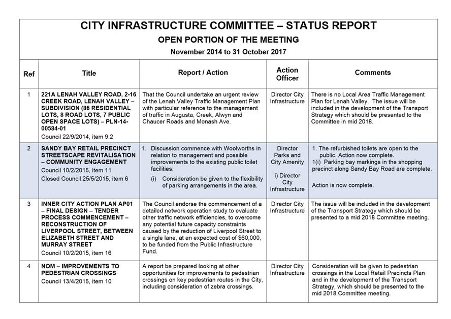
of hobart
AGENDA
City Infrastructure Committee Meeting
Open Portion
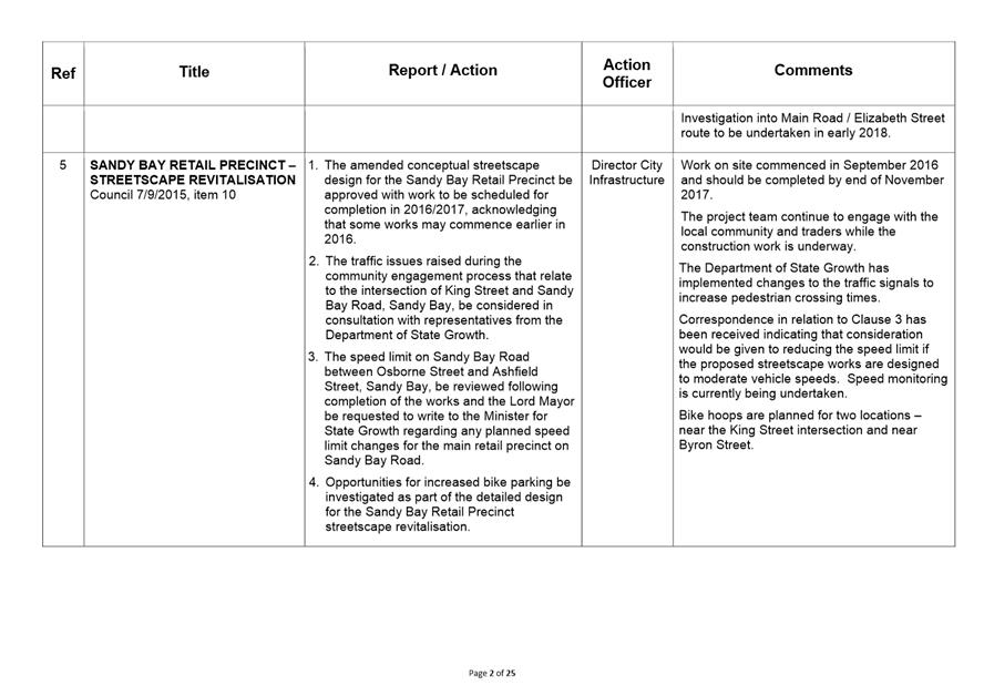
Wednesday, 22 November 2017
at 5.00 pm
Lady Osborne Room, Town Hall
City
of hobart
AGENDA
City Infrastructure Committee Meeting
Open Portion
Wednesday, 22 November 2017
at 5.00 pm
Lady Osborne Room, Town Hall
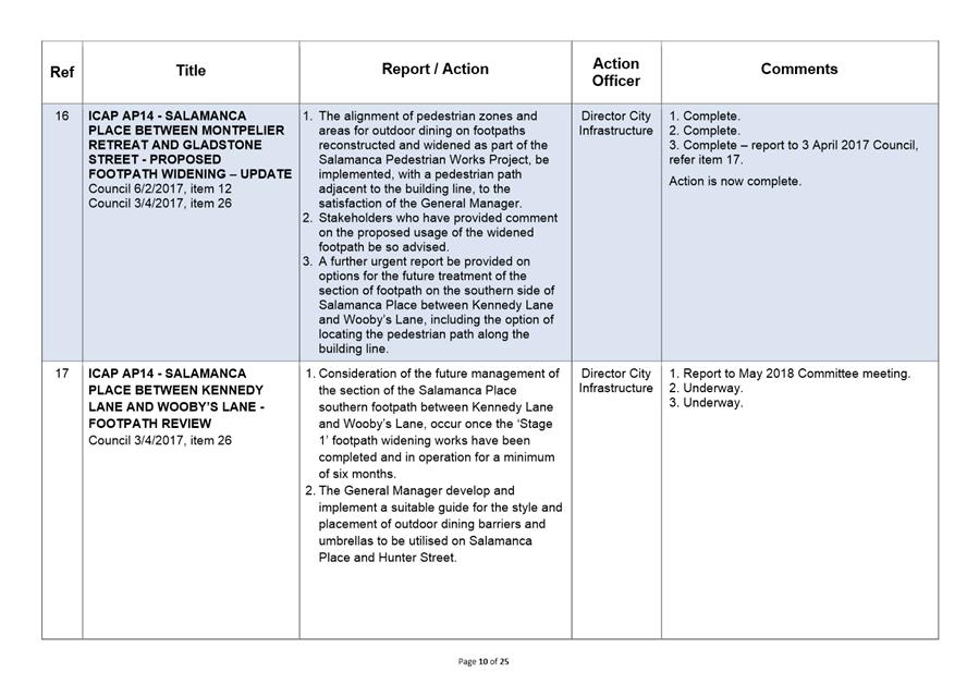
THE MISSION
Our mission is to ensure good governance of our capital City.
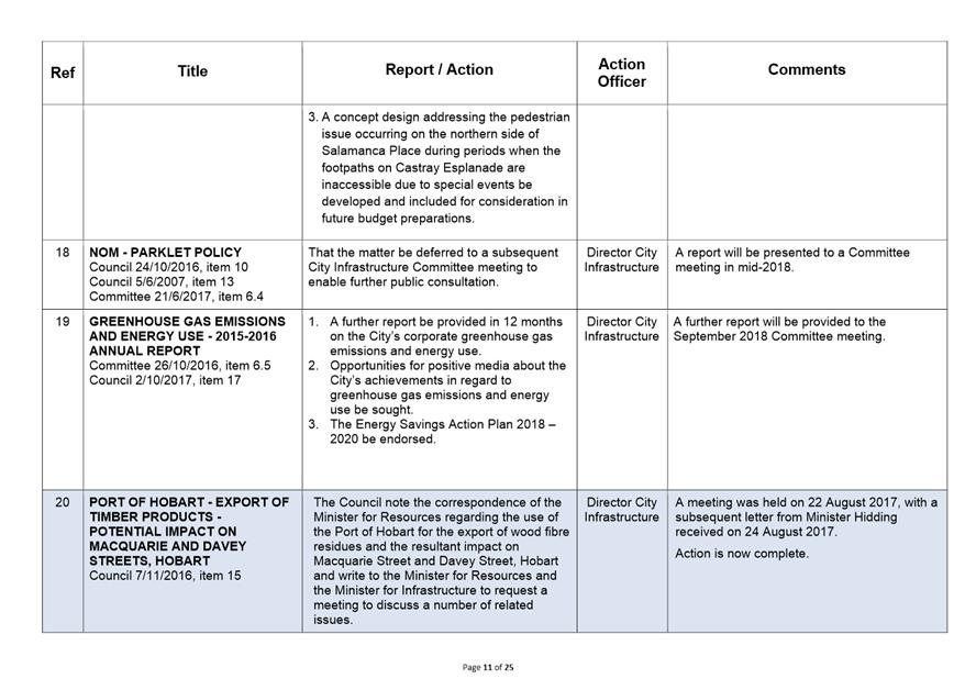
THE VALUES
The Council is:
|
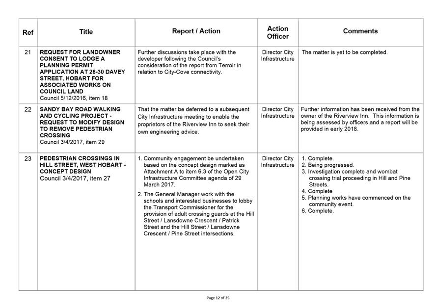
about people |
We value people – our community, our customers and colleagues. |
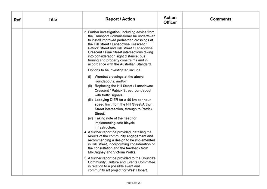
|
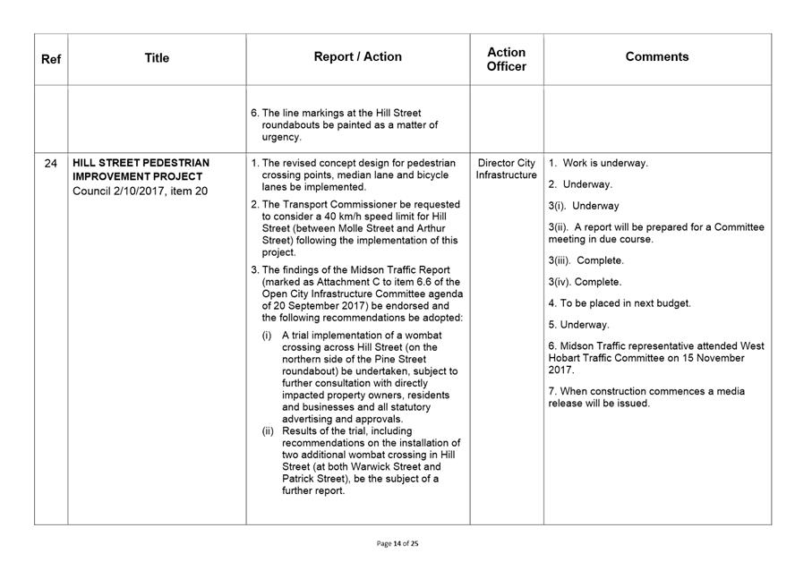
professional |
We take pride in our work. |
|
enterprising |
We look for ways to create value. |
|
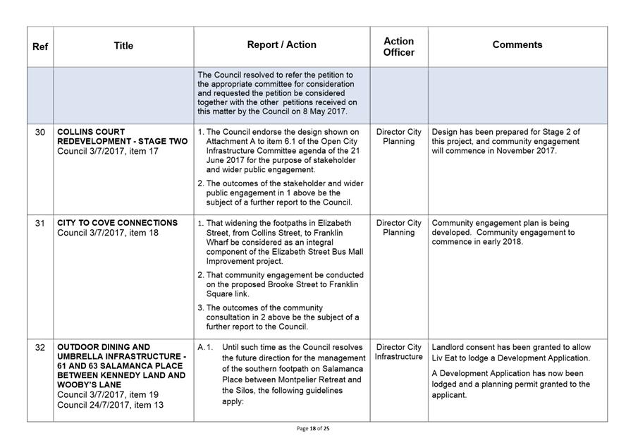
responsive |
We’re accessible and focused on service. |
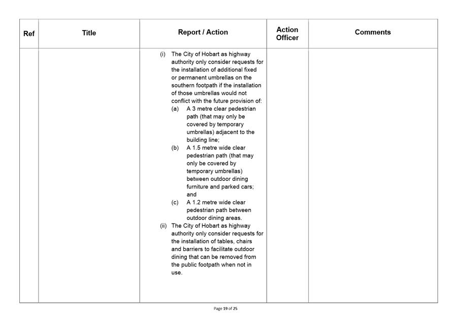
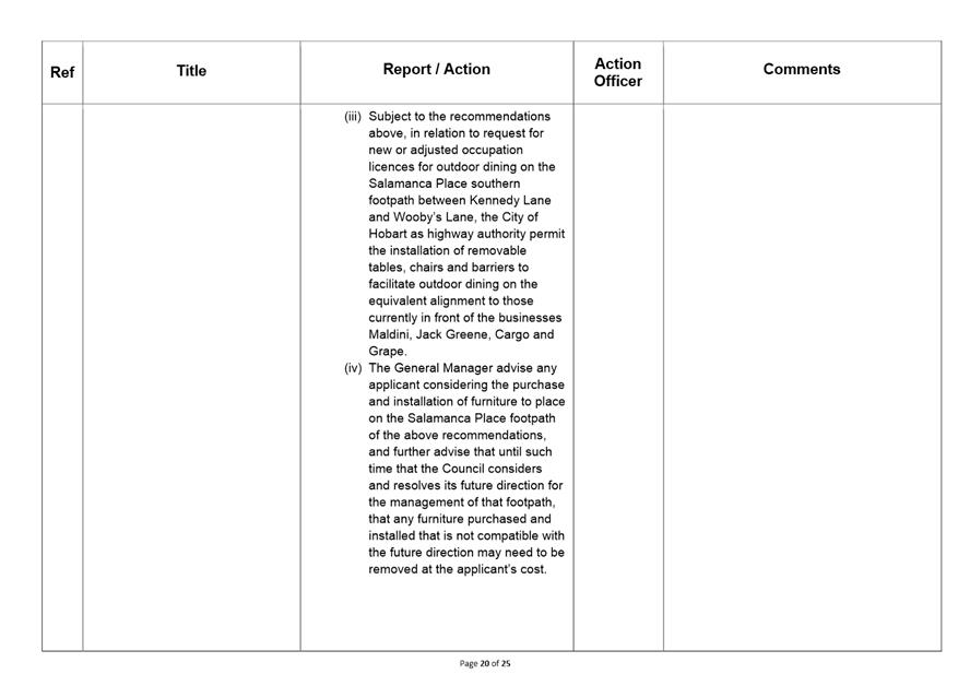
|
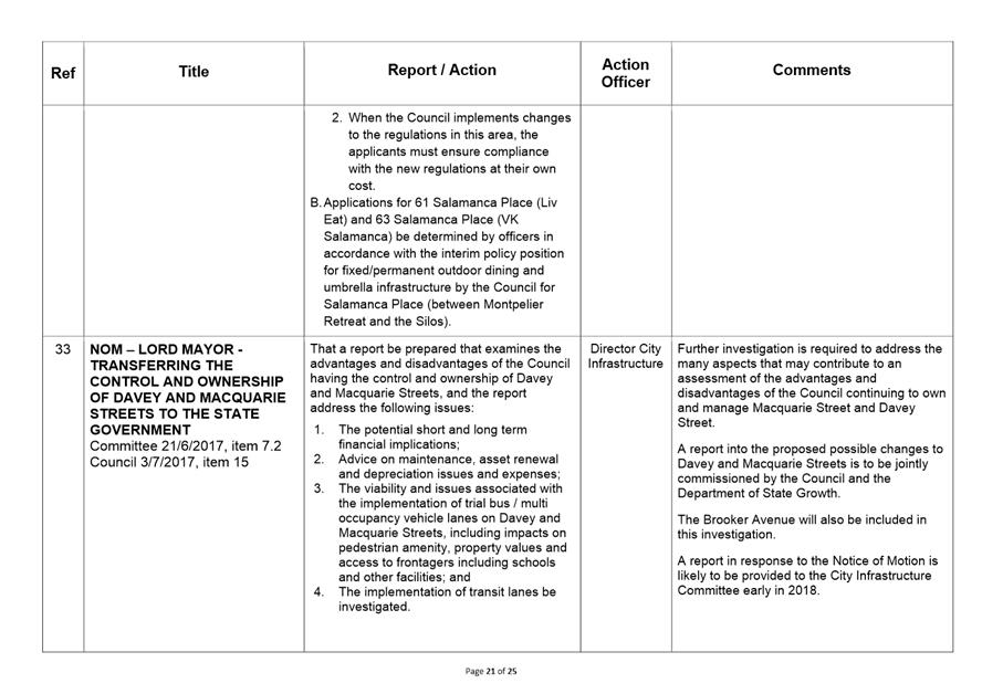
inclusive |
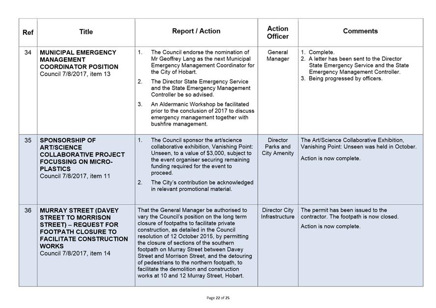
We respect diversity in people and ideas. |
|
making a difference |
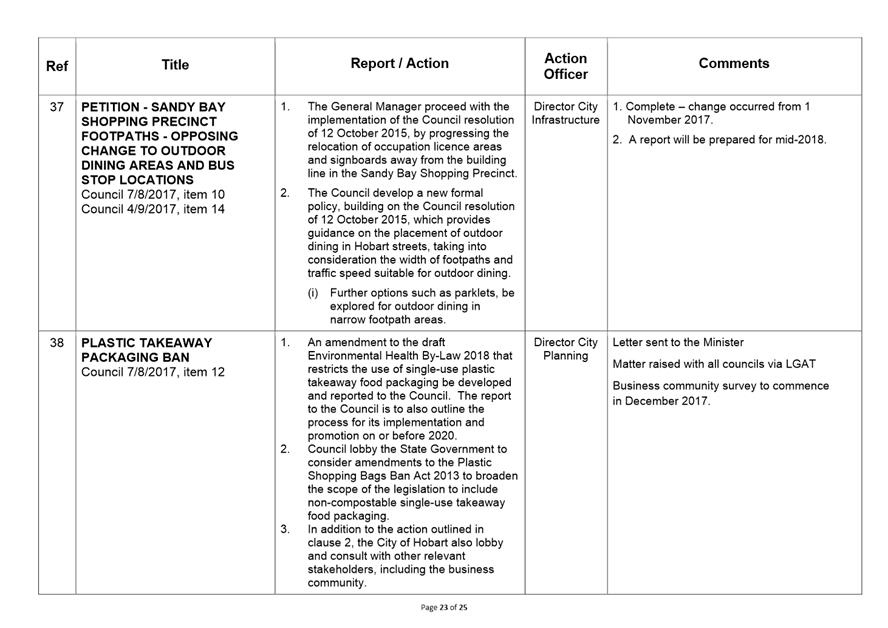
We recognise that everything we do shapes Hobart’s future. |
|
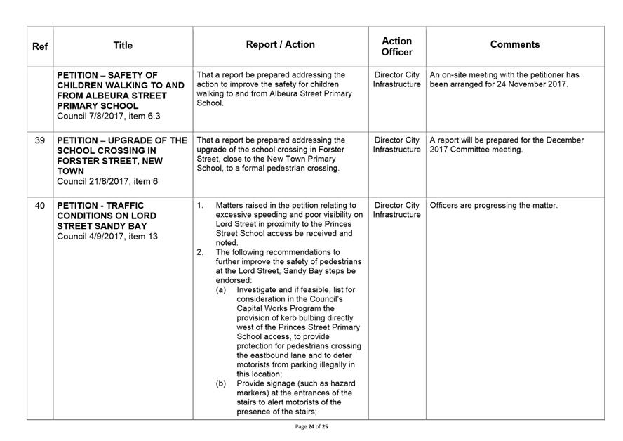
|
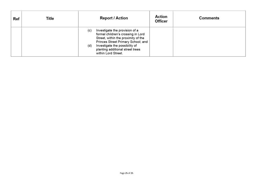
Agenda (Open Portion) City Infrastructure Committee Meeting |
Page 3 |
|
|
22/11/2017 |
|
Business listed on the agenda is to be conducted in the order in which it is set out, unless the committee by simple majority determines otherwise.
APOLOGIES AND LEAVE OF ABSENCE
1. Co-Option of a Committee Member in the event of a vacancy
3. Consideration of Supplementary Items
4. Indications of Pecuniary and Conflicts of Interest
6.1 29 Morrison Street, Hobart - Removal of Three Car Parking Spaces
6.2 McRobies Gully Waste Management Centre - Revised Landfill Rehabilitation Levy
6.3 City of Hobart Green Waste Collection Service - Outcomes
6.4 Sandy Bay Road Walking and Cycling Project - Safety and Uptake.
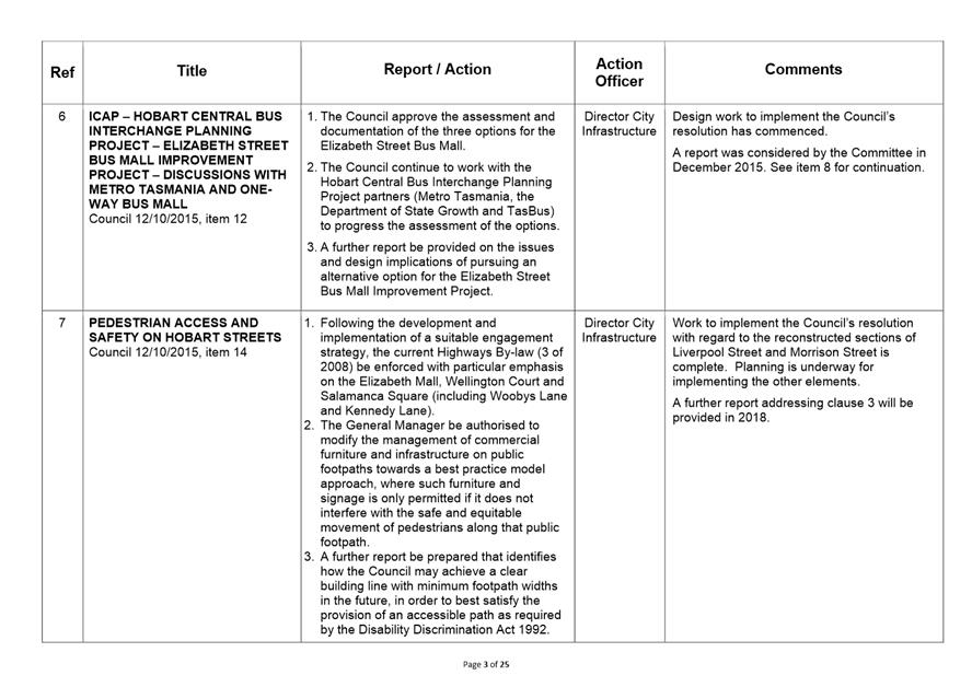
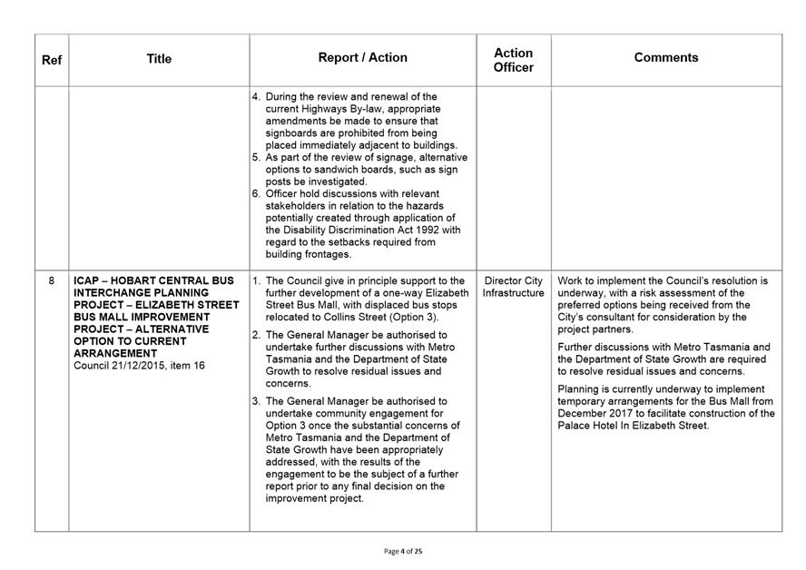
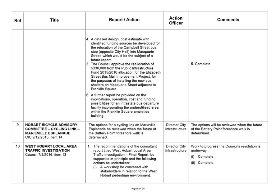
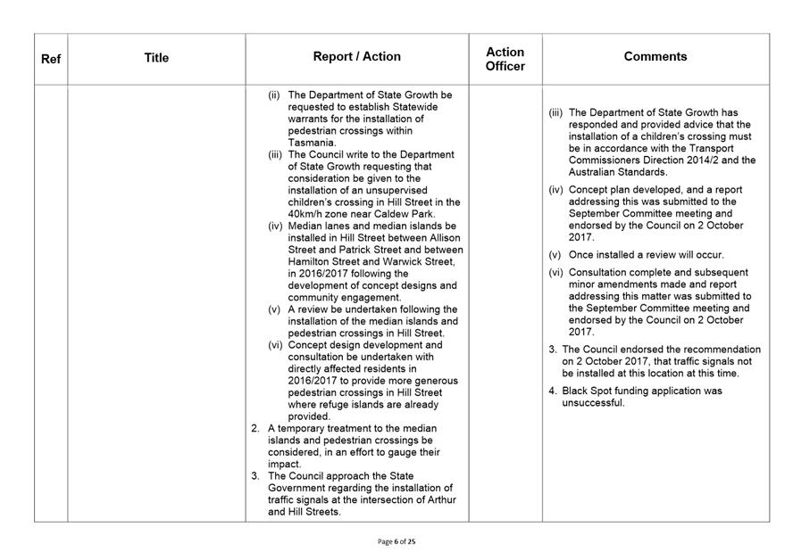
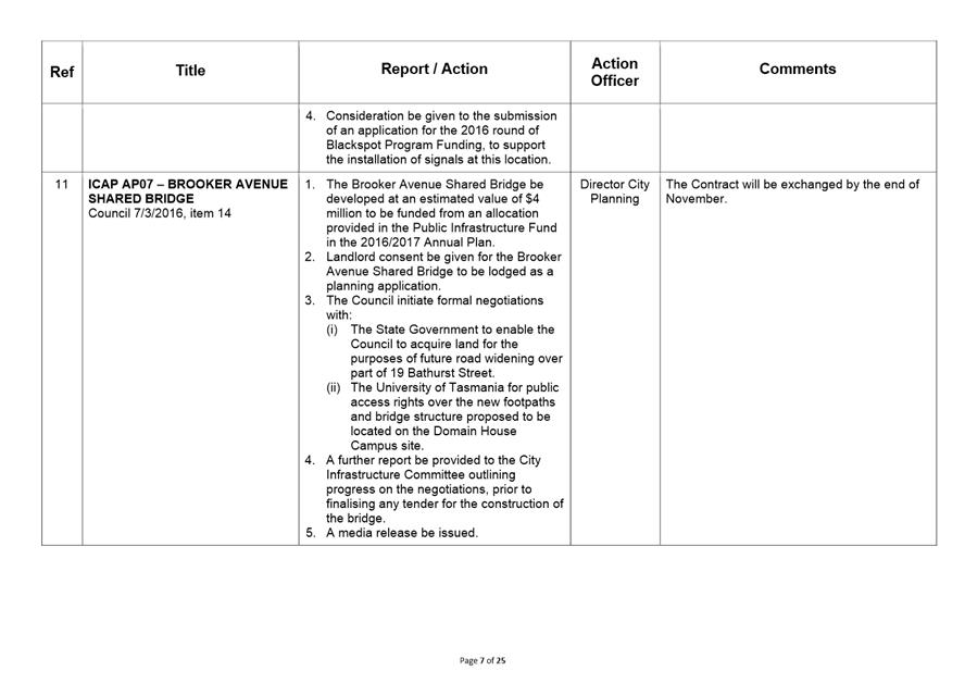
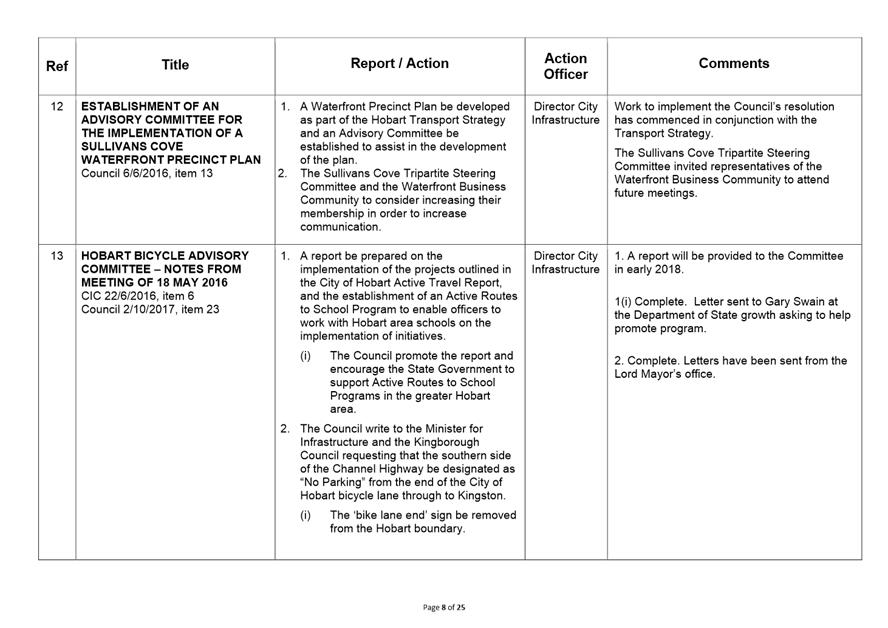
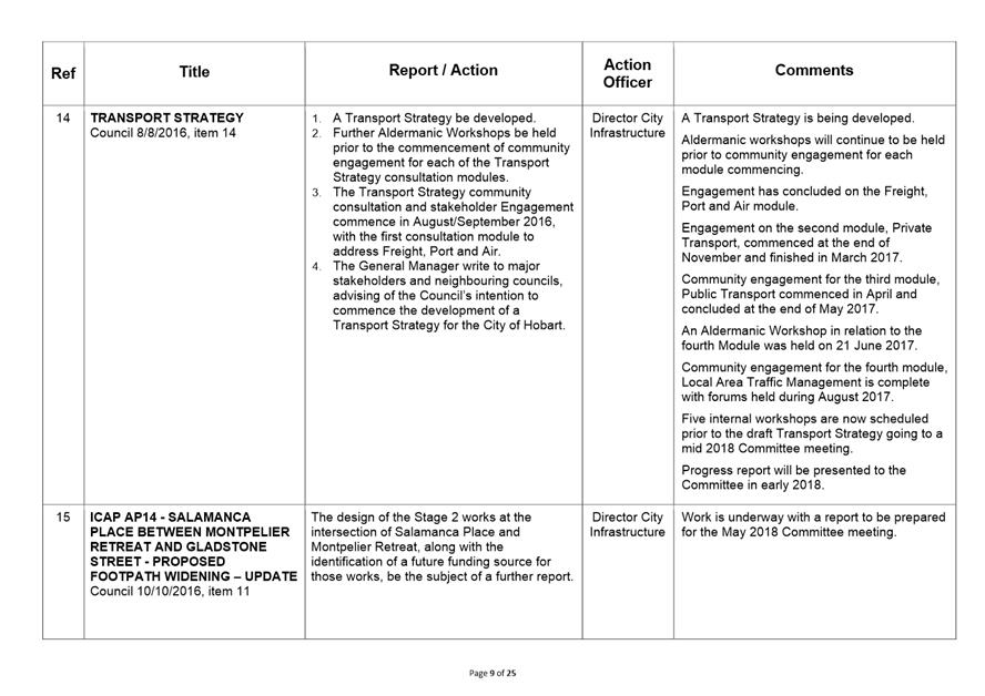
7 Committee Action Status Report
7.1 Committee Actions - Status Report
9. Closed Portion Of The Meeting
|
|
Agenda (Open Portion) City Infrastructure Committee Meeting |
Page 4 |
|
|
22/11/2017 |
|
City Infrastructure Committee Meeting (Open Portion) held Wednesday, 22 November 2017 at 5.00 pm in the Lady Osborne Room, Town Hall.
|
COMMITTEE MEMBERS Burnet (Chairman) Deputy Lord Mayor Christie Reynolds Denison Harvey
ALDERMEN Lord Mayor Hickey Zucco Briscoe Ruzicka Sexton Cocker Thomas |
Apologies: Nil.
Leave of Absence: Alderman T M Denison.
|
|
The minutes of the Open Portion of the City Infrastructure Committee meeting held on Wednesday, 20 September 2017, are submitted for confirming as an accurate record.
|
Ref: Part 2, Regulation 8(6) of the Local Government (Meeting Procedures) Regulations 2015.
|
That the Committee resolve to deal with any supplementary items not appearing on the agenda, as reported by the General Manager.
|
Ref: Part 2, Regulation 8(7) of the Local Government (Meeting Procedures) Regulations 2015.
Aldermen are requested to indicate where they may have any pecuniary or conflict of interest in respect to any matter appearing on the agenda, or any supplementary item to the agenda, which the committee has resolved to deal with.
Regulation 15 of the Local Government (Meeting Procedures) Regulations 2015.
A committee may close a part of a meeting to the public where a matter to be discussed falls within 15(2) of the above regulations.
In the event that the committee transfer an item to the closed portion, the reasons for doing so should be stated.
Are there any items which should be transferred from this agenda to the closed portion of the agenda, or from the closed to the open portion of the agenda?
|
Agenda (Open Portion) City Infrastructure Committee Meeting |
Page 6 |
|
|
|
22/11/2017 |
|
6.1 29 Morrison Street, Hobart - Removal of Three Car Parking Spaces
Memorandum of the Group Manager Project Services and the Director City Planning of 16 November 2017 and attachment.
Delegation: Committee
|
Item No. 6.1 |
Agenda (Open Portion) City Infrastructure Committee Meeting |
Page 7 |
|
|
22/11/2017 |
|
Memorandum: City Infrastructure Committee
29 Morrison Street, Hobart - Removal of Three Car Parking Spaces
Introduction
On 9 October 2017, the Council’s City Planning Committee considered a development application for the installation of outdoor dining furniture in the road reservation fronting 29 Morrison Street, Sullivans Cove.
The Council subsequently resolved at its meeting held on 23 October 2017, the following:
That the City Infrastructure Committee request an investigation into the possible removal of three car parking spaces located in front of 29 Morrison Street.
Background
The Hobart Waterfront Upgrading project was undertaken in 2016. These works required the approval of a development application prior to commencement. The application was needed as a result of changes to the kerb alignment, installation of new street furniture and changes to the footpath materials.
The original proposal sent to the Council did not include on-street parking in Morrison Street between Murray Street and Brooke Street. Instead at that time, it was proposed that this area be used as a permanent travelling lane.
On 21 December 2015 the Council, acting as planning authority, granted approval for a pedestrian and cycleway, tree removal, landscaping, roadworks and lighting at Morrison Street.
The decision of the Council was subsequently appealed to the Resource Management and Planning Appeal Tribunal by William Allison trading as Peter Johnston Ship Chandlers, the occupier of 21-25 Morrison Street.
The primary concern of Mr Allison was the removal of the on-street parking immediately adjacent to his premises and its perceived detrimental impact on the operation of his business.
To expedite a resolution, officers considered the concerns of the appellant. Officers were of the view that retaining three parking spaces outside the appellant’s premises was feasible subject to a travelling lane being put in place during the afternoon peak travelling period.
On 22 February 2016, the Council resolved to modify the road arrangements in Morrison Street so as to include three car parks between Murray Street and Brooke Street.
As a result of these changes, the proprietor of Peter Johnston Ship Chandlery agreed to withdraw his appeal.
Traffic and Safety Considerations
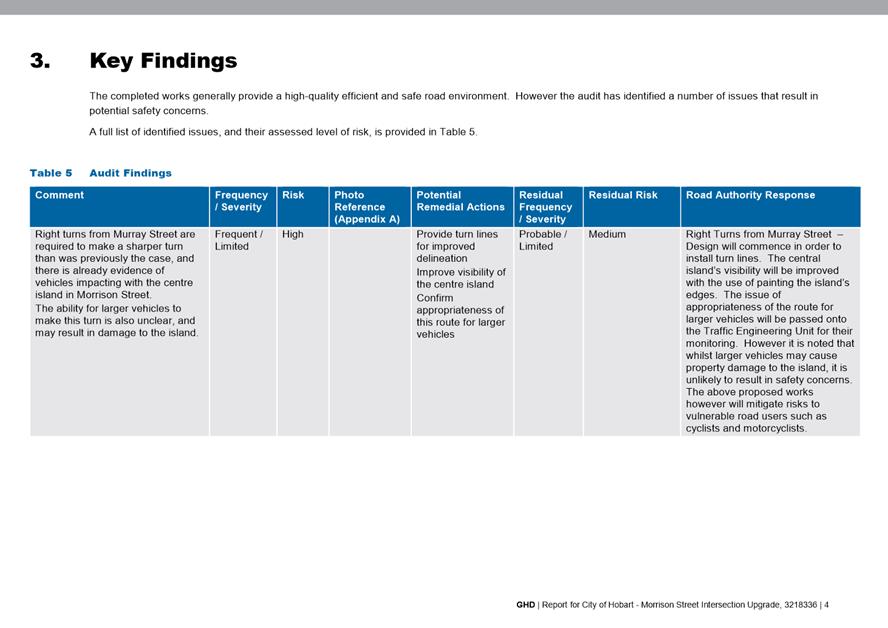
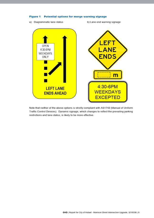
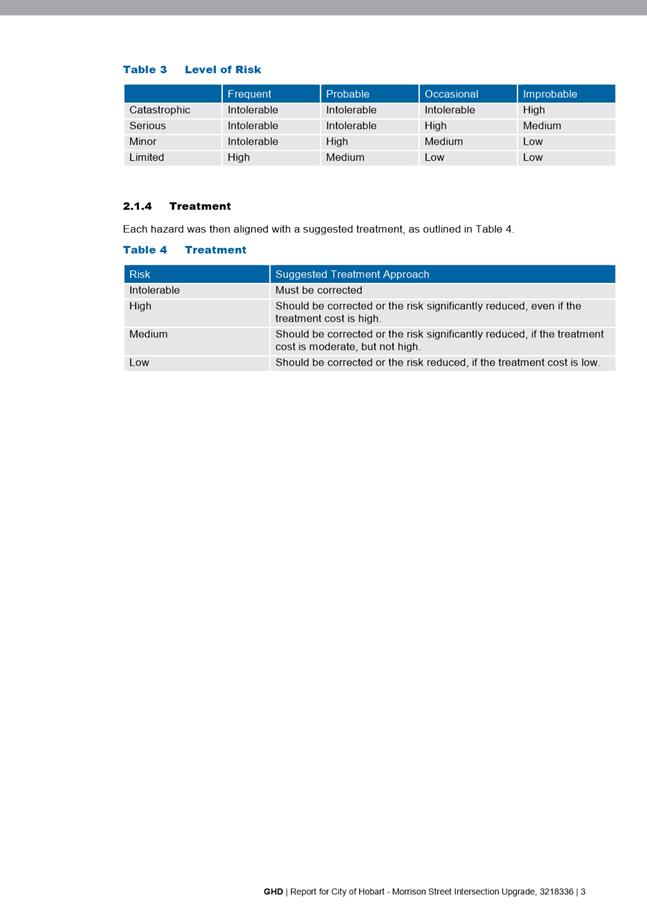
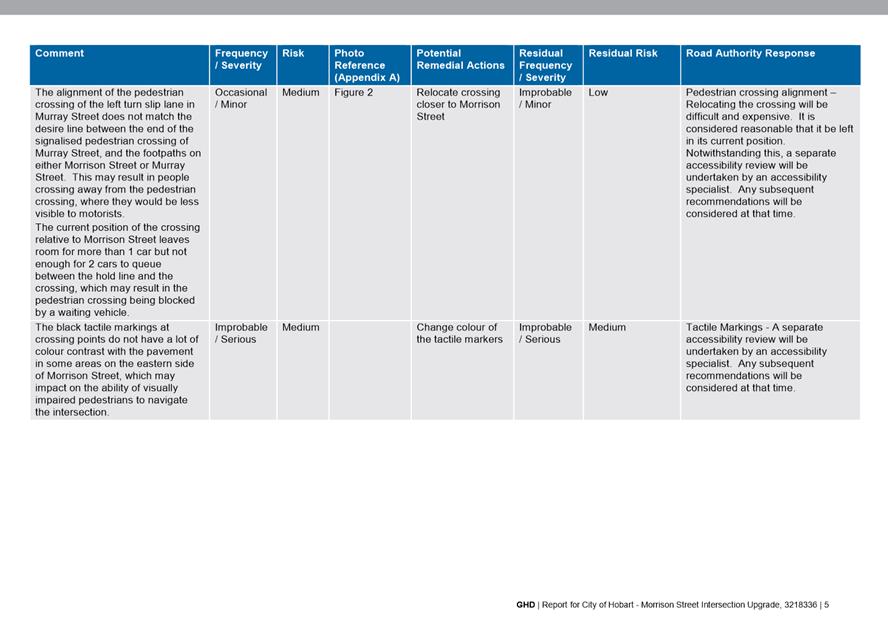
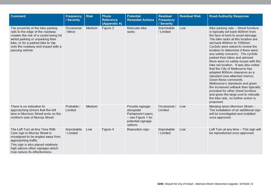
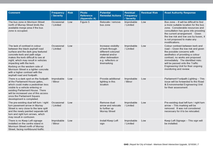
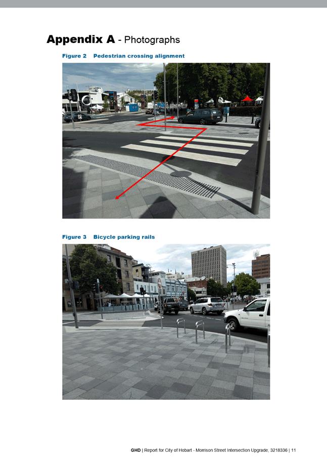
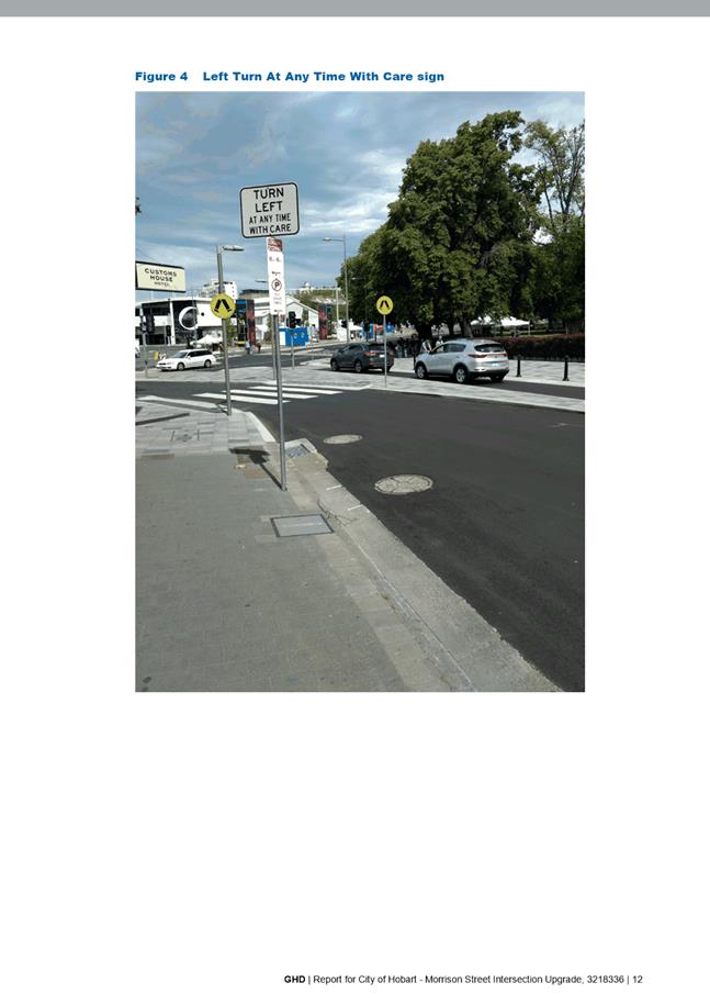
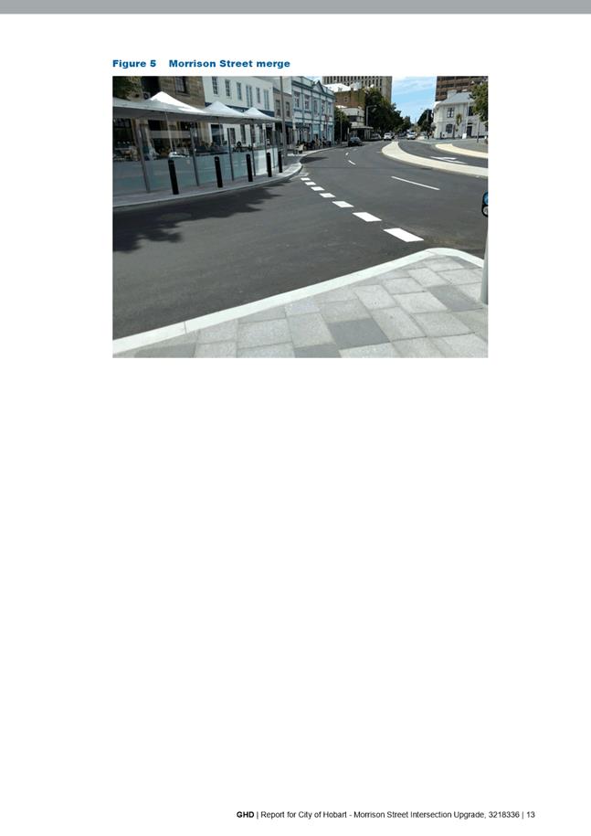
Since the installation of the car parking and completion of the project, the site has been the subject of an independent Traffic Safety Audit by engineering consultant, GHD. This audit recommended the installation of a sign advising motorists that they would need to merge due to parking being present (refer page 6 of Attachment A). This sign has since been installed. No other recommendations were made regarding this matter.
The City’s traffic engineers have advised after reviewing the Department of State Growth’s database that no crashes relevant to this matter have been reported since the works were implemented. After observing the site, reviewing the history of crashes to date and noting the safety audit prepared by GHD, no further action was considered necessary to improve safety at this location.
The City’s traffic engineers have advised that the on-street parking in this location is both reasonable and appropriate.
Discussion
Removal of the car parking is not considered necessary to address any safety concerns.
The provision of on-street parking is ultimately a matter for the Council acting as highway authority and does not fall for consideration under the provisions of the Sullivans Cove Planning Scheme 1997.
The Council’s previous decision to install these car parks will not prevent the Council, acting as highway authority, from revisiting the parking arrangements now or in the future.
Notwithstanding this, the Council has previously considered this matter and resolved to install these car parks after carefully reviewing all the opinions of the various stakeholders. It is likely there would be concerns raised from those affected if a decision was made to now remove these car parks.
Recommendation
There does not appear to be a compelling reason to remove these car parks at present.
It is recommended that the information in this memorandum be received and noted.
|
That the information contained in the memorandum titled ‘29 Morrison Street, Hobart - Removal of Three Car Parking Spaces’ of 16 November 2017, be received and noted.
|
As signatory to this report, I certify that, pursuant to Section 55(1) of the Local Government Act 1993, I hold no interest, as referred to in Section 49 of the Local Government Act 1993, in matters contained in this report.
|
Geoff Lang Group Manager Project Services |
Mark Painter Director City Infrastructure |
Date: 16 November 2017
File Reference: F17/146054; 5669918E
Attachment a: GHD
- Morrison Street Intersection Upgrade - Road Safety Audit - January 2017 ⇩ ![]()
|
Item No. 6.1 |
Agenda (Open Portion) City Infrastructure Committee Meeting - 22/11/2017 |
Page 10 ATTACHMENT a |
|
Item No. 6.1 |
Agenda (Open Portion) City Infrastructure Committee Meeting - 22/11/2017 |
Page 15 ATTACHMENT a |
|
Item No. 6.1 |
Agenda (Open Portion) City Infrastructure Committee Meeting - 22/11/2017 |
Page 20 ATTACHMENT a |

|
Item No. 6.2 |
Agenda (Open Portion) City Infrastructure Committee Meeting |
Page 28 |
|
|
22/11/2017 |
|
6.2 McRobies Gully Waste Management Centre - Revised Landfill Rehabilitation Levy
Report of the Manager Cleansing & Solid Waste and the Director Parks and City Amenity of 16 November 2017.
Delegation: Council
|
Item No. 6.2 |
Agenda (Open Portion) City Infrastructure Committee Meeting |
Page 29 |
|
|
22/11/2017 |
|
REPORT TITLE: McRobies Gully Waste Management Centre - Revised Landfill Rehabilitation Levy
REPORT PROVIDED BY: Manager Cleansing & Solid Waste
Director Parks and City Amenity
1. Report Purpose and Community Benefit
1.1. The purpose of this report is to provide a detail on the future application of the McRobies Gully Landfill Rehabilitation Levy.
1.2. At its meeting of 25 May 2015, the Council resolved inter alia that:
“The status quo remain in respect to the McRobies Gully Landfill Rehabilitation Levy until such time as the Council has considered the response from the Tasmanian Environmental Protection Authority in respect to its application for amendment to the current Environmental Protection Notice to increase the landfill profile of the McRobies Gully Landfill site”.
1.3. The required application has been approved by the Environment Protection Authority (EPA), and an Environmental Protection Notice has been issued. The approval secures the operation of the landfill until 2030.
1.4. Maintaining an active landfill until 2030 creates a significant community benefit through avoidance of costs associated with transport of waste and gate fees payable at alternative facilities. It also allows the City time to implement waste reduction measures through the Waste Management Strategy 2015-2030 to limit the residual waste required to be handled upon landfill closure.
2. Report Summary
2.1. The proposal by the City to extend the life of the McRobies Gully Landfill until 2030 has been approved by the Planning Authority, and the Environment Protection Authority.
2.2. The approval for the landfill extension has enabled detailed rehabilitation costing of what is a larger landfill area than envisioned when the original rehabilitation levy was approved in 2010. The revised liability is in the order of $2.2M in additional cost.
2.3. This report provides the option for a longer time period to recover costs associated with progressive and final rehabilitation (capping) of the landfill.
2.4. The report proposes the continued application of the McRobies Gully Landfill Rehabilitation Levy at a reduced rate of $10 per year for residential and $20 per year for commercial properties, commencing 1 July 2018 and applying this for a period ending on 30 June 2027.
|
That: 1. The McRobies Gully Landfill Rehabilitation Levy be reduced from $50 to $10 per residential property, and reduced from $100 to $20 per commercial property, commencing 1 July 2018. 2. The Levy be applied for a period ending on 30 June 2027. |
4. Background
4.1. The City implemented a McRobies Gully Landfill Rehabilitation Levy on ratepayers in 2011/12, at rate of $50 per residential and $100 per commercial property.
4.2. In 2010, it was estimated that the McRobies Gully Landfill would reach capacity in 2017. The levy was to be applied for a period of 7 years 2011/12 to 2017/18, expecting to generate $8.6M in revenue, which included an allowance for inflationary impacts over the life of the collection.
4.3. Work undertaken to prepare the Planning Application for the height increase included a detailed assessment of rehabilitation needs, enabling more accurate rehabilitation cost calculations. The new calculations also take into consideration the new permit and licence rehabilitation requirements including those relating to post closure monitoring and decommissioning.
4.4. The resulting cost calculation, with an allowance for inflation, identifying the need for a total collection of $10.8M to undertake the rehabilitation and post closure monitoring at McRobies Gully.
4.5. As of 30 June 2017 (the 6th year of the levy application), the City will have generated $7.4M in revenue, with $4.4M in works having been undertaken and $3.0M remaining in reserve.
4.6. The approval to extend the landfill has clarified rehabilitation requirements. There are additional costs associated with the increased surface area of the final profile of the landfill. There are also increased requirements associated with the rehabilitation process required by the EPA under the new EPN for the site. These result in an increased liability of $2.2M.
4.7. The City could continue
the current rate of levy collection until the additional funding is
accumulated. At the present rate that would require the continuation of the
levy for a further 2 years (ie until June 2020).
Alternatively, the City could reduce the quantum of the annual levy and extend
the period of the collection (ie through until 30 June 2027).
5. Proposal and Implementation
5.1. It is proposed to maintain the levy at its current rate until 30 June 2018, then reduce the annual amount of the levy, and apply it over a longer period.
5.2. It is proposed to;
5.2.1. Reduce the annual McRobies Gully Landfill Rehabilitation Levy from $50 to $10 per residential property, and from $100 to $20 per commercial property, per year, commencing 1 July 2018.
5.2.2. Then apply the amended Levy through to 30 June 2027.
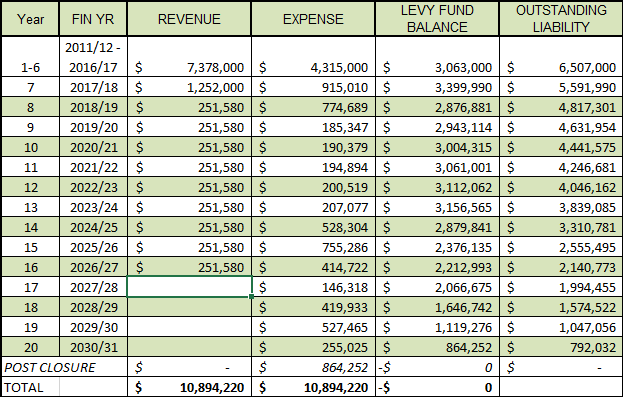
5.3. The application of the Levy at the reduced rate and longer duration will ensure that sufficient funds are available in the reserve to perform the required works each year. Table 1 details the proposed rehabilitation plan.
TABLE 1 – PROPOSED REHABILITATION PLAN –
2011/12 – 2030/31
(including Post Closure)
5.4. The proposal will result in a reduction in rates notices of $40 and $80 for residential and commercial ratepayers respectively from 1 July 2018 with rates notices to then indicate a rehab levy of $10 for residential, and $20 for commercial properties, until 30 June 2027.
5.5. Failure to account for close out costs is one of the most common issues facing current landfills. This proposal ensures that the City has accounted for all rehabilitation and post closure requirements through until 2050, and that there will be no further liability to ratepayers for the McRobies Gully Landfill once it has closed.
5.6. The calculation of the overall closure liability includes an annual increase in the rate for works of 2.5% to account for fluctuations in materials, plant and labour costs, and a $500,000 sum for installation of cut-off drains above the site.
6. Strategic Planning and Policy Considerations
6.1. The proposal relates to Goal 3 of the Strategic Plan 2015-2025, in particular Strategic Objective 3.2 – Strong Environmental Stewardship, and 3.2.6 Develop and implement an Environmental Management Plan (EMP) to underpin the continued operation of the McRobies Gully landfill operation.
6.2. A significant part of the EMP approved by the EPA relates to rehabilitation and post closure planning, and the City now has a clear, approved plan for the ongoing operation and final close out of the McRobies Gully landfill.
6.3. The Waste Management Strategy 2015-2030 includes Action 2.2 to review long term financial liabilities including post closure requirements, and Action 7.1 to secure approvals to operate the landfill until 2030.
7. Financial Implications
7.1. Funding Source and Impact on Current Year Operating Result
7.1.1. No impact.
7.2. Impact on Future Years’ Financial Result
7.2.1. For years 2018/19 to 2026/27, this will be a Levy of $10 for residential and $20 for commercial properties.
7.2.2. The Levy will raise revenue of $251,580 per year, 2018/19 to 2026/27, and raise $2.2M over that time, to be held in a dedicated reserve account, and accessed annually as required to perform rehabilitation works.
7.2.3. This additional $2.2M will fund the true costs of rehabilitation and post closure monitoring.
7.2.4. All of the financial changes contained in this report, the increased rehabilitation cost, and the levy being extended to 2026/27, but at a reduced amount, have been fully incorporated into the Council’s long term financial plan.
7.3. Asset Related Implications
7.3.1. There may be some assets created as a result of the rehabilitation program, in the form of surface water drains and infrastructure. All such assets will be added to the asset register to ensure they are insured and attract renewal funding as required.
8. Legal, Risk and Legislative Considerations
8.1. There are no legal, risk and legislative considerations associated with this report.
9. Environmental Considerations
9.1. Rehabilitating the
landfill will address a range of environmental impacts. Increased capping will
result in less water penetrating the landfill, therefore producing less
leachate requiring treatment.
It will also increase methane capture, which reduces greenhouse gas
emissions and generates green electricity.
The rehabilitation of the landfill is a requirement of the Environment
Protection Notice issued for the site by the EPA.
10. Social and Customer Considerations
10.1. Increasing the life of the landfill extends the availability of the landfill for the City’s customers, and the City’s services. The extension also provides time to implement waste reduction programs and work towards zero waste to landfill by 2030.
11. Marketing and Media
11.1. There may be marketing and media actions required to advise the community of the change in levy structure.
12. Community and Stakeholder Engagement
12.1. Significant community and stakeholder engagement was undertaken in relation to the extension of the landfill life and long term rehabilitation needs during the preparation of the Development Proposal and Environmental Management Plan for the McRobies Gully Landfill, and the Waste Management Strategy 2015-2030.
13. Delegation
13.1. This matter is delegated to the Council.
As signatory to this report, I certify that, pursuant to Section 55(1) of the Local Government Act 1993, I hold no interest, as referred to in Section 49 of the Local Government Act 1993, in matters contained in this report.
|
David Holman Manager Cleansing & Solid Waste |
Glenn Doyle Director Parks and City Amenity |
Date: 16 November 2017
|
Item No. 6.3 |
Agenda (Open Portion) City Infrastructure Committee Meeting |
Page 34 |
|
|
22/11/2017 |
|
6.3 City of Hobart Green Waste Collection Service - Outcomes
Memorandum of the Manager Cleansing & Solid Waste and the Director Parks and City Amenity of 16 November 2017 and attachment.
Delegation: Committee
|
Item No. 6.3 |
Agenda (Open Portion) City Infrastructure Committee Meeting |
Page 35 |
|
|
22/11/2017 |
|

Memorandum: City Infrastructure Committee
City of Hobart Green Waste Collection Service - Outcomes
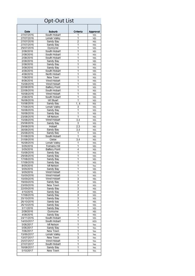
The City’s Fortnightly Kerbside Residential Green Waste Collection Service commenced in 1 May 2016, to approximately 12,500 residences.
With the scheme determining certain properties automatically receive the service, several requests were received to opt-out of the scheme.
The Council, at its meeting held on 6 June 2016 resolved to delegate to the General Manager the authority to allow properties to opt out of the scheme should be demonstrate the following:
1. Property does not produce green waste, or on site composting;
2. Financial burden;
3. Alternative kerbside service used;
4. Medical reasons.
To date a total of 67 properties have been assessed and granted approval to opt-out of the scheme (57 in 2016, 10 to date in 2017), with 5 of residences meeting more than one criteria.
The Council decision of June 2016 further sort information on those residences granted approval under the above criteria to opt-out of the scheme (Attachment A).
During the same period 1,300 additional residences have elected to voluntarily join the scheme.
Action 4.1 of the
City’s Waste Management Strategy 2015-2030 details
‘Implement a fortnightly green waste kerbside collection service, to
appropriate tenements’.
To date 3,000 tonnes of green waste has been diverted from landfill into mulch/compost through the service, 25% more than originally estimated.
FREE ENTRY WEEKEND
The introduction of the service has seen the amount of green waste delivered to the McRobies Gully Waste Management Centre during the City’s ‘free entry weekends’ decrease by around 40%, from an average of 77 tonnes prior to the kerbside service, down to an average of 45 tonnes.
The receipt of green waste over the ‘free entry weekends’ appears to have plateaued at 45 tonnes per event, indicating it is still a required service for the Hobart community. Its role in residences mitigating bushfire hazards in removing combustible further assists the community and the City with this strategic risk.
|
That the information contained in the memorandum titled ‘City of Hobart Green Waste Collection Service – Outcomes’ of 16 November 2017 be received and noted.
|
As signatory to this report, I certify that, pursuant to Section 55(1) of the Local Government Act 1993, I hold no interest, as referred to in Section 49 of the Local Government Act 1993, in matters contained in this report.
|
David Holman Manager Cleansing & Solid Waste |
Glenn Doyle Director Parks and City Amenity |
Date: 16 November 2017
File Reference: F17/149878
Attachment a: List
by Suburb - Residence Opt Out ⇩ ![]()
|
Item No. 6.3 |
Agenda (Open Portion) City Infrastructure Committee Meeting - 22/11/2017 |
Page 37 ATTACHMENT a |
|
Agenda (Open Portion) City Infrastructure Committee Meeting |
Page 38 |
|
|
|
22/11/2017 |
|
6.4 Sandy Bay Road Walking and Cycling Project - Safety and Uptake
Report of the Manager Traffic Engineering and the Director City Infrastructure of 16 November 2017.
Delegation: Committee
|
Item No. 6.4 |
Agenda (Open Portion) City Infrastructure Committee Meeting |
Page 39 |
|
|
22/11/2017 |
|
REPORT TITLE: Sandy Bay Road Walking and Cycling Project - Safety and Uptake
REPORT PROVIDED BY: Manager Traffic Engineering
Director City Infrastructure
1. Report Purpose and Community Benefit
1.1. This report responds to previous Council resolutions regarding the Sandy Bay Road Walking and Cycling Project, specifically providing information regarding usage and uptake.
1.2. There is benefit to the community in continuing to monitor the usage and ongoing safety of all users on Sandy Bay Road, to ensure that any issues can be identified and addressed as required (for both this project and other similar projects into the future).
2. Report Summary
2.1. The three stages of the Sandy Bay Road Walking and Cycling Project are now complete.
2.1.1. Stage 1 of the project was completed in February 2014, and saw the installation of on-road bicycle lanes along both sides of Sandy Bay Road between Derwentwater Avenue and Fisher Avenue.
2.1.2. Stage 2 included an off-road shared path along the eastern side of Sandy Bay Road between Marieville Esplanade and Derwentwater Avenue (including a “toucan” crossing at the Drysdale Avenue traffic signals) and was completed in October 2014.
2.1.3. Stage 3 of the project was completed in February 2017 and includes on-road bicycle lanes along both sides of Sandy Bay Road between Wayne Avenue and the Kingborough boundary.
2.2. There has been a steady increase in cycling numbers along Sandy Bay Road since completion of the Stage 1 and Stage 2 sections of the Sandy Bay Walking and Cycling Project.
2.3. The installation of permanent bicycle counters on both Stage 1 and Stage 2 of the project will further assist in assessing the use of the cycling facilities provided by this scheme. While data cannot be extracted from the permanent counters this year due to issues relating to access and faulty installations, the issues are expected to be resolved and data will be available in future years.
2.4. Crash data has been extracted from the Department of State Growth database for the five year period to 31 March 2017.
2.4.1. In the 12 months to 31 March 2017, there have been three crashes reported on the Stage 1 section of Sandy Bay Road (between Derwentwater Avenue and Fisher Avenue). There were no crashes reported in the 12 month period that involved a vulnerable road user.
2.4.2. There have been three crashes reported on the Stage 2 section of Sandy Bay Road (between Marieville Esplanade and Derwentwater Avenue) in the 12 month period to 31 March 2017. In the two years to 31 March 2017, there were no crashes reported that involved vulnerable road users.
2.4.3. No crash data has been included for the Stage 3 section of Sandy Bay Road (between Wayne Avenue and the Kingborough boundary) as the works were completed towards the end of the reporting period.
2.5. Apart from a slightly elevated crash rate in 2014‑15, there has not been a statistically significant increase or decrease in crashes on Stage 1. On Stage 2, there appears to be a visible decrease when comparing the results from 2014‑15 to 2016‑17 with a reduction from 12 crashes to 3 crashes.
2.6. Monitoring of the cycling uptake and safety relating to the Sandy Bay Road Walking and Cycling project will continue on an ongoing basis and the City’s officers will continue to respond to any safety issues on this (and other roads) as they arise.
|
That the report of the Manager Traffic Engineering and the Director City Infrastructure titled ‘Sandy Bay Road Walking and Cycling Project – Safety and Uptake’ be received and noted.
|
4. Background
4.1. Sandy Bay Road between Marieville Esplanade and the southern municipal boundary with Kingborough was identified as part of the Principal Bicycle Network (adopted by Council in 2008) and also in the 2009 Hobart Regional Arterial Bicycle Network Plan. The Sandy Bay Road Walking and Cycling Project delivers cycling infrastructure on this part of the designated arterial bicycle network.
4.2. The Sandy Bay Road Walking and Cycling Project is now complete with the Stages 1 and 2 completed in 2014 and Stage 3 completed this year.
4.2.1. Stage 1 saw the installation of on-road bicycle lanes along both sides of Sandy Bay Road between Derwentwater Avenue and Fisher Avenue and was completed in February 2014.
The speed limit in this section of Sandy Bay Road was reduced from 60km/h to 50km/h when this stage of the project was completed.
4.2.2. Stage 2 included the completion of an off-road shared path along the eastern side of Sandy Bay Road between Marieville Esplanade and Derwentwater Avenue, including a “toucan” crossing (where both pedestrians and bike riders can cross together) at the Drysdale Avenue traffic signals and was completed in October 2014.
4.2.3. Stage 3 of the project (on Sandy Bay Road between Wayne Avenue and the Kingborough boundary (Cartwright Reserve)) included on-road bicycle lanes along both sides of the road was completed in February 2017 included the installation of on-road bicycle lanes.
The speed limit in this section of Sandy Bay Road was also reduced from 60km/h to 50km/h when this stage of the project was completed.
4.3. At its meeting held on 11 August 2014, the Council resolved the following:
That: 1. The installation of an in-bound bicycle counter on Sandy Bay Road be approved, at an estimated cost of $3,000 to be funded from the existing Sustainable Transport budget allocation contained within the Traffic Strategy and Projects Function in the 2014/2015 Annual Plan.
2. The further surveying of users of the Sandy Bay Road, on-road bicycle facilities, be referred to the Hobart Bicycle Advisory Committee for comment.
3. The City of Hobart continue to participate in the Hobart Counts annual commuter bicycle survey, at an estimated cost of $3,750, to be funded from the Sustainable Transport budget allocation within the Traffic Strategy and Projects Function in the 2014/2015 Annual Plan.
4.4. Permanent counter sites have been established. Unfortunately data cannot be extracted from the counters due to issues below. It is expected that the counters will be functioning in future years.
4.4.1. A counter (located in Section 2) is unable to accurately provide reliable data due to issues with the installation of the loops and will need to be reinstalled or replaced. As such, no data has been collected from this permanent counter site but it will provide useful data on usage and uptake of cycling into the future. The replacement counter loops are expected to be installed within the next 12 months.
4.4.2. The control box of the permanent counter installed just south of Derwentwater Avenue could not be accessed to download the volume data. Once access issues have been resolved then data on the usage and uptake of cycling can be obtained for future analysis.
4.5. The City of Hobart (as one of the Cycling South member Councils) has been collecting annual data on the number of riders using various routes around Greater Hobart. These counts have been done annually on the first Tuesday in March since 2010 and help monitor trends and growth in cycling. The “Super Tuesday” survey records the number of cyclists at the identified locations for the two hour period between 7am and 9am.
5. Usage and Uptake
5.1. Figure 1, below, shows the number of cyclists recorded at the intersection of Marieville Esplanade / Earl Street / Sandy Bay Road and also at the intersection of Churchill Avenue / Sandy Bay Road collected during the “Super Tuesday” surveys.
5.1.1. It can be seen that at both of the Sandy Bay Road locations there has been a steady increase in cyclists recorded in 2017 compared to the 2016 and 2015 results at the Marieville Esplanade / Earl Street / Sandy Bay Road.
5.1.2. There appears to be a large drop in cycle numbers in 2011 which is not consistent with data from previous or future years.
5.1.3. The data also indicates that cyclist numbers are gradually increasing across the eight years at the Churchill Avenue / Sandy Bay Road but at a slower rate than at the Marieville Esplanade / Earl Street / Sandy Bay Road site.
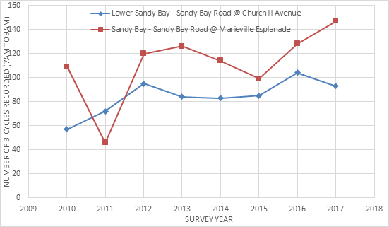
FIGURE 1 – Cycle numbers by site (Super Tuesday Counts), Sandy Bay Road only
5.2. Figure 2, below, shows a comparison of the Marieville Esplanade / Earl Street / Sandy Bay Road intersection and the Churchill Avenue / Sandy Bay Road intersection, an aggregation of all Sandy Bay sites and all Hobart sites. It should be noted that the sum of all Sandy Bay sites and all Hobart sites has been provided in the graphs for the purpose of identifying a trend over the eight years (from 2010) and does not reflect the actual numbers of cyclists (as cyclists may have been counted at multiple sites during their journey). It can be seen that the steady increase in cycling numbers from 2016 to 2017 is consistent across all sites and not limited to the Sandy Bay Road locations.
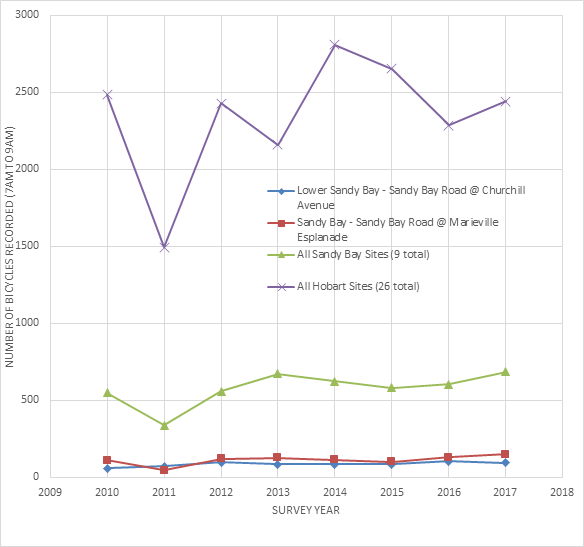
FIGURE 2 – Cycle numbers by site (Super Tuesday Counts), various sites
6. Road Safety Outcomes – Stage 1
6.1. Crash data has been extracted from the Department of State Growth’s crash database for the five years to 31 March 2017 for the section of Sandy Bay Road between Derwentwater Avenue and Fisher Avenue, which represents the section of works completed as Stage 1 of the Sandy Bay Road Walking and Cycling project.
6.2. A total of 37 crashes were reported over the five year period, with 3 crashes reported in the 12 month period to 31 March 2017 (contributing to a total of 23 crashes since the completion of the bicycle lanes in this section of Sandy Bay Road). Figure 3 shows the number of crashes each year, categorised by severity. The number of crashes reported in the last year are lower in comparison to the crashes that have occurred in previous years (notwithstanding the slightly increased crash rate in 2014-2015). The severity of crashes reported in the last 12 months are consistent with previous years, with one injury crash (serious injury) reported and the remaining crashes resulting in property damage only crashes.
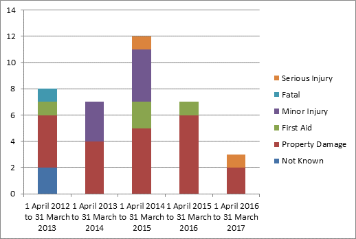
FIGURE 3 – Severity of crashes by year (Cycleway Stage 1)
6.3. Figure 4 shows a comparison of the type of vehicles involved in the crashes. The majority of crashes involved light or heavy vehicles only. Approximately 10% of crashes involved a vulnerable road user (such as a pedestrian, cyclist or motorcyclist).
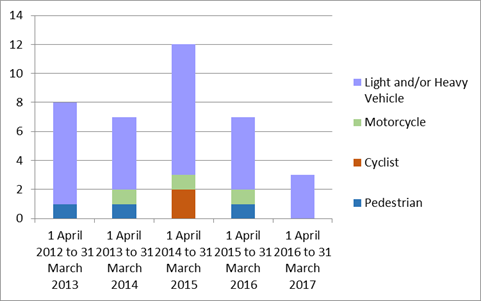
FIGURE 4 – Crashes by vehicle type by year
6.4. In the period 1 April 2016 to 31 March 2017 there were no crashes involving a vulnerable road users and all reported crashes involved only light or heavy vehicles.
7. Road Safety Outcomes – Stage 2
7.1. Crash data has been extracted from the Department of State Growth’s crash database for the five years to 31 March 2017 for the section of Sandy Bay Road between Marieville Esplanade and Derwentwater Avenue which represents the section of works completed as Stage 2 of the Sandy Bay Road Walking and Cycling project.
7.2. A total of 46 crashes were reported over the five year period. Figure 5 shows the number of crashes recorded each year, categorised by severity.
7.3. It can be seen that reported crashes have decreased in 2016‑17 with three crashes reported, a decrease from the average of 10.75 crashes per year in the previous four years. The severity of crashes reported in the year to 31 March 2017 has also decreased, with all crashes resulting in property damage only.
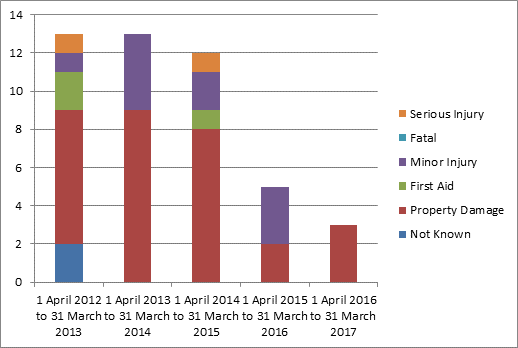
FIGURE 5 – Severity of crashes by year (Cycleway Stage 2)
7.4. Figure 6 shows a comparison of the type of vehicle involved in the crashes. In the years 2013‑14, 2015‑16 and 2016‑17 there were no crashes recorded that involved vulnerable road users.
7.5. There were two crashes relating to a vulnerable road user occurred in the past 5 years. In the two years to 31 March 2017, there have been no crashes involving vulnerable road users.
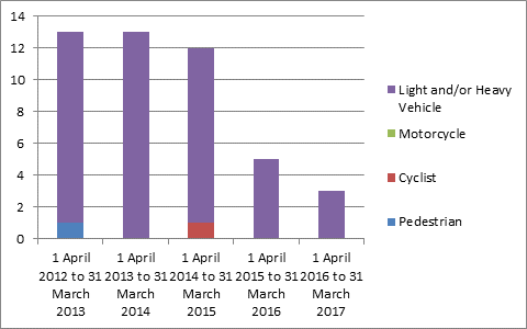
FIGURE 6 –Crashes by vehicle type by year (Cycleway Stage 2)
8. Road Safety Outcomes – Stage 3
8.1. As Stage 3 was completed in February 2017 there is little data available for this reporting period (to 31 March 2017). However, in the period 1 March 2017 to 31 October 2017 there has been one bicycle crash reported – where a vehicle failed to giveway to a cyclist at the Beach Road intersection in dark and wet conditions. The crash resulted in property damage only.
8.2. A full review of the crash statistics for Stage 3 will commence in 2018.
9. Proposal and Implementation
9.1. That monitoring of the cycling uptake and safety in regard to the Sandy Bay Road Walking and Cycling project continue on an ongoing basis and that the City’s officers continue to respond to any safety issues on this (and other roads) as they arise.
10. Strategic Planning and Policy Considerations
10.1. The following Capital City Strategic Plan 2015-2025 references are relevant in considering this matter:
10.1.1. “Goal 2 - Urban Management” and particularly the following sub-objectives of “Strategic Objective 2.1 – A fully accessible and connected city environment”:
2.1.2 Enhance transport connections within Hobart;
2.1.3 Identify and implement infrastructure improvements to enhance road safety; and
2.1.6 Implement the Principal Bicycle Network.
11. Financial Implications
11.1. Funding Source and Impact on Current Year Operating Result
11.1.1. Not Applicable.
11.2. Impact on Future Years’ Financial Result
11.2.1. Not Applicable.
11.3. Asset Related Implications
11.3.1. Not Applicable.
12. Legal, Risk and Legislative Considerations
12.1. Ongoing monitoring of safety along the length of the Sandy Bay Road Walking and Cycling project will ensure that any trends are identified and issues rectified as necessary. Any issues identified in the early stages of the project can be addressed in future stages and on other cycling projects throughout the City of Hobart.
13. Delegation
13.1. This matter is delegated to the Committee.
As signatory to this report, I certify that, pursuant to Section 55(1) of the Local Government Act 1993, I hold no interest, as referred to in Section 49 of the Local Government Act 1993, in matters contained in this report.
|
Angela Moore Manager Traffic Engineering |
Mark Painter Director City Infrastructure |
Date: 16 November 2017
File Reference: F17/147970; R0820/26
|
Agenda (Open Portion) City Infrastructure Committee Meeting |
Page 49 |
|
|
|
22/11/2017 |
|
A report indicating the status of current decisions is attached for the information of Aldermen.
REcommendation
That the information be received and noted.
Delegation: Committee
|
Item No. 7.1 |
Agenda (Open Portion) City Infrastructure Committee Meeting - 22/11/2017 |
Page 50 ATTACHMENT a |
|
|
Agenda (Open Portion) City Infrastructure Committee Meeting |
Page 76 |
|
|
22/11/2017 |
|
Section 29 of the Local Government (Meeting Procedures) Regulations 2015.
File Ref: 13-1-10
An Alderman may ask a question without notice of the Chairman, another Alderman, the General Manager or the General Manager’s representative, in line with the following procedures:
1. The Chairman will refuse to accept a question without notice if it does not relate to the Terms of Reference of the Council committee at which it is asked.
2. In putting a question without notice, an Alderman must not:
(i) offer an argument or opinion; or
(ii) draw any inferences or make any imputations – except so far as may be necessary to explain the question.
3. The Chairman must not permit any debate of a question without notice or its answer.
4. The Chairman, Aldermen, General Manager or General Manager’s representative who is asked a question may decline to answer the question, if in the opinion of the respondent it is considered inappropriate due to its being unclear, insulting or improper.
5. The Chairman may require a question to be put in writing.
6. Where a question without notice is asked and answered at a meeting, both the question and the response will be recorded in the minutes of that meeting.
7. Where a response is not able to be provided at the meeting, the question will be taken on notice and
(i) the minutes of the meeting at which the question is asked will record the question and the fact that it has been taken on notice.
(ii) a written response will be provided to all Aldermen, at the appropriate time.
(iii) upon the answer to the question being circulated to Aldermen, both the question and the answer will be listed on the agenda for the next available ordinary meeting of the committee at which it was asked, where it will be listed for noting purposes only.
|
|
Agenda (Open Portion) City Infrastructure Committee Meeting |
Page 77 |
|
|
22/11/2017 |
|