City
of hobart
AGENDA
Parks and Recreation Committee Meeting
Open Portion
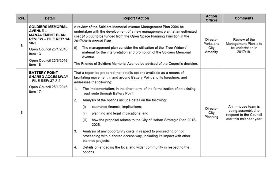
Thursday, 10 August 2017
at 5.00 pm
Lady Osborne Room, Town Hall
City
of hobart
AGENDA
Parks and Recreation Committee Meeting
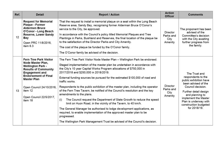
Open Portion
Thursday, 10 August 2017
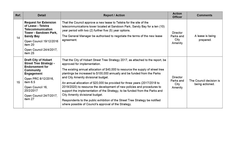
at 5.00 pm
Lady Osborne Room, Town Hall
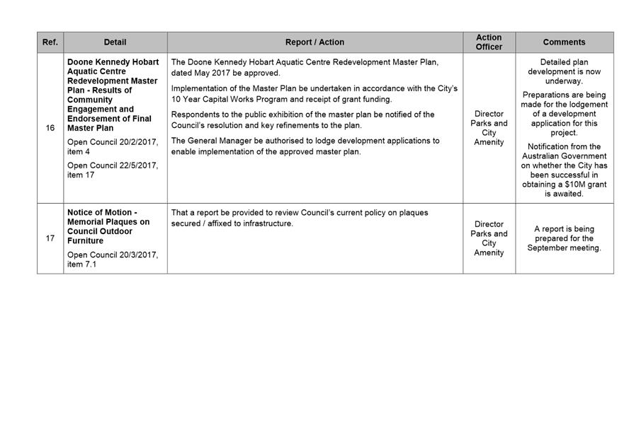
THE MISSION
Our mission is to ensure good governance of our capital City.
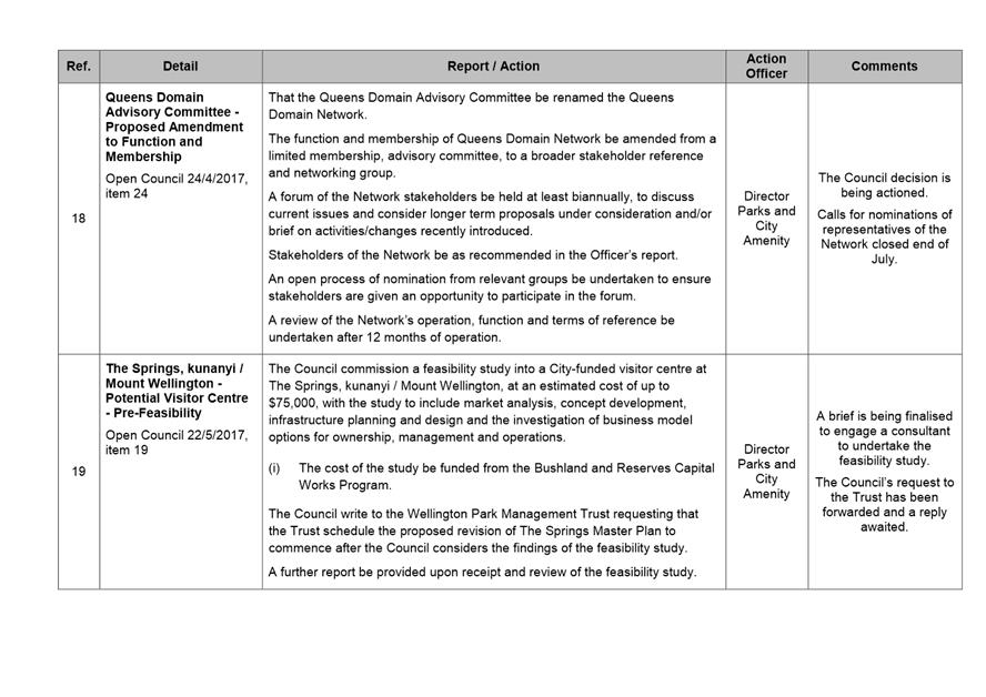
THE VALUES
The Council is:
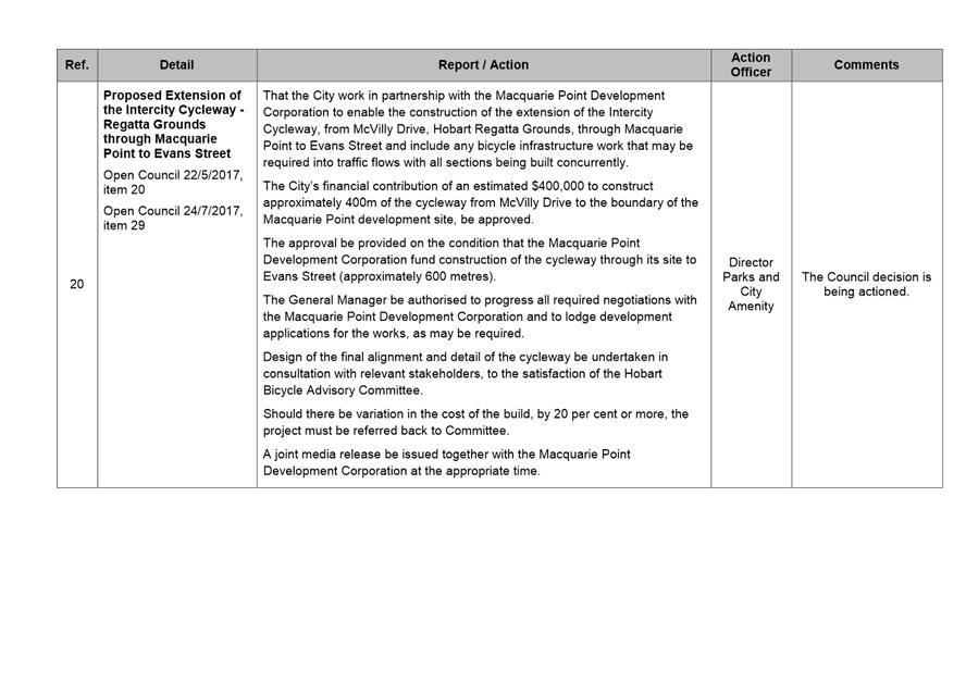
|
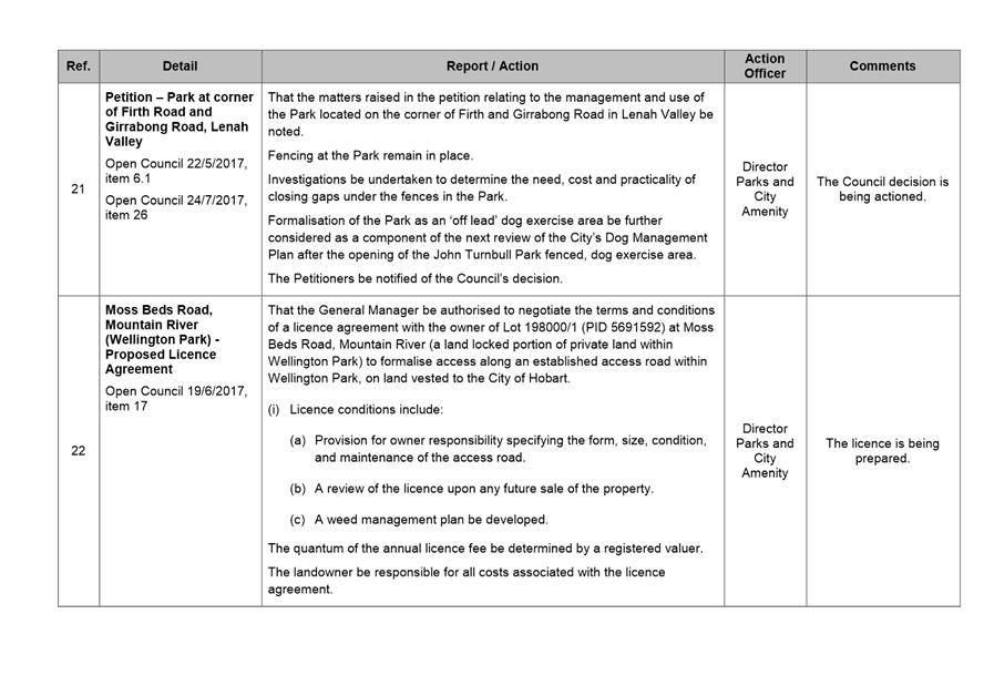
about people |
We value people – our community, our customers and colleagues. |
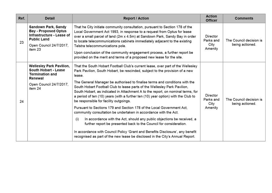
|
professional |
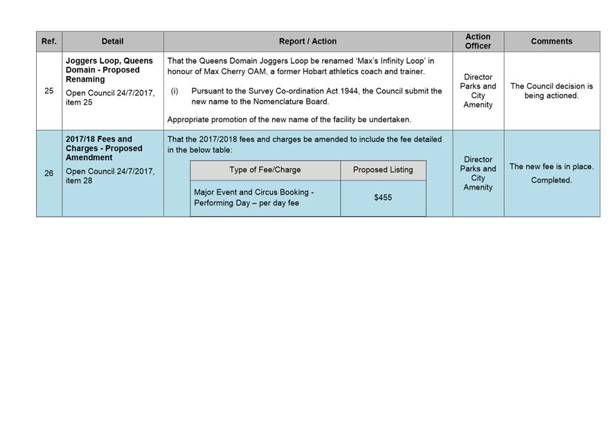
We take pride in our work. |
|
enterprising |
We look for ways to create value. |
|
responsive |
We’re accessible and focused on service. |
|
inclusive |
We respect diversity in people and ideas. |
|
making a difference |
We recognise that everything we do shapes Hobart’s future. |
|
|
Agenda (Open Portion) Parks and Recreation Committee Meeting |
Page 3 |
|
|
10/8/2017 |
|
Business listed on the agenda is to be conducted in the order in which it is set out, unless the committee by simple majority determines otherwise.
APOLOGIES AND LEAVE OF ABSENCE
1. Co-Option of a Committee Member in the event of a vacancy
3. Consideration of Supplementary Items
4. Indications of Pecuniary and Conflicts of Interest
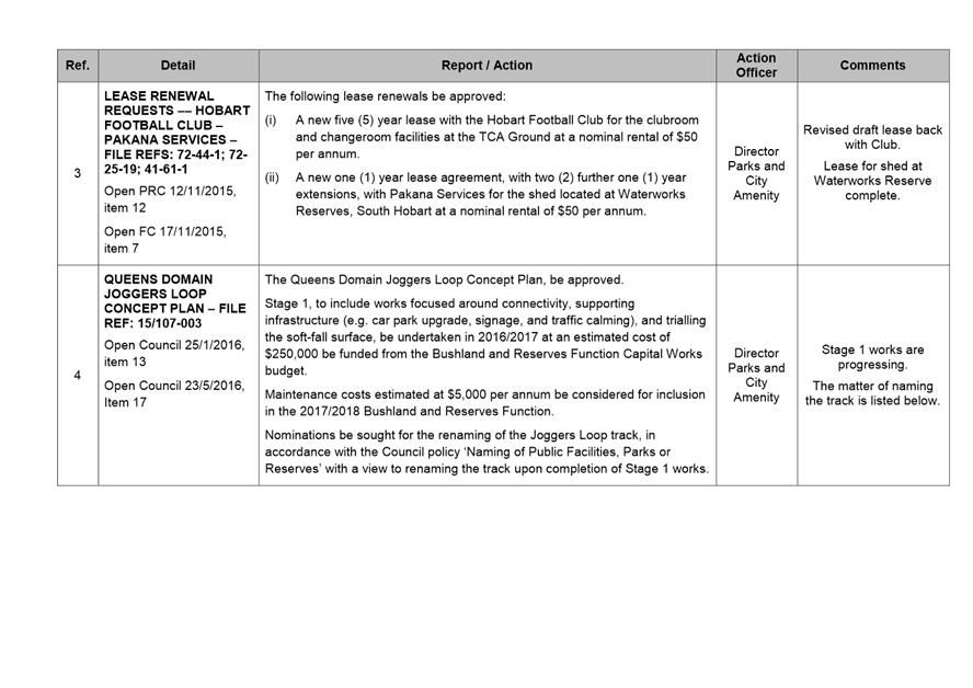
6.1 Bushfire Management 2017/2018
7 Committee Action Status Report
7.1 Committee Actions - Status Report
9. Closed Portion Of The Meeting
|
|
Agenda (Open Portion) Parks and Recreation Committee Meeting |
Page 4 |
|
|
10/8/2017 |
|
Parks and Recreation Committee Meeting (Open Portion) held Thursday, 10 August 2017 at 5.00 pm in the Lady Osborne Room, Town Hall.
|
COMMITTEE MEMBERS Reynolds (Chairman) Briscoe Ruzicka Sexton Harvey
ALDERMEN Lord Mayor Hickey Deputy Lord Mayor Christie Zucco Burnet Cocker Thomas Denison |
Apologies: Nil.
Leave of Absence: Alderman J R Briscoe. Alderman W F Harvey.
|
|
The minutes of the Open Portion of the Parks and Recreation Committee meeting held on Thursday, 13 July 2017, are submitted for confirming as an accurate record.
|
Ref: Part 2, Regulation 8(6) of the Local Government (Meeting Procedures) Regulations 2015.
|
That the Committee resolve to deal with any supplementary items not appearing on the agenda, as reported by the General Manager.
|
Ref: Part 2, Regulation 8(7) of the Local Government (Meeting Procedures) Regulations 2015.
Aldermen are requested to indicate where they may have any pecuniary or conflict of interest in respect to any matter appearing on the agenda, or any supplementary item to the agenda, which the committee has resolved to deal with.
Regulation 15 of the Local Government (Meeting Procedures) Regulations 2015.
A committee may close a part of a meeting to the public where a matter to be discussed falls within 15(2) of the above regulations.
In the event that the committee transfer an item to the closed portion, the reasons for doing so should be stated.
Are there any items which should be transferred from this agenda to the closed portion of the agenda, or from the closed to the open portion of the agenda?
|
Agenda (Open Portion) Parks and Recreation Committee Meeting |
Page 6 |
|
|
|
10/8/2017 |
|
6.1 Bushfire Management 2017/2018
File Ref: F17/93823
Report of the (Acting) Team Leader Fire and Biodiversity and the (Acting) Director Parks and City Amenity of 4 August 2017 and attachments.
Delegation: Council
|
Item No. 6.1 |
Agenda (Open Portion) Parks and Recreation Committee Meeting |
Page 7 |
|
|
10/8/2017 |
|
REPORT TITLE: Bushfire Management 2017/2018
REPORT PROVIDED BY: (Acting) Team Leader Fire and Biodiversity
(Acting) Director Parks and City Amenity
1. Report Purpose and Community Benefit
1.1. This report addresses a range of issues relating to the City’s Bushfire Management Program as listed below.
1.1.1. Review and proposed replacement of the City’s strategic framework for bushfire management operations.
1.1.2. Adoption of new State Government guidelines for fuel breaks and program of works to rectify defects in City’s fuel break network.
1.1.3. Outcome of the 2016/2017 bushfire hazard reduction program and the proposed program for 2017/2018.
2. Report Summary
2.1. The Parks and Recreation Committee at its meeting held on 13 July 2017, considered the City’s management of bushfire whereat the matter was deferred to allow Aldermen the opportunity to attend an onsite visit to bushfire management areas and to allow a briefing to be held.
2.2. Site visits and subsequent briefing was made available to Aldermen on Tuesday 1 August.
2.3. Accordingly the issue of bushfire management is resubmitted.
2.4. City’s Strategic Framework for Bushfire Management
2.4.1. The City’s strategic framework for bushfire management is due for review. This includes the City’s existing Fire Management Strategy and reserve bushfire management plans.
2.4.2. The main drivers for the review include:
· The existing City of Hobart Fire Management Strategy having been substantively implemented;
· Many of the City’s existing reserve bushfire management plans nearing the end of their useful life;
· The need to align the City’s priorities and programs with the outcomes from the Greater Wellington Range Bushfire Mitigation Strategy, currently in preparation by the Tasmania Fire Service; and
· The changed bushfire management operational context resulting from the establishment of the TFS Fuel Reduction Unit.
2.4.3. The review is proposed to be initiated in 2018 and include replacement of the existing framework with a single, strategic and over-arching bushfire management policy encompassing all City-owned or managed bushland.
2.4.4. The new strategic fire management policy would be supported and operationalised by the development of map-based annual bushfire management operating plans which would prescribe annual fire management works programs, including fire trail and fuel break construction and maintenance, and planned burning.
2.5. Bushland-Urban Interface Fuel Break Network
2.5.1. An assessment of the City’s bushland-urban interface fuel break network using new State Government guidelines and on-line calculator for the design and construction of fuel breaks has confirmed the majority of the City’s network is adequate.
2.5.2. Some
deficiencies have been identified where rectification work is required involving
extensions to some existing breaks and construction of a number of new breaks.
The total area of fuel break improvement is
approximately 10ha which represents an increase in the fuel break network of
almost 30%.
2.5.3. Community and stakeholder response was generally positive to the construction of a number of pilot new and extended fuel breaks undertaken between March and June 2017.
2.5.4. It is proposed that the new guidelines be adopted as the City’s standard with implementation of the identified network rectification works be progressively undertaken with commencement 2017/2018.
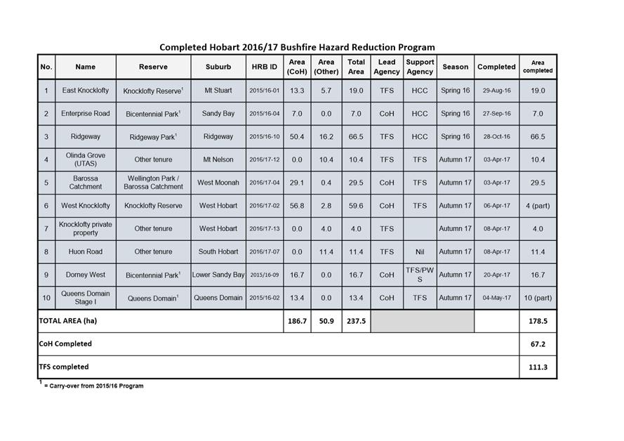
2.6. Bushfire Hazard Reduction Program
2.6.1. Ten
planned hazard reduction burns, encompassing a total area of approximately
180ha, were conducted during 2016/2017.
Seven of the burns, with a combined area of 128ha,
included City-owned or managed bushland.
2.6.2. A
program of fifteen fuel reduction burns comprising all or part the City’s
bushland estate is currently planned for the spring and autumn seasons of
2017/2018.
Of the total planned area of approximately 317ha, 231ha
is City bushland estate with the balance being private and State owned
bushland.
|
That: 1. A formal review of the City’s existing bushfire management strategic framework, including the City of Hobart Fire Management Strategy and all reserve bushfire management plans be undertaken in 2018/2019, overseen by an inter-divisional steering group. (i) The new strategic fire management policy would be supported and operationalised by the development of map-based annual bushfire management operating plans which would prescribe annual fire management works programs, including fire trail and fuel break construction and maintenance, and planned burning. (ii) The current draft Knocklofty, McRobies, Ridgeway and Waterworks Reserves Bushfire Management Plan not be separately finalised but be incorporated within the proposed new framework documents. 2. The State Government’s new Fuel Break Guidelines (2016) and on-line calculator be adopted as the City’s standard for the design and construction of fuel breaks along the bushland-urban interface, except for new development sites where AS3959-2009 Construction of buildings in bushfire prone areas would apply. 3. A fuel break improvement program be commenced in 2017/2018 to rectify deficiencies in the existing City bushland estate fuel break network in dry forest areas, identified by recent assessment using the new State Government guidelines and on-line calculator. (i) Community engagement be undertaken with owners of neighbouring properties to negotiate cooperative treatment of private property to complement fuel break improvement works undertaken on adjoining City bushland estate. 4. City Officers consider further the application of the Fuel Break Guidelines in wet forest areas, which includes Fern Tree, including undertaking community engagement on the potential implementation of the guidelines, legal and risk implications for the City and the treatment of fuels on private land. 5. The upgrade to the City’s Fire Trail Network continue through 2017/2018. 6. The completed 2016/2017 and planned 2017/2018 bushfire hazard reduction programs, summarised in Attachments D-G of the report, be noted.
|
4. Background
4.1. Strategic Bushfire Management Framework
4.1.1. The City’s bushfire management strategic framework requires review and renewal, including the existing fire management strategy and reserve bushfire management plans.
4.2. Bushfire Management Strategy
4.2.1. The City’s existing Bushfire Management Strategic Framework comprises the City of Hobart Fire Management Strategy and five reserve bushfire management plans.
4.2.2. The
Fire Management Strategy was adopted in 2014 with a planned life of 5 years, to
2019.
The Strategy is a ‘high’ level and
‘cross-division’ document which details the principles and a range
of strategies to guide management of the City’s bushfire risk.
4.2.3. Progress
in implementing the Strategy was reported to the Council on 21 November 2016.
It was noted that the majority of the Strategy’s actions have been
completed or are established and on-going.
It was resolved that a review of the Strategy be
brought forward to 2018.
4.3. Reserve Bushfire Management Plans
4.3.1. Bushfire management field operations in the City are guided by reserve bushfire management plans (RBMP).
4.3.2. These plans detail fire management activities required to mitigate fire risks for protecting life and property, whilst avoiding or minimising adverse impact on biodiversity, cultural heritage and social values.
4.3.3. Currently five RBMPs are in place encompassing most, but not all, bushland owned or managed by the City; namely:
· Ridgeway Park – Waterworks Reserves Fire management Plan (2003);
· Knocklofty Reserve McRobies Gully Fire Management Plan (2005);
· Wellington Park Fire Management Strategy (2006);
· Queens Domain Fire Management Plan (2008); and
· Bicentennial Park – Porter Hill Fire Management Plan (2014).
4.3.4. Aside
from a number of relatively small, linear bushland reserves (e.g. Haldane
Reserve, Wellesley Park), the most significant bushland block not currently
subject to a RBMP is the City’s landholdings in the Barossa Catchment at
Lenah Valley.
This area comprises approximately 112ha, the majority
(82%) of which is situated within the Glenorchy local government area.
4.3.5. The existing reserve bushfire management plans have a planned life of 15 years and existing plans range in age from 3 to 14 years.
4.3.6. The
two oldest plans, Ridgeway–Waterworks and Knocklofty-McRobies have
recently been reviewed and a new draft consolidated plan prepared.
The Council resolved at its meeting of 21 November 2016
to defer consideration of public exhibition and finalisation of the new plan
pending determination of the Council’s position on adoption of the State
Government’s new Fuel Break Guidelines: Guidelines for the design of
fuel breaks in the urban-rural interface (2016) and associated on-line
calculator.
4.4. Tasmania Fire Service Preparing Bushfire Mitigation Strategy for Greater Wellington Range
4.4.1. A
review of the Wellington Park Fire Management Strategy has recently been
initiated by the Wellington Park Management Trust (WPMT).
This review has been paused pending the outcome of a collaborative bushfire
mitigation planning project for the Greater Wellington Range initiated by the
Tasmania Fire Service (TFS).
4.4.2. The
TFS has engaged a contractor to prepare an over-arching, broad-scale bushfire
risk mitigation strategy for the Greater Wellington Range, incorporating the
eastern slopes and adjoining lands of kunanyi/Mt Wellington within Hobart and
Glenorchy local government areas.
This strategy, in essence, will confirm at a strategic
level, fire risk management priorities across all land tenures over the area,
and provide a region-level strategic framework within which finer-scale,
operational level detail planning of fire risk mitigation operations are
conducted.
4.4.3. This project is being overseen by a steering committee comprising representation from TFS, WPMT, City of Hobart, Glenorchy City Council, and the Parks and Wildlife Service.
4.5. State Government Establishment of Fuel Reduction Unit
4.5.1. The
operational context for bushfire management in the Hobart region has changed in
the last two years with the State Government establishment of the Bushfire Fuel
Reduction Unit within the TFS.
The Unit is focused on strategic bushfire risk mitigation across all land
tenures in the state and has significantly increased the capacity to plan and
conduct planned burning operations.
4.5.2. For Hobart, in collaboration with the City, this has meant more and larger burns being conducted and increased areas of private and other non-City bushland incorporated within planned burns.
4.6. The City’s Bushfire Management Strategic Framework
4.6.1. As detailed in this report, a review of the City’s Bushfire Management Framework will be undertaken in 2018. It is expected that this review will result in the replacement of the existing framework with a single, strategic and over-arching bushfire management policy encompassing all City-owned or managed bushland, including landholdings outside the local government boundary in Glenorchy and Kingborough.
4.6.2. The
new strategic document will detail the City’s rationale, policies,
principals, and priorities underpinning bushfire management operations on the
City’s bushland estate.
It will include:
· Bushfire ignition source management;
· Construction and management of fire trails and fuel breaks;
· Fuel reduction by burning and mechanical means;
· Bushfire incident preparedness and response capability;
· Interagency cooperation;
· Fire operations staff competency levels;
· Fire resourcing (equipment and personnel) capacity; and
· Ecological monitoring and management.
4.6.3. The new strategic fire management policy would be supported and operationalised by the development of map-based annual bushfire management operating plans which would prescribe annual fire management works programs, including fire trail and fuel break construction and maintenance, and planned burning.
4.6.4. Each
operating plan is to include all built, cultural (Aboriginal and historic)
heritage and environmental (including management units, fire history,
vegetation communities and significant biodiversity) attributes relevant to
decision making for bushfire management field operations, and prescribe the
annual works program (including fire trail and fuel break construction and
maintenance, and planned burning).
The data is to be maintained and annually updated on the corporate geographic
information system and presented in large-scale map-based format.
4.6.5. The
proposed framework is consistent with that used for the new draft Knocklofty,
McRobies, Ridgeway and Waterworks Reserves Bushfire Management Plan.
Much of this draft document is suitable to be directly
incorporated within the proposed new bushfire management strategic
framework.
As such, this draft plan would not be required to be
separately finalised but would be incorporated within the new framework
documents.
4.6.6. All existing reserve fire management plans, excluding that for Wellington Park, would be replaced by the proposed new framework.
4.6.7. An inter-divisional steering group complemented by other specialist staff as necessary will be established to initiate and oversee the review process.
4.7. Bushland-Urban Interface Fuel Break Network
4.7.1. The bushland-urban interface (where houses adjoin bushland) is where the bushfire risk to life and property is greatest. These areas may encompass both private and public land.
4.7.2. The City has established fuel breaks (also known as fire breaks or asset protection zones), along the interface with City-owned or managed bushland.
4.7.3. Within
the breaks, vegetation has been selectively removed, both horizontally and
vertically, creating a buffer between houses and fire-prone vegetation where
fuels are significantly reduced and maintained at very low levels.
They provide a degree of protection from bushfire and allow access for fire
response and hazard reduction burning operations.
4.7.4. The City’s existing network of fuel breaks has been created over several decades and based on the prevailing design principles and rule-of-thumb specifications.
4.7.5. New guidelines and an on-line calculator for the design of fuel breaks were publicly released by the State Government in late 2016.
4.7.6. The
guidelines and design tool utilize a range of site attributes or variables on
the bushland-urban interface to calculate the required design extent of each
fuel break, which will vary from site to site.
Five site attributes are used to calculate the required minimum fuel break
width, namely:
· The degree of fuel reduction (by burning or mechanical means) undertaken in vegetation neighbouring the interface – untreated adjoining vegetation is expected to produce more intense radiant heat in a bushfire.
· Vegetation type or vegetation community – differing vegetation communities have different fire spread, intensity and flammability characteristics that drive fire risk to bordering properties.
· Position of the property with respect to bushland – upslope, downslope or level.
· Slope angle of the land where the bushland is located downslope of properties – steeper slopes from the fire to the property drive faster fire spread and greater fire intensity.
· Maximum fire-run distance – distance of continuous vegetation in the direction from which a bushfire is likely to approach.
4.7.7. The
City recently completed an assessment of its current bushland estate fuel break
network using the new guidelines and calculator.
This largely desk-top process, using the corporate
geographic information system coupled with strategic field assessment and
verification, has confirmed that whilst much of the network is adequate, a
number of existing fuel breaks require extension and the establishment of
several new fuel breaks are necessary.
4.7.8. The
University of Tasmania was engaged to provide independent advice on the
assessment methodology used for the assessment process.
This helped in the early identification and rectification of a number of
initial flaws in the on-line calculator, and contributed to a high confidence
in the assessment results.
4.7.9. It is important to note that the City’s bushland estate represents only approximately 75% of the bushland-urban interface.
About one quarter of the extent of the interface is
with non-City bushland, primarily private property. This interface was not
assessed as part of the current work.
4.7.10. The current preliminary
estimate of the total area of identified new and extended fuel breaks required
within the City’s bushland estate is approximately 10ha.
This represents an almost 30% increase on the current
total actual fuel break network area of some 35ha, and will increase the total
network extent to approximately 46ha when fully established.
4.7.11. The assessment also
confirmed that many of the private properties adjoining the sites where new or
extensions to fuel breaks have been identified as required, contain significant
levels of flammable vegetation.
If left untreated by property owners, the condition of
the properties would compromise or entirely negate the protection benefits of
the fuel break on the adjoining City bushland estate.
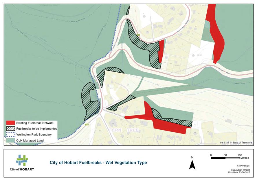
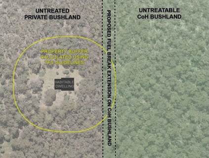
This is particularly the case for properties adjoining
the wet sclerophyll vegetation communities, much of which occurs around the
Fern Tree area.
This type of vegetation is generally unable to be treated by planned burning and as a consequence fuel breaks generally need to be wider so as to perform a more protective function.
(Refer diagram below)
4.7.12. All sites where fuel break improvement work is required have been assessed for significant flora, fauna and Aboriginal and historic heritage.
4.8. Piloting of New and Extension Fuel Breaks
4.8.1. The Council resolved, at its meeting of 21 November 2016, that the City construct a number of new and extended fuel breaks to enable assessment of the suitability of the new guidelines for Hobart.
4.8.2. Nine trial sites at Tolmans Hill, Mount Nelson and Lenah Valley, encompassing a total area of approximately 0.5ha were constructed in April-May 2017.
Photographs showing examples of the pilot site work are provided below:
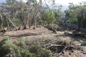
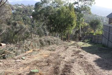
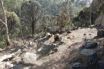
4.8.3. Construction was preceded by distribution of written information to adjacent landowners and other key stakeholders, including relevant Bushcare groups.
4.8.4. Only minor response was generated by the notification and subsequent commencement of works, several of which resulted in on-site meetings with immediate neighbours requiring further clarification of the works.
4.8.5. To date, community and stakeholder response to the trial sites works has been positive. The very few initial concerns received were addressed by on-site discussions and further clarification of the purpose and extent of works.
4.9. Adoption of Guidelines and Implementation of Fuel Break Network Improvement Works Program
4.9.1. The State Government’s new Fuel Break Guidelines (2016) and on-line calculator have been comprehensively ‘road-tested’ and have been assessed to be suitable for adoption and use by the City.
4.9.2. Application of the guidelines has confirmed that a modest expansion of the City’s existing fuel break network is required (as detailed in section 4.7.10 of this report)
4.9.3. The construction of several pilot sites exampled the new and extensions to existing fuel breaks confirmed low community concern.
4.9.4. It is proposed that the new fuel break guidelines and on-line calculator be adopted as the City’s standard for the design and construction of fuel breaks along the bushland-urban interface, except for new development sites where AS3959- 2009 Construction of buildings in bushfire prone areas is to apply.
4.9.5. If adopted, it is proposed to implement the required improvement works over the next several years, as funds permit, commencing in 2017/2018.
4.9.6. A program of works has been substantively developed and works contract and tender documentation is being finalised.
4.9.7. Environmental assessment of the sites has been completed and planning and environmental approvals requirements determined.
4.9.8. It is
expected that most if not all sites will be exempt from planning approval.
Design of each proposed new and extended fuel break
will incorporate the protection of any threatened species wherever possible and
hence eliminate or minimise the requirement for a threatened species permit in
accordance with the Threatened Species Protection Regulation 2006.
4.9.9. A
number of sites include threatened native vegetation communities listed under
Schedule 3A of the Nature Conservation Act 2002.
Again, the design of each of the fuel breaks will
minimise disturbance to these communities and the approval of the Forest
Practices Authority will be obtained in accordance with Cl.4(h) of the Forest
Practices Regulation 2007.
4.9.10. A total area of
approximately 10ha requires treatment across the City’s bushland
estate.
Works at each site will treat the vegetation to reduce
the overall fuel hazard rating to low, and include removal of most understory
and shrubs, selective lopping and removal of some canopy trees, and slashing
ground cover vegetation to 100mm height.
Where feasible, works will also include providing or
improving vehicle access for ongoing maintenance and future planned burning and
suppression operations.
4.9.11. A map of the proposed
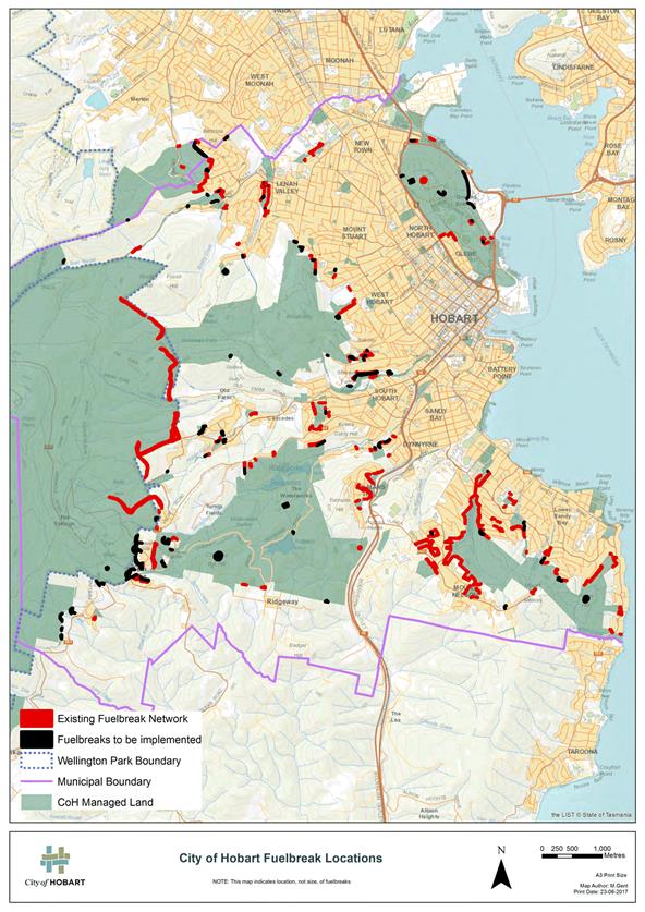
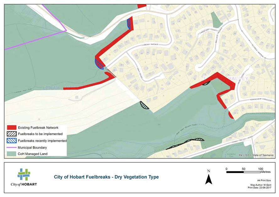
new and extensions to fuel breaks is attached as Attachment A.
Attachments B and C
show examples of some of the fuel break improvements at a larger scale and
illustrate the differing break widths that characterise the wet and dry
vegetation community types.
4.9.12. A community engagement process is proposed with owners of neighbouring properties containing significant areas of flammable vegetation, with the aim of negotiating cooperative treatment of the private property to complement the works on the adjoining City bushland estate.
4.10. Bushfire Hazard Reduction Program
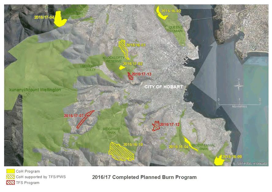
4.10.1. Ten planned hazard reduction burns encompassing a total area of approximately 180ha were conducted during 2016/2017 of which 128ha included City-owned or managed bushland.
4.10.2. An additional four planned burns (unable to be completed due to weather constraints) will be carried over to 2017/2018.
4.10.3. A summary table and map of completed 2016/2017 program is attached (refer Attachments D and E).
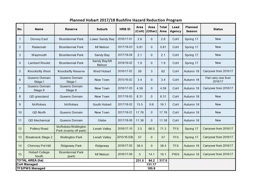
4.10.4. A program of fifteen
fuel reduction burns comprising all or part City bushland estate, is currently
planned for the spring and autumn seasons of 2017/2018.
Of the total planned area of approximately 317ha, 231
ha is City bushland estate with the balance being private and State owned
bushland.
4.10.5. A summary table and map of the proposed 2017/2018 program is attached as Attachments F and G.
4.11. Fire Trail Network
4.11.1. The 2016/2017 Fire Trail Upgrade Program resulted in 13 fire trails (comprising 4,030m) being upgraded to new specifications.
4.11.2. The Fire Trail Upgrade program will continue into 2017/2018.
4.12. Draft Inter Agency Agreement with the TFS
4.12.1. A draft Inter Agency Agreement has been provided by City officers to the TFS covering the planning, approval process and operational delivery of the City’s Hazard Reduction Burn Program. A meeting has been arranged with TFS representatives to progress the finalisation of the agreement.
5. Proposal and Implementation
5.1. Proposal and implementation for the three items subject of this report are addressed in the previous section.
6. Strategic Planning and Policy Considerations
6.1. The items relate to Capital City Strategic Plan 2015-2025 Strategic Objectives 3.2.1, 3.3.3 and 5.2.1.
Develop, implement and review fire management plans and associated programs for bushland reserves
Develop policies, strategies and standards to guide future management and development of the open space network
Manage bushfire risk through the implementation of the Hobart Fire Management Strategy
7. Financial Implications
7.1. Funding Source and Impact on Current Year Operating Result
7.1.1. Funding is included in the City’s Fire and Biodiversity program budget proposal for 2017/2018.
7.1.2. The 2016/2017 operational costs, in line with budgeted provisions, was $1.47M with capital expenditure an additional $449,000.
7.2. Impact on Future Years’ Financial Result
7.2.1. All items will require specific budget allocation in 2018/2019 and will be considered in the annual budget preparation process.
8. Legal, Risk and Legislative Considerations
8.1. The risk of bushfire is recognised as a significant risk in the City’s Strategic Risk Register and is resourced accordingly.
8.2. The City has specific management obligations under the Fire Services Act 1979, specifically:
· S.49: Fire hazards;
· S.56: Firebreak formation;
· S.63: Restrictions on fire lighting; and
· S.64: Duties of occupiers of land.
8.3. The City has fire management obligations under the Local Government Act 1993, specifically:
· S.200: The control of any ‘nuisance’ where nuisance is regarded as being ‘… causes or is likely to cause danger or harm to the health, safety or welfare of any person.’
8.4. The City has a Common Law responsibility to provide for the protection of residents arising from natural hazards within its reserves.
8.5. The intent of all items in this report has a common aim to reduce the City’s fire risk exposures as a land manager.
8.6. New and updated policy, plans and guidelines, aimed at fire risk mitigation, demonstrates the City’s commitment to improved bushfire risk management.
9. Environmental Considerations
9.1. Works and considerations associated with bushfire protection, where relevant, have already, or will be, preceded by appropriate environmental impact assessment and incorporate relevant safeguards and will not proceed without all required planning and environmental approvals.
10. Community and Stakeholder Engagement
10.1. All items include engagement with the community and stakeholders and as such the final plan, design and outcome is more likely to be accepted and supported by the community.
10.2. Adoption of new State Government guidelines for fuel breaks and program of works to rectify defects in City’s fuel break network will require preparation and implementation of a comprehensive community engagement strategy, specifically targeting and focusing on owners of properties immediately adjoining the City’s bushland estate where new and extensions to existing fuel breaks have been identified.
11. Delegation
11.1. The matter is delegated to the Council.
As signatory to this report, I certify that, pursuant to Section 55(1) of the Local Government Act 1993, I hold no interest, as referred to in Section 49 of the Local Government Act 1993, in matters contained in this report.
|
Bree Hunter (Acting) Team Leader Fire and Biodiversity |
Robert Mather (Acting) Director Parks and City Amenity |
Date: 4 August 2017
File Reference: F17/93823
Attachment a: Map
of Fuelbreak Locations ⇩ ![]()
Attachment
b: Map
of Fuelbreaks - Wet Vegetation Type ⇩ ![]()
Attachment
c: Map
of Fuelbreaks - Dry Vegetation Type ⇩ ![]()
Attachment
d: Completed
Program 2016/2017 ⇩ ![]()
Attachment
e: Map
of Completed Program 2016/2017 ⇩ ![]()
Attachment
f: Planned
Program 2017/2018 ⇩ ![]()
Attachment
g: Map
of Planned Program 2017/2018 ⇩ ![]()
|
Item No. 6.1 |
Agenda (Open Portion) Parks and Recreation Committee Meeting - 10/8/2017 |
Page 22 ATTACHMENT a |
|
Agenda (Open Portion) Parks and Recreation Committee Meeting - 10/8/2017 |
Page 23 ATTACHMENT b |
|
Agenda (Open Portion) Parks and Recreation Committee Meeting - 10/8/2017 |
Page 24 ATTACHMENT c |
|
Agenda (Open Portion) Parks and Recreation Committee Meeting - 10/8/2017 |
Page 25 ATTACHMENT d |
|
Agenda (Open Portion) Parks and Recreation Committee Meeting - 10/8/2017 |
Page 26 ATTACHMENT e |
|
Agenda (Open Portion) Parks and Recreation Committee Meeting - 10/8/2017 |
Page 27 ATTACHMENT f |
|
Agenda (Open Portion) Parks and Recreation Committee Meeting - 10/8/2017 |
Page 28 ATTACHMENT g |
|
Agenda (Open Portion) Parks and Recreation Committee Meeting |
Page 30 |
|
|
|
10/8/2017 |
|
A report indicating the status of current decisions is attached for the information of Aldermen.
REcommendation
That the information be received and noted.
Delegation: Committee
|
Item No. 7.1 |
Agenda (Open Portion) Parks and Recreation Committee Meeting - 10/8/2017 |
Page 31 ATTACHMENT a |
|
|
Agenda (Open Portion) Parks and Recreation Committee Meeting |
Page 46 |
|
|
10/8/2017 |
|
Section 29 of the Local Government (Meeting Procedures) Regulations 2015.
File Ref: 13-1-10
An Alderman may ask a question without notice of the Chairman, another Alderman, the General Manager or the General Manager’s representative, in line with the following procedures:
1. The Chairman will refuse to accept a question without notice if it does not relate to the Terms of Reference of the Council committee at which it is asked.
2. In putting a question without notice, an Alderman must not:
(i) offer an argument or opinion; or
(ii) draw any inferences or make any imputations – except so far as may be necessary to explain the question.
3. The Chairman must not permit any debate of a question without notice or its answer.
4. The Chairman, Aldermen, General Manager or General Manager’s representative who is asked a question may decline to answer the question, if in the opinion of the respondent it is considered inappropriate due to its being unclear, insulting or improper.
5. The Chairman may require a question to be put in writing.
6. Where a question without notice is asked and answered at a meeting, both the question and the response will be recorded in the minutes of that meeting.
7. Where a response is not able to be provided at the meeting, the question will be taken on notice and
(i) the minutes of the meeting at which the question is asked will record the question and the fact that it has been taken on notice.
(ii) a written response will be provided to all Aldermen, at the appropriate time.
(iii) upon the answer to the question being circulated to Aldermen, both the question and the answer will be listed on the agenda for the next available ordinary meeting of the committee at which it was asked, where it will be listed for noting purposes only.
|
|
Agenda (Open Portion) Parks and Recreation Committee Meeting |
Page 47 |
|
|
10/8/2017 |
|