City
of hobart
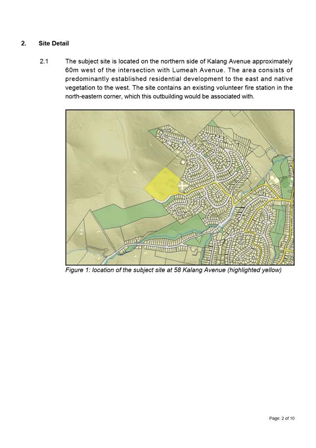
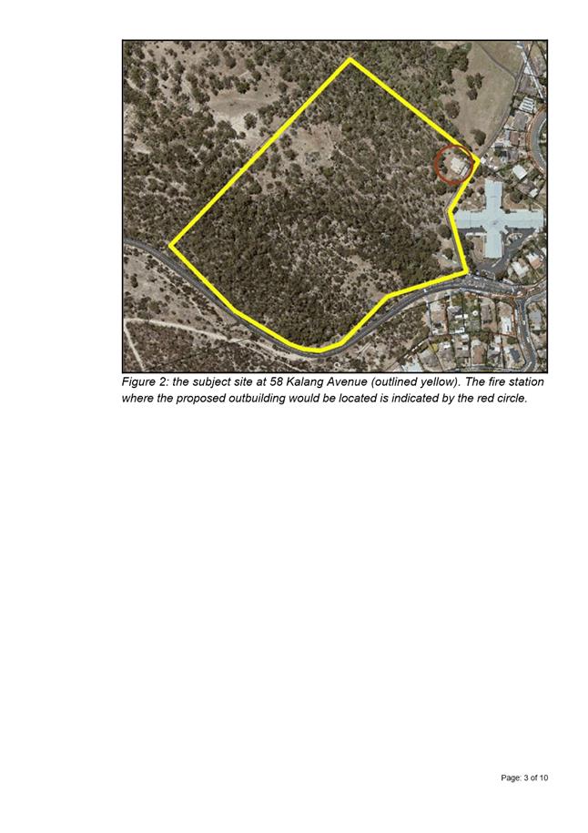
AGENDA
City Planning Committee Meeting
Open Portion
Monday, 14 August 2017
at 5.00 pm
Lady Osborne Room, Town Hall
City
of hobart
AGENDA
City Planning Committee Meeting
Open Portion
Monday, 14 August 2017
at 5.00 pm
Lady Osborne Room, Town Hall
THE MISSION
Our mission is to ensure good governance of our capital City.
THE VALUES
The Council is:
|
about people |
We value people – our community, our customers and colleagues. |
|
professional |
We take pride in our work. |
|
enterprising |
We look for ways to create value. |
|
responsive |
We’re accessible and focused on service. |
|
inclusive |
We respect diversity in people and ideas. |
|
making a difference |
We recognise that everything we do shapes Hobart’s future. |
|
|
Agenda (Open Portion) City Planning Committee Meeting |
Page 3 |
|
|
14/8/2017 |
|
Business listed on the agenda is to be conducted in the order in which it is set out, unless the committee by simple majority determines otherwise.
APOLOGIES AND LEAVE OF ABSENCE
1. Co-Option of a Committee Member in the event of a vacancy
3. Consideration of Supplementary Items
4. Indications of Pecuniary and Conflicts of Interest
6. Planning Authority Items - Consideration of Items With Deputations
7. Committee Acting as Planning Authority
7.1 Applications under the Hobart Interim Planning Scheme 2015
7.1.1 853 Sandy Bay Road, Sandy Bay - Multiple Dwellings
7.1.2 20 Fitzroy Crescent, Dynnyrne - Pergola
7.1.3 58 Kalang Avenue, Lenah Valley - Outbuilding
7.1.4 42 Argyle Street and 38 Argyle Street, Hobart - Partial Demolition, Alterations and Extension
7.1.5 100 Pinnacle Road, Mount Wellington - Works (Temporary Transmission Tower)
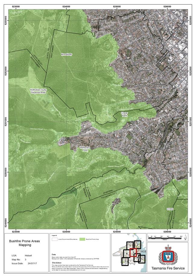
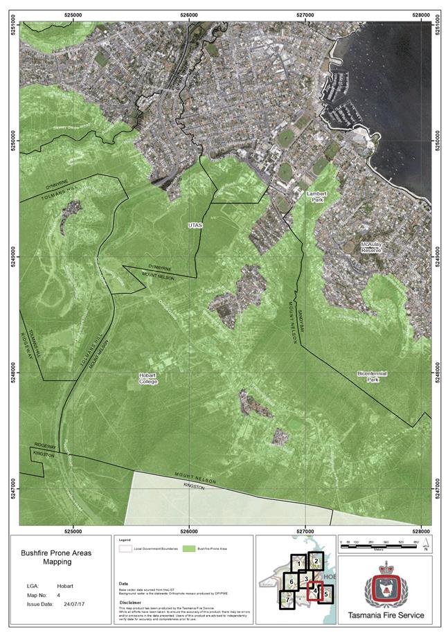
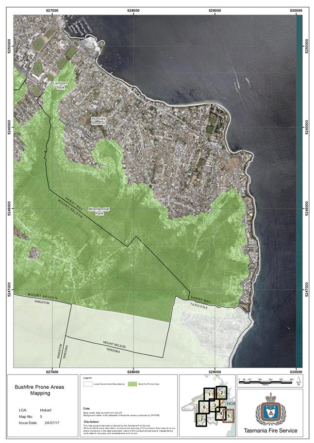
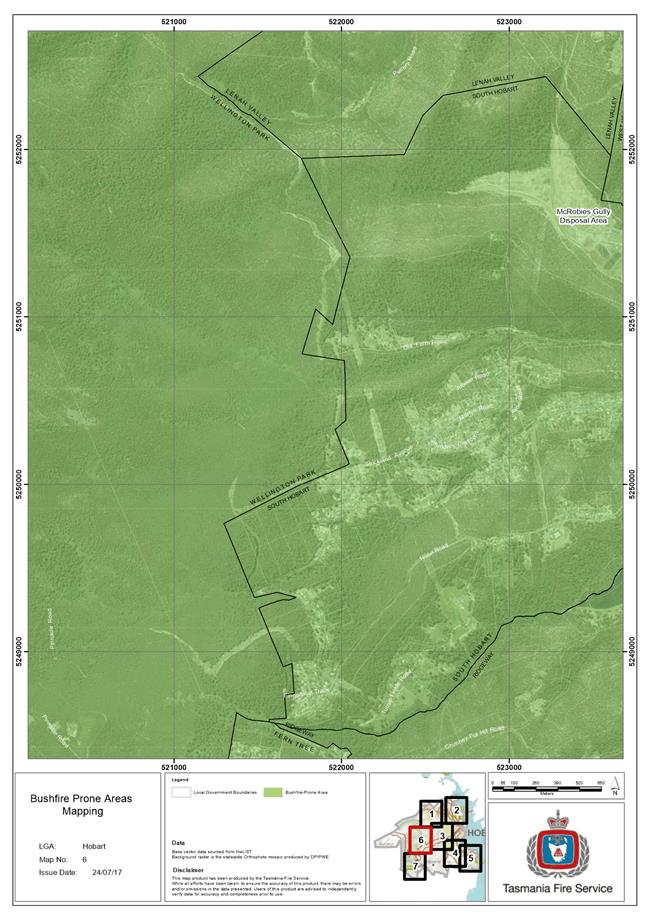
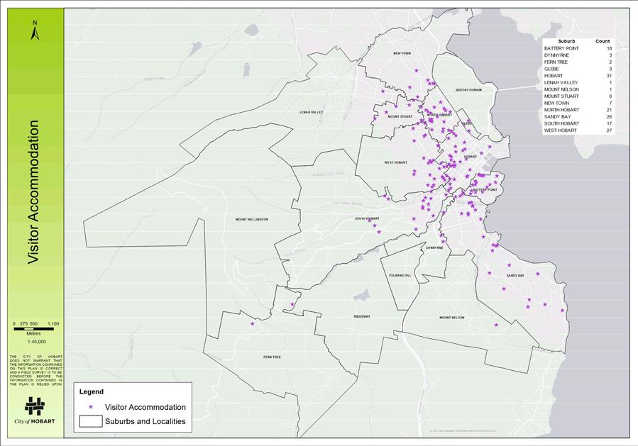
8.4 Visitor Accommodation Mapping
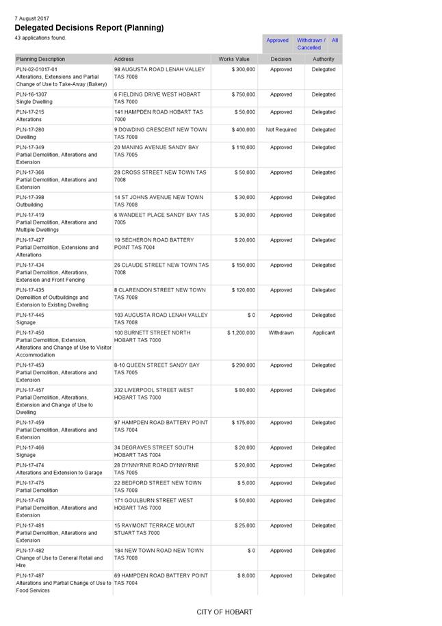
8.5 Delegated Decisions Report (Planning)
8.6 City Planning - Advertising List
9 Committee Action Status Report
9.1 Committee Actions - Status Report
10. Responses To Questions Without Notice
10.1 Interim Planning Scheme and Precinct 33
10.2 Construction Management Plans
10.3"Gattonside" 51 Sandy Bay Road, Battery Point
10.4 Interim Planning Scheme and the Original Intent of Precinct 33.
10.5 New Builds and Precinct 33
10.6 Planning Scheme Amendment and Precinct 33
10.7 Local Area Provisions and the Tasmanian Planning Scheme
10.8 Significant Trees Within Precinct 33
10.9 Development Potential Within Precinct 33
12. Closed Portion Of The Meeting
|
|
Agenda (Open Portion) City Planning Committee Meeting |
Page 5 |
|
|
14/8/2017 |
|
City Planning Committee Meeting (Open Portion) held Monday, 14 August 2017 at 5.00 pm in the Lady Osborne Room, Town Hall.
|
COMMITTEE MEMBERS Briscoe (Chairman) Ruzicka Burnet Denison
ALDERMEN Lord Mayor Hickey Deputy Lord Mayor Christie Zucco Sexton Cocker Thomas Reynolds Harvey |
Apologies: Nil.
Leave of Absence: Alderman J R Briscoe (Chairman). Alderman T M Denison.
|
|
The minutes of the Open Portion of the City Planning Committee meeting held on Monday, 31 July 2017, are submitted for confirming as an accurate record.
|
Ref: Part 2, Regulation 8(6) of the Local Government (Meeting Procedures) Regulations 2015.
|
That the Committee resolve to deal with any supplementary items not appearing on the agenda, as reported by the General Manager.
|
Ref: Part 2, Regulation 8(7) of the Local Government (Meeting Procedures) Regulations 2015.
Aldermen are requested to indicate where they may have any pecuniary or conflict of interest in respect to any matter appearing on the agenda, or any supplementary item to the agenda, which the committee has resolved to deal with.
Regulation 15 of the Local Government (Meeting Procedures) Regulations 2015.
A committee may close a part of a meeting to the public where a matter to be discussed falls within 15(2) of the above regulations.
In the event that the committee transfer an item to the closed portion, the reasons for doing so should be stated.
Are there any items which should be transferred from this agenda to the closed portion of the agenda, or from the closed to the open portion of the agenda?
In accordance with the requirements of Part 2 Regulation 8(3) of the Local Government (Meeting Procedures) Regulations 2015, the General Manager is to arrange the agenda so that the planning authority items are sequential.
In accordance with Part 2 Regulation 8(4) of the Local Government (Meeting Procedures) Regulations 2015, the Committee by simple majority may change the order of any of the items listed on the agenda, but in the case of planning items they must still be considered sequentially – in other words they still have to be dealt with as a single group on the agenda.
Where deputations are to be received in respect to planning items, past practice has been to move consideration of these items to the beginning of the meeting.
RECOMMENDATION
That in accordance with Regulation 8(4) of the Local Government (Meeting Procedures) Regulations 2015, the Committee resolve to deal with any items which have deputations by members of the public regarding any planning matter listed on the agenda, to be taken out of sequence in order to deal with deputations at the beginning of the meeting.
|
|
Agenda (Open Portion) City Planning Committee Meeting |
Page 7 |
|
|
14/8/2017 |
|
In accordance with the provisions of Part 2 Regulation 25 of the Local Government (Meeting Procedures) Regulations 2015, the intention of the Committee to act as a planning authority pursuant to the Land Use Planning and Approvals Act 1993 is to be noted.
In accordance with Regulation 25, the Committee will act as a planning authority in respect to those matters appearing under this heading on the agenda, inclusive of any supplementary items.
The Committee is reminded that in order to comply with Regulation 25(2), the General Manager is to ensure that the reasons for a decision by a Council or Council Committee acting as a planning authority are recorded in the minutes.
|
Agenda (Open Portion) City Planning Committee Meeting |
Page 8 |
|
|
|
14/8/2017 |
|
7.1 Applications under the Hobart Interim Planning Scheme 2015
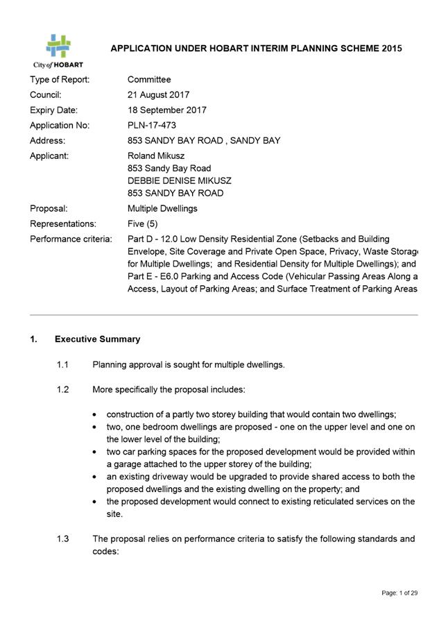
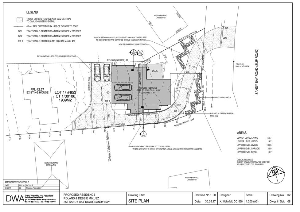
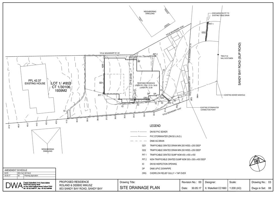
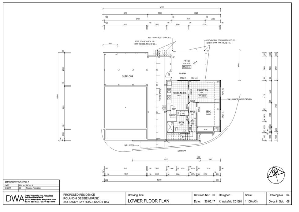
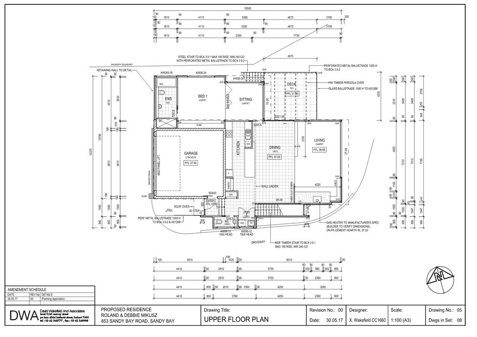
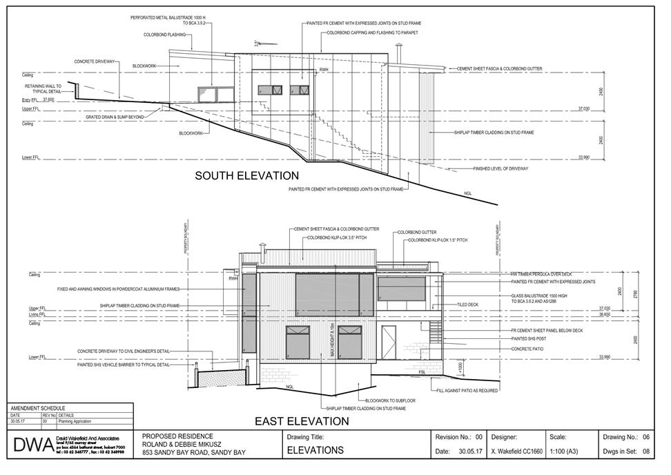
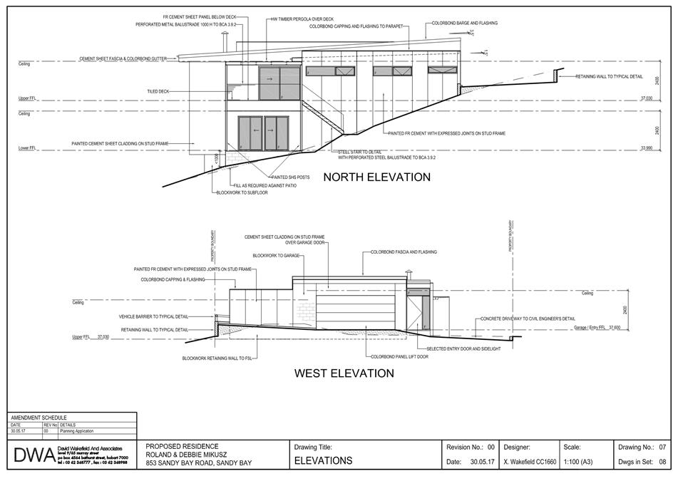
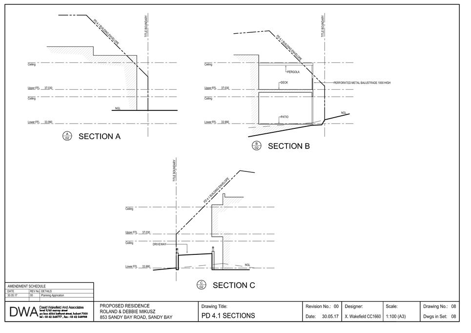
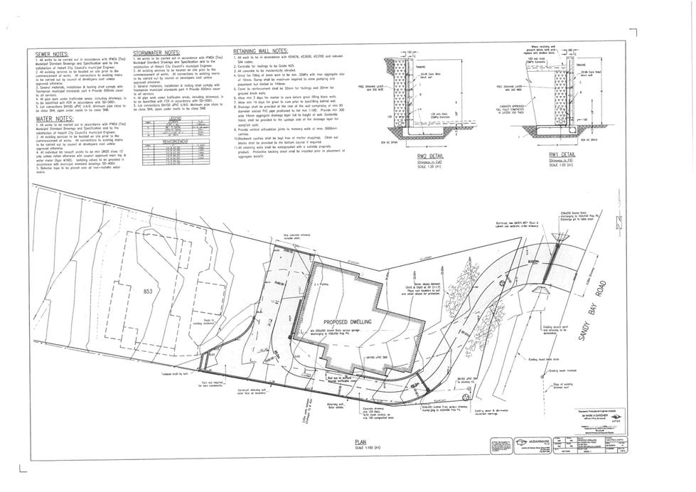
7.1.1 853 Sandy Bay Road, Sandy Bay - Multiple Dwellings
PLN-17-473 - FILE REF: F17/98056
Address: 853 Sandy Bay Road, Sandy Bay
Proposal: Multiple Dwellings
Expiry Date: 18 September 2017
Extension of Time: Not applicable
Author: Adam Smee
|
REcommendation Pursuant to the Hobart Interim Planning Scheme 2015, the Council approve the application for multiple dwellings at 853 Sandy Bay Road, Sandy Bay for the reasons outlined in the officer’s report and a permit containing the following conditions be issued:
GEN
The use and/or development must be substantially in accordance with the documents and drawings that comprise PLN17473 853 SANDY BAY ROAD SANDY BAY TAS 7005 Final Planning Documents except where modified below.
Reason for condition
To clarify the scope of the permit.
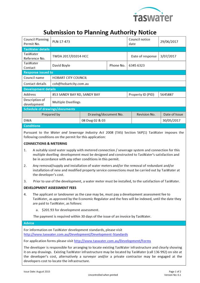
TW
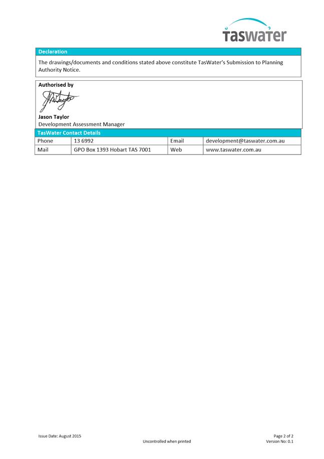
The use and/or development must comply with the requirements of TasWater as detailed in the form Submission to Planning Authority Notice, Reference No. TWDA 2017/01014HCC dated 3 July 2017 as attached to the permit.
Reason for condition
To clarify the scope of the permit.
PLN 2
Screening with no more than 25% uniform transparency and a minimum height of 1.5m above finished floor level, must be installed and maintained along the northern edge of the patio on the lower level of the development and the deck attached to its upper level prior to first occupation of the building.
Design drawings must be submitted and approved prior to the issuing of any building permit under the Building Act 2016. The design drawings must show the location, height, material and transparency of the screening to satisfy the above requirement.
All work required by this condition must be undertaken in accordance with the approved design drawings.
Reason for condition
To provide reasonable opportunity for privacy for dwellings.
PLN 3
Storage for waste and recycling bins must be provided for the development. The storage must be:
1. capable of storing the number of bins required for the site; and
2. screened from the frontage and dwellings; and
3. if the storage area is a communal storage area, separated from dwellings on the site to minimise impacts caused by odours and noise.
Plans must be submitted and approved prior to the issuing of any building permit under the Building Act 2016 demonstrating compliance with the above requirements.
All work required by this condition must be undertaken in accordance with the approved plans.
Reason for condition
To ensure that waste and recycling bins do not impact on the amenity of the locality and to ensure compliance with the waste storage standards in the Hobart Interim Planning Scheme 2015.
PLN s1
The approved dwellings must share any water, sewerage, gas, electricity and telecommunications connections and meters. Separate connections and meters must not be provided for the approved dwellings without separate and further planning approval.
Advice: This condition does not relate to the current existing dwelling on the site.
Reason for condition
To ensure that the use of the development is consistent with clause 12.4.9 Residential density for multiple dwellings of the Hobart Interim Planning Scheme 2015.
ENG sw4
The development (including the full length of the driveway) must be drained to Council stormwater infrastructure, prior to occupation of the development.
Where a new stormwater service connection is required, the new stormwater connection must be constructed at the owner’s expense and all existing connections abandoned and sealed by Council at the owner’s expense, prior to occupation of the development.
Where a new stormwater service connection is required, an application for a new stormwater service connection must be submitted and approved by the Director City Infrastructure prior to obtaining any plumbing Certificate of Likely Compliance under the Building Act 2016.
Advice:
· Once the detailed engineered drawings have been approved the Council will issue a condition endorsement (see general advice on how to obtain condition endorsement).
· It is advised that documentation for condition endorsement is lodged well before a Building Permit is required, as failure to address design requirements until Building Application stage may result in unexpected delays.
· Please note that once the condition endorsement has been issued the owner/developer will need to contact Council’s City Infrastructure Unit to initiate an application for a new stormwater service connection.
Reason for condition
To ensure the site is drained adequately.
ENG sw6
All stormwater from the proposed development (including roofed areas, ag drains, retaining wall ag drains, and impervious surfaces such as driveways or similar) must be discharged to the Council’s stormwater infrastructure via the property stormwater connection.
All costs associated with works required by this condition are to be met by the owner.
All work required by this condition must be undertaken in accordance with the approved design drawings.
Advice:
· Once the design drawings and calculations have been approved Council will issue a condition endorsement (see general advice on how to obtain condition endorsement).
· Please note that the entire driveway located within the property boundary of 853 is required to be drained via the property stormwater connection to Council Stormwater Infrastructure. This may require a grated trench across the driveway just inside the front boundary. If gradients prevent this from draining to the existing stormwater connection, a new stormwater connection may be required.
Reason for condition
To ensure that stormwater from the site will be discharged to a suitable Council approved outlet.
ENG 2
Vehicle safety barriers where required by Australian Standard AS/NZS2890.1:2004 and compliant with AS/NZS1170.1:2002 must be installed prior to occupation of the development.
If barriers are not required by AS/NZS2890.1:2004; a report, prepared by a suitably qualified person, demonstrating that barriers are not required must be submitted and approved by Council prior to the issuing of any Certificate of Likely Compliance under the Building Act 2016.
If vehicle safety barriers are required, a certified vehicle crash barrier design (including site plan with proposed location(s) of installation), prepared by a suitably qualified Engineer, to satisfy the above requirements, must be submitted and approved by Council prior to the issuing of any Certificate of Likely Compliance under the Building Act 2016. All works required by this condition must be undertaken in accordance with certified design.
Prior to the issuing of any Occupancy or Completion Certificate under the Building Act 2016, barriers must be inspected by a qualified engineer and certification submitted to Council, confirming that the installed barriers comply with the above requirement.
Advice:
· Where vehicle safety barriers are not required due to a drop of less than 600mm, the designers should make this clear on the drawings to help avoid unnecessary delays in building approval.
· Where wheelstops (i.e kerb 90 to 110mm high) are not required due to a drop of less than 150mm, the designers should make this clear on the drawings to help avoid unnecessary delays in building approval.
· Council consider that barriers and wheelstops are required for parking modules, circulation roadways, ramps and domestic driveways.
· Designers are advised to consult the National Construction Code 2016 to determine if pedestrian handrails or safety barriers compliant with the NCC2016 are also required: click here for more information.
· Council do not consider a slope greater than 1 in 4 to constitute a lower level as described in AS/NZS 2890.1:2004 Section 2.4.5.3
· Once the design drawing has been approved Council will issue a condition endorsement (see general advice on how to obtain condition endorsement).
Reason for condition
To ensure that the safety of users of the driveway/parking and compliance with the standard.
ENG 11
Prior to the commencement of work, the detailed design of the proposed crossover to the Sandy Bay Road Access Road highway reservation must be submitted and approved by Council.
Advice
· Once the design drawing has been approved Council will issue a condition endorsement (see general advice on how to obtain condition endorsement).
· It is advised that documentation for condition endorsement is lodged well before a Building Permit is required, as failure to address design requirements until Building Application stage may result in unexpected delays.
· The crossover will require
a design that incorporates components of Urban TSDR09v1
– Urban Roads Driveways and TSD R14v1 Type KC vehicular crossing,
and Rural – TSDR04v1 – Rural Roads Typical Driveway
Profile and TSD R03v1 Rural Roads Typical Property Access. It is advised
to contact Council City Infrastructure Roads Officer on 6238 2836 to ensure a
satisfactory design is achieved. · Please note that stormwater pipe class for the culvert will need to comply with the notes on TSD R03v1 Rural Roads Typical Property Access
· Local Government Association Tasmania (LGAT) Standard Drawings can be viewed electronically via the LGAT website.
Reason for condition
In the interests of vehicle user safety and the amenity of the development.
ENG 3
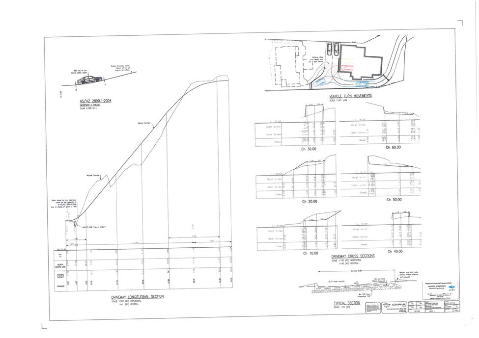
The driveway manoeuvring area must ensure that the inside wheel path gradient does not exceed 10%.
A detailed driveway design must be submitted and approved by Council, prior to the issuing of any Certificate of Likely Compliance under the Building Act 2016. The detailed driveway design must be prepared and certified by a suitably qualified engineer as in accordance with the Australian Standard AS/NZS2890.1:2004 (including the requirement for vehicular safety barriers), or, that the design provides for a safe and efficient access.
All work required by this condition must be undertaken in accordance with the approved design drawings.
Advice:
Once the design drawings have been approved Council will issue a condition endorsement (see general advice on how to obtain condition endorsement).
Reason for condition
To ensure that the access and parking layout for the development is to accepted standards.
ENG 14
The driveway access must:
1. include a passing bay at approximately 20m chainage that is 5.5m wide, 6m long with a taper to the width of the driveway at each end;
2. ensure that the inside wheel path gradient does not exceed 25%; and
3. include vehicular barriers where the drop is greater than 600mm and a wheelstop where the drop is greater than 150mm.
A detailed driveway access design must be submitted to and approved by Council, prior to the issuing of any Certificate of Likely Compliance for the development under the Building Act 2016. The detailed driveway access design must be prepared and certified by a suitably qualified engineer as in accordance with the Australian Standard AS/NZS2890.1:2004 (including the requirement for pedestrian and vehicular sightlines, and vehicular safety barriers), or, that the design provides for a safe and efficient access.
All work required by this condition must be undertaken in accordance with the approved design drawings
Advice:
Once the design drawing has been approved Council will issue a condition endorsement (see general advice on how to obtain condition endorsement).
Reason for condition
To ensure that the access and parking layout for the development is to accepted standards.
ENG 1
The cost of repair of any damage to the Council infrastructure resulting from the implementation of this permit, must be met by the owners within 30 days of the completion of the development or as otherwise determined by the Council.
A photographic record of the Council infrastructure adjacent to the subject site must be provided to the Council prior to any commencement of works.
A photographic record of the Council’s infrastructure (e.g. existing property service connection points, roads, buildings, stormwater, footpaths, driveway crossovers and nature strips, including if any, pre existing damage) will be relied upon to establish the extent of damage caused to the Council’s infrastructure during construction. In the event that the owner/developer fails to provide to the Council a photographic record of the Council’s infrastructure, then any damage to the Council infrastructure found on completion of works will be deemed to be the responsibility of the owner.
Reason for condition
To ensure that any of the Council infrastructure and/or siterelated service connections affected by the proposal will be altered and/or reinstated at the owner’s full cost.
ADVICE
The following advice is provided to you to assist in the implementation of the planning permit that has been issued subject to the conditions above. The advice is not exhaustive and you must inform yourself of any other legislation, bylaws, regulations, codes or standards that will apply to your development under which you may need to obtain an approval. Visit the Council's website for further information.
Prior to any commencement of work on the site or commencement of use the following additional permits/approval may be required from the Hobart City Council.
CONDITION ENDORSEMENT
If a condition endorsement is required by a planning condition above, you will need to submit the relevant documentation to satisfy the condition via the Condition Endorsement Submission on Council's online services eplanning
Where building approval is also required, it is recommended that documentation for condition endorsement be submitted well before submitting documentation for building approval. Failure to address condition endorsement requirements prior to submitting for building approval may result in unexpected delays.
Once approved, the Council will respond to you via email that the condition has been endorsed (satisfied). Detailed instructions can be found here.
BUILDING PERMIT
Building permit in accordance with the Building Act 2016. Click here for more information.
PLUMBING PERMIT
Plumbing permit in accordance with the Building Act 2016, Building Regulations 2016 and the National Construction Code. Click here for more information.
NEW SERVICE CONNECTION
New service connection (please contact the Hobart City Council's City Infrastructure Division to initiate the application process).
STORM WATER
Please note that in addition to a building and/or plumbing permit, development must be in accordance with the Hobart City Council’s Hydraulic Services By law. Click here for more information.
WORK WITHIN THE HIGHWAY RESERVATION
Please note development must be in accordance with the Hobart City Council’s Highways By law. Click here for more information.
ACCESS
Designed in accordance with LGAT IPWEA – Tasmanian standard drawings. Click here for more information.
CROSS OVER CONSTRUCTION
The construction of the crossover can be undertaken by the Council or by a private contractor, subject to Council approval of the design. Click here for more information.
STORM WATER / ROADS / ACCESS
Services to be designed and constructed in accordance with the (IPWEA) LGAT standard drawings. Click here for more information.
TREES ON COUNCIL OWNED LAND
Separate approval from Council as land manager is needed to remove trees on Council owned land.
|
Attachment a: PLN-17-473
- 853 SANDY BAY ROAD SANDY BAY TAS 7005 - Planning Committee or Delegated
Report ⇩ ![]()
Attachment
b: PLN-17-473
853 SANDY BAY ROAD SANDY BAY TAS 7005 - CPC Agenda Documents ⇩ ![]()
|
Item No. 7.1.1 |
Agenda (Open Portion) City Planning Committee Meeting - 14/8/2017 |
Page 19 ATTACHMENT a |
|
Agenda (Open Portion) City Planning Committee Meeting - 14/8/2017 |
Page 48 ATTACHMENT b |
|
Item No. 7.1.1 |
Agenda (Open Portion) City Planning Committee Meeting - 14/8/2017 |
Page 52 ATTACHMENT b |
|
Item No. 7.1.2 |
Agenda (Open Portion) City Planning Committee Meeting |
Page 63 |
|
|
14/8/2017 |
|
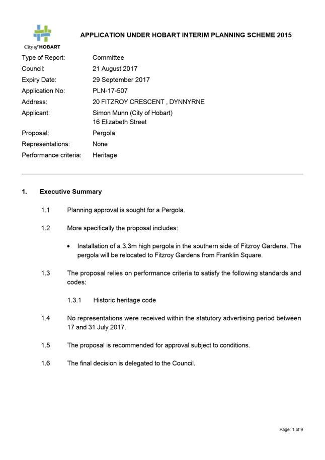
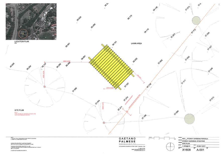
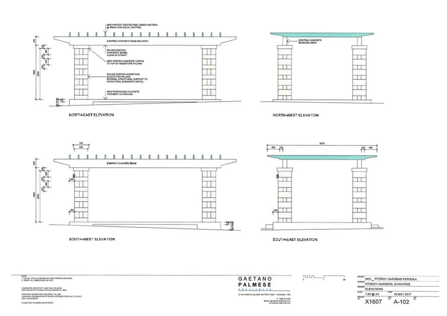
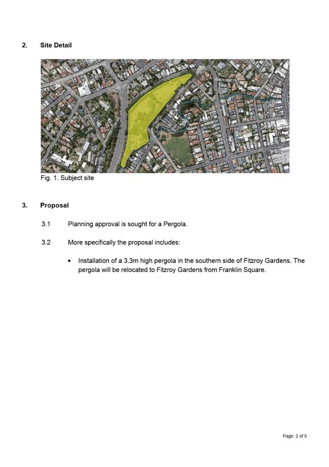
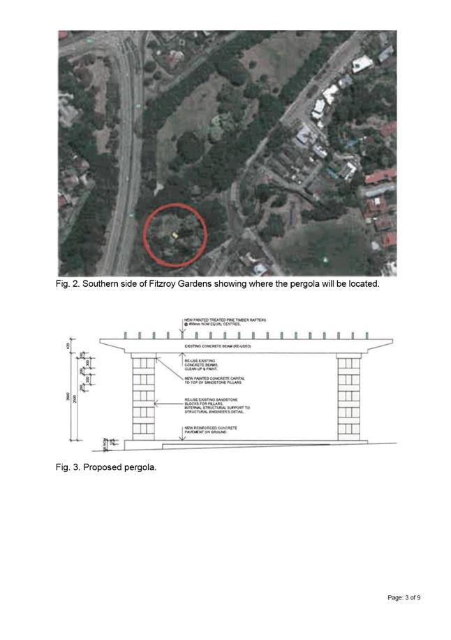
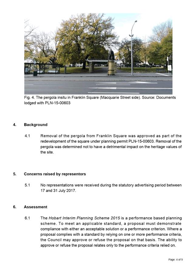
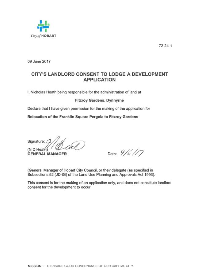
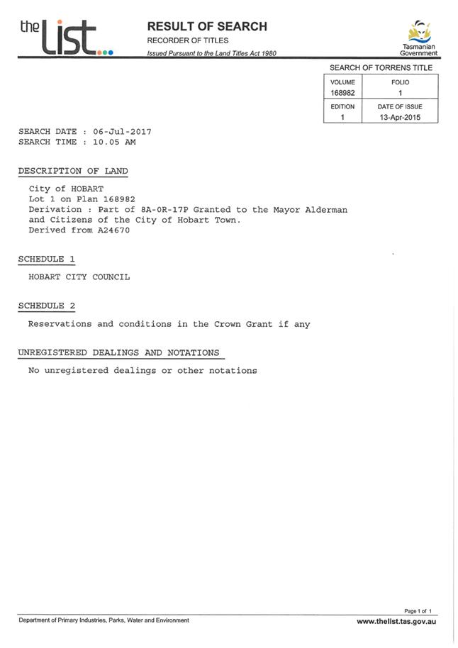
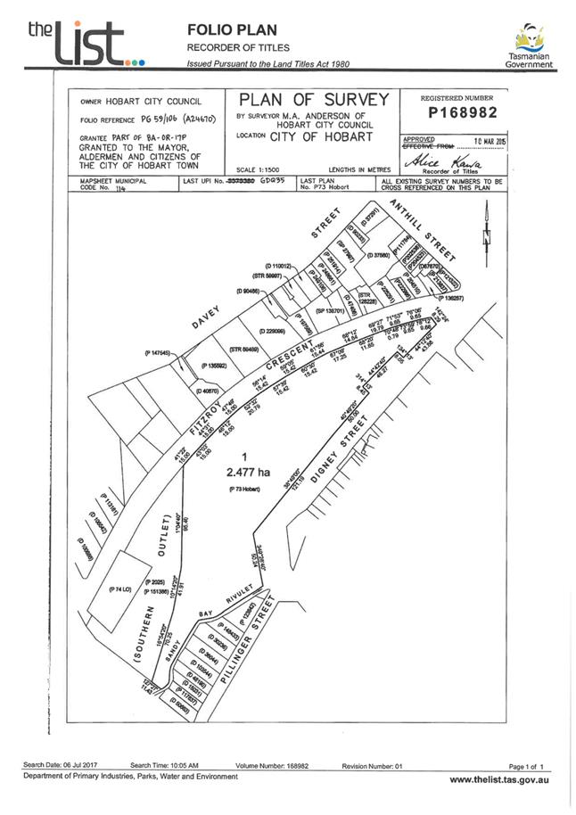
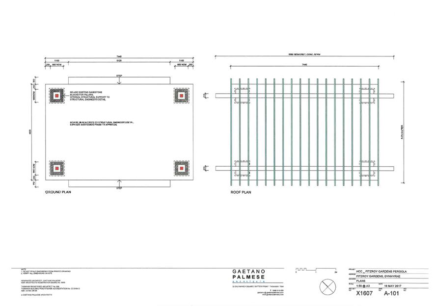
7.1.2 20 Fitzroy Crescent, Dynnyrne - Pergola
PLN-17-507 - FILE REF: F17/96275
Address: 20 Fitzroy Crescent, Dynnyrne
Proposal: Pergola
Expiry Date: 29 September 2017
Extension of Time: Not applicable
Author: Elizabeth Wilson
|
REcommendation Pursuant to the Hobart Interim Planning Scheme 2015, the Council approve the application for a pergola at 20 Fitzroy Crescent, DYNNYRNE for the reasons outlined in the officer’s report and a permit containing the following conditions be issued:
GEN
The use and/or development must be substantially in accordance with the documents and drawings that comprise PLN17507 20 FITZROY CRESCENT DYNNYRNE TAS 7005 Final Planning Documents except where modified below.
Reason for condition
To clarify the scope of the permit.
ADVICE
The following advice is provided to you to assist in the implementation of the planning permit that has been issued subject to the conditions above. The advice is not exhaustive and you must inform yourself of any other legislation, bylaws, regulations, codes or standards that will apply to your development under which you may need to obtain an approval. Visit the Council's website for further information.
Prior to any commencement of work on the site or commencement of use the following additional permits/approval may be required from the Hobart City Council.
BUILDING PERMIT
Building permit in accordance with the Building Act 2016. Click here for more information.
DIAL BEFORE YOU DIG
Click here for dial before you dig information. .
|
Attachment a: PLN-17-507
- 20 FITZROY CRESCENT DYNNYRNE TAS 7005 - Planning Committee or Delegated
Report ⇩ ![]()
Attachment
b: PLN-17-507
- 20 FITZROY CRESCENT DYNNYRNE TAS 7005 - CPC Agenda Documents ⇩ ![]()
|
Item No. 7.1.2 |
Agenda (Open Portion) City Planning Committee Meeting - 14/8/2017 |
Page 65 ATTACHMENT a |
|
Agenda (Open Portion) City Planning Committee Meeting - 14/8/2017 |
Page 74 ATTACHMENT b |
|
Item No. 7.1.2 |
Agenda (Open Portion) City Planning Committee Meeting - 14/8/2017 |
Page 78 ATTACHMENT b |
|
Item No. 7.1.3 |
Agenda (Open Portion) City Planning Committee Meeting |
Page 82 |
|
|
14/8/2017 |
|
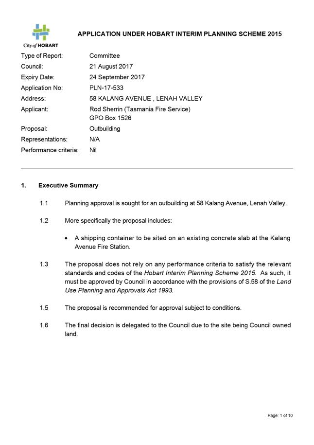
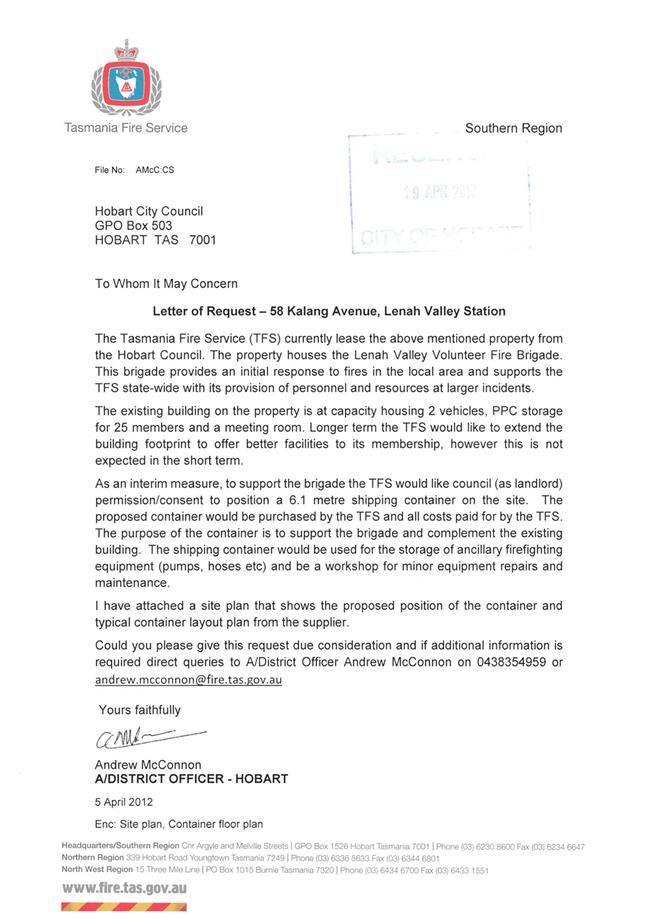
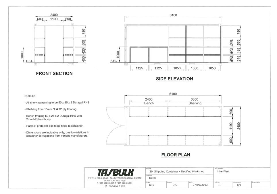
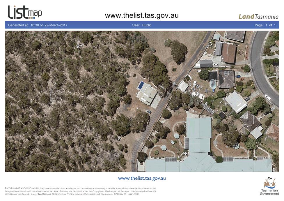
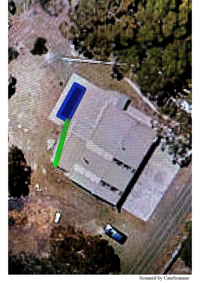
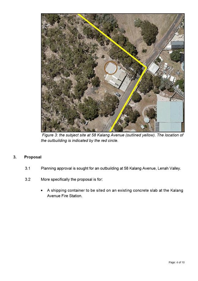
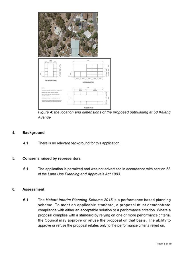
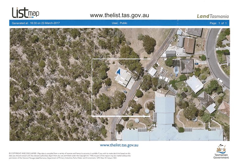
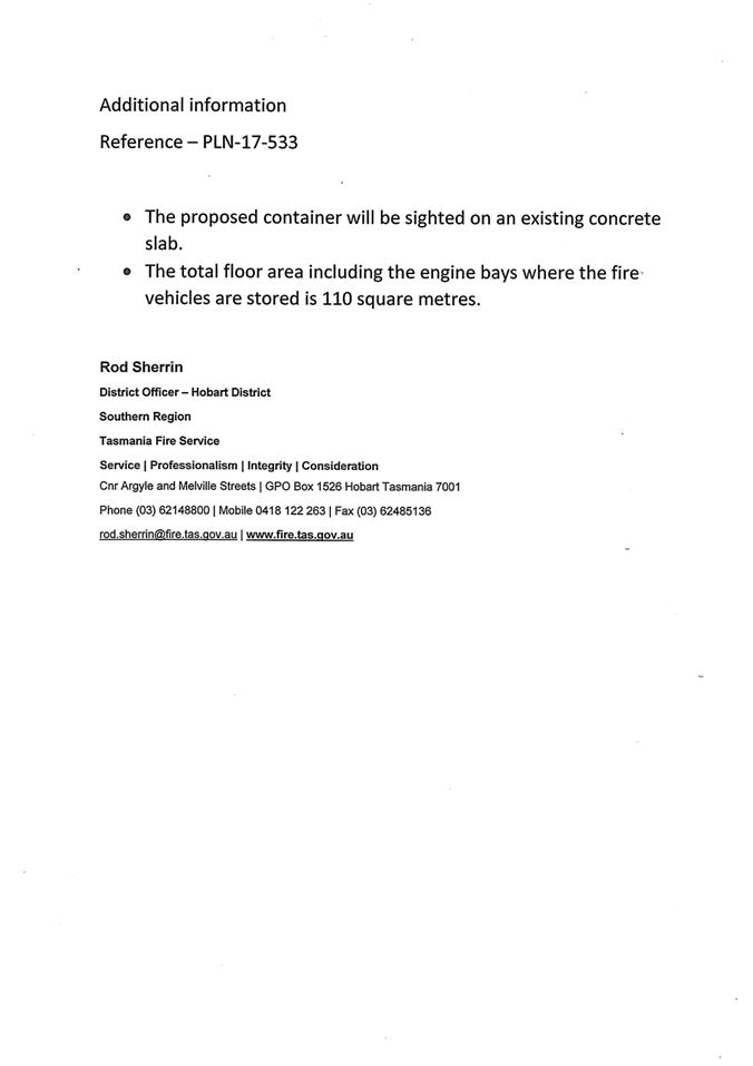
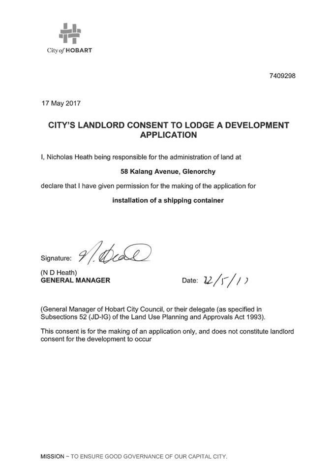
7.1.3 58 Kalang Avenue, Lenah Valley - Outbuilding
PLN-17-533 - FILE REF: F17/96397
Address: 58 Kalang Avenue, Lenah Valley
Proposal: Outbuilding
Expiry Date: 24 September 2017
Extension of Time: Not applicable
Author: Michaela Nolan
|
REcommendation Pursuant to the Hobart Interim Planning Scheme 2015, the Council approve the application for an outbuilding at 58 Kalang Avenue, Lenah Valley for the reasons outlined in the officer’s report and a permit containing the following conditions be issued:
GEN
The use and/or development must be substantially in accordance with the documents and drawings that comprise PLN17533 58 KALANG AVENUE LENAH VALLEY TAS 7008 Final Planning Documents except where modified below.
Reason for condition
To clarify the scope of the permit.
ENG 1
The cost of repair of any damage to the Council infrastructure resulting from the implementation of this permit, must be met by the owners within 30 days of the completion of the development or as otherwise determined by the Council.
A photographic record of the Council infrastructure adjacent to the subject site must be provided to the Council prior to any commencement of works.
A photographic record of the Council’s infrastructure (e.g. existing property service connection points, roads, buildings, stormwater, footpaths, driveway crossovers and nature strips, including if any, pre existing damage) will be relied upon to establish the extent of damage caused to the Council’s infrastructure during construction. In the event that the owner/developer fails to provide to the Council a photographic record of the Council’s infrastructure, then any damage to the Council infrastructure found on completion of works will be deemed to be the responsibility of the owner.
Reason for condition
To ensure that any of the Council infrastructure and/or siterelated service connections affected by the proposal will be altered and/or reinstated at the owner’s full cost.
ENV 1
Sediment and erosion control measures sufficient to prevent sediment from leaving the site must be installed prior to any disturbance of the site. Sediment controls must be maintained until all areas of disturbance have been stabilized or revegetated.
Advice: For further guidance in preparing a Soil and Water Management Plan – in accordance with Fact Sheet 3 Derwent Estuary Program click here.
Reason for condition
To avoid the sedimentation of roads, drains, natural watercourses, Council land that could be caused by erosion and runoff from the development, and to comply with relevant State legislation.
ADVICE
The following advice is provided to you to assist in the implementation of the planning permit that has been issued subject to the conditions above. The advice is not exhaustive and you must inform yourself of any other legislation, bylaws, regulations, codes or standards that will apply to your development under which you may need to obtain an approval. Visit the Council's website for further information.
Prior to any commencement of work on the site or commencement of use the following additional permits/approval may be required from the Hobart City Council.
BUILDING PERMIT
Building permit in accordance with the Building Act 2016. Click here for more information. PLUMBING PERMIT
Plumbing permit in accordance with the Building Act 2016, Building Regulations 2016 and the National Construction Code. Click here for more information.
|
Attachment a: PLN-17-533
- 58 KALANG AVENUE LENAH VALLEY TAS 7008 - Planning Committee or Delegated
Report ⇩ ![]()
Attachment
b: PLN-17-533
- 58 KALANG AVENUE LENAH VALLEY TAS 7008 - CPC Agenda Documents ⇩ ![]()
|
Item No. 7.1.3 |
Agenda (Open Portion) City Planning Committee Meeting - 14/8/2017 |
Page 85 ATTACHMENT a |

|
Agenda (Open Portion) City Planning Committee Meeting - 14/8/2017 |
Page 95 ATTACHMENT b |
|
Item No. 7.1.3 |
Agenda (Open Portion) City Planning Committee Meeting - 14/8/2017 |
Page 96 ATTACHMENT b |
|
Item No. 7.1.3 |
Agenda (Open Portion) City Planning Committee Meeting - 14/8/2017 |
Page 99 ATTACHMENT b |
|
Item No. 7.1.3 |
Agenda (Open Portion) City Planning Committee Meeting - 14/8/2017 |
Page 101 ATTACHMENT b |
|
Item No. 7.1.4 |
Agenda (Open Portion) City Planning Committee Meeting |
Page 107 |
|
|
14/8/2017 |
|
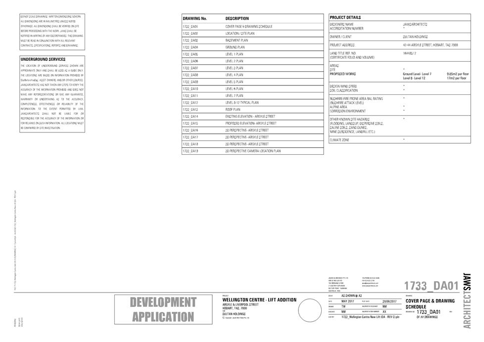
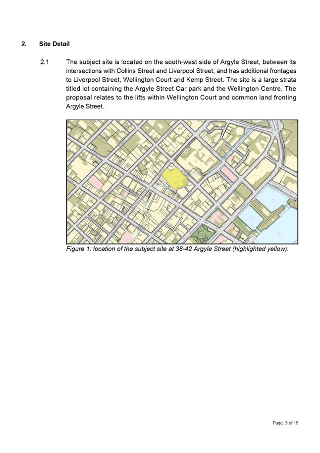
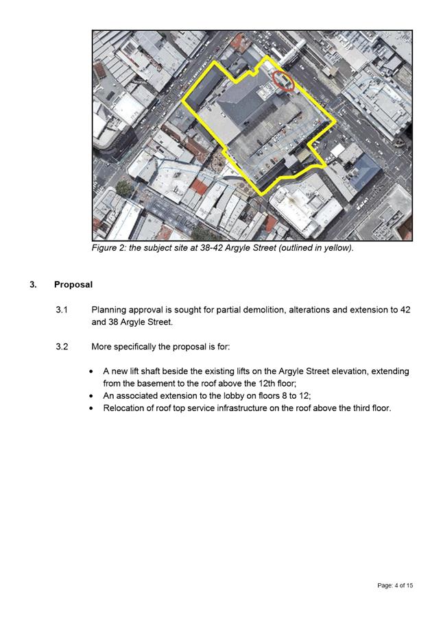
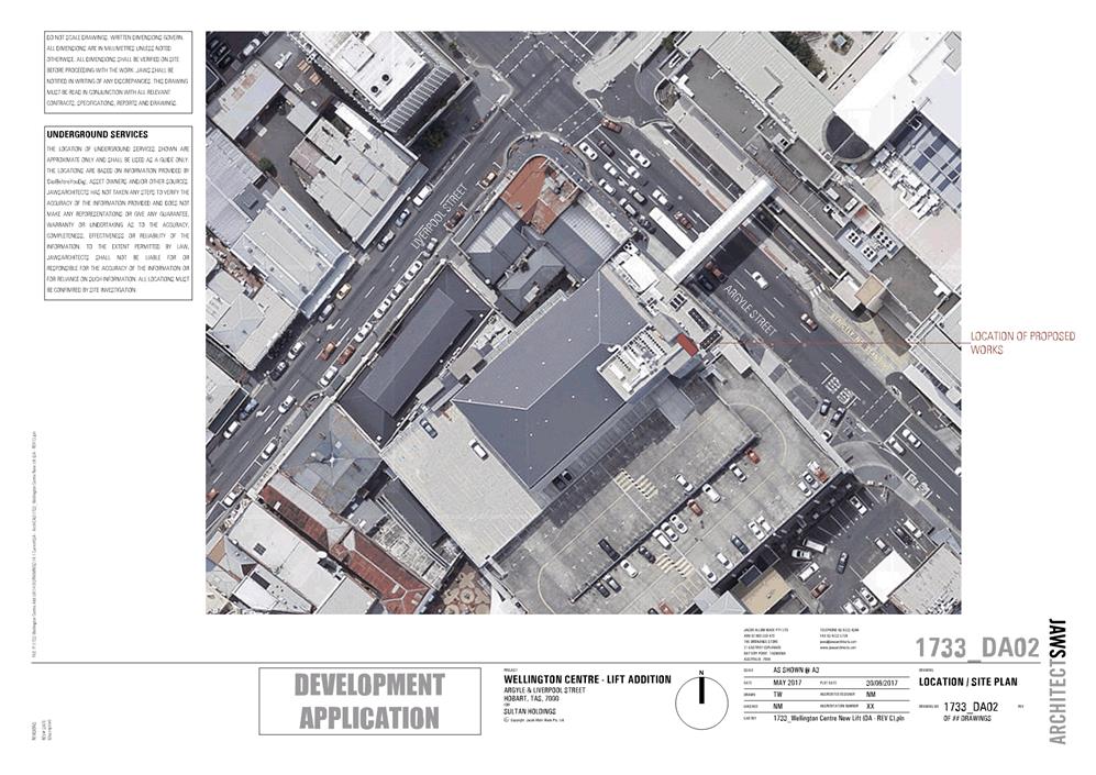
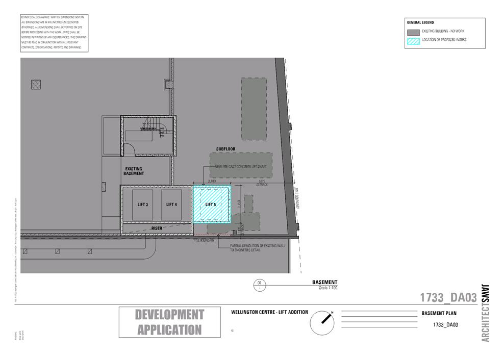
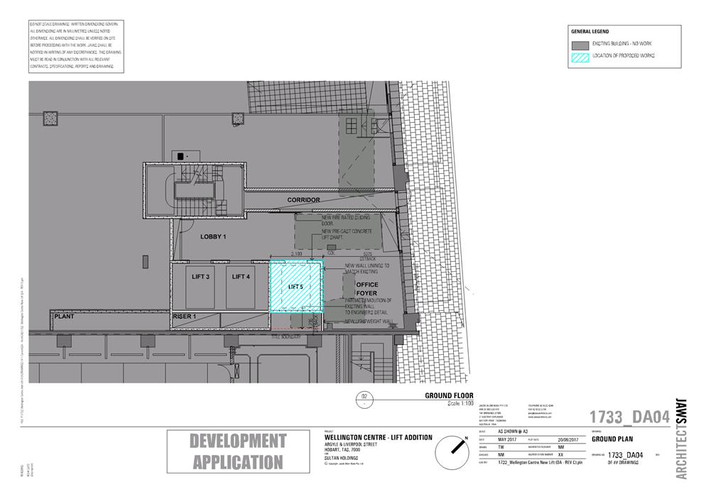
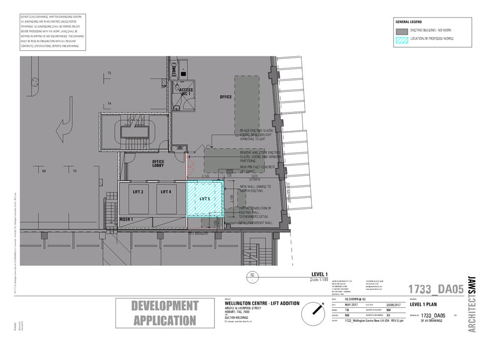
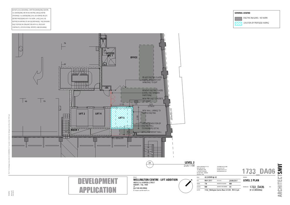
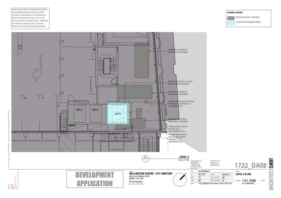
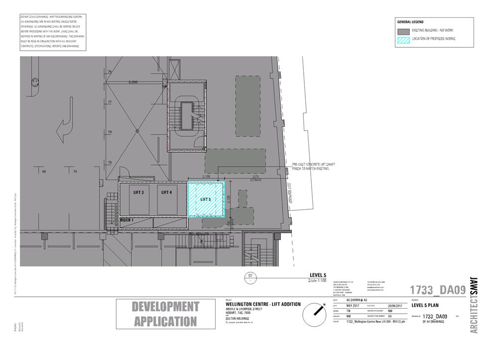
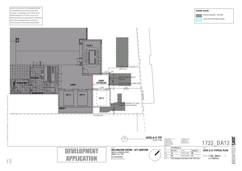
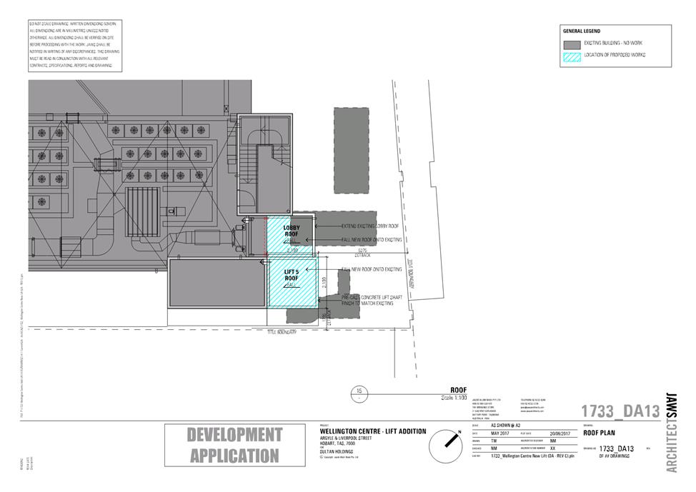
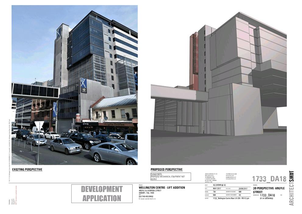
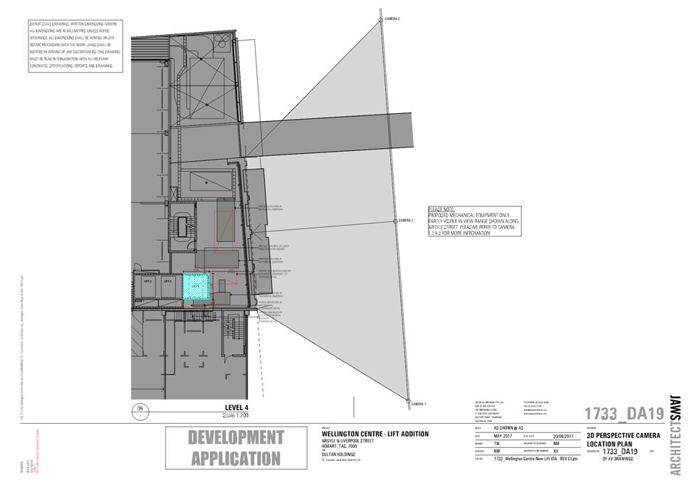
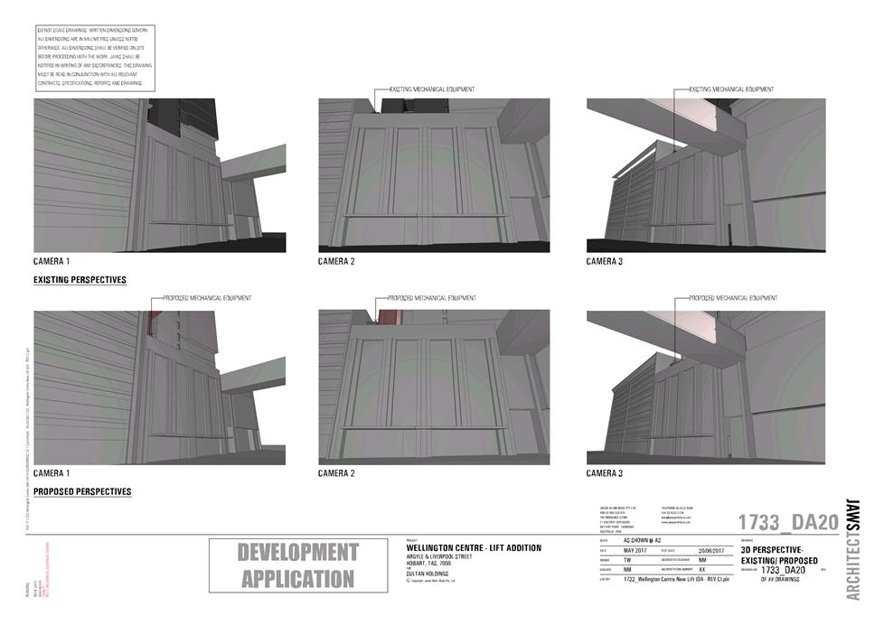
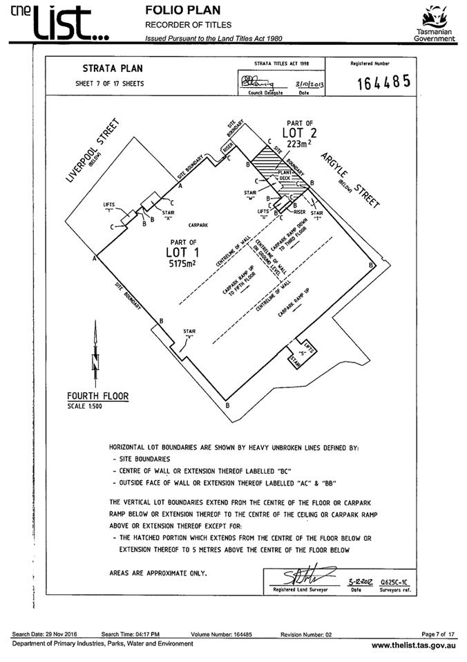
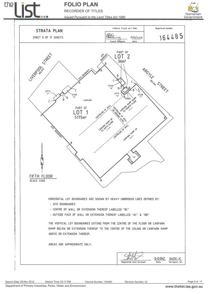
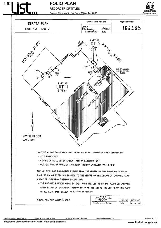
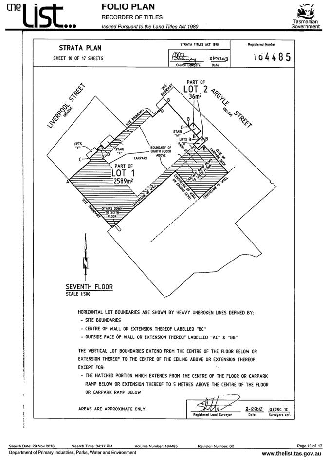
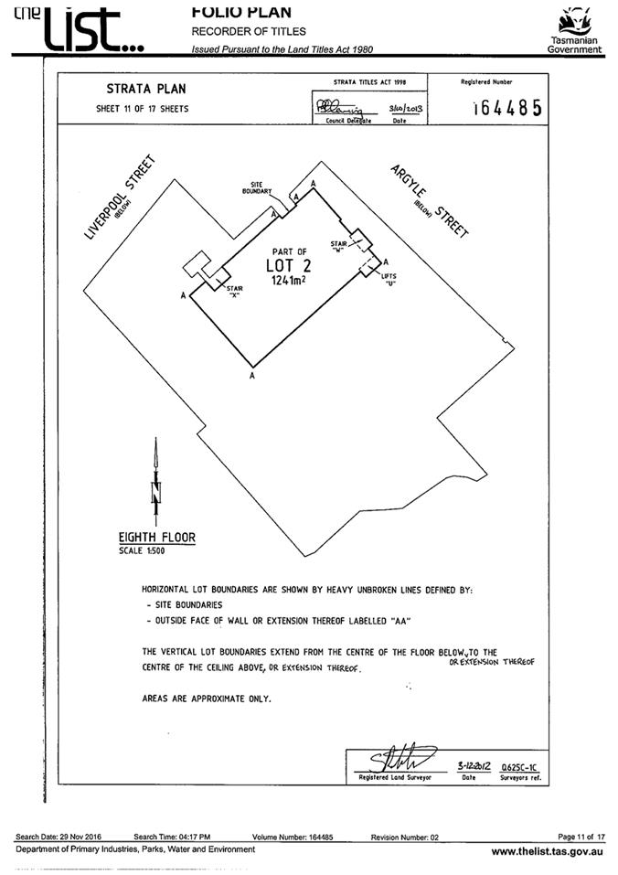
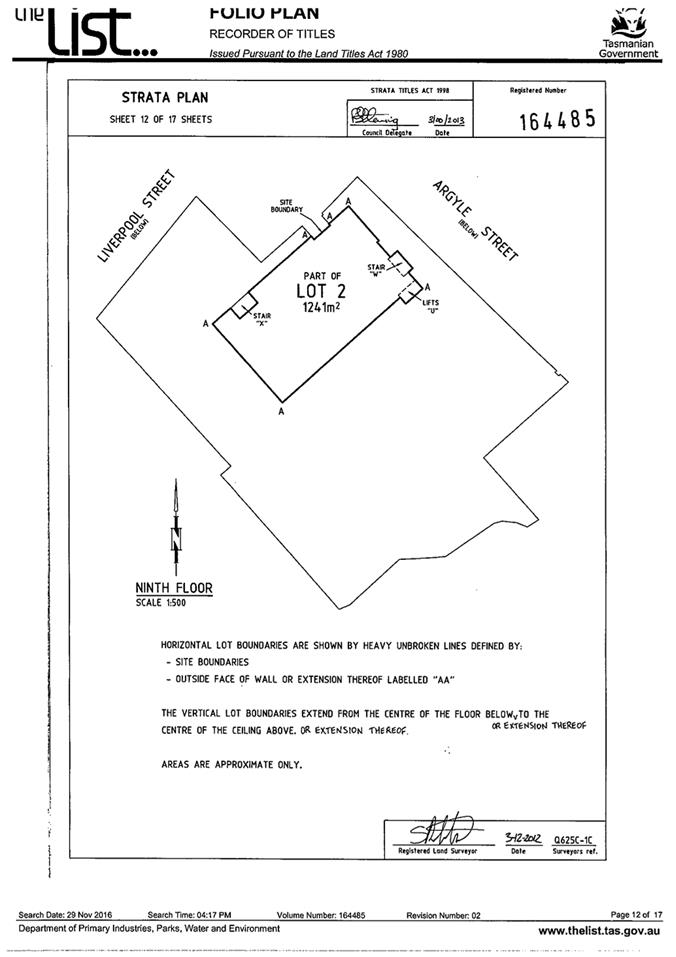
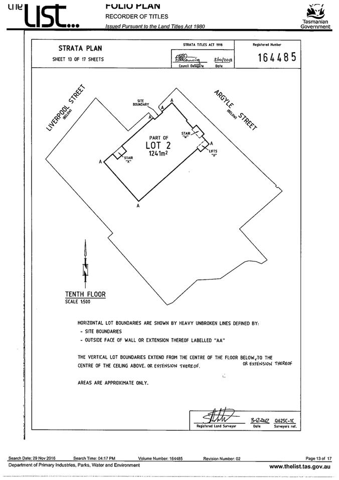
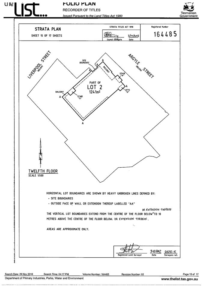
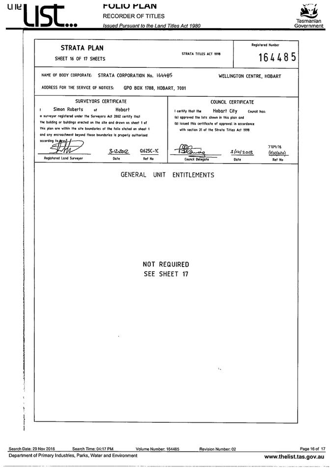
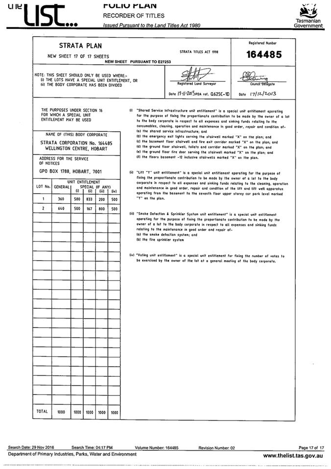
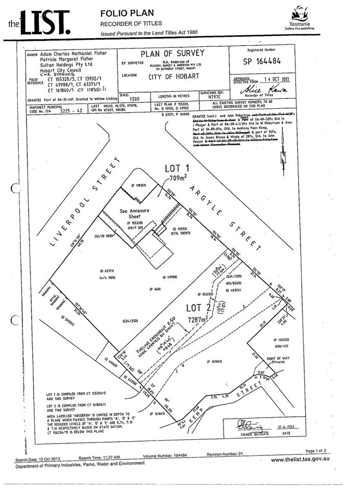
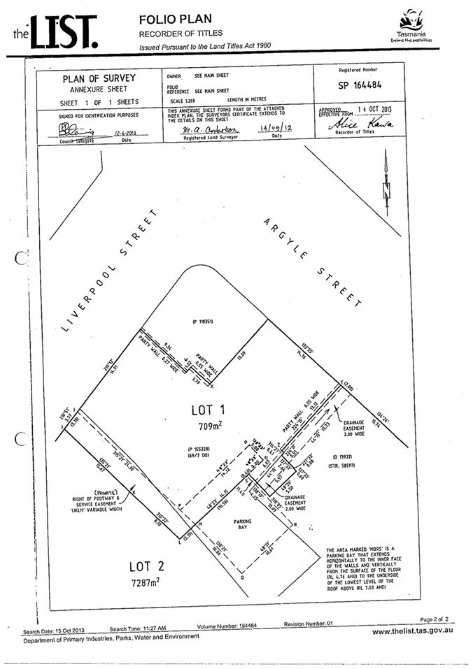
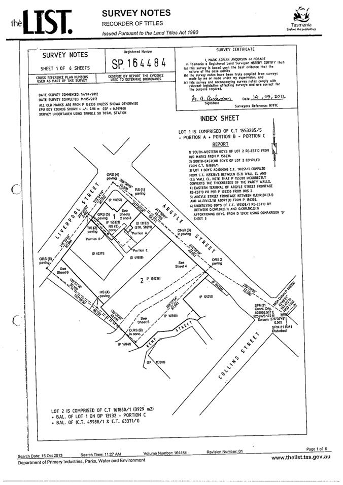
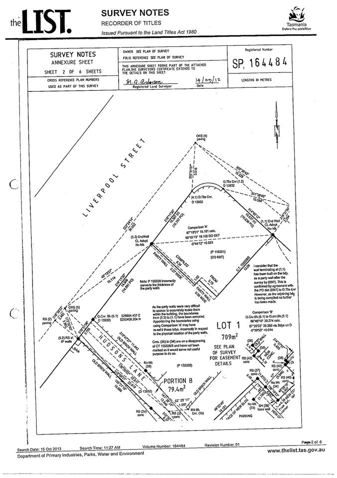
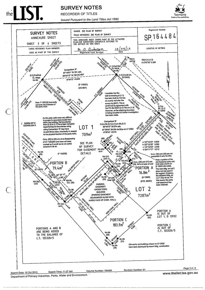
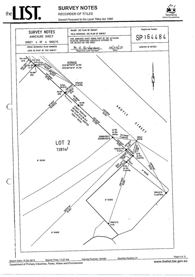
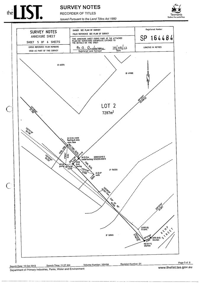
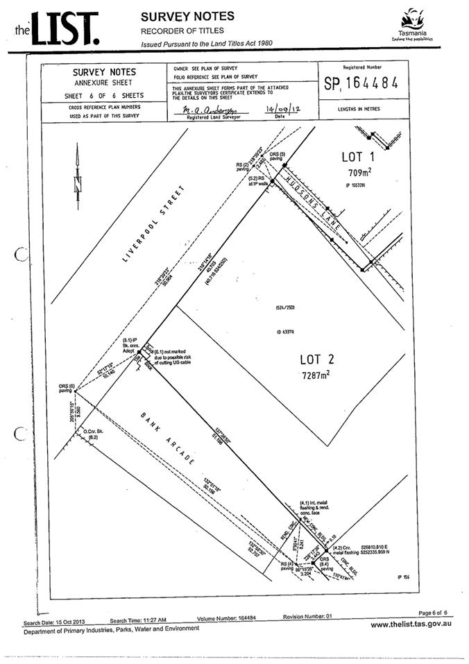
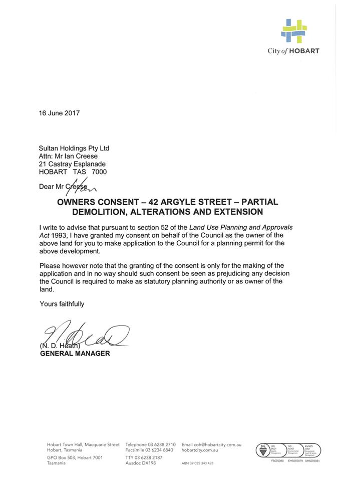
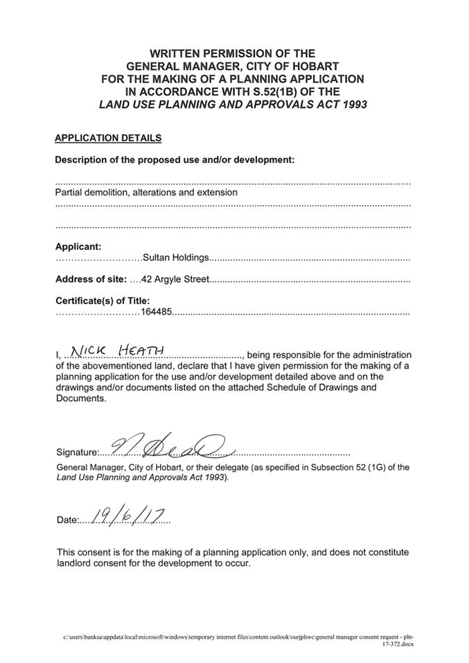
7.1.4 42 Argyle Street and 38 Argyle Street, Hobart - Partial Demolition, Alterations and Extension
pln-17-372 - FILE REF: F17/96329
Address: 42 Argyle Street and 38 Argyle Street, Hobart
Proposal: Partial Demolition, Alterations and Extension
Expiry Date: 24 August 2017
Extension of Time: Not applicable
Author: Michaela Nolan
|
REcommendation Pursuant to the Hobart Interim Planning Scheme 2015, the Council approve the application for partial demolition, alterations and extension to 42 and 38 Argyle Street, Hobart for the reasons outlined in the officer’s report and a permit containing the following conditions be issued:
GEN
The use and/or development must be substantially in accordance with the documents and drawings that comprise PLN17372 42 ARGYLE STREET and 38 ARGYLE STREET HOBART TAS 7000 Final Planning Documents except where modified below.
Reason for condition
To clarify the scope of the permit.
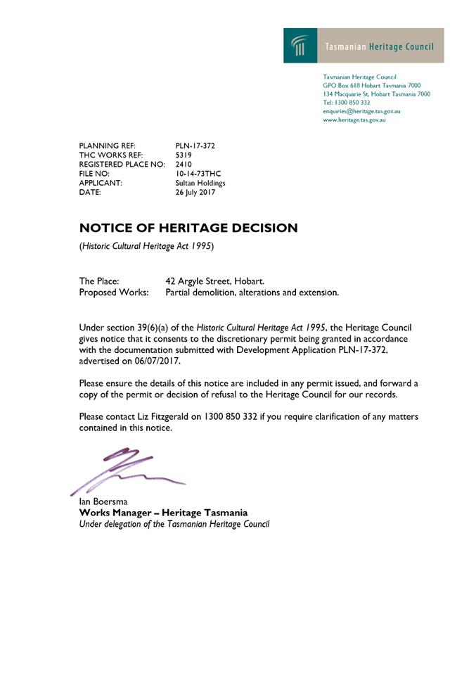
THC
The use and/or development must comply with the requirements of the Tasmanian Heritage Council as detailed in the Notice of Heritage Decision, THC Application No. 5319 dated 26 July 2017, as attached to the permit.
Reason for condition
To clarify the scope of the permit.
ENG 1
The cost of repair of any damage to the Council infrastructure resulting from the implementation of this permit, must be met by the owners within 30 days of the completion of the development or as otherwise determined by the Council.
A photographic record of the Council infrastructure adjacent to the subject site must be provided to the Council prior to any commencement of works.
A photographic record of the Council’s infrastructure (e.g. existing property service connection points, roads, buildings, stormwater, footpaths, driveway crossovers and nature strips, including if any, pre existing damage) will be relied upon to establish the extent of damage caused to the Council’s infrastructure during construction. In the event that the owner/developer fails to provide to the Council a photographic record of the Council’s infrastructure, then any damage to the Council infrastructure found on completion of works will be deemed to be the responsibility of the owner.
Reason for condition
To ensure that any of the Council infrastructure and/or siterelated service connections affected by the proposal will be altered and/or reinstated at the owner’s full cost.
ENV 1
Sediment and erosion control measures sufficient to prevent sediment from leaving the site must be installed prior to any disturbance of the site. Sediment controls must be maintained until all areas of disturbance have been stabilized or revegetated.
Advice: For further guidance in preparing a Soil and Water Management Plan – in accordance with Fact sheet 3 Derwent Estuary Program click here.
Reason for condition
To avoid the sedimentation of roads, drains, natural watercourses, Council land that could be caused by erosion and runoff from the development, and to comply with relevant State legislation.
ADVICE
The following advice is provided to you to assist in the implementation of the planning permit that has been issued subject to the conditions above. The advice is not exhaustive and you must inform yourself of any other legislation, bylaws, regulations, codes or standards that will apply to your development under which you may need to obtain an approval. Visit the Council's website for further information. Prior to any commencement of work on the site or commencement of use the following additional permits/approval may be required from the Hobart City Council.
BUILDING PERMIT
Building permit in accordance with the Building Act 2016. Click here for more information.
PLUMBING PERMIT
Plumbing permit in accordance with the Building Act 2016, Building Regulations 2016 and the National Construction Code. Click here for more information.
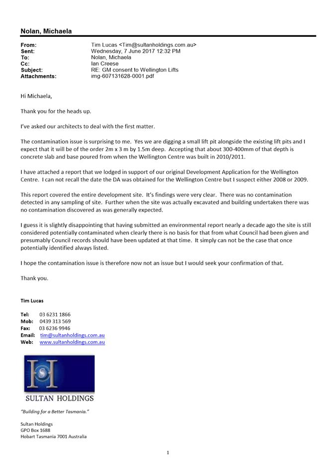
WORK PLACE HEALTH AND SAFETY
Please note that potentially contaminating activities may have historically occurred on this property. If contaminated soil and/or groundwater is present on the site, its exposure and disturbance may present risks to human health. It is therefore recommended that appropriate workplace health and safety measures be employed during any excavation to minimise human exposure to potentially contaminated soil, water, dust and vapours. Workplace Standards Tasmania or a suitably experienced and qualified WH&S practitioner should be consulted for advice if required. .
|
Attachment a: PLN-17-372
- 42 ARGYLE STREET HOBART TAS 7000 - Planning Committee or Delegated Report ⇩ ![]()
Attachment
b: PLN-17-372
42 ARGYLE STREET & 38 ARGYLE STREET HOBART TAS 7000 - CPC Agenda Documents ⇩ ![]()
|
Item No. 7.1.4 |
Agenda (Open Portion) City Planning Committee Meeting - 14/8/2017 |
Page 110 ATTACHMENT a |
|
Agenda (Open Portion) City Planning Committee Meeting - 14/8/2017 |
Page 125 ATTACHMENT b |


|
Item No. 7.1.4 |
Agenda (Open Portion) City Planning Committee Meeting - 14/8/2017 |
Page 146 ATTACHMENT b |

|
Item No. 7.1.5 |
Agenda (Open Portion) City Planning Committee Meeting |
Page 188 |
|
|
14/8/2017 |
|
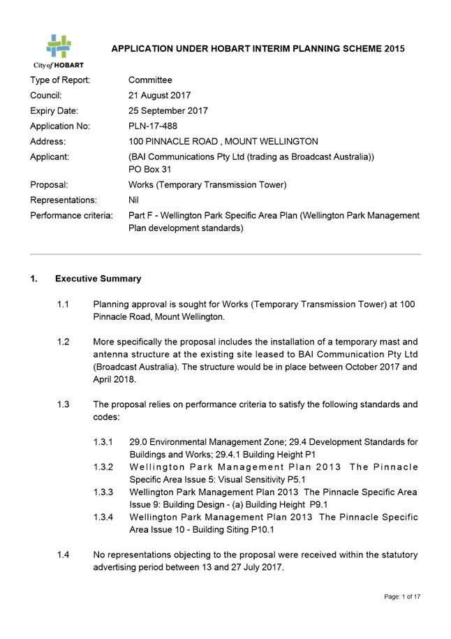
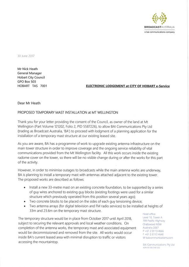
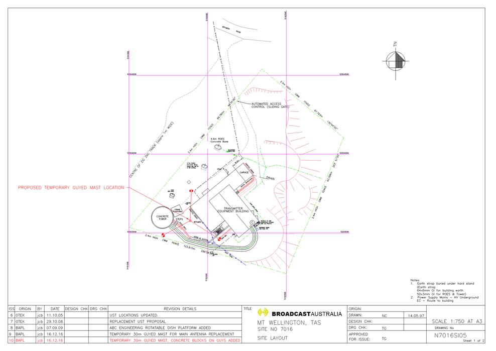
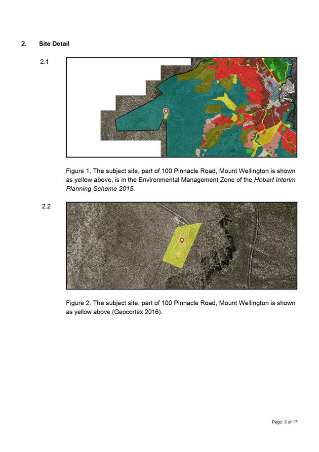
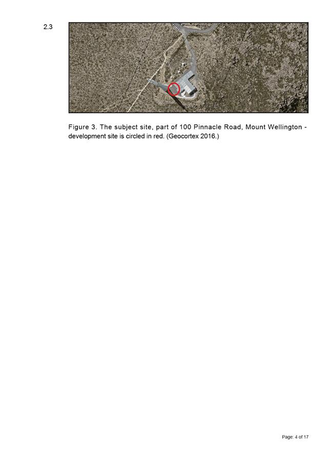
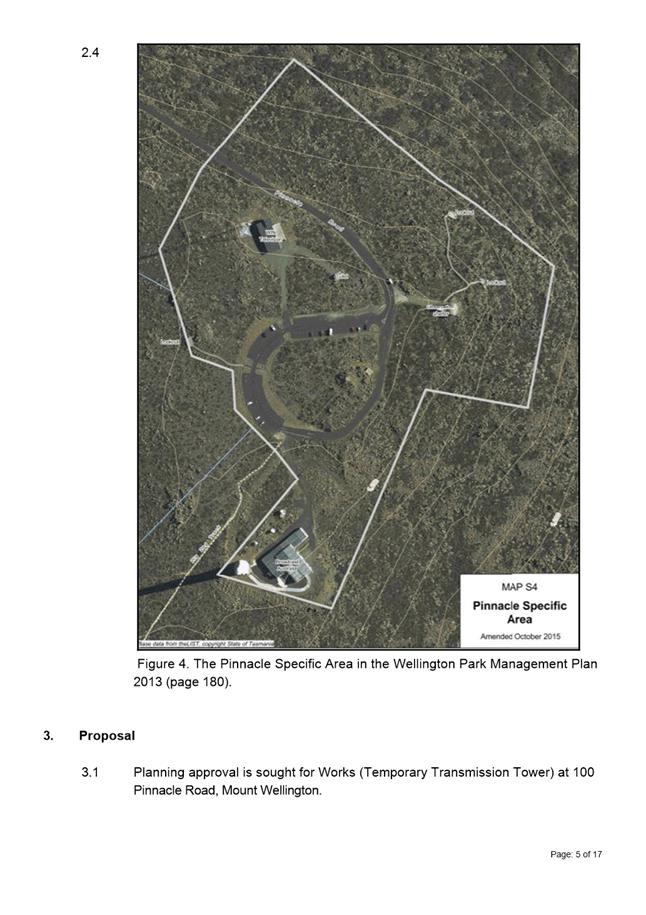
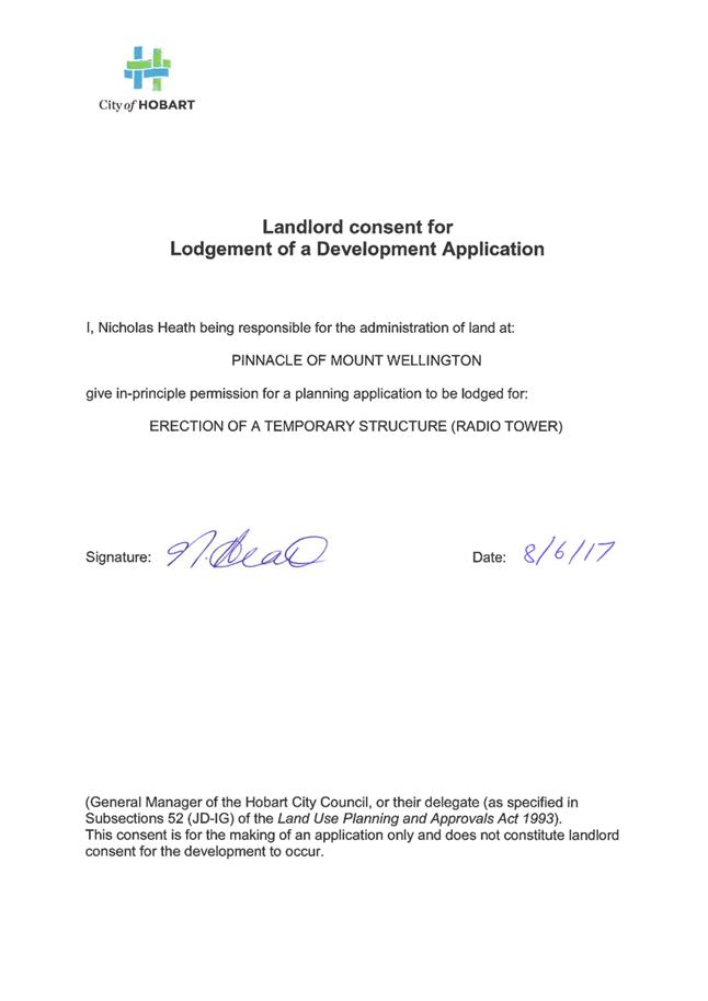
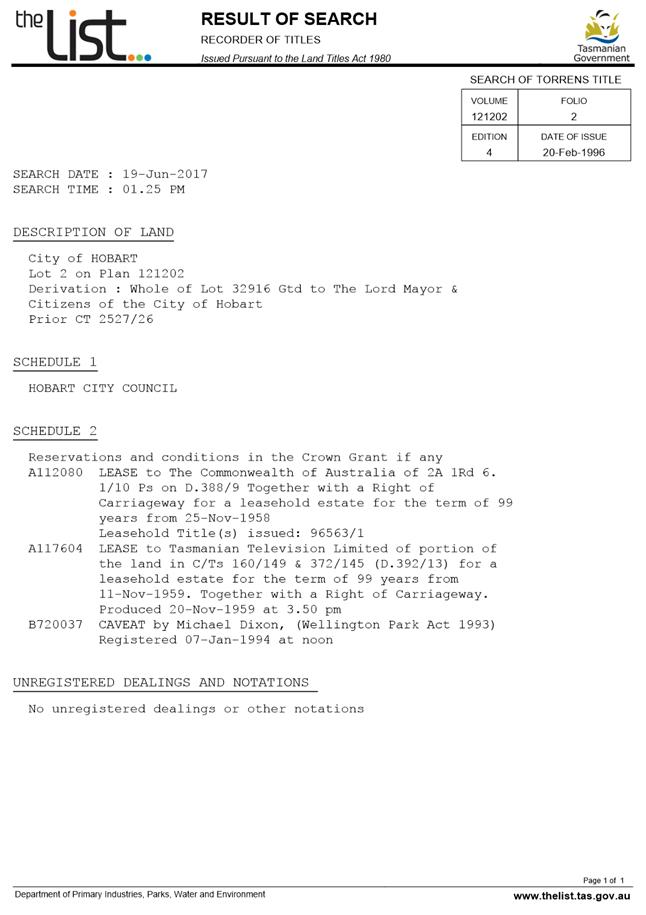
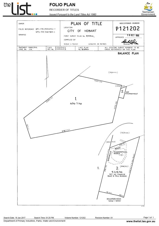
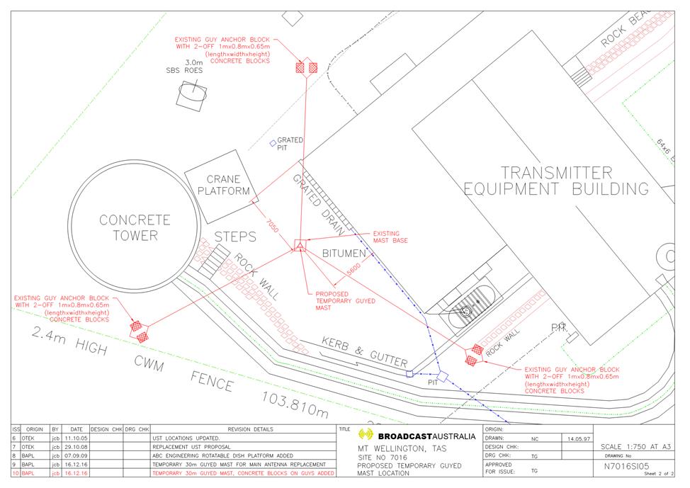
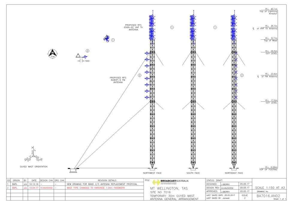
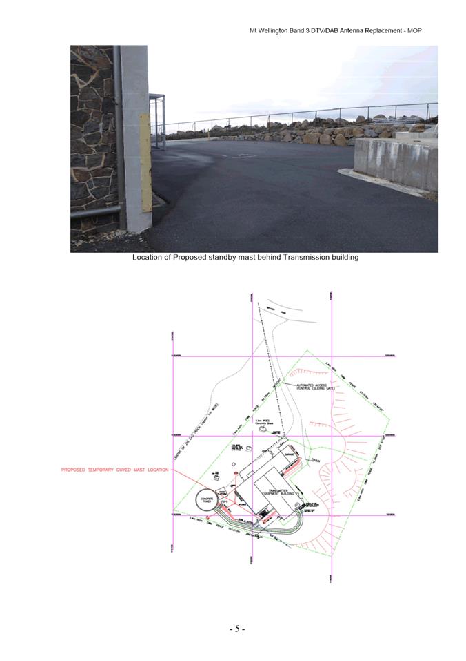
7.1.5 100 Pinnacle Road, Mount Wellington - Works (Temporary Transmission Tower)
pln-17-488
pln-17-488 - FILE REF: F17/96416
Address: 100 Pinnacle Road, Mount Wellington
Proposal: Works (Temporary Transmission Tower)
Expiry Date: 25 September 2017
Extension of Time: Not applicable
Author: Michelle Foale
|
REcommendation Pursuant to the Hobart Interim Planning Scheme 2015, the Council approve the application for Works (Temporary Transmission Tower) at 100 Pinnacle Road, Mount Wellington for the reasons outlined in the officer’s report and a permit containing the following conditions be issued:
GEN
The use and/or development must be substantially in accordance with the documents and drawings that comprise PLN17488 100 PINNACLE ROAD MOUNT WELLINGTON TAS 7054 Final Planning Documents except where modified below.
Reason for condition
To clarify the scope of the permit.
ENG 1
The cost of repair of any damage to the Council infrastructure resulting from the implementation of this permit, must be met by the owners within 30 days of the completion of the development or as otherwise determined by the Council.
A photographic record of the Council infrastructure adjacent to the subject site must be provided to the Council prior to any commencement of works.
A photographic record of the Council’s infrastructure (e.g. existing property service connection points, roads, buildings, stormwater, footpaths, driveway crossovers and nature strips, including if any, pre existing damage) will be relied upon to establish the extent of damage caused to the Council’s infrastructure during construction. In the event that the owner/developer fails to provide to the Council a photographic record of the Council’s infrastructure, then any damage to the Council infrastructure found on completion of works will be deemed to be the responsibility of the owner.
Reason for condition
To ensure that any of the Council infrastructure and/or siterelated service connections affected by the proposal will be altered and/or reinstated at the owner’s full cost.
ENV 1
Sediment and erosion control measures sufficient to prevent sediment from leaving the site must be installed prior to any disturbance of the site. Sediment controls must be maintained until all areas of disturbance have been stabilized or revegetated.
Advice: For further guidance in preparing a Soil and Water Management Plan – in accordance with Fact sheet 3 Derwent Estuary Program click here.
Reason for condition
To avoid the sedimentation of roads, drains, natural watercourses, Council land that could be caused by erosion and runoff from the development, and to comply with relevant State legislation.
ADVICE
The following advice is provided to you to assist in the implementation of the planning permit that has been issued subject to the conditions above. The advice is not exhaustive and you must inform yourself of any other legislation, bylaws, regulations, codes or standards that will apply to your development under which you may need to obtain an approval. Visit the Council's website for further information.
Prior to any commencement of work on the site or commencement of use the following additional permits/approval may be required from the Hobart City Council.
BUILDING PERMIT
Building permit in accordance with the Building Act 2016. Click here for more information.
COUNCIL RESERVES
The applicant is advised that a traffic management plan may be required to address any closures of Pinnacle Road, oversize vehicles movements, and/or public safety concerns associated with the transport of equipment as required for this development. This advice responds to the narrow and winding nature of Pinnacle Road, the alpine environment, and significant tourist traffic.
If required, the traffic management plan must be approved by the Director Parks and City Amenity and the Director Infrastructure Services.
DIAL BEFORE YOU DIG
Click here for dial before you dig information.
WELLINGTON PARK MANAGEMENT TRUST
To ascertain how to gain permission for the development pursuant to the Wellington Park Regulations 2009 and (where relevant for leases and/or licences) sections 31 and 32 of the Wellington Park Act 1993, please contact the Wellington Park Management Trust.
|
Attachment
a: PLN-17-488
- 100 PINNACLE ROAD MOUNT WELLINGTON TAS 7054 - Planning Committee or Delegated
Report ⇩ ![]()
Attachment
b: PLN-17-488
- 100 PINNACLE ROAD MOUNT WELLINGTON TAS 7054 - CPC Agenda Documents ⇩ ![]()
Attachment
c: PLN-17-488
- 100 PINNACLE ROAD MOUNT WELLINGTON TAS 7054 - Parks Planner Referral Report ⇩ ![]()
|
Item No. 7.1.5 |
Agenda (Open Portion) City Planning Committee Meeting - 14/8/2017 |
Page 191 ATTACHMENT a |

|
Agenda (Open Portion) City Planning Committee Meeting - 14/8/2017 |
Page 208 ATTACHMENT b |
|
Item No. 7.1.5 |
Agenda (Open Portion) City Planning Committee Meeting - 14/8/2017 |
Page 216 ATTACHMENT b |
|
Item No. 7.1.5 |
Agenda (Open Portion) City Planning Committee Meeting - 14/8/2017 |
Page 220 ATTACHMENT b |
|
Item No. 7.1.5 |
Agenda (Open Portion) City Planning Committee Meeting - 14/8/2017 |
Page 227 ATTACHMENT c |

|
Item No. 7.2 |
Agenda (Open Portion) City Planning Committee Meeting |
Page 229 |
|
|
14/8/2017 |
|
7.2 Hobart Interim Planning Scheme - Planning Scheme Amendment PSA-17-5 and S43A Permit Application PLN-17-479 - 286 Argyle Street, North Hobart
File Ref: F17/86072; PSA-17-5
Report of the Development Appraisal Planner of 9 August 2017 and attachments.
Delegation: Council
|
Item No. 7.2 |
Agenda (Open Portion) City Planning Committee Meeting |
Page 230 |
|
|
14/8/2017 |
|
REPORT TITLE: Hobart Interim Planning Scheme - Planning Scheme Amendment PSA-17-5 and S43A Permit Application PLN-17-479 - 286 Argyle Street, North Hobart
REPORT PROVIDED BY: Development Appraisal Planner
1. Report Purpose and Community Benefit
1.1. The purpose of this report is to consider an application under the Land Use Planning and Approvals Act 1993 (LUPAA), from Emma Riley and Associates Land Use Planning, on behalf of Mark Drury Architect, to amend the Hobart Interim Planning Scheme 2015 (HIPS 2015) by rezoning the property at 286 Argyle Street from Light Industrial to Inner Residential.
1.2. Pursuant to S43A of the former provisions of LUPAA, the planning scheme amendment application is combined with a planning permit application for partial demolition, alterations, signage and change of use to twelve multiple dwellings (PLN-17-479). The Development Appraisal Planner’s report is provided in Attachment A, and the applicant’s submission in support of the rezoning, plans and TasWater’s response is provided in Attachment B.
1.3. The proposal benefits the community by ensuring that land is appropriately zoned and that development is undertaken in a fair and orderly manner.
2. Report Summary
2.1. The proposal is to rezone a site (two lots) at 286 Argyle Street, North Hobart, from Light Industrial to Inner Residential.
2.2. A development application for partial demolition, alterations, signage and change of use to twelve multiple dwellings has also been submitted, and will be considered concurrently with the proposed amendment.
2.3. The subject site currently contains a vacant building, which was most recently used by a performing arts organisation, and before that for the sale of bulky goods. This building is to be retained and converted to twelve new multiple dwellings.
2.4. The subject site is located between Argyle and Elizabeth Streets, within close proximity to the North Hobart restaurant strip, the city, and high frequency public transport corridors.
2.5. The site is located in a one lot deep strip of Light Industrial zoning, surrounded by Inner Residential zoned land. The surrounding area is characterised by a mix of uses including single dwellings, multiple dwellings, large floor area light industrial uses, and community uses such as a church and a public park.
2.6. The proposed rezoning is considered to be an appropriate amendment to the HIPS 2015 for the following reasons:
2.6.1. The Inner Residential Zone encourages residential densification in appropriately sited areas. The site is well located for higher density residential development given its accessibility, proximity to services and adjacency to existing Inner Residential zoned land.
2.6.2. Removing a small area of the Light Industrial Zone is not considered to impede the operation of that zone (which is already limited in extent within the Hobart Municipal Area, and limited in usability given the surrounding land use).
2.6.3. The rezoning supports the policies of the Southern Tasmania Regional Land Use Strategy (STRLUS) to increase dwelling density within close proximity of Integrated Transit Corridors (Elizabeth Street), and to use infill development as a significant means to achieve dwelling density targets.
2.7. The development application is considered in detail in Attachment A.
2.8. The planning scheme amendment and associated development application are recommended for approval.
|
That: 1. Pursuant to Section 34(1) (a) of the former provisions of the Land Use Planning and Approvals Act 1993, the Council resolve to initiate an amendment to the Hobart Interim Planning Scheme 2015 to rezone the property at 286 Argyle Street North Hobart from Light Industrial to Inner Residential, as indicated on the plans provided in Attachment B. 2. Pursuant to Section 35 of the former provisions of the Land Use Planning and Approvals Act 1993, the Council certify that the PSA-17-5 Amendment to the Hobart Interim Planning Scheme meets the requirements of Section 32 of the former provisions of the Land Use Planning and Approvals Act 1993 and authorise the General Manager and the Deputy General Manager to sign the Instrument of Certification (Attachment C). 3. Pursuant to Section 38 of the former provisions of the Land Use Planning and Approvals Act 1993, the Council place the PSA-17-5 Amendment to the Hobart Interim Planning Scheme 2015 on public exhibition for a 28 day period following certification. 4. Pursuant to Section 43A of the former provisions of the Land Use Planning and Approvals Act 1993, the Council grant a permit for partial demolition, alterations, signage and change of use to twelve multiple dwellings at 286 Argyle Street, North Hobart and a permit containing the conditions specified in Attachment A be issued. |
4. Background
Existing Situation
4.1. The land subject to the proposed rezoning (286 Argyle Street, North Hobart) is a fully serviced and fully sealed 811m2 site, comprised of two titles, that are currently zoned Light Industrial.
4.2. The site is located within a strip of Light Industrial zoned land, but is adjacent to and opposite Inner Residential zoned land, in an area which is slowly evolving to be predominantly residential in use. The area is characterised generally by older houses on small lots or multiple dwellings, and in the Light Industrial Zone, characterised by large floor area commercial buildings.
4.3. The site contains a brick warehouse which occupies the entire site.
4.4. Land uses in the immediate area are mixed – predominantly residential to the west and east of the site and commercial immediately to the north and south along Argyle Street. Uses directly adjoining the site include a car yard, an electrical appliance repairs and sales shop, and an approved, as yet un-commenced multiple dwelling development to the west. Opposite the site is a cafe.
4.5. A site investigation submitted by the applicant reveals that there is no evidence of contaminating activities having occurred on the site.
Soil testing has identified that there is a low risk to all present and potential future onsite inhabitants, and there is low risk of off-site contamination from the site into the future.
The site investigation concludes that, as a precaution, any excavated material should be stockpiled and inspected to ensure that there is no undiscovered complication with the development of the site.
4.6. The subject site is within the 200m attenuation distance of a late night entertainment venue (199 Elizabeth Street – the Republic Hotel) under the Attenuation Code of the HIPS 2015.
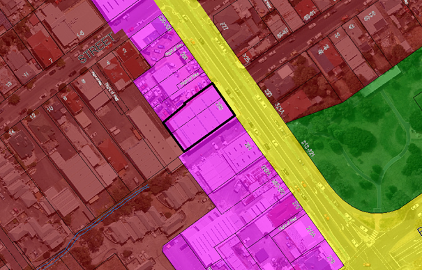
Figure 1: Subject site (outlined in black) showing existing zoning (maroon: Inner Residential, pink: Light Industrial).
Planning Scheme Provisions
4.7. The Zone Purpose Statements for the Light Industrial Zone are:
To provide for manufacturing, processing, repair, storage and distribution of goods and materials where off-site impacts are minimal or can be managed to minimise conflict or impact on the amenity of any other uses.
To promote efficient use of existing industrial land stock.
To minimise land use conflict in order to protect industrial viability and the safety and amenity of sensitive land uses in adjacent zones.
To ensure that building design and form enhances the streetscape and protects the amenity of the neighbourhood.
4.8. Within the Light Industrial Zone, any permitted use can be no permit required if there is no associated development that requires a permit. Permitted uses are equipment and machinery sales and hire, manufacturing and processing, service industry and storage. Discretionary uses include (but are not limited to) food services (if cafe or take away), research and development, transport depot and distribution and vehicle fuel sales and service. Residential uses are prohibited unless for a caretakers dwelling, home based business or extension of an existing dwelling/ancillary dwelling.
4.9. There are a number of use standards that control the impact of uses in the Light Industrial zone, where they are in proximity to a residential zone. Development standards generally relate to the form, function, safety and attractiveness of commercial buildings.
4.10. The Zone Purpose Statements for the Inner Residential Zone are:
To provide for a variety of residential uses and dwelling types close to services and facilities in inner urban and historically established areas, which uses and types respect the existing variation and pattern in lot sizes, set back and height.
To provide for compatible non-residential uses that primarily serve the local community.
To encourage residential development at higher densities in locations within walkable distance of services, facilities, employment and high frequency public transport corridors.
To encourage residential development that respects the neighbourhood character.
To provide a high standard of residential amenity.
To allow commercial uses which provide services for the needs of residents of a neighbourhood and do not displace an existing residential use or adversely affect their amenity particularly through noise, traffic generation and movement, and the impact of demand for on-street parking.
4.11. Within the Inner Residential Zone, single dwellings are no permit required, with other residential use classes (except more intense home based businesses) and visitor accommodation permitted. Some non-residential uses such as food services, general retail and hire and limited business and professional services uses are discretionary in the event that they do not displace residential uses. A number of community uses such as community meeting and entertainment, educational and occasional care, emergency services and sport and recreation are also discretionary.
4.12. Use standards and development standards are aimed towards protecting residential amenity, although they encourage a relatively high density of residential development.
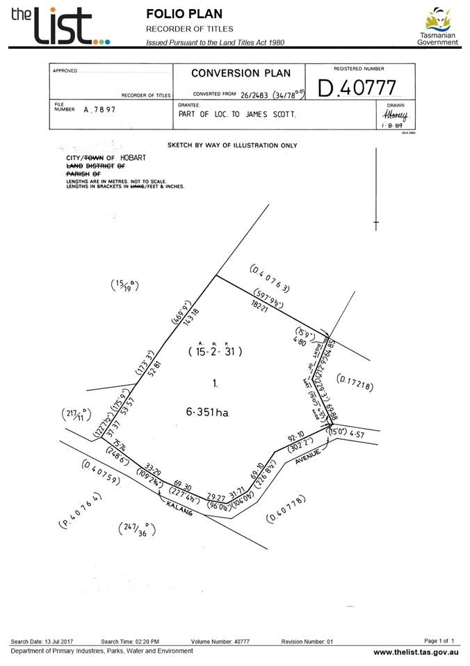
5. Proposal and Implementation
5.1. The proposal is to rezone the site which is comprised of two titles (CT-9228/1 and CT-65899/2) at 286 Argyle Street, North Hobart to Inner Residential to enable residential development. The area proposed to be rezoned is shown in Figure 2 below.
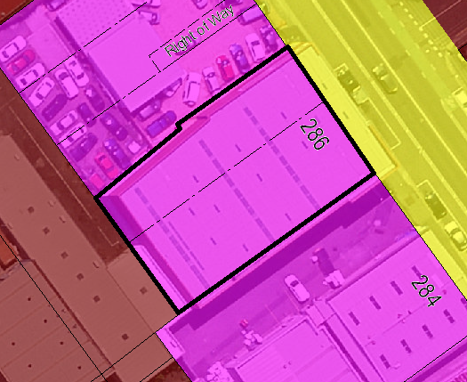
Figure 2: 286 Argyle Street, the site to be re-zoned from Light Industrial to Inner Residential is outlined in black.
5.2. It is also proposed that planning approval be granted for the redevelopment of the site by way of partial demolition, alterations, signage and change of use to twelve multiple dwellings, under S.43A of the former provisions of LUPAA. The former provisions of the Act are defined in Schedule 6 – Savings and Transitional Provisions of the Land Use Planning and Approvals Amendment (Tasmanian Planning Scheme Act) 2015 which commenced on 17 December 2015. An assessment of the S.43A application by a Development Appraisal Planner and the Senior Statutory Planner is provided in Attachment A.
5.3. In relation to 5.2 above, LUPAA allows for Council, after it has decided to initiate an amendment, to consider a permit application concurrently with the preparation of a requested amendment. Both the amendment and permit application would be advertised for public comment. If Council decides not to initiate the amendment requested there is no need to consider the planning permit application.
Justification – Applicant’s Submission
5.4. The applicant considers that the requested amendment is justified for the following reasons:
5.4.1. The site is currently underutilised, having not been used for industrial purposes for approximately two years.
5.4.2. The Southern Tasmanian Regional Land Use Strategy (STRLUS) encourages densification through greater efficiency in the use of land for residential development, and particularly focuses on the benefits of infill development.
5.4.3. The subject site is within a designated Densification Area identified in the STRLUS, and meets many of the STRLUS policies, specifically the following:
5.4.3.1. The proposed amendment amounts to rezoning of less than 0.1 hectare of industrial land. This amount of land is comparatively negligible in the context of the supply and demand of land for local services industries. Furthermore, the land to be rezoned, while accessible off an arterial road is smaller than typically required for local service industries today with a higher land value than generally desirable.
5.4.3.2. The City of Hobart already relies on adjoining municipal areas to meet its service industry supply shortfall. Given the recent development of the Brighton Industrial Hub and the Cambridge Park Industrial Estate, larger industrial uses are re-locating to these areas, providing increased capacity for Glenorchy to accommodate service industries to compensate for the shortfall within the City of Hobart. This reliance on adjacent municipalities for service industry provisions is a trend seen throughout Australia.
5.4.3.3. In this context it is considered that the proposed amendment will not offend Regional Policy IA1.
5.4.3.4. Moreover, the proposed amendment directly furthers the attainment of the Settlement and Residential Development policies.
5.4.3.5. Specifically, the proposal is considered to be consistent with SRD 2.1, SRD 2.6, SRD 2.7 and SRD 2.9.
5.4.3.6. The subject land is located within the densification area. It is located only 200 metres (270 metres walking distance using existing road network) from the transit corridor along Elizabeth Street. It adjoins existing inner residential areas, including land at 4 Lefroy Street which was recently rezoned from Light Industrial to Inner Residential.
5.4.3.7. The rezoning of the subject land to Inner Residential will increase the supply of dwellings within the regionally identified densification area. As a brownfield site it will present an opportunity to contribute to a mix of dwelling types within the area due to the existing building form, also furthering Regional Policy SRD2.9.
5.4.4. The proposed planning scheme amendment meets the requirements of Schedule 1 of LUPAA, State Policies, National Environmental Protection Measures and the Gas Pipelines Act 2000.
Justification - Comment
5.5. The existing light industrial zoning of the land is reflective of the historical land use of the area, rather than any strategic assessment or direction.
5.6. The applicant has submitted some valid reasons supporting the proposed rezoning.
5.7. The subject site is well located in terms of access to transport and services, and can be considered a good example of a site where higher density development should be encouraged.
5.8. A potential issue with the proposed rezoning is the loss of land in the Light Industrial Zone, which is already very limited in extent. The zone provides for legitimate uses to remain in the Hobart municipality, within an area historically developed for light industrial purposes.
5.9. The removal of this small area of Light Industrial Zone (811m2) is not considered to significantly impact on the operation or opportunities of that zone. In any event, it is likely that more intensive light industrial uses would be inappropriate given the potential for land use conflict with uses allowed in the residentially zoned area adjacent to and extending from the rear of the site.
5.10. A consideration for the rezoning is the fact that the subject site is within the attenuation distance of 200m from a late night entertainment venue (The Republic Hotel), as stipulated under the Attenuation Code of the HIPS 2015. The site is on the outer edge of the attenuation distance. Given North Hobart is an established residential area with many residences in much closer proximity to this use than the subject site, the rezoning is not considered unreasonable. The Attenuation Code will apply to residential development on the site, and will require consideration of the potential effects of the late night entertainment venues.
5.11. Uses within the Light Industrial Zone are exempt from consideration under the Attenuation Code, to ensure uses within those zones are able to operate in line with the Zone Purpose. North Hobart is a unique circumstance in that the Light Industrial Zone is surrounded by the Inner Residential Zone, and therefore inherently poses more potential for land use conflict between zones. However, the mixed use environment of this area of North Hobart is well established, and the rezoning will not introduce a significant change to the current circumstances.
5.12. In the case of the subject site, the rezoning will allow for a greater density of residential development directly adjacent to the Light Industrial Zone. The site is located between 2 sites containing existing non-residential uses (household electrical repairs and sales, and a car yard and warehouse/showroom within the Light industrial Zone), and one site with approved, as yet un-commenced residential use and development.
There is obviously some potential for land use conflict between the subject site and adjacent uses. This is considered to be acceptable for the reasons outlined above.
5.13. Residential densification in this area of Hobart, which is close to the city as well as to the services of the North Hobart restaurant and shopping strip, is a desirable outcome. Allowing for a consolidated redevelopment to utilise the entire ‘brownfield’ site efficiently assists in achieving the residential densification targets of the STRLUS.
5.14. The site is also within 200m of an integrated transit corridor (Elizabeth Street). The STRLUS targets densification in areas within a distance of 400-800m of integrated transit corridors (subject to heritage constraints), and as such the site is considered to be a primary location for dense residential development, which will be facilitated by an Inner Residential zoning.
5.15. Given the site represents a redevelopment opportunity, classed as ‘infill’ development, this further satisfies the policies of the STRLUS, which recognise the social, environmental and economic benefits of maximising infill opportunities to deliver a varied range of household options that allow for more sustainable lifestyles.
6. Strategic Planning and Policy Considerations
6.1. The proposed amendment is consistent with the objectives of the Capital City Strategic Plan 2015-2025 in regard to Strategic Objective 2.3 – ‘City and regional planning ensures quality design, meets community needs and maintains residential amenity’.
7. Financial Implications
7.1. The proposed planning scheme amendment should not result in any additional significant Council expenditure.
8. Legal, Risk and Legislative Considerations
8.1. The Land Use Planning and Approvals Act 1993 (LUPAA) requires that planning scheme amendments must seek to further the objectives of Schedule 1 of the Act and be prepared in accordance with State Policies.
8.2. The objectives of the Act require use and development to occur in a fair, orderly and sustainable manner and for the planning process to facilitate economic development in accordance with the other Schedule 1 objectives.
8.3. It is considered that the proposed amendment meets the objectives of LUPAA, in particular it:
8.3.1. Assists sound strategic planning by not prejudicing the achievement of the relevant Zone Objectives or the STRLUS objectives;
8.3.2. Is consistent with the objective to establish a system of planning instruments to be the principal way of setting objectives, policies and controls for the use, development and protection of land;
8.3.3. Provides greater flexibility to address changes in local environmental, social and economic circumstances;
8.3.4. Allows for a more efficient use of the existing infrastructure and facilities;
8.3.5. Is consistent with the objective to provide for the consolidation of approvals for land use and development;
8.3.6. Facilitates the integration of compatible and complementary land use activities in a managed and safe environment;
8.3.7. Provides for the exercise of greater flexibility to fully consider the capability of the land.
8.4. The relevant State Policy to consider in this case is the State Policy on Water Quality Management. It is considered that the proposed amendment is consistent with the objectives of this policy as a soil and water management plan will be required for future development on the site, and stormwater will be drained to an existing piped system.
8.5. S32(e) of the former provisions of LUPAA requires that planning scheme amendments must avoid the potential for land use conflicts in adjacent planning scheme areas. The amendment essentially relocates the boundary of the Light Industrial Zone, and reduces the overall amount of land in that zone. It is well established in North Hobart that residential development may abut light industrial development, and the amendment only slightly moves the interface between the two zones, thus not increasing the potential for conflict compared to the current situation. The Light Industrial Zone Use Standards also act to limit impacts on residential amenity in relation to operating hours, noise, external lighting, outdoor work areas and vehicle movements in proximity to a residential zone.
8.6. S32(f) of the former provisions of LUPAA requires that planning scheme amendments must have regard to the impact that the use and development permissible under the amendment will have on the use and development of the region as an entity in environmental, economic and social terms. The size, location and configuration of the land proposed for rezoning is such that it will not have any regional implications.
8.7. Section 30O of LUPAA requires that an amendment to an interim planning scheme is as far as practicable, consistent with the regional land use strategy. The proposed amendment is consistent with the relevant STRLUS policies as outlined in section 5 of this report.
9. Environmental Considerations
9.1. The site is an underutilised area of land within close proximity to services and transport, and therefore efficient development of the land is considered to provide for a positive environmental outcome.
10. Social and Customer Considerations
10.1. The proposal is not considered to have any negative impact on social inclusion.
11. Marketing and Media
11.1. There are no marketing or branding implications of this amendment.
12. Community and Stakeholder Engagement
12.1. Council has requested that reports which recommend the initiation of planning scheme amendments address the need to conduct a public meeting or forum to explain the proposed amendments and also outline the explanatory information to be made available. These are addressed below:
12.1.1. It is not considered that a public forum is necessary to explain the proposed amendment to the public as it is relatively simple and self explanatory.
12.1.2. The following information will be made available on the website: a copy of this report, a copy of the formal amendment document and the applicant’s submission.
12.2. Council will have the opportunity to recommend to the Tasmanian Planning Commission modifications or refusal of the permit or amendment after the 28 day public advertising period.
13. Delegation
13.1. Delegation rests with the Council.
As signatory to this report, I certify that, pursuant to Section 55(1) of the Local Government Act 1993, I hold no interest, as referred to in Section 49 of the Local Government Act 1993, in matters contained in this report.
|
Helen Ayers Development Appraisal Planner |
|
Date: 9 August 2017
File Reference: F17/86072; PSA-17-5
Attachment a: Development
Application Assessment Report ⇩ ![]()
Attachment
b: Application
Report and Plans (Supporting information) ![]()
|
Item No. 7.2 |
Agenda (Open Portion) City Planning Committee Meeting - 14/8/2017 |
Page 242 ATTACHMENT a |
|
Agenda (Open Portion) City Planning Committee Meeting |
Page 271 |
|
|
|
14/8/2017 |
|
8 Reports
8.1 Hobart Interim Planning Scheme 2015 - Sullivans Cove Planning Scheme 1997 - Proposed Amendment - Royal Hobart Hospital Helipad Airspace Specific Area Plan
File Ref: F17/87761; PSA
Report of the Manager Planning Policy and Heritage and the Director City Planning of 9 August 2017 and attachments.
Delegation: Council
|
Item No. 8.1 |
Agenda (Open Portion) City Planning Committee Meeting |
Page 272 |
|
|
14/8/2017 |
|
REPORT TITLE: Hobart Interim Planning Scheme 2015 - Sullivans Cove Planning Scheme 1997 - Proposed Amendment - Royal Hobart Hospital Helipad Airspace Specific Area Plan
REPORT PROVIDED BY: Manager Planning Policy and Heritage
Director City Planning
1. Report Purpose and Community Benefit
1.1. This report considers a proposal to amend both the Hobart Interim Planning Scheme 2015 (HIPS2015) and the Sullivans Cove Planning Scheme 1997 (SCPS1997) pursuant to Section 34 of the former provisions of the Land Use Planning and Approvals Act 1993 (LUPAA).
1.2. The proposed amendment is to insert a Specific Area Plan to ensure that development in the vicinity of the proposed Royal Hobart Hospital (RHH) helipad does not obstruct safe air navigation. A copy of the submission on behalf of the RHH Redevelopment Project in support of the amendment is provided in Attachment A.
1.3. The purpose of this report is to consider the initiation and subsequent certification of the proposed amendment pursuant to Sections 32 and 35 of the LUPAA.
1.4. The proposal benefits the community by ensuring that air ambulance access to the RHH is maintained.
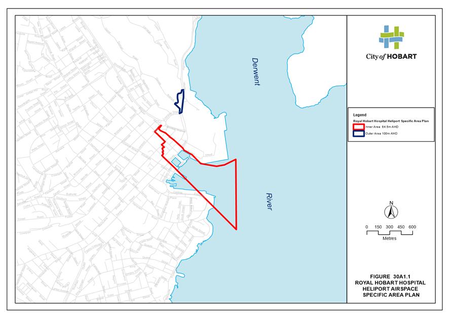
2. Report Summary
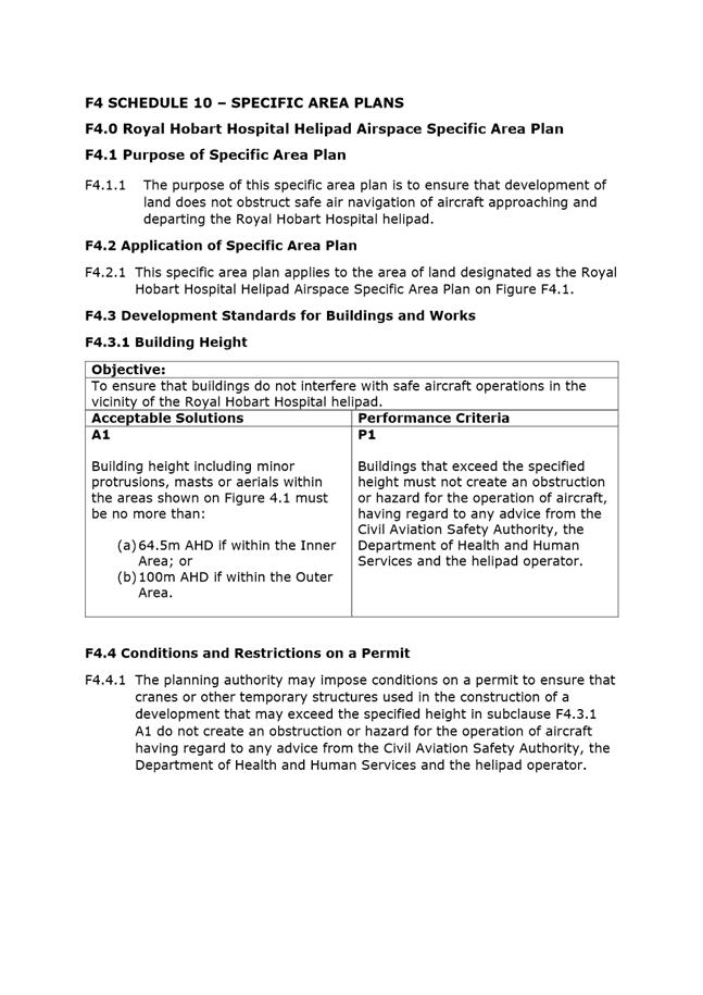
2.1. This report considers a proposal to amend both the Hobart Interim Planning Scheme 2015 (HIPS2015) and the Sullivans Cove Planning Scheme 1997 (SCPS1997) to insert a Specific Area Plan to ensure that development in the vicinity of the proposed Royal Hobart Hospital (RHH) helipad does not obstruct safe air navigation. A copy of the submission on behalf of the RHH Redevelopment Project in support of the amendment is provided in Attachment A.
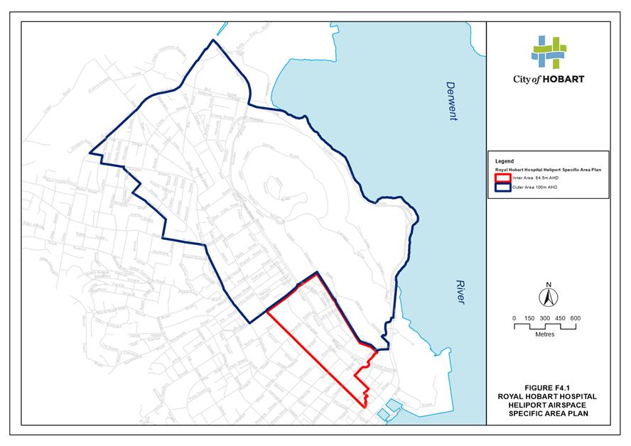
2.2. The specific area plan applies to the area of land designated as the Royal Hobart Hospital Helipad Airspace Specific Area Plan shown on the figure within the plan. The figure designates an inner and an outer area.
2.3. The acceptable solution provides that within the inner area building height including minor protrusions, masts or aerials must be no more than 64.5m AHD and if within the outer area no more than 100m AHD.
2.4. Under the related performance criteria, buildings that exceed the height specified in the acceptable solution, must not create an obstruction or hazard for the operation of aircraft, having regard to any advice from the Civil Aviation Safety Authority, the Department of Health and Human Services and the helipad operator.
2.5. The specific area plan also provides for the Council to impose conditions on a permit to ensure that cranes or other temporary structures used in the construction of a development, that may exceed the height specified in the acceptable solution, do not create an obstruction or hazard for the operation of aircraft.
|
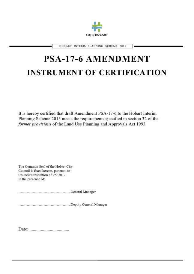
That: 1. Pursuant to Section 34(1) (b) of the former provisions of the Land Use Planning and Approvals Act 1993, Council resolve to initiate the following amendments: (i) Amendment PSA-17-6 to the Hobart Interim Planning Scheme 2015 as detailed in Attachment B; and (ii) Amendment PSA-17-7 to the Sullivans Cove Planning Scheme1997 as detailed in Attachment C. 2. Pursuant to Section 35 of the former provisions of the Land Use Planning and Approvals Act 1993, Council certify that Amendment PSA-17-6 to the Hobart Interim Planning Scheme 2015 and Amendment PSA-17-7 to the Sullivans Cove Planning Scheme 1997 meets the requirements of Section 32 of the former provisions of the Land Use Planning and Approvals Act 1993 and authorise the General Manager and the Deputy General Manager to sign the Instruments of Certification (Attachments D&E). 3. Pursuant to Section 38 of the former provisions of the Land Use Planning and Approvals Act 1993, Council place Amendment PSA-17-6 to the Hobart Interim Planning Scheme 2015 and Amendment PSA-17-7 to the Sullivans Cove Planning Scheme 1997 on public exhibition for a 28 day period following certification.
|
4. Background
4.1. In December 2015, the Council approved a planning permit application for the development of a helipad on the roof of the approved but yet to be constructed RHH K Block building, near the Campbell Street frontage of the site and approximately halfway between Liverpool and Collins Streets.
4.2. The RHH site is within the Particular Purpose Zone 10 – Royal Hobart Hospital Campus under the HIPS 2015.
4.3. The Zone Purpose Statements under Clause 41.1.1 state as follows:
4.3.1. To recognise the important economic and social role played by the Royal Hobart Hospital and the critical health care benefits to the community in having a strong functioning hospital within easy reach (of) a substantial population.
4.3.2. To recognise the central city context within which the hospital is situated and the reality that built form may not be consistent with the scale of development in the surrounding area due to site constraints and the need to ensure that the hospital provides the range of services required by the community.
4.3.3. To ensure the facility is primarily used as a hospital with ancillary hospital outpatient facilities and uses which provide services to users of the hospital.
4.4. The acceptable solution for height within Clause 41.4.1 A1 requires development and works other than minor protrusions to be within the building envelope shown in Figure 41.1 of the Hobart Interim Planning Scheme 2015. The maximum height for the relevant part of the site where the helipad is located is RL +68.74.
4.5. In the HIP2015 area the helicopter flight paths extend over a number of zones including; Central Business, Commercial, Light Industrial, Urban Mixed Use, Utilities, Open Space, Recreation and Inner Residential Zones.
4.6. There are a range of permitted and discretionary height standards in these zones however none of those standards specify an absolute maximum height for buildings and structures.
4.7. In the SCPS1997 area the helicopter flight paths extend over activity areas 1.0 Inner City Residential (Wapping), 2.0 Sullivans Cove Mixed Use and 4.3 Sullivans Cove – Working Port.
4.8. Height in the SCPS1997 is controlled through Schedule 2 Urban Form. Permitted building heights in various parts of the Cove are identified on Figure 8. Again no absolute maximum height is specified in this Scheme.
5. Proposal and Implementation
5.1. It is proposed that Council initiate an amendment to both the Hobart HIPS2015 and the SCPS1997 to insert a Specific Area Plan to ensure that development in the vicinity of the proposed RHH helipad does not obstruct safe air navigation.
5.2. The RHH Redevelopment Project has prepared an assessment of the airspace protection requirements for the RHH rooftop heliport operations (Attachment A).
5.3. That assessment advises that the heliport has been planned and designed to facilitate the operation of Medical Transport helicopter flights in Performance Class 1, the operational criteria nominated in a Notice of Proposed Rule Making issued by the Civil Aviation Safety Authority. The proposed changes to the regulatory regime for helicopters engaged in ambulance function flights will classify such flights as Air Transport operations in line with international practice and require compliance with prescribed operational criteria.
5.4. Flights operating in Performance Class 1 need by definition to be conducted with multi-engine helicopters that have identified performance capabilities with one engine inoperative (OEI). Performance Class 1 fights are fully accountable through all phases of flight. The term fully accountable refers to the ability of a helicopter in an OEI situation to make a safe landing at the helipad or to fly away and remain above obstacles along the flightpath by at least 35 feet (10.7 metres).
5.5. The ability to operate in Performance Class 1 requires the establishment and maintenance of obstacle free airspace either side of a flightpath track. Whilst the current extent of high rise building development in the Hobart CBD above the level of the hospital rooftop helipad can be considered modest, given the absence of absolute height limits in the Planning Schemes, the potential exists for future developments to occur which may affect the operational viability of the rooftop helipad if such developments intrude into the operational airspace for the heliport.
5.6. It is possible however to identify the operational airspace for the Royal Hobart Hospital rooftop helipad with protection of the airspace against obstacle intrusion through relevant provisions within the HIPS2015 and SCPS1997. It is suggested in the RHH assessment report that a planning provision equivalent to the Design and Development Overlay mechanism successfully adopted in Victoria would achieve the desired protection measures.
5.7. The primary flightpath tracks and associated airspace for flights to and from the Royal Hobart Hospital heliport have been identified with reference to site specific wind data generated by The Air Pollution Model (TAPM). The wind data analysis indicates a dominance of winds from the NNW leading to the conclusion that the primary flightpath track to and from the heliport will be in the NW-SE direction, approximately aligned with Campbell Street and the longitudinal axis of the proposed RHH K Block development.
5.8. Analysis of the existing terrain and alternate flightpath tracks, including tracking options in response to an OEI situation and the relative location of water areas that present options for overflight based on Fly Neighbourly principles has also been undertaken to identify the overall region where helicopter overflight may occur.
5.9. Figure 7 in the RHH Redevelopment Project report (Attachment A) presents details of the nominated boundaries for the inner protection area with a nominated elevation of 64.5m AHD with the boundary adjusted to align with streets to assist in the boundary definition. The boundary for the inner area has been aligned with Argyle Street.
5.10. Figure 8 in the report presents the nominated boundaries of the outer area with a nominated elevation of 100m AHD with the boundary adjusted to align with streets to assist in the boundary definition.
5.11. The lateral boundary of the region defined by the flightpath airspace also incorporates a lateral expansion of 60 metres to take account of the potential for developments outside the airspace boundary to utilize large cranes during construction. The 60m buffer protects helicopter operations against the possibility that such cranes could swing into the defined region of the operational airspace.
5.12. Implementation of the proposed amendments is by way of the insertion of a specific area plan in each of the HIPS2015 and the SCPS1997.
5.13. The purpose of the specific area plan is to ensure that development of land does not obstruct safe air navigation of aircraft approaching and departing the Royal Hobart Hospital helipad.
5.14. The specific area plan applies to the area of land designated as the Royal Hobart Hospital Helipad Airspace Specific Area Plan shown on the figure within the plan. The figure designates an inner and an outer area.
5.15. The acceptable solution provides that within the inner area building height including minor protrusions, masts or aerials must be no more than 64.5m AHD and if within the outer area no more than 100m AHD.
5.16. Under the related performance criteria, buildings that exceed the height specified in the acceptable solution, must not create an obstruction or hazard for the operation of aircraft, having regard to any advice from the Civil Aviation Safety Authority, the Department of Health and Human Services and the helipad operator.
5.17. The specific area plan also provides for Council to impose conditions on a permit to ensure that cranes or other temporary structures used in the construction of a development, that may exceed the height specified in the acceptable solution, do not create an obstruction or hazard for the operation of aircraft having regard to any advice from the Civil Aviation Safety Authority, the Department of Health and Human Services and the helipad operator.
5.18. There are no current applications for taller buildings or structures within the inner or outer airspace protection areas.
6. Strategic Planning and Policy Considerations
6.1. The proposed planning scheme amendments will assist in the achievement of the strategic objectives of the Capital City Strategic Plan 2015-2025 particularly in relation to Goal 4 Strong, Safe and Healthy Communities - 4.3 "Build community resilience, public health and safety."
7. Financial Implications
7.1. Funding Source and Impact on Current Year Operating Result
7.1.1. The planning scheme amendments do not have any financial implications.
7.2. Impact on Future Years’ Financial Result
7.2.1. None
7.3. Asset Related Implications
7.3.1. None
8. Legal, Risk and Legislative Considerations
8.1. The Land Use Planning and Approvals Act 1993 (LUPAA) requires that planning scheme amendments must seek to further the objectives of Schedule 1 of the Act and be prepared in accordance with State Policies.
8.2. The objectives of the Act require use and development to occur in a fair, orderly and sustainable manner and for the planning process to facilitate economic development in accordance with the other Schedule 1 objectives.
8.3. It is considered that the proposed amendment meets the objectives of LUPAA, in particular it:
8.3.1. Is the result of co-ordinated action by State and local government;
8.3.2. Is consistent with the objective to establish a system of planning instruments to be the principal way of setting objectives, policies and controls for the use, development and protection of land as it will support the efficient operation of an important public facility;
8.3.3. Acts to protect public infrastructure and facilities for the benefit of the community.
8.4. Given the nature of the amendment it is not considered to be in conflict with any of the existing State Policies.
8.5. S32(e) of the former provisions of LUPAA require that planning scheme amendments must avoid the potential for land use conflicts in adjacent planning scheme areas. The proposed amendment should act to limit the potential for land use conflict by restricting building height within the helicopter flight paths.
8.6. S32(f) of the former provisions of LUPAA require that planning scheme amendments must have regard to the impact that the use and development permissible under the amendment will have on the use and development of the region as an entity in environmental, economic and social terms. The amendments will support the operation of a regional health facility.
8.7. Section 30O of LUPAA requires that an amendment to an interim planning scheme is as far as practicable, consistent with the regional land use strategy. The proposed amendment is consistent with the Southern Tasmania Regional Land Use Strategy Policy; S1.1. Recognise the significance of the Royal Hobart Hospital and support, through planning scheme provisions its ongoing function and redevelopment in its current location.
9. Community and Stakeholder Engagement
9.1. Council has requested that reports which recommend the initiation of planning scheme amendments address the need to conduct a public meeting or forum to explain the proposed amendments and also outline the explanatory information to be made available. These are addressed below:
9.1.1. It is not considered that a public forum is necessary to explain the proposed amendment to the public as it is relatively straight forward and self-explanatory.
9.1.2. The following information will be made available on the website: a copy of this report and a copy of the formal amendment document.
9.2. Council will have the opportunity to recommend to the Tasmanian Planning Commission modifications or refusal of the amendment after the 28 day public advertising period.
10. Delegation
10.1. Delegation rests with the Council.
As signatory to this report, I certify that, pursuant to Section 55(1) of the Local Government Act 1993, I hold no interest, as referred to in Section 49 of the Local Government Act 1993, in matters contained in this report.
|
James McIlhenny Manager Planning Policy and Heritage |
Neil Noye Director City Planning |
Date: 9 August 2017
File Reference: F17/87761; PSA
Attachment a: RHH
Helipad Airspace Protection Requirements Report ⇩ ![]()
Attachment
b: HIPS2015
RHH Helipad Airspace Specific Area Plan ⇩ ![]()
Attachment
c: SCPS
1997 RHH Helipad Airspace Specific Area Plan ⇩ ![]()
Attachment
d: HIPS2015
Instrument of Certification ⇩ ![]()
Attachment
e: SCPS1997
Instrument of Certification ⇩ ![]()
|
Item No. 8.1 |
Agenda (Open Portion) City Planning Committee Meeting - 14/8/2017 |
Page 279 ATTACHMENT a |
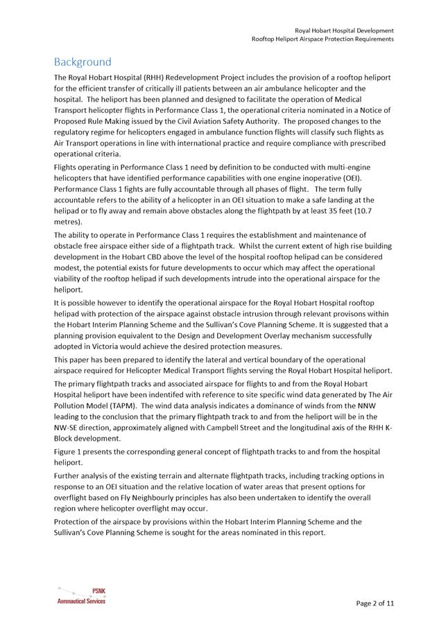
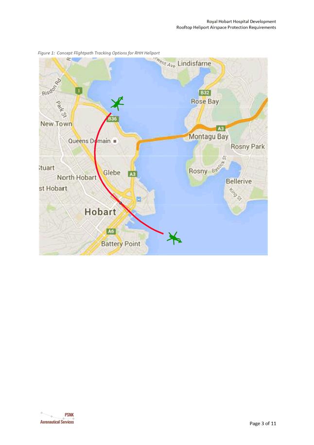
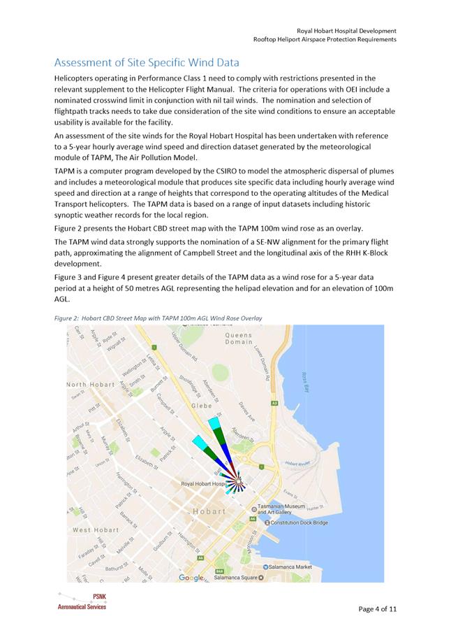
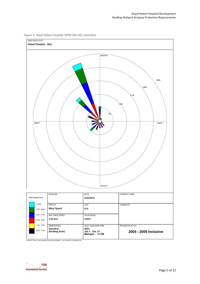
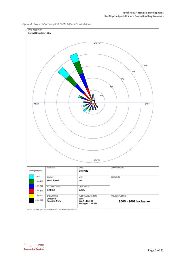
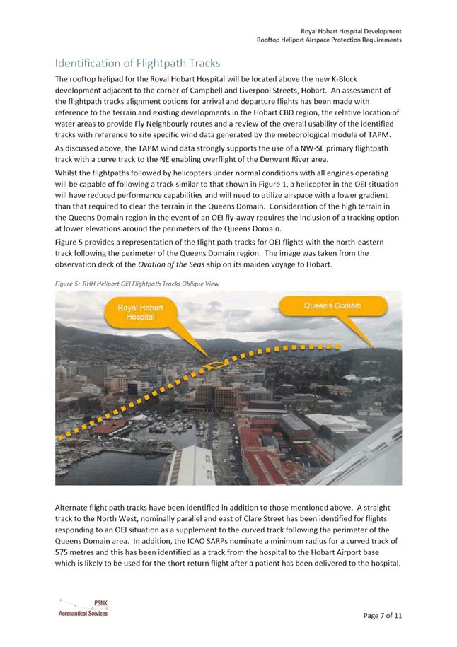
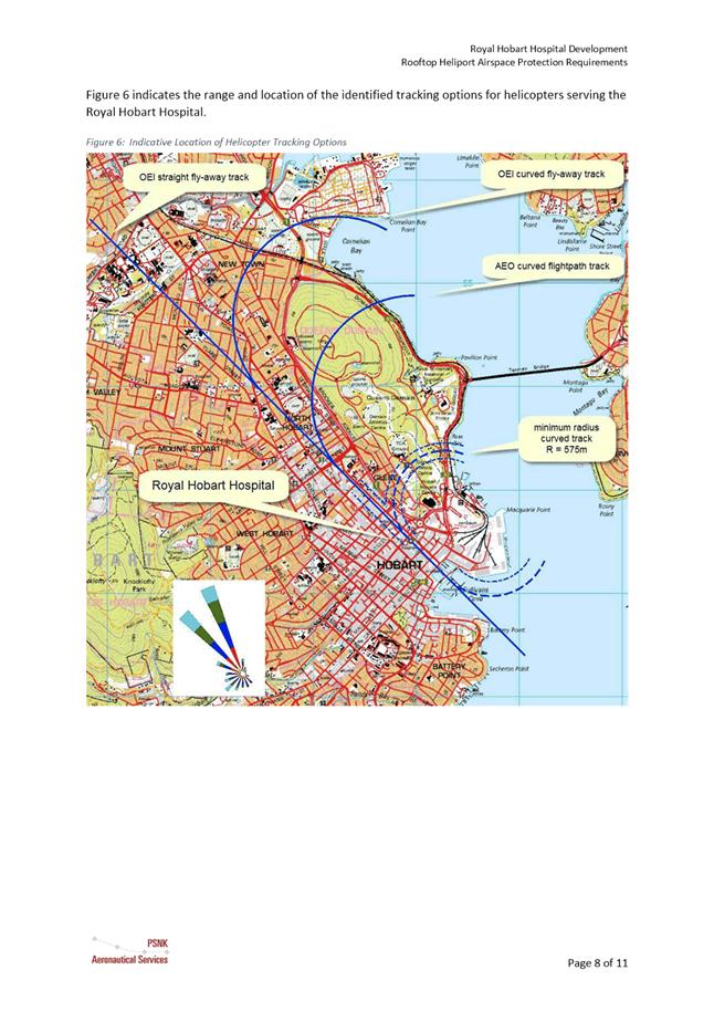
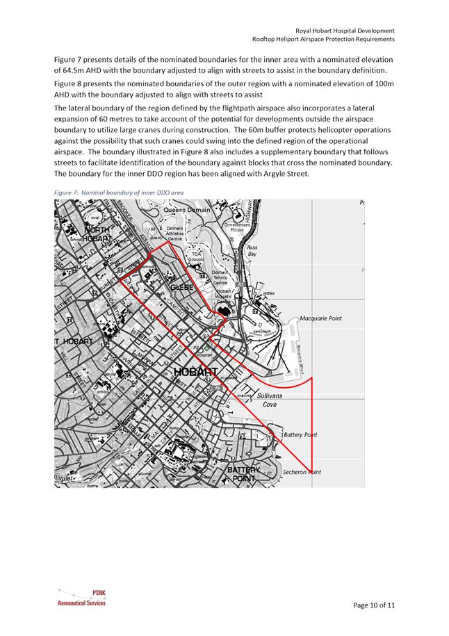
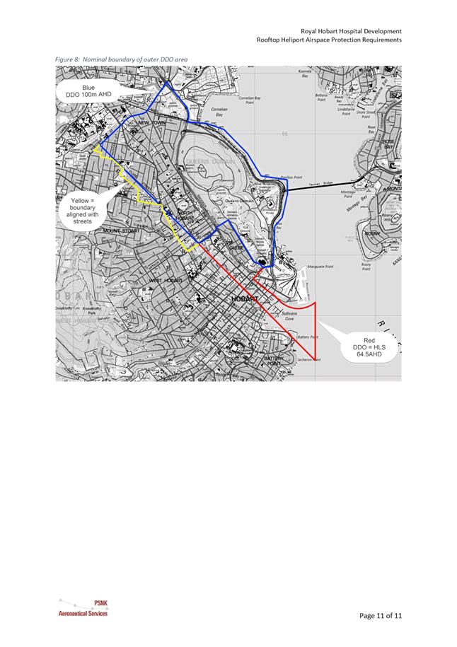
|
Agenda (Open Portion) City Planning Committee Meeting - 14/8/2017 |
Page 290 ATTACHMENT b |
|
Item No. 8.1 |
Agenda (Open Portion) City Planning Committee Meeting - 14/8/2017 |
Page 291 ATTACHMENT b |
|
Item No. 8.1 |
Agenda (Open Portion) City Planning Committee Meeting - 14/8/2017 |
Page 292 ATTACHMENT c |
|
Item No. 8.1 |
Agenda (Open Portion) City Planning Committee Meeting - 14/8/2017 |
Page 293 ATTACHMENT c |
|
Item No. 8.1 |
Agenda (Open Portion) City Planning Committee Meeting - 14/8/2017 |
Page 294 ATTACHMENT d |
|
Agenda (Open Portion) City Planning Committee Meeting - 14/8/2017 |
Page 295 ATTACHMENT e |
|
Agenda (Open Portion) City Planning Committee Meeting |
Page 296 |
|
|
|
14/8/2017 |
|
8.2 Hobart Interim Planning Scheme 2015 - Proposed Amendment - Bushfire Prone Areas Overlay - PSA-17-4
File Ref: F17/85120; PSA-17-4
Report of the Manager Planning Policy and Heritage of 9 August 2017 and attachments.
Delegation: Council
|
Item No. 8.2 |
Agenda (Open Portion) City Planning Committee Meeting |
Page 297 |
|
|
14/8/2017 |
|
REPORT TITLE: Hobart Interim Planning Scheme 2015 - Proposed Amendment - Bushfire Prone Areas Overlay - PSA-17-4
REPORT PROVIDED BY: Manager Planning Policy and Heritage
1. Report Purpose and Community Benefit
1.1. This report considers a proposal to amend the Hobart Interim Planning Scheme 2015 (HIPS2015) pursuant to Section 34 of the former provisions of the Land Use Planning and Approvals Act 1993 (LUPAA).
1.2. The proposed amendment is to insert a Bushfire-Prone Areas Overlay map as recommended by the Tasmania Fire Service (TFS). A copy of the submission from the TFS in support of the amendment is provided in Attachment A.
1.3. The purpose of this report is to consider the initiation and subsequent certification of the proposed amendment pursuant to Sections 32 and 35 of the LUPAA.
1.4. The proposal benefits the community by ensuring that greater certainty is provided in the application of the Bushfire-Prone Area Code.
2. Report Summary
2.1. This report considers a proposal to amend the HIPS2015 to insert a Bushfire-Prone Areas Overlay map as recommended by the Tasmania Fire Service (TFS). A copy of the submission from the TFS in support of the amendment is provided in Attachment A.
2.2. The TFS is working with Local Government to produce and deliver the Bushfire-Prone Area mapping for Tasmania. This mapping will ultimately form part of each Council’s planning scheme overlay map and will directly relate to the definition of ‘bushfire-prone area’ as provided in the Bushfire-Prone Areas Code.
2.3. Mapping for the City of Hobart has now been completed following collaborative work between the TFS and Council officers. This process has involved production of a modelled overlay that has been progressively refined based on site verification and knowledge of local land management practices.
2.4. The mapping will provide an authoritative and accessible information source that will simplify the assessment required to determine whether a site is located in a ‘bushfire-prone area’. This improved clarity will benefit land owners, developers and permit authorities by providing certainty with respect to planning and building regulatory controls.
2.5. It is proposed that Council initiate an amendment to the HIPS2015 to insert a Bushfire-Prone Areas Overlay map as shown in Appendix A to Attachment A.
|
That: 1. Pursuant to Section 34(1) (b) of the former provisions of the Land Use Planning and Approvals Act 1993, Council resolve to initiate an amendment to the Hobart Interim Planning Scheme 2015 by inserting a Bushfire-Prone Areas Overlay map as shown in Appendix A to Attachment A. 2. Pursuant to Section 35 of the former provisions of the Land Use Planning and Approvals Act 1993, Council certify that the amendment to the Hobart Interim Planning Scheme 2015 PSA-17-4 meets the requirements of Section 32 of the former provisions of the Land Use Planning and Approvals Act 1993 and authorise the General Manager and the Deputy General Manager to sign the Instrument of Certification (Attachment B). 3. Pursuant to Section 38 of the former provisions of the Land Use Planning and Approvals Act 1993, Council place Amendment PSA-17-4 to the Hobart Interim Planning Scheme 2015 on public exhibition for a 28 day period following certification.
|
4. Background
4.1. The Bushfire-Prone Areas Code was introduced into all Interim Planning Schemes in Tasmania by the Minister for Planning and Local Government through Planning Directive No.1.
4.2. The Bushfire-Prone Areas Code was developed collaboratively by the Director of Building Control and the TFS. Changes to the Building Regulations 2014 and the Director of Building Control’s Determination – Requirements for Building in Bushfire-Prone Areas were introduced on 17 March 2016.
4.3. These changes resulted in the Code regulating fewer matters as standards applying to development of habitable buildings in bushfire-prone areas are now implemented as part of the building regulatory framework.
4.4. The Tasmania Fire Service is working with Local Government to produce and deliver the Bushfire-Prone Area Mapping for Tasmania. This mapping will ultimately form part of each Council’s planning scheme overlay map and will directly relate to the definition of ‘bushfire-prone area’ as provided in the Bushfire-Prone Areas Code.
4.5. Mapping for the City of Hobart has now been completed following collaborative work between the Tasmania Fire Service and Council officers. This process has involved production of a modelled overlay that has been progressively refined based on site verification and knowledge of local land management practices.
4.6. The purpose of the Bushfire-Prone Areas Code (E1.0) is to ensure that use and development is appropriately designed, located, serviced, and constructed, to reduce the risk to human life and property, and the cost to the community, caused by bushfires.
4.7. The Bushfire Prone Areas Code contains use standards for vulnerable and hazardous uses in bushfire-prone areas and development standards for subdivision, including the provision of hazard management areas and access and water supply for firefighting purposes.
4.8. The Code is applied to land located within a bushfire-prone area which is defined as:
4.8.1. (a) land that is within the boundary of a bushfire-prone area shown on an overlay on a planning scheme map; or
4.8.2. (b) where there is no overlay on a planning scheme map, land that is within 100m of an area of bushfire-prone vegetation equal to or greater than 1ha.
4.9. As there is no bushfire-prone areas overlay on a planning scheme map currently in the HIPS2015 sub-clause (b) applies.
4.10. Bushfire- prone vegetation is defined as: contiguous vegetation including grasses and shrubs but not including maintained lawns, parks and gardens, nature strips, plant nurseries, golf courses, vineyards, orchards or vegetation on land that is used for horticultural purposes.
5. Proposal and Implementation
5.1. It is proposed that Council initiate an amendment to the HIPS2015 to insert a Bushfire-Prone Areas Overlay map as shown in Appendix A to Attachment B.
5.2. The mapping will provide an authoritative and accessible information source that will simplify the assessment required to determine whether a site is located in a ‘bushfire-prone area’. This improved clarity will benefit land owners, developers and permit authorities by providing certainty with respect to planning and building regulatory controls.
5.3. By removing areas from the mapping that have been deemed to be suitably low threat by the TFS, the planning scheme amendment will remove unnecessary costs and delays from the approvals process for applicants (e.g. costs of engaging a Bushfire Hazard Practitioner to certify an exemption, delays associated with s.54 requests).
5.4. The Bushfire-Prone Areas Overlay will need to be reviewed and updated periodically to ensure its accuracy as conditions evolve. This will logically form part of the review process of the Tasmanian Planning Scheme as it occurs in future years to come.
5.5. In the situation whereby land is rezoned to facilitate new development (e.g. a new greenfield estate), it may also be appropriate to review the Bushfire-Prone Areas Overlay as it applies to the subject site as part of the planning scheme amendment process.
5.6. In developing the mapping, the TFS has excluded some areas that would currently be considered as being within a ‘bushfire-prone area’ but which have been deemed to be suitably low threat. This was based on expert judgement in bushfire behaviour and supported by field inspections where required to verify conditions. By refining the application of the bushfire requirements in this way, the planning scheme amendment will facilitate fairer outcomes for landowners.
6. Strategic Planning and Policy Considerations
6.1. The proposed planning scheme amendments will assist in the achievement of the strategic objectives of the Capital City Strategic Plan 2015-2025 particularly in relation to Goal 4 Strong, Safe and Healthy Communities - 4.3 "Build community resilience, public health and safety."
7. Financial Implications
7.1. Funding Source and Impact on Current Year Operating Result
7.1.1. The planning scheme amendments do not have any financial implications.
7.2. Impact on Future Years’ Financial Result
7.2.1. None
7.3. Asset Related Implications
7.3.1. None
8. Legal, Risk and Legislative Considerations
8.1. The Land Use Planning and Approvals Act 1993 (LUPAA) requires that planning scheme amendments must seek to further the objectives of Schedule 1 of the Act and be prepared in accordance with State Policies.
8.2. The objectives of the Act require use and development to occur in a fair, orderly and sustainable manner and for the planning process to facilitate economic development in accordance with the other Schedule 1 objectives.
8.3. It is considered that the proposed amendment meets the objectives of LUPAA as outlined in section 5.1 of the TFS report (Attachment A), in particular it:
8.3.1. Assists sound strategic planning by being consistent with a state wide approach to the issue and not prejudicing the achievement the STRLUS objectives;
8.3.2. Is consistent with the objective to establish a system of planning instruments to be the principal way of setting objectives, policies and controls for the use, development and protection of land as it will support the efficient application of the Bushfire Prone Areas Code (and building regulations) by clearly identifying which land is subject to the overlay;
8.3.3. Provides greater flexibility to address changes in local environmental, social and economic circumstances in a manner that will not facilitate any loss of biodiversity or any other impacts on natural values and will improve clarity with respect to what land is considered bushfire-prone to avoid application of the planning/building regulations to land that has been deemed to be suitably low threat;
8.3.4. The mapping will support the application of planning and building requirements for bushfire protection, the key purpose of which are to reduce risk to life and property. The scheme amendment will accordingly support the aim of securing a safe environment for working, living and recreation consistent with Part 2 Objective (f).
8.4. The proposed amendment to the Planning Scheme does not introduce any new development standards, rather, it will improve the application of the Bushfire-Prone Areas Code. The amendment will accordingly not facilitate the loss of productive agricultural land, nor the degradation of coastal land or water resources. The scheme amendment is accordingly not considered to be in conflict with any of the existing State Policies. It is considered that the proposed amendment is consistent with the objectives of the State Coastal Policy due to the spatial separation from the coast in terms of both distance and development between the two.
8.5. S32(e) of the former provisions of LUPAA require that planning scheme amendments must avoid the potential for land use conflicts in adjacent planning scheme areas. The proposed amendment provides clarity in the application of the Bushfire-Prone Areas Code and does not contain any new development standards that may result in any land use conflict.
8.6. S32(f) of the former provisions of LUPAA require that planning scheme amendments must have regard to the impact that the use and development permissible under the amendment will have on the use and development of the region as an entity in environmental, economic and social terms. The proposed amendment is part of a state wide approach to the mapping of bushfire prone areas and will not result in any adverse impact on use and development in the region.
8.7. Section 30O of LUPAA requires that an amendment to an interim planning scheme is as far as practicable, consistent with the regional land use strategy. As outlined in section 5.3 of the TFS report (Attachment A) the proposed amendment is consistent with the STRLUS policy: MRH 1.4 Include provisions in planning schemes for use and development in bushfire prone areas based upon best practice bushfire risk mitigation and management.
9. Environmental Considerations
9.1. The scheme amendment is intended to clarify the application of the Bushfire-Prone Areas Code and will not facilitate any loss of biodiversity or any other impacts on natural values.
10. Community and Stakeholder Engagement
10.1. Council has requested that reports which recommend the initiation of planning scheme amendments address the need to conduct a public meeting or forum to explain the proposed amendments and also outline the explanatory information to be made available. These are addressed below:
10.1.1. It is not considered that a public forum is necessary to explain the proposed amendment to the public as it is relatively straight forward and self-explanatory.
10.1.2. The following information will be made available on the website: a copy of this report and a copy of the formal amendment document.
10.2. Council will have the opportunity to recommend to the Tasmanian Planning Commission modifications or refusal of the amendment after the 28 day public advertising period.
11. Delegation
11.1. Delegation rests with the Council.
As signatory to this report, I certify that, pursuant to Section 55(1) of the Local Government Act 1993, I hold no interest, as referred to in Section 49 of the Local Government Act 1993, in matters contained in this report.
|
James McIlhenny Manager Planning Policy and Heritage |
|
Date: 9 August 2017
File Reference: F17/85120; PSA-17-4
Attachment a: TFS
Report and Maps ⇩ ![]()
Attachment
b: Instrument
of Certification ⇩ ![]()
|
Item No. 8.2 |
Agenda (Open Portion) City Planning Committee Meeting - 14/8/2017 |
Page 304 ATTACHMENT a |
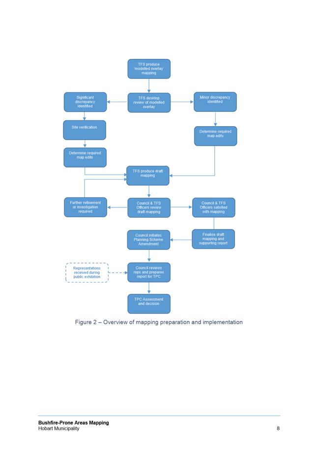
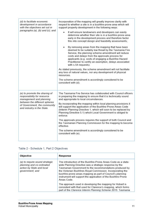
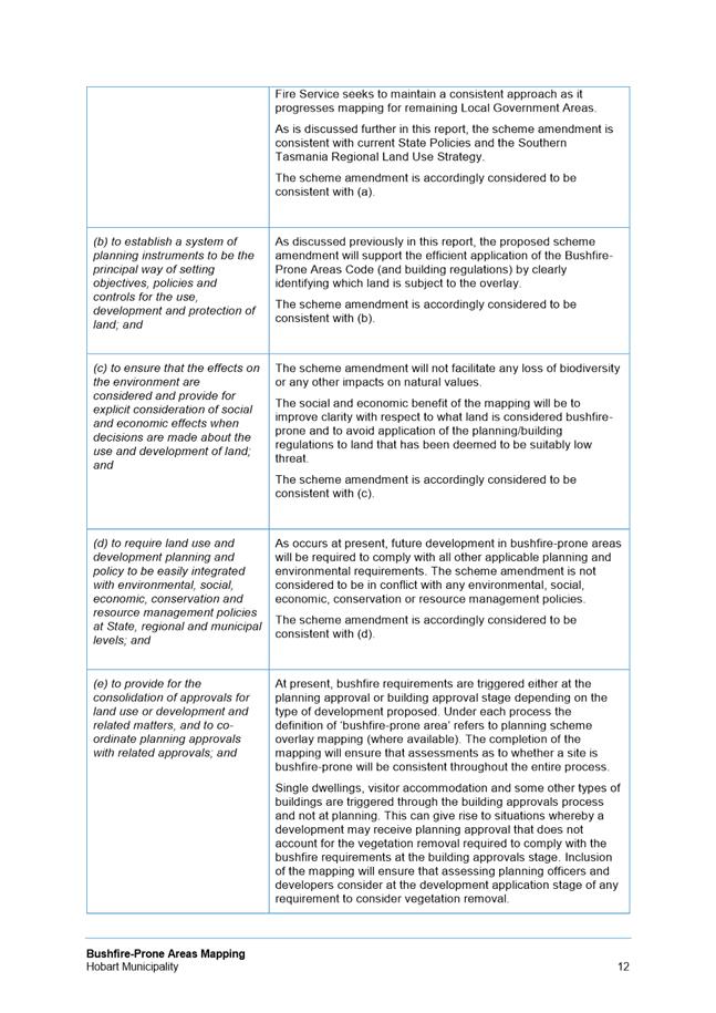
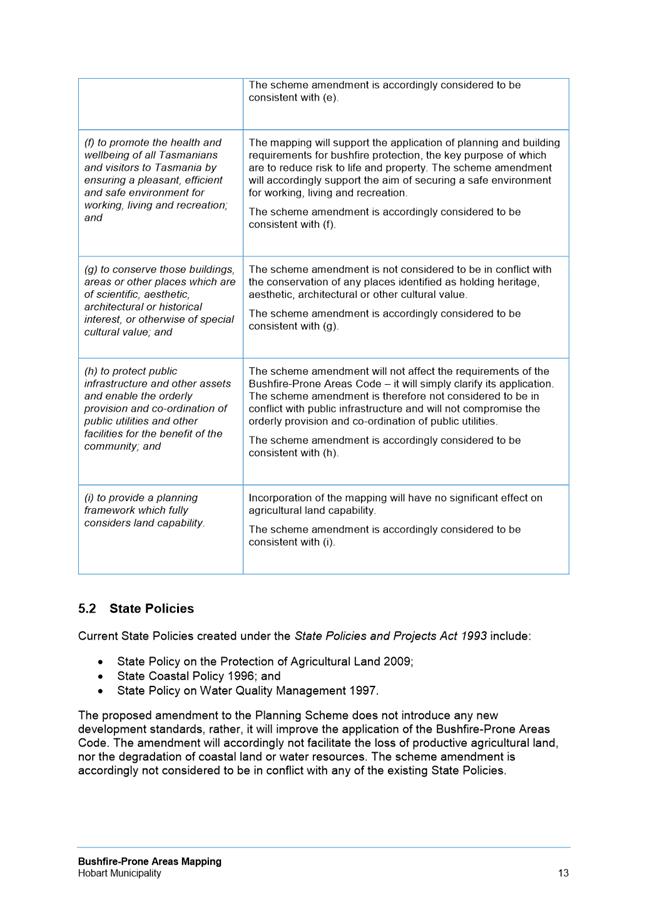
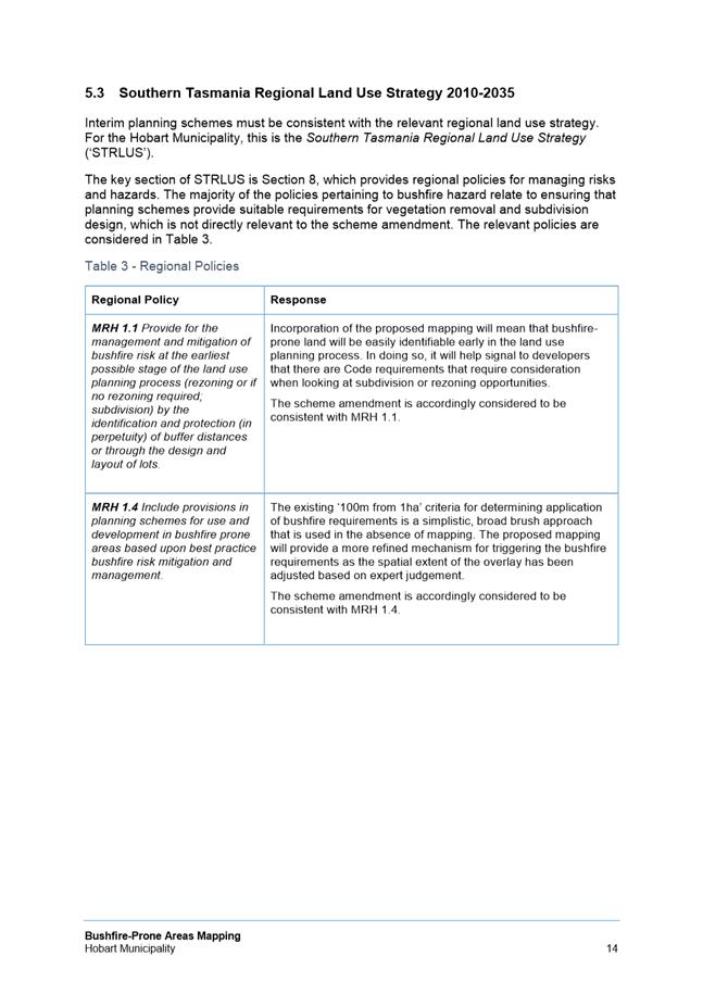
|
Item No. 8.2 |
Agenda (Open Portion) City Planning Committee Meeting - 14/8/2017 |
Page 322 ATTACHMENT a |
|
Item No. 8.2 |
Agenda (Open Portion) City Planning Committee Meeting - 14/8/2017 |
Page 323 ATTACHMENT a |
|
Item No. 8.2 |
Agenda (Open Portion) City Planning Committee Meeting - 14/8/2017 |
Page 324 ATTACHMENT a |
|
Item No. 8.2 |
Agenda (Open Portion) City Planning Committee Meeting - 14/8/2017 |
Page 325 ATTACHMENT a |
|
Item No. 8.2 |
Agenda (Open Portion) City Planning Committee Meeting - 14/8/2017 |
Page 326 ATTACHMENT a |
|
Item No. 8.2 |
Agenda (Open Portion) City Planning Committee Meeting - 14/8/2017 |
Page 327 ATTACHMENT a |
|
Item No. 8.2 |
Agenda (Open Portion) City Planning Committee Meeting - 14/8/2017 |
Page 328 ATTACHMENT a |
|
Item No. 8.2 |
Agenda (Open Portion) City Planning Committee Meeting - 14/8/2017 |
Page 330 ATTACHMENT a |
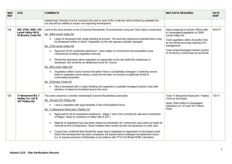
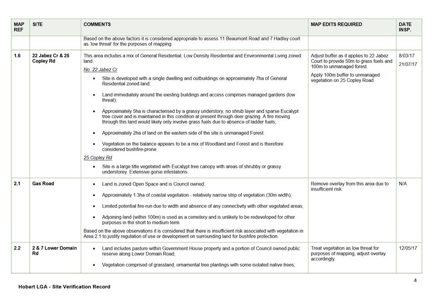
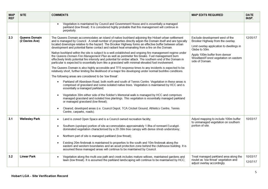
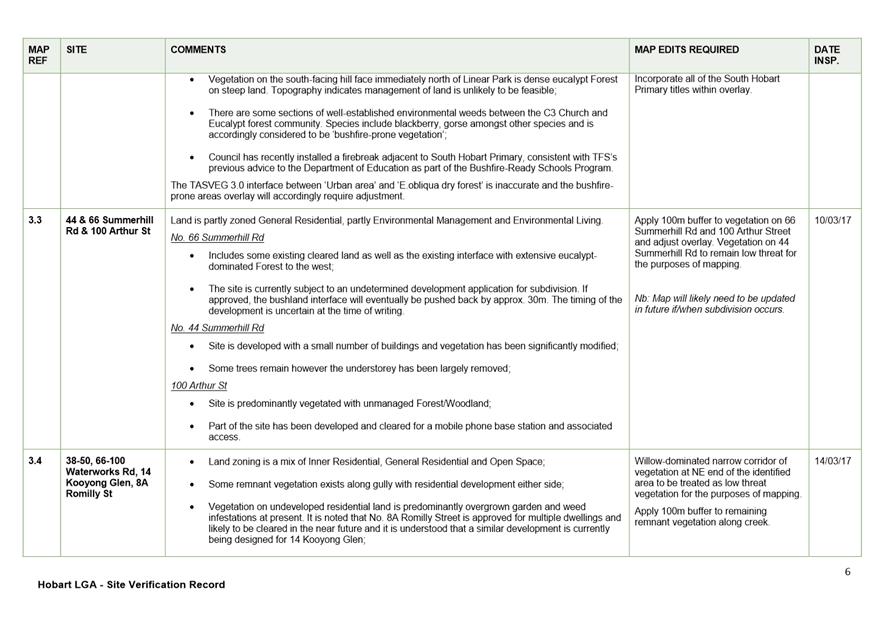
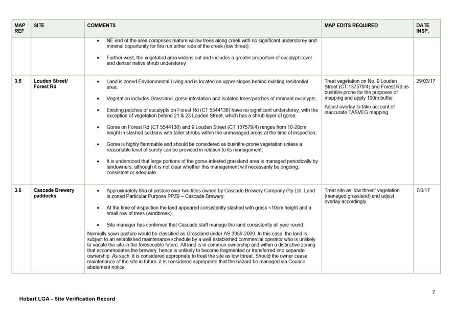
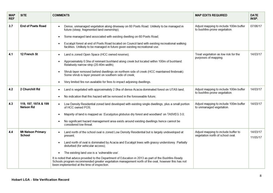
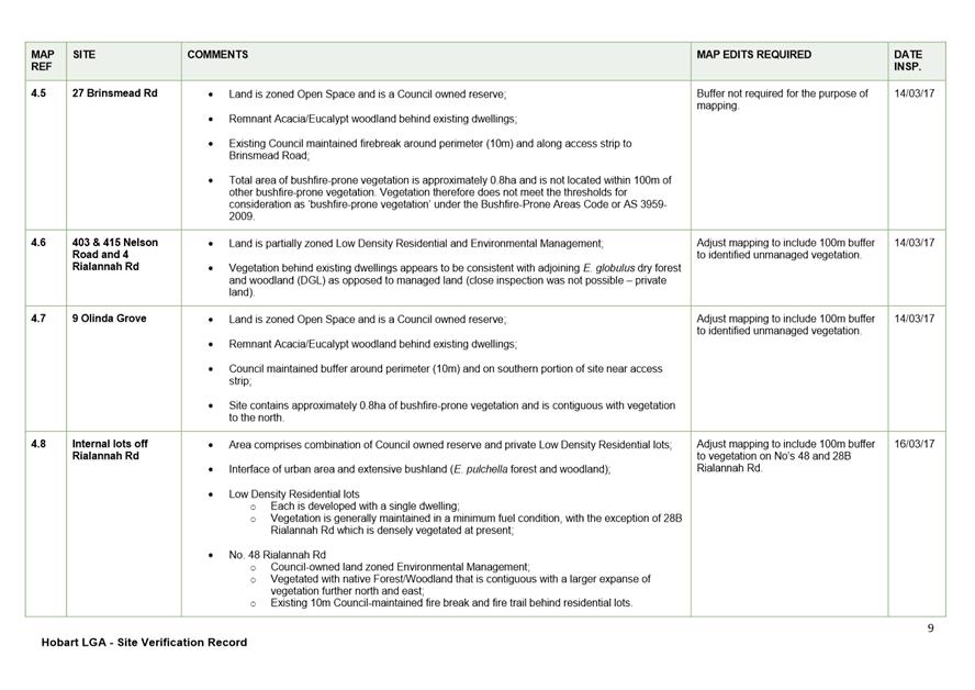
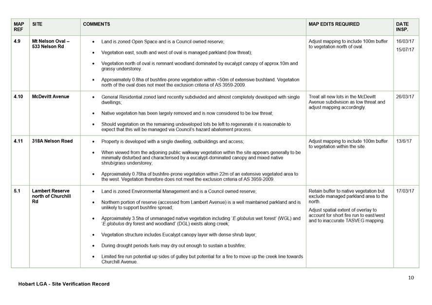
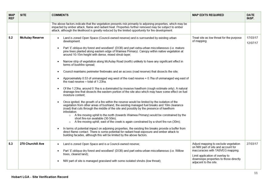
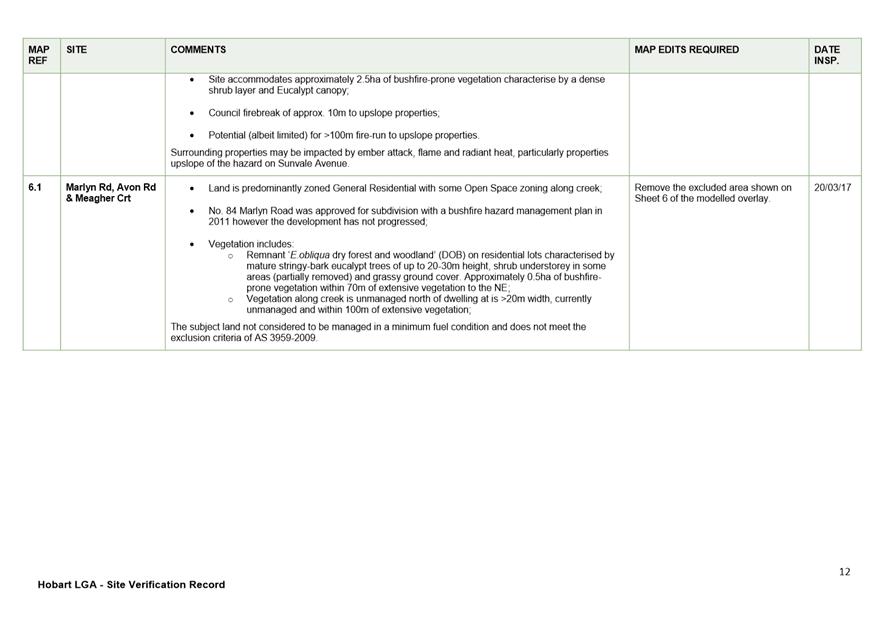
|
Item No. 8.2 |
Agenda (Open Portion) City Planning Committee Meeting - 14/8/2017 |
Page 343 ATTACHMENT a |
|
Item No. 8.2 |
Agenda (Open Portion) City Planning Committee Meeting - 14/8/2017 |
Page 344 ATTACHMENT a |
|
Item No. 8.2 |
Agenda (Open Portion) City Planning Committee Meeting - 14/8/2017 |
Page 345 ATTACHMENT a |
|
Item No. 8.2 |
Agenda (Open Portion) City Planning Committee Meeting - 14/8/2017 |
Page 346 ATTACHMENT a |
|
Item No. 8.2 |
Agenda (Open Portion) City Planning Committee Meeting - 14/8/2017 |
Page 347 ATTACHMENT a |
|
Item No. 8.2 |
Agenda (Open Portion) City Planning Committee Meeting - 14/8/2017 |
Page 348 ATTACHMENT a |
|
Item No. 8.2 |
Agenda (Open Portion) City Planning Committee Meeting - 14/8/2017 |
Page 349 ATTACHMENT a |
|
Item No. 8.2 |
Agenda (Open Portion) City Planning Committee Meeting - 14/8/2017 |
Page 350 ATTACHMENT b |
|
Agenda (Open Portion) City Planning Committee Meeting |
Page 351 |
|
|
|
14/8/2017 |
|
8.3 ETA - 17-69 - 15 Oberon Court, Dynnyrne - Subdivision (10 Lots) and Associated Hydraulic Infrastructure (Re-Advertised - Amended Proposal)
File Ref: F17/97105
Memorandum of the Acting Manager Development Appraisal and the Development Appraisal Planner City Planning of 28 July 2017 and attachment.
Delegation: Council
|
Item No. 8.3 |
Agenda (Open Portion) City Planning Committee Meeting |
Page 352 |
|
|
14/8/2017 |
|

Memorandum: City Planning Committee
ETA - 17-69 - 15 Oberon Court, Dynnyrne - Subdivision (10 Lots) and Associated Hydraulic Infrastructure (Re-Advertised - Amended Proposal)
Introduction
This memorandum relates to a request to extend the time in which to substantially commence planning permit PLN140006601 for Subdivision (10 Lots) and Associated Hydraulic Infrastructure at 15 Oberon Court, Dynnyrne. The request was made on 17 May 2017.
Background
On 27 January 2015, planning approval was granted by the full Council for Subdivision (10 Lots) and Associated Hydraulic Infrastructure at 15 Oberon Court, Dynnyrne.
The development was assessed under the City of Hobart Planning Scheme 1982.
There were two discretions:
1. Schedule K, Clause AS1.3 Residential density: Whereby four of the ten proposed lots had frontages narrower than 25m and four of the proposed lots were unable to meet the minimum inscribed circle standards.
2. Schedule I, Clause 1.2 Land clearance/disturbance: The proposal included disturbance of approximately 9000m2 of land where the permitted standard allows clearing of 500m2 within two consecutive years.
One representation was received within the statutory advertising period with concerns about the increase in traffic in the nearby road network, disturbance from the works associated with the subdivision and lack of notification of nonadjoining lots. No appeal was lodged with the Resource Management and Planning Appeal Tribunal, and as such, the date the planning permit commenced was the date of approval 27 January 2015.
A minor amendment to the planning permit was approved by the Council under delegation on 29 February 2016. The amendment allowed for realignment of lot boundaries and changes to building areas within the lots with no change to the number of lots.
The applicant has two years from the date of the permit to substantially commence the development, which is 27 January 2017, and six additional months until 27 July 2017 to request a two year extension of time. There has been no work undertaken to date.
The applicant has requested a two year extension of time (until 27 January 2019) within which to substantially commence the work. The request is made under Section 53(5)(b) of the Land Use Planning and Approvals Act 1993. The request was made on 17 May 2017, which is within the six additional month period allowed for under this provision.
The applicant has provided a letter in support of their request. It is provided at Attachment A to this memorandum.
Evaluation
Extension of time delegation
Normally, requests for an extension of time to substantially commence a permit are determined at officer level under delegation. However, that officer delegation can only be exercised when the 'strategic intent of the relevant planning scheme has not significantly changed.
The applicant lodged the development application on 23 January 2014, at which time the City of Hobart Planning Scheme 1982 was in force. However, on 20 May 2015, that changed with the Hobart Interim Planning Scheme 2015 coming into force.
If the provisions of the Hobart Interim Planning Scheme 2015 represent a significant change in the strategic intent to the provisions of the City of Hobart Planning Scheme 1982 so far as they are applicable to the development, delegation to determine the request to extend the time of the permit rests with the Council.
The strategic intent of the planning scheme
When the proposal was assessed under the City of Hobart Planning Scheme 1982, the property was located within the Residential 2 Zone, and residential density and land clearance were the only discretions.
The property is now located within the Rural Living Zone under the Hobart Interim Planning Scheme 2015.
The development standards for subdivision in the Rural Living Zone include a minimum lot size of 1ha and a minimum permitted frontage of 40m. In regards to frontage, the majority of lots would not comply with the permitted standard, however there is discretion to approve a frontage of down to 6m for a normal lot and 3.6m for an internal lot.
The change to the permitted lot size is more problematic, with the minimum lot size increasing from 750m2 under the previous planning scheme to 1ha (10,000m2) under the current planning scheme. Furthermore, there is no discretion to approve a smaller lot. That is, lots less than 1ha cannot be approved under the current planning scheme.
15 Oberon Court has an area of approximately 3.1ha. Therefore the maximum number of lots that could be approved on the site is three. As such, an application for a ten lot subdivision on this site could not be approved under the provisions of the current planning scheme. It is noted that if the extension were to be granted by the Council, and the lots created, the current planning scheme provisions restrict future residential development to single dwellings only. This is because multiple dwellings and other residential uses are prohibited in the Rural Living Zone.
Under the previous City of Hobart Planning Scheme 1982, bushfire and landslide issues were dealt with under Principle 22, Site Suitability. In the current Hobart Interim Planning Scheme 2015, these issues have been formalised into codes. When assessed originally, vegetation removal was assessed under Schedule I Clearing of Land of the City of Hobart Planning Scheme 1982. Under that planning scheme, it was permitted to clear up to 500m2 within two consecutive years, with a discretion to approve larger areas subject to assessment against the relevant criteria. Under the current Hobart Interim Planning Scheme 2015, the site is subject to the Biodiversity Code under clause E10.0, which includes specific standards relating to subdivision. The Council's Environmental Development Planner has reconsidered the proposal against the provisions of the Hobart Interim Planning Scheme 2015. The officer is of the view that if the proposal was lodged as a development application and assessed against the provisions of the Biodiversity Code of the current planning scheme, it would be recommended for approval.
The change in zone and land clearing requirements are considered to be significant changes to the strategic intent of the planning scheme provisions applicable to the site. Therefore, delegation to determine the request for an extension of time to substantially commence the permit rests with the Council.
Conclusion
The strategic intent of the Hobart Interim Planning Scheme 2015 has significantly changed in respect of 15 Oberon Court, as the site is now within the Rural Living Zone and the Biodiversity Code applies. Therefore delegation to determine the request to extend the time in which to substantially commence the permit rests with the Council.
As a consequence of the change in strategic intent of the planning scheme provisions applicable to the site, if the proposal for a ten lot subdivision at 15 Oberon Court was submitted under the current planning scheme, it could not be approved because lots cannot meet the absolute minimum lot size of 1ha (10,000m2). The current planning scheme would only allow a subdivision of a maximum of three lots on this site.
On that basis it is recommended that the Council does not grant the request for an extension of time in which to substantially commence the planning permit.
If the Council refuses to grant the extension of time request, the permit will lapse and cannot be acted on. There is no provision under the Land Use Planning and Approvals Act 1993 to appeal an extension of time refusal. However, the applicant can lodge a new development application to be assessed under the current Hobart Interim Planning Scheme 2015.
If the Council grants the request for an extension of time to the planning permit, the applicant will have until 27 January 2019 to substantially commence the work.

(Michaela Nolan)
DEVELOPMENT APPRAISAL PLANNER CITY PLANNING
|
That the Council refuse to grant the extension of time in which to substantially commence planning permit PLN140006601.
|
As signatory to this report, I certify that, pursuant to Section 55(1) of the Local Government Act 1993, I hold no interest, as referred to in Section 49 of the Local Government Act 1993, in matters contained in this report.
|
Ben Ikin Acting Manager Development Appraisal |
|
Date: 28 July 2017
File Reference: F17/97105
Attachment a: ETA-17-69
- 15 OBERON COURT DYNNYRNE TAS 7005 - Attachment A - Supporting Letter ⇩ ![]()
|
Item No. 8.3 |
Agenda (Open Portion) City Planning Committee Meeting - 14/8/2017 |
Page 357 ATTACHMENT a |
|
Agenda (Open Portion) City Planning Committee Meeting |
Page 360 |
|
|
|
14/8/2017 |
|
8.4 Visitor Accommodation Mapping
File Ref: F17/96531; 16/117
Memorandum of the Manager Planning Policy and Heritage of 9 August 2017 and attachment.
Delegation: Committee
|
Item No. 8.4 |
Agenda (Open Portion) City Planning Committee Meeting |
Page 361 |
|
|
14/8/2017 |
|
Memorandum: City Planning Committee
Visitor Accommodation Mapping
At its meeting on 19 June 2017, the Council considered a report in relation to the Interim Planning Directive regarding self-contained visitor accommodation.
The Council requested that a map be prepared showing the location of approvals of self-contained visitor accommodation over the past few years.
The attached map shows the location of self-contained visitor accommodation approvals by suburb for the past 5 years. The map illustrates that the biggest concentration of visitor accommodation approvals has been in the inner suburbs surrounding CBD and North Hobart.
|
That the information be received and noted.
|
As signatory to this report, I certify that, pursuant to Section 55(1) of the Local Government Act 1993, I hold no interest, as referred to in Section 49 of the Local Government Act 1993, in matters contained in this report.
|
James McIlhenny Manager Planning Policy and Heritage |
|
Date: 9 August 2017
File Reference: F17/96531; 16/117
Attachment a: Visitor
Accommodation Map ⇩ ![]()
|
Item No. 8.4 |
Agenda (Open Portion) City Planning Committee Meeting - 14/8/2017 |
Page 362 ATTACHMENT a |
|
Agenda (Open Portion) City Planning Committee Meeting |
Page 363 |
|
|
|
14/8/2017 |
|
8.5 Delegated Decisions Report (Planning)
File Ref: F17/96850
Memorandum of the Director City Planning of 9 August 2017 and attachment.
Delegation: Committee
|
Item No. 8.5 |
Agenda (Open Portion) City Planning Committee Meeting |
Page 364 |
|
|
14/8/2017 |
|
Memorandum: City Planning Committee
Delegated Decisions Report (Planning)
Attached is the delegated decisions report for the period 25 July 2017 until 7 August 2017.
|
That the information be received and noted.
|
As signatory to this report, I certify that, pursuant to Section 55(1) of the Local Government Act 1993, I hold no interest, as referred to in Section 49 of the Local Government Act 1993, in matters contained in this report.
|
Neil Noye Director City Planning |
|
Date: 9 August 2017
File Reference: F17/96850
Attachment a: Delegated
Decisions Report (Planning) ⇩ ![]()
|
Item No. 8.5 |
Agenda (Open Portion) City Planning Committee Meeting - 14/8/2017 |
Page 365 ATTACHMENT a |
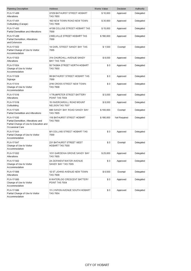
|
Agenda (Open Portion) City Planning Committee Meeting |
Page 367 |
|
|
|
14/8/2017 |
|
8.6 City Planning - Advertising List
File Ref: F17/96853
Memorandum of the Director City Planning of 9 August 2017 and attachment.
Delegation: Committee
|
Item No. 8.6 |
Agenda (Open Portion) City Planning Committee Meeting |
Page 368 |
|
|
14/8/2017 |
|
Memorandum: City Planning Committee
City Planning - Advertising List
Attached is the advertising list for the period 22 July 2017 until 4 August 2017.
|
That the information be received and noted.
|
As signatory to this report, I certify that, pursuant to Section 55(1) of the Local Government Act 1993, I hold no interest, as referred to in Section 49 of the Local Government Act 1993, in matters contained in this report.
|
Neil Noye Director City Planning |
|
Date: 9 August 2017
File Reference: F17/96853
Attachment a: City
Planning - Advertising List ⇩ ![]()
|
Item No. 8.6 |
Agenda (Open Portion) City Planning Committee Meeting - 14/8/2017 |
Page 369 ATTACHMENT a |
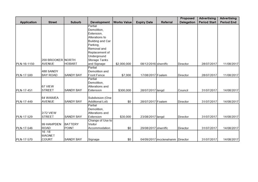
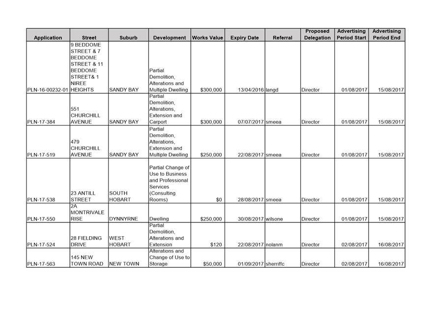
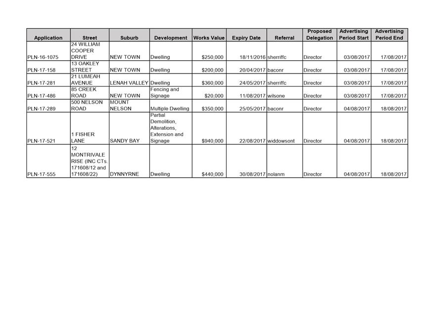
|
Agenda (Open Portion) City Planning Committee Meeting |
Page 374 |
|
|
|
14/8/2017 |
|
9 Committee Action Status Report
A report indicating the status of current decisions is attached for the information of Aldermen.
REcommendation
That the information be received and noted.
Delegation: Committee
Attachment a: City Planning Committee Status Report - July 2017
|
Item No. 9.1 |
Agenda (Open Portion) City Planning Committee Meeting - 14/8/2017 |
Page 375 ATTACHMENT a |
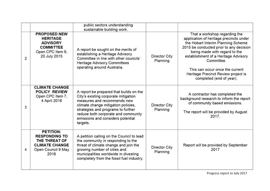
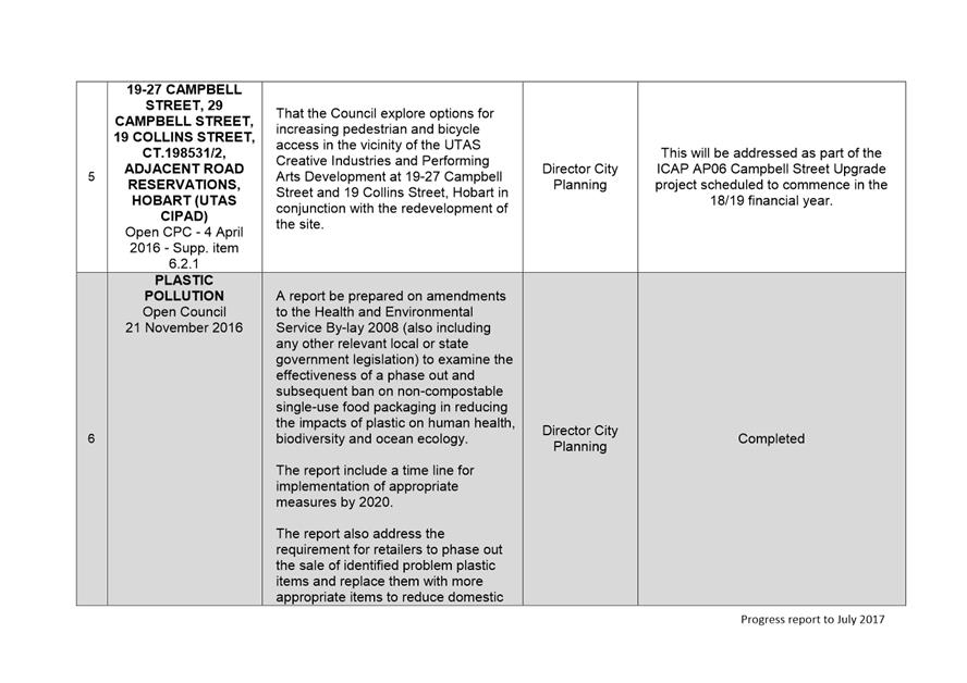
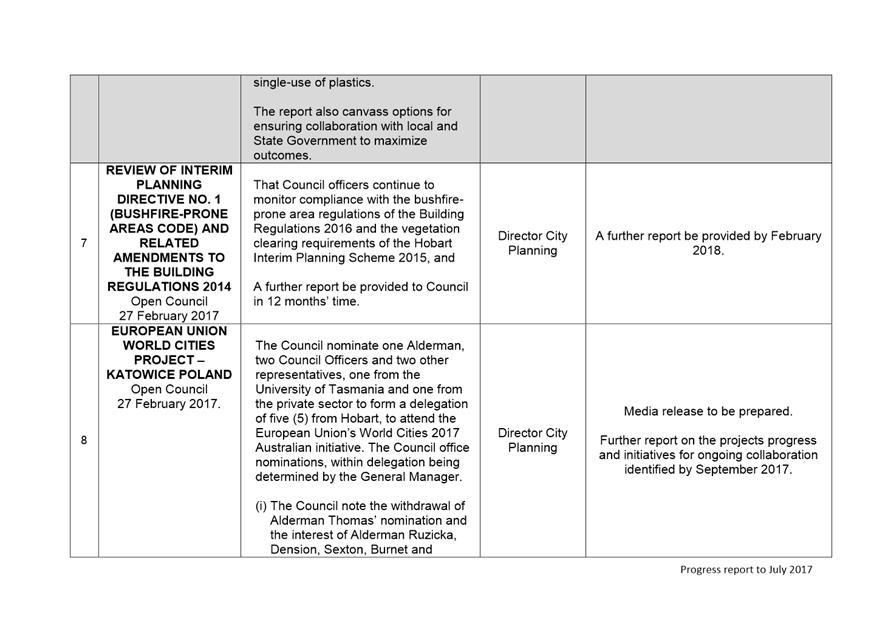
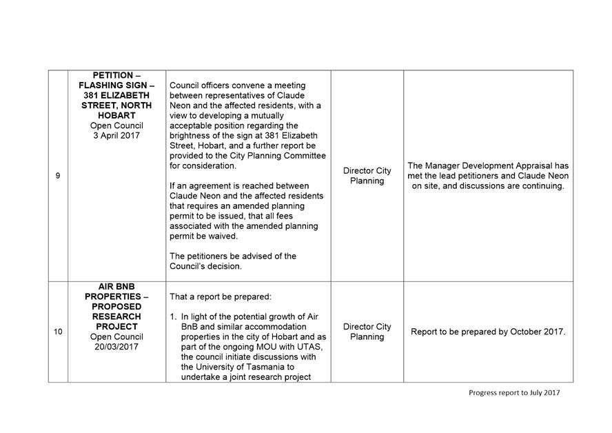
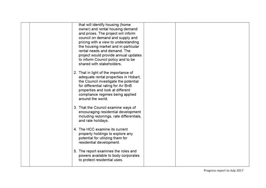
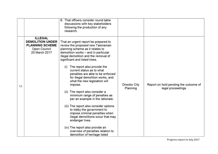
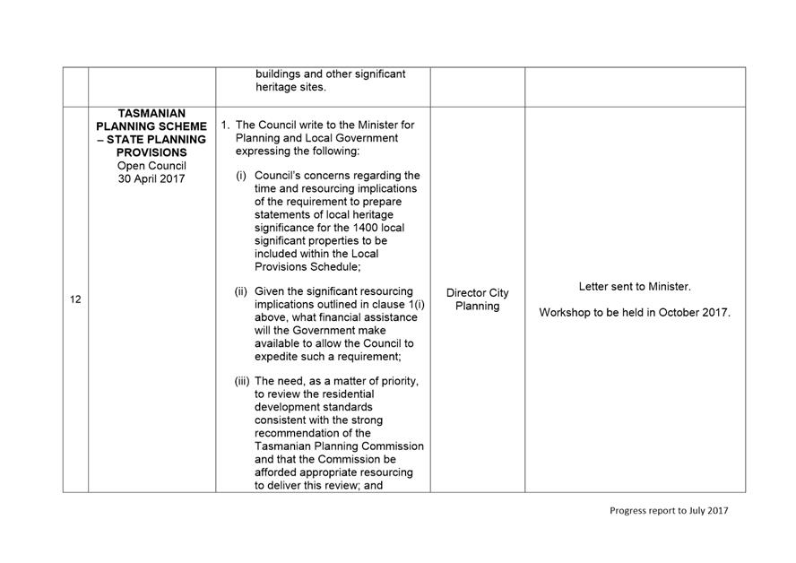
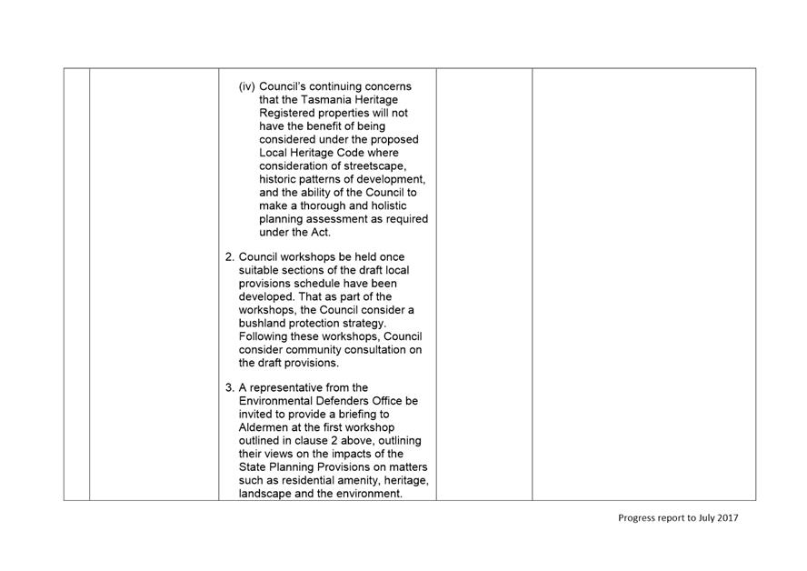
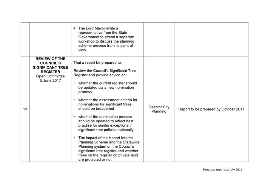
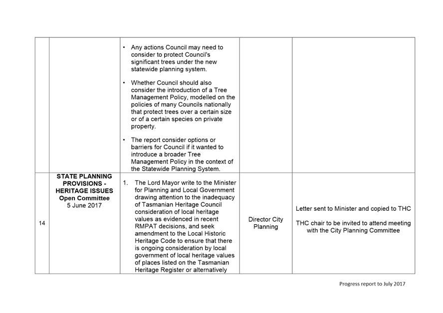

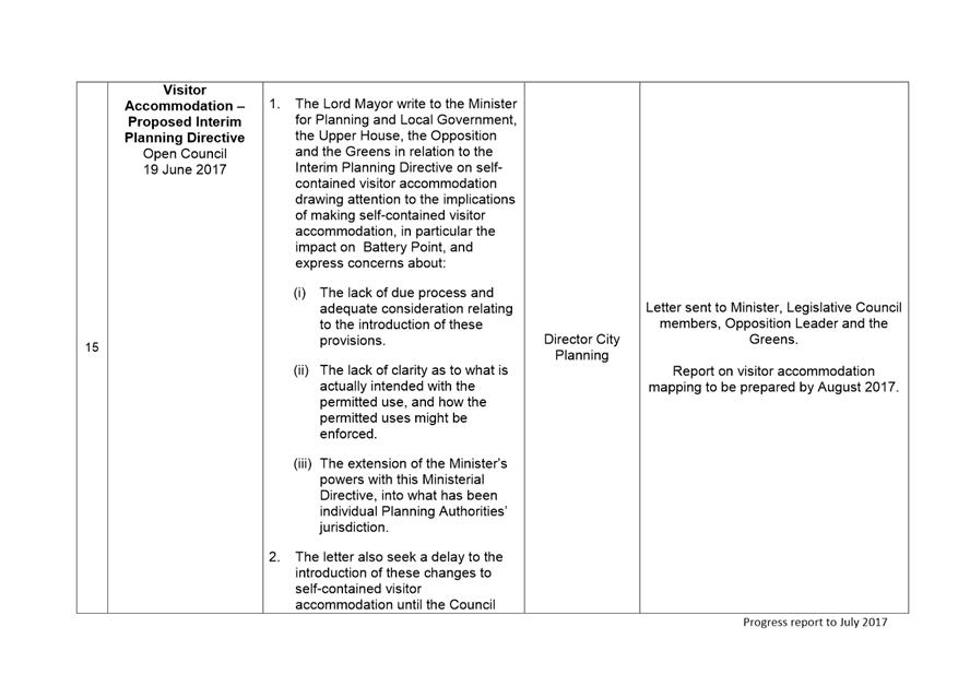
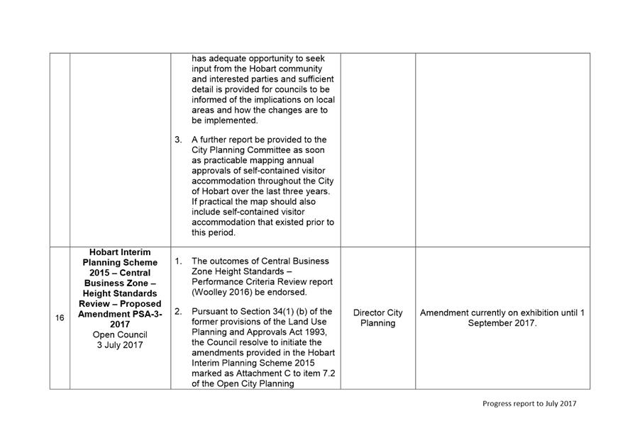
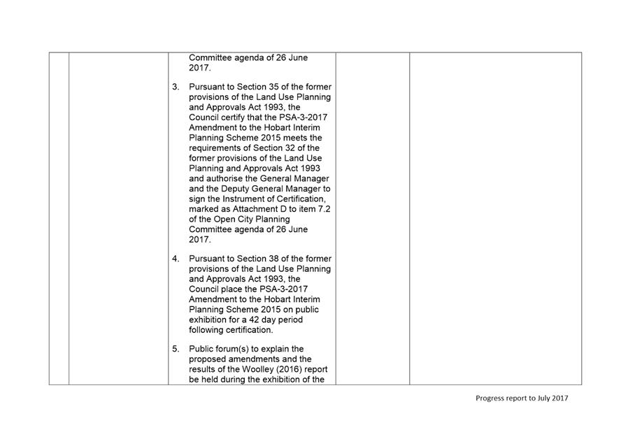
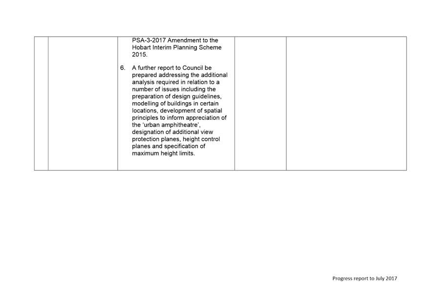
|
Agenda (Open Portion) City Planning Committee Meeting |
Page 392 |
|
|
|
14/8/2017 |
|
Regulation 29(3) Local Government
(Meeting Procedures) Regulations 2015.
File Ref: 13-1-10
The General Manager reports:-
“In accordance with the procedures approved in respect to Questions Without Notice, the following responses to questions taken on notice are provided to the Committee for information.
The Committee is reminded that in accordance with Regulation 29(3) of the Local Government (Meeting Procedures) Regulations 2015, the Chairman is not to allow discussion or debate on either the question or the response.”
10.1 Interim Planning Scheme and Precinct 33
File Ref: F17/92954; 13-1-10
Memorandum of the Director City Planning of 9 August 2017.
10.2 Construction Management Plans
File Ref: F17/51696; 13-1-10
Memorandum of the Director City Planning of 9 August 2017.
10.3 "Gattonside" 51 Sandy Bay Road, Battery Point
File Ref: F17/60667; 13-1-10
Memorandum of the Director City Planning of 9 August 2017.
10.4 Interim Planning Scheme and the Original Intent of Precinct 33
File Ref: F17/92925; 13-1-10
Memorandum of the Director City Planning of 9 August 2017.
10.5 New Builds and Precinct 33
File Ref: F17/92929; 13-1-10
Memorandum of the Director City Planning of 9 August 2017.
10.6 Planning Scheme Amendment and Precinct 33
File Ref: F17/92938; 13-1-10
Memorandum of the Director City Planning of 9 August 2017.
10.7 Local Area Provisions and the Tasmanian Planning Scheme
File Ref: F17/92941; 13-1-10
Memorandum of the Director City Planning of 9 August 2017.
10.8 Significant Trees Within Precinct 33
File Ref: F17/92948; 13-1-10
Memorandum of the Director City Planning of 9 August 2017.
10.9 Development Potential Within Precinct 33
File Ref: F17/92955; 13-1-10
Memorandum of the Director City Planning of 9 August 2017.
Delegation: Committee
|
That the information be received and noted.
|
|
Item No. 10.1 |
Agenda (Open Portion) City Planning Committee Meeting |
Page 394 |
|
|
14/8/2017 |
|
Memorandum: Lord Mayor
Deputy Lord Mayor
Aldermen
Response to Question Without Notice
Interim Planning Scheme and Precinct 33
|
Meeting: City Planning Committee
|
Meeting date: 17 July 2017
|
|
Raised by: Alderman Ruzicka |
|
Question:
Could the Director please advise as to what guidelines were not carried over into the Interim Planning Scheme for Precinct 33 and what has been lost in assessing any
application as a consequence?
Response:
It is proposed that a report be prepared for Council’s consideration in relation to the Hobart Interim Planning Scheme 2015 operation in the Lower Sandy Bay escarpment area addressing the following matters:
· How the Lower Sandy Bay Escarpment provisions were translated into the Hobart Interim Planning Scheme 2015 and whether or not there was a diminution of the escarpment protection provisions;
· The need for amendments to the Hobart Interim Planning Scheme 2015 to address concerns raised by residents of the area;
· The ability of planning scheme standards to ignore the precedent set by recent developments;
· The development potential of properties with frontage to the Lower Sandy Bay escarpment;
· Vegetation management and protection;
· Local provisions to be included in the Local Provisions Schedule of the Tasmanian Planning Scheme related to protection of the escarpment and amenity.
The above question will be addressed in that report.
As signatory to this report, I certify that, pursuant to Section 55(1) of the Local Government Act 1993, I hold no interest, as referred to in Section 49 of the Local Government Act 1993, in matters contained in this report.
|
Neil Noye Director City Planning |
|
Date: 9 August 2017
File Reference: F17/92954; 13-1-10
|
Item No. 10.2 |
Agenda (Open Portion) City Planning Committee Meeting |
Page 396 |
|
|
14/8/2017 |
|
Memorandum: Lord Mayor
Deputy Lord Mayor
Aldermen
Response to Question Without Notice
Construction Management Plans
|
Meeting: City Planning Committee
|
Meeting date: 1 May 2017
|
|
Raised by: Alderman Reynolds |
|
Question:
(i) Can a memo be provided which outlines the regulatory basis for Construction Management Plans (CMPs)?
(ii) Could Hobart City Council introduce its own bylaw for CMPs that would outline when they are to be used and some of the standard provisions? Could Council take steps to standardise and promote CMP guidelines like many Councils in Victoria have done?
Response:
(i) In general terms, the ability for Council acting as planning authority to condition planning permits issued under Sections 57 and 58 of the Land Use Planning and Approvals Act 1993 arises from Sections 51(3A) and (4) of that Act which state respectively as follows:
(3A) A permit to which Section 57 applies may be subject to such conditions or restrictions as the planning authority may impose.
(4) A permit to which Section 58 applies may be granted subject to such conditions or restrictions as the planning authority may impose with respect to any matter specified in the relevant planning scheme.
Under the Sullivans Cove Planning Scheme 1997, these sections of the Act provide the regulatory basis for requiring construction management plans, noting that environmental management issues including water quality, air pollution, land contamination, waste minimisation, noise pollution and vibration are also controlled under Schedule 8 of that planning scheme.
Under the Hobart Interim Planning Scheme 2015, and in addition to Sections 51(3A) and (4) of Land Use Planning and Approvals Act 1993, Clause 8.11.3 of that states:
8.11.3 The planning authority may also impose conditions on a permit to minimise impact from construction works on the environment and infrastructure and to ensure that works will be undertaken in accordance with best practice management that limits the potential for significant impacts arising from the following:
(a) Soil loss and associated sedimentation of watercourses, wetlands and stormwater infrastructure;
(b) The spread of weeds;
(c) The spread of soil pathogens;
(d) Unsatisfactorily managed waste; and
(e) Carparking, traffic flow and circulation during construction.
(ii) While, in broad terms, a construction management plan bylaw could potentially be created under the provisions of the Local Government Act 1993, doing so is not considered necessary at this point in time. As discussed above, the head of power already exists for construction management plans to be imposed as conditions on planning permits. For developments not requiring a planning permit, matters often regulated by construction management plans, including soil and water management, noise, dust, etc are able to be regulated via the provisions of the Environmental Management and Pollution Control Act 1994 if needs be.
There are examples of Victorian Councils publishing guidelines associated with construction management plans. Some are quite detailed, and although it is difficult to provide in-depth feedback without undertaking a more rigorous review, that detail may reflect a more complex legal framework supporting that jurisdiction. While there is not considered to be a need for a construction management plan bylaw, and while there may be fewer developments within the City Of Hobart of a scale warranting construction management plans, Council could develop guidelines that detail the objectives and common components of construction management plans, and provide guidance to developers who are required to provide them.
As signatory to this report, I certify that, pursuant to Section 55(1) of the Local Government Act 1993, I hold no interest, as referred to in Section 49 of the Local Government Act 1993, in matters contained in this report.
|
Neil Noye Director City Planning |
|
Date: 9 August 2017
File Reference: F17/51696; 13-1-10
|
Item No. 10.3 |
Agenda (Open Portion) City Planning Committee Meeting |
Page 398 |
|
|
14/8/2017 |
|
Memorandum: Lord Mayor
Deputy Lord Mayor
Aldermen
Response to Question Without Notice
"Gattonside" 51 Sandy Bay Road, Battery Point
|
Meeting: City Planning Committee
|
Meeting date: 29 May 2017
|
|
Raised by: Alderman Reynolds |
|
Question:
(i) Could the Director please advise as to whether there is a construction management plan currently in place?
(ii) Have any complaints been received in relation to the current works being undertaken?
(iii) Has the tree been felled?
Response:
(i) A
construction management plan was not a condition of approval imposed by the
Resource Management and Planning Appeal Tribunal for the redevelopment of this
site.
(ii) Two
separate complaints have been received since the construction commenced on the
site earlier this year. They included a complaint concerning dust from a
neighbour which was investigated by Council officers at the time. The
building contractor was reminded of the need to supress dust and had
implemented measures to do so.
A second complaint was made relating to alleged structural damage to a
neighbouring property as a result of blasting activities on the site.
Such complaints are regulated through Part 6 of the Building Act 2016 and
is not a matter that the Council has jurisdiction over.
(iii) All trees approved within the approved landscape plan for removal have been removed.
As signatory to this report, I certify that, pursuant to Section 55(1) of the Local Government Act 1993, I hold no interest, as referred to in Section 49 of the Local Government Act 1993, in matters contained in this report.
|
Neil Noye Director City Planning |
|
Date: 9 August 2017
File Reference: F17/60667; 13-1-10
|
Item No. 10.4 |
Agenda (Open Portion) City Planning Committee Meeting |
Page 400 |
|
|
14/8/2017 |
|
Memorandum: Lord Mayor
Deputy Lord Mayor
Aldermen
Response to Question Without Notice
Interim Planning Scheme and the Original Intent of Precinct 33
|
Meeting: City Planning Committee
|
Meeting date: 17 July 2017
|
|
Raised by: Alderman Ruzicka |
|
Question:
The current Interim Scheme appears to be subverting the original intent of what Precinct 33 started out to protect. Could the Director please advise if over the years has the character of the area been changed, if not “gamed” by the performance criteria?
Response:
It is proposed that a report be prepared for Council’s consideration in relation to the Hobart Interim Planning Scheme 2015 operation in the Lower Sandy Bay escarpment area addressing the following matters:
· How the Lower Sandy Bay Escarpment provisions were translated into the Hobart Interim Planning Scheme 2015 and whether or not there was a diminution of the escarpment protection provisions;
· The need for amendments to the Hobart Interim Planning Scheme 2015 to address concerns raised by residents of the area;
· The ability of planning scheme standards to ignore the precedent set by recent developments;
· The development potential of properties with frontage to the Lower Sandy Bay escarpment;
· Vegetation management and protection;
· Local provisions to be included in the Local Provisions Schedule of the Tasmanian Planning Scheme related to protection of the escarpment and amenity.
The above question will be addressed in that report.
As signatory to this report, I certify that, pursuant to Section 55(1) of the Local Government Act 1993, I hold no interest, as referred to in Section 49 of the Local Government Act 1993, in matters contained in this report.
|
Neil Noye Director City Planning |
|
Date: 9 August 2017
File Reference: F17/92925; 13-1-10
|
Item No. 10.5 |
Agenda (Open Portion) City Planning Committee Meeting |
Page 402 |
|
|
14/8/2017 |
|
Memorandum: Lord Mayor
Deputy Lord Mayor
Aldermen
Response to Question Without Notice
New Builds and Precinct 33
|
Meeting: City Planning Committee
|
Meeting date: 17 July 2017
|
|
Raised by: Alderman Ruzicka |
|
Question:
Could the Director please advise if there is any way that any new builds cannot be used as precedents in interpreting the performance criteria and acceptable solutions within the area of Precinct 33?
Response:
It is proposed that a report be prepared for Council’s consideration in relation to the Hobart Interim Planning Scheme 2015 operation in the Lower Sandy Bay escarpment area addressing the following matters:
· How the Lower Sandy Bay Escarpment provisions were translated into the Hobart Interim Planning Scheme 2015 and whether or not there was a diminution of the escarpment protection provisions;
· The need for amendments to the Hobart Interim Planning Scheme 2015 to address concerns raised by residents of the area;
· The ability of planning scheme standards to ignore the precedent set by recent developments;
· The development potential of properties with frontage to the Lower Sandy Bay escarpment;
· Vegetation management and protection;
· Local provisions to be included in the Local Provisions Schedule of the Tasmanian Planning Scheme related to protection of the escarpment and amenity.
The above question will be addressed in that report.
As signatory to this report, I certify that, pursuant to Section 55(1) of the Local Government Act 1993, I hold no interest, as referred to in Section 49 of the Local Government Act 1993, in matters contained in this report.
|
Neil Noye Director City Planning |
|
Date: 9 August 2017
File Reference: F17/92929; 13-1-10
|
Item No. 10.6 |
Agenda (Open Portion) City Planning Committee Meeting |
Page 404 |
|
|
14/8/2017 |
|
Memorandum: Lord Mayor
Deputy Lord Mayor
Aldermen
Response to Question Without Notice
Planning Scheme Amendment and Precinct 33
|
Meeting: City Planning Committee
|
Meeting date: 17 July 2017
|
|
Raised by: Alderman Burnet |
|
Question:
Could the Director please advise if there is a possibility for the Council and not the community group Precinct 33 to lodge a suitable Planning Scheme amendment to better protect the area as per the consistent concerns raised by the Precinct 33 Group?
Response:
It is proposed that a report be prepared for Council’s consideration in relation to the Hobart Interim Planning Scheme 2015 operation in the Lower Sandy Bay escarpment area addressing the following matters:
· How the Lower Sandy Bay Escarpment provisions were translated into the Hobart Interim Planning Scheme 2015 and whether or not there was a diminution of the escarpment protection provisions;
· The need for amendments to the Hobart Interim Planning Scheme 2015 to address concerns raised by residents of the area;
· The ability of planning scheme standards to ignore the precedent set by recent developments;
· The development potential of properties with frontage to the Lower Sandy Bay escarpment;
· Vegetation management and protection;
· Local provisions to be included in the Local Provisions Schedule of the Tasmanian Planning Scheme related to protection of the escarpment and amenity.
The above question will be addressed in that report.
As signatory to this report, I certify that, pursuant to Section 55(1) of the Local Government Act 1993, I hold no interest, as referred to in Section 49 of the Local Government Act 1993, in matters contained in this report.
|
Neil Noye Director City Planning |
|
Date: 9 August 2017
File Reference: F17/92938; 13-1-10
|
Item No. 10.7 |
Agenda (Open Portion) City Planning Committee Meeting |
Page 406 |
|
|
14/8/2017 |
|
Memorandum: Lord Mayor
Deputy Lord Mayor
Aldermen
Response to Question Without Notice
Local Area Provisions and the Tasmanian Planning Scheme
|
Meeting: City Planning Committee
|
Meeting date: 17 July 2017
|
|
Raised by: Alderman Burnet |
|
Question:
In relation to the Local Area Provisions being drafted as part of the Tasmanian Planning Scheme, could the Director please advise if these will protect the concerns on density, protection and amenity, raised by the Precinct 33 group as per their amendments?
Response:
It is proposed that a report be prepared for Council’s consideration in relation to the Hobart Interim Planning Scheme 2015 operation in the Lower Sandy Bay escarpment area addressing the following matters:
· How the Lower Sandy Bay Escarpment provisions were translated into the Hobart Interim Planning Scheme 2015 and whether or not there was a diminution of the escarpment protection provisions;
· The need for amendments to the Hobart Interim Planning Scheme 2015 to address concerns raised by residents of the area;
· The ability of planning scheme standards to ignore the precedent set by recent developments;
· The development potential of properties with frontage to the Lower Sandy Bay escarpment;
· Vegetation management and protection;
· Local provisions to be included in the Local Provisions Schedule of the Tasmanian Planning Scheme related to protection of the escarpment and amenity.
The above question will be addressed in that report.
As signatory to this report, I certify that, pursuant to Section 55(1) of the Local Government Act 1993, I hold no interest, as referred to in Section 49 of the Local Government Act 1993, in matters contained in this report.
|
Neil Noye Director City Planning |
|
Date: 9 August 2017
File Reference: F17/92941; 13-1-10
|
Item No. 10.8 |
Agenda (Open Portion) City Planning Committee Meeting |
Page 408 |
|
|
14/8/2017 |
|
Memorandum: Lord Mayor
Deputy Lord Mayor
Aldermen
Response to Question Without Notice
Significant Trees Within Precinct 33
|
Meeting: City Planning Committee
|
Meeting date: 17 July 2017
|
|
Raised by: Alderman Burnet |
|
Question:
In relation to significant trees located within the Precinct 33 area, could the Director please advise as to whether these trees can be protected within this area, as has been raised in other areas as part of the character of the Precinct?
Response:
It is proposed that a report be prepared for Council’s consideration in relation to the Hobart Interim Planning Scheme 2015 operation in the Lower Sandy Bay escarpment area addressing the following matters:
· How the Lower Sandy Bay Escarpment provisions were translated into the Hobart Interim Planning Scheme 2015 and whether or not there was a diminution of the escarpment protection provisions;
· The need for amendments to the Hobart Interim Planning Scheme 2015 to address concerns raised by residents of the area;
· The ability of planning scheme standards to ignore the precedent set by recent developments;
· The development potential of properties with frontage to the Lower Sandy Bay escarpment;
· Vegetation management and protection;
· Local provisions to be included in the Local Provisions Schedule of the Tasmanian Planning Scheme related to protection of the escarpment and amenity.
The above question will be addressed in that report.
As signatory to this report, I certify that, pursuant to Section 55(1) of the Local Government Act 1993, I hold no interest, as referred to in Section 49 of the Local Government Act 1993, in matters contained in this report.
|
Neil Noye Director City Planning |
|
Date: 9 August 2017
File Reference: F17/92948; 13-1-10
|
Item No. 10.9 |
Agenda (Open Portion) City Planning Committee Meeting |
Page 410 |
|
|
14/8/2017 |
|
Memorandum: Lord Mayor
Deputy Lord Mayor
Aldermen
Response to Question Without Notice
Development Potential Within Precinct 33
|
Meeting: City Planning Committee
|
Meeting date: 17 July 2017
|
|
Raised by: Alderman Briscoe |
|
Question:
Could the Director please advise as to what development potential still exists within the area of Precinct 33?
Response:
It is proposed that a report be prepared for Council’s consideration in relation to the Hobart Interim Planning Scheme 2015 operation in the Lower Sandy Bay escarpment area addressing the following matters:
· How the Lower Sandy Bay Escarpment provisions were translated into the Hobart Interim Planning Scheme 2015 and whether or not there was a diminution of the escarpment protection provisions;
· The need for amendments to the Hobart Interim Planning Scheme 2015 to address concerns raised by residents of the area;
· The ability of planning scheme standards to ignore the precedent set by recent developments;
· The development potential of properties with frontage to the Lower Sandy Bay escarpment;
· Vegetation management and protection;
· Local provisions to be included in the Local Provisions Schedule of the Tasmanian Planning Scheme related to protection of the escarpment and amenity.
The above question will be addressed in that report.
As signatory to this report, I certify that, pursuant to Section 55(1) of the Local Government Act 1993, I hold no interest, as referred to in Section 49 of the Local Government Act 1993, in matters contained in this report.
|
Neil Noye Director City Planning |
|
Date: 9 August 2017
File Reference: F17/92955; 13-1-10
|
|
Agenda (Open Portion) City Planning Committee Meeting |
Page 412 |
|
|
14/8/2017 |
|
Section 29 of the Local Government (Meeting Procedures) Regulations 2015.
File Ref: 13-1-10
An Alderman may ask a question without notice of the Chairman, another Alderman, the General Manager or the General Manager’s representative, in line with the following procedures:
1. The Chairman will refuse to accept a question without notice if it does not relate to the Terms of Reference of the Council committee at which it is asked.
2. In putting a question without notice, an Alderman must not:
(i) offer an argument or opinion; or
(ii) draw any inferences or make any imputations – except so far as may be necessary to explain the question.
3. The Chairman must not permit any debate of a question without notice or its answer.
4. The Chairman, Aldermen, General Manager or General Manager’s representative who is asked a question may decline to answer the question, if in the opinion of the respondent it is considered inappropriate due to its being unclear, insulting or improper.
5. The Chairman may require a question to be put in writing.
6. Where a question without notice is asked and answered at a meeting, both the question and the response will be recorded in the minutes of that meeting.
7. Where a response is not able to be provided at the meeting, the question will be taken on notice and
(i) the minutes of the meeting at which the question is asked will record the question and the fact that it has been taken on notice.
(ii) a written response will be provided to all Aldermen, at the appropriate time.
(iii) upon the answer to the question being circulated to Aldermen, both the question and the answer will be listed on the agenda for the next available ordinary meeting of the committee at which it was asked, where it will be listed for noting purposes only.
|
|
Agenda (Open Portion) City Planning Committee Meeting |
Page 413 |
|
|
14/8/2017 |
|