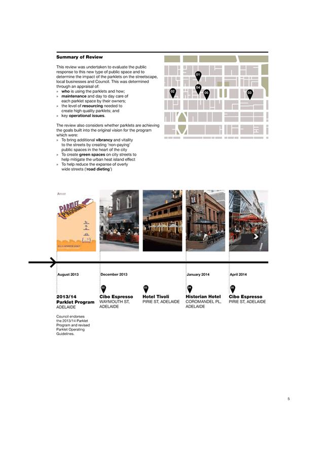
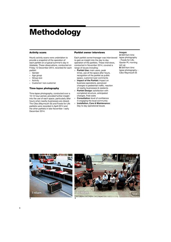
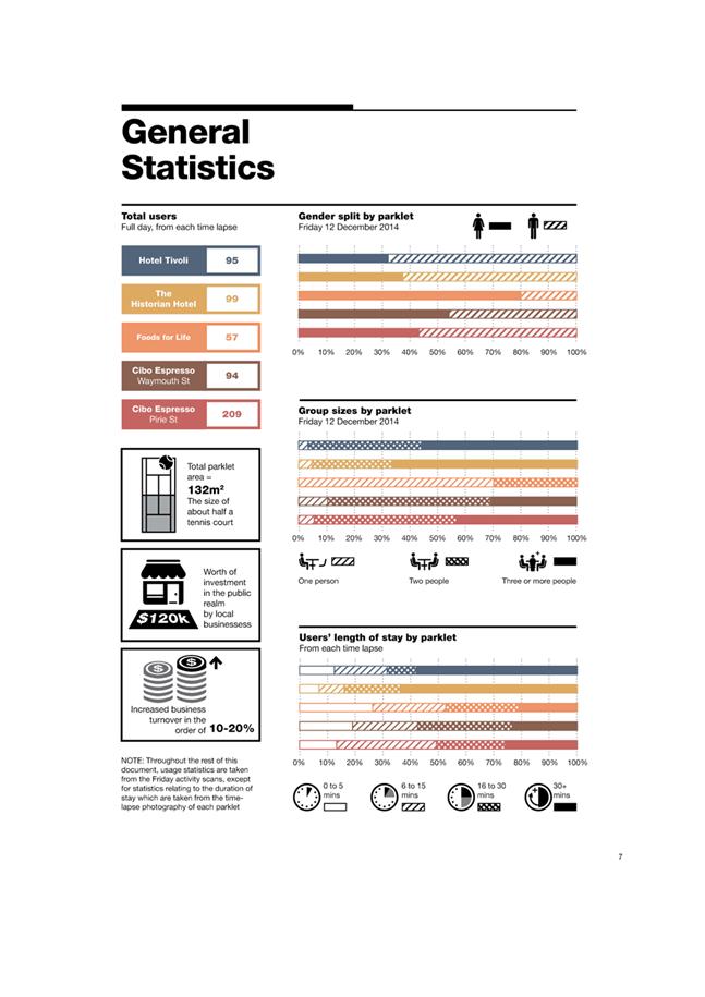
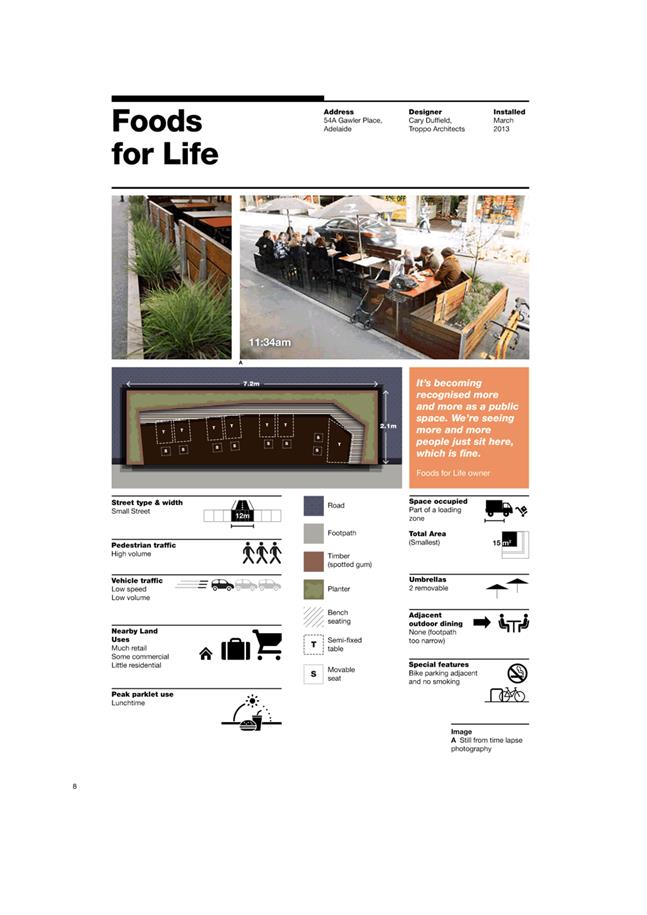
City
of hobart
AGENDA
City Infrastructure Committee Meeting
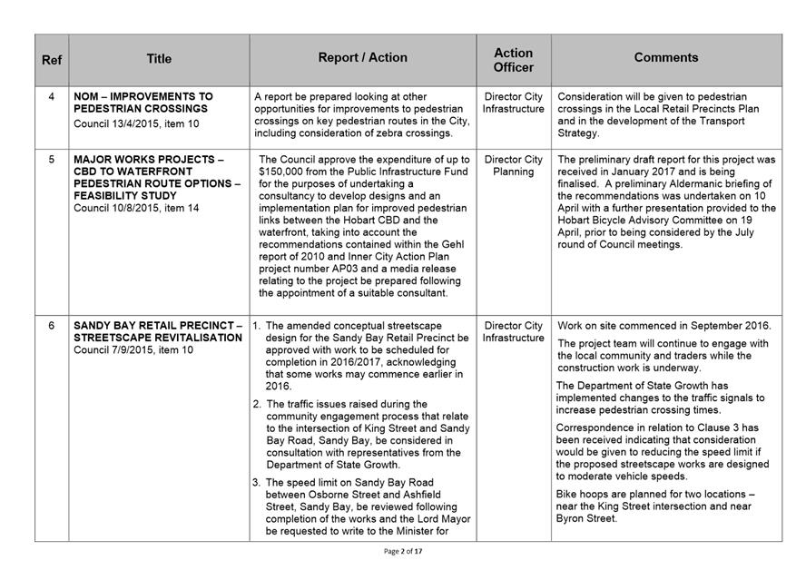
Open Portion
Wednesday, 21 June 2017
at 5.00 pm
Lady Osborne Room, Town Hall
City
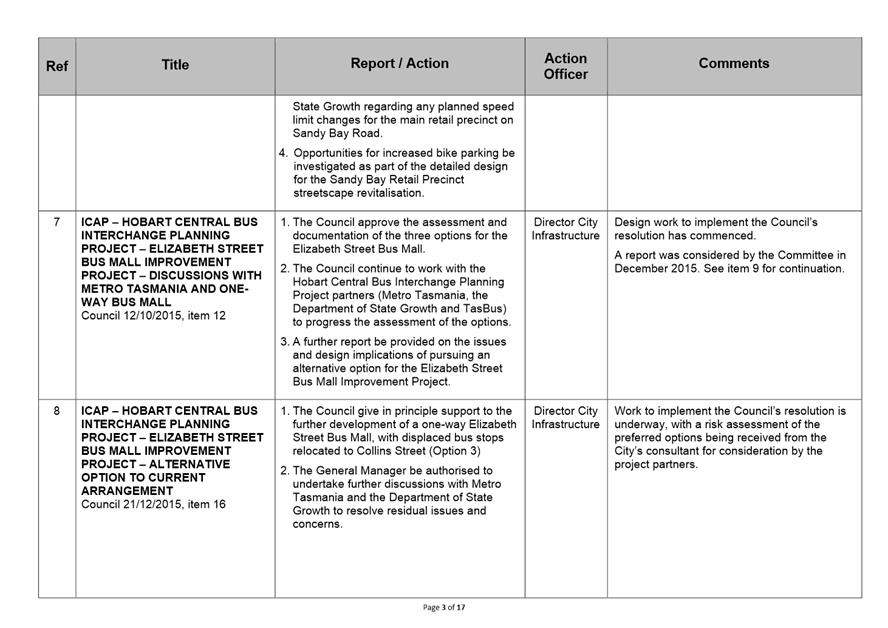
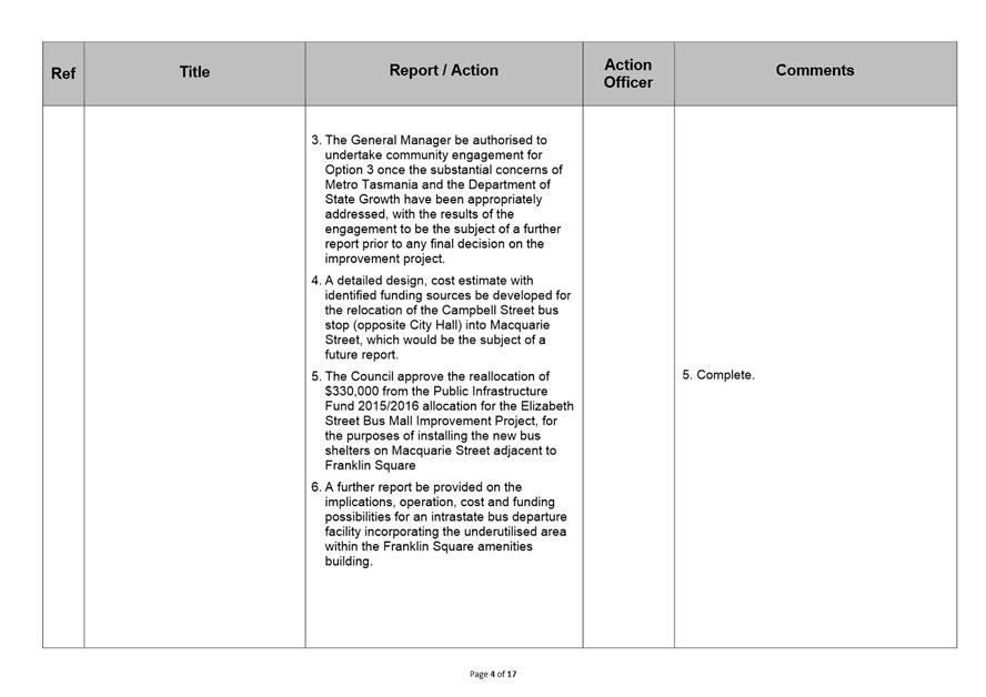
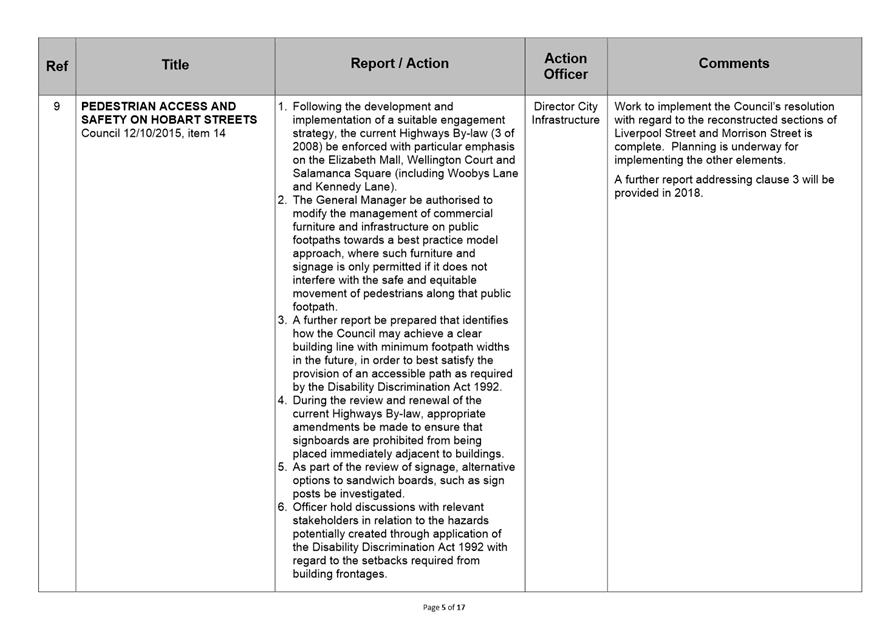
of hobart
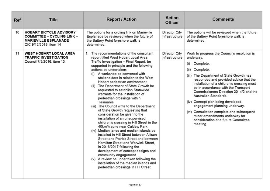
AGENDA
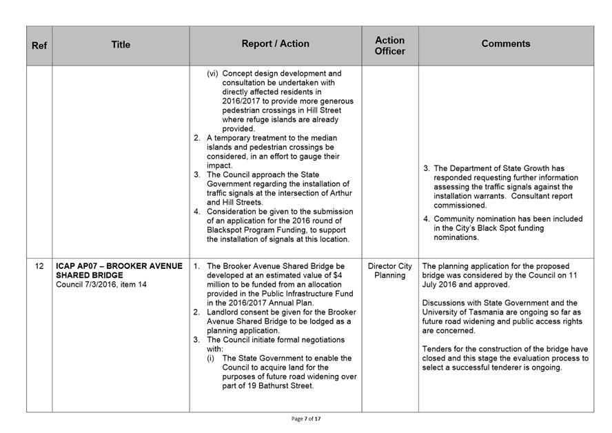
City Infrastructure Committee Meeting
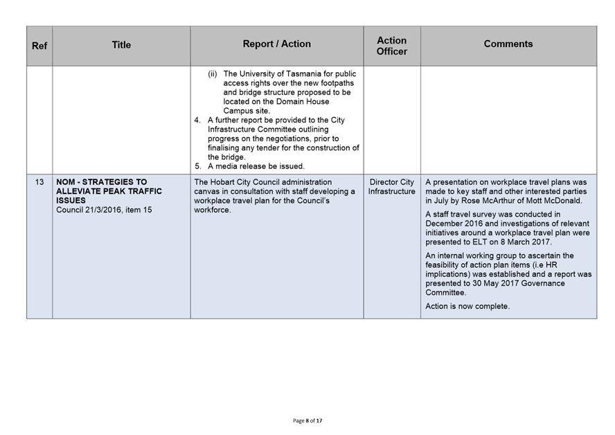
Open Portion
Wednesday, 21 June 2017
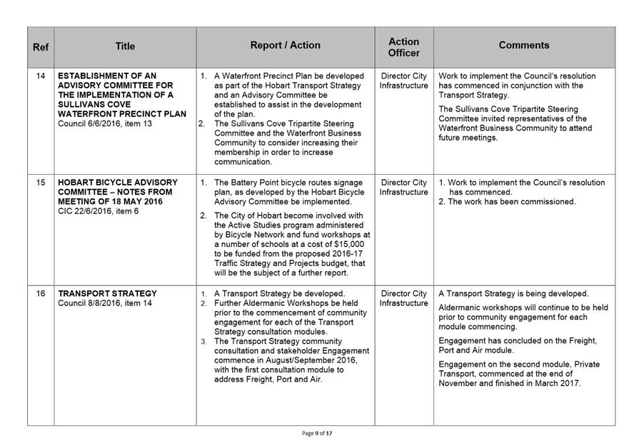
at 5.00 pm
Lady Osborne Room, Town Hall
THE MISSION
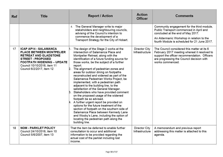
Our mission is to ensure good governance of our capital City.
THE VALUES
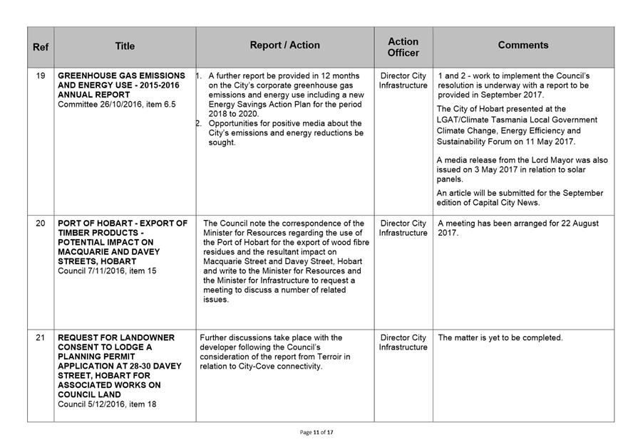
The Council is:
|
about people |
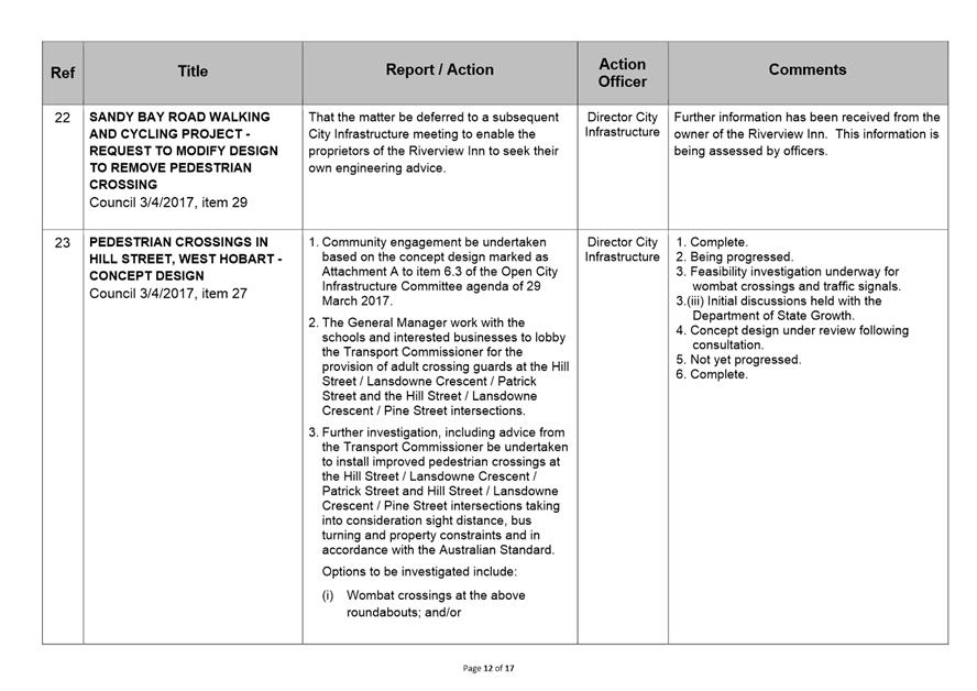
We value people – our community, our customers and colleagues. |
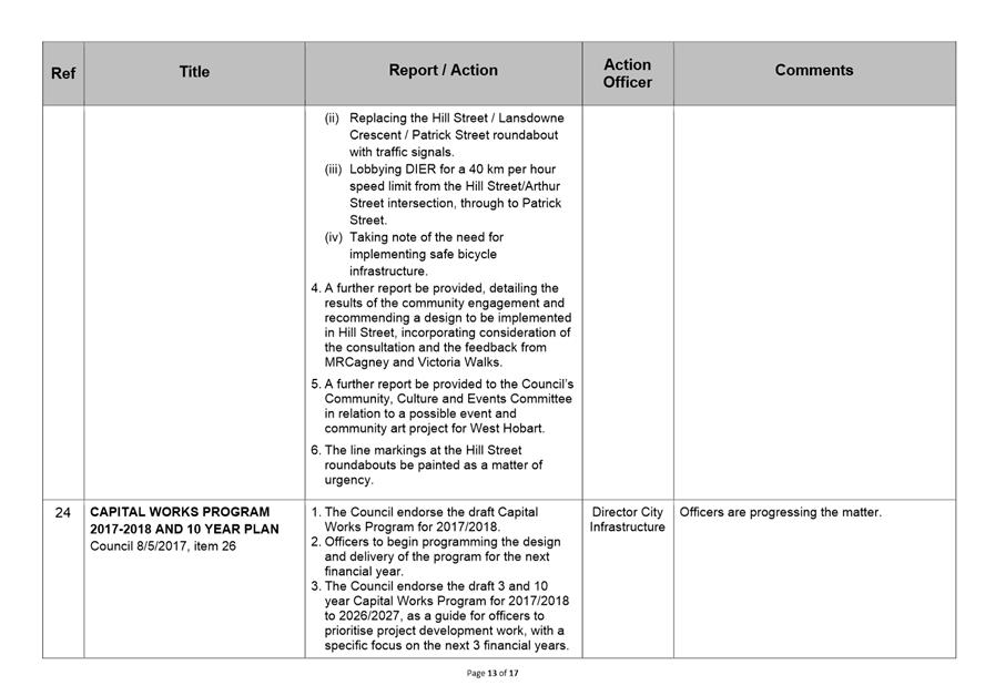
|
professional |
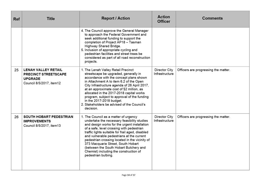
We take pride in our work. |
|
enterprising |
We look for ways to create value. |
|
responsive |
We’re accessible and focused on service. |
|
inclusive |
We respect diversity in people and ideas. |
|
making a difference |
We recognise that everything we do shapes Hobart’s future. |
|
|
Agenda (Open Portion) City Infrastructure Committee Meeting |
Page 3 |
|
|
21/6/2017 |
|
Business listed on the agenda is to be conducted in the order in which it is set out, unless the committee by simple majority determines otherwise.
APOLOGIES AND LEAVE OF ABSENCE
1. Co-Option of a Committee Member in the event of a vacancy
3. Consideration of Supplementary Items
4. Indications of Pecuniary and Conflicts of Interest
6.1 Collins Court Redevelopment - Stage Two
6.4 Development of a Parklet Policy - Response to Notice of Motion
7 Motions of which Notice has been Given
7.1 Potential Permanent Partial Road Closure in Campbell Street, Hobart
7.2 Transferring the Control and Ownership of Davey and Macquarie Streets to the State Government
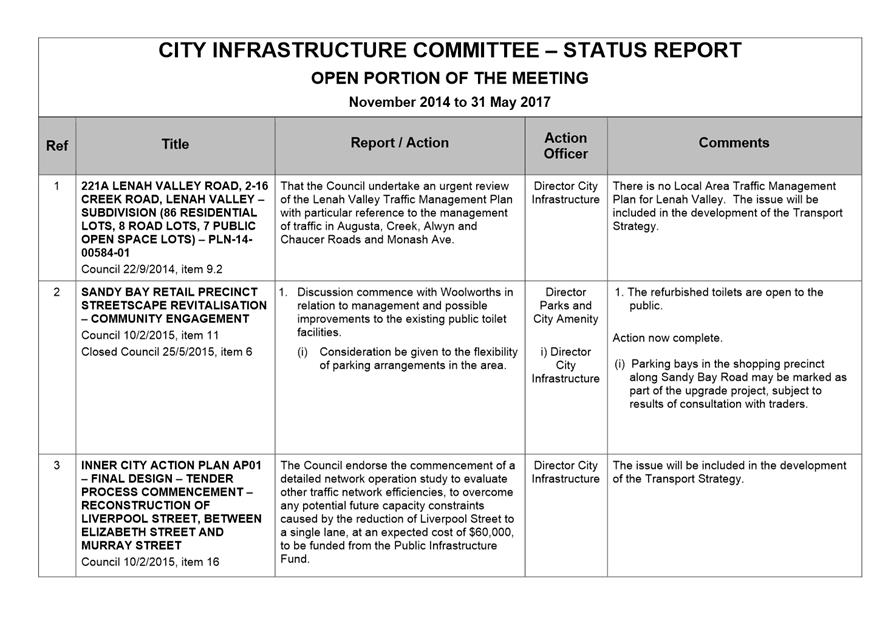
8 Committee Action Status Report
8.1 Committee Actions - Status Report
9. Responses to Questions Without Notice
9.1 Burnett Street Pedestrian Refuge
9.2 Street Trees - Lower Jordan Hill Road, Mount Stuart
11. Closed Portion Of The Meeting
|
|
Agenda (Open Portion) City Infrastructure Committee Meeting |
Page 5 |
|
|
21/6/2017 |
|
City Infrastructure Committee Meeting (Open Portion) held Wednesday, 21 June 2017 at 5.00 pm in the Lady Osborne Room, Town Hall.
|
COMMITTEE MEMBERS Burnet (Chairman) Deputy Lord Mayor Christie Reynolds Denison Harvey
ALDERMEN Lord Mayor Hickey Zucco Briscoe Ruzicka Sexton Cocker Thomas |
Apologies: Nil.
Leave of Absence: Deputy Lord Mayor R G Christie.
|
|
The minutes of the Open Portion of the City Infrastructure Committee meeting held on Wednesday, 24 May 2017, are submitted for confirming as an accurate record.
|
Ref: Part 2, Regulation 8(6) of the Local Government (Meeting Procedures) Regulations 2015.
|
That the Committee resolve to deal with any supplementary items not appearing on the agenda, as reported by the General Manager.
|
Ref: Part 2, Regulation 8(7) of the Local Government (Meeting Procedures) Regulations 2015.
Aldermen are requested to indicate where they may have any pecuniary or conflict of interest in respect to any matter appearing on the agenda, or any supplementary item to the agenda, which the committee has resolved to deal with.
Regulation 15 of the Local Government (Meeting Procedures) Regulations 2015.
A committee may close a part of a meeting to the public where a matter to be discussed falls within 15(2) of the above regulations.
In the event that the committee transfer an item to the closed portion, the reasons for doing so should be stated.
Are there any items which should be transferred from this agenda to the closed portion of the agenda, or from the closed to the open portion of the agenda?
|
Agenda (Open Portion) City Infrastructure Committee Meeting |
Page 6 |
|
|
|
21/6/2017 |
|
6.1 Collins Court Redevelopment - Stage Two
File Ref: F17/46652
Report of the Executive Manager City Design and the Director City Planning of 15 June 2017 and attachment.
Delegation: Council
|
Item No. 6.1 |
Agenda (Open Portion) City Infrastructure Committee Meeting |
Page 8 |
|
|
21/6/2017 |
|
REPORT TITLE: Collins Court Redevelopment - Stage Two
REPORT PROVIDED BY: Executive Manager City Design
Director City Planning
1. Report Purpose and Community Benefit
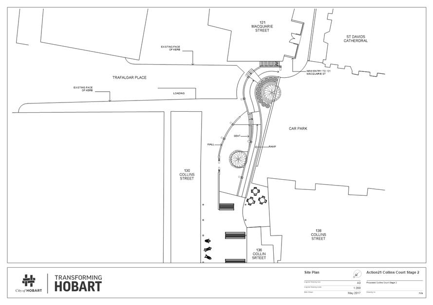
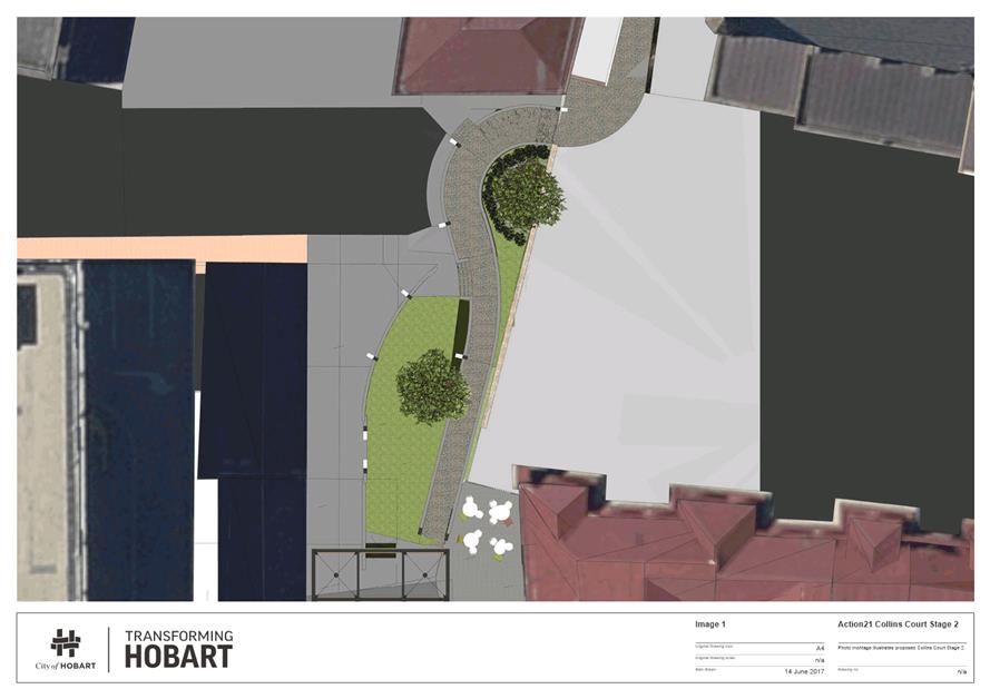
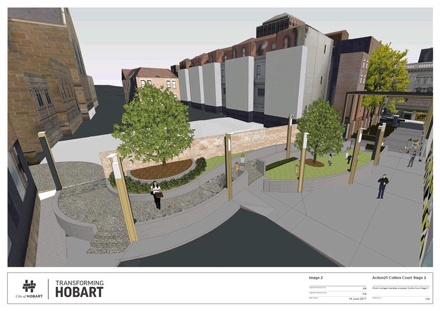
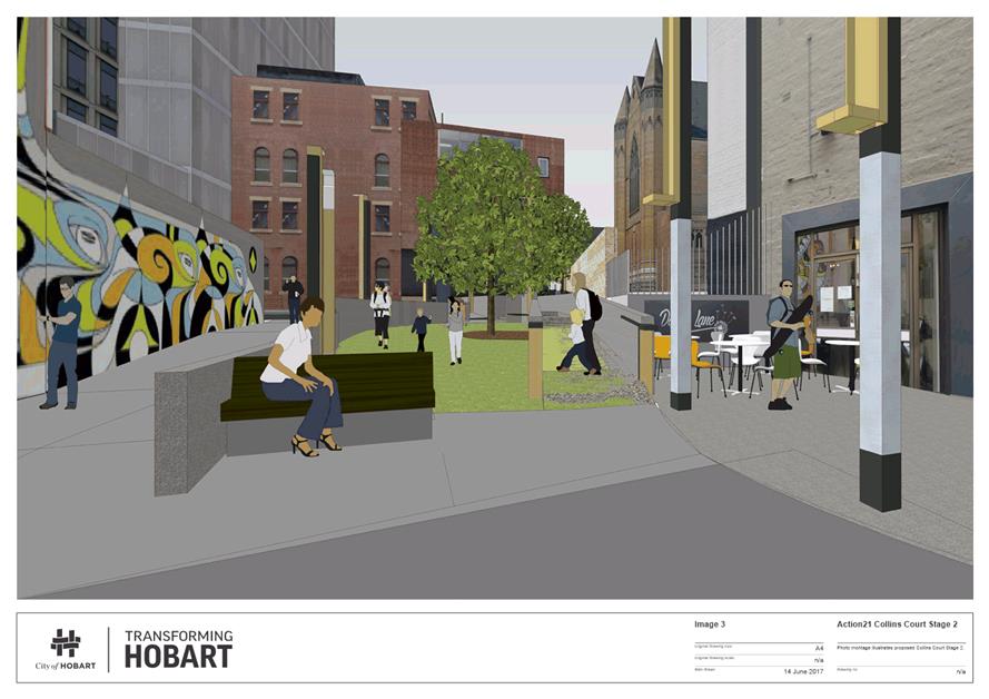
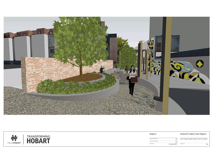
1.1. The first stage of the Collins Court Redevelopment is completed and has been a significant activities and animation place in the inner city. It is now proposed to complete the redevelopment by firstly seeking endorsement for public consultation of the second and final stage of the redevelopment connecting Collins Court through to the St David’s Cathedral to Macquarie Street including a play space for children.
1.2. The second stage of the redevelopment (Attachment A) is designed to improve the connectivity through the city block bordered by Collins, Elizabeth, Macquarie and Murray Streets and to increase the activity offerings for children within the Hobart CBD.
2. Report Summary
2.1. This report seeks endorsement of the Council to proceed with formal stakeholder and wider community consultation on the second stage of the Collins Court Redevelopment. The first stage was completed in December 2015 and has become a comfortable inner city respite space.
2.2. The second stage of the redevelopment has been designed and proposes a number of elements including:
2.2.1. A safe parent and child activity area with an artificial turfed courtyard.
2.2.2. An all-abilities access ramp connecting Collins Court to the Cathedral carpark.
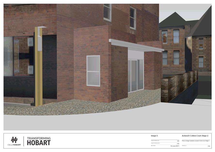
2.2.3. An improved connection to the Cathedral Green and Macquarie Street through a widened footpath between the northern end of St David’s Cathedral and the Hobart Mum’s Network. This will require the current lean-to section of the Hobart Mum’s Network building to be reduced in width providing an opportunity to provide an improved all-abilities access to the building.
That: 1. The Council endorse the design shown on Attachment A for the purpose of stakeholder and wider public engagement. 2. The outcomes of the stakeholder and wider public engagement in 1 above be the subject of a further report to the Council.
|
4. Background
4.1. Collins Court is at the heart of the City and for many years was considered unattractive and a gathering place for anti-social elements. The precursor to commencing the redevelopment of Collins Court was an extensive ‘Engagement’ process which included the place making workshops, the creation of the Future Collins Court - Place Story and establishment of the Collins Court Action Team, who comprise adjacent building owners, businesses and interested stakeholders.
4.2. The first stage of the redevelopment has resulted in a comfortable inner city respite space. The original design proposed, which could not proceed because of the delay in acquiring the access ramp to the St David’s Cathedral carpark, incorporated a deck and play structure at the Trafalgar Place end of the Court.
4.3. The Council has now acquired the access ramp allowing the completion of the redevelopment of Collins Court and the improved access through to Macquarie Street.
4.4. On reflection the originally proposed raised deck was considered problematic to manage and did not provide the access through to Macquarie Street that was desired by stakeholders. As a consequence, a review of the design was conducted and an alternative proposal developed. The hard paved space adjacent to Collins Street is proposed to be joined to a safe parent and child activity area with an artificial turfed courtyard and then via an all-abilities access ramp across Trafalgar Place and then across a corner of the Cathedral carpark, passed the new entry into the Hobart Mum’s Network and around the sandstone buildings of the Cathedral Green and hence to Macquarie Street.
Project Staging
4.5. The Collins Court – Stage Two sequence of works will include:
4.5.1. Construction of the connecting ramp between Collins Court and the Cathedral carpark.
4.5.2. Modifying the single storey lean-to section of the Hobart Mum’s Network to allow sufficient width for pedestrian access and to provide a new entry and storage space ground floor of the Mum’s Network tenancy.
4.5.3. Providing a safe non-slip surface to the ramp and all the way through to a connection to Macquarie Street.
4.5.4. Constructing the child friendly artificially turfed courtyard.
4.5.5. Providing a suitable night-time and events lighting system; with suitable electric power outlets and potable water outlets.
4.5.6. Providing green landscape elements to the area between the ramp and the existing heritage brick-wall the separates Collins Court from the Cathedral carpark.
4.5.7. Providing a suitable range of comfortable and durable furniture in the artificially turfed court-yard.
4.5.8. Certain design elements will be developed by a specialist consultant to enhance the enjoyment and experience of parents and children visiting the space.
Concept Design
4.6. The spatial design of Collins Court – Stage Two has been developed by the City Design Team and provides a high degree of access, connection, activity spaces while still maintaining an emergency vehicle access-way, three metres wide, and sufficient space in Trafalgar Place to allow a 6000mm delivery van vehicle to manoeuvre through a three point turn.
4.7. Specific design for children consultants will be engaged to ensure maximum effort is made to provide a space where parents and children can enjoy a safe stimulating environment during trips into the inner city.
5. Proposal and Implementation
5.1. It is proposed that the Council endorse the spatial design for Collins Court – Stage Two, shown on Attachment A to this report for the purpose of consulting with stakeholders and wider public. While preliminary discussions have been had with the Cathedral administration more detailed discussions will need to be had to reach agreement on the extent of works and activity to be carried out by the Council inside the Cathedral curtilage.
5.2. The engagement of a suitable design for children consultants to provide specific design elements to the benefit of parents and children using the space, has been the subject of a separate report to the Special Community Culture and Events Committee on 19 June 2017. The outcome of this consultancy will be incorporate into the final implementation of the project.
5.3. On completion of the consultation phase a further report will be submitted to the Council presenting a final recommendation on the form, extent, and cost of the works to be proposed.
6. Strategic Planning and Policy Considerations
6.1. Goal 2 of the Council’s Capital City Strategic Plan seeks to promote our City’s uniqueness, is people focused and provides connectedness and accessibility. These proposals are central to delivering an improved connected and accessible city centre.
7. Financial Implications
7.1. Funding Source and Impact on Current Year Operating Result
7.1.1. The public engagement program on the second stage of redevelopment of Collins Court would be conducted within the existing operational budget of the City Planning divisional allocation.
7.1.2. The anticipated cost of completing the currently proposed design for stage 2 is outlined below and would be funded from current allocations and carry forwards.
|
The basic infrastructure components will require approximately |
$300,000 |
|
The work within the Cathedral zone will require approximately |
$150,000 |
|
Urban furnishing elements and lighting are approximately |
$100,000 |
|
Public art allowance at 10% of project budget |
$55,000 |
|
Consultancies at 10% of project cost |
$55,000 |
|
Preliminary project cost estimate, say |
$660,000 |
7.1.3. The above figures are preliminary only and based on the current proposal. The design may ultimately change as a result of more detailed feedback from the Cathedral administration, and the public and other adjacent property owners.
7.2. Impact on Future Years’ Financial Result
7.2.1. None at this stage.
7.3. Asset Related Implications
7.3.1. This will be confirmed once a final design has been proposed.
8. Legal, Risk and Legislative Considerations
8.1. A Stakeholder Management Plan includes appropriate risk assessment and the stakeholder management strategy.
8.2. Any commitment of funds for works in the Cathedral curtilage will require a legally binding commitment to allow the public to traverse through the grounds of the Cathedral. This will be discussed as part of the more detailed engagement with the Cathedral administration.
9. Environmental Considerations
9.1. Improving pedestrian movement within the CBD is designed to make walking a more attractive experience for the many workers, visitors and residents that walk through the city.
10. Social and Customer Considerations
10.1. Collins Court sits in the heart of the city centre and has the potential to expand its function as an attractive community space to one that provides an engaging space for children as well as a much improved pedestrian link to many of Hobart’s busiest streets and areas including Collins Street, Macquarie Street and Murray Street as well as St David’s Cathedral, the Bus Mall and Franklin Square.
11. Marketing and Media
11.1. There will be interest in the next stage of improvements to Collins Court and it would be appropriate to comment if and when the Council formally embarks on a public consultation process with the preliminary design.
12. Community and Stakeholder Engagement
12.1. Consultations with the Director City Planning, Director Community Development, Executive Manager City Design, Manager Community and Cultural Projects, Manager Traffic Engineering and the Cultural Programs Co-ordinator has been undertaken in the preparation of this report.
12.2. Consultation has been undertaken with the external Collins Court Action Team, this includes adjacent building owners, businesses, the Cathedral, interested stakeholders and other members of the community.
12.3. Should the Council agree to release the proposed design for stage 2 for formal stakeholder and wider community consultation then an engagement plan will be developed with the existing Collins Court Action Team being central to such a plan.
13. Delegation
13.1. This is a matter for determination by the Council.
As signatory to this report, I certify that, pursuant to Section 55(1) of the Local Government Act 1993, I hold no interest, as referred to in Section 49 of the Local Government Act 1993, in matters contained in this report.
|
George Wilkie Executive Manager City Design |
Neil Noye Director City Planning |
Date: 15 June 2017
File Reference: F17/46652
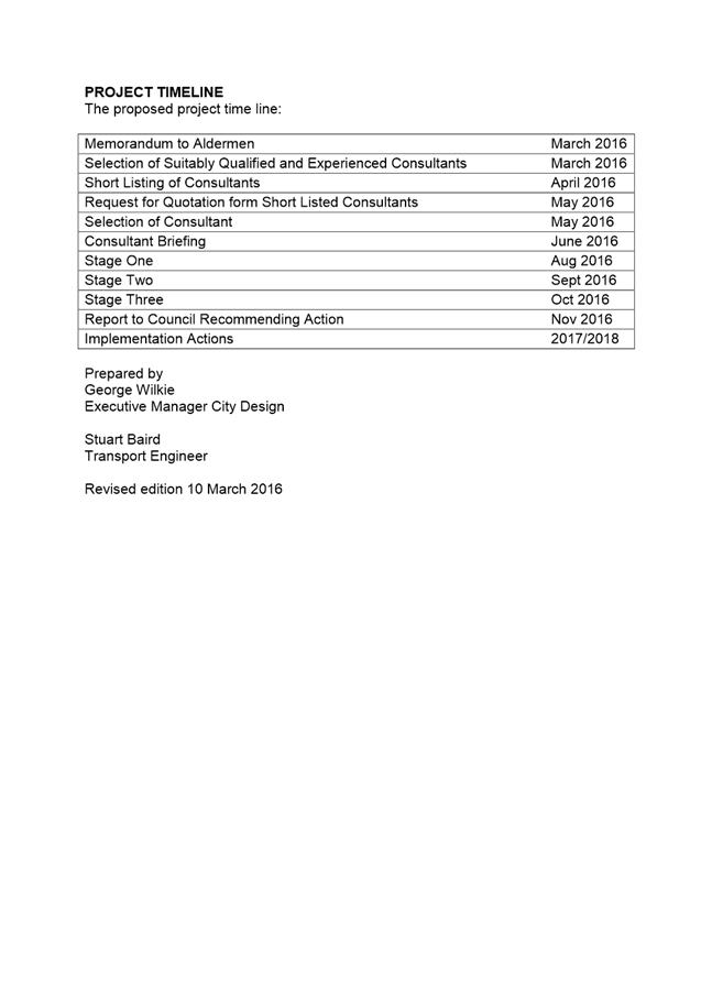
Attachment a: Collins
Court Stage 2 Preliminary Design ⇩ ![]()
|
Item No. 6.1 |
Agenda (Open Portion) City Infrastructure Committee Meeting - 21/6/2017 |
Page 14 ATTACHMENT a |
|
Agenda (Open Portion) City Infrastructure Committee Meeting |
Page 20 |
|
|
|
21/6/2017 |
|
File Ref: F17/49937
Report of the Executive Manager City Design and the Director City Planning of 16 June 2017 and attachments.
Delegation: Council
|
Item No. 6.2 |
Agenda (Open Portion) City Infrastructure Committee Meeting |
Page 22 |
|
|
21/6/2017 |
|
REPORT TITLE: City to Cove Connections
REPORT PROVIDED BY: Executive Manager City Design
Director City Planning
1. Report Purpose and Community Benefit
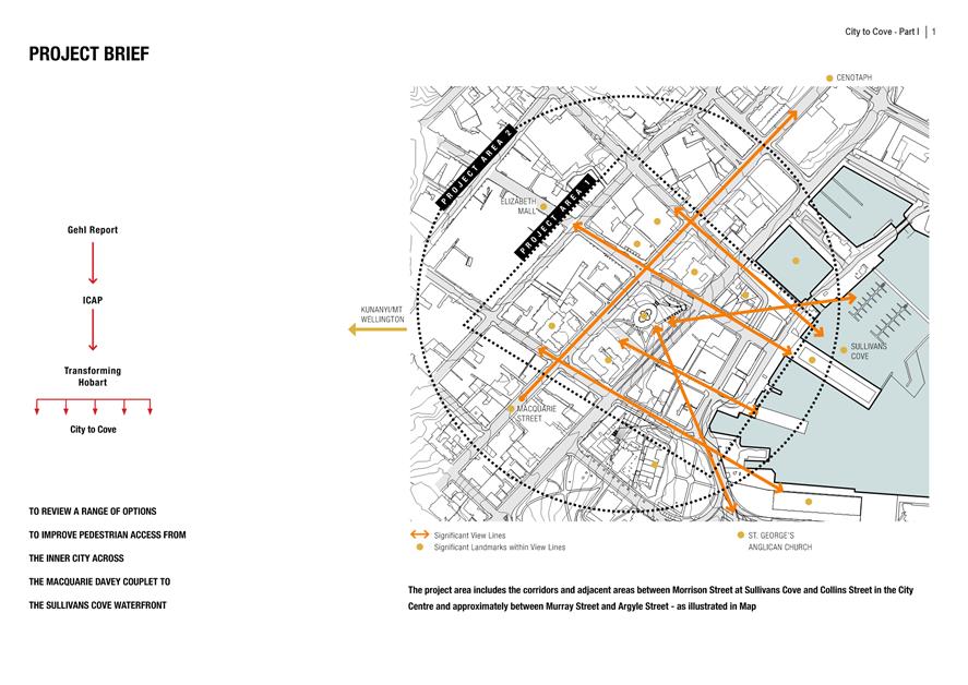
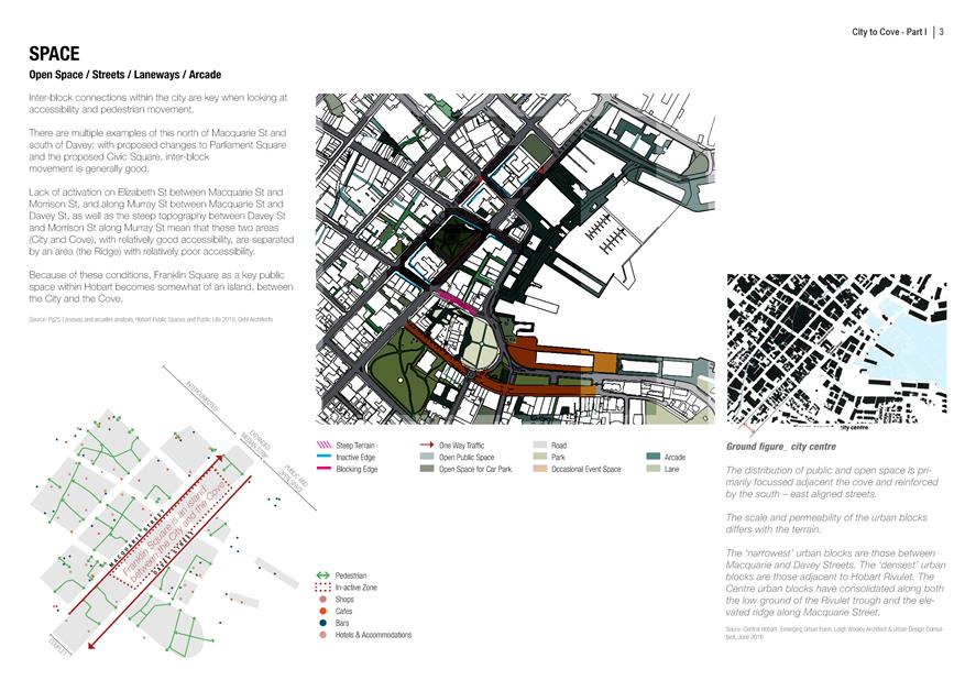
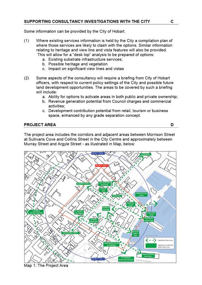
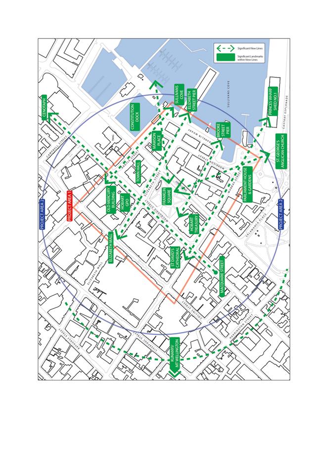
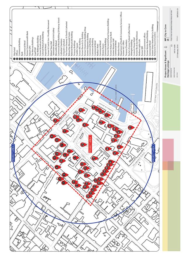
1.1. The purpose of this report is to present analysis of possible locations and to provide a range of concepts for improved pedestrian connection between the inner City and Sullivans Cove.
1.2. Terroir Architects were commissioned to investigate a wide range of options to improve public pedestrian and cyclist connections. Terroir’s City to Cove Report outlines the options for addressing the need for better pedestrian and cycling connections. An executive summary of the report is attached with the complete report circulated under separate cover.
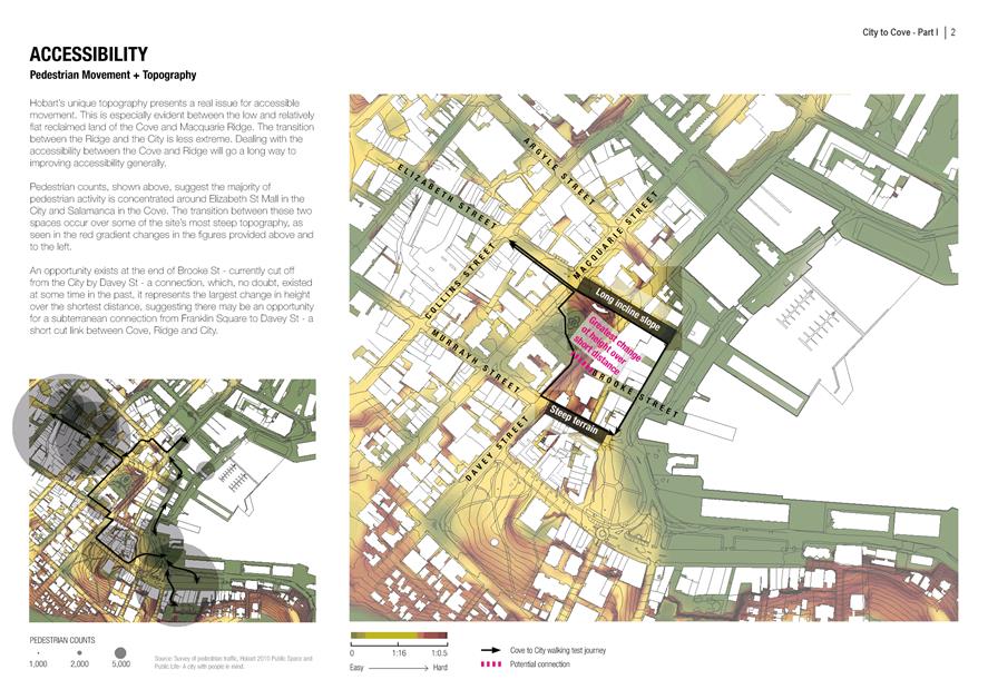
1.3. Currently access from the inner City to Sullivans Cove and other water front locations is significantly limited by:
1.3.1. The present requirement to cross the Macquarie/Davey Streets couplet at traffic lights.
1.3.2. The narrow width of many of the pedestrian foot paths compared with the current number of pedestrians using them.
1.3.3. The steep slope of some sections of streets between the inner City and the Cove area.
2. Report Summary
2.1. Terroir Architects have investigated a wide range of possible locations and types of connections within an area bounded by Harrington Street, Brisbane Street, Campbell Street and the Hobart Waterfront.
2.2. They have prepared the City to Cove, Hobart Report for the Councils consideration.
2.3. They also commissioned a number of supplementary reports:
2.3.1. GHD; Traffic and Pedestrian Advice.
2.3.2. Matrix Management Group; Quantity Survey.
2.3.3. Michael Connell and Associates; Economic Analysis.
2.3.4. Michael Small Consulting; Access Consulting.
2.4. The report while outlining a number of substantial interventions to improve the connectivity between the City to Cove recommend two options for consideration in the short to medium timeframe.
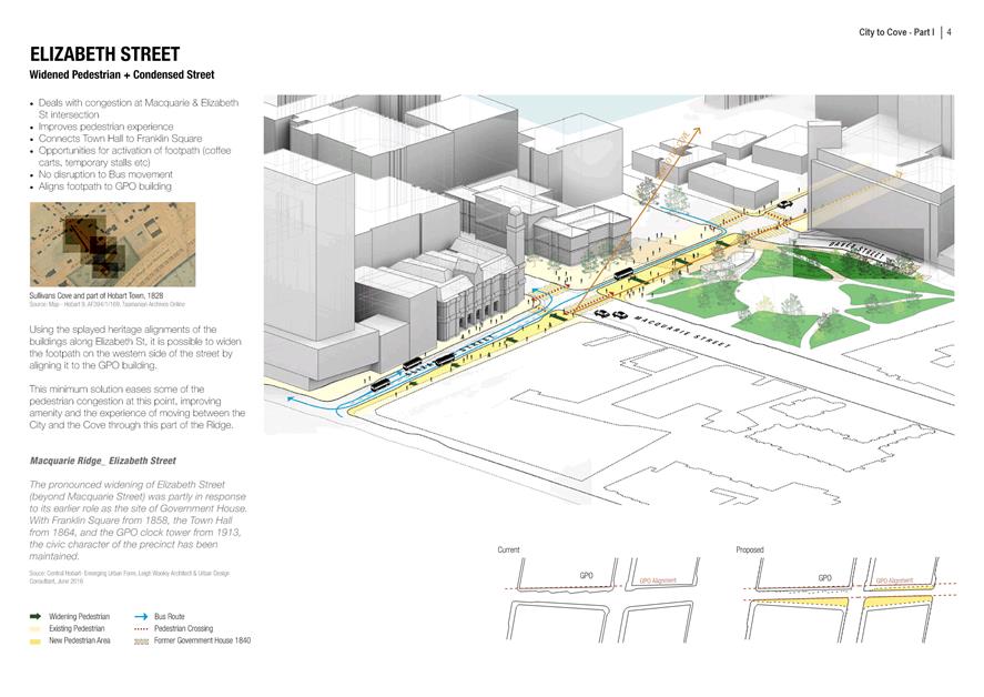
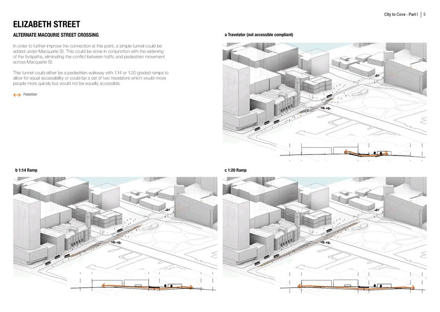
2.4.1. Widening the footpath and condensing the vehicle carriageway in Elizabeth Street between Collins Street and Franklin Wharf.
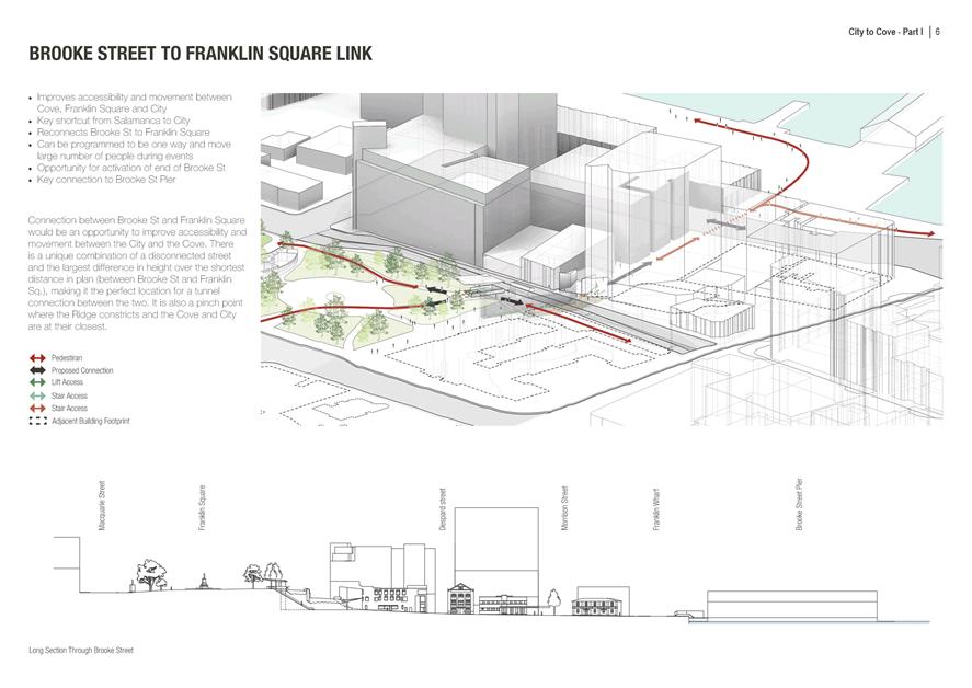
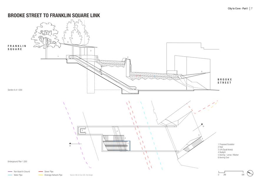
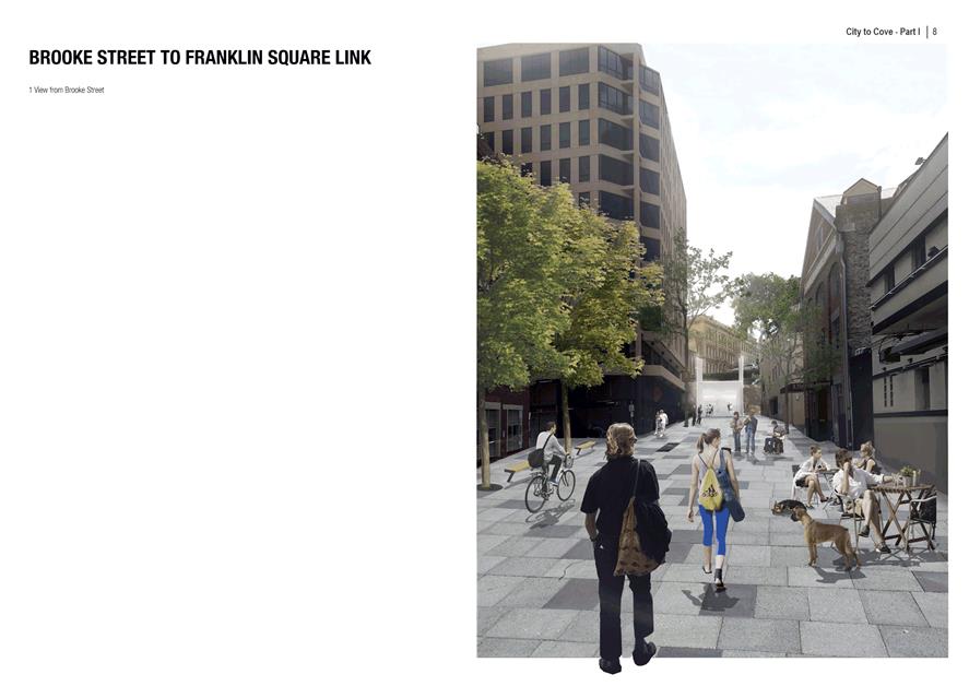
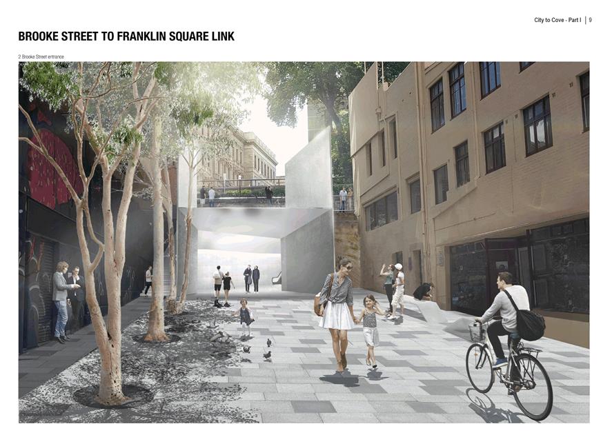
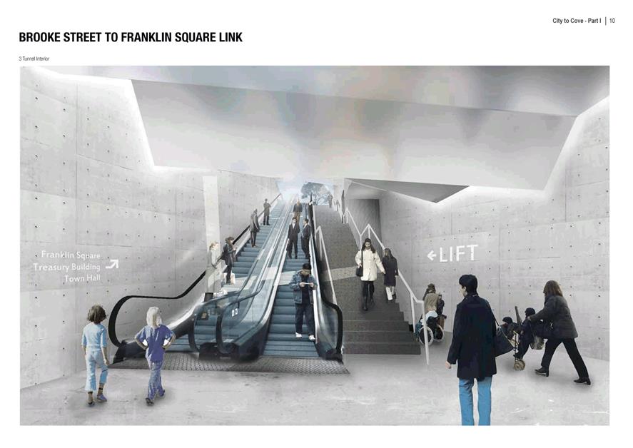
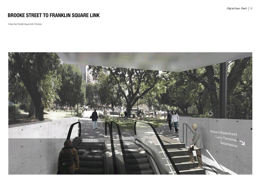
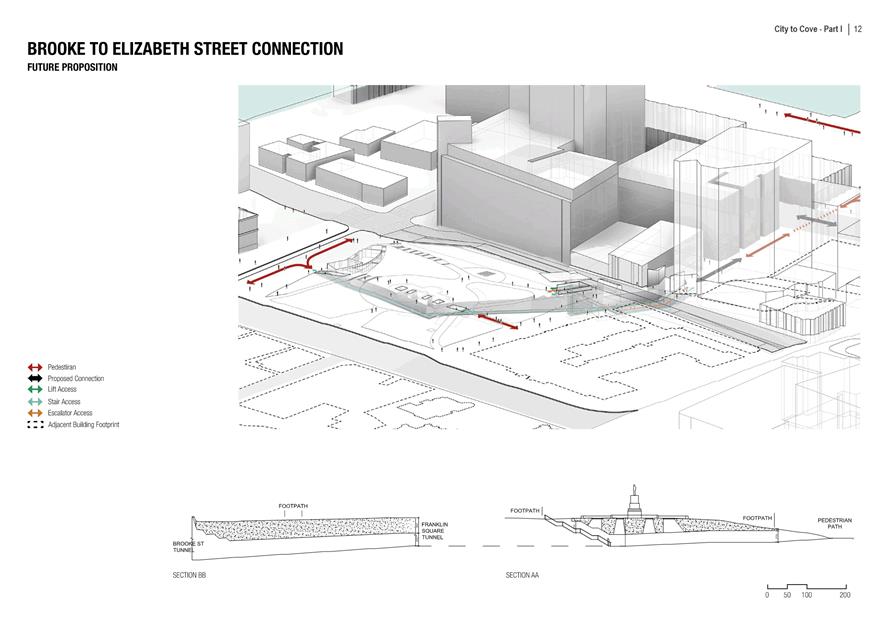
2.4.2. Brooke Street to Franklin Square link with the use of escalators stairs and a lift connecting under Davey Street.
|
That: 1. That widening the footpaths in Elizabeth Street, from Collins Street, to Franklin Wharf be considered as an integral component of the Elizabeth Street Bus Mall Improvement project. 2. That community engagement be conducted on the proposed Brooke Street to Franklin Square link as outlined in the Terroir Architects Hobart - City to Cove report. 3. The outcomes of the community consultation in 2 above be the subject of a further report to the Council.
|
4. Background
4.1. The Inner City Action Plan – Action Three (ICAP-AP03), recommended a number of actions to improve Pedestrian and Cyclist Access in Lower Elizabeth Street.
4.2. The Council at its meeting of 22 June 2015 considered a report relating to major works projects. In particular the Council, at that meeting, resolved that:
4.2.1. ‘The Council approve the development of a feasibility study into possible options to link the CBD to the waterfront, resolving pedestrian issues with crossing Macquarie and Davey Streets, in the 2015/16 financial year.’
4.3. Council at its meeting of 10 August 2015 subsequently approved the expenditure of up to $150 000 from the public infrastructure fund for the purposes of this study, taking into account the recommendations contained within the Gehl report of 2010 and the Inner City Action Plan project number AP03.
4.4. In order to progress this matter, a consultant’s brief (attached) was prepared and a tender was called. Terroir Architects were successful in this tender process
5. Proposal and Implementation
5.1. The option to widening the footpaths in Elizabeth Street, from Collins Street, across Macquarie Street, Davey Street, Morrison Street through to Franklin Wharf, should be considered in association with the proposed changes to the Bus Mall. Although the City to Cove Report indicates options to use grade separation measures to allow pedestrians and even traffic to pass under Macquarie Street, the current recommendation would review and develop the most suitable at-grade options.
5.2. The option for a grade separation of Davey Street, at Brooke Street, to allow pedestrian access to move under Davey Street and then to access Franklin Square via; escalators, stairs and an elevator, is a more complex option. This project requires detailed evaluation of site levels and sub-grade conditions, these should be undertaken and the potential of this option further developed. The ability of this project to be extended under Franklin Square through to Elizabeth Street adds further dimension to its consideration although is not recommended to pursue this extension at this stage. It is recommended that appropriate documentation be prepared to allow public and stakeholder consultation on this proposal so that the Council can consider whether it wishes to further progress this initiative.
6. Strategic Planning and Policy Considerations
6.1. Goal 2 of the Council’s Capital City Strategic Plan seeks to promote our City’s uniqueness, is people focused and provides connectedness and accessibility. These proposals are central to delivering an improved connected and accessible city centre.
7. Financial Implications
7.1. Funding Source and Impact on Current Year Operating Result
7.1.1. The public engagement program with the two recommended improvements would be conducted within the existing operational budget of the City Planning divisional allocation.
7.2. Impact on Future Years’ Financial Result
7.2.1. Allocations within the 10 Years Capital Works Program have been made for both the bus mall improvement project (a total $3 million made up of carry forwards and 18/19 financial year allocation) and the City to Cove pedestrian improvement project ($4 million – 21/22 financial year). The initial costing for the Brooke Street to Franklin Square link is $7 million. The final costing can only be determined following a more detailed design process and therefore any ultimate short fall in funding of the works would need to be made up of contributions from other sources or additional allocations within the capital works budget should the Council wish to proceed with such a project.
7.3. Asset Related Implications
7.3.1. Asset related implications would need to be calculated on a definitive proposals if and when they are progressed to detail planning phase of the assessment process.
8. Legal, Risk and Legislative Considerations
8.1. With any major intervention in the fabric of the City will come with some risk. Clearly the risk of not undertaking these interventions means that the pedestrian amenity of the City is not as positive as it could be. The risk of public consultation at the next phase will need to be managed to maximise the benefit of conducting such an exercise and will be done so with the assistance of the relevant Council staff and mediums.
9. Environmental Considerations
9.1. Improving pedestrian movement between the CBD and the Cove is designed to make walking a more attractive experience for the many workers, visitors and residents that traverse this route which in 2010 amounted to over 100,000 people per week during the summer period.
10. Social and Customer Considerations
10.1. Many people could benefit from improved connection from the City to the Cove and should be given the opportunity to comment on the City to Cove options.
10.2. The growth of the tourist industry in central Hobart will continue to put pressure on the need for convenient City to Cove connections. The current trend is for major new hotel developments and night economy offerings to be located on either side of the Macquarie/Davey Couplet. The tourism industry stakeholders will be important partners in any improvement to the City to Cove connection and need to be brought in to the evaluation of the benefits of any connection proposed. Other stakeholders such as Metro and the wider public also need to be given the opportunity to comment on the benefits and costs of such proposals.
11. Marketing and Media
11.1. There will be considerable interest in such improvements and it would be appropriate to comment on the initial recommendation for public engagement shortly after this report is considered and in a more significant way if and when the Council formally embarks on a public consultation process with either of these proposals.
12. Community and Stakeholder Engagement
12.1. The wider community has long requested improved connections from the City to the Cove. The Terroir Architects proposals provide a strong basis to engage with the wider Hobart community on this issue. It is proposed that the next step in progressing these two proposals is to develop an engagement plan that allows for meaningful input into these proposals and give the Council an opportunity to determine whether it wishes to proceed with them.
As signatory to this report, I certify that, pursuant to Section 55(1) of the Local Government Act 1993, I hold no interest, as referred to in Section 49 of the Local Government Act 1993, in matters contained in this report.
|
George Wilkie Executive Manager City Design |
Neil Noye Director City Planning |
Date: 16 June 2017
File Reference: F17/49937
Attachment a: City
to Cove Executive Summary ⇩ ![]()
Attachment b: City to Cove Full Report (Under separate cover) (Confidential)
Attachment
c: City
to Cove Brief ⇩ ![]()
|
Item No. 6.2 |
Agenda (Open Portion) City Infrastructure Committee Meeting - 21/6/2017 |
Page 26 ATTACHMENT a |
|
Item No. 6.2 |
Agenda (Open Portion) City Infrastructure Committee Meeting - 21/6/2017 |
Page 27 ATTACHMENT a |
|
Item No. 6.2 |
Agenda (Open Portion) City Infrastructure Committee Meeting - 21/6/2017 |
Page 28 ATTACHMENT a |
|
Item No. 6.2 |
Agenda (Open Portion) City Infrastructure Committee Meeting - 21/6/2017 |
Page 29 ATTACHMENT a |
|
Item No. 6.2 |
Agenda (Open Portion) City Infrastructure Committee Meeting - 21/6/2017 |
Page 30 ATTACHMENT a |
|
Item No. 6.2 |
Agenda (Open Portion) City Infrastructure Committee Meeting - 21/6/2017 |
Page 31 ATTACHMENT a |
|
Item No. 6.2 |
Agenda (Open Portion) City Infrastructure Committee Meeting - 21/6/2017 |
Page 32 ATTACHMENT a |
|
Item No. 6.2 |
Agenda (Open Portion) City Infrastructure Committee Meeting - 21/6/2017 |
Page 33 ATTACHMENT a |
|
Item No. 6.2 |
Agenda (Open Portion) City Infrastructure Committee Meeting - 21/6/2017 |
Page 34 ATTACHMENT a |
|
Item No. 6.2 |
Agenda (Open Portion) City Infrastructure Committee Meeting - 21/6/2017 |
Page 35 ATTACHMENT a |
|
Item No. 6.2 |
Agenda (Open Portion) City Infrastructure Committee Meeting - 21/6/2017 |
Page 36 ATTACHMENT a |
|
Item No. 6.2 |
Agenda (Open Portion) City Infrastructure Committee Meeting - 21/6/2017 |
Page 37 ATTACHMENT a |
|
Item No. 6.2 |
Agenda (Open Portion) City Infrastructure Committee Meeting - 21/6/2017 |
Page 38 ATTACHMENT a |
|
Item No. 6.2 |
Agenda (Open Portion) City Infrastructure Committee Meeting - 21/6/2017 |
Page 39 ATTACHMENT a |
|
Item No. 6.2 |
Agenda (Open Portion) City Infrastructure Committee Meeting - 21/6/2017 |
Page 40 ATTACHMENT a |
|
Item No. 6.2 |
Agenda (Open Portion) City Infrastructure Committee Meeting - 21/6/2017 |
Page 43 ATTACHMENT c |
|
Agenda (Open Portion) City Infrastructure Committee Meeting |
Page 59 |
|
|
|
21/6/2017 |
|
6.3 Outdoor Dining and Umbrella Infrastructure - 61 & 63 Salamanca Place between Kennedy Land and Wooby's Lane
File Ref: F17/60517; R0817
Report of the Director City Infrastructure and the Director City Planning of 15 June 2017 and attachments.
Delegation: Committee
|
Item No. 6.3 |
Agenda (Open Portion) City Infrastructure Committee Meeting |
Page 61 |
|
|
21/6/2017 |
|
REPORT TITLE: Outdoor Dining and Umbrella Infrastructure - 61 & 63 Salamanca Place between Kennedy Land and Wooby's Lane
REPORT PROVIDED BY: Director City Infrastructure
Director City Planning
1. Report Purpose and Community Benefit
1.1. This report has been written to advise the Committee of two requests for the installation of umbrellas in the footpath on the southern side of Salamanca Place between Kennedy Lane and Wooby’s Lane.
1.2. Guidance is sought from the Committee on how these applications and future similar applications that may be received, are to be considered prior to the consideration of the future direction for the management of street furniture on this section of Salamanca Place, which is expected to be considered by the Council in 2018.
2. Report Summary
2.1. A request has been received from ‘Liv Eat’ and from ‘VK Salamanca Pty Ltd’ for the placement of furniture to facilitate outdoor dining on the southern footpath of Salamanca Place in front of 61 and 63 Salamanca Place. This request includes a request for the installation of large fixed umbrellas.
2.2. In recent years, the Council has resolved to pursue a policy of moving to have outdoor dining furniture, 'A-frame' signage, and other infrastructure aligned clear of the building line, to provide a clear and accessible path of travel for pedestrians.
2.3. The section of Salamanca Place where these businesses are situated, the southern footpath between Wooby’s Lane and Kennedy Lane, will be the subject of a report seeking a future direction from the Council on the management of pedestrian paths and street furniture. The report will be prepared about six months after the completion of works on the new footpath on Salamanca Place between Montpelier Retreat and Gladstone Street.
2.4. This then leaves essentially an 8 to 10 month period of uncertainty about the future direction for the footpath between Kennedy Lane and Wooby’s Lane.
2.5. It is therefore recommended that additional fixed / permanent umbrellas only be considered if they would not compromise the possible future removal of the line of umbrellas closest to the building line on this section of Salamanca Place. Essentially this would mean no fixed / permanent umbrellas within 3 metres of the building façade.
2.6. The recommendations, that would apply until the Council resolves the future direction for the management of the southern footpath of Salamanca Place in 2018, would mean that both Liv Eat and VK Salamanca Pty Ltd would need to revise their applications.
2.7. A revised application, were it to be received, would be considered and actioned by officers utilising existing delegations.
|
That: 1. Until such time as the Council resolves the future direction for the management of the southern footpath on Salamanca Place between Montpelier Retreat and the Silos, the following guidelines apply: (i) The City of Hobart as highway authority only consider requests for the installation of additional fixed or permanent umbrellas on the southern footpath if the installation of those umbrellas would not conflict with the future provision of: (a) A 3 metre wide clear pedestrian path (that is not covered by umbrellas) adjacent to the building line; (b) A 1.5 metre wide clear pedestrian path (that is not covered by umbrellas) between outdoor dining furniture and parked cars; and (c) A 1.2 metre wide clear pedestrian path between outdoor dining areas. (ii) The City of Hobart as highway authority only consider requests for the installation of tables, chairs and barriers to facilitate outdoor dining that can be removed from the public footpath when not in use. (iii) Subject to the recommendations above, in relation to request for new or adjusted occupation licences for outdoor dining on the Salamanca Place southern footpath between Kennedy Lane and Wooby’s Lane, the City of Hobart as highway authority permit the installation of removable tables, chairs and barriers to facilitate outdoor dining on the equivalent alignment to those currently in front of the businesses Maldini, Jack Greene, Cargo and Grape. (iv) The General Manager advise any applicant considering the purchase and installation of furniture to place on the Salamanca Place footpath of the above recommendations, and further advise that until such time that the Council considers and resolves its future direction for the management of that footpath, that any furniture purchased and installed that is not compatible with the future direction may need to be removed at the applicant’s cost.
|
4. Background
4.1. A request has been received from ‘Liv Eat’ and from ‘VK Salamanca Pty Ltd’ for the placement of furniture to facilitate outdoor dining on the southern footpath of Salamanca Place in front of 61 and 63 Salamanca Place.
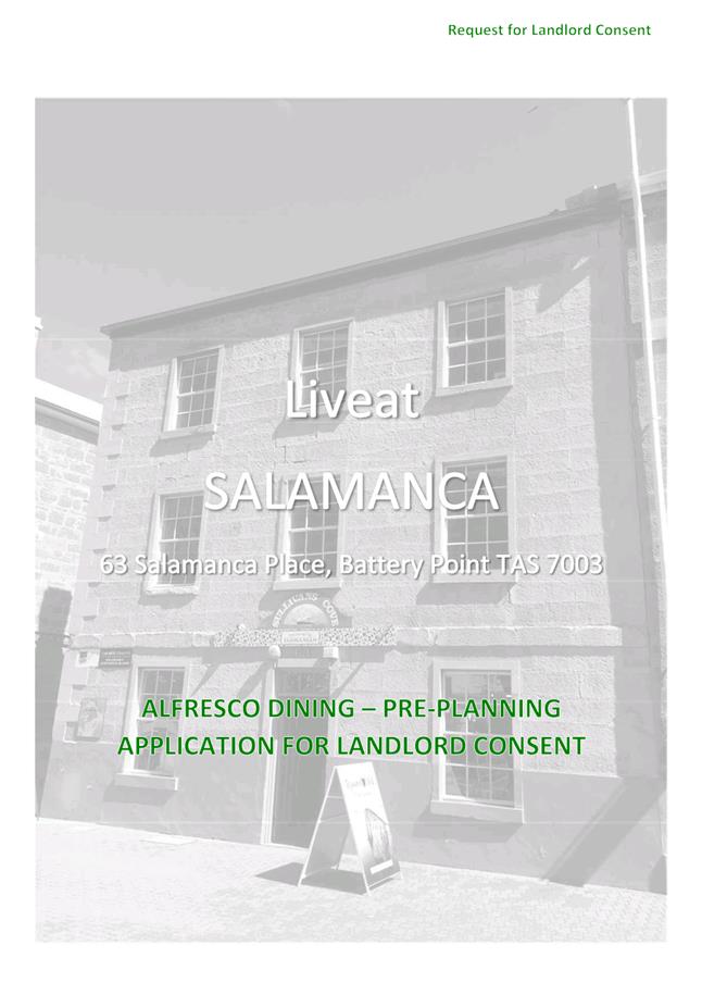
4.2. Liv Eat is currently in the process of seeking the necessary approvals to open a restaurant in 63 Salamanca Place. Their request forms Attachment A to D to this report.
![]()
![]()
![]()
![]()
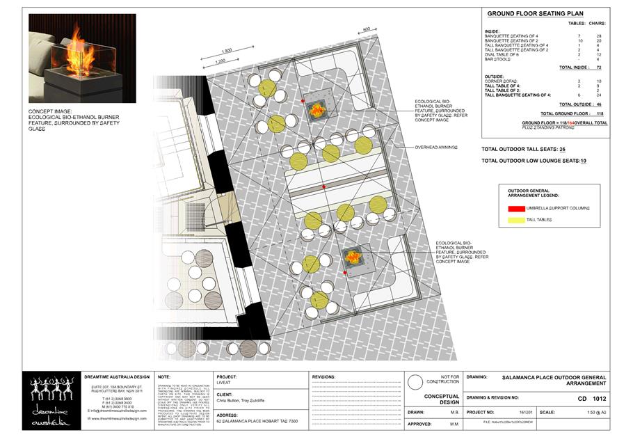
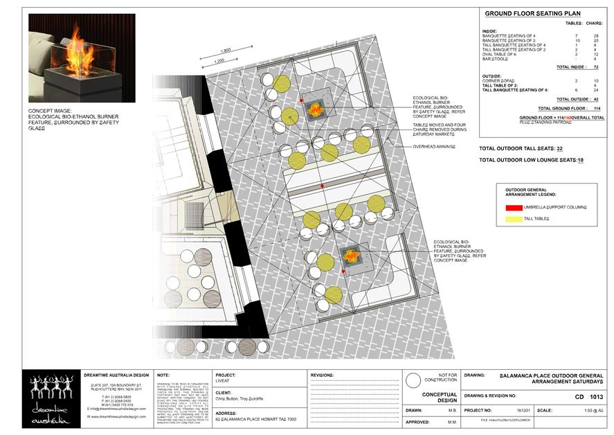
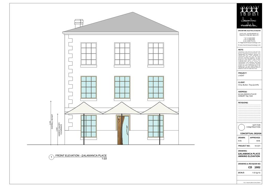
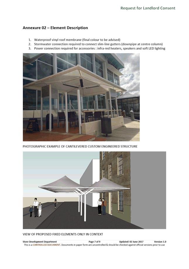
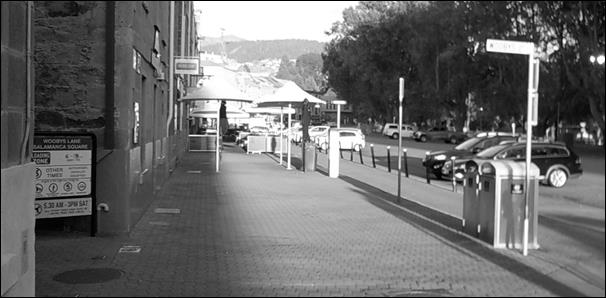 Figure 1 – 63 Salamanca
Place – Approximate Outdoor Dining Area
Figure 1 – 63 Salamanca
Place – Approximate Outdoor Dining Area
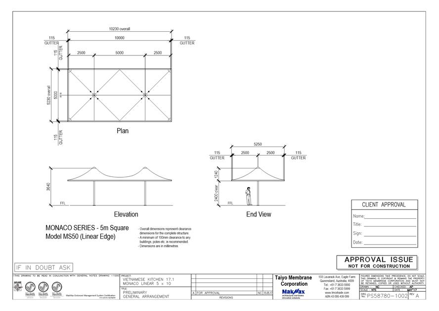
4.3. VK Salamanca Pty Ltd has acquired the leasehold of 61 Salamanca Place, currently occupied by the Vietnamese Kitchen. They are enquiring about installing larger umbrellas in the footpath in front of the premises. The initial concept plans for the umbrellas submitted by VK Salamanca Pty Ltd form Attachment E to this report.
![]()
![]()
![]()
![]()
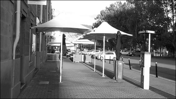 Figure 2 – 61 Salamanca
Place – Approximate Outdoor Dining Area
Figure 2 – 61 Salamanca
Place – Approximate Outdoor Dining Area
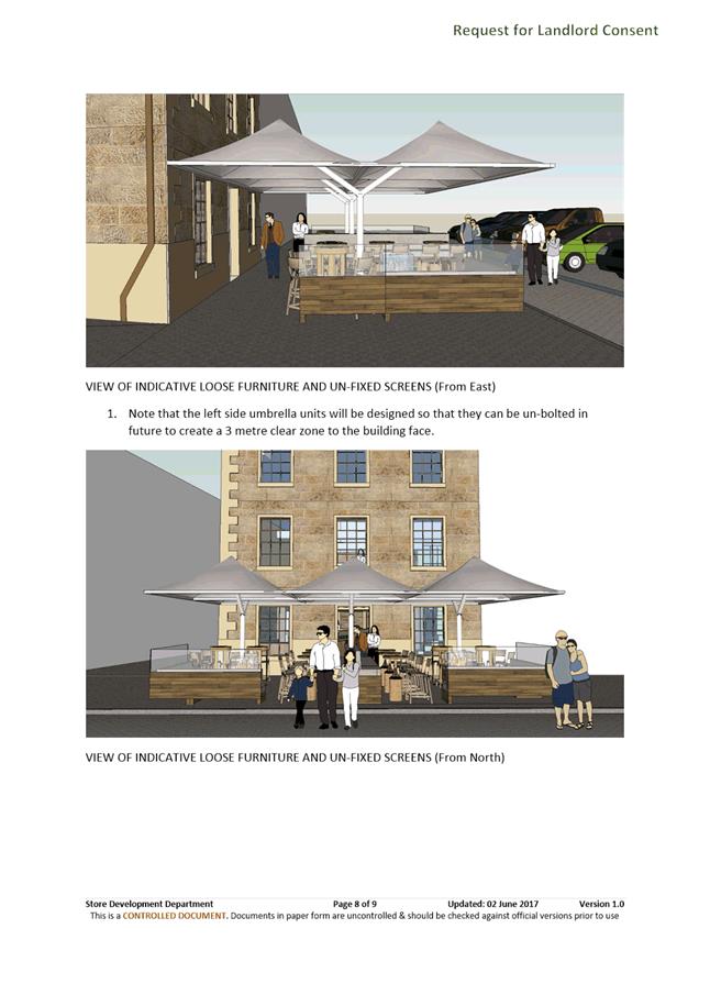
4.4. Both applications include fixed / permanent umbrella canopys that essentially cover the full width of the conventional footpath. This is in keeping with the current umbrella arrangements in place in front of a number of other businesses on the same section of the Salamanca Place footpath.
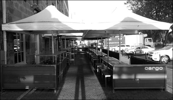 Figure 4 – Salamanca
Place (Kennedy Lane to Wooby’s Lane) – Typical Outdoor Dining
Furniture Layout
Figure 4 – Salamanca
Place (Kennedy Lane to Wooby’s Lane) – Typical Outdoor Dining
Furniture Layout
4.5. In recent years, the Council has resolved to pursue a policy of moving to have outdoor dining furniture, 'A-frame' signage, and other infrastructure aligned clear of the building line, to provide a clear and accessible path of travel for pedestrians.
4.6. Currently, the City is constructing a widened footpath on the southern side of Salamanca Place between Gladstone Street and Montpelier Retreat. When considering the design and future use of that section of footpath, the Council received representations about the placement and alignment of the outdoor dining areas on the footpath.
4.6.1. Businesses with outdoor dining, and their representative groups, tended to be strongly in favour of arrangements similar to those in place at Maldini, Jack Greene, Cargo and Grape (the layouts currently in place between Wooby’s Lane and Kennedy Lane), being also applied on the new footpath between Gladstone Street and Montpelier Retreat. These groups felt that this offered the best experience and conditions for their customers and staff.
4.6.2. Pedestrians with disabilities and their representative groups tended to be strongly in favour maintaining a clear pedestrian path against the building line. These groups felt that this alignment offered the best experience and conditions for pedestrians.
4.6.3. Some retail businesses (i.e. non hospitality businesses) were strongly of the view that outdoor dining areas should be moved away from the building line, to ensure that pedestrians walking along the footpath passed as close as possible to the windows and doors of those retail businesses.
4.7. After considering the various views, on 6 February 2017 the Council resolved the following:
"That: 1. The alignment of pedestrian zones and areas for outdoor dining on footpaths reconstructed and widened as part of the Salamanca Pedestrian Works Project, be implemented generally as shown on the plan titled 'Salamanca Place Footpath Widening Concept Plan', marked as Attachment E to item 6.1 of the Open City Infrastructure Committee agenda of 25 January 2017, with a pedestrian path adjacent to the building line, to the satisfaction of the General Manager.
2. Stakeholders who have provided comment on the proposed usage of the widened footpath be so advised.
3. A further urgent report be provided on options for the future treatment of the section of footpath on the southern side of Salamanca Place between Kennedy Lane and Wooby's Lane, including the option of locating the pedestrian path along the building line."
4.8. Based on this resolution, the future alignment of outdoor dining furniture on the footpath between Kennedy Lane and Wooby's Lane is clearly of interest to the Council.
4.9. The urgent report requested was presented to the City Infrastructure Committee on 29 March 2017.
4.10. In the report, it was essentially recommended that the future alignment of pedestrian paths and outdoor dining furniture on the footpath between Kennedy Lane and Wooby's Lane should ultimately be the same as that planned for the footpath between Gladstone Street and Montpelier Retreat, that is:
(i) A 3 metre wide clear pedestrian path (that is not covered by umbrellas) adjacent to the building line;
(ii) A 1.5 metre wide clear pedestrian path (that is not covered by umbrellas) between outdoor dining furniture and parked cars; and
(iii) A 1.2 metre wide clear pedestrian path between outdoor dining areas.
4.11. That alignment, as recommended in the report, was and remains the officer recommended future direction for the management of the southern footpath on Salamanca Place.
4.12. In the report, it was acknowledged that moving to this alignment between Wooby's Lane and Kennedy Lane would require the removal of the 11 umbrellas in the row closest to the building line that the businesses Maldini, Jack Greene, Cargo and Grape have purchased and installed.
4.13. The issue then was seen to be one of the timing of the removal of this row of umbrellas, and the balancing of the benefits to the community of moving to the new alignment against the loss of the investment in the umbrella infrastructure made by those businesses in good faith.
4.14. Given that the City was shortly to commence construction of the widened footpath in the Gladstone Street to Montpelier Retreat section, it was the officer recommendation that the final decision on this matter (how to manage the footpath between Kennedy Lane and Wooby’s Lane) be deferred until about 6 months after the new arrangement is in place, to allow an informed decision about the benefits of the two alignments to be compared and considered.
4.15. On 3 April 2017 the Council resolved the following:
"That: 1. Consideration of the future management of the section of the Salamanca Place southern footpath between Kennedy Lane and Wooby's Lane, occur once the 'Stage 1' footpath widening works have been completed and in operation for a minimum of six months.
2. The General Manager develop and implement a suitable guide for the style and placement of outdoor dining barriers and umbrellas to be utilised on Salamanca Place and Hunter Street.
3. A concept design addressing the pedestrian issue occurring on the northern side of Salamanca Place during periods when the footpaths on Castray Esplanade are inaccessible due to special events be developed and included for consideration in future budget preparations."
4.16. This then leaves essentially an 8 to 10 month period of uncertainty about the future direction for the footpath between Kennedy Lane and Wooby's Lane.
5. Proposal and Implementation
5.1. The request for the issue of an occupation licence for outdoor dining (in some form) would be considered appropriate in both locations.
5.2. Until such time as the future alignment of the outdoor dining areas and pedestrian paths on this footpath are resolved, it would be considered reasonable for either or both Liv Eat and VK Salamanca Pty Ltd to be issued an occupation licence for outdoor dining for an area equivalent in dimensions to that currently held by Maldini, Jack Greene and et al.
5.3. This approach would be supported by the Council decision relating to the transition to 'best practice' for clear pedestrian paths, where there is provision in the interim period for new outdoor dining licences that are on sections of footpath with non best-practice outdoor dining areas to be issued licences for that interim period, so that there is a consistent treatment for pedestrians along a section of footpath.
5.4. In terms of the installation of fixed / permanent umbrellas before the Council has resolved a final position, it may be appropriate for these to be supported, provided it was clearly understand that they may be required to be removed if they are not in keeping with the final Council position when that position is resolved.
5.4.1. This would however send a mixed message, with the City supporting the installation of new fixed / permanent umbrellas in positions that would be contrary to the ‘best practice’ approach to pedestrian amenity that the Council has resolved to move towards.
5.5. It is therefore recommended that additional fixed / permanent umbrellas only be considered if they would not compromise the possible future removal of the line of umbrellas closest to the building line on this section of Salamanca Place. Essentially this would mean no fixed / permanent umbrellas within 3m of the building façade.
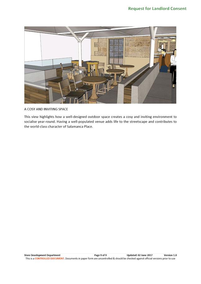
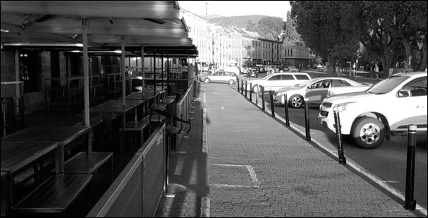 Figure 5 – Salamanca
Place (Kennedy Lane to Wooby’s Lane) – Informal Footpath
Figure 5 – Salamanca
Place (Kennedy Lane to Wooby’s Lane) – Informal Footpath
5.6. The recommendations, that would apply until the Council resolves the future direction for the management of the southern footpath of Salamanca Place in 2018, would mean that both Liv Eat and VK Salamanca Pty Ltd may need to revise their applications.
5.7. A revised application were it to be received, would be considered and actioned by officers utilising existing delegations.
6. Strategic Planning and Policy Considerations
6.1. Strategic objective 2.2 from the Capital City Strategic Plan 2015-2025 is relevant in considering this proposal, namely:
“A people focused city with well designed and well managed urban and recreational spaces.”
7. Financial Implications
7.1. Funding Source and Impact on Current Year Operating Result
7.1.1. None are foreseen at this time.
7.2. Impact on Future Years’ Financial Result
7.2.1. None are foreseen at this time.
7.3. Asset Related Implications
7.3.1. None are foreseen at this time.
8. Legal, Risk and Legislative Considerations
8.1. Section 23 of the Federal Disability Discrimination Act describe responsibilities for the provision of access for people with disabilities.
8.2. Section 23 of the Disability Discrimination Act 1992 states that:
“It is unlawful for a person to discriminate against another person on the ground of the other person’s disability:
(a) by refusing to allow the other person access to, or the use of, any premises that the public or a section of the public is entitled or allowed to enter or use (whether for payment or not); or
(b) in the terms or conditions on which the first‑mentioned person is prepared to allow the other person access to, or the use of, any such premises; or
(c) in relation to the provision of means of access to such premises; or
(d) by refusing to allow the other person the use of any facilities in such premises that the public or a section of the public is entitled or allowed to use (whether for payment or not); or
(e) in the terms or conditions on which the first‑mentioned person is prepared to allow the other person the use of any such facilities; or
(f) by requiring the other person to leave such premises or cease to use such facilities.”
8.3. Section 29A of the Disability Discrimination Act 1992 states that:
“This Division (other than Section 30) does not render it unlawful for a person (the discriminator) to discriminate against another person on the ground of a disability of the other person if avoiding the discrimination would impose an unjustifiable hardship on the discriminator:”
9. Community and Stakeholder Engagement
9.1. No direct community and stakeholder engagement has been undertaken in the preparation of this report.
9.2. The Senior Engineer Roads and Traffic and the Director Community Development have been consulted in the preparation of this report.
9.3. The report has however, been written taking into account the significant amount of stakeholder engagement that occurred during the process of preparing the various proposals and reports for the footpath widening works currently under construction, and the determination of how pedestrian paths and outdoor dining areas would be managed on the widened footpath after construction.
10. Delegation
10.1. The Director City Infrastructure has delegation to consider these matters. However, given the nature and complexity of the request, this matter has been referred to Committee to determine.
As signatory to this report, I certify that, pursuant to Section 55(1) of the Local Government Act 1993, I hold no interest, as referred to in Section 49 of the Local Government Act 1993, in matters contained in this report.
|
Mark Painter Director City Infrastructure |
Neil Noye Director City Planning |
Date: 15 June 2017
File Reference: F17/60517; R0817
Attachment a: Plan
for 63 Salamanca Place - Liv Eat Preliminary General Arrangement ⇩ ![]()
Attachment
b: Plan
for 63 Salamanca Place - Liv Eat Preliminary General Arrangement for Saturdays ⇩ ![]()
Attachment
c: Plan
for 63 Salamanca Place - Liv Eat Front Elevation ⇩ ![]()
Attachment
d: Report
for 63 Salamanca Place - Liv Eat Planning Application Report ⇩ ![]()
Attachment
e: Plan
for 61 Salamanca Place - Vietmamese Kitchen Preliminary General Arrangement ⇩ ![]()
|
Item No. 6.3 |
Agenda (Open Portion) City Infrastructure Committee Meeting - 21/6/2017 |
Page 70 ATTACHMENT a |
|
Agenda (Open Portion) City Infrastructure Committee Meeting - 21/6/2017 |
Page 71 ATTACHMENT b |
|
Agenda (Open Portion) City Infrastructure Committee Meeting - 21/6/2017 |
Page 72 ATTACHMENT c |
|
Agenda (Open Portion) City Infrastructure Committee Meeting - 21/6/2017 |
Page 75 ATTACHMENT d |
|
Agenda (Open Portion) City Infrastructure Committee Meeting - 21/6/2017 |
Page 82 ATTACHMENT e |
|
Agenda (Open Portion) City Infrastructure Committee Meeting |
Page 83 |
|
|
|
21/6/2017 |
|
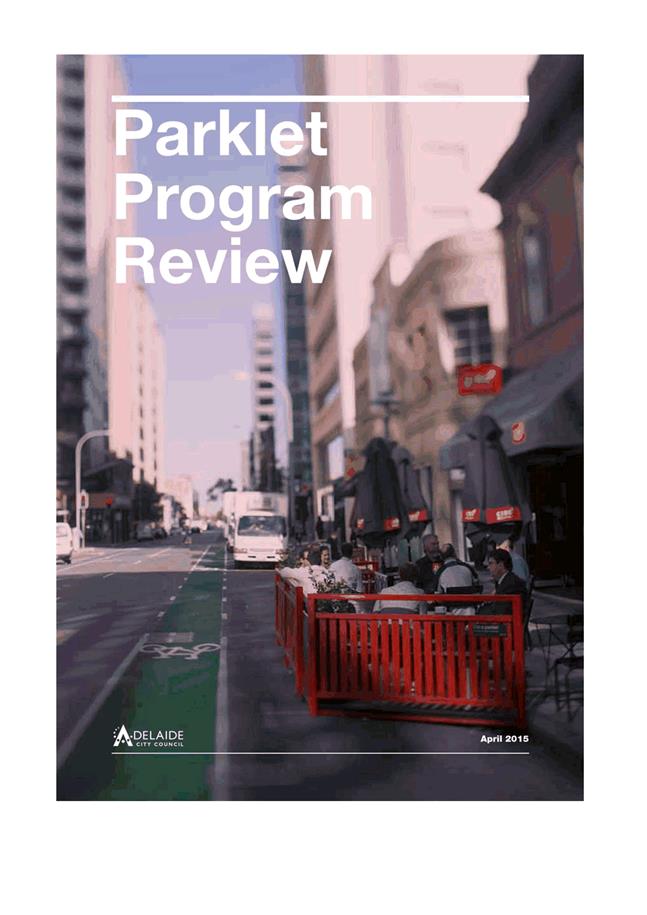
6.4 Development of a Parklet Policy - Response to Notice of Motion
File Ref: F17/58628; 35-1-1
Memorandum of the Manager Traffic Engineering and the Director City Infrastructure of 16 June 2017 and attachments.
Delegation: Council
|
Item No. 6.4 |
Agenda (Open Portion) City Infrastructure Committee Meeting |
Page 85 |
|
|
21/6/2017 |
|

Memorandum: City Infrastructure Committee
Development of a Parklet Policy - Response to Notice of Motion
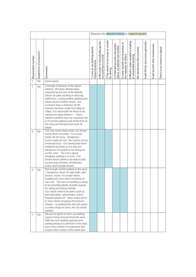
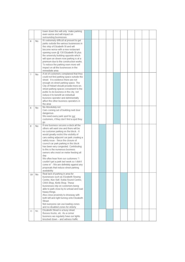
The purpose of this memorandum is to provide additional information relevant to some discussion points raised at the Council’s 5 June meeting. The relevant report was initially on the agenda of the City Infrastructure Committee Meeting of 24 May 2017, and is included as Attachment A.
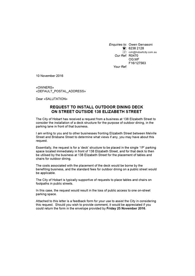
Impacts on car parking
The parklet will require 2 car parking spaces for its installation. One space is required for the deck itself, and a portion of a second space will be used for bollards and a wheel stop to reduce the risk of a car bumping the deck while manoeuvring into the adjacent parking space. The bollards would only use about a third of a car parking space, so there would be opportunity to include motor bike parking or bicycle parking in the remainder of the second space.
The current provision of on-street parking in Elizabeth Street, between Melville and Brisbane Streets, is:
South side:
· 8 x metered 1P spaces
· 12 x metre weekday loading zone
· 2 x unmetered 15 minute weekend spaces (at the Brisbane Street end, outside Arts Tasmania)
North side, prior to and after UTAS development
· 10 x metered 1P spaces
· 1 x 5 minute space outside 163 Elizabeth Street
North side, current temporary arrangement until UTAS construction is complete
· 5 x metered 1P spaces
UTAS advises that the development is expected to be complete in mid-July. At that time, 6 on-street car parking spaces in Elizabeth Street (and 4 in Melville Street) will be once again available for the public to use.
100 new off-street City of Hobart public car parking spaces will be available within the UTAS development.
In addition to this significant provision of car parking, changes can be made to parking time controls to provide some shorter-term parking on the street. This would increase turnover and provide opportunities for loading. Consultation with the businesses at the Melville Street end of the strip (including Ken Self Cycles and Eddy’s Sewing Centre) suggest that providing some shorter term parking would benefit these businesses, which rely on customers dropping off and picking up heavy or bulky items.
Provision of public space and amenity within the UTAS development
The location and extent of the open space plazas provided by the UTAS development is illustrated in the diagram below. A private plaza for student and staff use is located to the east. A smaller plaza to the west is open to the public, accessed from Brisbane Street and Elizabeth Street.
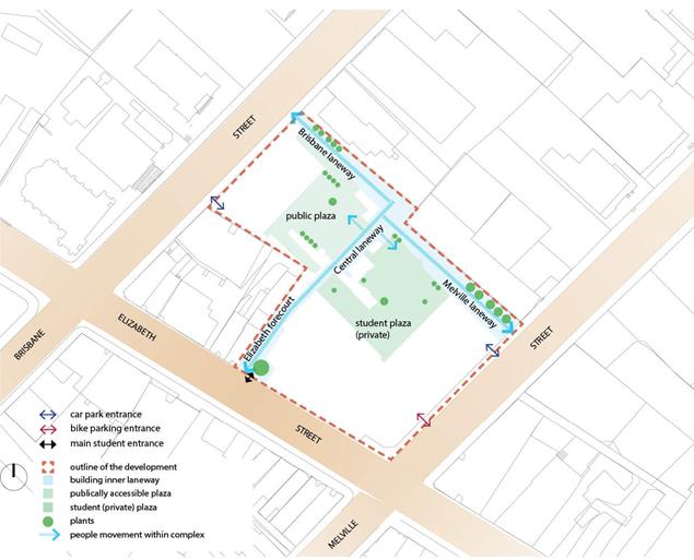
Figure 1 – UTAS development (Source: Speculate 2017 – 430@Melville)
The public plaza will be a welcome addition to the area as there is very little public open space in this part of the city.
As the plans suggest, this is a somewhat enclosed courtyard which, if well landscaped will offer respite from the busy city streets. However the space is unlikely to contribute to vibrant and active street life in the same way that a parklet would.
Public Space and amenity – public seating
The Gehl report advocates ‘a bench for resting every 100 metres’ along key pedestrian routes.
The map below shows the existing public seating in this part of the city. There is very little seating in the precinct, and no public benches at all in Elizabeth Street between Brisbane and Melville Streets.
Seating here would likely be well-patronised due to the diverse mix of shops and services in the strip and the relatively high numbers of people walking along this principal pedestrian corridor.
However the footpath is too narrow to install public seating. A parklet would provide an opportunity for public seating to be introduced. It would provide a place for people to rest and comfortably stay for a while, within the streetscape.
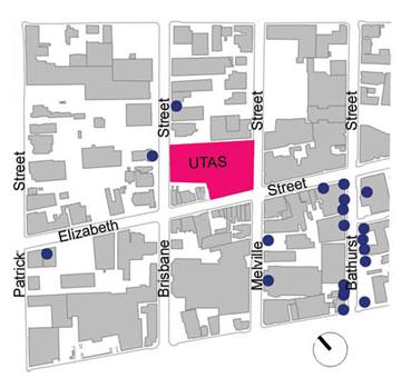
Figure 2 – location of public benches (Source: Speculate 2017 – 430@Melville)
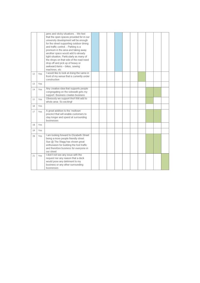
Is it ‘appropriate’ to locate a parklet in this location?
There were some concerns raised about a business (The Stagg) benefiting at the City’s expense. And a further suggestion that a parklet would be better placed in front of a retail business that was not a café to ensure fairness for businesses who currently pay for occupational licences.
The strip has a diverse mix of businesses
as can be seen in figure 3. Experiences in other places suggests that
this vibrant mix of retail, hospitality, services, arts and education uses
would make the location an excellent fit to ensure successful activation of a
parklet. 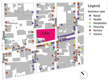
Figure 3 – Business type (Source: Speculate 2017 – 430@Melville)
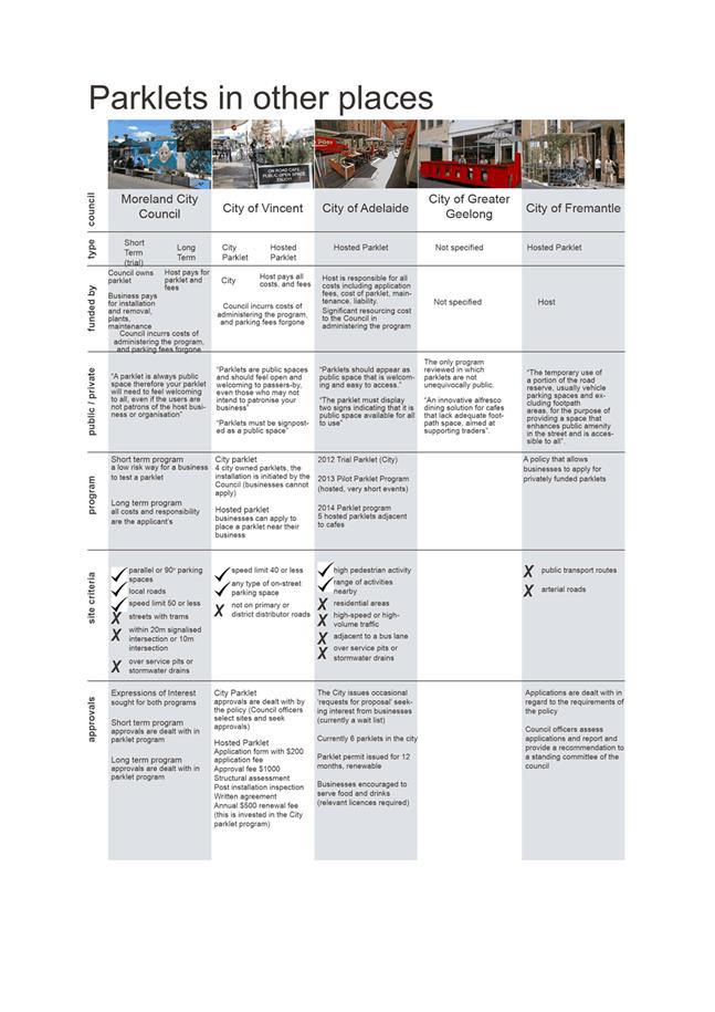
Discussions with other councils suggest that an enthusiastic café host is considered to be the ideal type of business to host a parklet. There is little doubt that such a business would benefit from a parklet, and the business would be a partner - taking on day to day maintenance during the trial period. The 6 month trial model allows a business to try a parklet prior to investing in costly infrastructure. Given that the parklet model is new for Hobart, the trial / short term option is considered important to allow it to be tested by businesses and monitored by officers as part of the development of a program and policy.
Typically with other programs:
· The Council-owned trial parklet is removed after the trial period and replaced with a longer-term installation that is fully funded by the host.
· This longer-term parklet must still be open and welcoming of the public, and would still need to satisfy the relevant design and safety criteria.
· Hosts are required to provide evidence that nearby traders are supportive of the parklet as part of their application (presumably this is easier once a trial has been conducted and any impacts tested and managed).
· A longer term, business-funded parklet is operated under an annual permit.
If the Council resolves to proceed with the proposal, the details of such a program would be developed as part of the trial.
Safety and risk
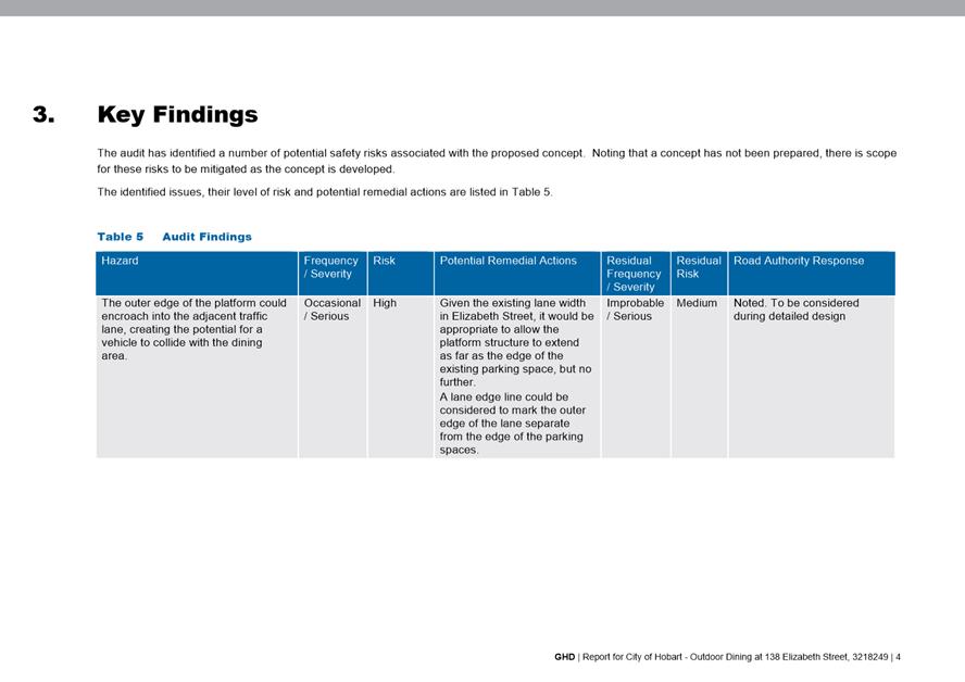
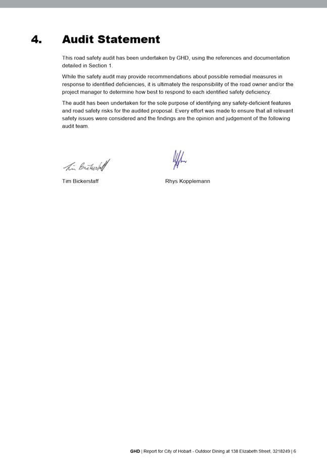
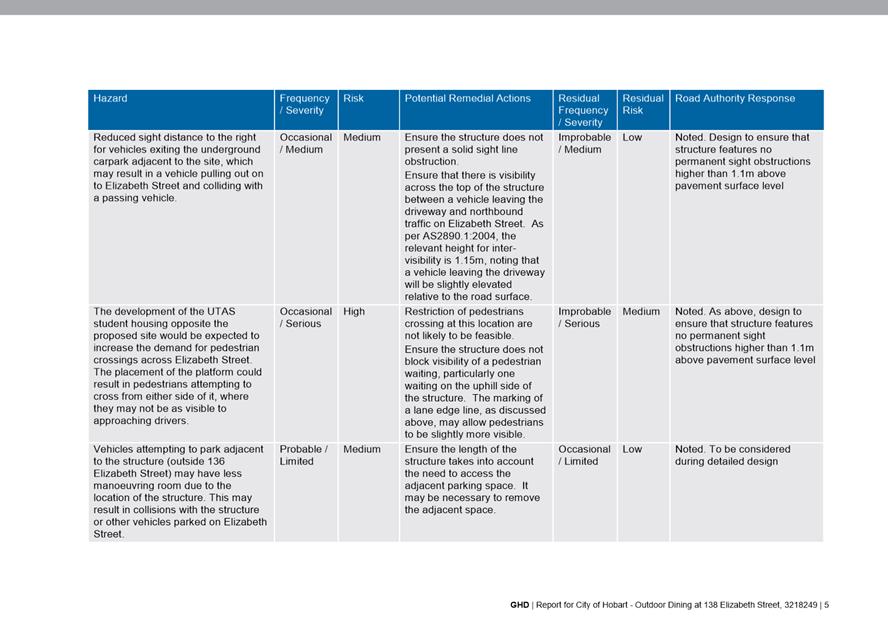
Safety and risk related to installing a parklet in the road reserve was mentioned during discussion. GHD Pty Ltd have conducted a site-specific risk review which assesses road safety of the installation and addresses the concerns raised by some traders during consultation. The consultant advises that the parklet can be provided safely. The risk review is provided as Attachment B.
|
That the recommendation contained in the attached report dated 19 May 2017 be endorsed.
|
As signatory to this report, I certify that, pursuant to Section 55(1) of the Local Government Act 1993, I hold no interest, as referred to in Section 49 of the Local Government Act 1993, in matters contained in this report.
|
Angela Moore Manager Traffic Engineering |
Mark Painter Director City Infrastructure |
Date: 16 June 2017
File Reference: F17/58628; 35-1-1
Attachment a: Previous
Report dated 19 May 2017 ⇩ ![]()
Attachment
b: Parklet
Risk Review - GHD ⇩ ![]()
|
Item No. 6.4 |
Agenda (Open Portion) City Infrastructure Committee Meeting - 21/6/2017 |
Page 90 ATTACHMENT a |

|
Agenda (Open Portion) City Infrastructure Committee Meeting - 21/6/2017 |
Page 136 ATTACHMENT b |
|
Item No. 6.4 |
Agenda (Open Portion) City Infrastructure Committee Meeting - 21/6/2017 |
Page 141 ATTACHMENT b |
|
Item No. 6.4 |
Agenda (Open Portion) City Infrastructure Committee Meeting - 21/6/2017 |
Page 144 ATTACHMENT b |
|
Agenda (Open Portion) City Infrastructure Committee Meeting |
Page 147 |
|
|
|
24/5/2017 |
|
7.1 Potential Permanent Partial Road Closure in Campbell Street, Hobart
FILE REF: F17/50530
Alderman Briscoe and Alderman Thomas
Motion
“That: 1. A report to be prepared that investigates the potential for a permanent partial road closure in Campbell Street, Hobart, between Bathurst Street and Collins Street, with a single traffic lane to remain open for emergency services vehicles, public transport and bicycle access.
2. The report to consider the following:
(a) Given the proposed development in this area, the benefits of increasing pedestrian networks and people-friendly spaces.
(b) A full traffic impact assessment and modelling on the implication of a permanent partial road closure of Campbell Street, Hobart, between Bathurst Street and Collins Street, with a single traffic lane to remain open for emergency services vehicles, public transport and bicycle access;
(c) The likely financial costs involved; and
(d) The recommended community and stakeholder consultation process.”
Rationale:
“With the significant public and private investment in and around Campbell Street it is timely that the physical conditions provided for pedestrians and issues related to walking and getting around are properly considered with any future upgrade of Campbell Street.
Cities around the world are judged and critiqued on their ‘liveability’ which has as a key criteria the encouragement of open space and amenity and the availability of pedestrian friendly zones . The Gehl report upon which much of the current and medium term $300m infrastructure spend is referenced lays emphasis on transforming Hobart from a car dependent city to one which has a range of transport modes, including pedestrian friendly facilities.
The city has recently visited Europe together with the University of Tasmania Vice Chancellor specifically looking at pedestrian friendly zones cities and towns where the University presents is both well regarded and heavily promoted.
Major developments in the area include:
- The establishment of a science, technology, engineering and mathematics hub (STEM ) on the corner of Argyle and Melville Street of which is expected to bring 3,000 students and 700 staff;
- The construction of a major ‘creative industries and performing arts development’, the Hedberg, creating a world-class entertainment precinct, which will invigorate and enliven both the Wapping precinct and the city as a whole. The new building will adjoin the Theatre Royal in Campbell Street and is due for completion early 2019;
- The Brooker Bridge, linking the Inner city from Bathurst Street, across the Brooker Avenue to the Domain;
- The redevelopment of the Royal Hobart Hospital;
- The existing TasTAFE campus on Campbell Street; and
- The existing Menzies Research Institute on the corner of Campbell Street and Liverpool Street.
Further to the significant investment and development within our city the Council must keep pace by investing, improving and modernising our roads, paths and open spaces.
The new developments will bring an increase of people to study, work and live in the city generating an unprecedented level of heavy pedestrian activity. This strengthens the pedestrian network creating opportunity to support the unique character of this area.
The Council supports the continued growth of the University of Tasmania (UTAS) campuses in the inner city. A key role in supporting growth is to provide great pedestrian environments around the city.
The recent three week closure of Campbell Street, 25 September 2016 through to 16 October 2016, similar to what is being suggested in this Notice of Motion, known as the ‘Stage 3 headwork’s’ in support of the Royal Hobart Hospital redevelopment, did not result in significant impacts in most cases as analysed in the Construction Traffic Impact Assessment Report, dated 11 November 2016, by GHD Pty Ltd.
The report indicated that the network generally continued to operate satisfactorily. This provides opportunity for the Council to further assess its options when considering the upgrade of Campbell Street and include measures that support an increase in pedestrian networks within the area.
A future pedestrian network should include a variety of street types linking the main streets and connecting important destinations, giving consideration to public spaces that are an attractive and inviting way to lead people from space to space through the city.
Currently Hobart has a weak pedestrian network. Vehicular traffic is dominating the city and has a negative effect on a number of streets and public spaces. Calming of vehicular traffic and giving a higher priority to people in transit, cyclists and pedestrians is required to create a more lively and social environment.
The report should include alternative transport routes in the area, including the availability of the adjacent Brooker Highway and also countenance the potential for a vehicle free zone [except for the emergency vehicles access cited above] which might be time linked e.g. 930 am until 4 pm and 630 pm until 930 am .
Where feasible the Council should consider the scaling down of roads and intersections to provide a human scale street environment and encourage multi-use areas for the provision of public seating possibilities, more opportunities for physical activities, strengthen the pedestrian network, encourage more opportunities for relaxing in the public spaces on a daily basis and make the city more attractive to study, work and live in..”
The General Manager reports:
“In accordance with Clause 5 of the Notices of Motion procedures, I provide the following qualification as to whether the substance of this Notice of Motion resides within the jurisdiction of the Hobart City Council:
The substance of this Notice of Motion resides within the jurisdiction of the Hobart City Council as it considers the partial closure of a local road under its control.”
|
Item No. 7.2 |
Agenda (Open Portion) City Infrastructure Committee Meeting |
Page 150 |
|
|
21/6/2017 |
|
7.2 Transferring the Control and Ownership of Davey and Macquarie Streets to the State Government
FILE REF: F17/64579; 13-1-9
Lord Mayor Alderman Sue Hickey
Motion
“That an urgent report be prepared that examines the advantages and disadvantages of the council transferring the control and ownership of Davey and Macquarie Streets to the State Government, with the report to consider potential short and long term financial implications, including advice on maintenance, asset renewal and depreciation expenses.
That the report includes advice concerning the viability and issues associated with the creation of creating bus / multi occupancy vehicle lanes on Davey and Macquarie Streets, including consideration of how a trial might be implemented.”
Rationale:
“There has been growing community concern regarding the impacts of increasing levels of traffic congestion in the City. The City of Hobart is the road authority for Davey and Macquarie Streets and for the Brooker Highway south of Burnett Street.
In addition to providing for pedestrians and a frontage to local residences and businesses, these roads link State Highways to the north, east and south of the City. The City, however, does not control the main arterials connecting to these roads or the management of traffic signals on these roads, with these being State Government responsibilities.
This motion seeks a report from Council officers on the implications of a potential transfer of these Highways from the City to the State Government.
The report should give consideration to:
· The effectiveness of the current shared management of these roads, given that the State Government owns and controls traffic signals and controls the setting of speed limited;
· The potential impact of any further bus priority and traffic congestion management measures, including the management and provision of clearways
· Accessibility to adjoining properties
· Pedestrians and other vulnerable road users
· Council's ability to improve pedestrian connections across the roads
· The coordination of roadworks and third party permit approvals
· Any relevant financial implications.”
The General Manager reports:
“In line with the Council’s policy in relation to Notices of Motion, I advise that the matter is considered to be within the jurisdiction of the Hobart City Council has responsibility for the management of these roads and suggests potential changes to help alleviate the traffic congestion within the City.”
|
Agenda (Open Portion) City Infrastructure Committee Meeting |
Page 151 |
|
|
|
21/6/2017 |
|
A report indicating the status of current decisions is attached for the information of Aldermen.
REcommendation
That the information be received and noted.
Delegation: Committee
|
Item No. 8.1 |
Agenda (Open Portion) City Infrastructure Committee Meeting - 21/6/2017 |
Page 153 ATTACHMENT a |
|
Agenda (Open Portion) City Infrastructure Committee Meeting |
Page 170 |
|
|
|
21/6/2017 |
|
Regulation 29(3) Local Government
(Meeting Procedures) Regulations 2015.
File Ref: 13-1-10
The General Manager reports:-
“In accordance with the procedures approved in respect to Questions Without Notice, the following responses to questions taken on notice are provided to the Committee for information.
The Committee is reminded that in accordance with Regulation 29(3) of the Local Government (Meeting Procedures) Regulations 2015, the Chairman is not to allow discussion or debate on either the question or the response.”
9.1 Burnett Street Pedestrian Refuge
File Ref: F17/46486; 13-1-10
Memorandum of the Director City Infrastructure of 16 June 2017.
9.2 Street Trees - Lower Jordan Hill Road, Mount Stuart
File Ref: F17/58182; 13-1-10
Memorandum of the Director City Infrastructure of 16 June 2017.
Delegation: Committee
|
That the information be received and noted.
|
|
Item No. 9.1 |
Agenda (Open Portion) City Infrastructure Committee Meeting |
Page 172 |
|
|
21/6/2017 |
|
Memorandum: Lord Mayor
Deputy Lord Mayor
Aldermen
Response to Question Without Notice
Burnett Street Pedestrian Refuge
|
Meeting: City Infrastructure Committee
|
Meeting date: 26 April 2017
|
|
Raised by: Alderman Burnet |
|
Question:
In regard to the Arthur Street pedestrian refuge closest to the Burnett Street roundabout, how often is the refuge sign replaced due to damage, and is it considered an appropriate place for pedestrians to cross?
Response:
Officers have investigated the maintenance history of the pedestrian refuge island on Arthur Street near Burnett Street, North Hobart and provide the following information:
· Maintenance records indicate that works were undertaken on the sign at this refuge in 2014. It was also noted that during an inspection held on 31 May 2017, the sign had been damaged (see photograph over). The City’s workforce were subsequently requested to put the sign back into place.
· No other records of maintenance at this location were found. Maintenance officers also advised that they were not aware that this refuge, or its signs, required any regular maintenance.
Officers have reviewed the site to determine if this location is an appropriate place for pedestrians to cross. It was noted that the refuge is located on a straight section of road which is relatively flat. The sight distances for vehicles and pedestrians were checked against the Austroads Guidelines and were appropriate for a 50 km/h speed environment.
It should be noted that there are currently no pram ramps or parking restrictions on the kerbs adjacent to this crossing point. However, kerb renewal works are programmed for this section of Arthur Street in the 2020-2021 financial year and pedestrian improvements would be considered as part of that project.
The crash history has been reviewed and there have been four crashes reported on Arthur Street (between Murray Street and Andrew Street). Of these crashes, one occurred in the vicinity of the pedestrian refuge island outside 6 Arthur Street. The crash occurred in 2006 and did not involve a collision with the island – instead it involved a vehicle pulling out from the parking spaces colliding with a vehicle travelling along Arthur Street towards the Murray Street roundabout and was a property damage only crash.
Given the absence of reported crashes and the adequate sight distances it is considered that this refuge is an appropriate place for pedestrians to cross Arthur Street.
As signatory to this report, I certify that, pursuant to Section 55(1) of the Local Government Act 1993, I hold no interest, as referred to in Section 49 of the Local Government Act 1993, in matters contained in this report.
|
Mark Painter Director City Infrastructure |
|
Date: 16 June 2017
File Reference: F17/46486; 13-1-10
|
Item No. 9.2 |
Agenda (Open Portion) City Infrastructure Committee Meeting |
Page 175 |
|
|
21/6/2017 |
|
Memorandum: Lord Mayor
Deputy Lord Mayor
Aldermen
Response to Question Without Notice
Street Trees - Lower Jordan Hill Road, Mount Stuart
|
Meeting: City Infrastructure Committee
|
Meeting date: 24 May 2017
|
|
Raised by: Alderman Reynolds |
|
Question:
Is there a proposal to remove several street trees as part of road works in Lower Jordan Hill Road, Mount Stuart?
Response:
Lower Jordan Hill Road, Mount Stuart from number 48 to Mellifont Street has been listed for road asset renewal works in the coming months. The works have been placed on the programme as the road assets at this location (road surface, footpaths and kerbs) are nearing the end of their useful life and require renewal.
Prior to the design commencing, officers contacted the local residents to ascertain what issues are currently causing them concern and how the works could incorporate modifications to the current arrangement in order to alleviate their concerns.
During initial discussions, the residents consistently identified that the existing road width does not adequately accommodate through traffic when cars are parked in the street. Residents advised they have to deal with parking issues on a daily basis. Larger and wider vehicles (such as service, delivery and removal vehicles) have difficulty using this road and residents advise some vehicles cannot use it at all.
Residents also advised that accesses are very steep and are at awkward angles. This along with cars parking opposite driveways, significantly impacts on the ability of residents to enter and exit their own properties.
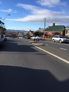
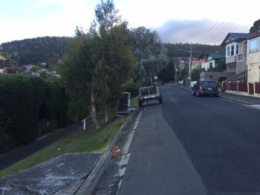
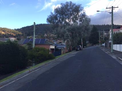
Residents noted that the absence of a footpath on the road next to the nature strip is a concern to passengers entering and exiting vehicles onto the very steep nature strip. The photos below show the street’s current arrangement.
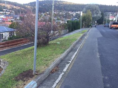
One resident advised that the large tree located on the embankment outside of his property is a Eucalyptus Morrisbyi (Morrisby’s Gum) – see photograph below. This resident has indicated he would be strongly opposed to the tree’s removal.
Taking into account all of the residents’ comments, officers have commenced drafting conceptual designs with the aim of addressing residents’ concerns where possible.
The draft concept plan includes the widening of the road to allow reasonable vehicle access and inclusion of a footpath next to the nature strip.
The large Morrisby Gum is not proposed to be removed in the draft concept plan. It is noted that its ongoing presence would result in parking losses if the road is widened. Hence, there may be some concerns from residents regarding this loss of parking.
Some other smaller trees would possibly be removed to allow the road to be widened. Discussions with staff from the Parks and City Amenity Division have indicated they are not concerned with this proposal.
Officers will consult with residents again to obtain their feedback on the concept plan prior to the design being finalised. Any issues that cannot be adequately resolved may be the subject of a future report to the City Infrastructure Committee.
As signatory to this report, I certify that, pursuant to Section 55(1) of the Local Government Act 1993, I hold no interest, as referred to in Section 49 of the Local Government Act 1993, in matters contained in this report.
|
Mark Painter Director City Infrastructure |
|
Date: 16 June 2017
File Reference: F17/58182; 13-1-10
|
|
Agenda (Open Portion) City Infrastructure Committee Meeting |
Page 178 |
|
|
21/6/2017 |
|
Section 29 of the Local Government (Meeting Procedures) Regulations 2015.
File Ref: 13-1-10
An Alderman may ask a question without notice of the Chairman, another Alderman, the General Manager or the General Manager’s representative, in line with the following procedures:
1. The Chairman will refuse to accept a question without notice if it does not relate to the Terms of Reference of the Council committee at which it is asked.
2. In putting a question without notice, an Alderman must not:
(i) offer an argument or opinion; or
(ii) draw any inferences or make any imputations – except so far as may be necessary to explain the question.
3. The Chairman must not permit any debate of a question without notice or its answer.
4. The Chairman, Aldermen, General Manager or General Manager’s representative who is asked a question may decline to answer the question, if in the opinion of the respondent it is considered inappropriate due to its being unclear, insulting or improper.
5. The Chairman may require a question to be put in writing.
6. Where a question without notice is asked and answered at a meeting, both the question and the response will be recorded in the minutes of that meeting.
7. Where a response is not able to be provided at the meeting, the question will be taken on notice and
(i) the minutes of the meeting at which the question is asked will record the question and the fact that it has been taken on notice.
(ii) a written response will be provided to all Aldermen, at the appropriate time.
(iii) upon the answer to the question being circulated to Aldermen, both the question and the answer will be listed on the agenda for the next available ordinary meeting of the committee at which it was asked, where it will be listed for noting purposes only.
|
|
Agenda (Open Portion) City Infrastructure Committee Meeting |
Page 179 |
|
|
21/6/2017 |
|