City
of hobart
AGENDA
City Infrastructure Committee Meeting
Open Portion
Wednesday, 26 April 2017
at 5.00 pm
Lady Osborne Room, Town Hall
City
of hobart
AGENDA
City Infrastructure Committee Meeting
Open Portion
Wednesday, 26 April 2017
at 5.00 pm
Lady Osborne Room, Town Hall
THE MISSION
Our mission is to ensure good governance of our capital City.
THE VALUES
The Council is:
|
about people |
We value people – our community, our customers and colleagues. |
|
professional |
We take pride in our work. |
|
enterprising |
We look for ways to create value. |
|
responsive |
We’re accessible and focused on service. |
|
inclusive |
We respect diversity in people and ideas. |
|
making a difference |
We recognise that everything we do shapes Hobart’s future. |
|
|
Agenda (Open Portion) City Infrastructure Committee Meeting |
Page 3 |
|
|
26/4/2017 |
|
Business listed on the agenda is to be conducted in the order in which it is set out, unless the committee by simple majority determines otherwise.
APOLOGIES AND LEAVE OF ABSENCE
1. Co-Option of a Committee Member in the event of a vacancy
3. Consideration of Supplementary Items
4. Indications of Pecuniary and Conflicts of Interest
6.1 Response to Petition on Increased Traffic Volumes on Summerhill Road, West Hobart
6.2 Lenah Valley Retail Precinct Streetscape Upgrade
6.3 Conference Reporting - Bike Futures Conference - 9 March 2017.
6.4 South Hobart Pedestrian Improvements
7 Committee Action Status Report
7.1 Committee Actions - Status Report
8. Responses to Questions Without Notice
8.1 Drainage in Marieville Esplanade Car Park
10. Closed Portion Of The Meeting
|
|
Agenda (Open Portion) City Infrastructure Committee Meeting |
Page 5 |
|
|
26/4/2017 |
|
City Infrastructure Committee Meeting (Open Portion) held Wednesday, 26 April 2017 at 5.00 pm in the Lady Osborne Room, Town Hall.
|
COMMITTEE MEMBERS Burnet (Chairman) Deputy Lord Mayor Christie Denison Reynolds Harvey
ALDERMEN Lord Mayor Hickey Zucco Briscoe Ruzicka Sexton Cocker Thomas |
Apologies:
Leave of Absence: Nil.
|
|
The minutes of the Open Portion of the City Infrastructure Committee meeting held on Wednesday, 29 March 2017, are submitted for confirming as an accurate record.
|
Ref: Part 2, Regulation 8(6) of the Local Government (Meeting Procedures) Regulations 2015.
|
That the Committee resolve to deal with any supplementary items not appearing on the agenda, as reported by the General Manager.
|
Ref: Part 2, Regulation 8(7) of the Local Government (Meeting Procedures) Regulations 2015.
Aldermen are requested to indicate where they may have any pecuniary or conflict of interest in respect to any matter appearing on the agenda, or any supplementary item to the agenda, which the committee has resolved to deal with.
Regulation 15 of the Local Government (Meeting Procedures) Regulations 2015.
A committee may close a part of a meeting to the public where a matter to be discussed falls within 15(2) of the above regulations.
In the event that the committee transfer an item to the closed portion, the reasons for doing so should be stated.
Are there any items which should be transferred from this agenda to the closed portion of the agenda, or from the closed to the open portion of the agenda?
|
Agenda (Open Portion) City Infrastructure Committee Meeting |
Page 6 |
|
|
|
26/4/2017 |
|
6.1 Response to Petition on Increased Traffic Volumes on Summerhill Road, West Hobart
File Ref: F17/22483
Report of the Manager Traffic Engineering and the Director Infrastruture Services of 20 April 2017 and attachments.
Delegation: Council
|
Item No. 6.1 |
Agenda (Open Portion) City Infrastructure Committee Meeting |
Page 8 |
|
|
26/4/2017 |
|
REPORT TITLE: Response to Petition on Increased Traffic Volumes on Summerhill Road, West Hobart
REPORT PROVIDED BY: Manager Traffic Engineering
Director City Infrastructure
1. Report Purpose and Community Benefit
1.1. This report is provided in response to a petition tabled at the Council meeting held on 21 November 2016 regarding Summerhill Road, West Hobart.
2. Report Summary
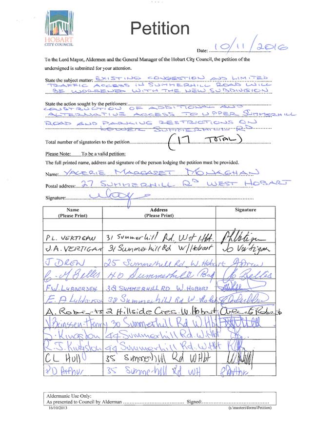
2.1. The petition, with 17 signatories (copy included as Attachment A to this report), requested that the Council give consideration to additional and alternative access to upper Summerhill Road, West Hobart, due to the existing traffic congestion and limited access which may be worsened with development planned for the area.
2.2. Subsequent to the receipt of this petition an application was submitted on 23 December 2016 to subdivide the 10.4 hectare title of 66 Summerhill Road. The application proposes to create 10 general residential lots (9 lots plus balance), one environmental management zoned lot plus the road reservation. This application is currently invalid and on hold awaiting further information to be provided by the development, including the preparation of a traffic impact statement.
2.3. The planning assessment process is considered the most appropriate avenue for addressing the residents’ concerns regarding the impacts of increased traffic on Summerhill Road, West Hobart.
2.4. Traffic surveys have been completed in Summerhill Road and this data, along with crash data, has been reviewed and no significant issues have been identified relating to road safety, traffic capacity or residential amenity.
2.5. No further action is proposed in relation to this petition.
|
That: 1. Matters raised in the petition relating to increased traffic volumes in Summerhill Road be considered during the planning assessment of the proposed subdivision of land at 66 Summerhill Road, West Hobart. 2. The petitioners be notified of the Council’s decision. |
4. Background
4.1. A petition with 17 signatories (refer Attachment A to this report) was presented to the Council at its meeting held on 21 November 2016. The petition requested that the Council consider construction of additional and alternative access to upper Summerhill Road and parking restrictions on lower Summerhill Road. It is understood that the petition was prompted by a proposal to subdivide land at 66 Summerhill Road, West Hobart.
4.2. Subsequent to the receipt of this petition an application was submitted on 23 December 2016 to subdivide the 10.4 hectare title of 66 Summerhill Road. The application proposes to create 10 general residential lots (9 lots plus balance), one environmental management zoned lot plus the road reservation. This application is currently invalid and on hold awaiting further information to be provided by the development, including the preparation of a traffic impact statement.
4.2.1. The traffic impact statement is to make reference to the suitability of the existing Summerhill Road for intensification of use, including vehicle passing.
4.3. On 9 January 2017 the Manager Traffic Engineering met with the petitioner plus other residents on-site to discuss the concerns raised in the petition. The residents highlighted a number of issues including:
(i) That upper Summerhill Road was built by the residents during the 1950’s.
(ii) Concerns regarding the increased traffic that has resulted from the development of Bimbadeen Court and the likely impacts from traffic generated by an additional 50 lots being developed at 66 Summerhill Road.
(iii) Concerns around existing traffic congestion on Summerhill Road which seems to have increased since the removal of the bus stops on Summerhill Road that provided space for vehicles to pass in regular locations along the street.
4.4. A number of these matters were clarified including the quantum of the lots proposed as part of the subdivision application at 66 Summerhill Road. However, it was agreed that some traffic survey data would be obtained to inform the assessment of congestion, parking and the impacts from increased traffic volumes and that these surveys could not be completed until February 2017 once students had returned to school.
4.5. Traffic surveys were completed in both upper and lower Summerhill Road during February 2017 and are summarised as follows:
4.5.1. Between 14 February and 21 February 2017, a traffic survey was completed in upper Summerhill Road (between the two Hillside Crescent junctions) and the average weekday traffic volume was recorded as 199 vehicle/day, with weekday peak hour traffic volumes of 18 vehicle/hour (morning) and 21 vehicle/hour (afternoon). 85%ile speed was recorded as 50 km/hour.
4.5.2. Between 21 February and 28 February 2017, a traffic survey was completed in lower Summerhill Road (between Hillside Crescent and Rupara Avenue), and the average weekday traffic volume was recorded as 924 vehicle/day, with weekday peak hour traffic volumes of 126 vehicle/hour (morning) and 90 vehicle/hour (afternoon). 85%ile speed was recorded as 50 km/hour.
4.6. This traffic survey data has also been provided to the traffic engineering consultant engaged by the developer of 66 Summerhill Road to undertake the traffic impact assessment for the proposed subdivision.
4.7. In the last five years there have been three property damage only crashes reported on Summerhill Road. One crash was reported in each block of Summerhill Road (one between the Hillside Crescent junctions, one between Hillside Crescent and Rupara Avenue, and one between Rupara Avenue and Mellifont Street). None of the reported crashes appear to be related to vehicles failing to give way to each other when passing within the street.
5. Proposal and Implementation
5.1. A review of the crash history and the recently collected traffic data does not highlight any significant concerns in relation to road safety, traffic operation or the residential amenity of Summerhill Road, West Hobart.
5.2. An assessment of the likely trip generation and resultant impacts on the road network associated with the proposed subdivision of land at 66 Summerhill Road will be undertaken by the developer. This Traffic Impact Assessment report would inform the assessment of the planning application and would form the basis of any permit conditions (if the application was deemed appropriate). This could include the implementation of on-street car parking restrictions to assist vehicles to pass each other in the street.
5.3. It is considered that the planning application assessment process is the appropriate time to evaluate and address the residents’ concerns in relation to increased traffic volumes in Summerhill Road.
6. Strategic Planning and Policy Considerations
6.1. Assessing and addressing the impacts of proposed development on existing residents is included in the Council’s Capital City Strategic Plan 2015-2025 through Goal 2 – Urban Management.
6.2. In particular, reference is made to its support through Strategic Objective 2.3 and its underpinning strategies, that is:
“2.3 City and regional planning ensures quality design, meets community needs and maintains residential amenity.
2.3.1 Implement relevant planning schemes.”
7. Financial Implications
7.1. Funding Source and Impact on Current Year Operating Result
7.1.1. No works are proposed.
7.2. Impact on Future Years’ Financial Result
7.2.1. Not applicable.
7.3. Asset Related Implications
7.3.1. Not applicable.
8. Community and Stakeholder Engagement
8.1. The Manager Traffic Engineering met with the petitioner plus other residents on-site to discuss the concerns raised in the petition.
9. Delegation
9.1. This is a matter for the Council to determine.
As signatory to this report, I certify that, pursuant to Section 55(1) of the Local Government Act 1993, I hold no interest, as referred to in Section 49 of the Local Government Act 1993, in matters contained in this report.
|
Angela Moore Manager Traffic Engineering |
Mark Painter Director City Infrastructure |
Date: 20 April 2017
File Reference: F17/22483
Attachment a: Petition
- Traffic Congestion and Limited Access on Summerhill Road ⇩ ![]()
|
Item No. 6.1 |
Agenda (Open Portion) City Infrastructure Committee Meeting - 26/4/2017 |
Page 11 ATTACHMENT a |
|
Agenda (Open Portion) City Infrastructure Committee Meeting |
Page 12 |
|
|
|
26/4/2017 |
|
6.2 Lenah Valley Retail Precinct Streetscape Upgrade
File Ref: F17/31876; 2016-0189-02
Report of the Manager Traffic Engineering and the Director Infrastruture Services of 20 April 2017 and attachments.
Delegation: Council
|
Item No. 6.2 |
Agenda (Open Portion) City Infrastructure Committee Meeting |
Page 14 |
|
|
26/4/2017 |
|
REPORT TITLE: Lenah Valley Retail Precinct Streetscape Upgrade
REPORT PROVIDED BY: Manager Traffic Engineering
Director City Infrastructure
1. Report Purpose and Community Benefit
1.1. The purpose of this report is to:
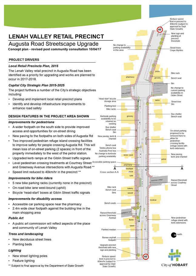
(i) Present the developed concept design and results of community engagement for the Lenah Valley Retail Precinct streetscape upgrade project.
(ii) Seek the Council’s approval to implement the project in general accordance with the concept design.
1.2. The proposed streetscape upgrade will benefit the community by:
(i) Enhancing pedestrian accessibility and safety, with particular benefits for older people and people with mobility challenges.
(ii) Supporting social life in the community by providing spaces that are more attractive and comfortable for people to stay, rest and interact.
(iii) Providing an improved environment for local traders to do business.
(iv) Supporting the Lenah Valley community in making active transport choices with improved infrastructure for walking, cycling and public transport.
2. Report Summary
2.1. At its meeting held on 21 December 2015 the Council considered a report regarding the development of “A Plan for Hobart’s Local Retail Precincts”. The Council resolved that a report be provided once detailed design and community and trader engagement had occurred in 2016 with a view to the works being completed in 2017/2018.
2.2. In response to that resolution, the streetscape design has been developed in close collaboration with a community-based Project Action Team comprising members who live, work and shop in the precinct, and community association representatives.
2.3. Broader community engagement was undertaken during February 2017. The community engagement report is contained in Attachment B to this report.
|
That: 1. The Lenah Valley Retail Precinct streetscape be upgraded, generally in accordance with the concept plans shown in Attachment A to this report, at an approximate cost of $2 million, as allocated in the 2017-2018 capital works program, subject to approval of the funding in the 2017-2018 budget. 2. Stakeholders be advised of the Council’s decision.
|
4. Background
4.1. At its meeting held on 21 December 2015 the Council resolved the following:
“That: 1. The Council endorse “A Plan for Hobart’s Local Retail Precincts”, marked as attachment A to item 10 of the Open City Infrastructure Committee agenda, as the framework basis for developing the City’s significant local retail precincts.
2. Detailed design work be undertaken for the Lenah Valley retail precinct based on the concept design provided in “A Plan for Hobart’s Local Retail Precincts”, and a further report be provided once detailed design and community and trader engagement has been completed in 2016, with a view to the works being completed in 2017/2018.
3. Detailed design work be undertaken for improved pedestrian crossing facilities in South Hobart in line with the concepts described in “A Plan for Hobart’s Local Retail Precincts” with a view to works being undertaken in 2016/2017.
4. An implementation plan based on “A Plan for Hobart’s Local Retail Precincts” and the decisions of the Council in relation to this matter be provided to the traders and other stakeholders who participated in the development of the Plan.”
4.2. South Hobart Pedestrian Improvements project is being progressed in line with point 3 of Council’s resolution, and a separate report will be provided to the Council.
4.3. In line with point 4 of Council’s resolution, the implementation plan was developed as part of the Council’s ten year capital works program. The staged program of capital upgrades to retail precincts is as follows:
(i) South Hobart pedestrian crossing improvements to occur in 2016/2017 with a budget of $350,000. This project is in development and the subject of separate report.
(ii) Lenah Valley Retail Precinct Upgrade to occur in 2017/2018 with a budget of $2 million (the subject of this report).
(iii) New Town Retail Precinct Upgrade to occur in 2018/2019 with a budget of $2 million. Initial steps towards project planning and stakeholder engagement for this project have begun.
(iv) Elizabeth Street Retail Precinct Upgrade to occur in 2019/2020 with a budget of $2.5 million. Some stakeholder engagement has begun with traders in the ‘midtown’ area, with the development of the UTAS Melville Street apartments.
(v) South Hobart Retail Precinct Upgrade to occur in 2020/2021 with a budget of $2 million.
(vi) Battery Point Retail Precinct Upgrade to occur in 2021/2022 with a budget of $1.75 million.
4.4. This report responds to clause 2 of the Council’s resolution. Community engagement has been undertaken for the Lenah Valley Retail Precinct streetscape upgrade, and the results of the engagement have informed the design.
4.5. The proposed streetscape design is included as Attachment A and the community engagement report is contained in Attachment B to this report.
5. Proposal
5.1. It is proposed that the Lenah Valley Retail Precinct be upgraded in general accordance with the concept plans at Attachment A, with works commencing in or around October 2017 and completed in the 2017/2018 financial year.
5.2. The design is broadly based on the concept outlined in “A Plan for Hobart’s Local Retail Precincts” (the Consultant Plan).
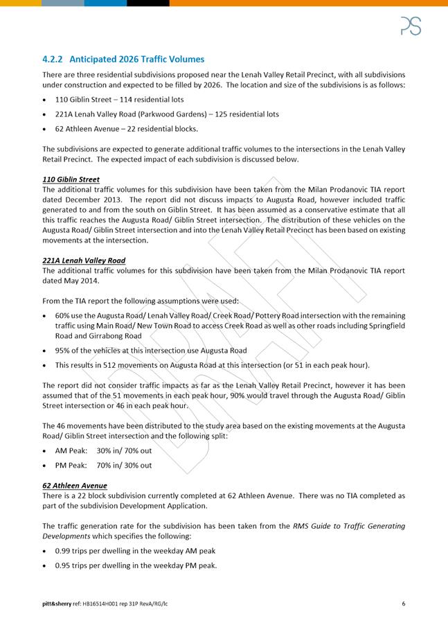
5.3. Additional planning work has been undertaken to inform the current proposal including:
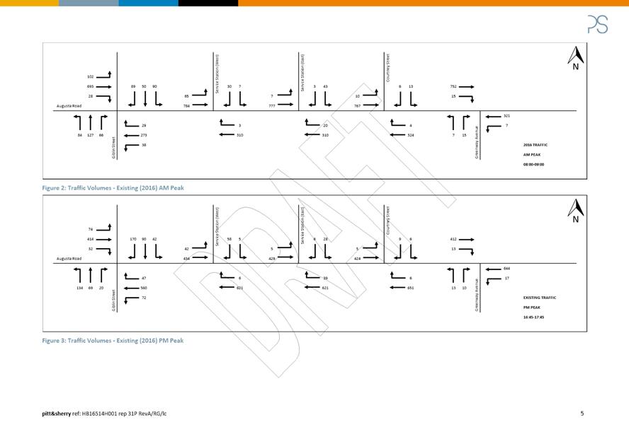
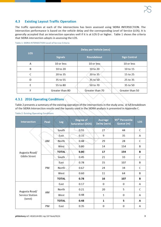
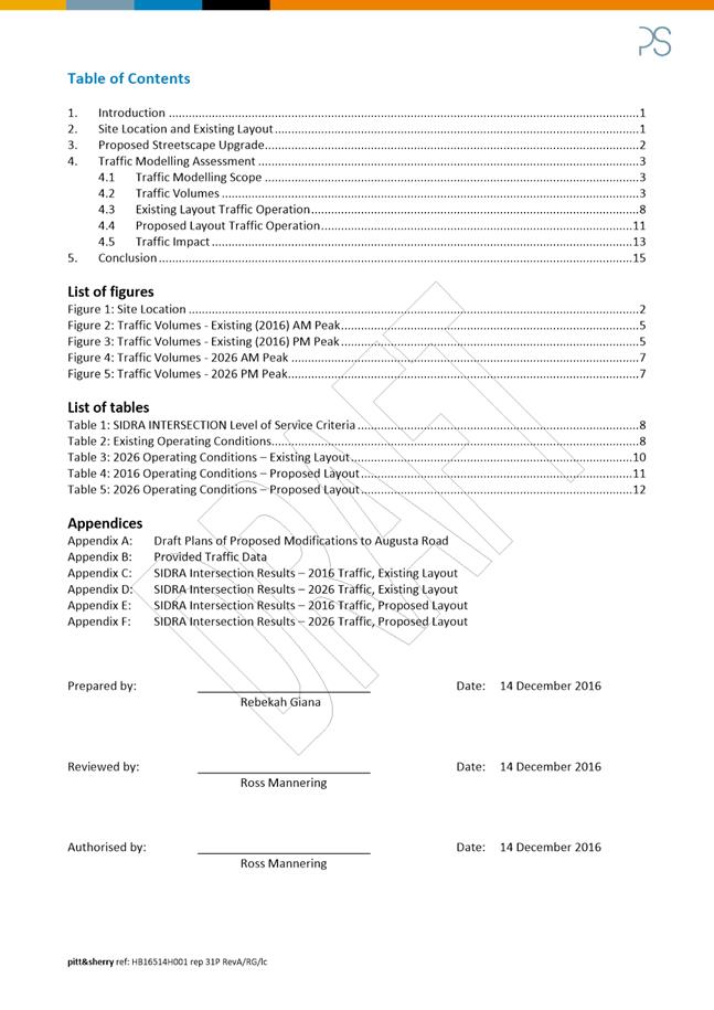
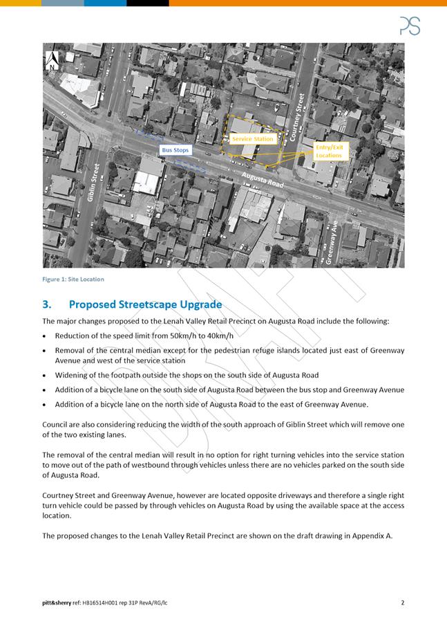
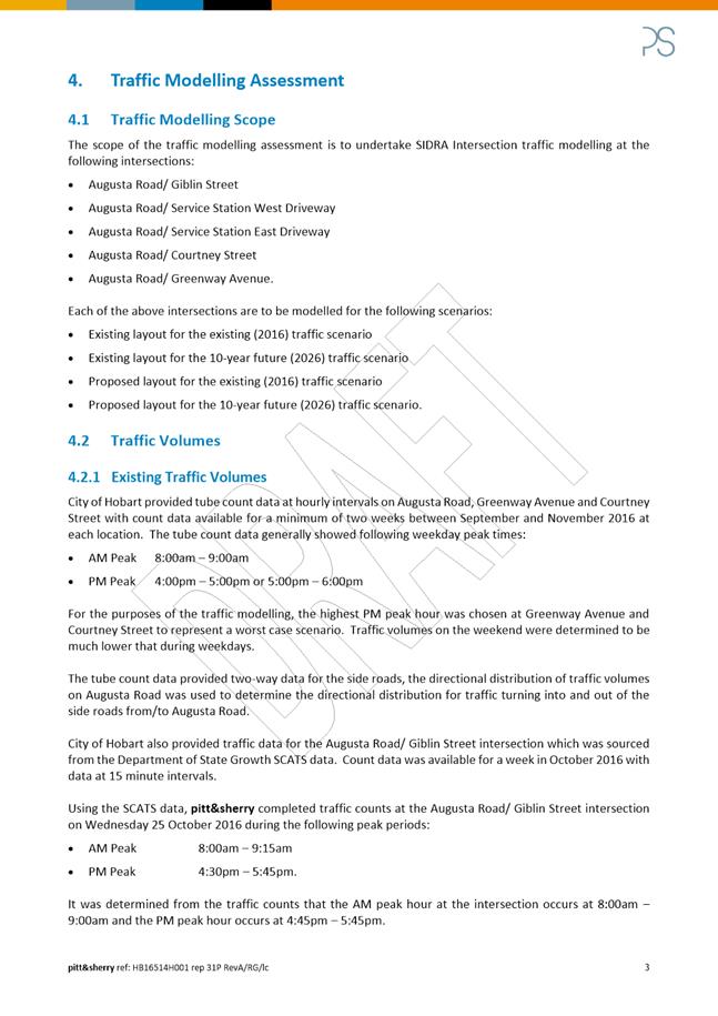
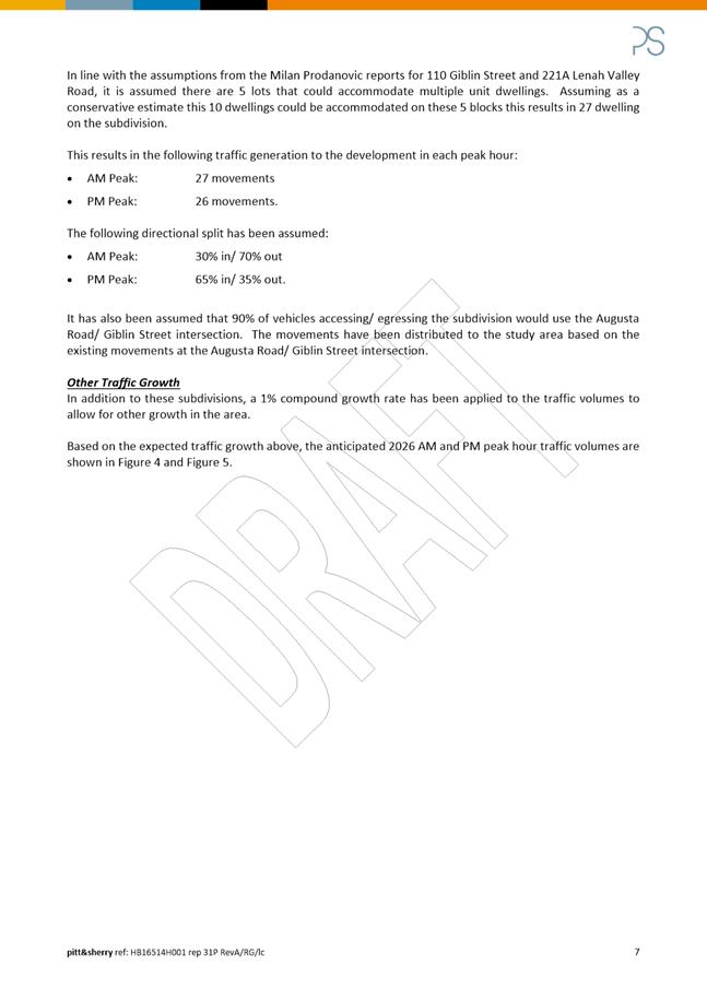
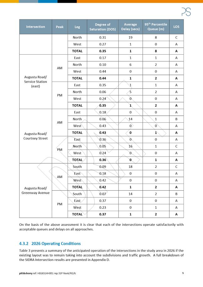
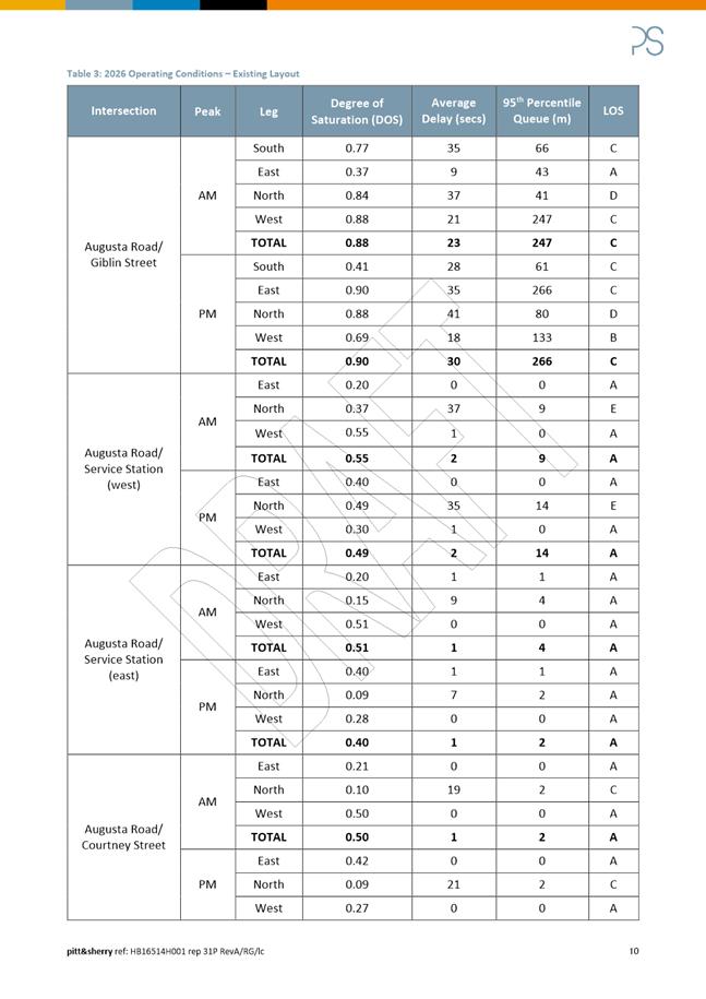
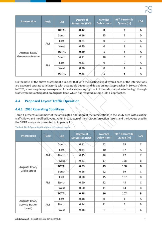
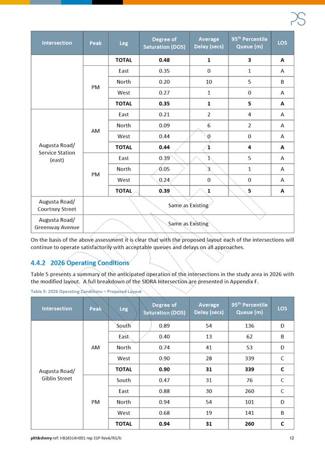
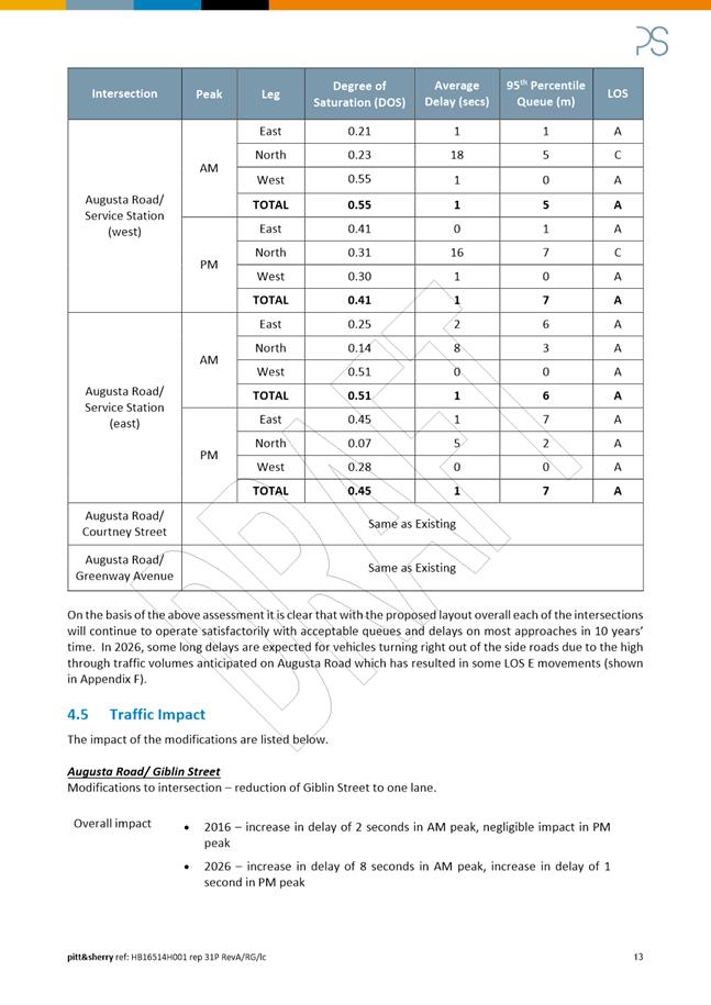
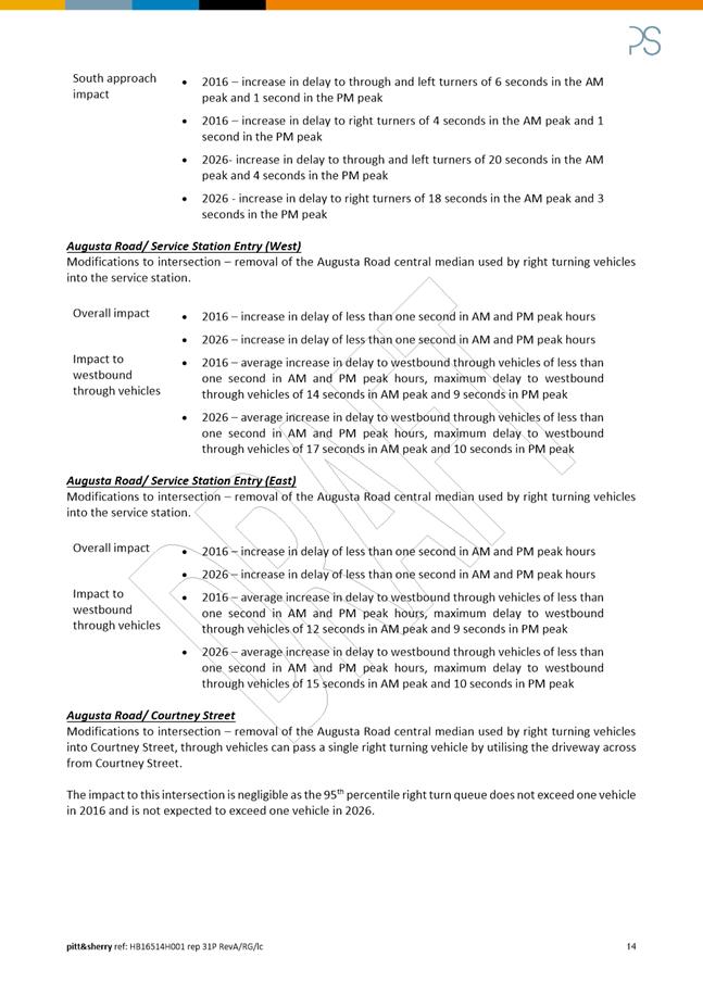
(i) Traffic counts and traffic modelling – a consultant report was provided by Pitt and Sherry (included in Attachment C to this report);
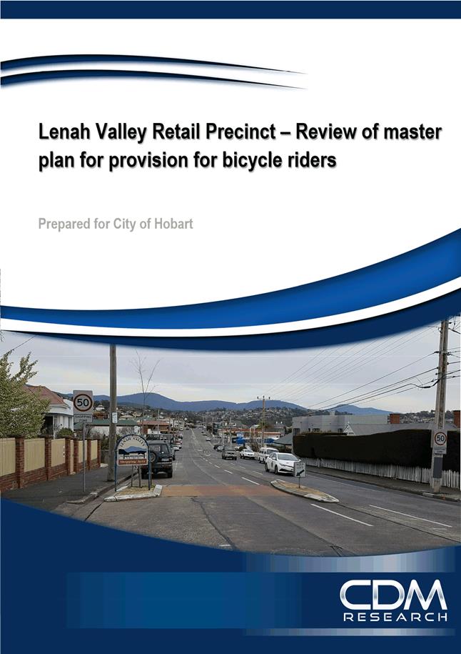
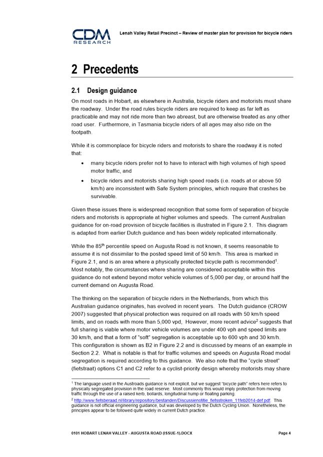
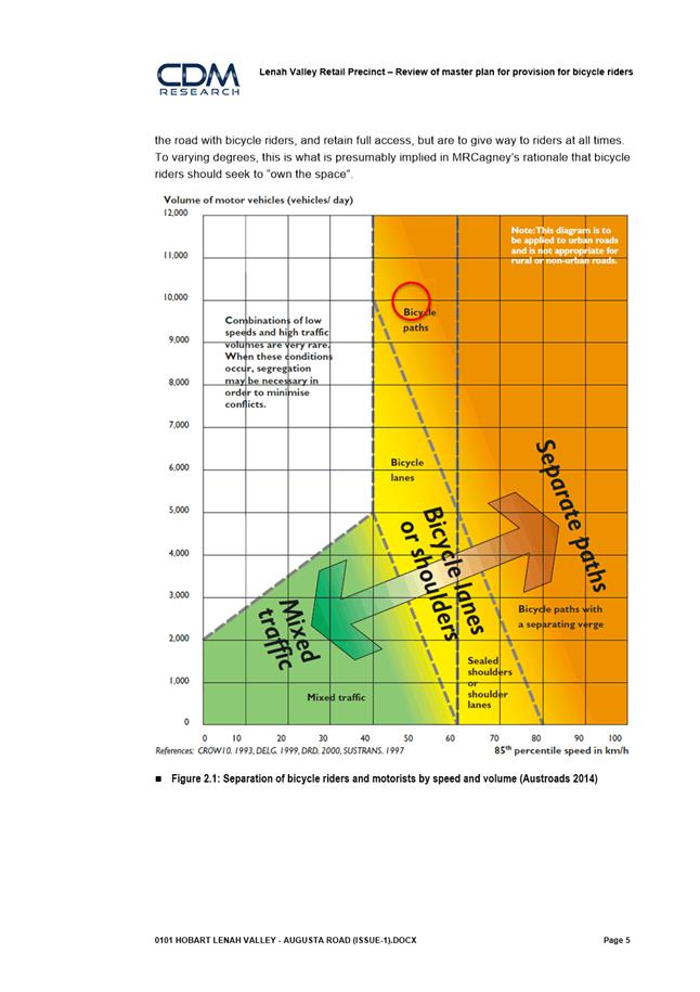
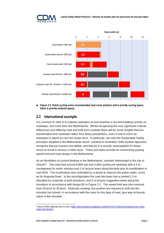
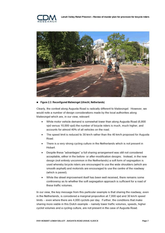
(ii) Review of provision for bicycle riders – a consultant report was provided by CDM Research (included in Attachment D to this report);
(iii) Car parking study; and
(iv) Detailed survey including underground services locations.
5.4. The additional planning work has informed a number of changes that have been made to the Consultant’s concept plan. The key changes and the rationales for these changes are listed below:
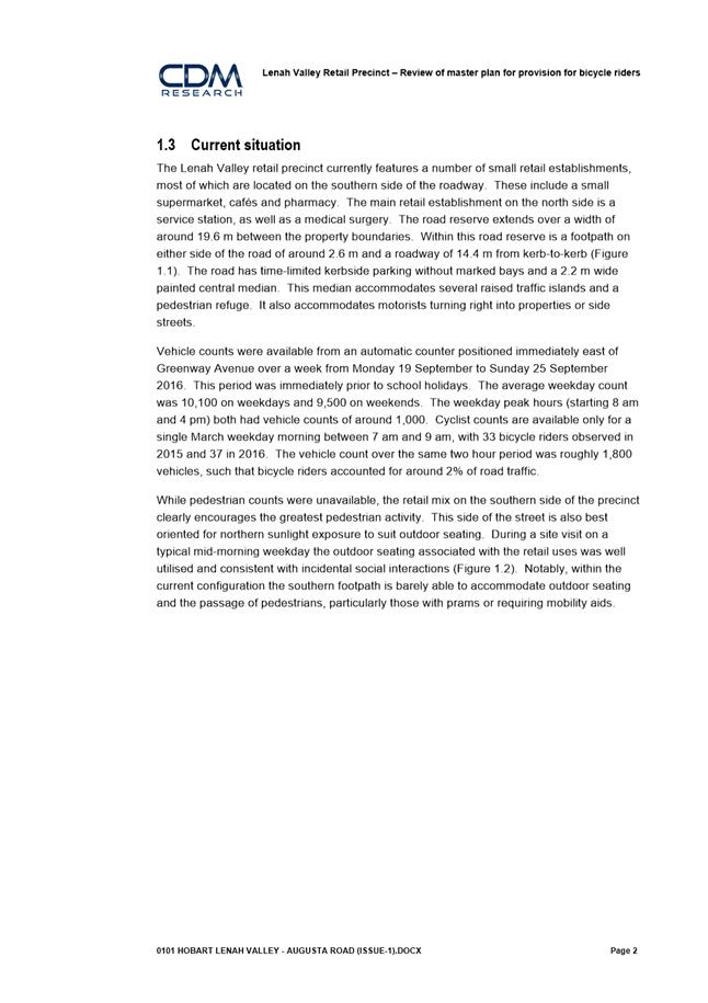
(i) Change 1: Expansion of the project scope area to include the shops immediately to the west of Giblin Street: the grocer, pizza shop and pharmacy.
Rationale: The Consultant Plan didn’t include Augusta Road businesses west of Giblin Street but it is clear that these shops are part of the retail precinct. This was agreed by the Project Action Team.
(ii) Change 2: The two bus stops are proposed to remain in their existing locations and two new bus shelters will be provided.
Rationale: There are currently bus stops in the precinct for both inbound and outbound services, however the Consultant Plan did not include the inbound (city-bound) bus stop, nor did it suggest an alternative site for it. Retail precincts are considered to be priority locations for bus stops as they provide access to shops and services for people using public transport.
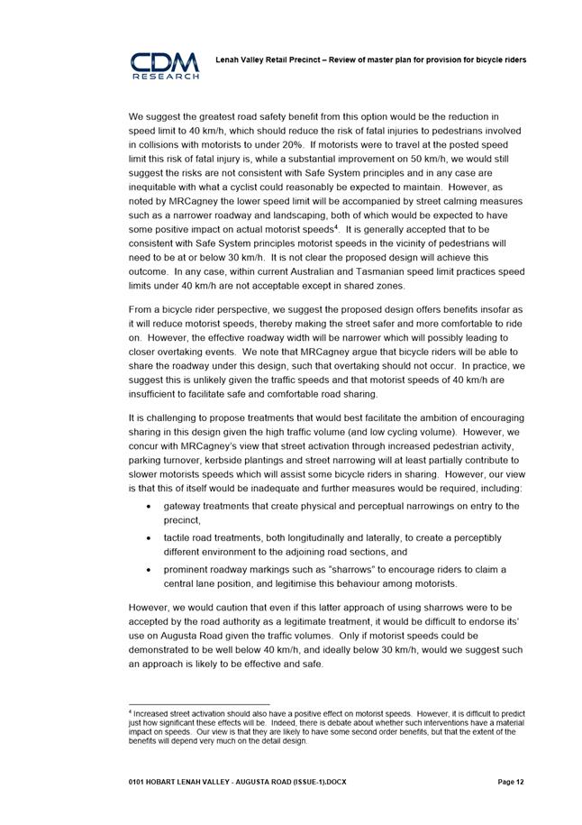
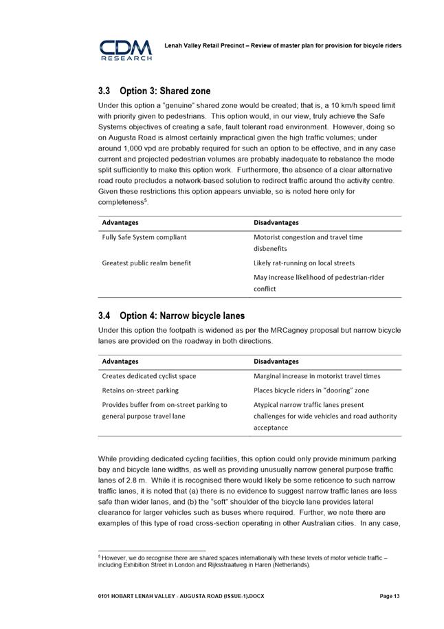
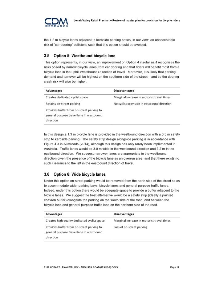
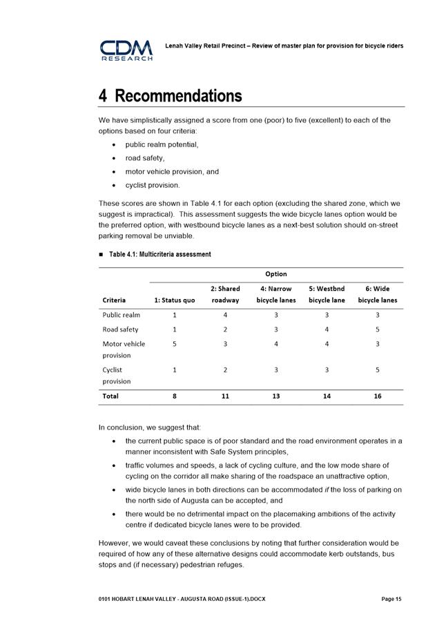
(iii) Change 3: The proposal includes an uphill bicycle lane (westward) and bicycle ‘head start’ boxes at the Giblin Street intersection.
Rationale:
· The Consultant Plan did not include provision for bicycle riders but rather recommended that cyclists ‘take the lane’ within the precinct.
· The gradient of Augusta Road means that taking the lane is not a realistic option for many bike riders due to the difference in speed between a vehicle and a bicycle going uphill.
· Augusta Road is on the Council’s endorsed Principal Bicycle Network and as such, new or replacement infrastructure should include provision for bicycles.
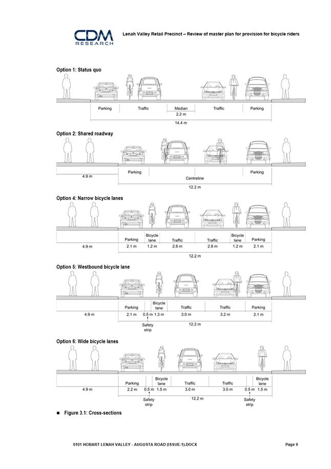
· A review of the Consultant Plan was provided by bicycle transport consultants CDM Research. Several options were considered and the uphill lane option is considered to strike the best balance between providing for motor vehicles, bicycles and pedestrians.
· The Hobart Bicycle Advisory Committee was consulted and reports to be satisfied with the proposal.
(iv) Change 4: The Consultant Plan shows trees and extensive kerb bulbing on the northern side of the road. The revised concept proposes that the northern side kerb line remains in generally the same location, and street trees will be mostly limited to the south side.
Rationale: The locations of underground services were unlikely to have been investigated by the initial consultant team. The location of a gas main on the northern side limits the scope for significant excavation, such as would be needed for tree planting, kerb relocations or substantial footings.
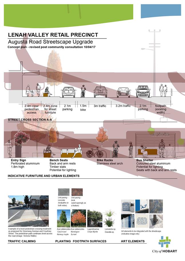
5.5. The revised concept includes the following key features:
(i) Two pedestrian crossing facilities to assist people crossing Augusta Road. These will include pedestrian refuges and kerb extensions.
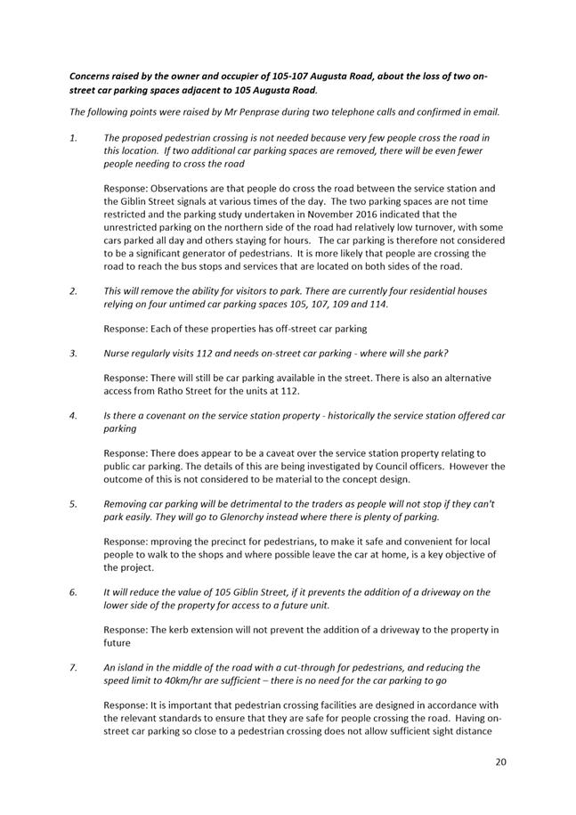
(a) Two on street car parking spaces adjacent to 105 Augusta Road will need to be removed to make way for one of these pedestrian crossing facilities.
(ii) A continuous, step-free footpath treatment at the intersections of Greenway Avenue and Courtney Street where they meet with Augusta Road.
(a) These treatments are classified as ‘road humps’ and require the approval of the State Government’s Transport Commissioner.
(b) The road humps have been advertised in accordance with statutory requirements and no representations were received.
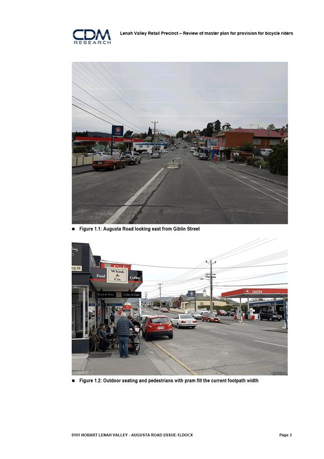
(iii) Footpath widening on the south side of Augusta Road to improve access and allow space for outdoor dining.
(iv) The existing central median lane has been removed in order to provide the additional space required to widen the footpath.
(v) New paving surfaces, renewed kerb and channel to both sides of the street.
(vi) An accessible car parking space for people with a disability in the centre of the precinct.
(vii) New street trees and low-height landscaping.
(viii) Rain garden to be installed as a trial site for Water Sensitive Urban Design in urban streetscapes.
(ix) New furniture including public seating, rubbish bins and bicycle racks.
(x) Two new bus shelters.
(xi) Improved lighting.
(xii) Precinct signage and upgraded precinct threshold treatments.
(xiii) Public art that will be integrated with the streetscape.
(xiv) A bicycle lane in the uphill direction and bicycle head start boxes at the intersection of Augusta Road and Giblin Street.
(xv) A reduction in vehicle speed limit from 50km/hour to 40km/hour within the precinct (subject to the approval of the State Government’s Transport Commissioner).
Public Art
5.6. The Public Art program commissioned an artist team to develop a concept for an artwork as an integrated part of the Lenah Valley Retail Precinct Upgrade with the following objective:
(i) To contribute to the revitalisation of the Lenah Valley Retail Precinct Upgrade, through inclusion of integrated, changing and engaging urban elements that appeal to a wide range of community members, including children, and remain contemporary and relevant for the long term.
5.7. The brief for the artwork established the following requirements:
(i) Be integrated: the rejuvenation will include a range of changes to the road, paths, lighting, street furniture and street planting. Elements of the public art response can be integrated with this work.
(ii) Incorporate the capacity for change: this area will be occupied by a changing community group over a long period of time, with some residents experiencing it on a daily or weekly basis for decades. The public art can contribute to creating a dynamic space by incorporating the capacity for change.
(iii) Provide opportunities for urban play: As an area for regular use by families, the refurbishment of this precinct offers the opportunity to incorporate urban elements that are playful and engaging for all ages, but particularly children.
5.8. The artist team was commissioned using the following process:
(i) Expressions of interest were advertised nationally.
(ii) 11 submissions were assessed for shortlisting.
(iii) Four submissions were shortlisted by a panel including the Public Art Advisory Panel; the design team; the Public Art Program team and several members of the Project Action Team (PAT) drawn from the local community.
(iv) Each of the shortlisted artists/artist teams were paid a fee to develop a concept for the work.
(v) The four concepts were presented, in person, to the same panel for selection of the artist or artist team.
5.9. The artist team selected was Alex Miles and Tony Bacic from Tasmania.
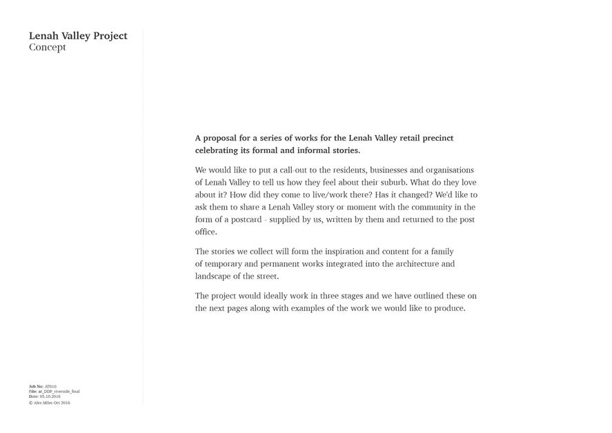
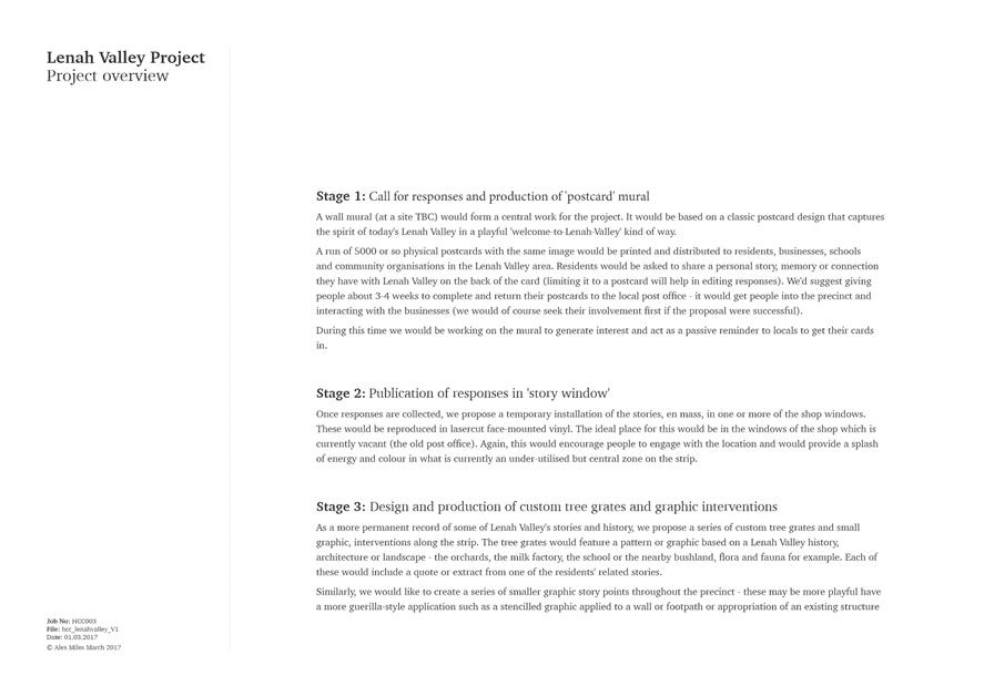
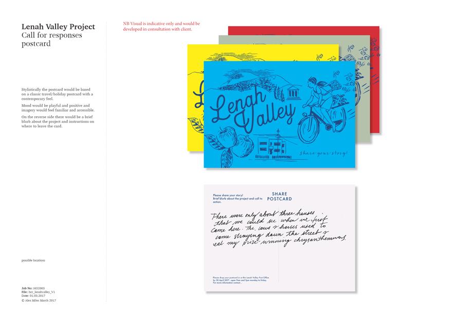
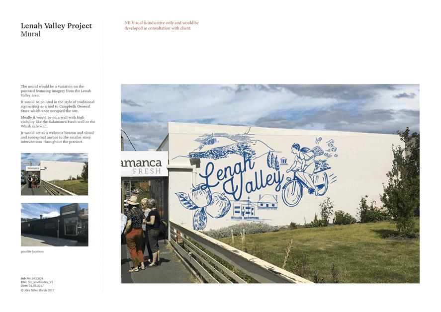
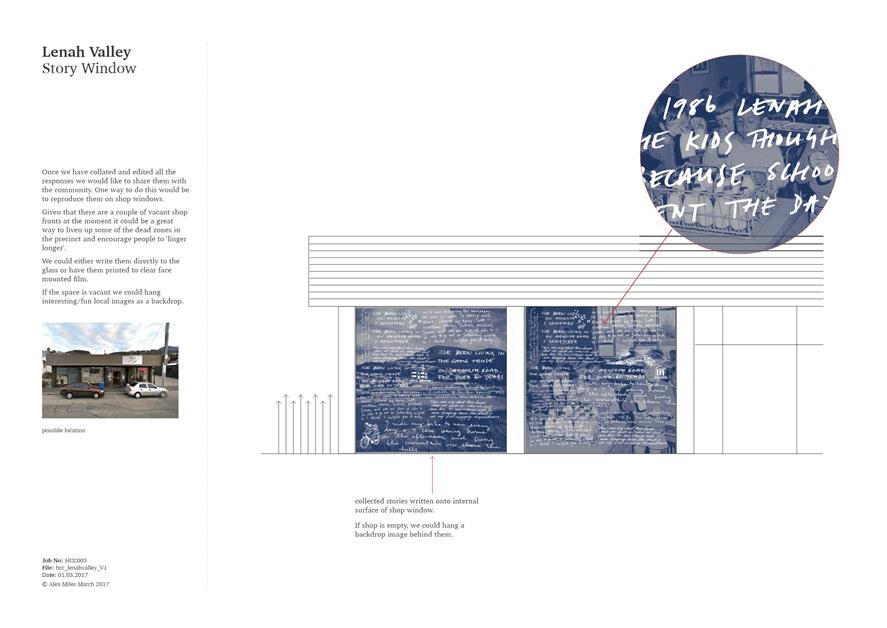
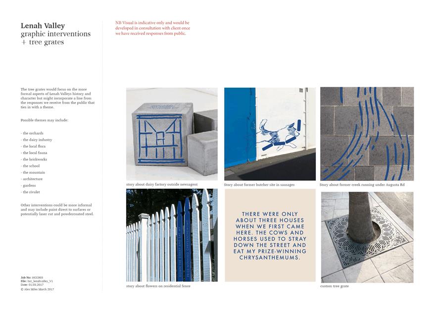
5.10. The concept for the selected artwork, as shown in Attachment E, proposes using a strong identifying colour, an illustrative graphic style and a series of collected stories from local residents, to establish a strong visual and story-based identity for the retail precinct.
5.11. The artist team will now develop the design, fabricate and install the work in coordination with the overall construction project.
5.12. The detail of the final artwork is being resolved in collaboration with the design team and is likely to include some or all of the following:
(i) A mural to the side of an existing property, in the selected artwork colour (likely blue).
(ii) A series of small graphic elements throughout the area on walls and fences (e.g an image of a dog running away with a string of sausages, on the side wall of the old butcher shop).
(iii) A series of interventions into new infrastructure for the street including seating and bus shelters that use the colour, collected stories, or illustrations.
(iv) A series of small scale and artful elements in the street, which might include additional playful seating for children, tree grates indicating water movement and Water Sensitive Urban Design Initiatives, or objects to be illuminated at night.
6. Implementation
6.1. Should the Council resolve to proceed with the project there are several activities that need to be undertaken prior to construction of the works commencing. These include:
(i) Finalise detail design and documentation of the works.
(ii) Approval to be sought from the Transport Commissioner for the raised hump / continuous footpath treatments across Greenway Avenue and Courtney Street where these streets meet Augusta Road. The advertising and consultation that is required for the formal approval process under Section 31 of the Local Government (Highways) Act 1982, has already been undertaken and no representations were received.
(iii) Approval to be sought from the Transport Commissioner for the reduction of vehicle speed limit in the precinct from 50km/hour to 40km/hour, to take effect after the completion of the works.
6.2. The project is scheduled to commence in the fourth quarter of 2017, to be substantially complete by the end of June 2018.
6.3. It is anticipated that the first stage of works will be the north side of Augusta Road (the service station side).
7. Strategic Planning and Policy Considerations
7.1. Implementing a streetscape upgrade in the Lenah Valley Retail Precinct brings together a number of strategic objectives from the Capital City Strategic Plan 2015-2025, namely:
1.3.3 Develop and implement local retail precinct plans.
1.5.3 Investigate and implement a broad range of public art projects.
2.1.3 Identify and implement infrastructure improvements to enhance road safety.
2.1.5 Identify and implement measures to support the use of public transport.
2.1.6 Implement the Principal Bicycle Network.
2.2.1 Provide a wide range of quality places where the community can enjoy urban activities and events.
2.2.2 Develop, manage and maintain the city’s urban spaces and infrastructure.
7.2. The project furthers intentions and objectives of the following strategic documents:
(i) Equal Access Strategy;
(ii) Public Art Strategy; and
(iii) Stormwater Strategy 2012-2017.
8. Financial Implications
8.1. Funding Source and Impact on Current Year Operating Result
(i) The works proposed in the Lenah Valley Retail Precinct Streetscape Upgrade have been estimated to cost in the order of $2 million.
(ii) $2 million has been allocated for the project in the 2017-2018 capital works program.
8.2. Impact on Future Years’ Financial Result
(i) The works are expected to be completed within 2017-2018 and therefore no impact on future years’ financial results are anticipated.
8.3. Asset Related Implications
(i) Based on the addition of new furniture and lighting assets, future annual depreciation is expected to increase by approximately $30,000.
(ii) Based on the expected footpath and kerb renewal works, an asset write off of $76,000 is expected to be incurred when the project is handed over.
(iii) The proposed new street trees will incur an operational cost for their establishment and ongoing maintenance.
9. Legal, Risk and Legislative Considerations
9.1. The Local Government (Highways) Act 1982 (The Act), Section 31 requires the Council to apply to the Transport Commissioner for permission to install road humps such as those proposed in Courtney Street and Greenway Avenue.
9.2. Changes to speed limits are also required to be approved by the Transport Commissioner under the Act.
10. Environmental Considerations
10.1. The Lenah Valley Retail Precinct will be a trial site for water sensitive urban design. An urban rain garden incorporating street trees and planting will be installed. The purpose of a rain garden is to slow down storm water discharge, filter the water to reduce pollutants entering the Derwent Estuary and to provide passive irrigation to the trees.
10.2. The streetscape upgrade project will support the community in making active transport choices, with improved footpaths and road crossings, bicycle infrastructure and new bus shelters.
11. Social and Customer Considerations
11.1. The project includes a range of improvements that will enhance access to shops and services for people who experience difficulties with mobility.
11.2. Wider footpaths, improved pedestrian crossing points, accessible car parking and better bus shelters and facilities will increase the opportunity for members of the public who have difficulties with mobility to participate equally socially and physically.
12. Marketing and Media
12.1. A communications plan for the project has been prepared in consultation with City Marketing.
12.2. The concept phase has made use of a number of communications channels including a Your Say page for community surveys and sharing information, e-newsletters to stakeholders, articles in City News and posts to the City’s Facebook page.
12.3. Project communications materials such as newsletters and information sheets have been designed and produced with input from the Brand and Marketing Services coordinator.
12.4. The communications plan will continue to roll out prior to and during the construction phase.
12.5. Transforming Hobart branding will be used on work site branding and signage during construction.
13. Community and Stakeholder Engagement
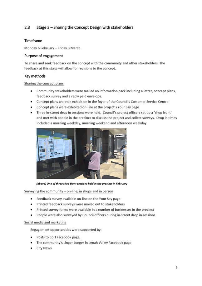
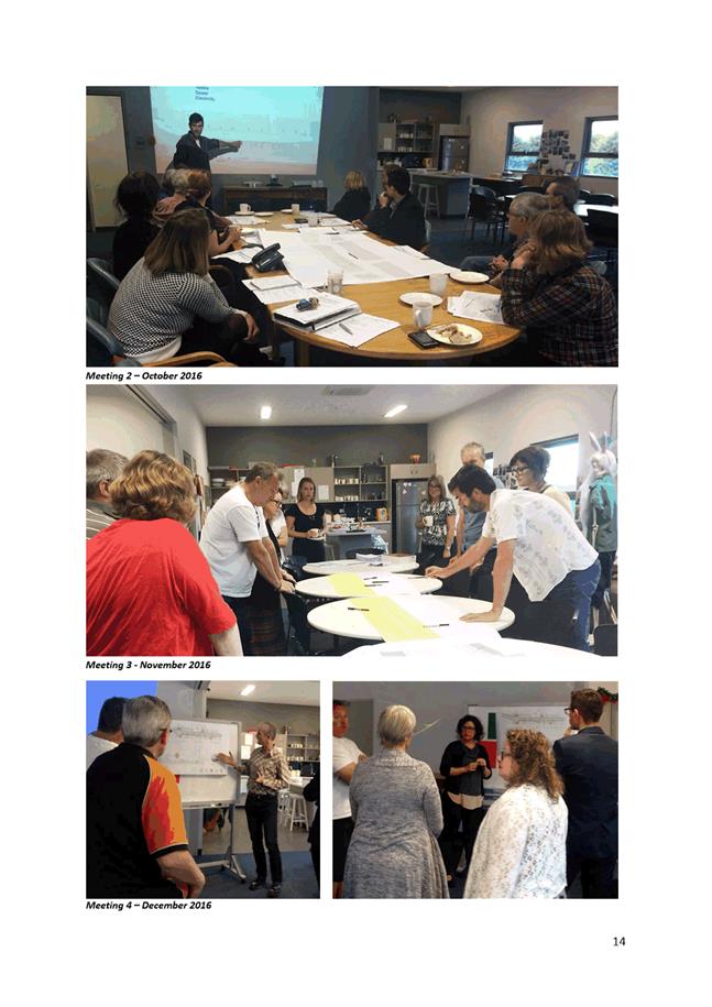
13.1. Stakeholder engagement has underpinned the development of the proposal. Key methods of engagement have included:
(i) A Project Action Team comprising traders and residents from the precinct, representatives of community organisations and the City’s project officers. The PAT has steered the concept development and will continue to meet with project delivery officers to provide a conduit between the Council and the community.
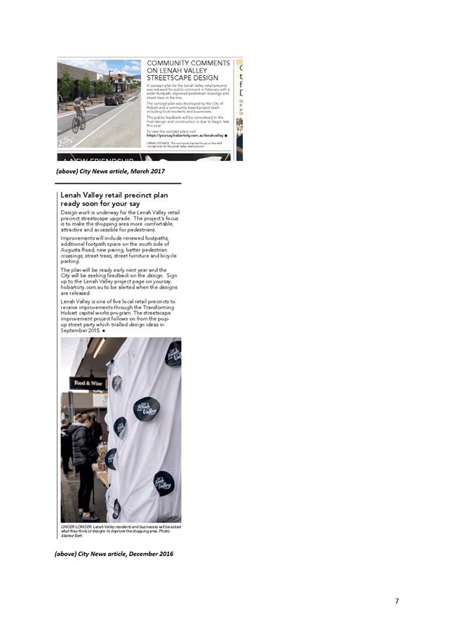
(ii) The project has an on-line presence though a number of channels including Your Say, the City’s website, the City of Hobart Facebook page and the community based Linger Longer in Lenah Valley Facebook page.
(iii) City News has published articles regarding the consultation, and updates will continue to be placed as appropriate.
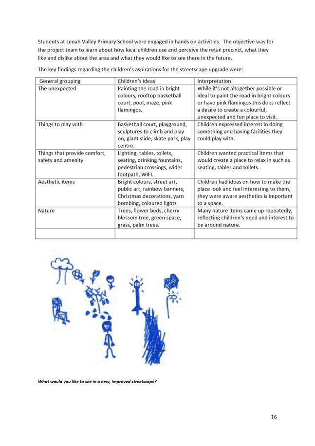
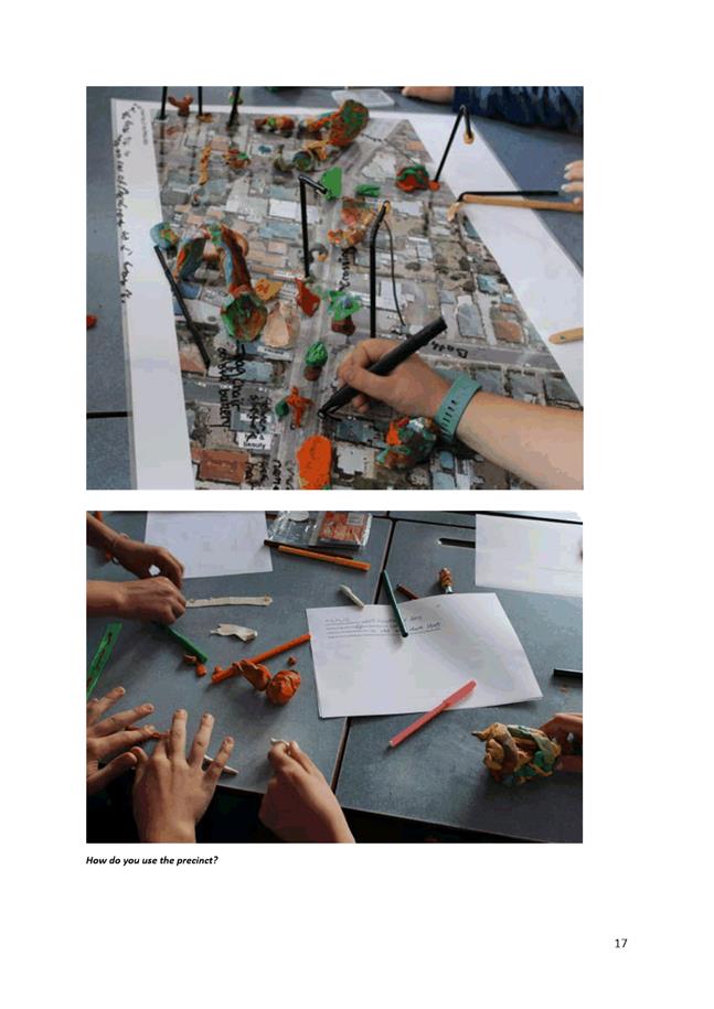
(iv) Local children have participated in engagement place-making activities.
(v) A wide range of officers from across the Council have been consulted during the development of the project from the following areas: Roads and Environmental Engineering, Design Services, City Planning, Traffic Engineering, City Marketing, Economic Development, Public Art, Community Development, Parks, Project Delivery.
(vi) Relevant service authorities have been consulted about the project including: Tas Water, Tas Networks, Metro Tasmania, Tas Gas, NBN.
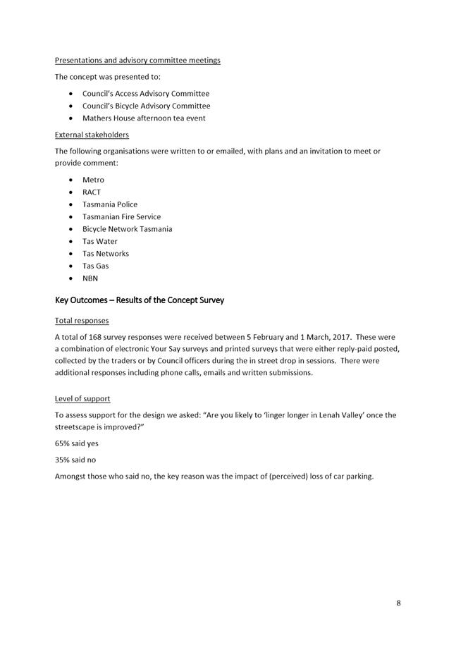
(vii) Advisory and interest groups have been consulted including: Hobart Access Advisory Committee, Hobart Bicycle Advisory Committee and Bicycle Network.
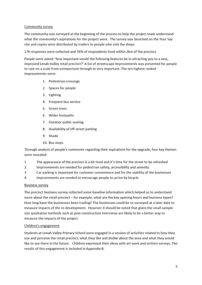
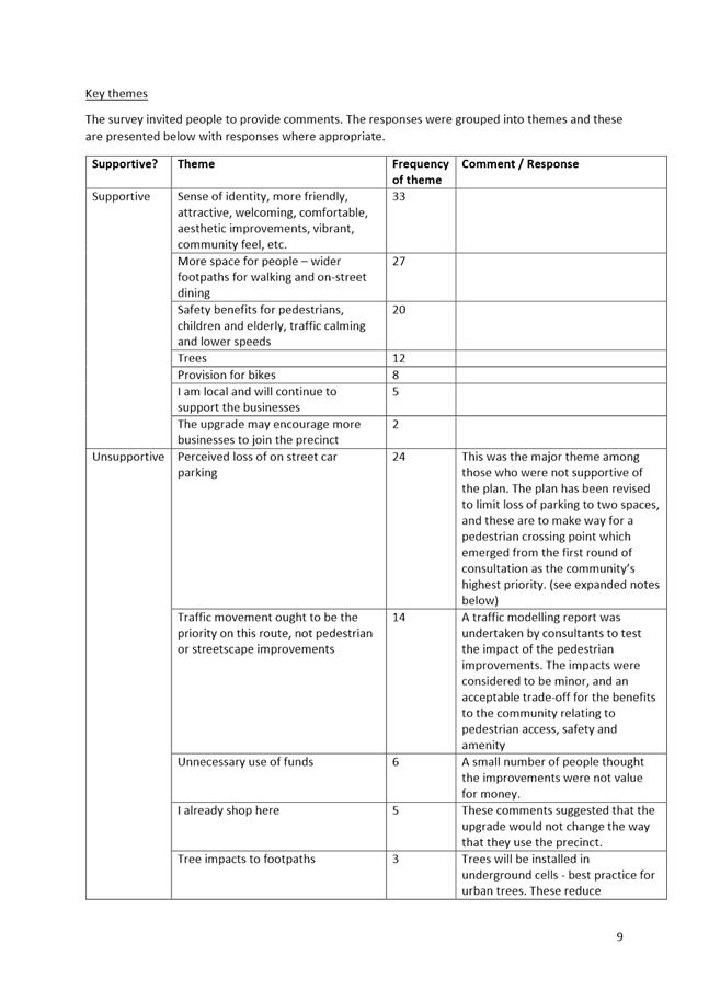
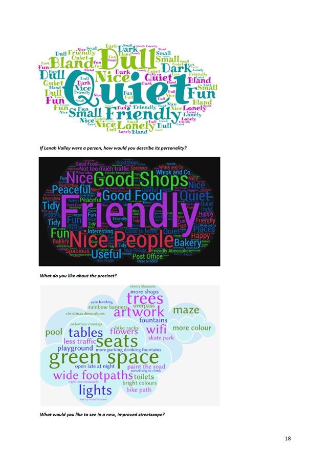
13.2. The outcomes of the community engagement are summarised as follows:
(i) 65% of community stakeholders who responded to the concept survey have indicated support for the project. Main themes emerging from the people who indicated support include:
· Improvements to the presentation and comfort of the street.
· More space for people.
· Improved safety for pedestrians, including children and older people.
· The benefits that trees will bring.
· Provision for bikes.
(ii) 35% of respondents were not in favour of the concept.
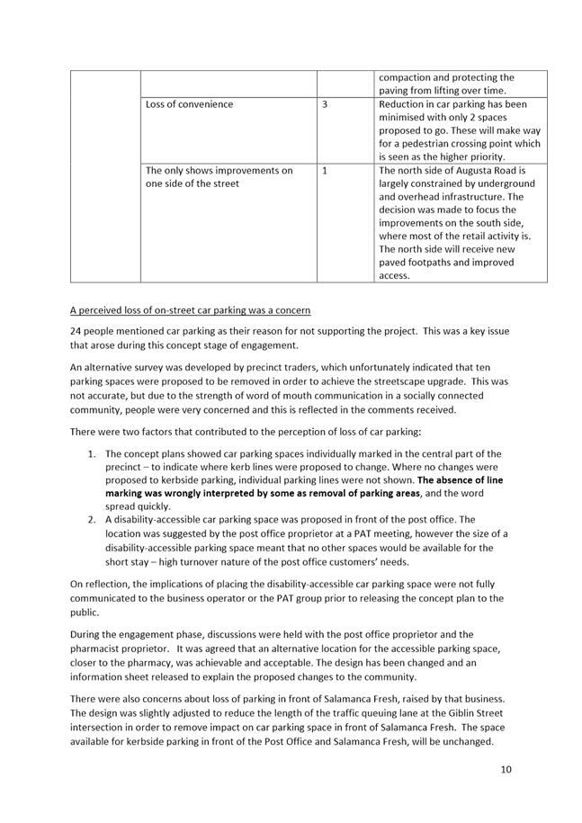
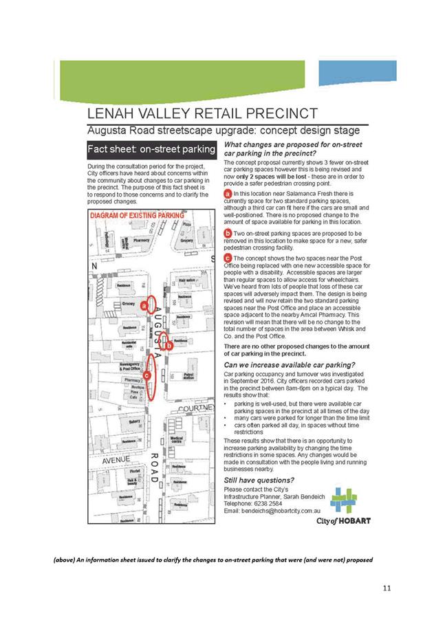
· Most of these people expressed concern about loss of on street car parking. This emerged as the biggest concern among the community during the concept engagement. For the most part, it was based on misinformation about how much car parking was proposed to be removed from the street.
· The issue was clarified and the design has been revised slightly. A total of two car parking spaces are proposed to be removed to make way for a safer pedestrian crossing point.
(iii) The Project Action Team members have all reported that they are satisfied with the revised plan, and they report that their customers and neighbours are also satisfied with the revision and clarification.
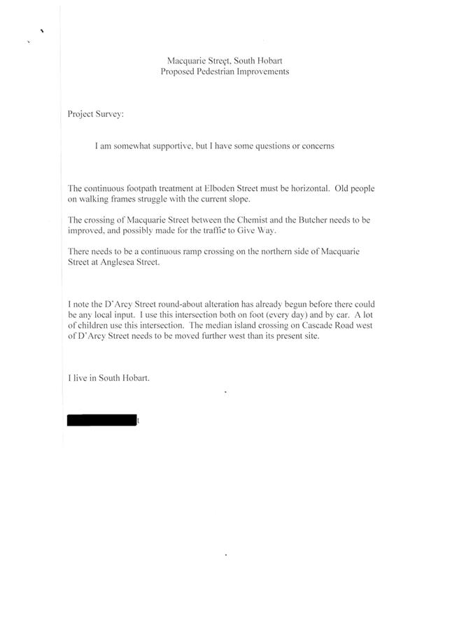
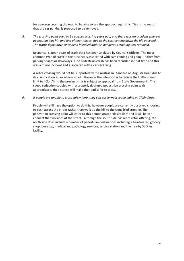
(iv) The owner and resident of 105 and 107 Augusta Road does not support the removal of on-street car parking in front of 105 Augusta Road. A list of points raised by the resident are included in the Community Engagement Report, shown as Attachment B to this report.
13.3. The key issues raised during consultation and officer responses are summarised below:
(i) Issue raised: Bicycle pinch points at pedestrian refuge crossing points.
Response: Design review has increased the lane width on the north side of the road at the location of the eastern pedestrian crossing point, to avoid creating a bicycle pinch point. Bike lanes are included where cyclists are travelling uphill. Downhill cyclists will be encouraged to ‘take the lane’.
(ii) Issue raised: Removal of the central median lane will cause traffic delays. Ensuring traffic flows should be the main priority.
Response: Traffic engineering consultants Pitt and Sherry have provided a traffic modelling report which reviews the traffic impacts of the concept. Delays to traffic caused by the removal of the central median island are expected to be minor, and an acceptable trade-off for the benefits to pedestrian amenity, safety, accessibility and amenity. The traffic modelling report is contained in Attachment C to this report.
(iii) Issue raised: Bicycle lanes should not be provided because there are so few riders.
Response: Super Tuesday bicycle count data shows a trend for growing bicycle commuter numbers in the area.
Augusta Road is part of the Council’s endorsed Principal Bicycle Network.
An options report and advice on the appropriate bicycle infrastructure for the location was provided by consultants CDM Research. This is contained in Attachment D to this report.
(iv) Issue raised: Car parking is at a premium and none should be removed.
Response: A parking study was undertaken to assess parking turnover and occupancy in the precinct as part of the development of the concept.
The results of the parking study indicate that although there are times when all parking spaces in front of the central shops are occupied, there are always opportunities within 100m.
The parking study indicated that improvements to parking availability may be achieved by time-limiting the unrestricted on street spaces on the north side of Augusta Road.
The two on-street spaces that are proposed to be removed are to allow for the installation of a pedestrian crossing facility. The community consultation showed that this was a priority for the community.
Changes to parking controls is an operational matter, and the Traffic Engineering Unit will, separately to the streetscape upgrade, investigate whether changing restrictions to parking would benefit the community.
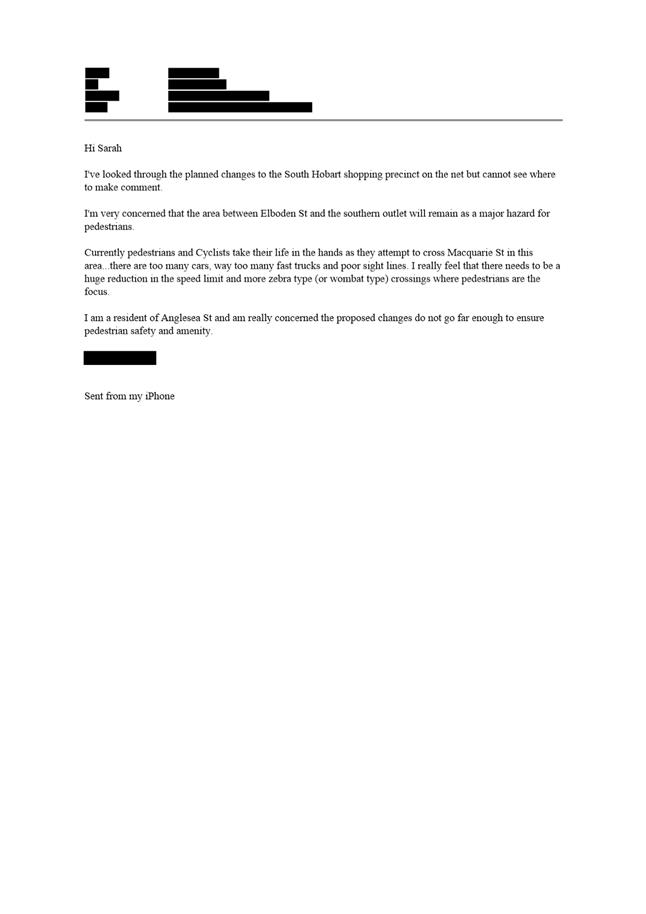
(v) Issue raised: A zebra or wombat crossing is needed across Augusta Road.
Response: The current advice from the State Government is that Australian Standards should be followed when determining the appropriate pedestrian crossing facility. Zebra and wombat crossings are not acceptable treatments on arterial roads under the Australian Standard or VicRoads guidance. Under the Tasmanian Local Government Road Hierarchy, Augusta Road is classified as an arterial road, and therefore it is not considered an appropriate site for such a crossing.
14. Delegation
14.1. This is a matter for the Council to determine.
As signatory to this report, I certify that, pursuant to Section 55(1) of the Local Government Act 1993, I hold no interest, as referred to in Section 49 of the Local Government Act 1993, in matters contained in this report.
|
Angela Moore Manager Traffic Engineering |
Mark Painter Director City Infrastructure |
Date: 20 April 2017
File Reference: F17/31876; 2016-0189-02
Attachment a: Concept
plan ⇩ ![]()
Attachment
b: Community
Engagement Report ⇩ ![]()
Attachment
c: Traffic
Modelling Report ⇩ ![]()
Attachment
d: Review
of provision for bicycle riders ⇩ ![]()
Attachment
e: Public
Art concept ⇩ ![]()
|
Item No. 6.2 |
Agenda (Open Portion) City Infrastructure Committee Meeting - 26/4/2017 |
Page 27 ATTACHMENT a |
|
Item No. 6.2 |
Agenda (Open Portion) City Infrastructure Committee Meeting - 26/4/2017 |
Page 28 ATTACHMENT a |
|
Item No. 6.2 |
Agenda (Open Portion) City Infrastructure Committee Meeting - 26/4/2017 |
Page 30 ATTACHMENT b |


|
Agenda (Open Portion) City Infrastructure Committee Meeting - 26/4/2017 |
Page 54 ATTACHMENT c |

|
Item No. 6.2 |
Agenda (Open Portion) City Infrastructure Committee Meeting - 26/4/2017 |
Page 60 ATTACHMENT c |
|
Item No. 6.2 |
Agenda (Open Portion) City Infrastructure Committee Meeting - 26/4/2017 |
Page 62 ATTACHMENT c |
|
Item No. 6.2 |
Agenda (Open Portion) City Infrastructure Committee Meeting - 26/4/2017 |
Page 63 ATTACHMENT c |
|
Item No. 6.2 |
Agenda (Open Portion) City Infrastructure Committee Meeting - 26/4/2017 |
Page 65 ATTACHMENT c |
|
Item No. 6.2 |
Agenda (Open Portion) City Infrastructure Committee Meeting - 26/4/2017 |
Page 73 ATTACHMENT d |

|
Agenda (Open Portion) City Infrastructure Committee Meeting - 26/4/2017 |
Page 92 ATTACHMENT e |
|
Item No. 6.2 |
Agenda (Open Portion) City Infrastructure Committee Meeting - 26/4/2017 |
Page 93 ATTACHMENT e |
|
Item No. 6.2 |
Agenda (Open Portion) City Infrastructure Committee Meeting - 26/4/2017 |
Page 94 ATTACHMENT e |
|
Item No. 6.2 |
Agenda (Open Portion) City Infrastructure Committee Meeting - 26/4/2017 |
Page 95 ATTACHMENT e |
|
Item No. 6.2 |
Agenda (Open Portion) City Infrastructure Committee Meeting - 26/4/2017 |
Page 96 ATTACHMENT e |
|
Item No. 6.2 |
Agenda (Open Portion) City Infrastructure Committee Meeting - 26/4/2017 |
Page 97 ATTACHMENT e |
|
Item No. 6.2 |
Agenda (Open Portion) City Infrastructure Committee Meeting - 26/4/2017 |
Page 98 ATTACHMENT e |
|
Item No. 6.2 |
Agenda (Open Portion) City Infrastructure Committee Meeting - 26/4/2017 |
Page 99 ATTACHMENT e |
|
Item No. 6.2 |
Agenda (Open Portion) City Infrastructure Committee Meeting - 26/4/2017 |
Page 100 ATTACHMENT e |
|
Item No. 6.3 |
Agenda (Open Portion) City Infrastructure Committee Meeting |
Page 101 |
|
|
26/4/2017 |
|
6.3 Conference Reporting - Bike Futures Conference
-
9 March 2017
File Ref: F17/38975
Report of the Acting General Manager of 13 April 2017 and attachments.
Delegation: Committee
|
Item No. 6.3 |
Agenda (Open Portion) City Infrastructure Committee Meeting |
Page 102 |
|
|
26/4/2017 |
|

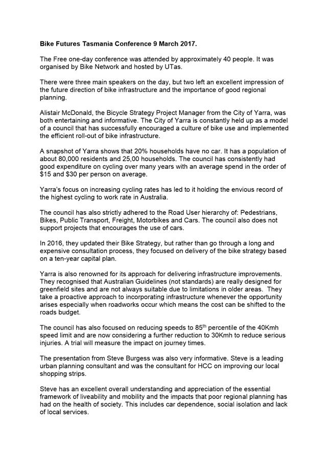
Memorandum: City Infrastructure Committee
Conference Reporting - Bike Futures Conference -
9 March 2017
Alderman Harvey has submitted the attached report in accordance with Clause C(7)(1)(i) of the Council’s policy titled Aldermanic Development and Support.
|
That the information be received and noted.
|
As signatory to this report, I certify that, pursuant to Section 55(1) of the Local Government Act 1993, I hold no interest, as referred to in Section 49 of the Local Government Act 1993, in matters contained in this report.
|
Heather Salisbury Acting General Manager |
|
Date: 13 April 2017
File Reference: F17/38975
Attachment a: Bike
Futures Conference Report ⇩ ![]()
|
Item No. 6.3 |
Agenda (Open Portion) City Infrastructure Committee Meeting - 26/4/2017 |
Page 104 ATTACHMENT a |
|
Agenda (Open Portion) City Infrastructure Committee Meeting |
Page 105 |
|
|
|
26/4/2017 |
|
6.4 South Hobart Pedestrian Improvements
File Ref: F17/39179; RFS16-0080
Report of the Manager Traffic Engineering and the Director Infrastruture Services of 20 April 2017 and attachments.
Delegation: Council
|
Item No. 6.4 |
Agenda (Open Portion) City Infrastructure Committee Meeting |
Page 107 |
|
|
26/4/2017 |
|
REPORT TITLE: South Hobart Pedestrian Improvements
REPORT PROVIDED BY: Manager Traffic Engineering
Director City Infrastructure
1. Report Purpose and Community Benefit
1.1. This report is in response to the Council's 21 December 2015 resolution (point 3) that detailed design work be undertaken for improved pedestrian crossing facilities in South Hobart in line with the concepts described in "A Plan for Hobart's Retail Precincts" with a view to works being undertaken in 2016/2017.
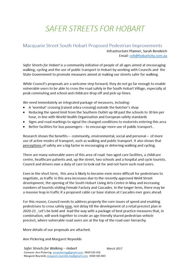
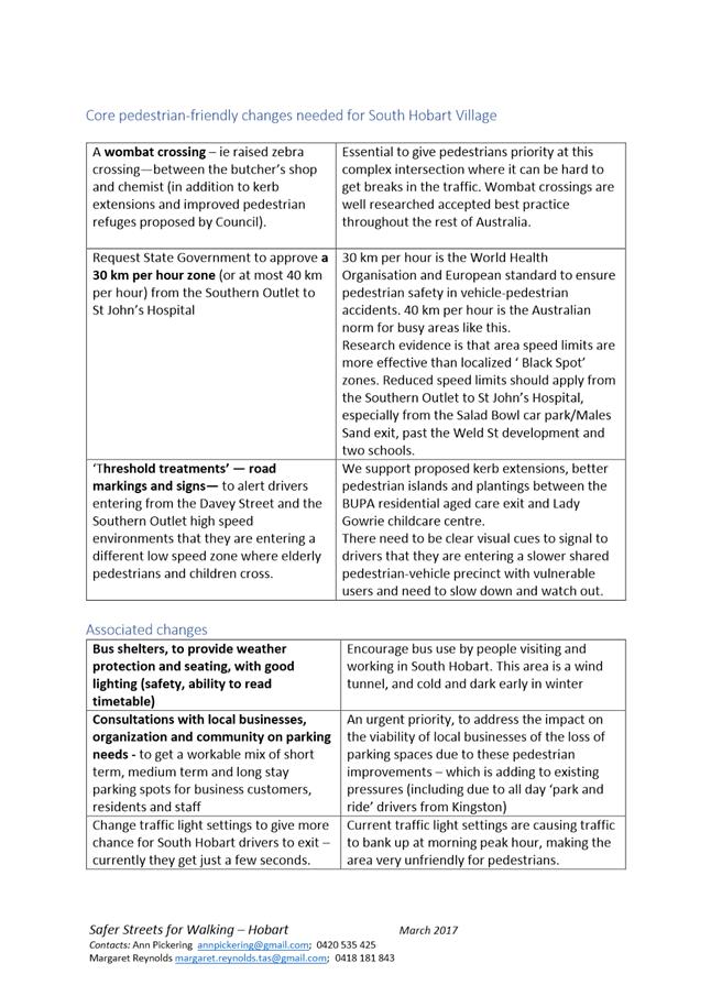
1.2. The purpose of the report is to:
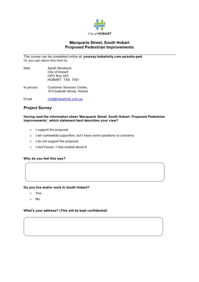
1.2.1. Present a proposal for a suite of pedestrian improvements in Macquarie Street, South Hobart;
1.2.2. Report the outcomes of community engagement which indicates a generally high level of community support, with a small number of representations against the proposal; and
1.2.3. Recommend that the Council apply to the Transport Commissioner for approval to install the five road humps that are required to achieve the proposal.
1.3. The proposed project will provide a range of benefits to the community, including:
1.3.1. Improvements to pedestrian road safety;
1.3.2. Better opportunities for people who experience difficulties with mobility to participate equally, by improving access to services, shops, schools and bus stops, and as a number of road crossings are not currently DDA compliant; and
1.3.3. Support for the South Hobart community to make active transport choices by improving pedestrian and cycling infrastructure.
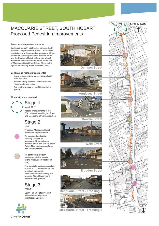
1.4. The pedestrian improvements would provide a positive first step towards a more comprehensive streetscape revitalisation that is planned for the South Hobart Retail Precinct in 2020/2021.
2. Report Summary
2.1. The proposal for pedestrian improvements in South Hobart is outlined in Attachment A to this report. There are two parts to the proposal:
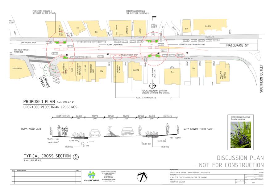
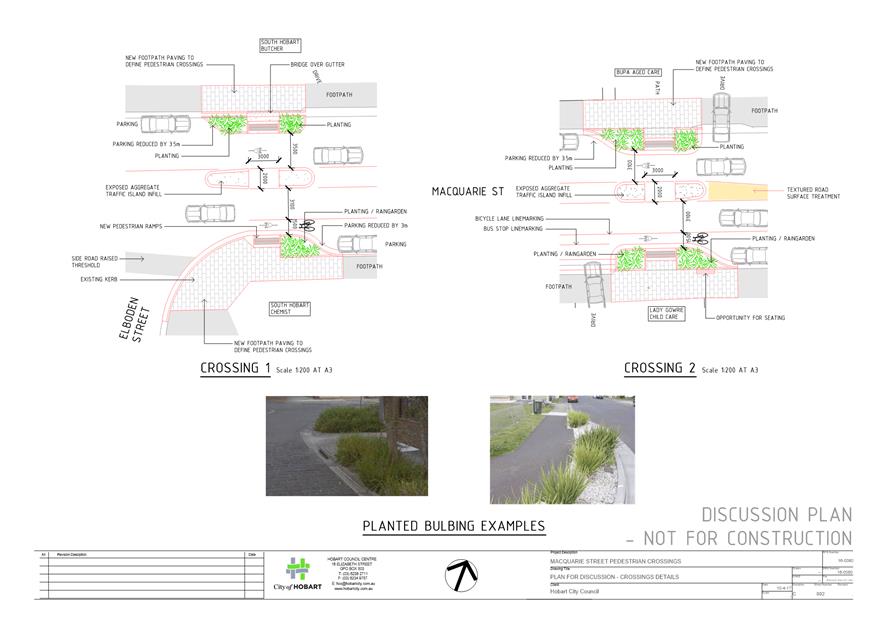
2.1.1. Part one will upgrade the two existing pedestrian crossing facilities in Macquarie Street between Elboden Street and Southern Outlet. Landscaped kerb extensions and larger pedestrian refuges will make it safer and more comfortable for pedestrians to cross Macquarie Street.
The first stage is an approved Black Spot Road Safety project, and has funding from the commonwealth program. It was successfully nominated by members of the South Hobart community. The design for this Black Spot project is included in Attachment B to this report.
2.1.2. Part two would provide a level, step free footpath along the south side of Macquarie Street, from D'Arcy Street to the Southern Outlet. To achieve this, five road humps would be installed and these require State Government approval.
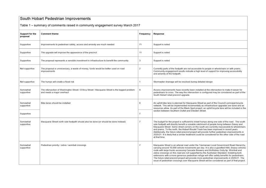
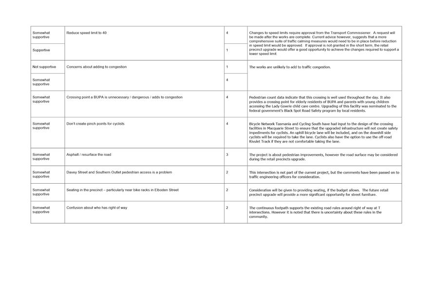
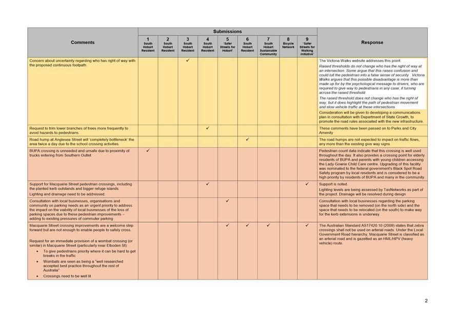
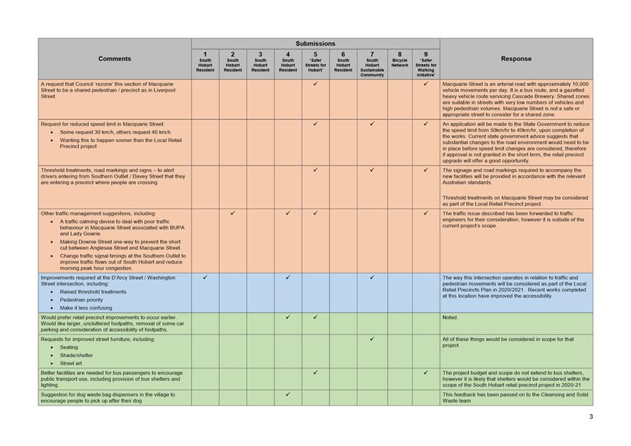
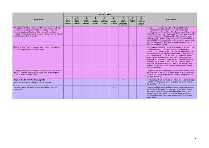
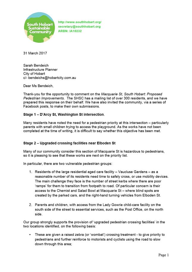
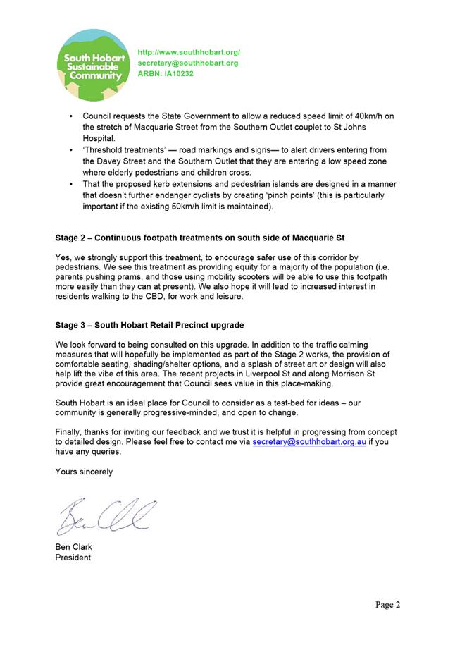
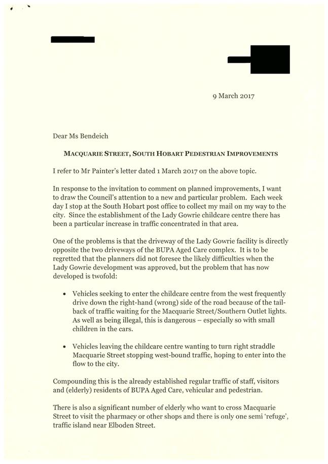
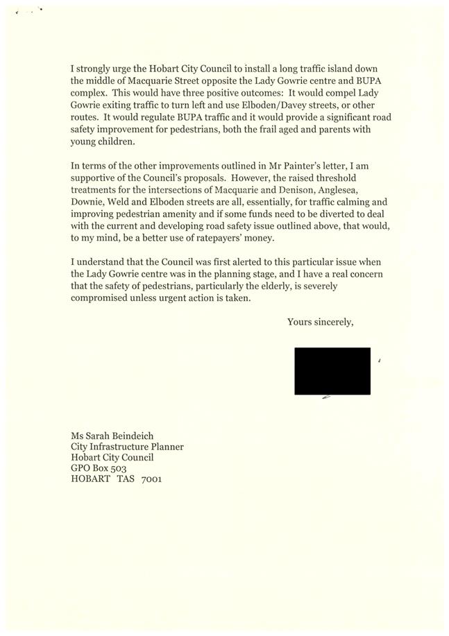
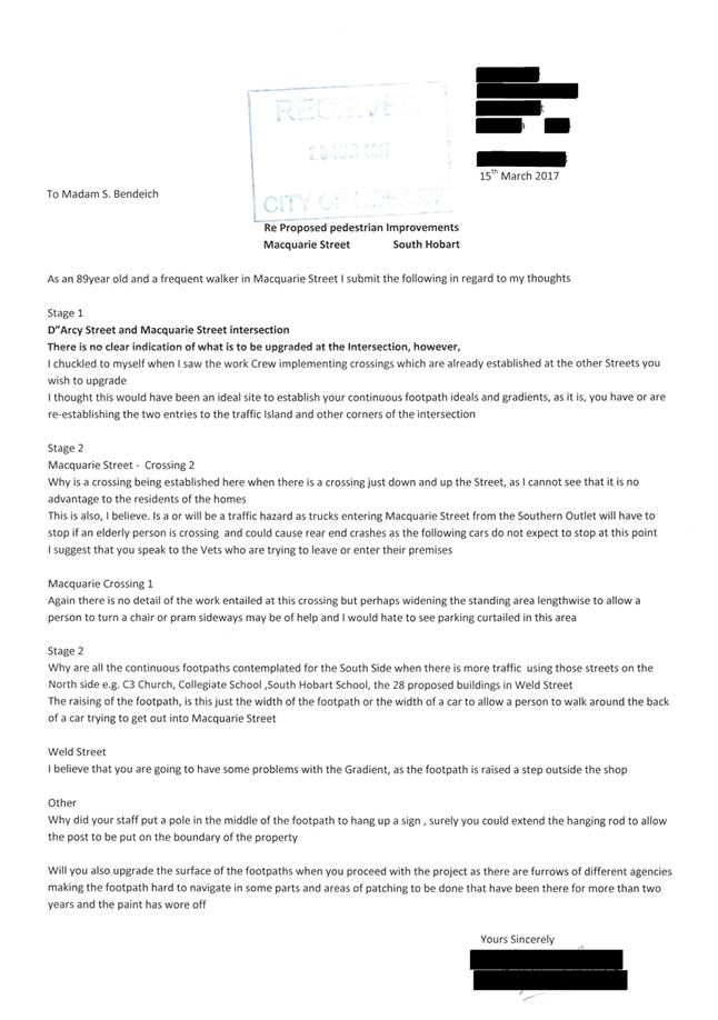
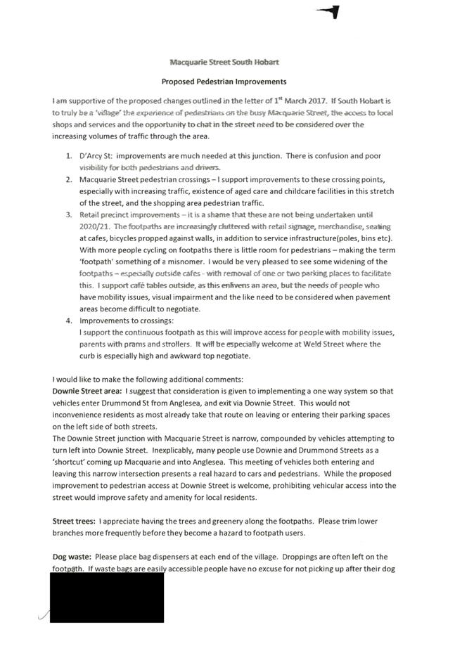
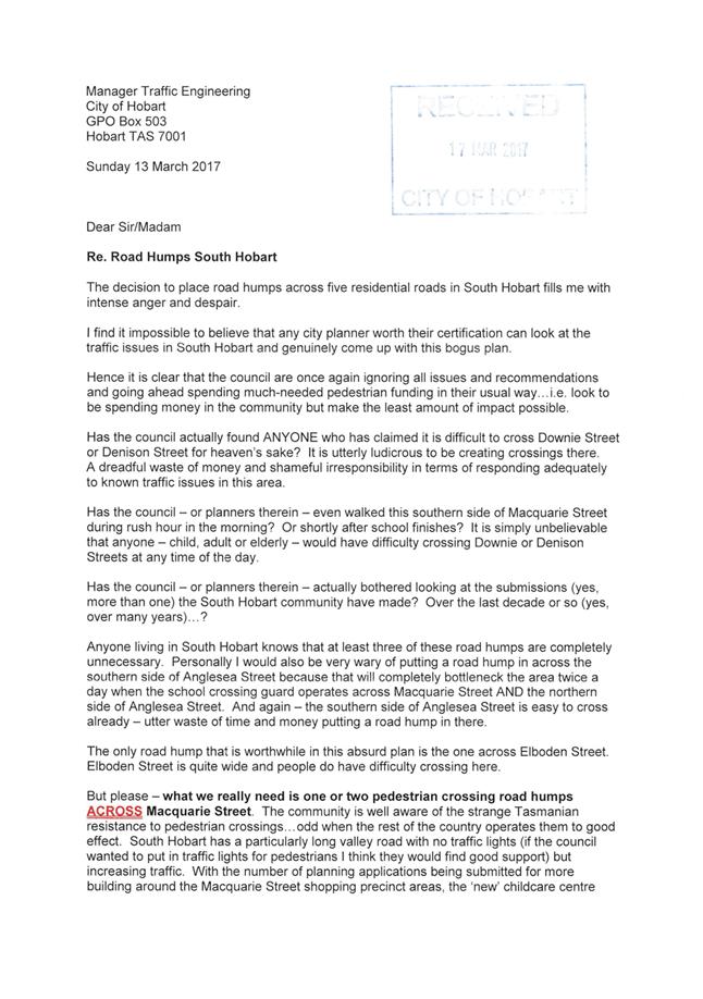
2.2. A program of community engagement was undertaken throughout March 2017. The results of the engagement indicate generally high levels of support for the proposal amongst local stakeholders, with some concerns raised. A summary of the issues raised, and responses to them, are documented in section 12 of this report. The engagement results and the written submissions are included in Attachment C to this report.
2.3. The project is fully funded in the current financial year.
2.4. In order to install the road humps the Council is required to seek permission from the Transport Commissioner, providing any representations and the Council's comments regarding those representations.
|
That: 1. The General Manager write to the Transport Commissioner requesting approval for the installation of the five 'road hump' treatments in Denison Street, Anglesea Street, Downie Street, Weld Street and Elboden Street, where those streets join Macquarie Street on the southern side (as shown in the drawing marked as Attachment A). 2. Subject to approval from the Transport Commissioner, works be undertaken to provide a step free continuous footpath along the southern side of Macquarie Street South Hobart, between D’Arcy Street and the Southern Outlet. 3. Residents who made representations regarding the 'road humps' be notified of the Council's decision.
|
4. Background
4.1. At its meeting held on 21 December 2015 the Council received and noted a report on the Local Retail Precincts Plan. The Council resolved the following:
"That: 1. The Council endorse "A Plan for Hobart's Local Retail Precincts", marked as attachment A to item 10 of the Open City Infrastructure Committee agenda, as the framework basis for developing the City's significant local retail precincts.
2. Detailed design work be undertaken for the Lenah Valley retail precinct based on the concept design provided in "A Plan for Hobart's Local Retail Precincts", and a further report be provided once detailed design and community and trader engagement has been completed in 2016, with a view to the works being completed in 2017/2018.
3. Detail design work be undertaken for improved pedestrian crossing facilities in South Hobart in line with the concepts described in "A Plan for Hobart's Local Retail Precincts" with a view to works being undertaken in 2016/2017.
4. An implementation plan based on "A Plan for Hobart's Local Retail Precincts" and the decisions of the Council in relation to this matter be provided to the traders and other stakeholders who participated in the development of the Plan."
4.2. Clause 3 of the Council's resolution is relevant to this report.
4.3. Improvements to the two crossing points on Macquarie Street between Elboden Street and the Southern Outlet were nominated for funding under the Australian Government's 2016/2017 Black Spot Program.
4.4. Nominations were submitted by members of the local community who were concerned about safety of pedestrians using these crossings, and the nomination was supported by the Council.
4.5. The Department of State Growth's Manager Traffic Safety wrote to the Council's General Manager on 26 July 2016 to advise that the Black Spot program had approved funding to install kerb extensions at the crossing points in Macquarie Street between Elboden Street and the Southern Outlet. The program was to provide $20,000 and the Council was to contribute $20,000.
4.6. The Department of State Growth's safety audit proposal of September 2015 stated:
"Kerb extensions at the existing pedestrian refuges would improve sight distance between pedestrians waiting to cross the road and approaching traffic. The kerb extensions will also reduce the distance which the pedestrians have to cross".
4.7. Additional funding was included in the Ten Year Capital Works Program.
4.8. The project "South Hobart Pedestrian Crossing" is included in the Council's endorsed ten year capital works program, under the Local Retail Precincts Program, with a budget of $350,000 in 2016/2017. This was to provide 'more generous' pedestrian crossings as highlighted in the Local Retail Precincts Plan.
4.9. However, in designing the Macquarie Street pedestrian crossings it was clear that the $350,000 budget was more than required to implement this project.
4.10. Other pedestrian improvement projects for South Hobart were explored and the option to improve the pedestrian path between the Southern Outlet and D'Arcy Street was developed.
5. Proposal and Implementation
Part one
5.1. Part one of the project will involve the pedestrian crossing upgrades in Macquarie Street. This is the approved Black Spot portion of the project. The design is included as Attachment B, however it is presented in this report for context and information only. The works are approved and funded, detail design is nearing completion and construction is expected to commence in June 2017.
5.2. These pedestrian crossing upgrades will include:
(i) Wider, more generous pedestrian refuge islands.
(ii) Landscaped kerb extensions with kerb ramps, tactile indicators and low level, grassy plantings.
(iii) Renewed footpath surfaces behind the kerb extensions.
(iv) Changes to storm water drainage including rain gardens incorporated with the landscaped areas, where this can be achieved.
Part two
5.3. Part two of the proposal is for the construction of a continuous, level, step free footpath along the south side of Macquarie Street, between D’Arcy Street and Elboden Street.
5.4. It is proposed that the works required to install this would commence immediately after Part One is complete. This would likely be in or around July 2017.
5.5. The continuous footpath would be achieved by installing five road humps at the side streets of Denison Street, Anglesea Street, Downie Street, Weld Street and Elboden Street, where they intersect with Macquarie Street.
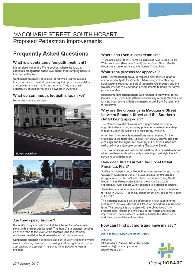
5.6. The road humps are a gradual ramping up of the road surface to meet the height of the footpath.
5.7. Pedestrians are able to continue across the road at a continuous level rather than stepping down to the road level and stepping back up again.
5.8. This provides benefits for all pedestrians, but is particularly beneficial for elderly, mobility-impaired people, people in wheelchairs, people with prams and young children.
5.9. Macquarie Street, in the South Hobart retail precinct, has been identified by the City of Hobart’s Access Advisory Committee (AAC) as an ‘access priority route’. This means that improved pedestrian accessibility is a high priority for that committee. Several streets are not DDA compliant, for example Weld Street and Downie Street do not have kerb ramps on the southern side of Macquarie Street.
5.10. Continuous footpaths are increasingly used interstate to improve pedestrian amenity, particularly in retail precincts and local areas where there are high pedestrian volumes.
5.11. They are well-suited to retrofitting into older streetscapes and are recommended by Victoria Walks at all side-street locations when infrastructure is being upgraded. Some interstate examples are shown below.
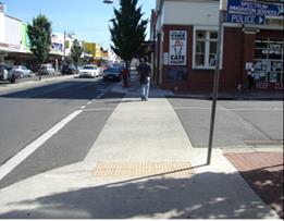
Figure 1: City of Darebin (image courtesy Victoria Walks)
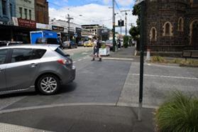
Figure 2: Glenferrie Road, Hawthorn, Victoria
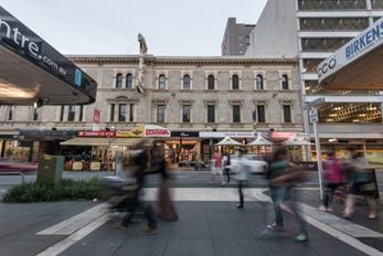
Figure 3: City of Adelaide (image courtesy Adelaide Design Manual)
5.12. Similar road humps have been installed recently by City of Hobart, as part of pedestrian infrastructure improvements in Morrison Street, and also in Gore Street, South Hobart near the entrance to the Hobart Rivulet Park (shown below).
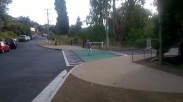
Figure 4 Road hump at Gore Street and McKellar Street, South Hobart
5.13. Observations are that these examples appear to be operating well, supporting pedestrian amenity and calming traffic at the intersections.
5.14. The road humps do not create significant inconvenience for motorists. This is because they are located at T-intersections, where the motorist is already required to slow down to give way. It is also due to their gently inclining ramp – they are not designed to be a ‘speed bump’.
5.15. Approval by the State Government’s Transport Commissioner is required for installation of road humps. Advertising appeared in the Saturday Mercury newspaper twice during March 2017, in accordance with Section 31 of the Local Government (Highways) Act 1982 (The Act).
5.16. In addition to the statutory requirement for advertising, community engagement was undertaken to gauge community support for the proposal.
5.17. Most surveys and submissions received were supportive of the five raised humps, however one formal representation, a small number of unsupportive survey responses and a number of submissions which requested different treatments, were received.
5.18. Under the Act, the Council is required to submit copies of any representations together with the Council’s comments to the Transport Commissioner, in order to seek approval for the road humps.
5.19. A summary of the points raised, and officer comments, are detailed in Section 12.
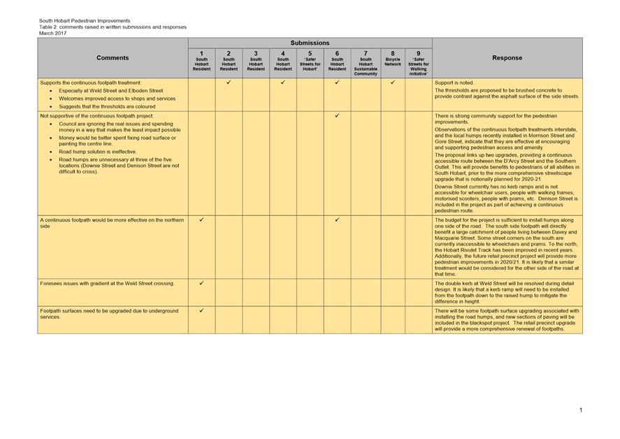
5.20. The written submissions received, are included in Attachment C to this report.
6. Strategic Planning and Policy Considerations
6.1. The proposal furthers the following strategic objectives from the Capital City Strategic Plan 2015-2025, namely:
“2.1 A fully connected and accessible city environment; and
2.2 A people-focused city with well-designed and well managed urban spaces.”
6.2. The proposal furthers the intents of the Council’s Equal Access Strategy.
7. Financial Implications
7.1. Funding Source and Impact on Current Year Operating Result
7.1.1 The project is fully funded in the current year capital works program.
7.2. Impact on Future Years' Financial Result
7.2.1 The ten year capital works program includes additional streetscape improvements in South Hobart as part of the implementation of the Local Retail Precincts Plan. This is programmed for 2020/2021.
7.3. Asset Related Implications
7.3.1 Depreciation will increase by about $5,000 per annum.
7.3.2 Some write-off costs associated with replacing existing kerb and channel are likely, however these will be minor.
7.3.3 There will be some additional operational and maintenance costs associated with the new infrastructure, however these will be minor.
8. Legal, Risk and Legislative Considerations
8.1. The Local Government (Highways) Act 1982, Section 31 requires the Council to apply to the Transport Commissioner for permission to install road humps such as those proposed in Denison Street, Anglesea Street, Downie Street, Weld Street and Elboden Street.
8.2. Safety in design reporting and the appropriate risk management practices will be undertaken as part of the delivery of the project.
9. Environmental Considerations
9.1. The project supports sustainable transport choices by improving pedestrian infrastructure.
10. Social and Customer Considerations
10.1. The proposal will increase the opportunity for people who experience difficulties with mobility to participate equally by improving access to services, shops, schools and bus stops.
11. Marketing and Media
11.1. Hobart's Your Say site has been used to communicate the proposal with the community and collect on-line survey responses. The engagement was promoted on the City of Hobart's Facebook page.
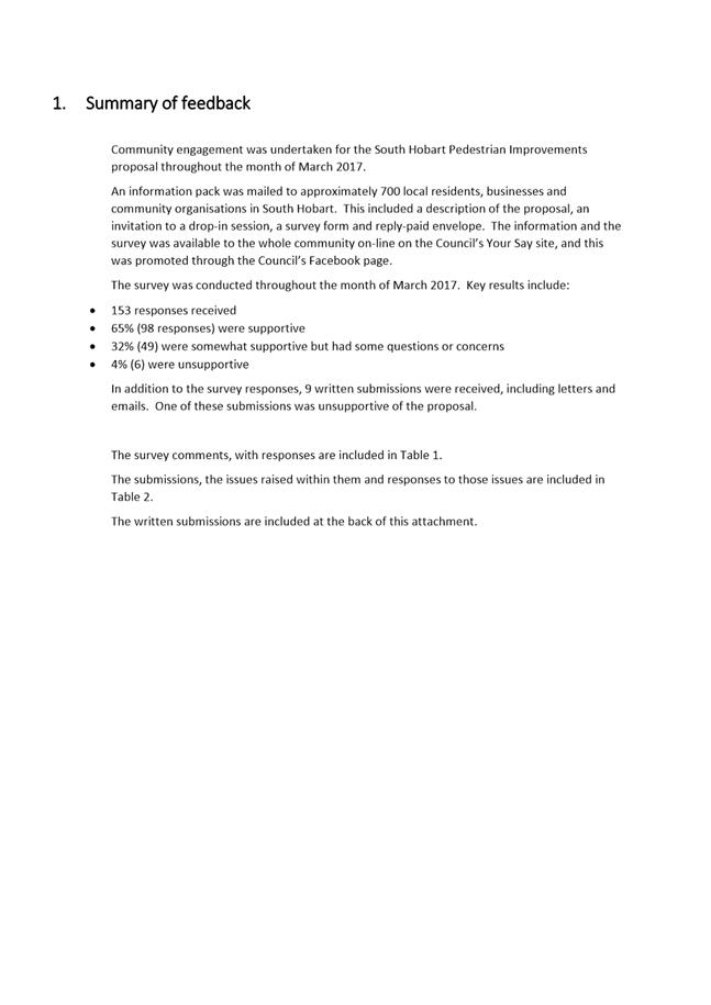
12. Community and Stakeholder Engagement
Engagement undertaken
12.1. The local community and other stakeholders have been consulted about the proposal. Key methods included:
12.1.1. An information sheet describing the proposal, a covering letter, feedback survey and reply paid envelope sent to:
(i) Approximately 700 local owners, residents and businesses in the area
(ii) South Hobart Resident Traffic Committee
(iii) South Hobart Progress Association
(iv) South Hobart Sustainable Community
12.1.2. A Your Say page was launched at the beginning of March 2017 with information about the proposal and an electronic survey. This was promoted with a post on the City of Hobart's Facebook page.
(i) Two advertisements have been placed in the Saturday Mercury newspaper during March to advise the community of the Council's intention to apply to the State Government for permission to install road humps.
(ii) A community information session was held in the South Hobart Community Hall on the evening of Monday 20 March 2017.
Feedback received
12.2. Some 153 survey responses and nine written or emailed submissions have been received regarding the proposal.
12.3. In summary, the survey found that:
(i) 64% (98) supported the proposal
(ii) 32% (49) were somewhat supportive, but with some questions or concerns
(iii) 4% (6) were unsupportive
(a) Among those who were supportive, their comments indicate that improvements to pedestrian access are welcome. A number of respondents indicated that they, or someone they knew, would directly benefit from the improved access to shops and services that the continuous level footpath would provide. Elboden Street and Weld Street were specifically mentioned as needing improved access.
(b) Among those who were ‘somewhat supportive, but with some questions or concerns’, the main themes of their comments were:
12.3.1 The improvements are welcome, but they are not enough.
Response: The proposal is a positive step towards a more comprehensive streetscape upgrade that is planned for the South Hobart retail precinct in 2020-21. The continuous footpath would link up two upgrades, providing an improved pedestrian route from D’Arcy Street, where maintenance works have recently improved access at this intersection, with the Southern Outlet.
12.3.2 The continuous footpath would be preferred by some on the northern side of Macquarie Street.
Response: The budget for the project is sufficient to install humps along one side of the road. The south side footpath will benefit a large catchment of people living between Davey Street and Macquarie Street. Some street corners on the south side are currently lacking ramps and are inaccessible to wheelchairs and prams. To the north, the Hobart Rivulet shared path has been recently improved. Additionally, the retail precinct upgrade will deliver more extensive pedestrian improvements in 2020-21. It is likely that a similar treatment could be considered for the other side of the road at that time.
12.3.3 Some technical issues were raised – drainage, gradients, surfaces, colour, traffic impacts.
Response: Gradients, levels, drainage and surfaces will be resolved during detailed design. The road humps are unlikely to impact traffic volumes or traffic flow.
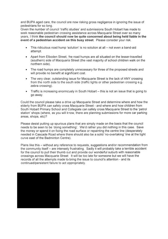
12.4. There was a small number (4%) of survey respondents who were unsupportive, and a single written representation that was unsupportive. The reasons given are summarised below:
12.4.1 Reason: This is not the right solution to the problem. Council is ignoring the real problem which is the difficulty that pedestrians have crossing Macquarie Street.
Response: The community-nominated black spot project is planned for implementation in June and this will provide safer pedestrian crossing facilities in Macquarie Street. The continuous footpath proposal offers clear benefits for pedestrian accessibility within the precinct, and there will be opportunities for further improvements as part of the retail precinct upgrade planned for 2020-21. Further engagement with the community will be undertaken as part of that project.
12.4.2 Reason: There may be uncertainty about who has right of way with the proposed continuous footpath.
Response: The continuous footpath treatment does not change who has right of way, but it does highlight the path of pedestrian movement and slow vehicle traffic at these intersections.
12.4.3 Reason: The road humps will be ineffective.
Response: Observations of the continuous footpath treatments interstate and the two road humps recently installed in Morrison Street and Gore Street indicate that they are effective at providing improved pedestrian access and amenity.
12.4.4 Reason: The continuous footpath is a waste of money or could be spent in better ways.
Response: The road humps are a relatively cost effective way to achieve real benefits for pedestrian access along the length of the South Hobart retail precinct from D’Arcy Street to the Southern Outlet. The continuous footpath will also link together two other upgrades, adding value to these projects.
12.4.5 Reason: The continuous footpath will worsen congestion.
Response: The road humps will provide better pedestrian access at the side street intersections with Macquarie Street. However they are not a ‘speed hump’ and it is unlikely that they would have any effect on traffic flows or volumes.
Additional engagement to be undertaken
12.5. Continuing engagement tasks include:
12.5.1. Replies will be made to people and organisations who have written submissions, advising them of the Council’s resolution.
12.5.2. Should the proposal be approved, there will be continued consultation with stakeholders who will be directly affected by construction activities.
12.5.3. An update will be posted to the Your Say page and an e-newsletter will be distributed to provide information to people who have indicated that they would like to be kept informed.
12.5.4. Further engagement with the South Hobart community will be undertaken as part of the retail precinct streetscape upgrade in 2020/21.
13. Delegation
13.1. This is a matter for the Council to determine.
As signatory to this report, I certify that, pursuant to Section 55(1) of the Local Government Act 1993, I hold no interest, as referred to in Section 49 of the Local Government Act 1993, in matters contained in this report.
|
Angela Moore Manager Traffic Engineering |
Mark Painter Director City Infrastructure |
Date: 20 April 2017
File Reference: F17/39179; RFS16-0080
Attachment a: Concept
proposal ⇩ ![]()
Attachment
b: Black
Spot concept ⇩ ![]()
Attachment
c: Community
engagement results ⇩ ![]()
|
Item No. 6.4 |
Agenda (Open Portion) City Infrastructure Committee Meeting - 26/4/2017 |
Page 117 ATTACHMENT a |
|
Item No. 6.4 |
Agenda (Open Portion) City Infrastructure Committee Meeting - 26/4/2017 |
Page 118 ATTACHMENT a |
|
Item No. 6.4 |
Agenda (Open Portion) City Infrastructure Committee Meeting - 26/4/2017 |
Page 119 ATTACHMENT b |
|
Item No. 6.4 |
Agenda (Open Portion) City Infrastructure Committee Meeting - 26/4/2017 |
Page 120 ATTACHMENT b |
|
Item No. 6.4 |
Agenda (Open Portion) City Infrastructure Committee Meeting - 26/4/2017 |
Page 122 ATTACHMENT c |
|
Item No. 6.4 |
Agenda (Open Portion) City Infrastructure Committee Meeting - 26/4/2017 |
Page 125 ATTACHMENT c |
|
Item No. 6.4 |
Agenda (Open Portion) City Infrastructure Committee Meeting - 26/4/2017 |
Page 126 ATTACHMENT c |
|
Item No. 6.4 |
Agenda (Open Portion) City Infrastructure Committee Meeting - 26/4/2017 |
Page 127 ATTACHMENT c |
|
Item No. 6.4 |
Agenda (Open Portion) City Infrastructure Committee Meeting - 26/4/2017 |
Page 128 ATTACHMENT c |
|
Item No. 6.4 |
Agenda (Open Portion) City Infrastructure Committee Meeting - 26/4/2017 |
Page 129 ATTACHMENT c |
|
Item No. 6.4 |
Agenda (Open Portion) City Infrastructure Committee Meeting - 26/4/2017 |
Page 130 ATTACHMENT c |
|
Item No. 6.4 |
Agenda (Open Portion) City Infrastructure Committee Meeting - 26/4/2017 |
Page 132 ATTACHMENT c |
|
Agenda (Open Portion) City Infrastructure Committee Meeting |
Page 146 |
|
|
|
26/4/2017 |
|
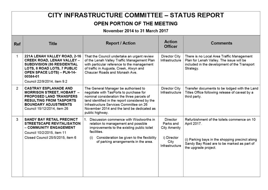
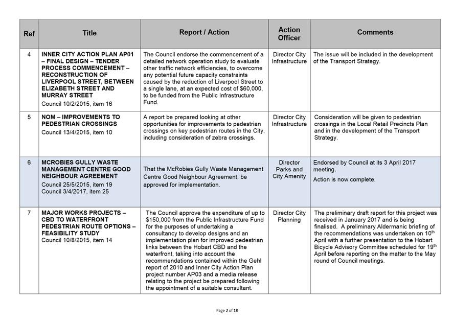
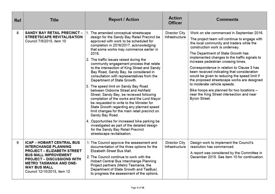
A report indicating the status of current decisions is attached for the information of Aldermen.
REcommendation
That the information be received and noted.
Delegation: Committee
|
Item No. 7.1 |
Agenda (Open Portion) City Infrastructure Committee Meeting - 26/4/2017 |
Page 148 ATTACHMENT a |
|
Agenda (Open Portion) City Infrastructure Committee Meeting |
Page 166 |
|
|
|
26/4/2017 |
|
Regulation 29(3) Local Government
(Meeting Procedures) Regulations 2015.
File Ref: 13-1-10
The General Manager reports:-
“In accordance with the procedures approved in respect to Questions Without Notice, the following responses to questions taken on notice are provided to the Committee for information.
The Committee is reminded that in accordance with Regulation 29(3) of the Local Government (Meeting Procedures) Regulations 2015, the Chairman is not to allow discussion or debate on either the question or the response.”
8.1 Drainage in Marieville Esplanade Car Park
File Ref: F17/33625; 13-1-10
Report of the Director City Infrastructure of 26 April 2017.
Delegation: Committee
|
That the information be received and noted.
|
|
Item No. 8.1 |
Agenda (Open Portion) City Infrastructure Committee Meeting |
Page 168 |
|
|
26/4/2017 |
|
Memorandum: Lord Mayor
Deputy Lord Mayor
Aldermen
Response to Question Without Notice
Drainage in Marieville Esplanade Car Park
|
Meeting: City Infrastructure Committee
|
Meeting date: 29 March 2017
|
|
Raised by: Alderman Ruzicka |
|
Question:
1. What works are planned to prevent pooling of water during rain inundation events in the car park area at the Queen Street end of Marieville Esplanade?
2. If drainage works are planned, what is the timetable for works?
3. If no works are planned, what measures can be taken to alleviate the pooling of water during rain inundation events?
Response:
1. A significant asset renewal project is planned for the northern end of Marieville Esplanade and this work will include drainage improvements in the carpark area in question. This project will also investigate and address (where possible), other issues such as: construction of a formalised footpath along the frontages of 2-10 Marieville Esplanade, provision of cycle friendly access along Marieville Esplanade, beach protection measures where appropriate, and accessibility for service vehicles etc.
2. The abovementioned project is scheduled for construction in the 2018/2019 capital works program.
3. Once design work has been substantially completed, it may be expedient and practicable to install some early drainage works e.g. pit(s), that will not compromise the final design but will provide some relief to ponding in this area. Obviously the design priority for this project is balanced against other competing design demands, and in particular projects that are scheduled for construction at an earlier time.
As signatory to this report, I certify that, pursuant to Section 55(1) of the Local Government Act 1993, I hold no interest, as referred to in Section 49 of the Local Government Act 1993, in matters contained in this report.
|
Mark Painter Director City Infrastructure |
|
Date: 20 April 2017
File Reference: F17/33625; 13-1-10
|
|
Agenda (Open Portion) City Infrastructure Committee Meeting |
Page 169 |
|
|
26/4/2017 |
|
Section 29 of the Local Government (Meeting Procedures) Regulations 2015.
File Ref: 13-1-10
An Alderman may ask a question without notice of the Chairman, another Alderman, the General Manager or the General Manager’s representative, in line with the following procedures:
1. The Chairman will refuse to accept a question without notice if it does not relate to the Terms of Reference of the Council committee at which it is asked.
2. In putting a question without notice, an Alderman must not:
(i) offer an argument or opinion; or
(ii) draw any inferences or make any imputations – except so far as may be necessary to explain the question.
3. The Chairman must not permit any debate of a question without notice or its answer.
4. The Chairman, Aldermen, General Manager or General Manager’s representative who is asked a question may decline to answer the question, if in the opinion of the respondent it is considered inappropriate due to its being unclear, insulting or improper.
5. The Chairman may require a question to be put in writing.
6. Where a question without notice is asked and answered at a meeting, both the question and the response will be recorded in the minutes of that meeting.
7. Where a response is not able to be provided at the meeting, the question will be taken on notice and
(i) the minutes of the meeting at which the question is asked will record the question and the fact that it has been taken on notice.
(ii) a written response will be provided to all Aldermen, at the appropriate time.
(iii) upon the answer to the question being circulated to Aldermen, both the question and the answer will be listed on the agenda for the next available ordinary meeting of the committee at which it was asked, where it will be listed for noting purposes only.
|
|
Agenda (Open Portion) City Infrastructure Committee Meeting |
Page 170 |
|
|
26/4/2017 |
|