City
of hobart
AGENDA
City Planning Committee Meeting
Open Portion
Monday, 27 February 2017
at 5.00 pm
Lady Osborne Room, Town Hall
City
of hobart
AGENDA
City Planning Committee Meeting
Open Portion
Monday, 27 February 2017
at 5.00 pm
Lady Osborne Room, Town Hall
THE MISSION
Our mission is to ensure good governance of our capital City.
THE VALUES
The Council is:
|
about people |
We value people – our community, our customers and colleagues. |
|
professional |
We take pride in our work. |
|
enterprising |
We look for ways to create value. |
|
responsive |
We’re accessible and focused on service. |
|
inclusive |
We respect diversity in people and ideas. |
|
making a difference |
We recognise that everything we do shapes Hobart’s future. |
|
|
Agenda (Open Portion) City Planning Committee Meeting |
Page 4 |
|
|
27/2/2017 |
|
Business listed on the agenda is to be conducted in the order in which it is set out, unless the committee by simple majority determines otherwise.
APOLOGIES AND LEAVE OF ABSENCE
1. Co-Option of a Committee Member in the event of a vacancy
3. Consideration of Supplementary Items
4. Indications of Pecuniary and Conflicts of Interest
6. Planning Authority Items - Consideration of Items With Deputations
7. Committee Acting as Planning Authority
7.1 Applications under the Hobart Interim Planning Scheme 2015
8.2 Delegated Decisions Report (Planning)
8.3 City Planning - Advertising List
9. Responses To Questions Without Notice
9.1 Matters to be considered regarding subdivision applications
9.2 Impact of new Building Act and Regulations
11. Closed Portion Of The Meeting
|
|
Agenda (Open Portion) City Planning Committee Meeting |
Page 6 |
|
|
27/2/2017 |
|
City Planning Committee Meeting (Open Portion) held Monday, 27 February 2017 at 5.00 pm in the Lady Osborne Room, Town Hall.
|
COMMITTEE MEMBERS Briscoe (Chairman) Ruzicka Burnet Denison
ALDERMEN Lord Mayor Hickey Deputy Lord Mayor Christie Zucco Sexton Cocker Thomas Reynolds Harvey |
Apologies:
Leave of Absence:
|
|
The minutes of the Open Portion of the City Planning Committee meeting held on Tuesday, 14 February 2017 and the Special City Planning Committee meeting held on Monday, 20 February 2017, are submitted for confirming as an accurate record.
|
Ref: Part 2, Regulation 8(6) of the Local Government (Meeting Procedures) Regulations 2015.
|
That the Committee resolve to deal with any supplementary items not appearing on the agenda, as reported by the General Manager.
|
Ref: Part 2, Regulation 8(7) of the Local Government (Meeting Procedures) Regulations 2015.
Aldermen are requested to indicate where they may have any pecuniary or conflict of interest in respect to any matter appearing on the agenda, or any supplementary item to the agenda, which the committee has resolved to deal with.
Regulation 15 of the Local Government (Meeting Procedures) Regulations 2015.
A committee may close a part of a meeting to the public where a matter to be discussed falls within 15(2) of the above regulations.
In the event that the committee transfer an item to the closed portion, the reasons for doing so should be stated.
Are there any items which should be transferred from this agenda to the closed portion of the agenda, or from the closed to the open portion of the agenda?
In accordance with the requirements of Part 2 Regulation 8(3) of the Local Government (Meeting Procedures) Regulations 2015, the General Manager is to arrange the agenda so that the planning authority items are sequential.
In accordance with Part 2 Regulation 8(4) of the Local Government (Meeting Procedures) Regulations 2015, the Committee by simple majority may change the order of any of the items listed on the agenda, but in the case of planning items they must still be considered sequentially – in other words they still have to be dealt with as a single group on the agenda.
Where deputations are to be received in respect to planning items, past practice has been to move consideration of these items to the beginning of the meeting.
RECOMMENDATION
That in accordance with Regulation 8(4) of the Local Government (Meeting Procedures) Regulations 2015, the Committee resolve to deal with any items which have deputations by members of the public regarding any planning matter listed on the agenda, to be taken out of sequence in order to deal with deputations at the beginning of the meeting.
|
|
Agenda (Open Portion) City Planning Committee Meeting |
Page 7 |
|
|
27/2/2017 |
|
In accordance with the provisions of Part 2 Regulation 25 of the Local Government (Meeting Procedures) Regulations 2015, the intention of the Committee to act as a planning authority pursuant to the Land Use Planning and Approvals Act 1993 is to be noted.
In accordance with Regulation 25, the Committee will act as a planning authority in respect to those matters appearing under this heading on the agenda, inclusive of any supplementary items.
The Committee is reminded that in order to comply with Regulation 25(2), the General Manager is to ensure that the reasons for a decision by a Council or Council Committee acting as a planning authority are recorded in the minutes.
|
Agenda (Open Portion) City Planning Committee Meeting |
Page 9 |
|
|
|
27/2/2017 |
|
7.1 Applications under the Hobart Interim Planning Scheme 2015
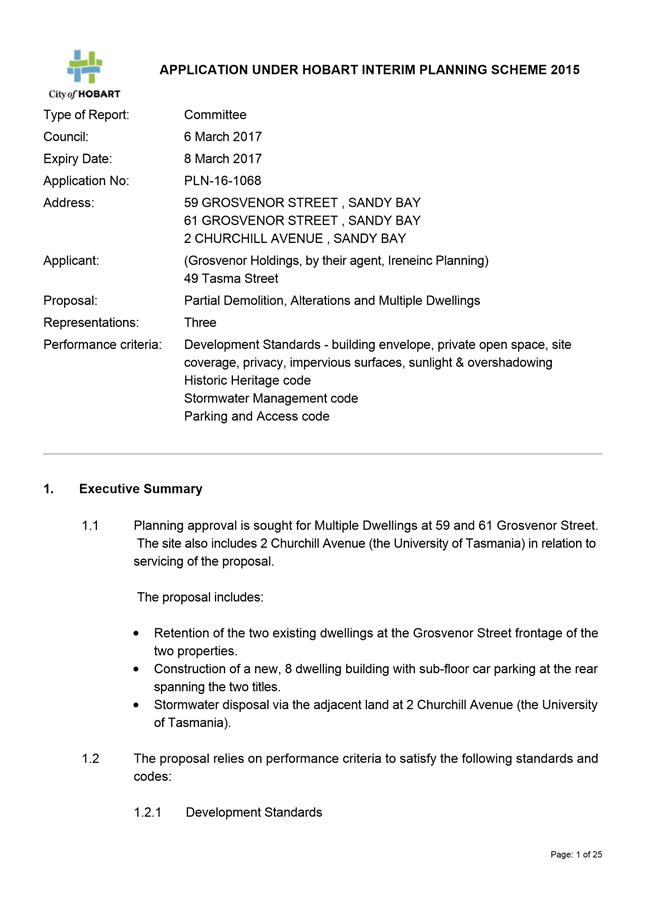
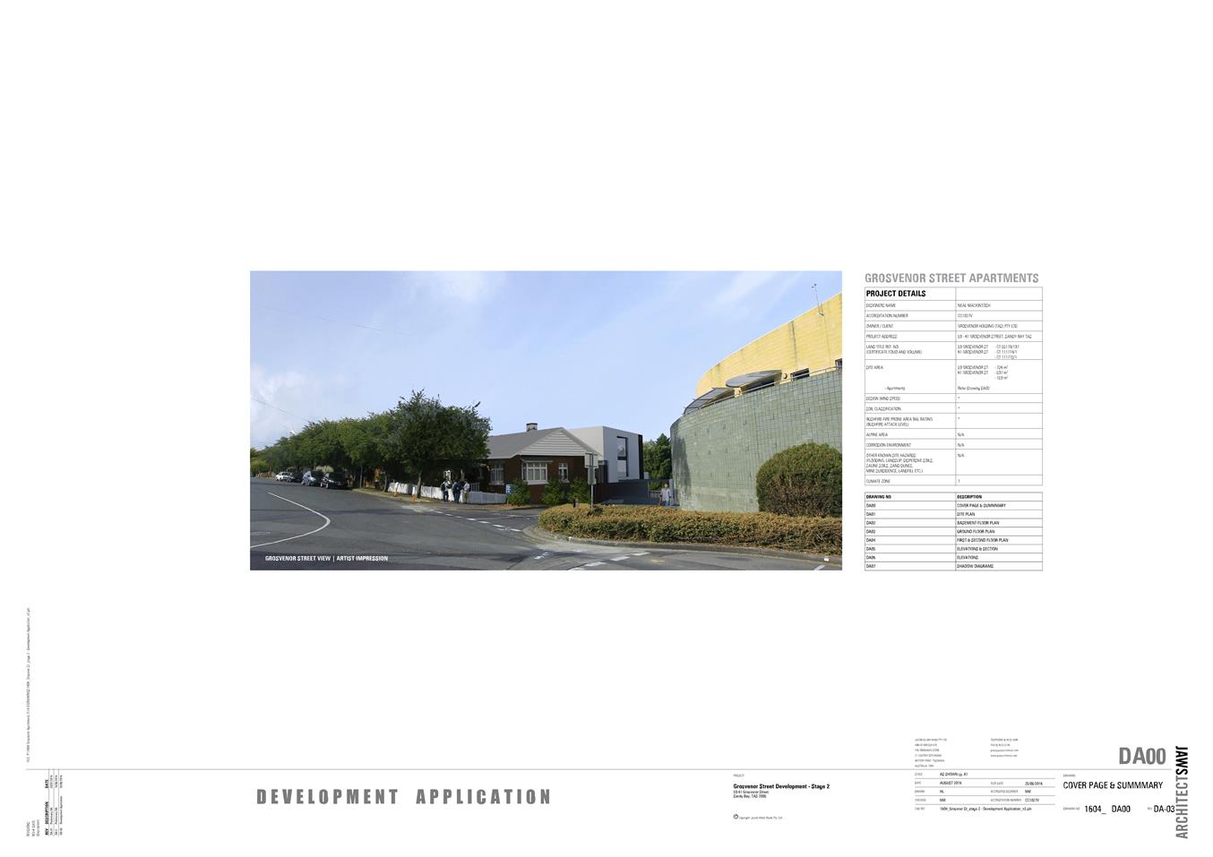
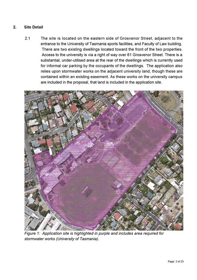
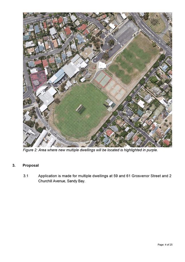
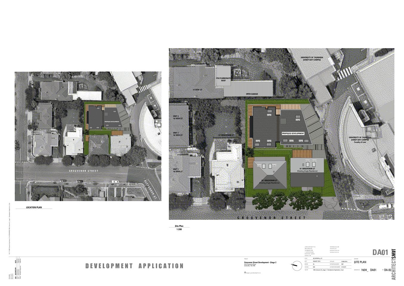
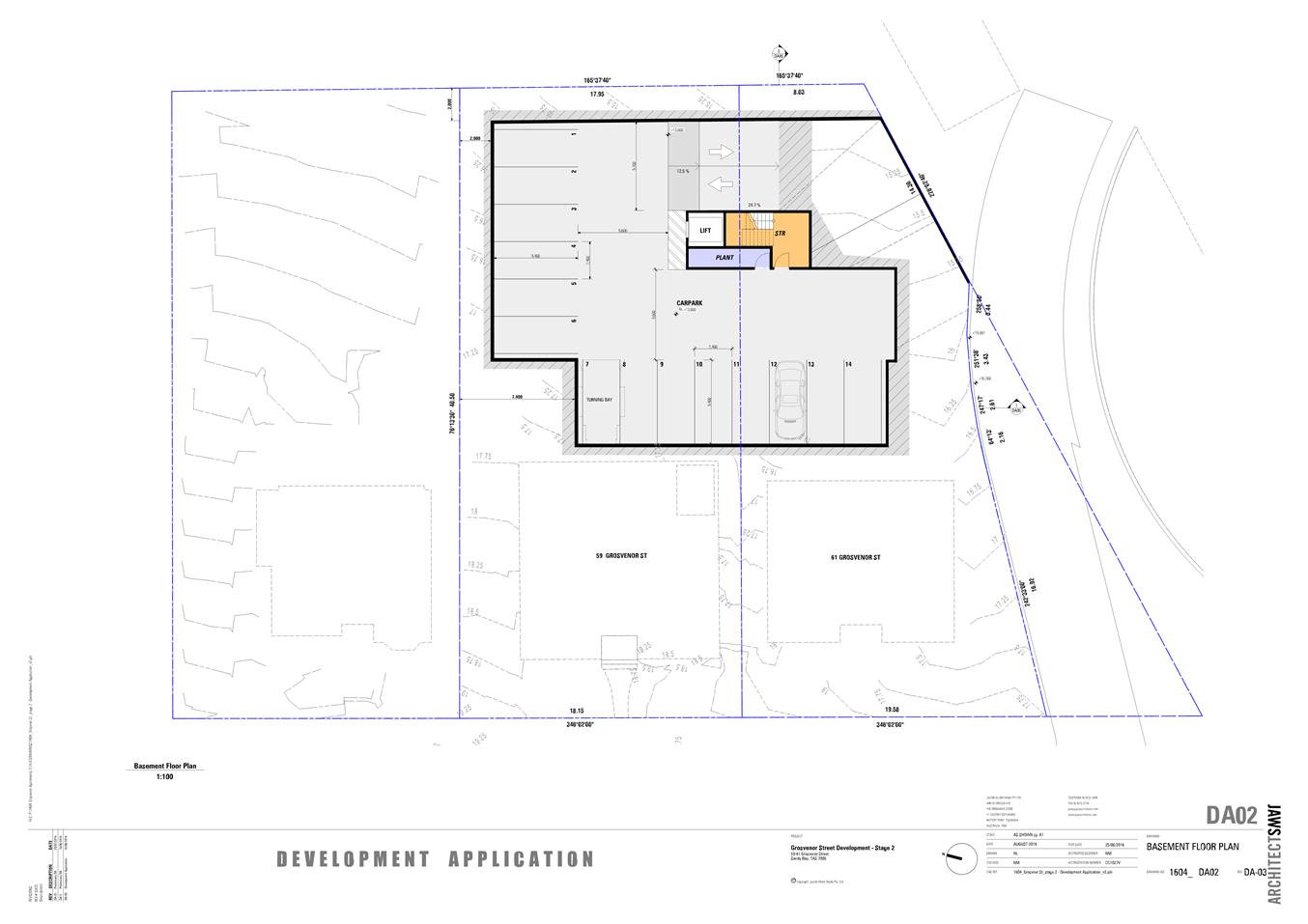
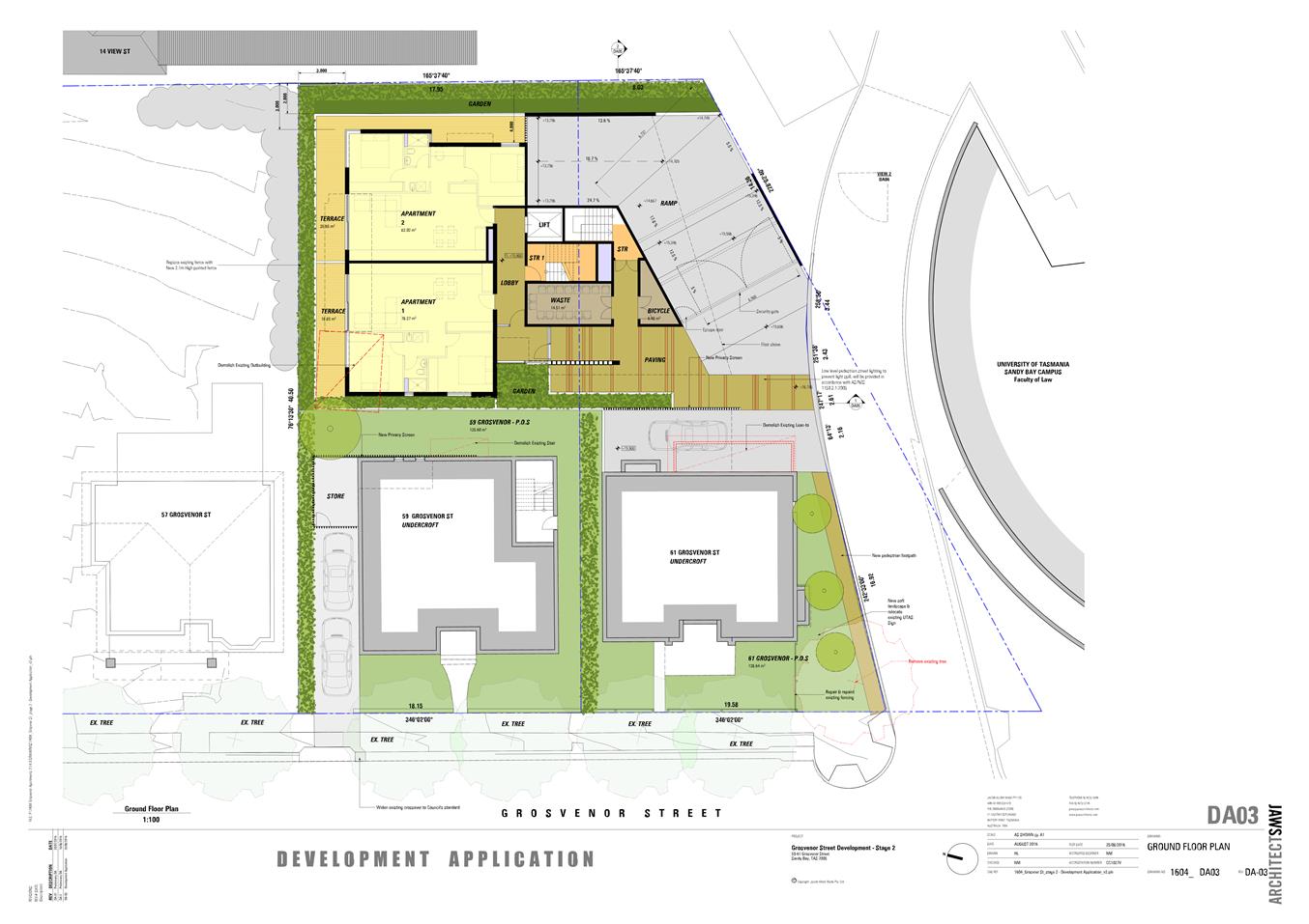
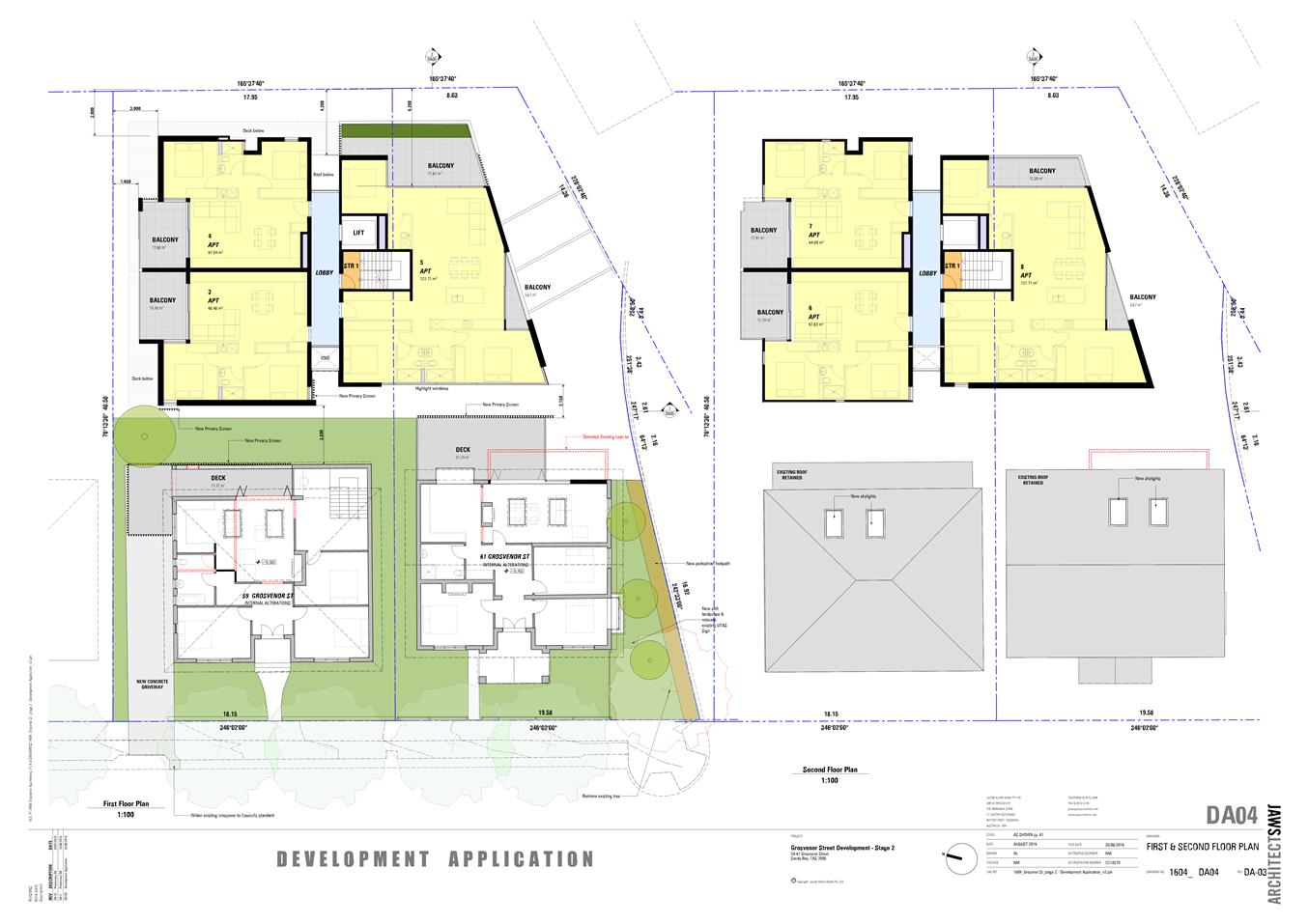
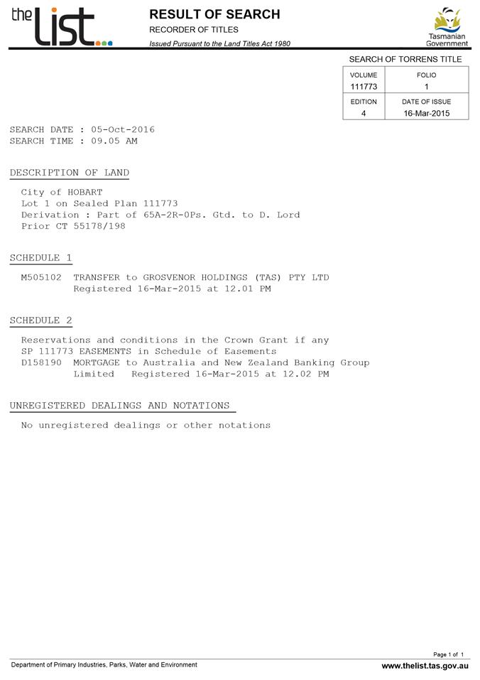
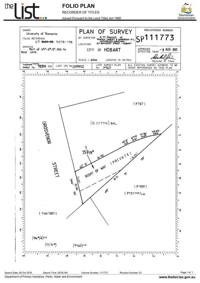
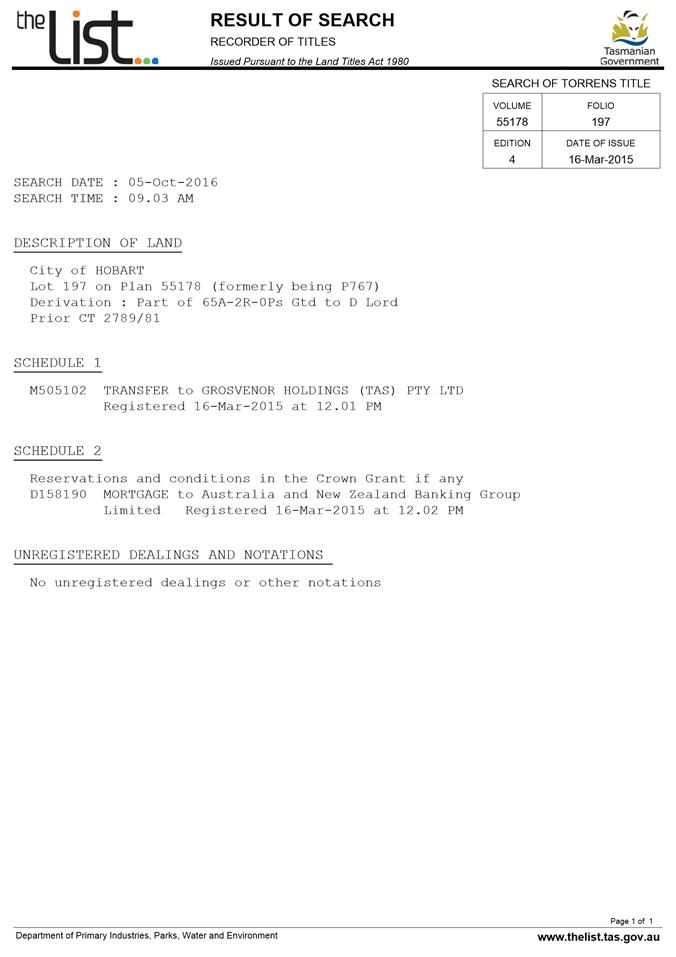
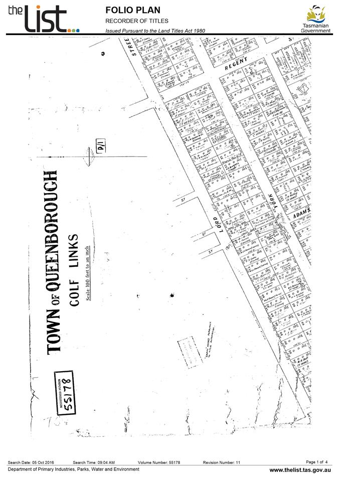
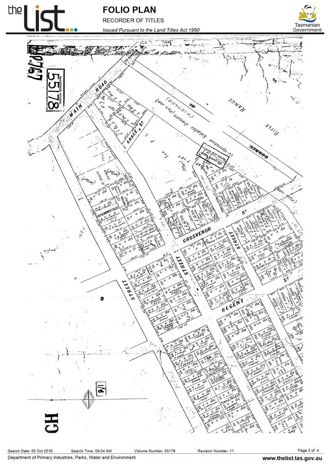
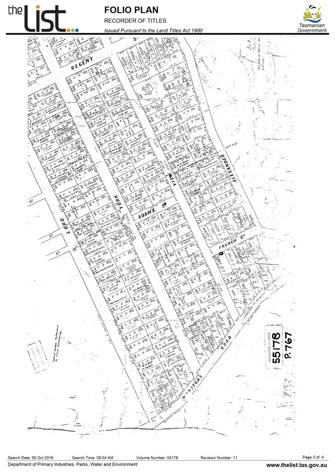
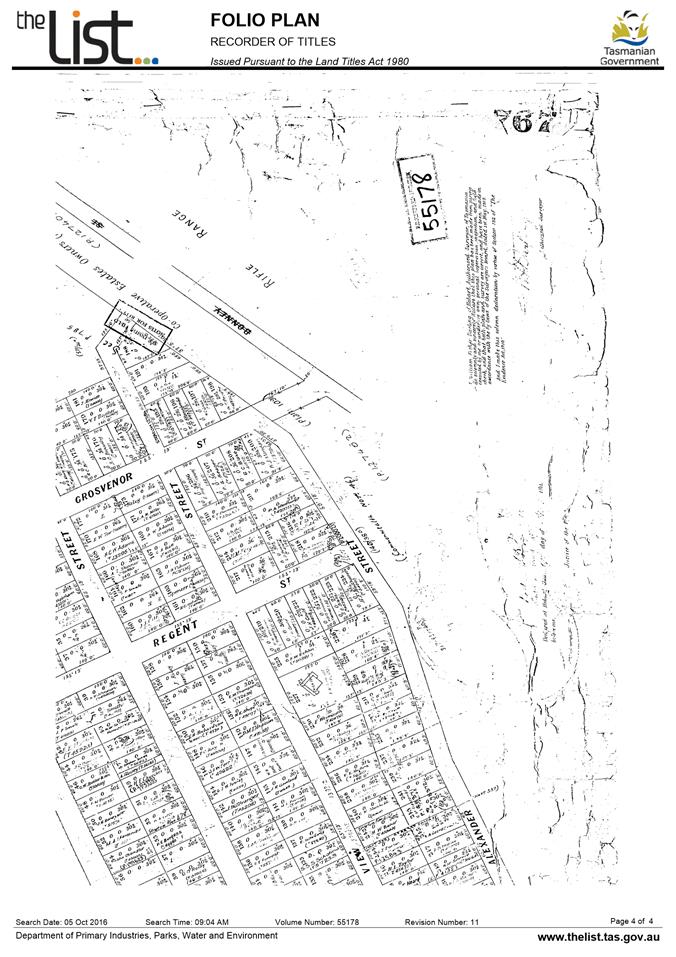
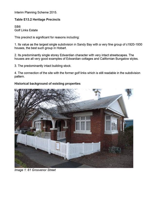
7.1.1 59 Grosvenor Street, 61 Grosvenor Street and 2 Churchill Avenue, Sandy Bay - Partial Demolition, Alterations and Multiple Dwellings
PLN-16-1068 - FILE REF: F17/17136
Address: 59 Grosvenor Street, Sandy Bay, 61 Grosvenor Street, Sandy Bay and 2 Churchill Avenue, Sandy Bay
Proposal: Partial Demolition, Alterations and Multiple Dwellings
Expiry Date: 8 March 2017
Extension of Time: Not applicable
Author: Helen Ayers
|
REcommendation That pursuant to the Hobart Interim Planning Scheme 2015, the Council approve the application for multiple dwellings at 59 Grosvenor Street, 61 Grosvenor Street and 2 Churchill Avenue, Sandy Bay for the reasons outlined in the officer’s report and a permit containing the following conditions be issued:
GEN
The use and/or development must be substantially in accordance with the documents and drawings that comprise PLN161068 59 Grosvenor Street, Sandy Bay Tas 7005 Final Planning Documents, except where modified below.
Reason for condition
To clarify the scope of the permit.
TW
The use and/or development must comply with the requirements of TasWater as detailed in the form Submission to Planning Authority Notice, Reference No. TWDA 2016/01507HCC dated 02/11/2016 as attached to the permit.
Reason for condition
To clarify the scope of the permit.
ENG 12 A construction waste management plan must be implemented throughout construction.
A construction waste management plan must be submitted and approved, prior to commencement of work on the site. The construction waste management plan must include:
• Provisions for commercial waste services for the handling, storage, transport and disposal of postconstruction solid waste and recycle bins from the development. • Provisions for the handling, transport and disposal of demolition material, including any contaminated waste and recycling opportunities.
All work required by this condition must be undertaken in accordance with the approved construction waste management plan.
Advice: Once the construction waste management plan has been approved Council will issue a condition endorsement (see general advice on how to obtain condition endorsement).
It is recommended that the developer liaise with the Council’s Cleansing and Solid Waste Unit regarding reducing, reusing and recycling materials associated with demolition on the site to minimise solid waste being directed to landfill. Further information can also be found on the Council’s website.
Reason for condition
To ensure that solid waste management from the site meets the Council’s requirements and standards.
ENG sw4
The development (including hardstand) must be drained to a piped system. The new private stormwater connection must be constructed, and any existing connections be abandoned and sealed at the owner’s expense prior to occupation.
Detailed engineering drawings must be submitted and approved, prior to commencement of work. The detailed engineering drawings must include:
a. the location of the proposed connection and all existing connections to be abandoned; b. the size and design of the connection such that it is appropriate to safely service the development; c. written permission for the works outside 59 and 61 Grosvenor St.
All work required by this condition must be undertaken in accordance with the approved engineering drawings.
Advice: Once the engineering drawing has been approved, the Council will issue a condition endorsement (see general advice on how to obtain condition endorsement).
Reason for condition
To ensure the site is drained adequately.
ENG sw7 Stormwater pre treatment and detention for stormwater discharges from the development must be installed prior to issue of a Certificate of Completion.
A stormwater management report and design must be submitted and approved, prior to commencement of works. The stormwater management report and design must:
a. be prepared by a suitably qualified engineer; b. include detailed design of the proposed treatment train, including final estimations of contaminant removal and proposed usage of harvested rainwater; c. include detailed design and supporting calculations of the detention tank, sized such that there is no increase in flows from the developed site up to 5% AEP storm events. All assumptions must be clearly stated. d. include design drawings of the detention tank showing the layout, the inlet and outlet (including long section), the overflow mechanism. e. include a Stormwater Management Summary Plan that outlines the obligations for future property owners to stormwater management, including a maintenance plan which outlines the operational and maintenance measures to check and ensure the ongoing effective operation of all systems, such as: inspection frequency; cleanout procedures; descriptions and diagrams of how the installed systems operate; details of the life of assets and replacement requirements.
The stormwater detention tank must be shown in the drawings certified by a structural engineer, and included in the documentation submitted to the Building Surveyor for assessment under the Building Act 2016.
All work required by this condition must be undertaken and maintained in accordance with the approved stormwater management report and design.
Advice: Once the stormwater management report and design has been approved the Council will issue a condition endorsement (see general advice on how to obtain condition endorsement)
Reason for condition
To avoid the possible pollution of drainage systems and natural watercourses, to comply with relevant State legislation, and to ensure the development’s stormwater system does not increase loading on shared private infrastructure.
ENG 1
The cost of repair of any damage to the Council infrastructure resulting from the implementation of this permit, must be met by the owners within 30 days of the completion of the development or as otherwise determined by the Council.
A photographic record of the Council infrastructure adjacent to the subject site must be provided to the Council prior to any commencement of works.
A photographic record of the Council’s infrastructure (e.g. existing property service connection points, roads, buildings, stormwater, footpaths, driveway crossovers and nature strips, including if any, pre existing damage) will be relied upon to establish the extent of damage caused to the Council’s infrastructure during construction. In the event that the owner/developer fails to provide to the Council a photographic record of the Council’s infrastructure, then any damage to the Council infrastructure found on completion of works will be deemed to be the responsibility of the owner.
Reason for condition
To ensure that any of the Council infrastructure and/or siterelated service connections affected by the proposal will be altered and/or reinstated at the owner’s full cost.
ENG s1
The proposed privacy screen, on drawing DA03 adjacent to the proposed parking space for 61 Grosvenor Street, shall have a maximum height of 1.2m for a distance 2.5m from the intersection of 61 Grosvenor St car parking space access and the underground car park access, prior to the commencement of use of the underground car park.
Reason for condition
To ensure sightlines between the Grosvenor St car parking and underground car parking space access are maintained, and conflict between vehicles does not occur.
ENG s2 Delineation of pavement (pavers vs concrete/bitumen) is required between dedicated pedestrian footpath and shared vehicular/pedestrian areas associated with the apartment complex.
The pavers for the proposed paved pedestrian footpath (from the apartment complex to the Right of Way), on drawing DA03 adjacent to the car parking space for 61 Grosvenor St, must not extend onto the two way vehicular access to the underground car park.
Reason for condition
To ensure a a conflict does not occur between pedestrian and vehicular users, and the access / driveway provides for safe and efficient use.
ENV 1
Sediment and erosion control measures sufficient to prevent sediment from leaving the site must be installed prior to any disturbance of the site. Sediment controls must be maintained until all areas of disturbance have been stabilized or revegetated.
Advice: For further guidance in preparing a Soil and Water Management Plan – in accordance with Fact sheet 3 Derwent Estuary Program click here. Reason for condition
To avoid the sedimentation of roads, drains, natural watercourses, Council land that could be caused by erosion and runoff from the development, and to comply with relevant State legislation.
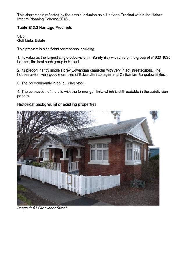
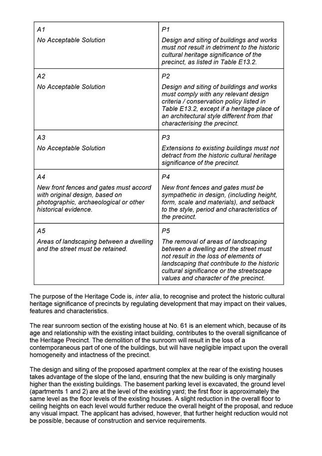
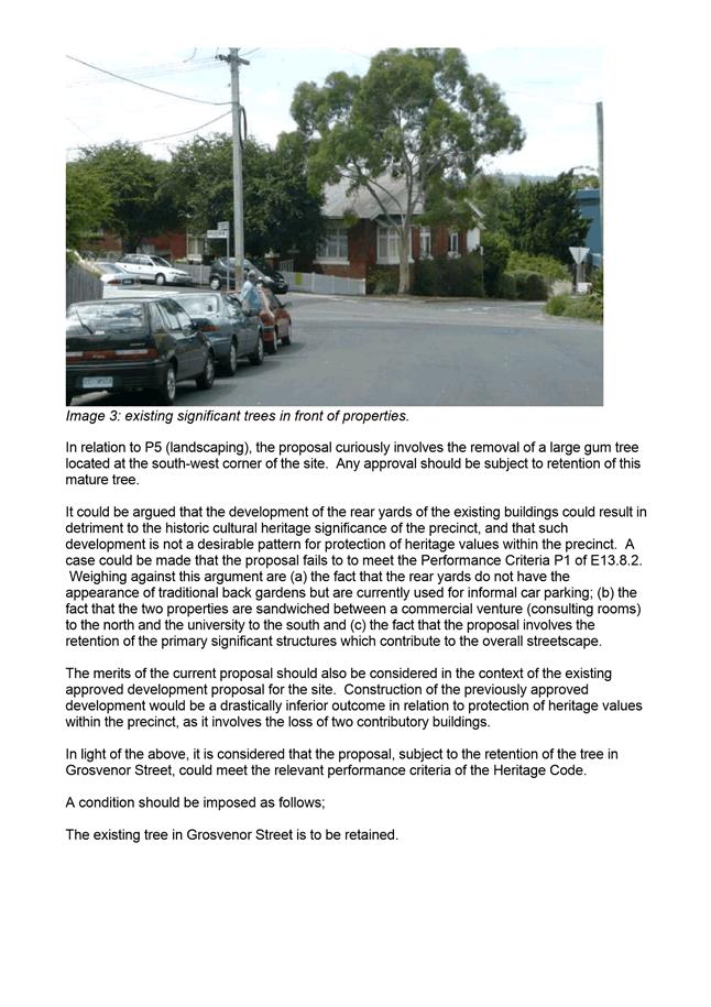
HER 18
The existing eucalyptus tree at the front of 61 Grosvenor Street must be retained and protected throughout the works and post construction.
Reason for condition
To ensure that development in a heritage precinct is undertaken in a sympathetic manner which does not cause loss of historic cultural heritage significance.
ADVICE
The following advice is provided to you to assist in the implementation of the planning permit that has been issued subject to the conditions above. The advice is not exhaustive and you must inform yourself of any other legislation, bylaws, regulations, codes or standards that will apply to your development under which you may need to obtain an approval. Visit www.hobartcity.com.au for further information.
Prior to any commencement of work on the site or commencement of use the following additional permits/approval may be required from the Hobart City Council. CONDITION ENDORSEMENT
If a condition endorsement is required by a planning condition above, you will need to submit the relevant documentation to satisfy the condition, via the Condition Endorsement Submission on Council's online eservice portal.
Once approved, the Council will respond to you via email that the condition(s) has been endorsed (satisfied). Detailed instructions can be found here.
BUILDING PERMIT
Building permit in accordance with the Building Act 2000;
http://www.hobartcity.com.au/Development/Building
PLUMBING PERMIT
Plumbing permit under the Tasmanian Plumbing Regulations 2014;
http://www.hobartcity.com.au/Development/Plumbing
STORM WATER Please note that in addition to a building and/or plumbing permit, development must be in accordance with the Hobart City Council’s Hydraulic Services By law. Click here for more information.
TITLE ADHESION
An adhesion of your titles is required because a portion of your development is across one or more title boundaries. Contact your solicitor or a registered land surveyor to initiate the process.
NOISE REGULATIONS
Click here for information with respect to noise nuisances in residential areas.
WASTE DISPOSAL
Click here for information regarding waste disposal.
DIAL BEFORE YOU DIG
Click here for dial before you dig information.
ELECTRONIC ACCESS
If you do not have access to the Council’s electronic web page, please phone the Hobart City Council's City Planning Division on 62382715 for assistance.
|
Attachment a: PLN-16-1068
- 59 GROSVENOR STREET SANDY BAY TAS 7005 - Planning Committee or Delegated
Report ⇩ ![]()
Attachment
b: PLN-16-1068
- 59 GROSVENOR STREET SANDY BAY TAS 7005 - CPC Agenda Documents - Attachment B ⇩ ![]()
Attachment
c: PLN-16-1068
- 59 GROSVENOR STREET SANDY ~S 7005 - Planning Referral Officer Report and Peer
Review (SCHO) - Attachment C_redacted ⇩ ![]()
Attachment
d: PLN-16-1068
- 59 GROSVENOR STREET SANDY BAY TAS 7005 - Supporting Documents - Attachment D
(Supporting information) ⇨
![]()
|
Item No. 7.1.1 |
Agenda (Open Portion) City Planning Committee Meeting - 27/2/2017 |
Page 16 ATTACHMENT a |

|
Agenda (Open Portion) City Planning Committee Meeting - 27/2/2017 |
Page 41 ATTACHMENT b |
|
Item No. 7.1.1 |
Agenda (Open Portion) City Planning Committee Meeting - 27/2/2017 |
Page 49 ATTACHMENT b |
|
Item No. 7.1.1 |
Agenda (Open Portion) City Planning Committee Meeting - 27/2/2017 |
Page 63 ATTACHMENT c |


|
Agenda (Open Portion) City Planning Committee Meeting |
Page 77 |
|
|
|
27/2/2017 |
|
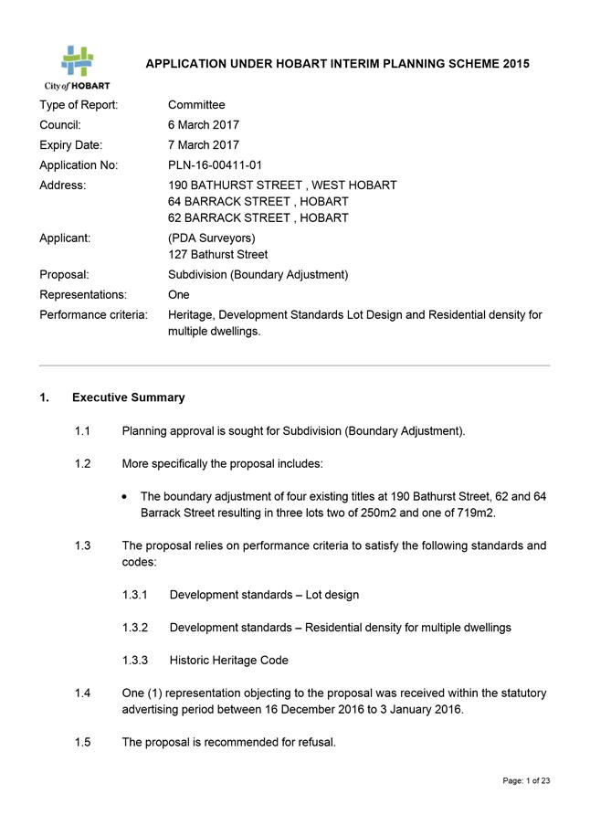
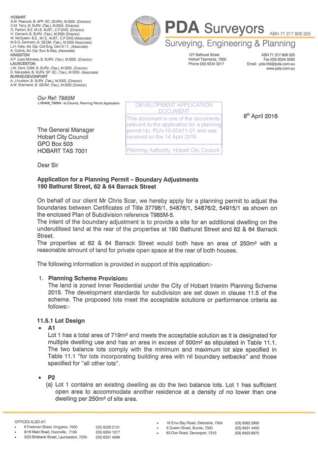
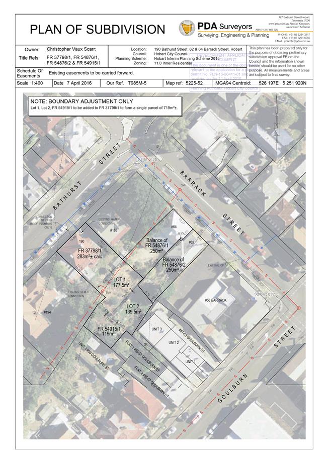
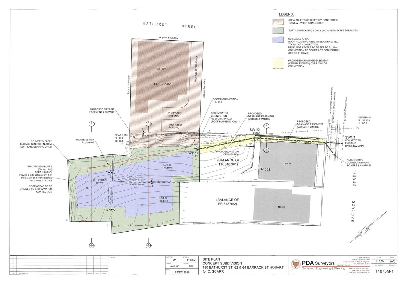
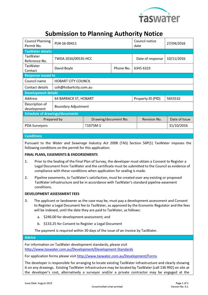
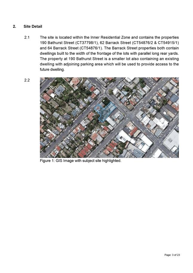
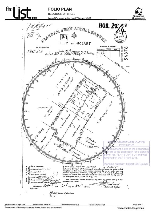
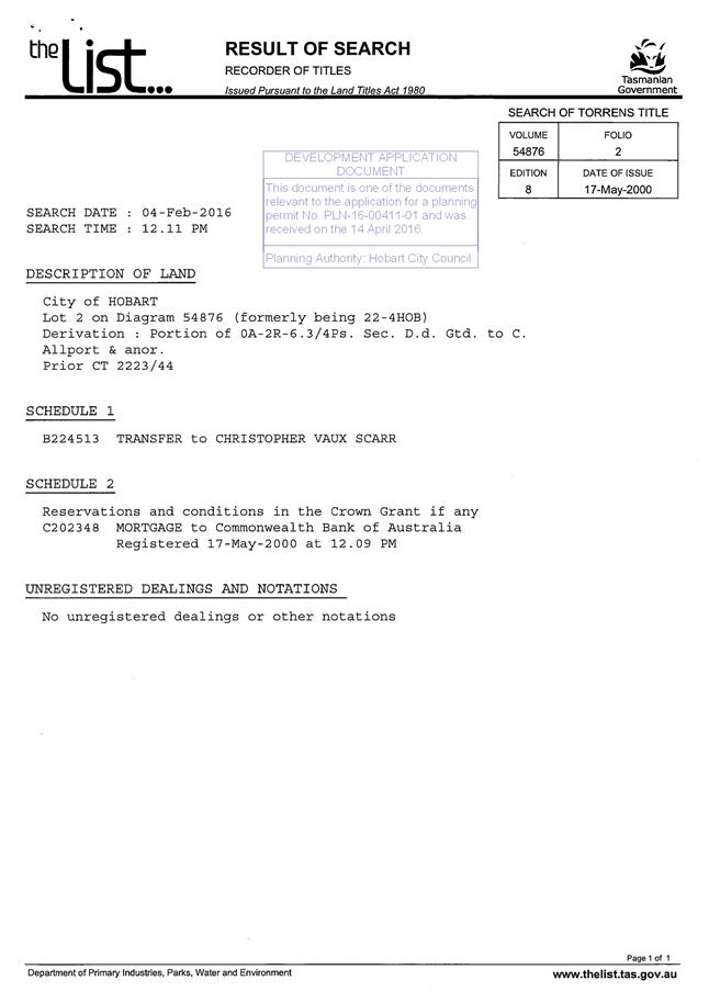
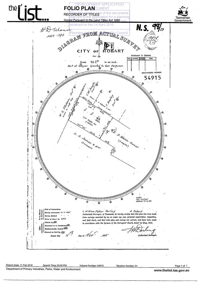
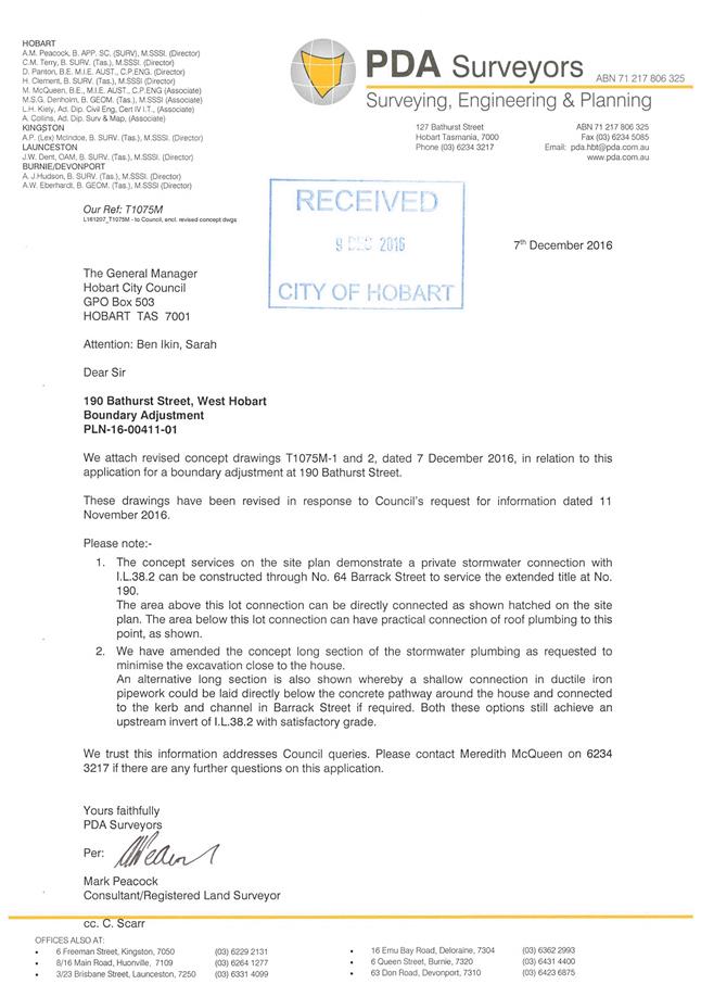
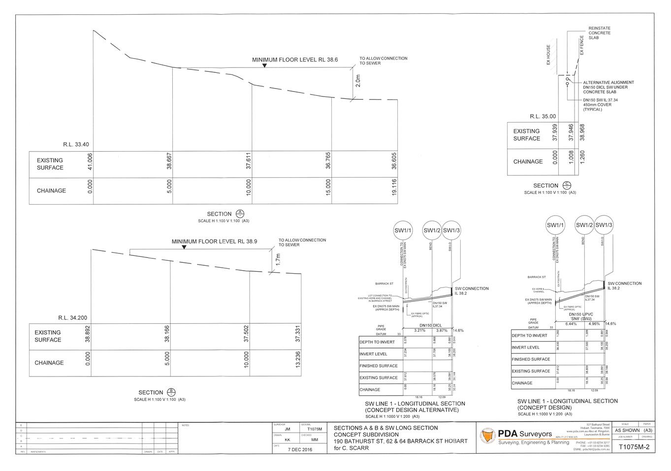
7.1.2 190 Bathurst Street, West Hobart, 64 Barrack Street, West Hobart and 62 Barrack Street, West Hobart - Subdivision (Boundary Adjustment)
PLN-16-00411-01 - FILE REF: F17/17171; PLN-16-00411-01
Address: 190 Bathurst Street, West Hobart, 64 Barrack Street, Hobart and 62 Barrack Street, Hobart
Proposal: Subdivision (Boundary Adjustment)
Expiry Date: 7 March 2017
Extension of Time: Not applicable
Author: Tristan Widdowson
|
REcommendation That pursuant to the Hobart Interim Planning Scheme 2015, the Council refuse the application for Subdivision (Boundary Adjustment) at 190 Bathurst Street, 62 Barrack Street and 64 Barrack Street, West Hobart for the following reasons: 1. The proposed boundary adjustment fails to meet Clause E.13.7.3 P1 (c) of the Hobart Interim Planning Scheme 2015 because it provides a lot size and configuration which would allow unsympathetic residential development to the rear of heritage listed places 64 Barrack Street and 190 Bathurst Street. 2. The proposed boundary adjustment fails to meet Clause E.13.8.3 P1 (d) of the Hobart Interim Planning Scheme 2015 because it will lead to an increased likelihood of future residential development incompatible with the cultural heritage significance of the Inner Hillside Housing/Bathurst Street Heritage Precinct (WH5).
|
Attachment
a: PLN-16-00411-01
- 190 BATHURST STREET WEST HOBART TAS 7000 - Planning Committee or Delegated
Report ⇩ ![]()
Attachment
b: PLN-16-00411-01
- 190 Bathurst Street - HOBART - 190 Bathurst Street - CPC Agenda Documents ⇩ ![]()
|
Item No. 7.1.2 |
Agenda (Open Portion) City Planning Committee Meeting - 27/2/2017 |
Page 79 ATTACHMENT a |
|
Agenda (Open Portion) City Planning Committee Meeting - 27/2/2017 |
Page 102 ATTACHMENT b |
|
Item No. 7.1.2 |
Agenda (Open Portion) City Planning Committee Meeting - 27/2/2017 |
Page 104 ATTACHMENT b |
|
Item No. 7.1.2 |
Agenda (Open Portion) City Planning Committee Meeting - 27/2/2017 |
Page 106 ATTACHMENT b |
|
Item No. 7.1.2 |
Agenda (Open Portion) City Planning Committee Meeting - 27/2/2017 |
Page 115 ATTACHMENT b |
|
Item No. 7.1.2 |
Agenda (Open Portion) City Planning Committee Meeting - 27/2/2017 |
Page 117 ATTACHMENT b |
|
Agenda (Open Portion) City Planning Committee Meeting |
Page 119 |
|
|
|
27/2/2017 |
|
8 Reports
8.1 Review of Interim Planning Directive No. 1 (Bushfire-Prone Areas Code) and Related Amendments to the Building Regulations 2014
File Ref: F17/8924; 15/97
Report of the Manager Planning Policy and Heritage of 1 March 2017 and attachments.
Delegation: Committee
|
Item No. 8.1 |
Agenda (Open Portion) City Planning Committee Meeting |
Page 121 |
|
|
27/2/2017 |
|
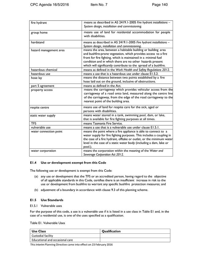
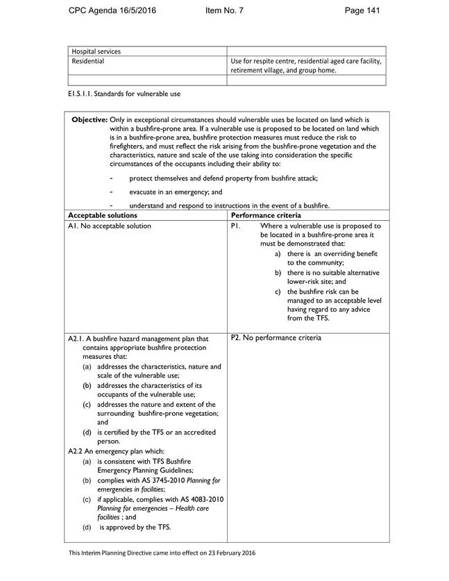
REPORT TITLE: Review of Interim Planning Directive No. 1 (Bushfire-Prone Areas Code) and Related Amendments to the Building Regulations 2014
REPORT PROVIDED BY: Manager Planning Policy and Heritage
1. Report Purpose and Community Benefit
1.1. This report concerns the operation of the Bushfire-Prone Areas Code, and the provisions of the Building Regulations 2014 applying to bushfire-prone areas (that were amended at the time Interim Planning Directive No. 1 was issued).
1.2. Effective operation of the Bushfire Prone Areas Code and the Building Regulations 2014 benefits the community by providing for a safer environment.
2. Report Summary
2.1. In May 2016 Council requested that officers provide a report to the City Planning Committee in six months regarding the operation of the new Bushfire-Prone Areas Code in the City of Hobart Planning Scheme 2015 introduced under Planning Directive No. 1.
2.2. Officers have carried out a review of the operation of the new Bushfire-Prone Areas Code, and the Building Regulations 2014 which were amended in association with Planning Directive No. 1. This included an audit of building applications in bushfire-prone areas, to determine compliance with the amended building regulations and also with the vegetation clearing requirements of the Biodiversity Code in the Hobart Interim Planning Scheme 2015.
2.3. Some instances of potential non-compliance with the Building Regulations 2014 were detected, however these were relatively few and in some cases subjective. They were also generally minor in nature, involved low-risk situations and commonly represent difficulties in the interpretation of the regulations and associated guidelines and the complexity of the interaction between current and previous versions of the Building Regulations 2014 and the Bushfire-Prone Areas Code.
2.4. No instances of significant clearing of native vegetation without obtaining any necessary planning approval were identified, however it is considered difficult to assess whether this is likely to be significant ongoing issue after such a relatively short period of time since the changes have occurred. It is therefore proposed to provide a further audit and subsequent report to the Council in a further twelve months time.
|
That: 1. Council officers continue to monitor compliance with the bushfire-prone area regulations of the Building Regulations 2016 and the vegetation clearing requirements of the Hobart Interim Planning Scheme 2015; and 2. A further report be provided to Council in 12 months’ time.
|
4. Background
4.1. At its meeting of 23 May 2016 Council resolved as follows:
4.1.1. That the Council endorse a representation from the Director City Planning to the Tasmanian Planning Commission concerning Interim Planning Directive No. 1 – Bushfire-Prone Areas Code; and
4.1.2. That officers provide a report to the City Planning Committee in six months regarding the operation of the Bushfire-Prone Areas Code.
4.2. Interim Planning Directive No. 1 (‘IPD1’), which took effect on 23 February 2016, introduced a new Bushfire-Prone Areas Code (‘Bushfire Code’) into the Hobart Interim Planning Scheme 2015. The Directive has effect for a 12-month period.
4.3. The key change to the Bushfire Code was the exclusion of habitable buildings from the code’s application. Similar standards for residential habitable buildings in bushfire-prone areas were introduced at that time under the Building Regulations 2014 (‘the regulations’).
4.4. The current Bushfire Code in the Hobart Interim Planning Scheme 2015 now only applies to planning applications for subdivision, vulnerable uses and hazard uses in bushfire-prone areas.
4.5. The Minister for Planning and Local Government requested that the Tasmanian Planning Commission assess IPD1. The Tasmanian Planning Commission sought representations on the Directive.
4.6. The Director City Planning made a representation to the Tasmanian Planning Commission in May 2016. A copy of the representation made to the Tasmanian Planning Commission and the report to the City Planning Committee seeking endorsement of the representation are attached as Attachment A. The representation indicated that:
4.6.1. the transfer of regulation for residential buildings in bushfire-prone areas from the planning system to the building system was supported; and
4.6.2. the retention of regulation of subdivision, vulnerable and hazardous uses within the planning system, was considered appropriate; and
4.6.3. the more detailed and clearer specifications with regard to access requirements and water supply were an improvement over the previous version of the Bushfire Code and regulations.
4.6 The representation also indicated that the changes may have unintended consequences with regard to vegetation clearing and management in that applicants may not be aware of the exact requirements for bushfire hazard management areas under the regulations at the time of making a planning application (as determined by an accredited bushfire hazard practitioner and included in a certified bushfire hazard management plan) potentially leading to:
4.6.1 failure to apply for any necessary planning approval for vegetation clearing or management that may in turn lead to;
4.6.2 vegetation clearing to meet the requirements of the regulations without obtaining necessary planning approval; and/or
4.6.3 developers needing to obtain further planning approval (new applications or amendments) after the initial planning application is made and building permit has been granted.
4.7 A Tasmanian Planning Commission hearing for IPD1, together with the Bushfire-Prone Areas Code in the State Planning Provisions of the Draft Tasmanian Planning Scheme, was held in October 2016. An officer of the Council made a representation at that hearing raising the issues above as well as other matters.
4.8 The Tasmanian Planning Commission’s assessment of IPD1 has not been completed. It is expected that the Commission’s assessment will be completed as part of its consideration of the State Planning Provisions in the Draft Tasmanian Planning Scheme. It is expected that the Minister will issue a new directive requiring insertion of the Bushfire-Prone Areas Code approved for the State Planning Provisions into the Hobart Interim Planning Scheme 2015 prior to the expiry of IPD5 on 22 February 2016.
4.9 It should also be noted that the Building Regulations 2016 which came into effect on 1 January 2017, including new regulations for development in bushfire-prone areas, have now replaced the Building Regulations 2014. While an in-depth review of the how requirements for development in bushfire-prone areas are affected by the introduction of the Building Regulations 2016 has not been undertaken, a brief review suggests there have been no major changes in application scope or key requirements. The analysis provided in this report is therefore expected to be largely applicable to the Building Regulations 2016 as well.
5. Proposal and Implementation
5.1. Implementation of the new Bushfire Code and amended regulations has generally been easier for Council than the previous system because:
5.1.1. the Bushfire Code has less extensive application and improvements in the clarity of requirements; and
5.1.2. implementation of the new requirements under the regulations was largely the responsibility of private building surveyors.
5.2. However, to help minimise the potential for unlawful vegetation clearing or for planning permit applicants to seek additional planning approval there has been a need to proactively advise applicants to consider and determine vegetation clearing requirements under the former regulations at the time of making a planning application. This has not been particularly onerous on Council officers, however Council officers have, at times, been required to accept that information about proposed vegetation clearing is correct without necessarily having the supporting documentation as evidence of the accuracy of this information (e.g. a certified bushfire hazard management plan).
5.3. In addition, the opportunity to provide this advice to applicants has generally been limited to situations where planning approval for the building itself is required, and there are a considerable number of dwelling developments that do not require a planning permit under the Hobart Interim Planning Scheme 2015.
5.4. There is also a need for Council officers to sometimes request the level of construction of a building under Australian Standard AS3959: Construction of Buildings in Bushfire Prone Areas for a development which is not subject to the Bushfire Code to determine compliance with relevant standards under the Biodiversity Code of the Hobart Interim Planning Scheme 2015. However, there has been no significant resistance on the part of developers to provide such information.
5.5. While the new system has only been in place for less than one year, and there is often a considerable delay between developments receiving planning approval and receiving building approval and/or acting upon that building approval, officers are not aware of any instances where:
5.5.1. vegetation clearing has definitely occurred without planning approval due to vegetation clearing requirements only becoming apparent to developers at the building approvals stage; or
5.5.2. additional planning approval has been sought due to vegetation clearing requirements only becoming apparent to developers at the building approvals stage.
5.6. This suggests that the proactive measures being employed by the Council’s planning officers, potentially together with good advice being provided by development practitioners may generally have been effective in avoiding these potential scenarios.
5.7. The critical issue for the changes to the system is how well the requirements of the regulations have been implemented. To help to determine this, twenty seven building applications in bushfire-prone areas from 2016 were audited to determine whether the regulations had been correctly implemented. Attention was also given to whether planning approval had been received for any proposed vegetation clearing.
5.8. The building applications included ten for new dwellings and seventeen for additions, alterations and/or outbuildings. One of the applications for additions and alterations also included a change of use to a ‘vulnerable use’ (visitor accommodation) under the regulations.
5.9. With regard to the regulations, eight of the ten dwelling applications and fourteen of the nineteen extension/alterations/outbuilding applications were deemed generally compliant.
5.10. Two dwelling and two extension/alterations/outbuilding applications were considered dubious in terms of compliance with the regulations as indicated below:
5.10.1. For one house extension and one new dwelling application, the sites were indicated as not being within a bushfire-prone area on the basis of the surrounding vegetation, but an analysis of aerial photography suggests that the sites perhaps should have been considered bushfire-prone. It is probably arguable either way for these sites however, and a site inspection of the surrounding vegetation would be required to make a definitive call.
5.10.2. For another house application, the site was deemed not to be within a bushfire-prone area as some of the vegetation was indicated as meeting the definition of ‘managed land’ (and therefore no bushfire-prone vegetation) due the zoning of the surrounding land (based on a Tasmania Fire Service bushfire planning advisory note). However, this exclusion on the basis of zoning is thought to be only applicable for the purposes of assessment under the Bushfire Code, not the regulations.
5.10.3. For another extension application, a determination of ‘insufficient increase in risk’ to meet an exemption from the previous version of the Bushfire Code (introduced by Planning Directive No. 5) was relied upon to meet an exemption under the regulations where ‘insufficient increase in risk’ is certified. This was largely a non-compliance in terms of documentation and it is likely that the bushfire practitioner would have issued a similar certification to satisfy the regulations.
5.11. Three building applications for extensions/additions/outbuildings were assessed as being definitely non-compliant with the regulations. Two applications were for decks and one was for a carport where the regulations relating to bushfire-prone areas did not appear to have been considered at all (but should have been).
5.12. While the majority of these building applications did not involve proposals for vegetation clearing that would have required planning approval, two applications did involve hazard management areas where planning approval may have been required but was not obtained. Both these hazard management areas are likely to have involved fairly minimal clearance of vegetation of low biodiversity significance and would most likely have been ‘permitted’ under the Biodiversity Code if assessment was required and obtained.
5.13. Overall, given that the system is fairly new, has been changing frequently over the previous five years, is complex and sometimes unclear in terms of the relationship between processes under the planning system and building system, there was found to be a reasonable level of compliance with the regulations. Importantly, the higher risk scenarios involving more significant assets and higher bushfire risk sites generally showed a high level of compliance.
5.14. Given that the system of planning and building requirements in bushfire-prone areas is relatively new, complex and dynamic, it is expected that the level of compliance with the building regulations will increase over time, and that the risk of unlawful impacts upon native vegetation will decrease.
5.15. Another potential issue with the new system has become apparent since its introduction. In a small number of situations there will be a need to establish and maintain bushfire hazard management areas on property external to the property upon which a building is to be constructed, and it is not apparent what mechanism is in place under the building approvals system to ensure that the hazard management areas on external properties will be able to be legally maintained if under other ownership.
5.16. This is dealt with under the planning system through the use of Part 5 Agreements under the Land Use Planning and Approvals Act 1993, however no similar mechanism appears to exist under the Building Act or regulations. It may be that other forms of private legal agreements can be effectively used to ensure the ongoing legal right to access external properties and maintain hazard management areas.
6. Strategic Planning and Policy Considerations
6.1. The new Bushfire Code and changes to the Building Regulations 2014 appears to have had minimal impact on the achievement of the strategic objectives of the Capital City Strategic Plan 2015-2025 particularly in relation to Goal 2 Urban Management
7. Financial Implications
7.1. Funding Source and Impact on Current Year Operating Result
7.1.1. The changes to the bushfire regulation system has had no impact upon the current year operating result.
8. Legal, Risk and Legislative Considerations
8.1. There is likely to have been a reduction in Council’s exposure to liability with regard to the risk of incorrect assessment of planning applications under the Bushfire Code, given the reduced applicability of the Bushfire Code, and because the legal responsibility for determining compliance with building regulations largely rests with the building surveyor or accredited bushfire hazard practitioner.
8.2. Any reduction in exposure to potential liability is likely to be minor however, as Planning Authorities were (and are) bound under the Land Use Planning and Approvals Act 1993 to accept certified bushfire hazard management plans and because the more-significant liability risk lies in relation to the ongoing enforcement of bushfire hazard management plans that are required to be complied with under planning and building permits.
8.3. The report to the City Planning Committee with regard to Council’s representation also indicated that the requirement for self-certification of bushfire plan maintenance required under the regulations would be likely to help to reduce Council’s exposure to liability resulting from any lack of enforcement of bushfire plans, however these requirements only applied under the Building Regulations 2014 to public buildings which were a small minority of buildings subject to the bushfire-prone area requirements of the regulations (mostly buildings for ‘vulnerable use’), so self-certification was only a requirement for a small proportion of the building subject to the regulations for bushfire-prone areas.
9. Environmental Considerations
9.1. Based on officer experience and the small audit conducted, the introduction of IPD1 and the amended Building Regulations 2014 does not appear to have resulted in any significant increase in the unlawful clearing of native vegetation. However, only a relatively-small number of developments in areas subject to the Biodiversity Code where new hazard management areas requiring clearance of native vegetation have been approved and progressed to the stage of actual development under the new system. It may therefore be appropriate to carry out similar audits in the future.
10. Social and Customer Considerations
10.1. There has been minimal negative feedback from planning permit applicants relating to requests for details of proposed vegetation clearing needed to satisfy the Building Regulations 2014.
10.2. There have been no situations where applicants have had to seek further planning approval due to being unaware of vegetation clearing requirements to meet the requirements of the Building Regulations 2014.
11. Community and Stakeholder Engagement
11.1. Information has been placed on the Council’s website about the need to consider requirements for vegetation clearing to meet the Building Regulations 2016 at the planning application stage.
12. Delegation
12.1. No delegations are relevant.
As signatory to this report, I certify that, pursuant to Section 55(1) of the Local Government Act 1993, I hold no interest, as referred to in Section 49 of the Local Government Act 1993, in matters contained in this report.
|
James McIlhenny Manager Planning Policy and Heritage |
|
Date: 1 March 2017
File Reference: F17/8924; 15/97
Attachment a: Bushfire
Code Representation Report ⇩ ![]()
|
Item No. 8.1 |
Agenda (Open Portion) City Planning Committee Meeting - 27/2/2017 |
Page 130 ATTACHMENT a |
|
Agenda (Open Portion) City Planning Committee Meeting |
Page 168 |
|
|
|
27/2/2017 |
|
8.2 Delegated Decisions Report (Planning)
File Ref: F17/16491; 16/117
Report of the Director City Planning of 22 February 2017 and attachments.
Delegation: Committee
|
Item No. 8.2 |
Agenda (Open Portion) City Planning Committee Meeting |
Page 169 |
|
|
27/2/2017 |
|

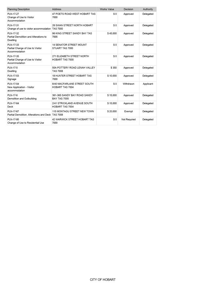
Memorandum: City Planning Committee
Delegated Decisions Report (Planning)
Attached is the delegated planning decisions report for the period 3 February until 19 February 2017.
|
That: 1. The information be received and noted.
|
As signatory to this report, I certify that, pursuant to Section 55(1) of the Local Government Act 1993, I hold no interest, as referred to in Section 49 of the Local Government Act 1993, in matters contained in this report.
|
Neil Noye Director City Planning |
|
Date: 22 February 2017
File Reference: F17/16491; 16/117
Attachment a: Delegated
Decisions Report (Planning) ⇩ ![]()
|
Item No. 8.2 |
Agenda (Open Portion) City Planning Committee Meeting - 27/2/2017 |
Page 171 ATTACHMENT a |
|
Agenda (Open Portion) City Planning Committee Meeting |
Page 172 |
|
|
|
27/2/2017 |
|
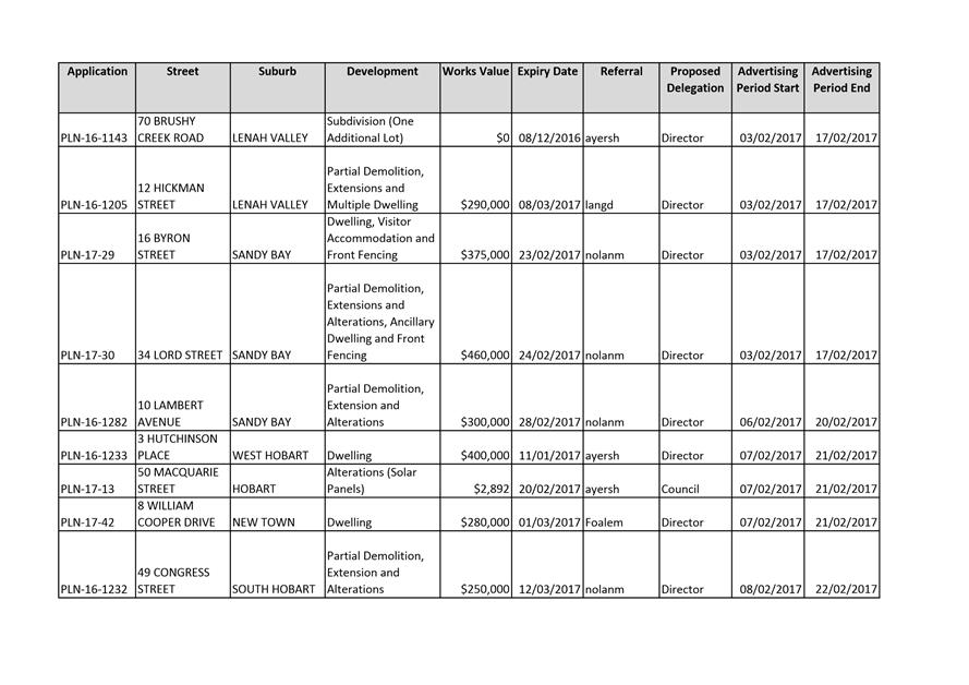
8.3 City Planning - Advertising List
File Ref: F17/17081; 16/117
Report of the Director City Planning of 21 February 2017 and attachments.
Delegation: Committee
|
Item No. 8.3 |
Agenda (Open Portion) City Planning Committee Meeting |
Page 173 |
|
|
27/2/2017 |
|

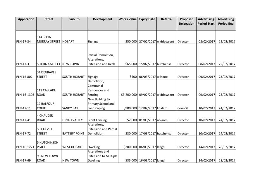
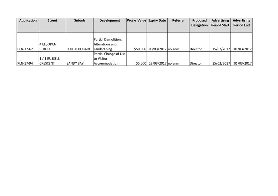
Memorandum: City Planning Committee
City Planning - Advertising List
Attached is the advertising list for the period 3 February until 16 February 2017.
|
That: 1. The information be received and noted.
|
As signatory to this report, I certify that, pursuant to Section 55(1) of the Local Government Act 1993, I hold no interest, as referred to in Section 49 of the Local Government Act 1993, in matters contained in this report.
|
Neil Noye Director City Planning |
|
Date: 21 February 2017
File Reference: F17/17081; 16/117
Attachment a: City
Planning Advertising List ⇩ ![]()
|
Item No. 8.3 |
Agenda (Open Portion) City Planning Committee Meeting - 27/2/2017 |
Page 175 ATTACHMENT a |
|
Agenda (Open Portion) City Planning Committee Meeting |
Page 178 |
|
|
|
27/2/2017 |
|
Regulation 29(3) Local Government
(Meeting Procedures) Regulations 2015.
File Ref: 13-1-10
The General Manager reports:-
“In accordance with the procedures approved in respect to Questions Without Notice, the following responses to questions taken on notice are provided to the Committee for information.
The Committee is reminded that in accordance with Regulation 29(3) of the Local Government (Meeting Procedures) Regulations 2015, the Chairman is not to allow discussion or debate on either the question or the response.”
9.1 Matters to be considered regarding subdivision applications
File Ref: F16/139462; 13-1-10
Report of the Director City Planning of 27 February 2017.
9.2 Impact of new Building Act and Regulations
File Ref: F17/4800; 13-1-10
Report of the Director City Planning of 27 February 2017.
Delegation: Committee
|
That the information be received and noted.
|
|
Item No. 9.1 |
Agenda (Open Portion) City Planning Committee Meeting |
Page 180 |
|
|
27/2/2017 |
|
Memorandum: Lord Mayor
Deputy Lord Mayor
Aldermen
Response to Question Without Notice
Matters to be considered regarding subdivision applications
|
Meeting: City Planning Committee
|
Meeting date: 16 January 2017
|
|
Raised by: Alderman Denison |
|
Question:
Can Council consider the location of easements and rights of ways in the future as part of subdivision applications, to facilitate access to sunlight and reduce impacts on privacy for neighbouring properties?
Response:
The standard for subdivision lot design in the General Residential Zone in 10.6.1 is as follows:
|
Acceptable Solutions |
Performance Criteria |
||||
|
A1
The size of each lot must comply with the minimum and maximum lot sizes specified in Table 10.1, except if for public open space, a riparian or littoral reserve or utilities. |
P1
The size of each lot must satisfy all of the following:
|
|
A2
The design of each lot must provide a minimum building area that is rectangular in shape and complies with all of the following, except if for public open space, a riparian or littoral reserve or utilities:
|
P2
The design of each lot must contain a building area able to satisfy all of the following:
|
||||||||||||||||||||||||||||
|
A3
The frontage for each lot must comply with the minimum and maximum frontage specified in Table 10.2, except if for public open space, a riparian or littoral reserve or utilities or if an internal lot. |
P3
The frontage of each lot must satisfy all of the following:
|
|
A4
No lot is an internal lot. |
P4
An internal lot must satisfy all of the following:
|
||||||||||||||||||||
|
A5
Subdivision is for no more than 3 lots. |
P5
Arrangement and provision of lots must satisfy all of the following;
|
The above standards do require a building area to be clear of any easements but does not give the ability to specify that the placement of easements be in a particular location.
However, if the subdivision involves an internal lot clause 10.6.1 P4 (e) allows consideration of the impact on the amenity of neighbouring land by subsequent use or development. This may provide some scope to consider the location of easements and rights of ways where it could be reasonably assumed that there placement may result in unreasonable impact on adjacent residential amenity.
.
As signatory to this report, I certify that, pursuant to Section 55(1) of the Local Government Act 1993, I hold no interest, as referred to in Section 49 of the Local Government Act 1993, in matters contained in this report.
|
Neil Noye Director City Planning |
|
Date: 22 February 2017
File Reference: F16/139462; 13-1-10
|
Item No. 9.2 |
Agenda (Open Portion) City Planning Committee Meeting |
Page 185 |
|
|
27/2/2017 |
|
Memorandum: Lord Mayor
Deputy Lord Mayor
Aldermen
Response to Question Without Notice
Impact of new Building Act and Regulations
|
Meeting: City Planning Committee
|
Meeting date: 16 January 2017
|
|
Raised by: Alderman Briscoe |
|
Question:
What implications are there for the planning department as a result of the new rules with respect to building permits?
Response:
The changes to the Building Act were reported to the City Planning Committee at its meeting of 12 December 2016. As outlined within this report it is expected that the reduction in the number of building applications is likely to result in some modest reduction in administrative tasks and associated revenue. However, we may see an increase in compliance related investigations as building work is commenced potentially without the necessary planning and or building approvals.
The City Planning Division is monitoring the implementation of the new Act and will modify procedures, practices and resources as appropriate to deliver on the Council’s statutory responsibilities. The Division will also ensure industry and the wider public are informed of their obligations concerning the new Act as appropriate should there be some deficiency in the State Government’s attempt to communicate the changes to date.
As signatory to this report, I certify that, pursuant to Section 55(1) of the Local Government Act 1993, I hold no interest, as referred to in Section 49 of the Local Government Act 1993, in matters contained in this report.
|
Neil Noye Director City Planning |
|
Date: 9 February 2017
File Reference: F17/4800; 13-1-10
|
|
Agenda (Open Portion) City Planning Committee Meeting |
Page 186 |
|
|
27/2/2017 |
|
Section 29 of the Local Government (Meeting Procedures) Regulations 2015.
File Ref: 13-1-10
An Alderman may ask a question without notice of the Chairman, another Alderman, the General Manager or the General Manager’s representative, in line with the following procedures:
1. The Chairman will refuse to accept a question without notice if it does not relate to the Terms of Reference of the Council committee at which it is asked.
2. In putting a question without notice, an Alderman must not:
(i) offer an argument or opinion; or
(ii) draw any inferences or make any imputations – except so far as may be necessary to explain the question.
3. The Chairman must not permit any debate of a question without notice or its answer.
4. The Chairman, Aldermen, General Manager or General Manager’s representative who is asked a question may decline to answer the question, if in the opinion of the respondent it is considered inappropriate due to its being unclear, insulting or improper.
5. The Chairman may require a question to be put in writing.
6. Where a question without notice is asked and answered at a meeting, both the question and the response will be recorded in the minutes of that meeting.
7. Where a response is not able to be provided at the meeting, the question will be taken on notice and
(i) the minutes of the meeting at which the question is asked will record the question and the fact that it has been taken on notice.
(ii) a written response will be provided to all Aldermen, at the appropriate time.
(iii) upon the answer to the question being circulated to Aldermen, both the question and the answer will be listed on the agenda for the next available ordinary meeting of the committee at which it was asked, where it will be listed for noting purposes only.
|
|
Agenda (Open Portion) City Planning Committee Meeting |
Page 187 |
|
|
27/2/2017 |
|