City
of hobart
AGENDA
City Planning Committee Meeting
Open Portion
Monday, 12 December 2016
at 5:00 pm
Lady Osborne Room, Town Hall
City
of hobart
AGENDA
City Planning Committee Meeting
Open Portion
Monday, 12 December 2016
at 5:00 pm
Lady Osborne Room, Town Hall
THE MISSION
Our mission is to ensure good governance of our capital City.
THE VALUES
The Council is:
|
about people |
We value people – our community, our customers and colleagues. |
|
professional |
We take pride in our work. |
|
enterprising |
We look for ways to create value. |
|
responsive |
We’re accessible and focused on service. |
|
inclusive |
We respect diversity in people and ideas. |
|
making a difference |
We recognise that everything we do shapes Hobart’s future. |
|
|
Agenda (Open Portion) City Planning Committee Meeting |
Page 3 |
|
|
12/12/2016 |
|
Business listed on the agenda is to be conducted in the order in which it is set out, unless the committee by simple majority determines otherwise.
APOLOGIES AND LEAVE OF ABSENCE
1. Co-Option of a Committee Member in the event of a vacancy
3. Consideration of Supplementary Items
4. Indications of Pecuniary and Conflicts of Interest.
6. Planning Authority Items - Consideration of Items With Deputations
7. Committee Acting as Planning Authority
7.1 Applications under the Hobart Interim Planning Scheme 2015
8.1 Infill Development Pilot Project
8.2 Battery Point Advisory Committee - Re-appointment of Expiring Memberships 2016
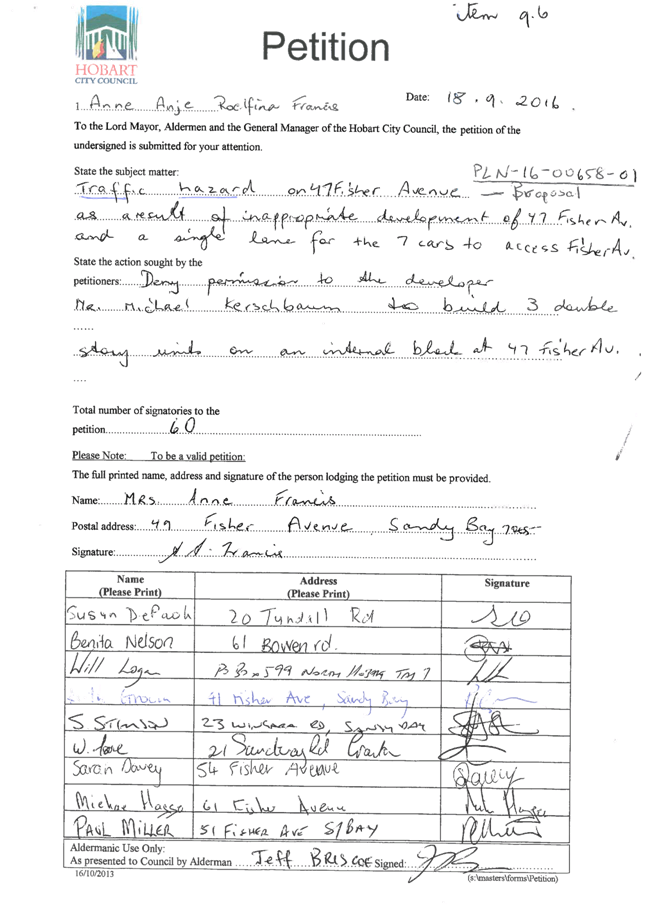
8.3 Petition – Traffic Hazard - 47 Fisher Avenue, Sandy Bay - PLN-16-00658-01
8.4 City Planning - Advertising List
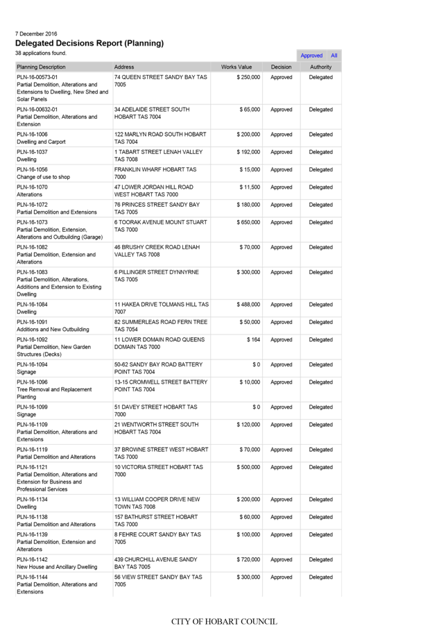
8.5 Delegated Decisions Report (Planning)
10. Closed Portion Of The Meeting
|
|
Agenda (Open Portion) City Planning Committee Meeting |
Page 5 |
|
|
12/12/2016 |
|
City Planning Committee Meeting (Open Portion) held Monday, 12 December 2016 at 5:00 pm in the Lady Osborne Room, Town Hall.
|
COMMITTEE MEMBERS Briscoe (Chairman) Ruzicka Burnet Denison
ALDERMEN Lord Mayor Hickey Deputy Lord Mayor Christie Zucco Sexton Cocker Thomas Reynolds Harvey |
Apologies: Nil
Leave of Absence: Nil
|
|
The minutes of the Open Portion of the City Planning Committee meeting held on Monday, 28 November 2016, are submitted for confirming as an accurate record.
|
Ref: Part 2, Regulation 8(6) of the Local Government (Meeting Procedures) Regulations 2015.
|
That the Committee resolve to deal with any supplementary items not appearing on the agenda, as reported by the General Manager.
|
Ref: Part 2, Regulation 8(7) of the Local Government (Meeting Procedures) Regulations 2015.
Aldermen are requested to indicate where they may have any pecuniary or conflict of interest in respect to any matter appearing on the agenda, or any supplementary item to the agenda, which the committee has resolved to deal with.
Regulation 15 of the Local Government (Meeting Procedures) Regulations 2015.
A committee may close a part of a meeting to the public where a matter to be discussed falls within 15(2) of the above regulations.
In the event that the committee transfer an item to the closed portion, the reasons for doing so should be stated.
Are there any items which should be transferred from this agenda to the closed portion of the agenda, or from the closed to the open portion of the agenda?
In accordance with the requirements of Part 2 Regulation 8(3) of the Local Government (Meeting Procedures) Regulations 2015, the General Manager is to arrange the agenda so that the planning authority items are sequential.
In accordance with Part 2 Regulation 8(4) of the Local Government (Meeting Procedures) Regulations 2015, the Committee by simple majority may change the order of any of the items listed on the agenda, but in the case of planning items they must still be considered sequentially – in other words they still have to be dealt with as a single group on the agenda.
Where deputations are to be received in respect to planning items, past practice has been to move consideration of these items to the beginning of the meeting.
RECOMMENDATION
That in accordance with Regulation 8(4) of the Local Government (Meeting Procedures) Regulations 2015, the Committee resolve to deal with any items which have deputations by members of the public regarding any planning matter listed on the agenda, to be taken out of sequence in order to deal with deputations at the beginning of the meeting.
|
|
Agenda (Open Portion) City Planning Committee Meeting |
Page 7 |
|
|
12/12/2016 |
|
In accordance with the provisions of Part 2 Regulation 25 of the Local Government (Meeting Procedures) Regulations 2015, the intention of the Committee to act as a planning authority pursuant to the Land Use Planning and Approvals Act 1993 is to be noted.
In accordance with Regulation 25, the Committee will act as a planning authority in respect to those matters appearing under this heading on the agenda, inclusive of any supplementary items.
The Committee is reminded that in order to comply with Regulation 25(2), the General Manager is to ensure that the reasons for a decision by a Council or Council Committee acting as a planning authority are recorded in the minutes.
|
Agenda (Open Portion) City Planning Committee Meeting |
Page 8 |
|
|
|
12/12/2016 |
|
7.1 Applications under the Hobart Interim Planning Scheme 2015
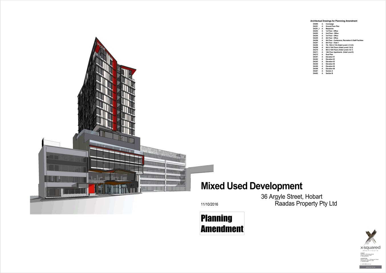
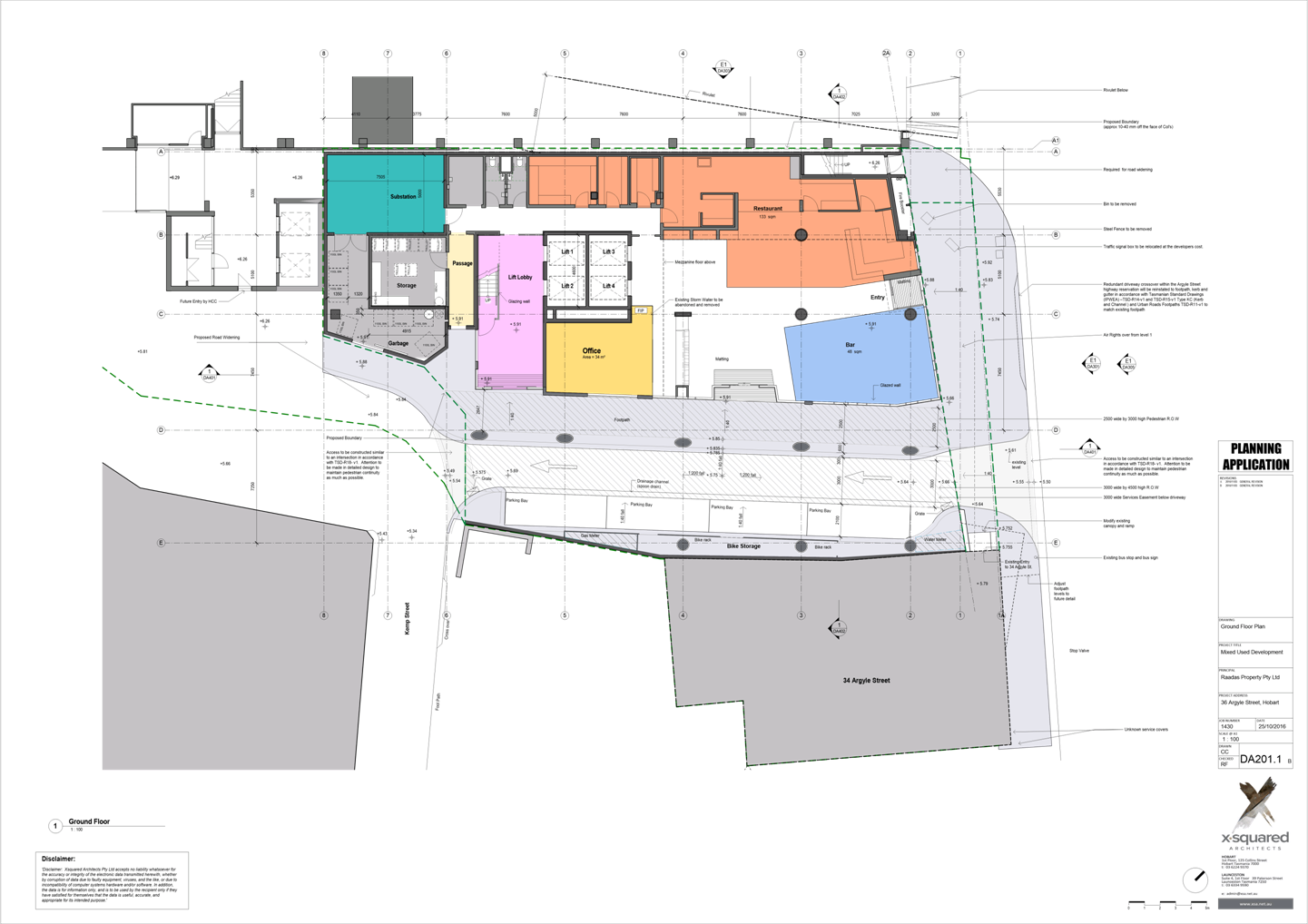
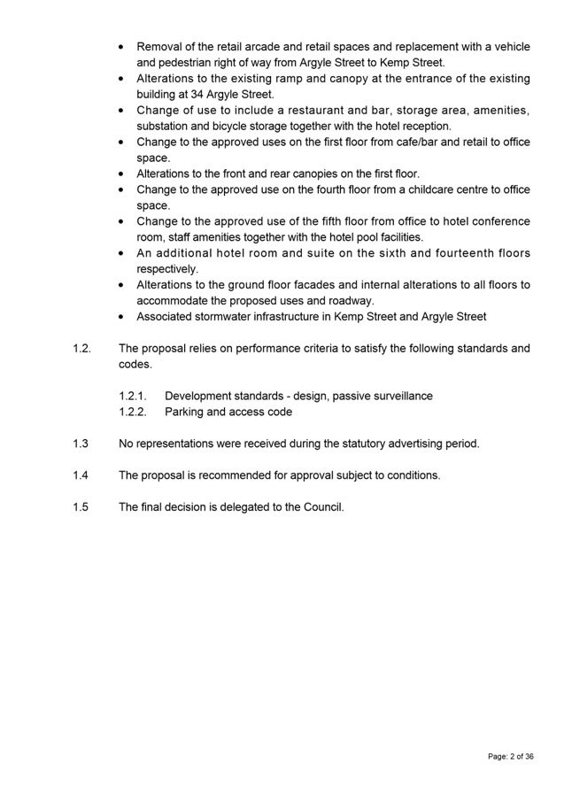
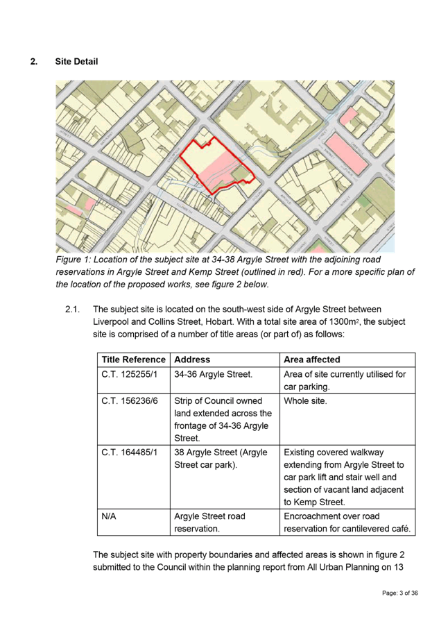
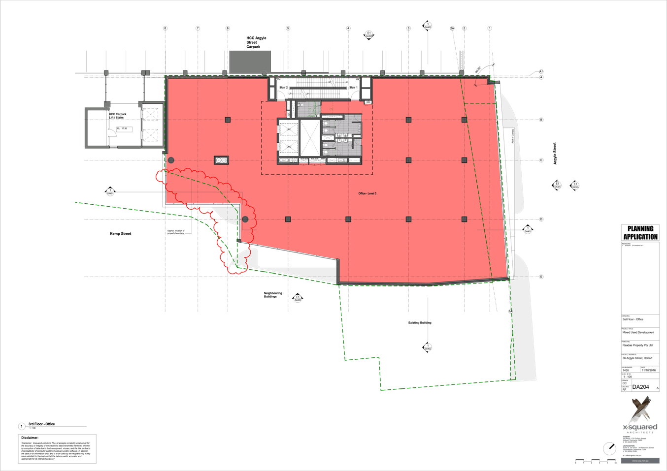
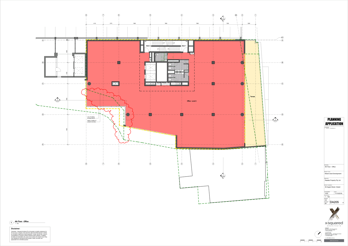
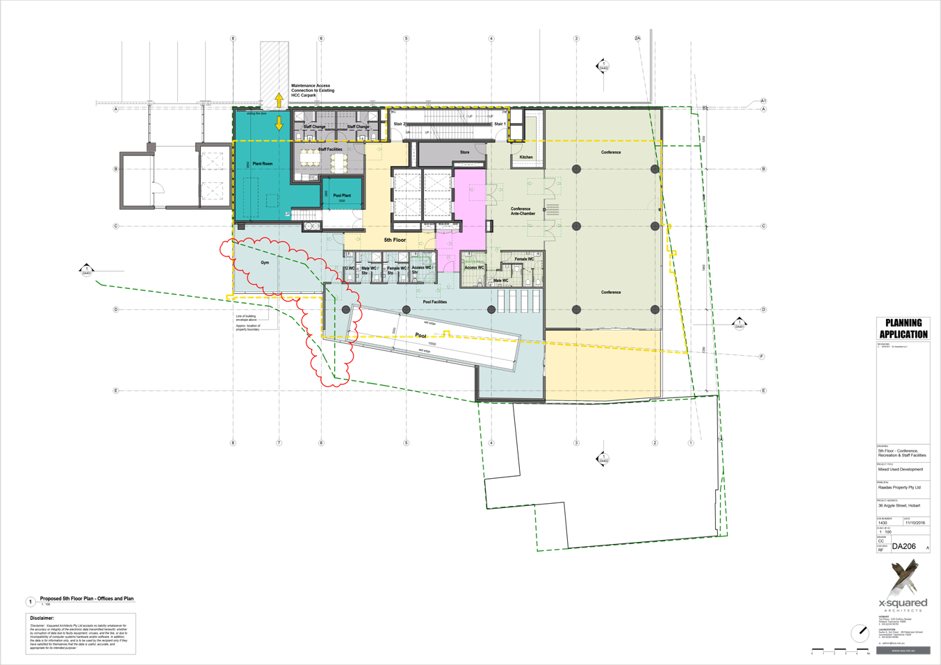
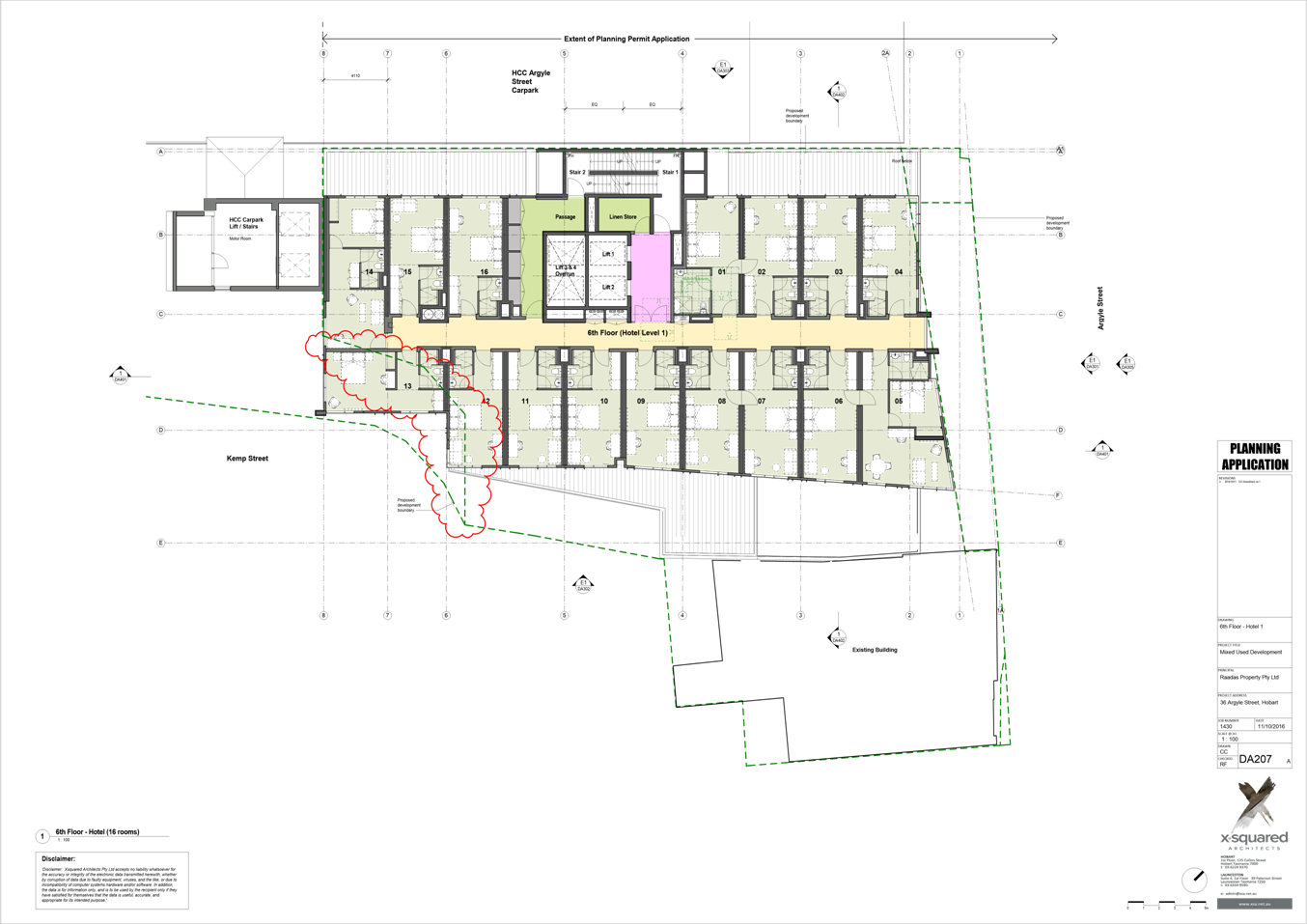
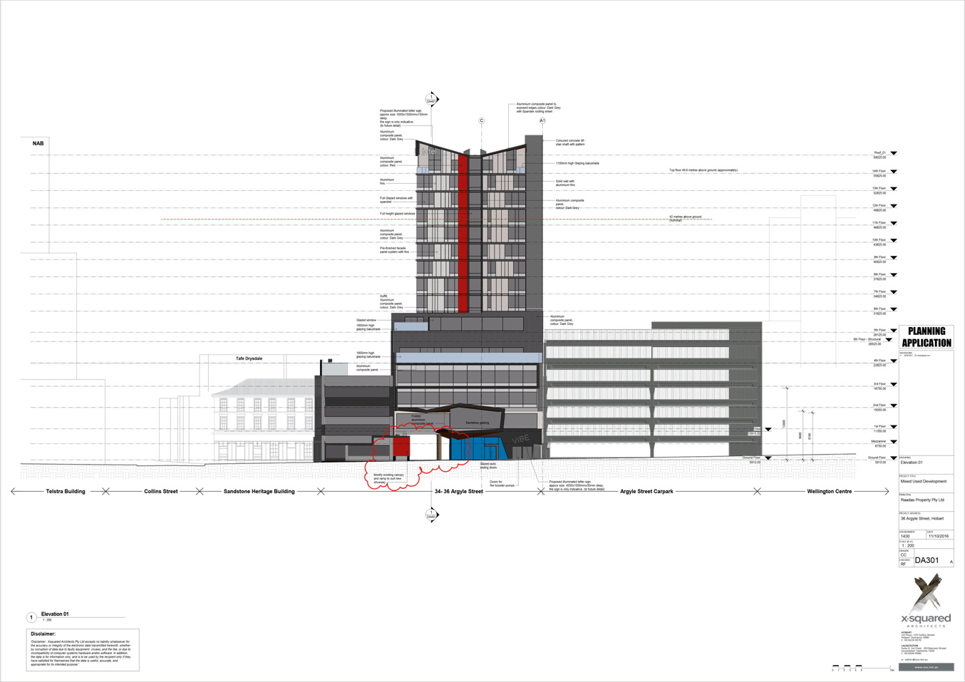
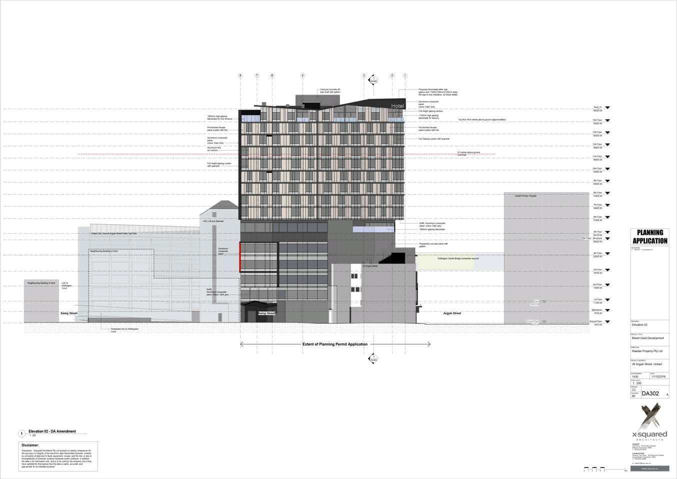
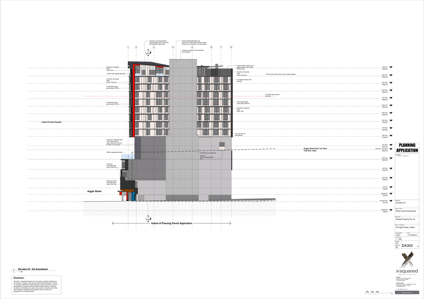
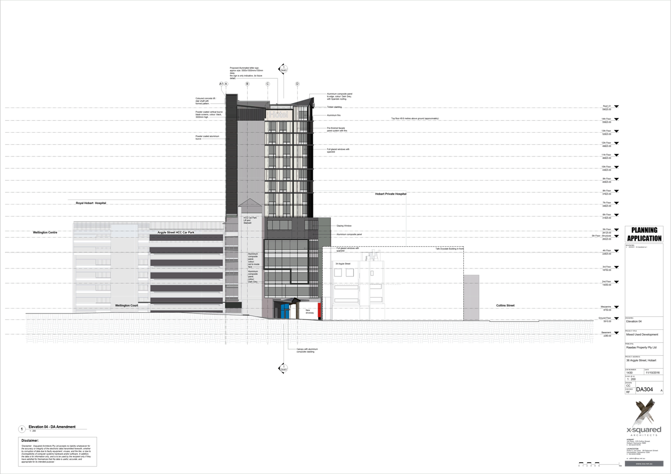
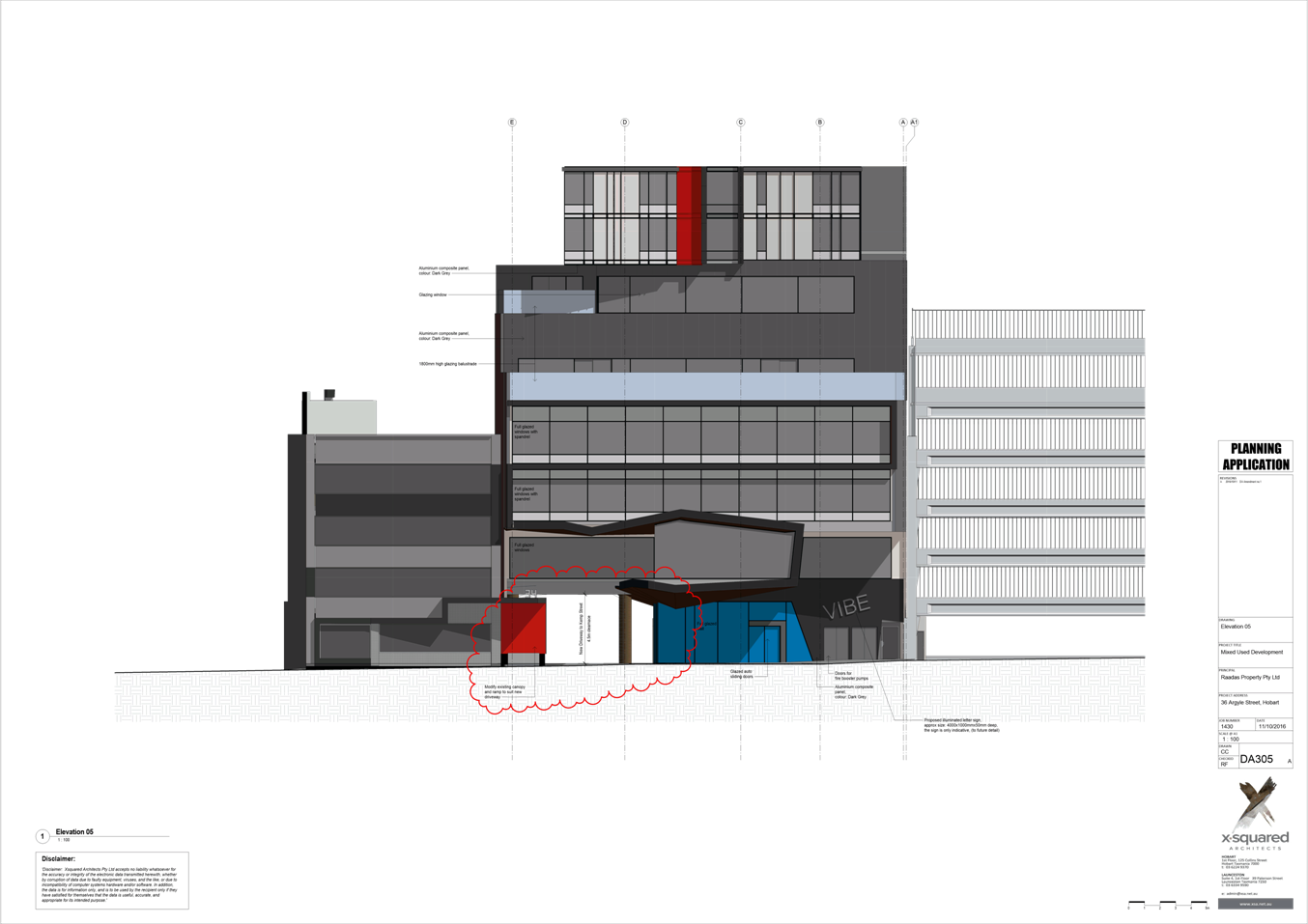
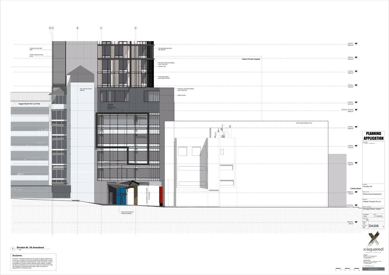
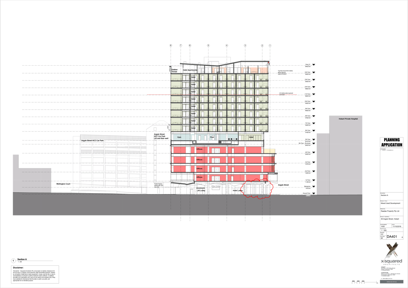
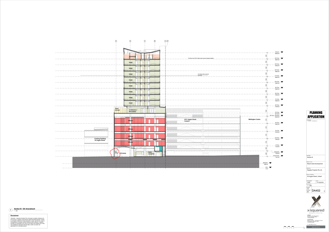
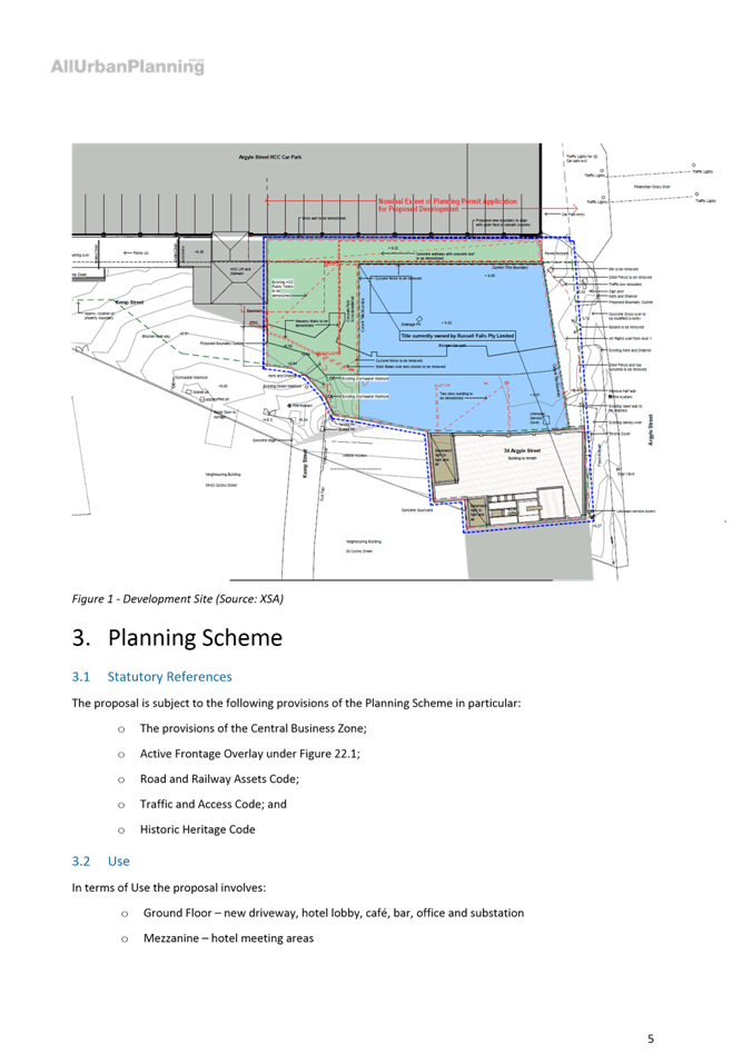
7.1.1 34 Argyle Street, 38 Argyle Street and Adjacent Road Reserve, Hobart - Alterations to previously approved development (PLN-14-00952-01) signage and partial change of use to visitor accommodation (including restaurant, bar and conference facilities) and offices
PLN-16-1069
FILE REF: F16/135569
Address: 34 Argyle Street, 38 Argyle Street and Adjacent Road Reserve, Hobart
Proposal: Alterations to previously approved development (PLN-14-00952-01), signage and partial change of use to visitor accommodation (including restaurant, bar and conference facilities) and offices
Expiry Date: 20 December 2016
Extension of Time: Not applicable
Author: Michaela Nolan
|
REcommendation That pursuant to the Hobart Interim Planning Scheme 2015, the Council approve the application for Alterations to Previously Approved Development (PLN140095201), Signage and Partial Change of Use to Visitor Accommodation (Including Restaurant, Bar and Conference Facilities) and Offices at 34 and 38 Argyle Street and adjacent road reserve, Hobart for the reasons outlined in the officer’s report and a permit containing the following conditions be issued:
GEN
The use and/or development must be substantially in accordance with the documents and drawings that comprise PLN161069 34 ARGYLE STREET & 38 ARGYLE STREET & ADJACENT ROAD RESERVE HOBART TAS 7000 Final planning documents, except where modified below.
Reason for condition
To clarify the scope of the permit.
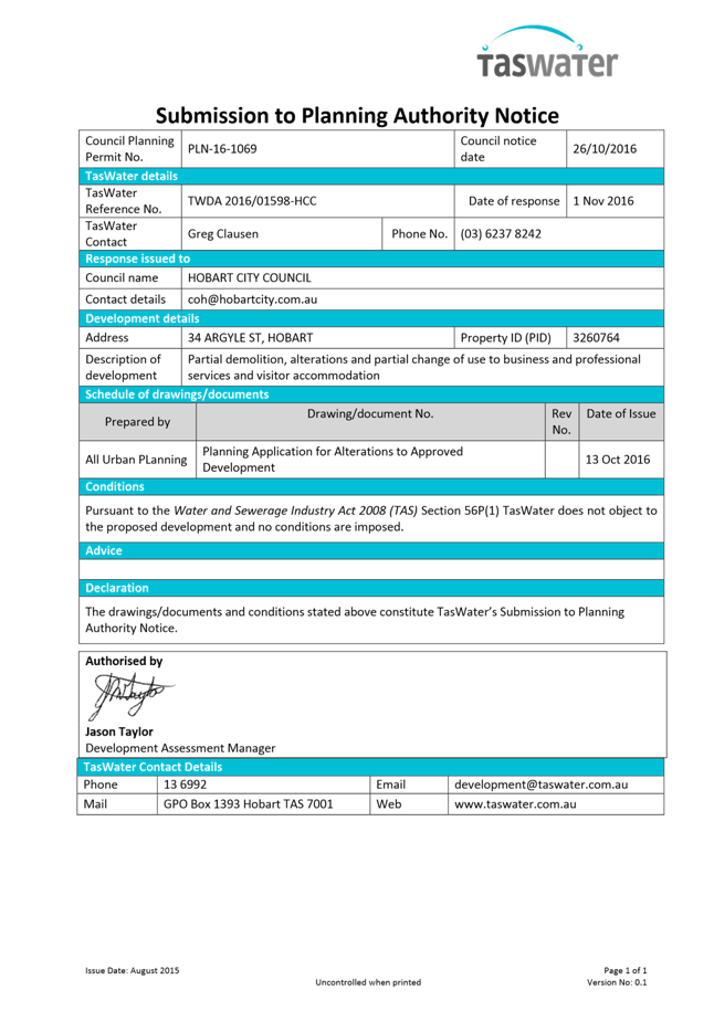
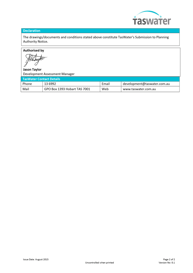
TW
The use and/or development must comply with the requirements of TasWater as detailed in the form Submission to Planning Authority Notice, Reference No. TWDA 2016/01598HCC dated 1 November 2016 as attached to the permit.
Reason for condition
To clarify the scope of the permit.
PLN s1
This permit is subject to and conditional on substantial commencement of the development approved by planning permit PLN140095201. This permit will lapse if planning permit PLN140095201 does not take effect.
Reason for condition
To clarify the scope of the permit.
PLN s2
No signage is approved by this permit. Any proposed signage requiring planning approval must be the subject of a separate planning application, submitted to and approved by the Hobart City Council.
Reason for condition
To clarify the scope of the permit.
ENG sw s1
Any existing stormwater mains to be made redundant as a result of the development must be formally abandoned as Council infrastructure at the developer’s cost, prior to the commencement of work.
An inpipe CCTV inspection of any of the Council’s infrastructure to be abandoned must be undertaken by a Councilapproved contractor at the developer’s cost, to locate and identify all connections.
Advice: Once the CCTV and associated report have been approved Council will issue a condition endorsement (see general advice on how to obtain condition endorsement).
Reason for condition
To ensure the protection of the Council’s hydraulic infrastructure.
ENG sw3
The proposed development must be designed to ensure the long term protection and access to the Council’s storm water infrastructure, including the protection of any infrastructure that is to be temporarily retained and abandoned later.
A detailed engineering design must be submitted and approved prior to commencement of works. The detailed design must:
1. Demonstrate, including sections, how the design will ensure the protection of and access to Council’s stormwater main(s). 2. Be certified by a suitably qualified and experienced engineer.
All work required by this condition must be undertaken in accordance with the approved design.
Advice: Once the detailed design drawings has been approved the Council will issue a condition endorsement (see general advice on how to obtain condition endorsement).
Reason for condition
To ensure the protection of the Council’s hydraulic infrastructure.
ENG sw s2
Safe and efficient drainage of the site and surrounds must be maintained throughout the construction of the development.
A Construction Sequence Plan (CSP) must be submitted and approved prior to the commencement of work. The CSP must detail:
The construction sequence for the works, with any necessary contingency options, including but not limited to: 1. The existing and future surface levels in Kemp Street. 2. The abandonment of any existing public infrastructure, or temporary retention (and protection) of any existing public infrastructure. 3. Reconnection of any private services effected by the development.
All work required by this condition must be undertaken in accordance with the approved CSP.
Advice: Once the CSP has been approved Council will issue a condition endorsement (see general advice on how to obtain condition endorsement).
Reason for condition
To ensure that the site and surrounding land is adequately drained.
ENG sw5
The proposed alterations to the public stormwater infrastructure must be designed and constructed prior to the commencement of use.
Engineering drawings must be submitted and approved (along with supporting calculations and catchment analysis), prior to commencement of work. The engineering drawings must:
1. Be certified by a qualified and experienced engineer. 2. Include both plan, long and cross sections of the proposed mains, including the finished surface levels for the right of way, the road reserve in both Kemp and Argyle Street, and hotel floor levels. 3. Include any existing stormwater mains to be abandoned. 4. Include all other services and potential clashes. 5. Include detailed design of the connection into the Hobart Rivulet (including minimisation of hydraulic intrusion and scour protection). 6. Include details of sizing, cover, grade, pipe material and class, connections, velocities, clearances to structures and services, easements. 7. Demonstrate how the system will accommodate flows associated with a 1% AEP rainfall event at 2100 (i.e. including a loading for climate change). The system incorporates both the piped system and designated overland flow paths. 8. Demonstrate that the proposed alterations to the stormwater infrastructure do not adversely impact any third party properties. 9. Include consideration of the flood levels in the Hobart Rivulet and their impact on receiving drainage capacity.
All work required by this condition must be undertaken in accordance with the approved engineering drawings.
Advice: Once the engineered drawings has been approved Council will issue a condition endorsement (see general advice on how to obtain condition endorsement).
Any construction of public infrastructure (which will be taken over by the Council) must be carried out either by the Council or by a Councilapproved private contractor with a Permit to Construct Public Infrastructure. A maintenance period of 12 months will apply, and a Maintenance Bond equal to 5% of the contract value of the works must be lodged with the Council in the form of a cash deposit or bank guarantee from an approved financial institution. This bond will be released at the end of the 12 months maintenance period should no maintenance works on public infrastructure be required. This will be demonstrated by a final inspection by the Council, and submission of a recorded CCTV inspection and associated report of all new public stormwater infrastructure taken no more than one month before the end of the maintenance period. Where remedial works are to be undertaken, the bond will not be released until the works are completed to the satisfaction of the Council’s Director Infrastructure Services.
Reason for condition
To ensure Council’s hydraulic infrastructure meets acceptable standards.
ENG sw6
All stormwater from the proposed development (including roofed areas and runoff from the right of way) must be discharged via gravity to the Council’s infrastructure prior to first occupation. All costs associated with works required by this condition are to be met by the owner.
Design drawings (including supporting calculations) of the proposed stormwater drainage and connection(s) to Council infrastructure must be submitted and approved prior to the commencement of work. The design drawings must:
1. Be prepared by a suitably qualified person. 2. Provide a single connection to Council infrastructure for each final lot, separate to each lot, sized to meet the needs of the development. 3. Clearly distinguish between public and private infrastructure. 4. Identify any existing connections to be made redundant. 5. Incorporate consideration of the limited receiving capacity of the downstream system. 6. Include long section(s), levels, and grades to the point of discharge.
All work required by this condition must be undertaken in accordance with the approved design drawings.
Advice: Once the design drawing has been approved Council will issue a condition endorsement (see general advice on how to obtain condition endorsement).
Reason for condition
To ensure that stormwater from the site will be discharged to a suitable Council approved outlet.
ENG sw s3
The proposed development and new public infrastructure works must not adversely impact the Hobart Rivulet.
A Construction Management Plan (CMP) must be submitted and approved prior to commencement of works. The CMP must:
· Detail the methodology for installing the connection into the Hobart Rivulet
· Detail how the Rivulet will be protected, with consideration of (but not limited to): 1. Likely forces associated with the construction, including vibration, traffic loading, etc. 2. Extent and duration of excavation next to the rivulet 3. Risk treatment plan for all reasonably possible risks, e.g flood, collapse of Rivulet wall, undermining, environmental damage to the waterway, project delays, unknown Rivulet construction or condition, etc. 4. Be prepared by a suitably qualified and experienced person.
All work required by this condition must be undertaken in accordance with the approved CMP.
Advice: Once the CMP has been approved the Council will issue a condition endorsement (see general advice on how to obtain condition endorsement).
Reason for condition
To ensure the protection of the Council’s hydraulic infrastructure.
ENG tr2
A construction traffic and parking management plan must be implemented prior to the commencement of work on the site (including demolition).
The construction traffic (including cars, public transport vehicles, service vehicles, pedestrians and cyclists) and parking management plan must be submitted and approved, prior to commencement work. The construction traffic and parking management plan must:
1. Be prepared by a suitably qualified person, by the Council; 2. Develop a communications plan to advise the wider community of the traffic and parking impacts during construction; 3. Include a start date and finish dates of various stages of works; 4. Include times that trucks and other traffic associated with the works will be allowed to operate; and 5. Nominate a superintendant or like to advise the Council of the progress of works in relation to the traffic and parking management with regular meetings during the works.
All work required by this condition must be undertaken in accordance with the approved construction traffic and parking management plan.
Advice: Once the construction traffic and parking management plan has been approved Council will issue a condition endorsement (see general advice on how to obtain condition endorsement).
Reason for condition
To ensure the safety of vehicles entering and leaving the development and the safety and access around the development site for the general public and adjacent businesses.
ENG 1
The cost of repair of any damage to the Council infrastructure resulting from the implementation of this permit, must be met by the owners within 30 days of the completion of the development or as otherwise determined by the Council.
A photographic record of the Council infrastructure adjacent to the subject site must be provided to the Council prior to any commencement of works.
A photographic record of the Council’s infrastructure (e.g. existing property service connection points, roads, buildings, stormwater, footpaths, driveway crossovers and nature strips, including if any, pre existing damage) will be relied upon to establish the extent of damage caused to the Council’s infrastructure during construction. In the event that the owner/developer fails to provide to the Council a photographic record of the Council’s infrastructure, then any damage to the Council infrastructure found on completion of works will be deemed to be the responsibility of the owner.
Reason for condition
To ensure that any of the Council infrastructure and/or siterelated service connections affected by the proposal will be altered and/or reinstated at the owner’s full cost.
ENGR 3
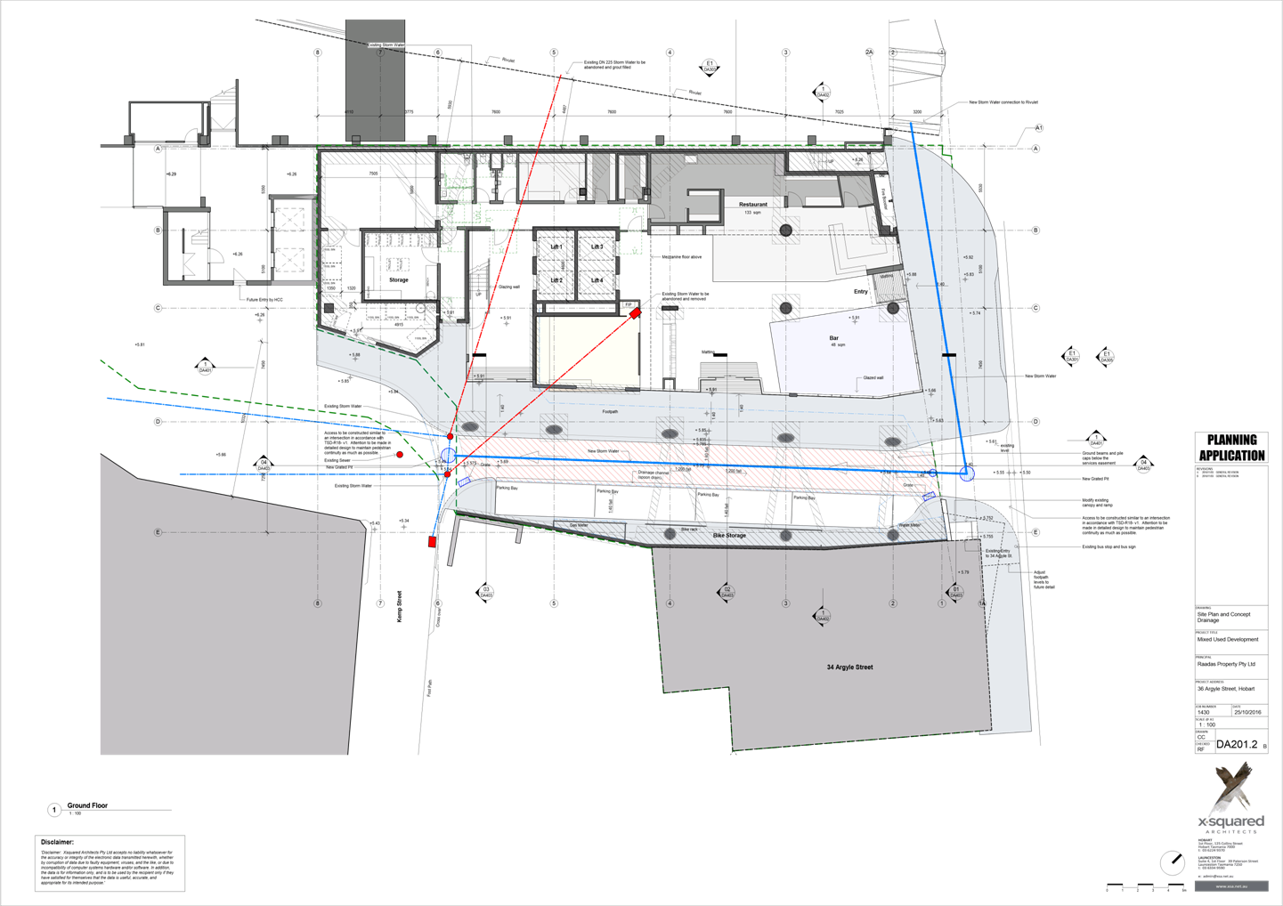
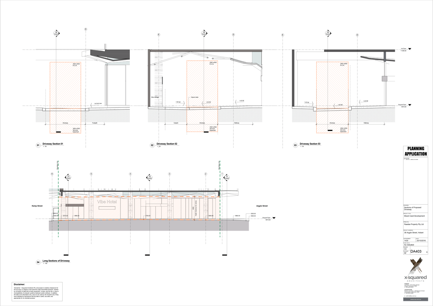
The proposed driveway access within the Argyle Street and Kemp Street highway reservation must be designed and constructed in accordance with the drawings submitted and the Tasmanian Standard Drawings and other relevant standards, guidelines and codes prior to the commencement of the use.
Design
drawing must be submitted and
approved prior to the commencement of work. The design
drawing must: · Show cross and long section of the driveway access within the highway reservation, into the property and along the footpath. · Detail the standard the access, including road pavement, kerbs and footpath will be design and constructed too. · Detail the location and level of any services or infrastructure at or near the proposed driveway access. · The access to be designed for heavy vehicle loadings.
· Show swept path templates in accordance with AS/NZS 2890.1 2004 (B85 or B99 depending on use). · All works should be in accordance with the Tasmanian Standard Drawings. · Be prepared and certified by a suitable qualified person, to satisfy the above requirement.
All work required by this condition must be undertaken in accordance with the approved drawings.
Advice: Once the approved drawings has been approved Council will issue a condition endorsement (see general advice on how to obtain condition endorsement).
Reason for condition
To ensure that works will comply with the Council’s standard requirements.
ENGR s1
The pavers within the Argyle Street, Collins Street and Kemp Street highway reservation that will be effected by the construction must be removed and replaced with a temporary asphalt seal at the developers cost prior to the commencement of work. The pavers must not be damaged during the process and stored off site. The pavers are to be reinstated at end of the development at the developers cost and to the satisfaction of the Director City Infrastructure.
Reason for condition
To ensure that works will comply with the Council’s standard requirements.
ENGR s2
Provide details on the widening of the footpath on Argyle Street, the reinstatement of existing footpath on Argyle Street and new footpath within Kemp Street, prior to the commencement of work.
Detail engineering drawings must be submitted and approved, prior to commencement of work. The drawings must:
· Show the location of new and existing footpaths within the highway reservation. · Show cross and long section of the new and existing footpaths within the highway reservation Note: that the agreement of the Council’s is required to adjust footpath levels. · Detail the standard the footpaths and associated infrastructure such as ramps and kerbs will be design and constructed to. · Detail the location and level of any services or infrastructure at or near the proposed and existing footpaths. · All works should be in accordance with the Tasmanian Standard Drawings and other relevant standards, guidelines and codes. · Be prepared and certified by a suitable qualified person, to satisfy the above requirement.
All work required by this condition must be undertaken in accordance with the approved drawings.
Advice: Once the drawings have been approved Council will issue a condition endorsement (see general advice on how to obtain condition endorsement)
Reason for condition
To ensure that works will comply with the Council’s standard requirements.
ENGR s3
The traffic signal box and street bin on Argyle Street are to be relocated to the back of the footpath along the building line or removed/placed underground at the developers cost, prior to first occupation.
Reason for condition
To ensure that works will comply with the Council’s standard requirements.
ENGR s4
A street lighting design for roads, footways and driveway access which the City has an interest in, surrounding the development site must be submitted and approved prior to the commencement of work. The street lighting design must be:
· in accordance with AS/NZS 1158 series to the requirements of Tas Network and Council.
· include Tas Networks standard supplied poles and energyefficient road light fittings if lighting in the highway reservation be certified by a qualified person.
All work required by this condition must be undertaken in accordance with the approved street lighting design. The ongoing maintenance of the lighting of the driveway access will be at the owners cost.
Advice: Once the street lighting design has been approved the Council will issue a condition endorsement (see general advice on how to obtain condition endorsement.)
Reason for condition
To ensure that works will comply with the Council’s standard requirements.
ENV 2
Sediment and erosion control measures, in accordance with an approved soil and water management plan (SWMP), must be installed prior to the commencement of work and maintained until such time as all disturbed areas have been stabilised and/or restored or sealed to the Council’s satisfaction.
A SWMP must be submitted and approved, prior to the commencement of work. The SWMP must:
a. be prepared in accordance with
the Soil and
Water Management on
Building and Construction Sites
fact sheets (Derwent Estuary Program, 2008). http://www.hobartcity.com.au/Development/Engineering_Standards_and_Gui
deline.
Advice: Once the SWMP has been approved the Council will issue a condition endorsement (see general advice on how to obtain condition endorsement).
Reason for condition
To avoid the pollution and sedimentation of roads, drains and natural watercourses that could be caused by erosion and runoff from the development.
SURV 8
The applicant, at no cost to the Council shall have prepared, entered into, and have registered at the Land Titles Office, a deed pursuant to Section 75CA of the Conveyancing and Law of Property Act 1884 for any building encroachments over the Argyle and Kemp Street highway, prior to the issue of a certificate of occupancy.
Advice: A Section 75CA Conveyancing & Law of Property Act 1884 certificate for the occupation of a Highway requires that the encroachment is a minimum 2.40 metres above the footpath or 4.25 metres above the road carriageway. A 600mm set back from the back of kerb may also be required.
The applicant must prepare and forward the required instrument pursuant to section 75CA Conveyancing & Law of Property Act 1884, including a survey plan of the encroachment (certified by a registered surveyor), the associated $220 Council application fee and the Land Titles Office registration fee, to the Council for execution and subsequent registration within the Land Titles Office.
Reason for condition
To ensure that the proposed building encroachments over Argyle and Kemp Streets are formalised in accordance with statutory provisions.
SUB s1
A Right of Way, service easement and floodway easement in favour of the Hobart City Council over the driveway and footpath from Argyle through to Kemp Street must be provided to the satisfaction of the Council’s Director City Infrastructure and Director City Planning prior to the issue of any certificate of occupancy for the development. The Right of Way, service easement and floodway easement are to be created by Transfer of Easements under section 58 of the Land Titles Act 1980. All costs associated with the creation of these easements are to be paid by the applicant.
Reason for condition
To ensure that there is no impediment to public access from Argyle Street to Kemp Street, to enable maintenance of Council’s infrastructure and ensure that overland flow path through the site remains unobstructed at all times.
SUB s2
Road widening must be provided along Kemp and Argyle Streets within land currently comprised in certificates of title 164485/1 and 164485/0 as shown on the Hobart City Council’s plan S19441 Revision A dated 23/11/2016 or otherwise determined. The extent of the road widening must be to the satisfaction of the Council’s Director City Infrastructure. The road widening must be dedicated as road on the final plan of survey associated with PLN140095201 and transferred to the Hobart City Council. Please refer to the Final Plan of Survey advice clause.
Reason for condition
To ensure that the title to the road lots issue in the Hobart City Council.
SUB s3
An amendment to strata plan 164485 must be submitted concurrently with the final plan of survey associated with PLN140095201 for the boundary adjustment and approved by the Council in accordance with the requirements of Sections 19 and 31 of the Strata Titles Act 1998 prior to the sealing of the final plan for the boundary adjustment associated with PLN140095201. The amendment to strata plan 164485 is to reflect the proposed boundary adjustment and the road widening required along Kemp and Argyle Streets.
Reason for condition
To ensure compliance with statutory provisions.
ADVICE
The following advice is provided to you to assist in the implementation of the planning permit that has been issued subject to the conditions above. The advice is not exhaustive and you must inform yourself of any other legislation, bylaws, regulations, codes or standards that will apply to your development under which you may need to obtain an approval. Visit www.hobartcity.com.au for further information.
Prior to any commencement of work on the site or commencement of use the following additional permits/approval may be required from the Hobart City Council.
CONDITION ENDORSEMENT
If a condition endorsement is required by a planning condition above, you will need to submit the relevant documentation to satisfy the condition, via the Condition Endorsement Submission on Council's online eservice portal.
Once approved, the Council will respond to you via email that the condition(s) has been endorsed (satisfied). Detailed instructions can be found at http://www.hobartcity.com.au/Development/Planning/How_to_obtain_a_condition_e ndorsement
BUILDING PERMIT
Building permit
in accordance with the Building Act 2000;
http://www.hobartcity.com.au/Development/Building
Plumbing permit
under the Tasmanian Plumbing Regulations 2014;
http://www.hobartcity.com.au/Development/Plumbing
Permit for the occupation of the public highway for construction or special event (e.g. placement of skip bin, crane, scissor lift etc).
http://www.hobartcity.com.au/Transport/Permits/Construction_Activities_Special_Even ts_in_the_Road_Reservation
Permit to Open Up and Temporarily Occupy a Highway (for work in the road reserve).
WORK WITHIN THE HIGHWAY RESERVATION
Please note development must be in accordance with the Hobart City Council’s Highways By law http://www.hobartcity.com.au/Council/Legislation
DRIVEWAY SURFACING OVER HIGHWAY RESERVATION
If a coloured or textured surface is used for the driveway access within the Highway Reservation, the Council or other service provider will not match this on any reinstatement of the driveway access within the Highway Reservation required in the future.
FINAL PLAN OF SURVEY
The applicant will need to prepare and arrange for the execution of a Land Titles Office transfer and partial discharge of mortgage (if required) for the road lots, attend to the assessment and payment of Stamp Duty with the Commissioner of Taxes and forward the stamped instruments together with the associated Land Titles Office registration fees (cheque made payable to the Recorder of Titles for $200.43 (transfer) and $162.18 (partial discharge of mortgage) and a completed notice of sale, to the Council’s Manager Surveying Services prior to the sealing of the final plan of survey.
HERITAGE
Should any brick or sandstone material be excavated during the installation of the stormwater pipe into the Hobart Rivulet, work is to cease and Council's Cultural Heritage Officer is to be notified. Please contact Sarah Waight on 6238 2175.
CONSISTENCY WITH PLANNING APPROVAL PLN140095201
The applicant is encouraged to contact the Council to discuss amending the original approval for the site to remove any conditions on the 2014 permit that are superseded by or in conflict with the conditions imposed by this permit. Please contact the Council's Senior Statutory Planner in the first instance on 6238 2715 to initiate this discussion.
|
Attachment a: PLN-16-1069
- 38 ARGYLE STREET HOBART TAS 7000 - Planning Committee or Delegated Report ⇩ ![]()
Attachment
b: PLN-16-1069
- 34 ARGYLE STREET & 38 ARGYLE STREET & ADJACENT ROAD RESERVE HOBART
TAS 7000 - CPC Agenda Documents ⇩ ![]()
Attachment
c: PLN-16-1069
- 34 ARGYLE STREET & 38 ARGYLE STREET & ADJACENT ROAD RESERVE - HOBART
TAS 7000 - CPC Supporting Documents (Supporting information) ⇨ ![]()
|
Item No. 7.1.1 |
Agenda (Open Portion) City Planning Committee Meeting - 12/12/2016 |
Page 24 ATTACHMENT a |

|
Agenda (Open Portion) City Planning Committee Meeting - 12/12/2016 |
Page 60 ATTACHMENT b |

|
Item No. 7.1.1 |
Agenda (Open Portion) City Planning Committee Meeting - 12/12/2016 |
Page 104 ATTACHMENT b |


|
Item No. 7.1.1 |
Agenda (Open Portion) City Planning Committee Meeting - 12/12/2016 |
Page 127 ATTACHMENT b |
|
Item No. 7.1.1 |
Agenda (Open Portion) City Planning Committee Meeting - 12/12/2016 |
Page 133 ATTACHMENT b |
|
Item No. 7.1.2 |
Agenda (Open Portion) City Planning Committee Meeting |
Page 134 |
|
|
12/12/2016 |
|
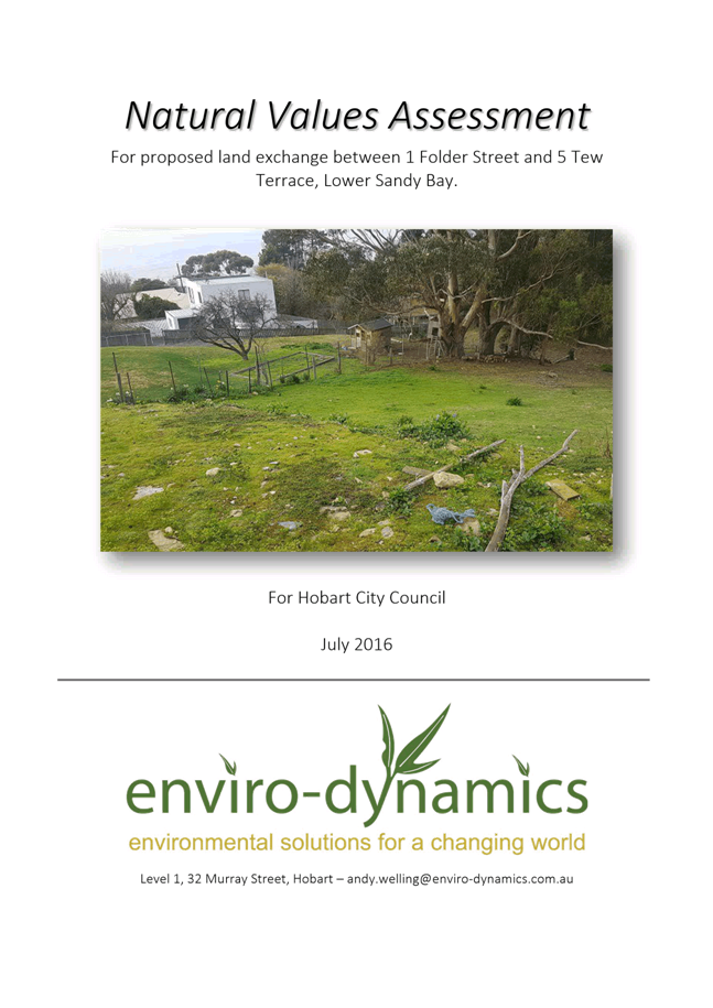
7.1.2 Hobart Interim Planning Scheme 2015 - Planning Scheme Amendment 8/2016 and S43A Permit Application - 1 Folder Street and 5 Tew Terrace Rezoning and Boundary Adjustment
File Ref: F16/99289
Report of the Manager Planning Policy and Heritage of 7 December 2016 and attachments.
Delegation: Council
|
Item No. 7.1.2 |
Agenda (Open Portion) City Planning Committee Meeting |
Page 135 |
|
|
12/12/2016 |
|
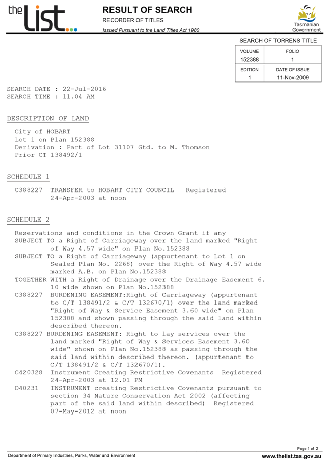
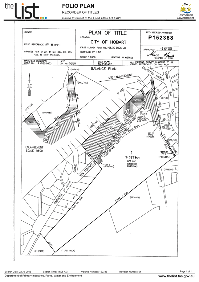
REPORT TITLE: Hobart Interim Planning Scheme 2015 - Planning Scheme Amendment 8/2016 and S43A Permit Application - 1 Folder Street and 5 Tew Terrace Rezoning and Boundary Adjustment
REPORT PROVIDED BY: Manager Planning Policy and Heritage
1. Report Purpose and Community Benefit
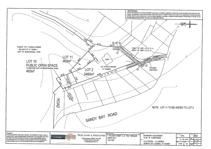
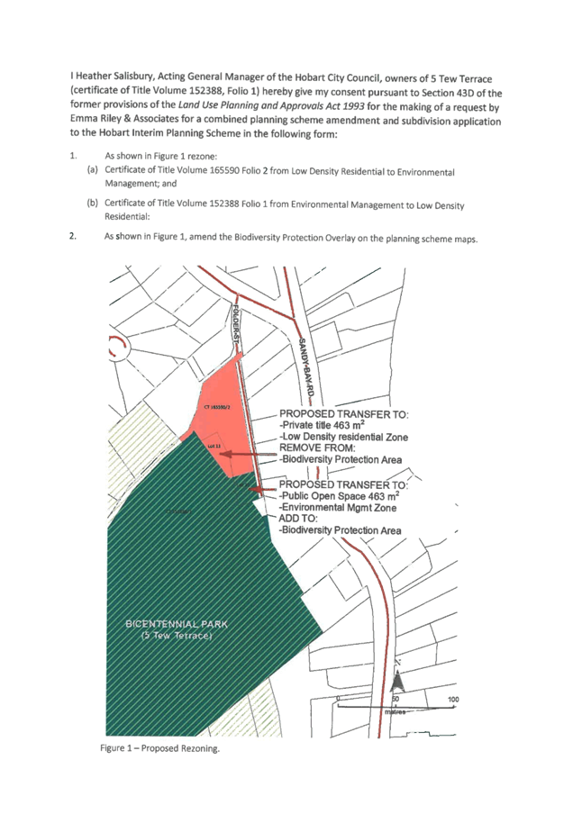
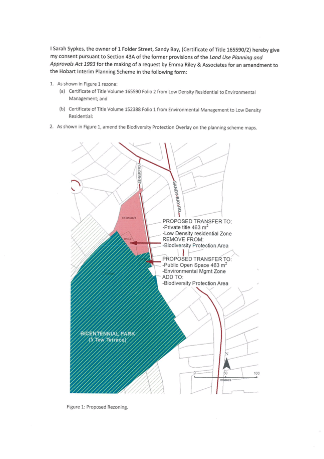
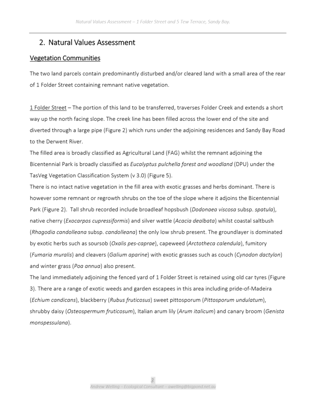
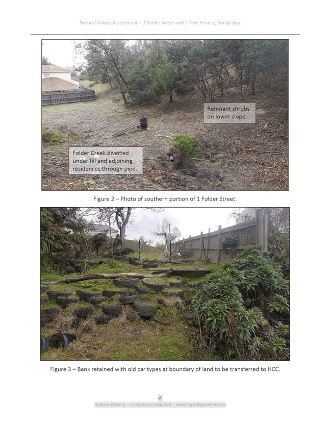
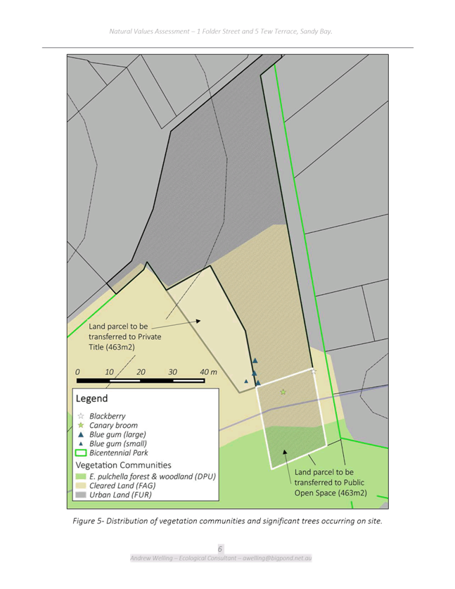
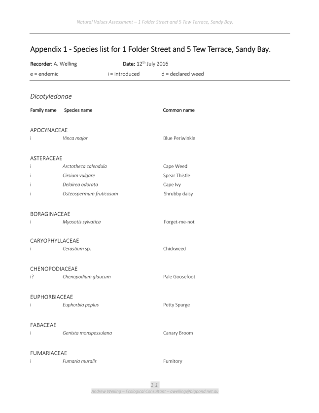
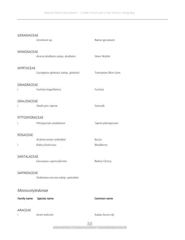
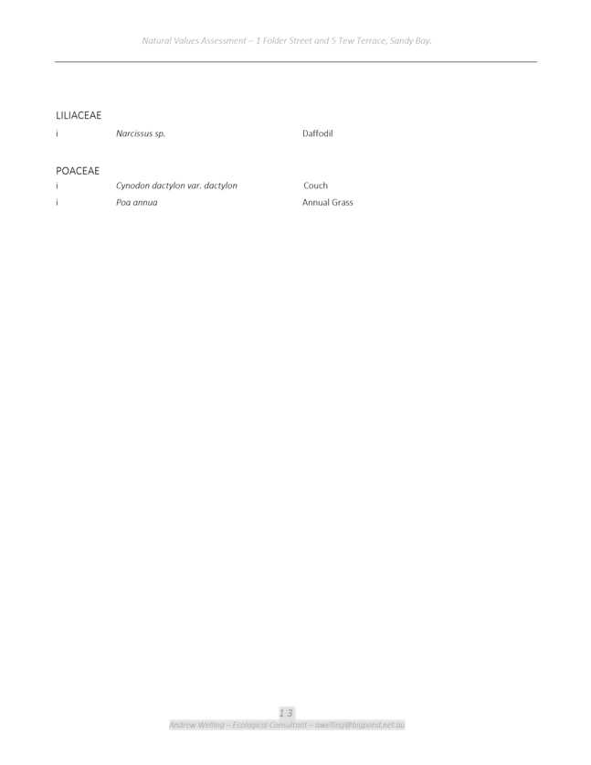
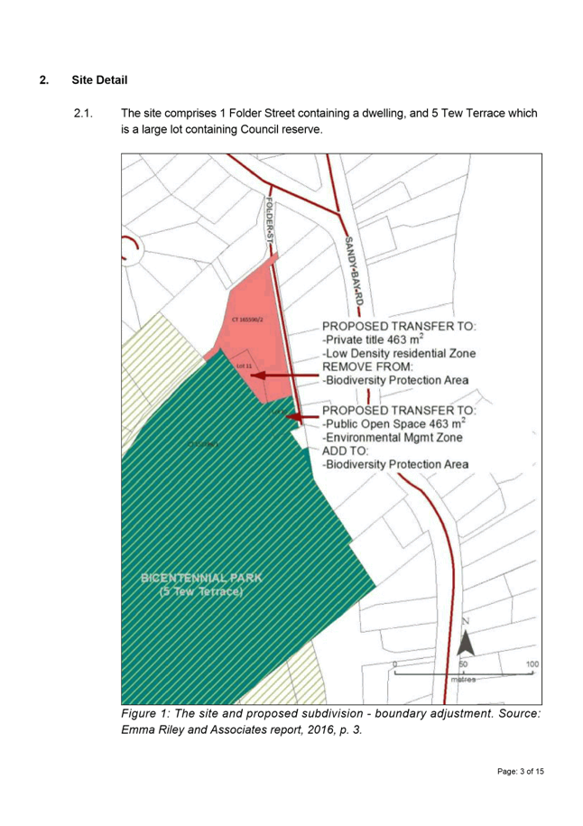
1.1. The purpose of this report is to consider an application under the Land Use Planning and Approvals Act 1993 (LUPAA), from Emma Riley and Associates on behalf of landowners Sarah Sypkes and City of Hobart, to amend the Hobart Interim Planning Scheme 2015 (HIPS 2015) by rezoning a portion of 1 Folder Street from Low Density Residential to Environmental Management, and a same sized portion of 5 Tew Terrace from Environmental Management to Low Density Residential. It is also proposed to amend the boundary of the Biodiversity Protection Area Overlay, and amend the heritage listing of 1 Folder Street under the Historic Heritage Code.
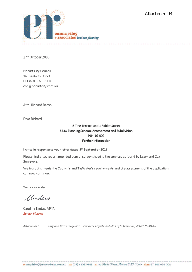
1.2. Pursuant to S43A of the former provisions of LUPAA, the planning scheme amendment application is combined with a planning permit application for Subdivision (Boundary Adjustment). The applicant’s submission in support of the rezoning is provided in Attachment A and documentation relating to the subdivision is provided in the attachments to the Development Appraisal Planner’s report in Attachment B.
1.3. The proposal benefits the community by ensuring that land is appropriately zoned and that development is undertaken in a fair and orderly manner.
2. Report Summary
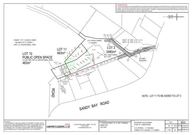
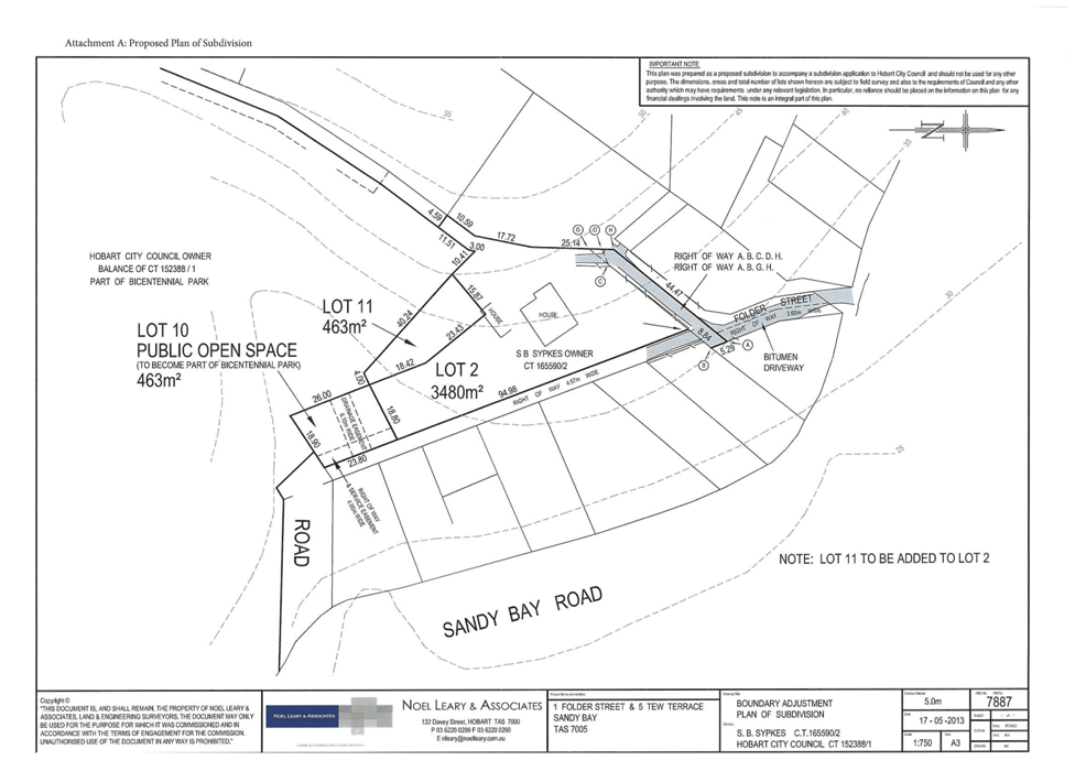
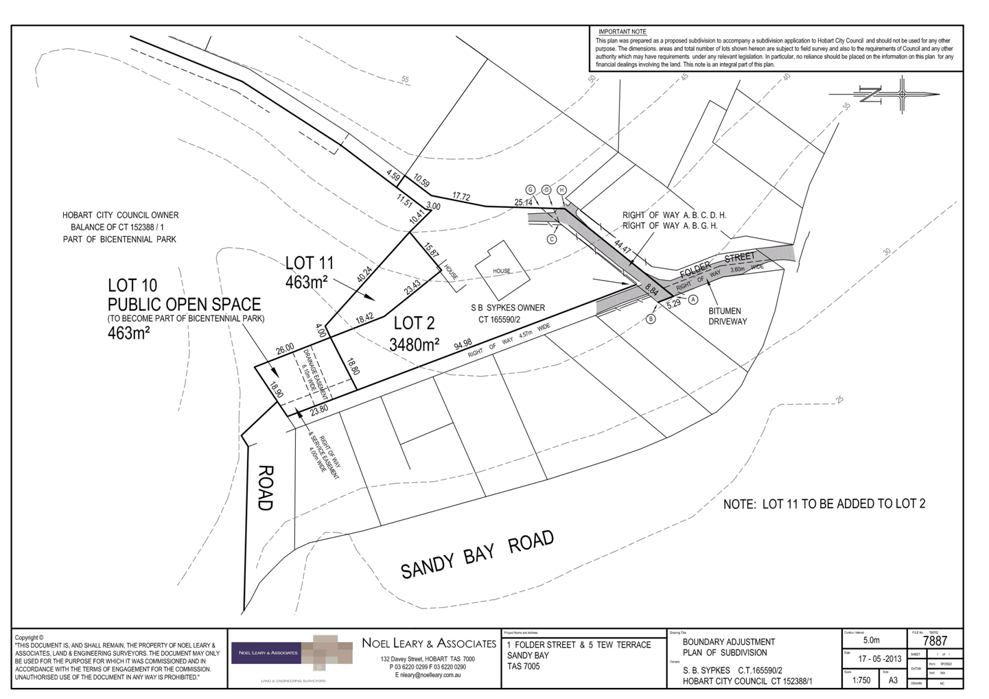
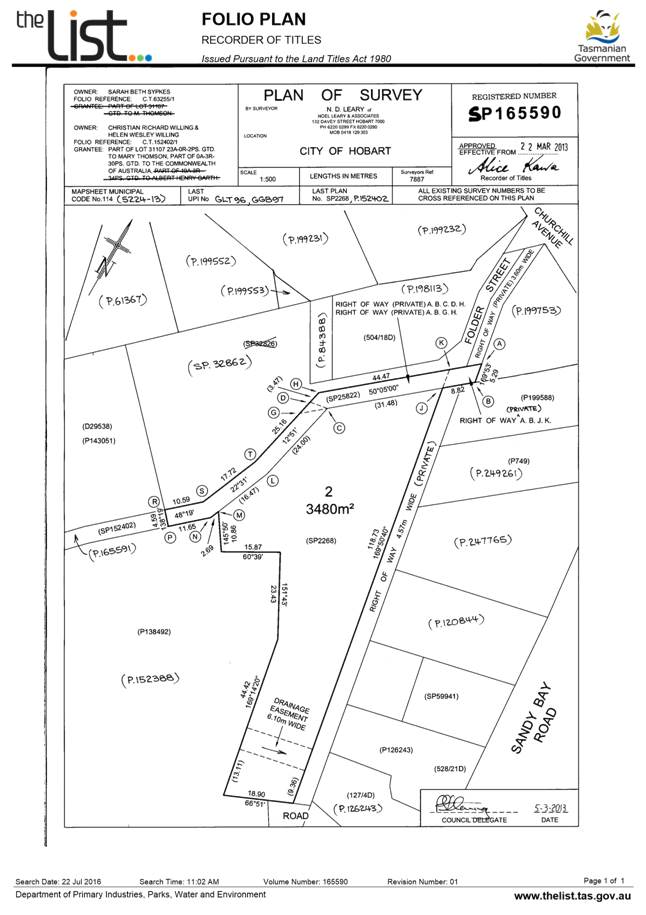
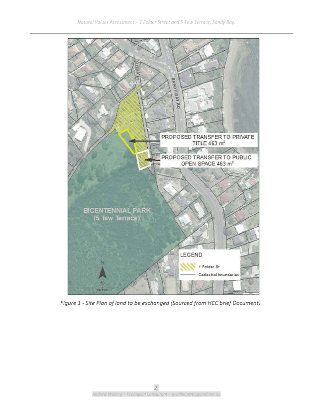
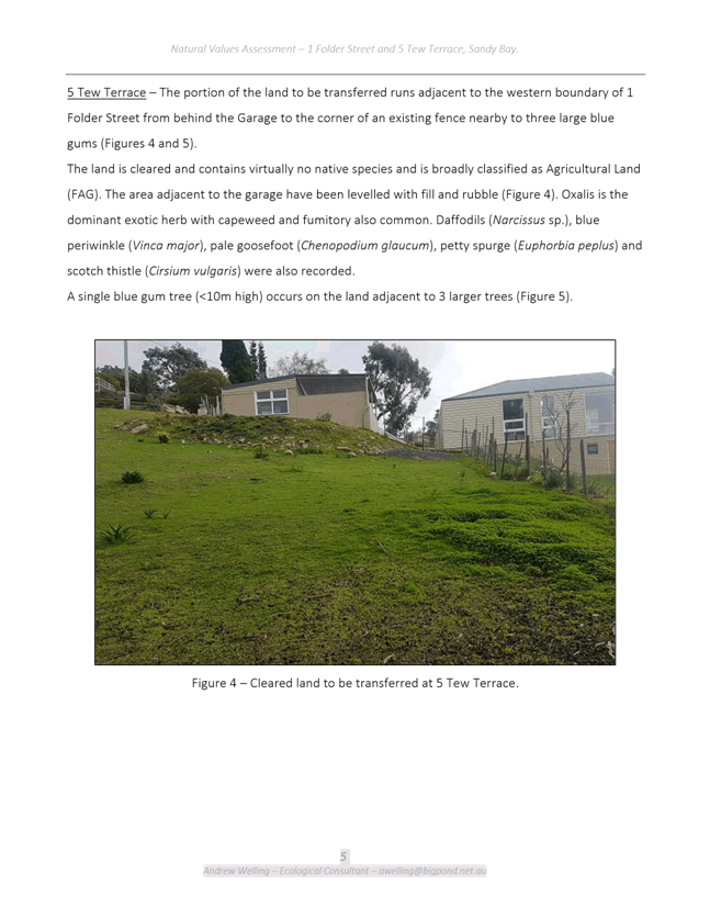
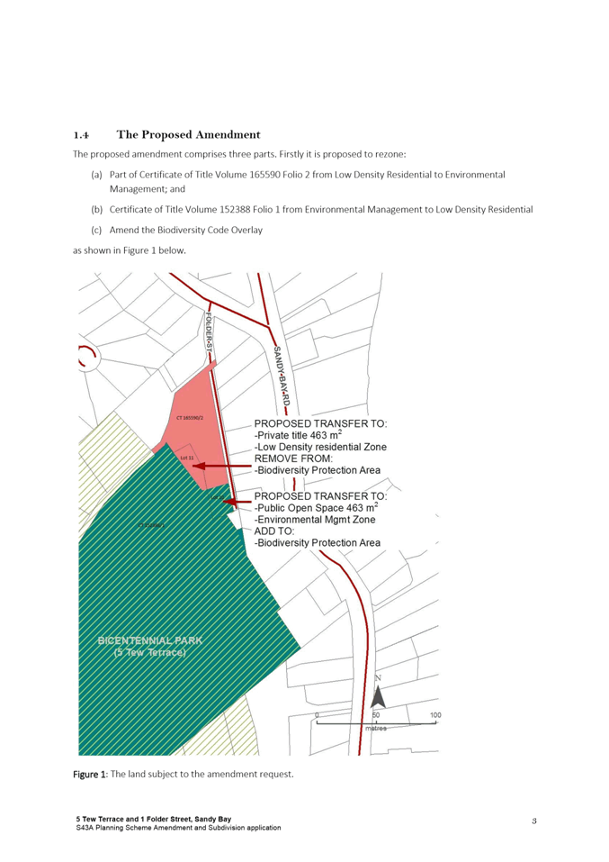
2.1. The proposal is to rezone a 463m2 portion of 1 Folder Street from Low Density Residential to Environmental Management and a 463m2 portion of 5 Tew Terrace from Environmental Management to Low Density Residential.
2.2. It is also proposed to remove the Biodiversity Protection Area Overlay from the area of land to be rezoned Low Density Residential, and to add the overlay to the area of land to be rezoned Environmental Management.
2.3. In addition, the heritage listing for 1 Folder Street will be amended to remove the reference to the current Certificate of Title number, which will be superseded if a boundary adjustment is approved.
2.4. A development application for a boundary adjustment following the new zone boundary has also been submitted, and will be considered concurrently with the proposed amendment. This application follows Council officer’s extensive negations with the land owner of 1 Folder Street to bring about the land swap to better configure the Bicentennial Park allowing improved access to the park from Sandy Bay Road.
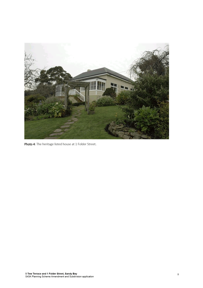
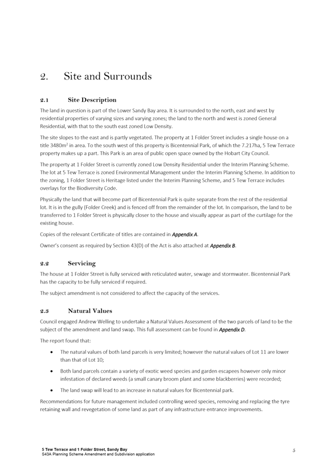
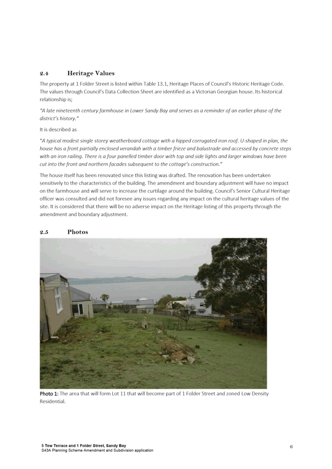
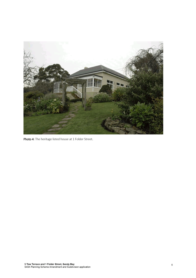
2.5. 1 Folder Street is a privately owned residential title that includes a single dwelling and outbuildings. The site is heritage listed under the Historic Heritage Code of the HIPS 2015.
2.6. 5 Tew Terrace is part of Council owned Bicentennial Park, and is used for public open space.
2.7. Surrounding uses are primarily residential.
2.8. The proposed amendments to the HIPS 2015 are appropriate for the following reasons:
2.8.1. There are benefits to the rezoning and subsequent ‘land swap’ for both the private owner and the Council. The privately owned land will achieve greater separation between existing buildings on the site and Bicentennial Park, and conversely Bicentennial Park will gain greater scope for future public access from Sandy Bay Road.
2.8.2. The rezoning/boundary adjustment will mean the privately owned land will be more able to contain the bushfire hazard management requirements for the dwelling without relying on maintenance of vegetation on Council land, which benefits both landowners.
2.8.3. The area of land within both zones (and subsequently both land titles if the boundary adjustment is approved) will remain the same, as the rezoned parcels are of the same area. As such, general development potential is not altered.
2.8.4. The parcels of land to be rezoned are visually and topographically more related to the zone that they will become following the rezoning.
2.8.5. The change to the boundary of the Biodiversity Protection Area Overlay to reflect to the zoning change is appropriate as it better reflects the potential environmental value of both parcels of land (although currently neither parcel has significant values).
2.8.6. The removal of the current CT reference in the heritage listing for 1 Folder Street is appropriate to ensure the heritage listing is not misleading, given the CT will change following the potential boundary adjustment. It would be undesirable for the listing to apply to land that was to become part of Bicentennial Park.
2.8.7. The rezoning is consistent with the Southern Tasmania Regional Land Use Strategy (STRLUS), the Objectives of the Land Use Planning and Approvals Act (LUPAA) and State Policies.
2.8.8. The amendments are considered to be minor in nature and are very unlikely to result in any negative consequences for either the subject titles or surrounding properties.
|
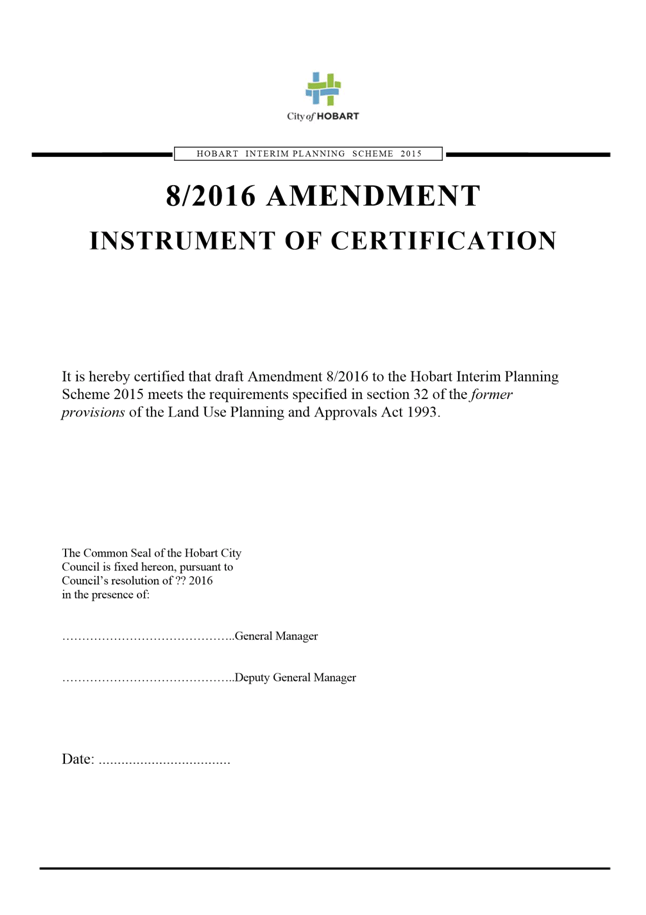
That: 1. Pursuant to Section 34(1) (b) of the former provisions of the Land Use Planning and Approvals Act 1993, the Council resolve to initiate amendments to the Hobart Interim Planning Scheme 2015 to: (i) rezone part of the property at 1 Folder Street to Environmental Management and part of the property at 5 Tew Terrace to Low Density Residential, as indicated on the plans provided in Attachment A; (ii) add the area rezoned to Environmental Management to the Biodiversity Protection Area Overlay and remove the area rezoned to Low Density Residential from the Biodiversity Protection Area Overlay, as indicated on the plans provided in Attachment A; (iii) remove the Certificate of Title number reference from the heritage listing for 1 Folder Street under Table E13.1 of the Historic Heritage Code (listing reference number 1159). 2. Pursuant to Section 35 of the former provisions of the Land Use Planning and Approvals Act 1993, the Council certify that the 8/2016 Amendment to the Hobart Interim Planning Scheme 2015 meets the requirements of Section 32 of the former provisions of the Land Use Planning and Approvals Act 1993 and authorise the General Manager and the Deputy General Manager to sign the Instrument of Certification (Attachment C). 3. Pursuant to Section 38 of the former provisions of the Land Use Planning and Approvals Act 1993, the Council place the 8/2016 Amendment to the Hobart Interim Planning Scheme 2015 on public exhibition for a 28 day period following certification. 4. Pursuant to Section 43A of the former provisions of the Land Use Planning and Approvals Act 1993, the Council grant a permit for Subdivision (Boundary Adjustment) at 1 Folder Street and 5 Tew Terrace, Sandy Bay, and a permit containing the conditions specified in Attachment B be issued.
|
4. Background
4.1. The land subject to the proposed rezoning comprises two titles under separate ownership in Lower Sandy Bay.
4.2. 1 Folder Street is a relatively large 3,480m2 heritage listed lot containing a single dwelling. It is Zoned Low Density Residential, with an approximately 19% slope to the east and south. The site primarily contains exotic garden vegetation, but also includes three large blue gum trees.
1 Folder Street is fully serviced with reticulated water, sewerage and stormwater.
4.3. 5 Tew Terrace is a large 72,170m2 parcel of council owned public open space (part of Bicentennial Park). This title, as well as the remainder of land within Bicentennial Park, is zoned Environmental Management.
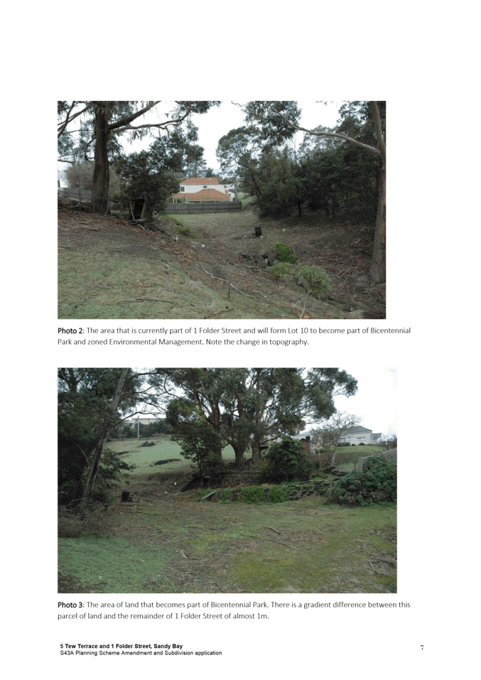
The title slopes at a gradient of approximately 32%, primarily to the south-west, and is largely vegetated other than a cleared area adjoining 1 Folder Street. It also includes a rivulet close to the boundary of 1 Folder Street.
5 Tew Terrace has the capacity to be fully serviced if required.
4.4. There are two covenants applicable to 5 Tew Terrace. One relates to conservation, and negotiations with the State and Federal governments have indicated that once the land swap is resolved, the covenant can be removed through the State Government’s Natural Values and Conservation Branch.
4.5. The second covenant prohibits the construction of residential and commercial buildings. After the land swap, this covenant could remain applicable to the area of land adhered to 1 Folder Street, restricting future development opportunities in this area of the property. Given the land swap is not for the intention of developing the relevant area of land, and given the size of the lot, it is not considered that the restriction would be overly onerous for the residential owners.
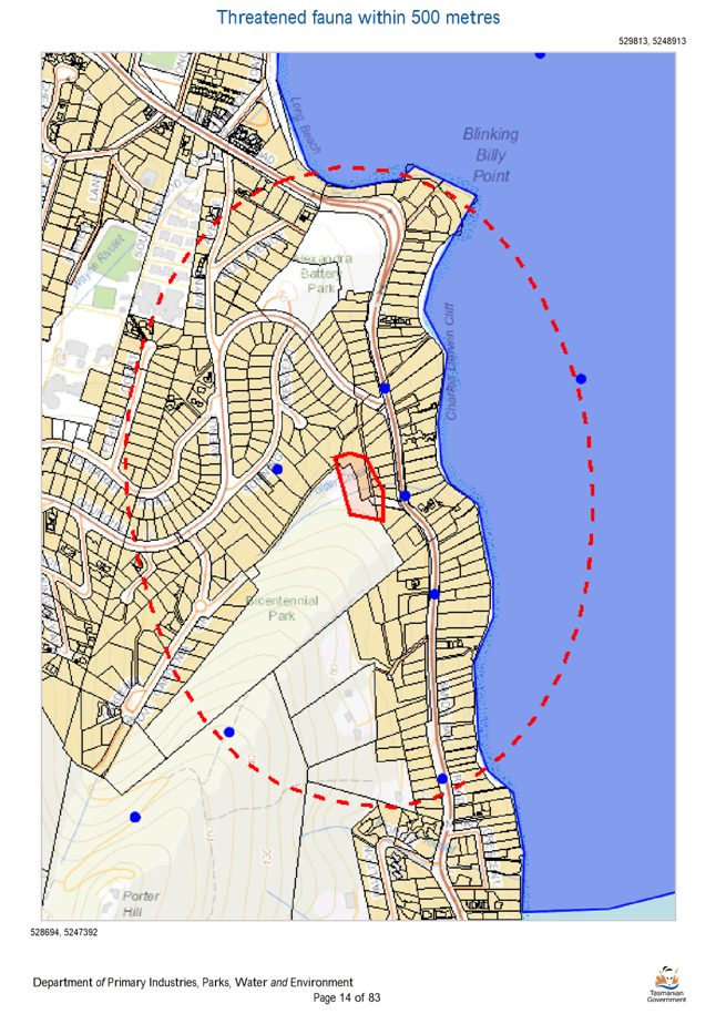
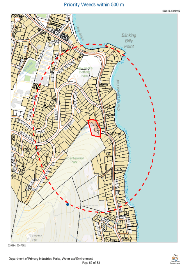
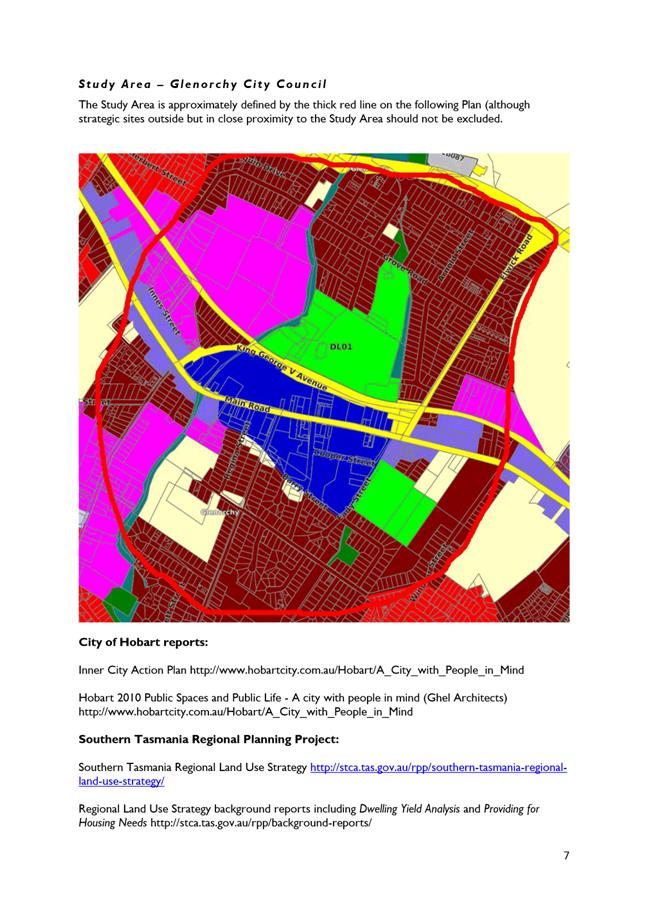
4.6. The area surrounding the two titles is primarily residential (Low Density Residential immediately surrounding the subject area, and General Residential to the north-west). To the south is the remainder of Bicentennial Park, and approximately 150m to the east is the River Derwent (see Figure 1 below).
4.7. A resolution was passed at the Council meeting of 23/5/2016 to proceed with the land exchange between 1 Folder Street and 5 Tew Terrace, and to grant landowner consent to lodge the S43A application. One objection in relation to this land exchange was received, but determined not to present ‘a strong rationale for the land exchange not to proceed’.

Figure 1: subject area (outlined in dotted blue) showing existing zoning (pink: Low Density Residential, blue-green: Environmental Management, red: General Residential).
Planning Scheme Provisions
4.8. The Zone Purpose Statements for the Low Density Residential Zone are:
To provide for residential use or development on larger lots in residential areas where there are infrastructure or environmental constraints that limit development.
To provide for non-residential uses that are compatible with residential amenity.
To encourage residential development that respects the neighbourhood character.
To provide a high standard of residential amenity.
To ensure that development respects the natural conservation values of the land and is designed to mitigate any visual impacts of development on public views.
4.9. Within the Low Density Residential Zone, a single dwelling or home-based business is no permit required, along with some other low impact uses. Other residential uses are permitted, as is Visitor accommodation. There are a small number of discretionary uses, including (but not limited to) Community meeting and entertainment, Domestic animal breeding, boarding or training and Sports and recreation.
4.10. The Zone Purpose Statements for the Environmental Management Zone are:
To provide for the protection, conservation and management of areas with significant ecological, scientific, cultural or aesthetic value, or with a significant likelihood of risk from a natural hazard.
To only allow for complementary use or development where consistent with any strategies for protection and management.
To facilitate passive recreational opportunities which are consistent with the protection of natural values in bushland and foreshore areas.
To recognise and protect highly significant natural values on private land.
To protect natural values in un-developed areas of the coast.
4.11. Within the Environmental Management Zone, the only no permit required uses are Natural and cultural values management and Passive recreation. There are a number of permitted uses (such as Community meeting and entertainment, Food services, Tourist operation, Visitor accommodation), however all of these uses are only permitted if a reserve management plan applies. There are a reasonable range of discretionary uses, including (but not limited to) Pleasure boat facility, Resource processing (if dependant on a coastal location), Tourist operation and Visitor accommodation.
5. Proposal and Implementation
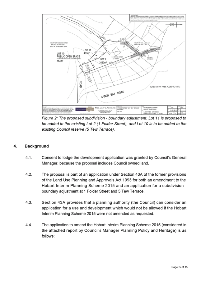
5.1. The proposal is to rezone a 463m2 section of 1 Folder Street Environmental Management, and a 463m2 section of 5 Tew Terrace Low Density Residential. It is also proposed that the Biodiversity Protection Area Overlay be added to the section of land to be rezoned Environmental Management and removed from the section of land to be rezoned Low Density Residential, and that the CT number be removed from the heritage listing for 1 Folder Street under Table E3.1 of the Historic Heritage Code. The zone and overlay changes are shown in Figures 2 and 3 below.
5.2. It is also proposed that planning approval be granted for a boundary adjustment to incorporate the rezoned areas into the adjoining lot with the corresponding zone. The resultant land size of both lots will not change. The permit application is submitted under S.43A of the former provisions of LUPAA. The former provisions of the Act are defined in Schedule 6 – Savings and Transitional Provisions of the Land Use Planning and Approvals Amendment (Tasmanian Planning Scheme Act) 2015 which commenced on 17 December 2015. An assessment of the S.43A application by a Development Appraisal Planner and the Senior Statutory Planner is provided in Attachment B.
5.3. In relation to 5.2 above, LUPAA allows for Council, after it has decided to initiate an amendment, to consider a permit application concurrently with the preparation of a requested amendment. Both the amendment and permit application would be advertised for public comment. If Council decides not to initiate the amendment requested there is no need to consider the planning permit application.
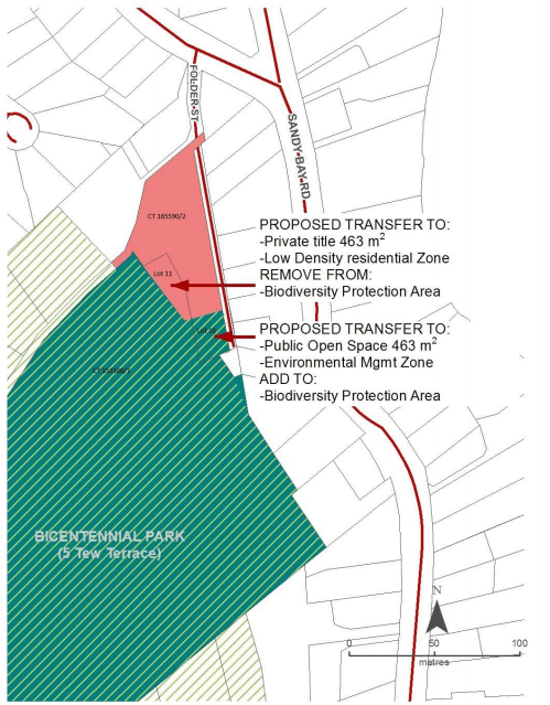
Figure 2: plan showing boundary adjustment, zoning change, and alterations to the Biodiversity Protection Area Overlay.
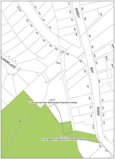
Figure 3: Plan showing resultant amendment to the Biodiversity Protection Area Overlay
Justification – Applicant’s Submission
5.4. The applicant considers that the requested amendment is justified for the following reasons:
5.4.1. The ‘land swap’ represents a positive outcome for both the private landowner, who will achieve greater separation from the rear of their dwelling to Bicentennial Park, and the Council, which will gain improved access prospects from Sandy Bay Road for potential future walkways or vehicle access ways.
5.4.2. Acquiring the land from 1 Folder Street would increase future opportunities for Council to develop basic park infrastructure for Bicentennial Park, which is desirable given the limited public access points to the park.
5.4.3. The change in the configuration of the residential land will also ensure the Bushfire Management requirements are more easily met by the owners, rather than being reliant on management within Council land.
5.4.4. Physically, the land that will become part of Bicentennial Park is quite separate from the remainder of the residential lot, as it is within a gully and fenced off from the rest of the lot. The land to be transferred to 1 Folder Street is physically closer to the house and appears visually to be part of the curtilage for the existing house.
5.4.5. The boundary adjustment will not result in increased development potential for either title, as the land areas will remain the same.
5.4.6. The amendment to the Biodiversity Protection Area Overlay is supported by a Natural Values Assessment, which concludes that the area to be joined to 1 Folder Street is cleared and contains no native vegetation, and that the area to be joined to 5 Tew Terrace contains no intact native vegetation but some remnant/regrowth native species.
5.4.7. While neither parcel of land to be rezoned has high conservation significance, the parcel with slightly higher vegetation value will be transferred to public ownership (and be covered by the Biodiversity Protection Overlay), and the parcel containing essentially no values will be transferred to private ownership and will not be covered by the overlay.
5.4.8. The proposed amendment is consistent with the Southern Tasmania Regional Land Use Strategy (STRLUS), specifically that it:
5.4.8.1. Manages biodiversity by including the parcel of land with higher natural values in the Environmental Management Zone and under the Biodiversity Protection Area Overlay, and removing the parcel with negligible natural values from that zone and overlay;
5.4.8.2. Enables a boundary adjustment that facilitates a more appropriate setback from reserved land and enables bushfire management to be contained within the residential lot’s boundaries.
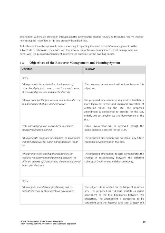
5.4.9. The proposed amendment meets the objectives of the Resource Management and Planning System and State Policies.
Justification - Comment
5.5. The applicant has submitted some valid reasons supporting the proposed rezoning.
5.6. The rezoning specifically allows for a boundary adjustment that results in improvements to both titles.
5.7. 1 Folder Street will gain more space between existing buildings on the lot and Bicentennial Park, and 5 Tew Terrace will gain greater future opportunities for park access from Sandy Bay Road.
5.8. The potential for simplification of the bushfire hazard management regime on the private lot (no longer relying on management on adjacent Council land) is beneficial to both the private landowner and Council.
5.9. The rezoning relates to two parcels of land that are equal in size, and therefore the overall development potential within the zones is essentially unaltered.
5.10. The parcels of land to be rezoned and ‘swapped’ are visually and topographically more related to the lots to which they will be adhered, and more representative of the new zone that will be applied.
5.11. Originally, the applicant was considering the S43A application in the view that it would be classed as a subdivision that did not meet Special Provision 9.3 of the HIPS 2015 which states:
9.3 Adjustment of a Boundary
9.3.1 An application for a boundary adjustment is permitted and a permit must be granted if:
(a) no additional lots are created;
(b) there is only a minor change to the relative size, shape and orientation of the existing lots;
(c) no setback from an existing building will be reduced below the applicable minimum setback requirement;
(d) no frontage is reduced below the applicable minimum frontage requirement; and
(e) no lot boundary that aligns with a zone boundary will be changed.
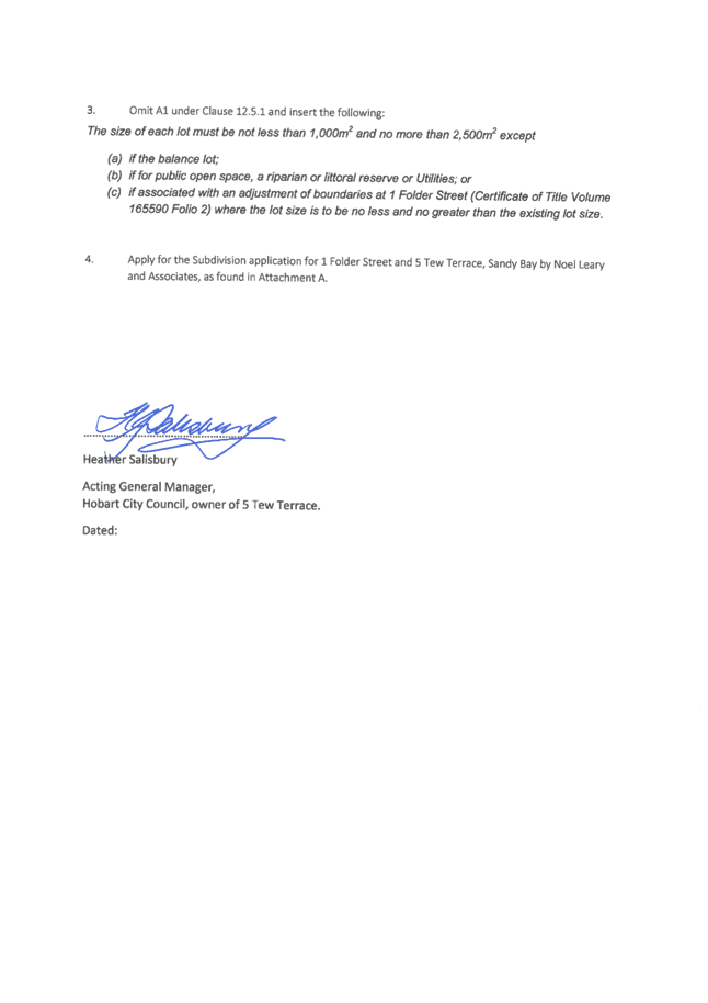
5.12. Development that does not meet Clause 9.3 must be considered against the subdivision standards of the relevant zones. Given the Low Density Residential Zone sets a lot size limit of no greater than 2,500m2, with no Performance Criteria, the applicant’s submission initially proposed that a specified departure be added to Clause 12.5.1 (Low Density Residential Zone Lot Design) as follows:
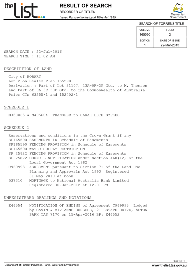
(c) if associated with an adjustment of boundaries at 1 Folder Street (Certificate of Title Volume 165590 Folio 2) where the lot size is to be no less and no greater than the existing lot size.
5.13. Subsequent discussions between the applicant and Council Officers confirmed, however, that the boundary adjustment could in fact meet the provisions of 9.3. The requirement of subclause 9.3 that was potentially unmet by the proposal was 9.3.1 (e), which requires that no lot boundary that aligns with a zone boundary will be changed. The boundary adjustment does change the lot boundaries over the original zone boundary, however as S43A development applications are required to be considered as if the proposed amendment (rezoning) has been approved, it is considered that 9.3.1 (e) is in fact satisfied.
5.14. Therefore, the development application will be permitted and not subject to the subdivision standards of the zones. As such, a specified departure in the subdivision standards of the Low Density Residential Zone is unnecessary, which is confirmed in a follow-up letter from the applicant.
5.15. The second part of the amendment is to amend the boundary of the Biodiversity Protection Area Overlay so that it still follows the zone boundary. This means the overlay will be removed from the area to be added to 1 Folder Street, and applied to the area to be added to 5 Tew Terrace.
5.16. Following the boundary adjustment, it is considered logical to remove the Biodiversity Protection Area Overlay from the privately owned title, and apply it to the public open space. This corresponds with the current application of the overlay, where it is applied to the remainder of Bicentennial Park but not the remainder of the privately owned 1 Folder Street.
5.17. The Natural Values Assessment submitted with the application also recommends active management of the area to be transferred to Bicentennial Park following the exchange, including weed control, removal of a tyre retaining wall and revegetation. This would be likely to increase the natural values of the area and make it increasingly suitable to be considered under the Biodiversity Code.
5.18. A potential issue arising from the amended zoning and boundary adjustment relates to the heritage listing of 1 Folder Street. Under the Historic Heritage Code of the HIPS, 1 Folder Street includes a reference to the current Certificate of Title (CT) number (63255/1).
5.19. If the boundary adjustment is approved, the CT number will change, and will refer to the new title boundaries. If the existing number in the listing for 1 Folder Street is retained, it will refer to the historical title boundary. This could be problematic given part of the listing would then extend into 5 Tew Terrace, which is not intended to be heritage listed.
5.20. It is not known what the new CT number will be following the boundary adjustment, and therefore this cannot be inserted. It is considered most logical to remove the current CT reference. The new reference can be added through a future scheme amendment, but in the interim the address will be the primary identifier.
5.21. The rezoning proposal is consistent with the STRLUS. In addition to the policies referred to by the applicant (specifically relating to biodiversity and bushfire management), it is also considered that the proposal satisfies the following additional policies:
ROS 1.5: Ensure residential areas, open spaces and other community destinations are well connected with a network of high-quality walking and cycling routes
Though no additional links to the park are proposed at this stage, one of the intended outcomes of the rezoning and boundary adjustment are to enable better future public links between Sandy Bay Road and Bicentenary Park.
5.22. The rezoning is considered to be minor in nature, and unlikely to have any negative impacts on either the subject titles or surrounding properties.
6. Strategic Planning and Policy Considerations
6.1. The proposed amendment is consistent with the objectives of the Capital City Strategic Plan 2015-2025 in regard to Strategic Objective 2.3 – ‘City and regional planning ensures quality design, meets community needs and maintains residential amenity’.
7. Financial Implications
7.1. The proposed planning scheme amendment should not result in any additional significant Council expenditure.
8. Legal, Risk and Legislative Considerations
8.1. The Land Use Planning and Approvals Act 1993 (LUPAA) requires that planning scheme amendments must seek to further the objectives of Schedule 1 of the Act and be prepared in accordance with State Policies.
8.2. The objectives of the Act require use and development to occur in a fair, orderly and sustainable manner and for the planning process to facilitate economic development in accordance with the other Schedule 1 objectives.
8.3. It is considered that the proposed amendment meets the objectives of LUPAA, in particular it:
8.3.1. Assists sound strategic planning by not prejudicing the achievement of the relevant Zone Objectives or the STRLUS objectives;
8.3.2. Is consistent with the objective to establish a system of planning instruments to be the principal way of setting objectives, policies and controls for the use, development and protection of land;
8.3.3. Provides greater flexibility to address changes in local environmental, social and economic circumstances;
8.3.4. Allows for a more logical lot arrangement to better reflect land use;
8.3.5. Is consistent with the objective to provide for the consolidation of approvals for land use and development;
8.3.6. Facilitates the integration of compatible and complementary land use activities in a managed and safe environment;
8.3.7. Provides for the exercise of greater flexibility to fully consider the capability of the land.
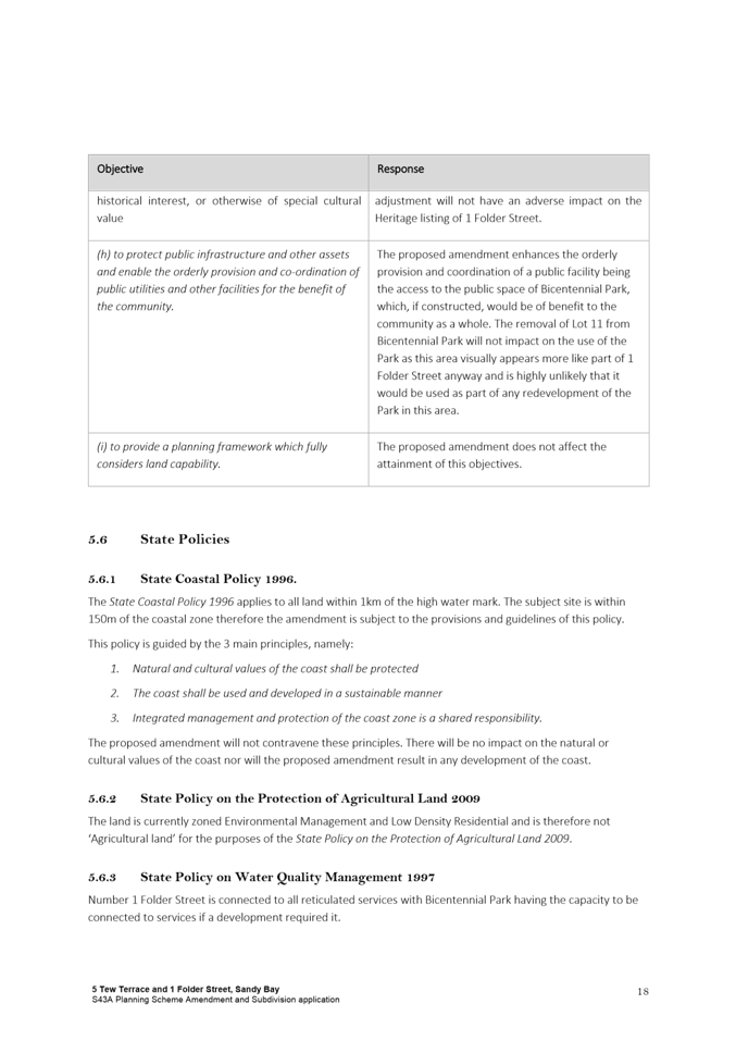
8.4. The relevant State Policy in this instance is the State Coastal Policy 1996. The subject land is within 1km of the high water mark, and therefore this Policy applies. The 3 main principles guiding the Policy are:
1. Natural and cultural values of the coast shall be protected
2. The coast shall be used and developed in a sustainable manner
3. Integrated management and protection of the coast zone is a shared responsibility.
The proposed amendments will be consistent with these principles. There will be no additional development, or increase in general development potential, and therefore there is considered to be no impact on the natural or cultural values of the coast.
8.5. In terms of the State Policy on Water Quality Management 1997, the residential title at 1 Folder Street is fully connected to reticulated services and Bicentennial Park has the capacity to be connected if required. As a result of the amendment, a gully leading to a creek and stormwater catchment will be transferred to public ownership, which is a preferable outcome in terms of future management. The proposal therefore complies with the objectives of this policy.
8.6. S32(e) of the former provisions of LUPAA requires that planning scheme amendments must avoid the potential for land use conflicts in adjacent planning scheme areas. The proposed amendment complies with this provision as the rezoning and subsequent boundary adjustment improves the relationship between a privately owned title and a publicly owned park. The private owners will gain more separation from the public space and will be able to better manage bushfire management within their title boundaries, and the park will gain greater potential for public access. It is not considered that the minor change will impact on any other adjoining land.
8.7. S32(f) of the former provisions of LUPAA requires that planning scheme amendments must have regard to the impact that the use and development permissible under the amendment will have on the use and development of the region as an entity in environmental, economic and social terms. The size, location and configuration of the land proposed for rezoning is such that it will not have any regional implications.
9. Environmental Considerations
9.1. Environmental considerations have been addressed as part of the assessment of this amendment. It is considered that the proposed rezoning will result in a slightly more positive environmental outcome as land with virtually no environmental value will be removed from the Biodiversity Protection Area Overlay, and land with slightly more value will be included under this overlay and be transferred to public ownership.
10. Social and Customer Considerations
10.1. The proposal is not considered to have any negative impact on social inclusion.
11. Marketing and Media
11.1. There are no marketing or branding implications of this amendment.
12. Community and Stakeholder Engagement
12.1. Council has requested that reports which recommend the initiation of planning scheme amendments address the need to conduct a public meeting or forum to explain the proposed amendments and also outline the explanatory information to be made available. These are addressed below:
12.1.1. It is not considered that a public forum is necessary to explain the proposed amendment to the public as it is relatively simple and self explanatory.
12.1.2. The following information will be made available on the website: a copy of this report, a copy of the formal amendment document and the applicant’s submission.
12.2. Council will have the opportunity to recommend to the Tasmanian Planning Commission modifications or refusal of the permit or amendment after the 28 day public advertising period.
13. Delegation
13.1. Delegation rests with the Council.
As signatory to this report, I certify that, pursuant to Section 55(1) of the Local Government Act 1993, I hold no interest, as referred to in Section 49 of the Local Government Act 1993, in matters contained in this report.
|
James McIlhenny Manager Planning Policy and Heritage |
|
Date: 7 December 2016
File Reference: F16/99289
Attachment a: Attachment
A - Applicant Submission ⇩ ![]()
Attachment
b: Attachment
B - Development Appraisal Report ⇩ ![]()
Attachment
c: Attachment
C - Instrument of Certification ⇩ ![]()
|
Item No. 7.1.2 |
Agenda (Open Portion) City Planning Committee Meeting - 12/12/2016 |
Page 150 ATTACHMENT a |


|
Item No. 7.1.2 |
Agenda (Open Portion) City Planning Committee Meeting - 12/12/2016 |
Page 191 ATTACHMENT a |
|
Item No. 7.1.2 |
Agenda (Open Portion) City Planning Committee Meeting - 12/12/2016 |
Page 192 ATTACHMENT a |


|
Item No. 7.1.2 |
Agenda (Open Portion) City Planning Committee Meeting - 12/12/2016 |
Page 295 ATTACHMENT b |
|
Item No. 7.1.2 |
Agenda (Open Portion) City Planning Committee Meeting - 12/12/2016 |
Page 313 ATTACHMENT b |
|
Item No. 7.1.2 |
Agenda (Open Portion) City Planning Committee Meeting - 12/12/2016 |
Page 314 ATTACHMENT b |


|
Item No. 7.1.2 |
Agenda (Open Portion) City Planning Committee Meeting - 12/12/2016 |
Page 419 ATTACHMENT b |
|
Item No. 7.1.2 |
Agenda (Open Portion) City Planning Committee Meeting - 12/12/2016 |
Page 421 ATTACHMENT b |

|
Item No. 7.1.2 |
Agenda (Open Portion) City Planning Committee Meeting - 12/12/2016 |
Page 424 ATTACHMENT b |
|
Item No. 7.1.2 |
Agenda (Open Portion) City Planning Committee Meeting - 12/12/2016 |
Page 428 ATTACHMENT b |
|
Item No. 7.1.2 |
Agenda (Open Portion) City Planning Committee Meeting - 12/12/2016 |
Page 431 ATTACHMENT b |
|
Item No. 7.1.2 |
Agenda (Open Portion) City Planning Committee Meeting - 12/12/2016 |
Page 432 ATTACHMENT b |
|
Item No. 7.1.2 |
Agenda (Open Portion) City Planning Committee Meeting - 12/12/2016 |
Page 445 ATTACHMENT c |
|
Agenda (Open Portion) City Planning Committee Meeting |
Page 446 |
|
|
|
12/12/2016 |
|
8 Reports
8.1 Infill Development Pilot Project
File Ref: F16/134516; S32-013-04
Report of the Manager Planning Policy and Heritage of 7 December 2016 and attachments.
Delegation: Council
|
Item No. 8.1 |
Agenda (Open Portion) City Planning Committee Meeting |
Page 447 |
|
|
12/12/2016 |
|
REPORT TITLE: Infill Development Pilot Project
REPORT PROVIDED BY: Manager Planning Policy and Heritage
1. Report Purpose and Community Benefit
1.1. This report informs Council of the outcomes of the Infill Development Pilot Project and seeks Council’s endorsement of the release of the report to the relevant landowners.
1.2. The community benefits of encouraging of infill residential development include improving people’s access to employment, education and training and making more effective use of existing services and infrastructure such as public transport and schools.
2. Report Summary
2.1. The City of Hobart has participated in a joint project with the Department of State Growth and the Glenorchy City Council to identify priority sites for infill development within the Cities of Hobart and Glenorchy and to undertake a strategic planning process around the development of these sites for infill development.
2.2. The project stems from the recommended actions in the Infill Development within Greater Hobart Report commissioned by the Department of State Growth as part of the Transit Corridor Project in 2011.
2.3. The project was conducted in 2 stages. Stage 1 identified 6 priority sites suitable for infill development including residential and/or mixed use in the Study Area based on a number of criteria (see Stage 1 Report Section 4 - Attachment B). The priority sites were to represent realistic, achievable infill development opportunities as well as a variety in the type and scale of development outcomes.
2.4. Stage 2 of the project involved the development of high level structure plans for the 6 priority sites to provide some development certainty. The structure plans take into account site context, site characteristics including land capability, site opportunities and infrastructure. They also detail desired future use and outline appropriate levels of development form, e.g. density, height and siting.
2.5. The Stage 2 report (Attachment C) also identifies the need for changes to planning controls and provides advice on the feasibility of developing sites including market advice on the type of development and development options. It also aims to encourage land owners to consider redevelopment of their land for infill residential purposes.
2.6. The 3 priority sites identified in Hobart do not require any changes to the Planning Scheme in order for the development concept to proceed, and there are no servicing or infrastructure constraints that would prevent development at the densities suggested. The market assessment has concluded that for each of the sites there would be interest in the private market given the potential for development profit.
2.7. The project provides a useful methodology for the identification of sites suitable for infill development and demonstrates that in Hobart the Hobart Interim Planning Scheme 2015 facilitates appropriate infill residential development.
|
That: (i) Council note the outcomes of the Infill Development Pilot Project and endorse the release of the project reports, prepared by Emma Riley and Associates Pty Ltd, to the landowners of the 3 priority sites identified in Hobart.
|
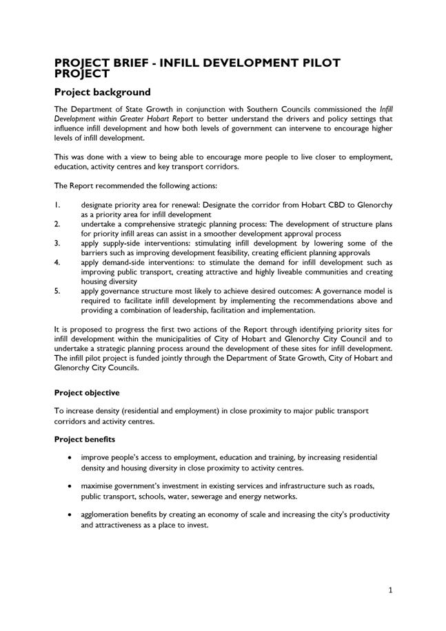
Background3.1. The City of Hobart has participated in a joint project with the Department of State Growth and the Glenorchy City Council to identify priority sites for infill development within the Cities of Hobart and Glenorchy and to undertake a strategic planning process around the development of these sites for infill development.
3.2. The project stems from the recommended actions in the Infill Development within Greater Hobart Report commissioned by the Department of State Growth as part of the Transit Corridor Project in 2011.
3.3. The project was undertaken by Emma Riley and Associates in association with Knight Frank and was jointly funded by the Department of State Growth ($50,000 contribution) and the Hobart ($10,000) and Glenorchy City Councils ($5000). A copy of the project brief is provided in Attachment A.
4. Proposal and Implementation
4.1. It is proposed that Council note the outcomes of the Infill Development Pilot Project and endorse the release of the report to the landowners of the 3 priority sites identified in Hobart.
4.2. The objective of the Infill Development Pilot Project was to facilitate increased density (residential and employment) in close proximity to major public transport corridors and activity centres with the benefits of this being to:
4.2.1. improve people’s access to employment, education and training, by increasing residential density and housing diversity in close proximity to activity centres.
4.2.2. maximise government’s investment in existing services and infrastructure such as roads, public transport, schools, water, sewerage and energy networks.
4.2.3. agglomeration benefits by creating an economy of scale and increasing the city’s productivity and attractiveness as a place to invest.
4.3. The project was conducted in 2 stages. Stage 1 identified 6 priority sites suitable for infill development including residential and/or mixed use in the Study Area based on a number of criteria (see Stage 1 Report Section 4 - Attachment B). The priority sites were to represent realistic, achievable infill development opportunities as well as a variety in the type and scale of development outcomes.
4.4. Stage 2 of the project involved the development of high level structure plans for the 6 priority sites to provide some development certainty. The structure plans take into account site context, site characteristics including land capability, site opportunities and infrastructure. They also detail desired future use and outline appropriate levels of development form, e.g. density, height and siting.
4.5. The Stage 2 report (Attachment C) also identifies the need for changes to planning controls and provides advice on the feasibility of developing sites including market advice on the type of development and development options.
4.6. The Stage 2 report aims to encourage land owners to consider redevelopment of their land for infill residential purposes. Each site development plan therefore presents a realistic and practical option or vision for its redevelopment taking into account:
4.6.1. Existing land use, development and tenure;
4.6.2. Infrastructure capacity;
4.6.3. Market and demand considerations for its location;
4.6.4. Environmental, heritage or urban design considerations; and
4.6.5. Existing planning scheme requirements, including what could be achieved through a discretionary pathway.
4.7. The 6 priority sites identified are:
4.7.1. 27-35 Tasma Street, North Hobart;
4.7.2. 66 Burnett Street, North Hobart;
4.7.3. 143-145 New Town Road, New Town;
4.7.4. 60-62 Hopkins Street (including 18 Sunderland Street), Moonah;
4.7.5. 97A Grove Road, Glenorchy; and
4.7.6. 22 Wrights Avenue, Glenorchy (also known as McKays Timber Mill site)
4.8. The 3 priority sites identified in Hobart do not require any changes to the Planning Scheme in order for the development concept to proceed, and there are no servicing or infrastructure constraints that would prevent development at the densities suggested. The market assessment has concluded that for each of the sites there would be interest in the private market given the potential for development profit.
4.9. The Glenorchy sites will require some planning scheme amendments to facilitate infill residential development and possible financial returns are generally marginal at present. The McKays Timber site in Glenorchy is a large site that would need to be developed in stages due to its scale.
4.10. In relation to the 3 sites identified in Hobart implementation of any infill development proposal will be up to each individual land owner should they wish to do so. It is proposed that Council officers provide each of the land owners with a briefing in relation to the outcomes of the Stage 2 report.
5. Strategic Planning and Policy Considerations
5.1. The outcomes of the Infill Development Pilot Project are consistent with the objectives of the Capital City Strategic Plan 2015-2025 in regard to Goal 2 – Urban Management.
6. Financial Implications
6.1. Funding Source and Impact on Current Year Operating Result
6.1.1. No impact on current year operating result expected.
7. Legal, Risk and Legislative Considerations
7.1. The Infill Development Pilot Project reports are being issued with the following disclaimer: “While every responsible effort has been made to ensure that this document is accurate and complete, Emma Riley & Associates, Knight Frank, Cumulus Studio, Playstreet Landscape Architecture & Urban Design and WT Partnership, Department of State Growth, Glenorchy City Council and Hobart City Council do not warrant or represent that the information contained is free from errors or omissions and disclaim any and all liability to any person in respect of anything or the consequences of anything done or omitted to be done in reliance or upon the whole or any part of this document”.
7.2. The onus is on the landowners or future applicants to undertake their own investigations to determine the feasibility or otherwise of the development concepts suggested in the report.
7.3. Any future applications for development of the sites identified in the report will be subject to the provisions of the Land Use Planning and Approvals Act 1993 and the Hobart Interim Planning Scheme 2015.
8. Delegation
8.1. Council.
As signatory to this report, I certify that, pursuant to Section 55(1) of the Local Government Act 1993, I hold no interest, as referred to in Section 49 of the Local Government Act 1993, in matters contained in this report.
|
James McIlhenny Manager Planning Policy and Heritage |
|
Date: 7 December 2016
File Reference: F16/134516; S32-013-04
Attachment a: Attachment
A Project Brief ⇩ ![]()
Attachment b: Attachment B Stage 1 report (Under separate cover) ⇨
Attachment c: Attachment C Stage 2 report (Under separate cover) ⇨
|
Item No. 8.1 |
Agenda (Open Portion) City Planning Committee Meeting - 12/12/2016 |
Page 453 ATTACHMENT a |
|
Agenda (Open Portion) City Planning Committee Meeting |
Page 460 |
|
|
|
12/12/2016 |
|
8.2 Battery Point Advisory Committee - Re-appointment of Expiring Memberships 2016
File Ref: F16/128862; 32-2-5
Report of the Director City Planning of 1 December 2016.
Delegation: Council
|
Item No. 8.2 |
Agenda (Open Portion) City Planning Committee Meeting |
Page 461 |
|
|
12/12/2016 |
|
REPORT TITLE: Battery Point Advisory Committee - Re-appointment of Expiring Memberships 2016
REPORT PROVIDED BY: Director City Planning
1. Report Purpose and Community Benefit
1.1. The purpose of this report is to seek approval for the appointment of members to the Battery Point Advisory Committee (BPAC) in accordance with Part 13.4 of the Battery Point Planning Scheme 1979 (BPPS).
1.2. With the introduction of the Hobart Interim Planning Scheme 2015 (HIPS) on 20 May 2015, it is proposed to re-appoint two of the current members whose terms are otherwise due to expire on 31 December 2016, and note one new vacancy.
2. Report Summary
2.1. The BPPS calls for the Council to appoint an honorary committee to be known as the Battery Point Advisory Committee (BPAC).
2.2. In addition to the Chairman (Lord Mayor or his/her nominee, currently being the Chairman of the City Planning Committee), there are 7 members of the Committee, each appointed for a two year term.
2.3. Three positions on the Committee are due to expire on 31 December 2016:
2.3.1. Mr Warwick Oakman, being a nominee of the National Trust of Australia (Tas) Inc.;
2.3.2. Mr Brendan Connolly, being a resident of that part of the “District” south of Quayle Street; and
2.3.3. Mr Bruce Churchill, being a person with expertise in town planning or architecture or landscape planning or urban history or related fields.
2.4. Given the HIPS has been implemented and there are limited number of applications remaining to be determined by BPAC, it is proposed not to advertise the pending vacancies.
2.5. Both Mr Oakman and Mr Churchill have agreed, in-principal, to be re-appointed should the Council endorse their re-appointment. However, Mr Connolly has advised that he is unable to be re-appointed.
2.6. It is proposed that the Council re-appoint the two current members who have agreed to be re-appointed in principle, and note that one position will remain vacant after 31 December 2016.
|
That: 1. The following current members of the Battery Point Advisory Committee, whose terms are due to expire on 31 December 2016, be re-appointed for a further two year period, or until such time as the Battery Point Planning Scheme 1979 ceases to exist, whichever occurs first: (i) Mr Warwick Oakman, being a nominee of the National Trust of Australia (Tas) Inc; and (ii) Mr Bruce Churchill, being a person with expertise in town planning or architecture or landscape planning or urban history or related fields. 2. The Council note the vacancy of the position held by Mr Brendan Connolly, being a resident of that part of the “District” south of Quayle Street, as of 1 January 2017; 3. The Council note that upon the determination of the last of the validly received applications under the Battery Point Planning Scheme 1979, the Battery Point Advisory Committee will cease to exist.
|
4. Background
4.1. The BPPS calls for the Council to appoint an honorary committee to be known as the Battery Point Advisory Committee (BPAC).
4.2. In addition to the Chairman (Lord Mayor or his/her nominee, currently being the Chairman of the City Planning Committee), there are 7 members of the Committee, each appointed for a two year term.
4.3. Three positions on the Committee are due to expire on 31 December 2016:
4.3.1. Mr Warwick Oakman, being a nominee of the National Trust of Australia (Tas) Inc.;
4.3.2. Mr Brendan Connolly, being a resident of that part of the “District” south of Quayle Street; and
4.3.3. Mr Bruce Churchill, being a person with expertise in town planning or architecture or landscape planning or urban history or related fields.
4.4. Two positions held on the Committee were previously re-appointed for a further term of two years, and now expire on 31 December 2017:
4.4.1. Mr Robert Vincent, being a nominee of the Battery Point Sullivans Cove Community Association; and
4.4.2. Mr Tom O’Connor, being a person with expertise in town planning or architecture or landscape planning or urban history or related fields who shall be a resident of the “District”.
4.5. Two other positions on the Committee currently remain vacant:
4.5.1. The Battery Point Slipyards owners/operators position remains vacant due to no nominations being received over the last several years; and
4.5.2. One position for a nominee being a person representing an organisation representing business interests operating within the “District”, where the Council is satisfied that an organisation has been established representing those interests, remains vacant as the Battery Point Business Association Inc. has previously advised this Group is no longer active.
4.6. The BPPS does not define how members of the Committee are to be sought or appointed, only that the positions be appointed for a two year period.
4.7. Under normal circumstances, advertisements seeking nominations to fill the three vacancies expiring 31 December 2016 would be placed in the newspaper and relevant stakeholder groups advised.
4.8. However, the HIPS was declared by the Minister for Planning, and replaced the BPPS on 20 May 2015. The BPAC will cease to exist once all those applications validly lodged under the BPPS as at 19 May 2015 have been dealt with, as the HIPS does not contain provision for an advisory committee in Battery Point.
4.9. Given the HIPS has been implemented and there are limited number of applications remaining to be determined by BPAC, it is proposed not to advertise the pending vacancies, but to seek re-appointment of two of the current members, and note the additional vacancy that will exist post 31 December 2016.
5. Proposal and Implementation
5.1. With the endorsement of the Council, the following two members will be re-appointed for a further two year period or until the last of the validly received applications under the BPPS has been determined, whichever occurs first:
5.1.1. Mr Warwick Oakman, being a nominee of the National Trust of Australia (Tas) Inc;
5.1.2. Mr Bruce Churchill, being a person with expertise in town planning or architecture or landscape planning or urban history or related fields.
5.2. An additional vacancy would be created, being the member that is a resident of that part of the “District” south of Quayle Street.
6. Strategic Planning and Policy Considerations
6.1. The review and re-appointment of the members of BPAC assists the Council to meet its obligations contained within the Capital City Strategic Plan 2015-2025 under Goal 2 – Urban Management, Strategic Objective 2.3 – City and regional planning ensures quality design, meets community needs and maintains residential amenity.
7. Financial Implications
7.1. Funding Source and Impact on Current Year Operating Result
7.1.1. The BPAC is an honorary committee with no sitting fees applicable to members.
7.2. Impact on Future Years’ Financial Result
7.2.1. Not applicable.
7.3. Asset Related Implications
7.3.1. Not applicable.
8. Legal, Risk and Legislative Considerations
8.1. There is no legal, risk or additional legislative considerations associated with this report.
9. Community and Stakeholder Engagement
9.1. The three current members were consulted. Mr Oakman and Mr Churchill have agreed in-principal to be re-appointed, should the Council endorse their re-appointment. However, Mr Connolly has advised that he is unable to be re-appointed.
10. Delegation
10.1. This matter is delegated to the Council for consideration.
As signatory to this report, I certify that, pursuant to Section 55(1) of the Local Government Act 1993, I hold no interest, as referred to in Section 49 of the Local Government Act 1993, in matters contained in this report.
|
Neil Noye Director City Planning |
|
Date: 1 December 2016
File Reference: F16/128862; 32-2-5
|
Item No. 8.3 |
Agenda (Open Portion) City Planning Committee Meeting |
Page 466 |
|
|
12/12/2016 |
|
8.3 Petition – Traffic Hazard -
47 Fisher Avenue, Sandy Bay - PLN-16-00658-01
File Ref: F16/135101
Report of the Manager Development Appraisal of 7 December 2016 and attachments.
Delegation: Committee
|
Item No. 8.3 |
Agenda (Open Portion) City Planning Committee Meeting |
Page 467 |
|
|
12/12/2016 |
|

Memorandum: City Planning Committee
Petition – Traffic Hazard -
47 Fisher Avenue, Sandy Bay - PLN-16-00658-01
Background
At its meeting of 10 October 2016, the Council was presented with a petition from Mrs Anne Francis of 49 Fisher Avenue, Sandy Bay in relation to the abovementioned planning application at 47 Fisher Avenue, Sandy Bay.
The subject
matter of the petition stated that a traffic hazard would occur on
47 Fisher Avenue as a result of the seven cars associated with the
inappropriate development on that site utilising a single lane to access Fisher
Avenue. The action sought by the petitioners was that permission for the
developer to build three double-storey units on the internal block at 47 Fisher
Avenue be denied. There were 60 signatories to the petition.
Discussion
Aldermen may recall that the planning application proposing the development in question at 47 Fisher Avenue was also considered by the Council at its meeting of 10 October 2016, and that it was approved subject to conditions.
The access to the site was assessed against relevant planning scheme provisions as part of the officer consideration of the application. The access was found to be acceptable subject to standard conditions requiring the provision of further design detail.
Although Council’s approval of the proposal was appealed by Mrs Francis, that appeal has since been withdrawn.
Conclusion
Contrary to the subject matter of the petition presented by Mrs Anne Francis at the Council meeting of 10 October 2016, Council officers consider the vehicular access to the three dwellings approved for construction at 47 Fisher Avenue to be acceptable, subject to conditions.
The planning application proposing the development was approved by Council at its meeting of 10 October 2016, and a subsequent appeal has been withdrawn. No further action is considered necessary.
The petitioner will be advised.
|
That: 1. The information be received and noted. 2. The petitioner be advised of the outcome of the appeal.
|
As signatory to this report, I certify that, pursuant to Section 55(1) of the Local Government Act 1993, I hold no interest, as referred to in Section 49 of the Local Government Act 1993, in matters contained in this report.
|
Rohan Probert Manager Development Appraisal |
|
Date: 7 December 2016
File Reference: F16/135101
Attachment a: PLN-16-00658-01
- 47 Fisher Avenue - SAN~BAY - Petition presented to Alderman Briscoe - Anne Francis
- Received 05102016 ⇩ ![]()
|
Item No. 8.3 |
Agenda (Open Portion) City Planning Committee Meeting - 12/12/2016 |
Page 469 ATTACHMENT a |


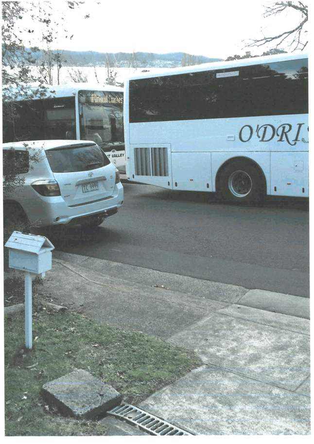

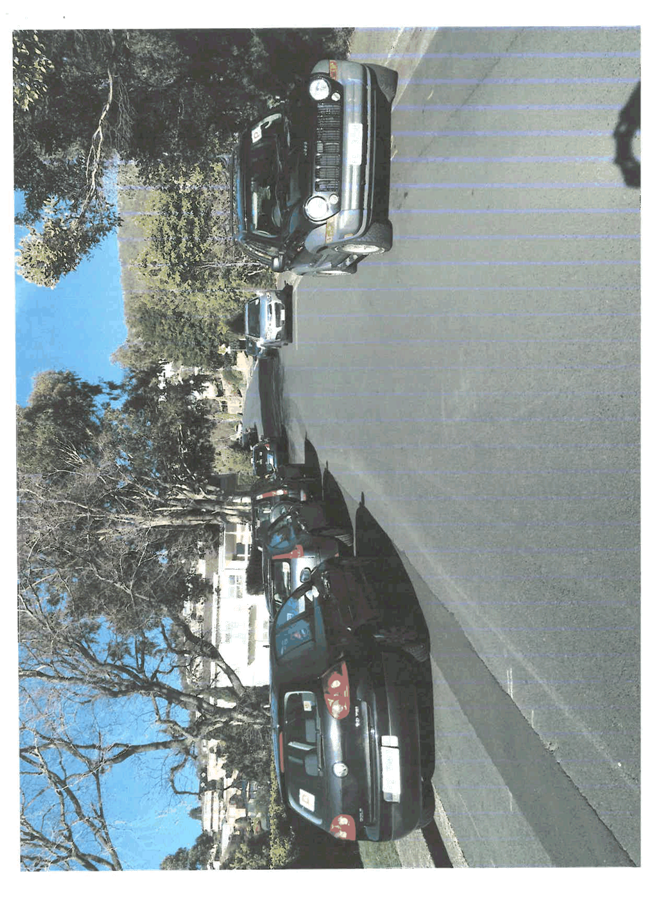
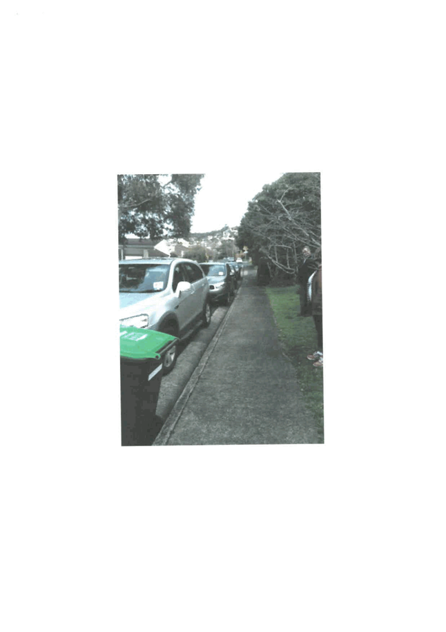
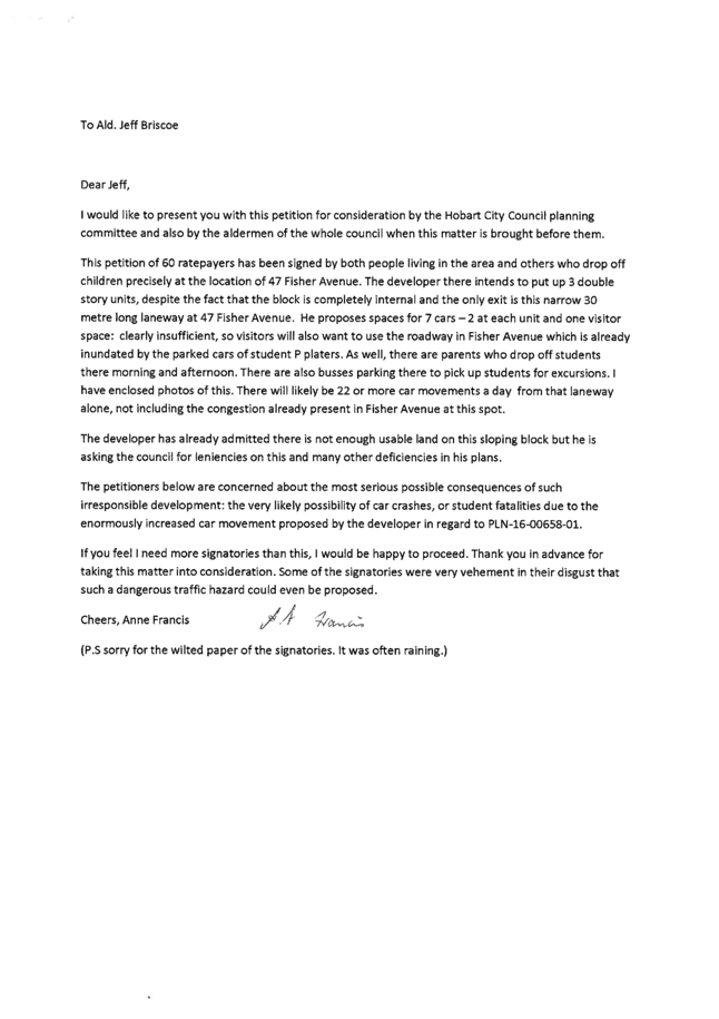
|
Agenda (Open Portion) City Planning Committee Meeting |
Page 480 |
|
|
|
12/12/2016 |
|
8.4 City Planning - Advertising List
File Ref: F16/136568
Report of the Director City Planning of 7 December 2016 and attachments.
Delegation: Committee
|
Item No. 8.4 |
Agenda (Open Portion) City Planning Committee Meeting |
Page 481 |
|
|
12/12/2016 |
|
Memorandum: City Planning Committee
City Planning - Advertising List
Attached is the advertising list for the period 22 November – 12 December 2016
|
That: 1. That the information be received and noted.
|
As signatory to this report, I certify that, pursuant to Section 55(1) of the Local Government Act 1993, I hold no interest, as referred to in Section 49 of the Local Government Act 1993, in matters contained in this report.
|
Neil Noye Director City Planning |
|
Date: 7 December 2016
File Reference: F16/136568
Attachment a: City
Planning - Advertising List ⇩ ![]()
|
Item No. 8.4 |
Agenda (Open Portion) City Planning Committee Meeting - 12/12/2016 |
Page 482 ATTACHMENT a |
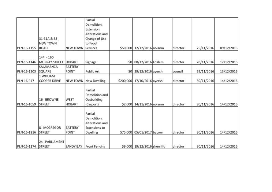
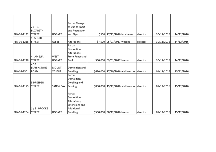
|
Agenda (Open Portion) City Planning Committee Meeting |
Page 486 |
|
|
|
12/12/2016 |
|
8.5 Delegated Decisions Report (Planning)
File Ref: F16/136978
Report of the Director City Planning of 7 December 2016 and attachments.
Delegation: Committee
|
Item No. 8.5 |
Agenda (Open Portion) City Planning Committee Meeting |
Page 487 |
|
|
12/12/2016 |
|
Memorandum: City Planning Committee
Delegated Decisions Report (Planning)
Attached is the delegated planning decisions for the period 22 November until 6 December 2016.
|
That: 1. That the information be received and noted.
|
As signatory to this report, I certify that, pursuant to Section 55(1) of the Local Government Act 1993, I hold no interest, as referred to in Section 49 of the Local Government Act 1993, in matters contained in this report.
|
Neil Noye Director City Planning |
|
Date: 7 December 2016
File Reference: F16/136978
Attachment a: Delegated
decisions report (planning) ⇩ ![]()
|
Item No. 8.5 |
Agenda (Open Portion) City Planning Committee Meeting - 12/12/2016 |
Page 488 ATTACHMENT a |
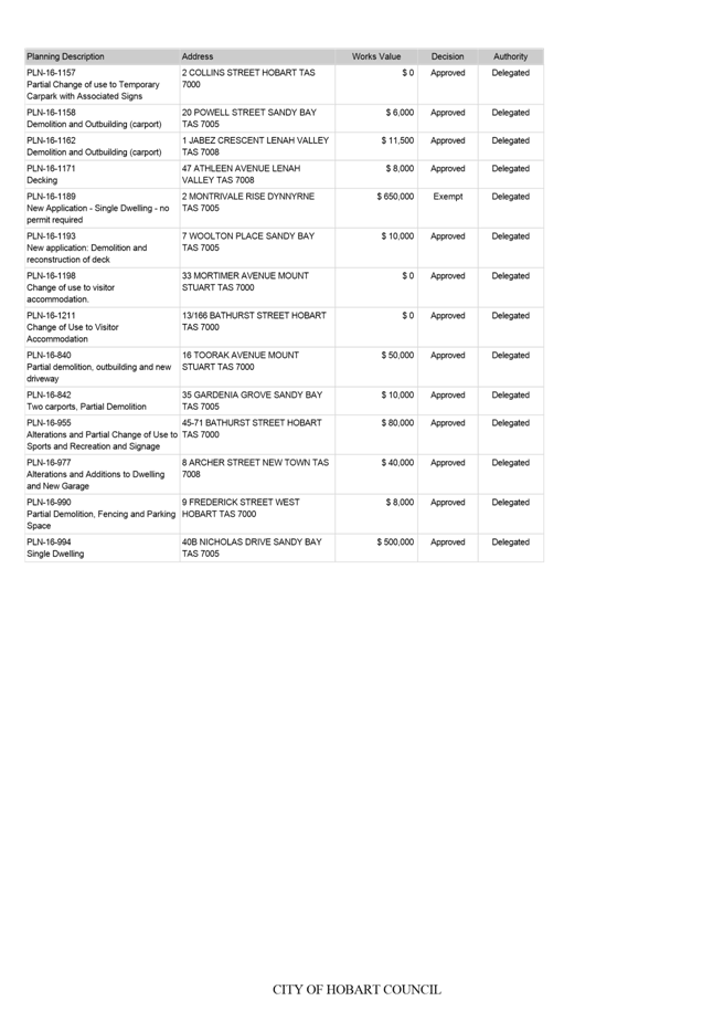
|
|
Agenda (Open Portion) City Planning Committee Meeting |
Page 490 |
|
|
12/12/2016 |
|
Section 29 of the Local Government (Meeting Procedures) Regulations 2015.
File Ref: 13-1-10
An Alderman may ask a question without notice of the Chairman, another Alderman, the General Manager or the General Manager’s representative, in line with the following procedures:
1. The Chairman will refuse to accept a question without notice if it does not relate to the Terms of Reference of the Council committee at which it is asked.
2. In putting a question without notice, an Alderman must not:
(i) offer an argument or opinion; or
(ii) draw any inferences or make any imputations – except so far as may be necessary to explain the question.
3. The Chairman must not permit any debate of a question without notice or its answer.
4. The Chairman, Aldermen, General Manager or General Manager’s representative who is asked a question may decline to answer the question, if in the opinion of the respondent it is considered inappropriate due to its being unclear, insulting or improper.
5. The Chairman may require a question to be put in writing.
6. Where a question without notice is asked and answered at a meeting, both the question and the response will be recorded in the minutes of that meeting.
7. Where a response is not able to be provided at the meeting, the question will be taken on notice and
(i) the minutes of the meeting at which the question is asked will record the question and the fact that it has been taken on notice.
(ii) a written response will be provided to all Aldermen, at the appropriate time.
(iii) upon the answer to the question being circulated to Aldermen, both the question and the answer will be listed on the agenda for the next available ordinary meeting of the committee at which it was asked, where it will be listed for noting purposes only.
|
|
Agenda (Open Portion) City Planning Committee Meeting |
Page 491 |
|
|
12/12/2016 |
|