City
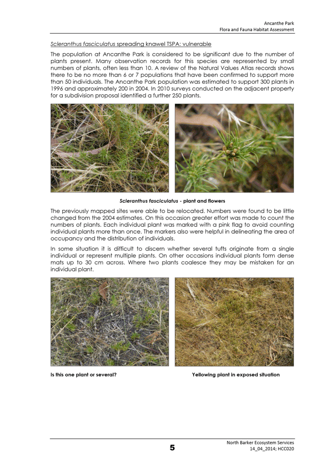
of hobart
AGENDA
City Planning Committee Meeting
Open Portion
Monday, 31 October 2016
at 5.00 pm
Lady Osborne Room, Town Hall
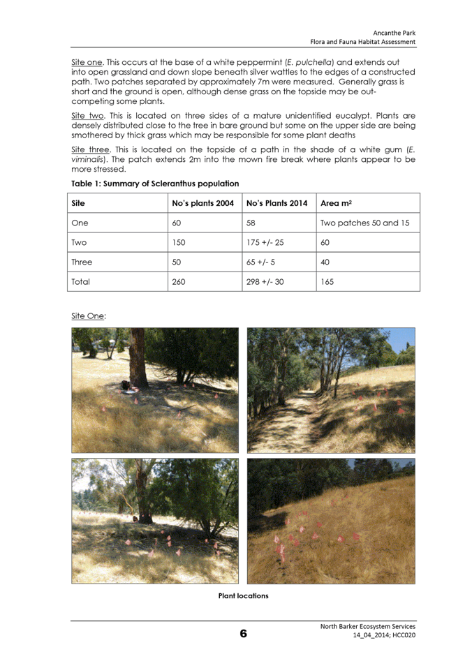
City
of hobart
AGENDA
City Planning Committee Meeting
Open Portion
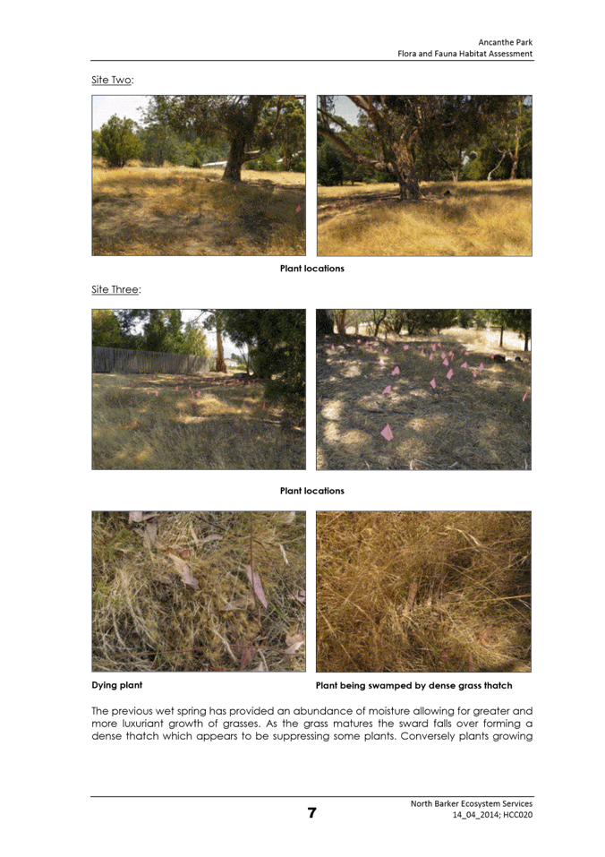
Monday, 31 October 2016
at 5.00 pm
Lady Osborne Room, Town Hall
THE MISSION
Our mission is to ensure good governance of our capital City.
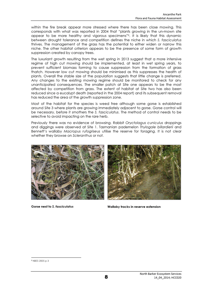
THE VALUES
The Council is:
|
about people |
We value people – our community, our customers and colleagues. |
|
professional |
We take pride in our work. |
|
enterprising |
We look for ways to create value. |
|
responsive |
We’re accessible and focused on service. |
|
inclusive |
We respect diversity in people and ideas. |
|
making a difference |
We recognise that everything we do shapes Hobart’s future. |
|
|
Agenda (Open Portion) City Planning Committee Meeting |
Page 3 |
|
|
31/10/2016 |
|
Business listed on the agenda is to be conducted in the order in which it is set out, unless the committee by simple majority determines otherwise.
APOLOGIES AND LEAVE OF ABSENCE
1. Co-Option of a Committee Member in the event of a vacancy
3. Consideration of Supplementary Items
4. Indications of Pecuniary and Conflicts of Interest.
6. Planning Authority Items - Consideration of Items With Deputations
7. Committee Acting as Planning Authority
7.1 Applications under the Hobart Interim Planning Scheme 2015
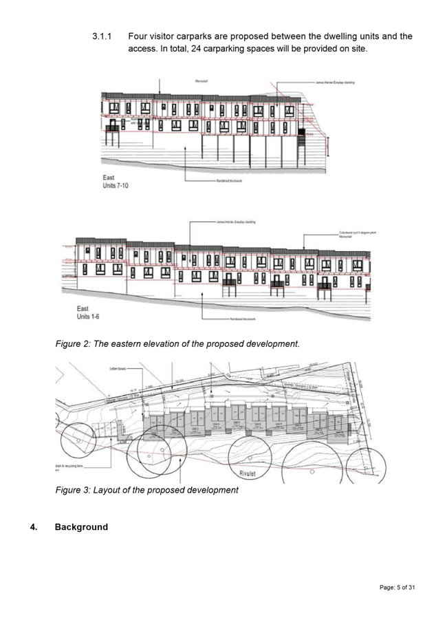
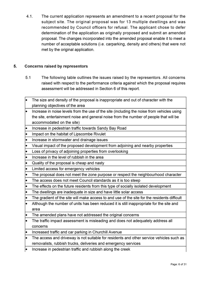
7.1.2 337 Churchill Avenue, Sandy Bay - Demolition and Ten Multiple Dwellings
8.2 City Planning - Advertising List
8.3 Delegated Decisions Report (Planning)
8.4 Applications approved under the Building Regulations 2014 and the Building Act 2000
10. Closed Portion Of The Meeting
|
|
Agenda (Open Portion) City Planning Committee Meeting |
Page 5 |
|
|
31/10/2016 |
|
City Planning Committee Meeting (Open Portion) held Monday, 31 October 2016 at 5.00 pm in the Lady Osborne Room, Town Hall.
|
COMMITTEE MEMBERS Briscoe (Chairman) Ruzicka Burnet Denison
ALDERMEN Lord Mayor Hickey Deputy Lord Mayor Christie Zucco Sexton Cocker Thomas Reynolds Harvey |
Apologies: Nil
Leave of Absence: Alderman Denison
|
|
The minutes of the Open Portion of the City Planning Committee meeting held on Monday, 17 October 2016, are submitted for confirming as an accurate record.
|
Ref: Part 2, Regulation 8(6) of the Local Government (Meeting Procedures) Regulations 2015.
|
That the Committee resolve to deal with any supplementary items not appearing on the agenda, as reported by the General Manager.
|
Ref: Part 2, Regulation 8(7) of the Local Government (Meeting Procedures) Regulations 2015.
Aldermen are requested to indicate where they may have any pecuniary or conflict of interest in respect to any matter appearing on the agenda, or any supplementary item to the agenda, which the committee has resolved to deal with.
Regulation 15 of the Local Government (Meeting Procedures) Regulations 2015.
A committee may close a part of a meeting to the public where a matter to be discussed falls within 15(2) of the above regulations.
In the event that the committee transfer an item to the closed portion, the reasons for doing so should be stated.
Are there any items which should be transferred from this agenda to the closed portion of the agenda, or from the closed to the open portion of the agenda?
In accordance with the requirements of Part 2 Regulation 8(3) of the Local Government (Meeting Procedures) Regulations 2015, the General Manager is to arrange the agenda so that the planning authority items are sequential.
In accordance with Part 2 Regulation 8(4) of the Local Government (Meeting Procedures) Regulations 2015, the Committee by simple majority may change the order of any of the items listed on the agenda, but in the case of planning items they must still be considered sequentially – in other words they still have to be dealt with as a single group on the agenda.
Where deputations are to be received in respect to planning items, past practice has been to move consideration of these items to the beginning of the meeting.
RECOMMENDATION
That in accordance with Regulation 8(4) of the Local Government (Meeting Procedures) Regulations 2015, the Committee resolve to deal with any items which have deputations by members of the public regarding any planning matter listed on the agenda, to be taken out of sequence in order to deal with deputations at the beginning of the meeting.
|
|
Agenda (Open Portion) City Planning Committee Meeting |
Page 6 |
|
|
31/10/2016 |
|
In accordance with the provisions of Part 2 Regulation 25 of the Local Government (Meeting Procedures) Regulations 2015, the intention of the Committee to act as a planning authority pursuant to the Land Use Planning and Approvals Act 1993 is to be noted.
In accordance with Regulation 25, the Committee will act as a planning authority in respect to those matters appearing under this heading on the agenda, inclusive of any supplementary items.
The Committee is reminded that in order to comply with Regulation 25(2), the General Manager is to ensure that the reasons for a decision by a Council or Council Committee acting as a planning authority are recorded in the minutes.
|
Agenda (Open Portion) City Planning Committee Meeting |
Page 7 |
|
|
|
31/10/2016 |
|
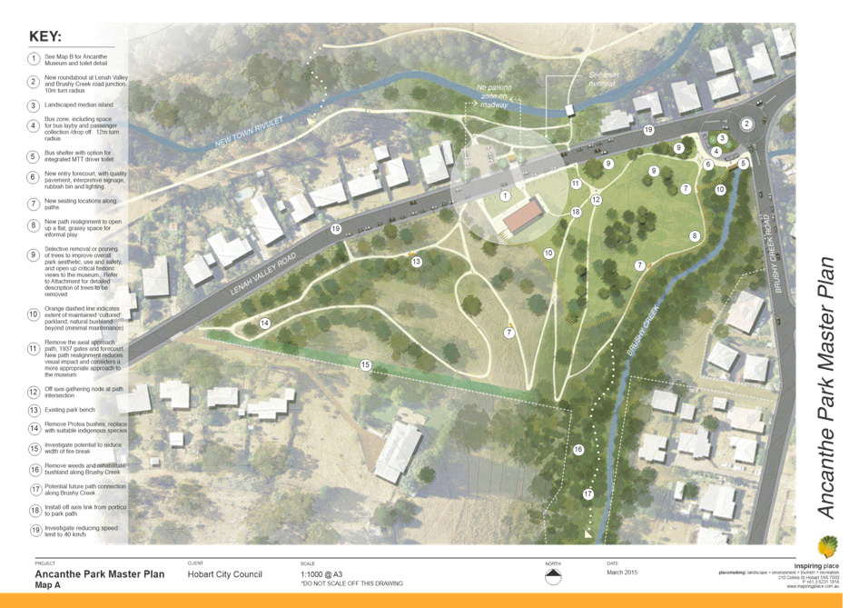
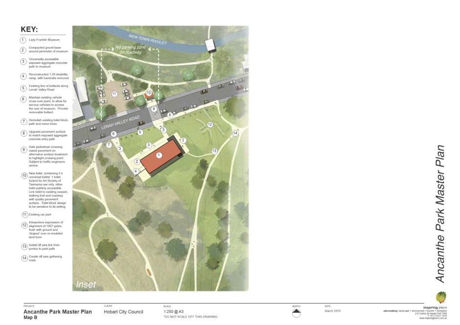
7.1 Applications under the Hobart Interim Planning Scheme 2015
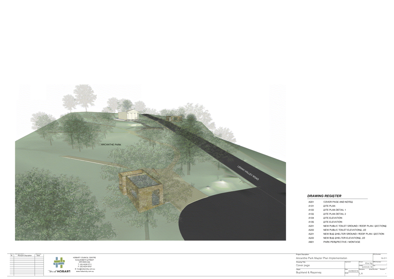
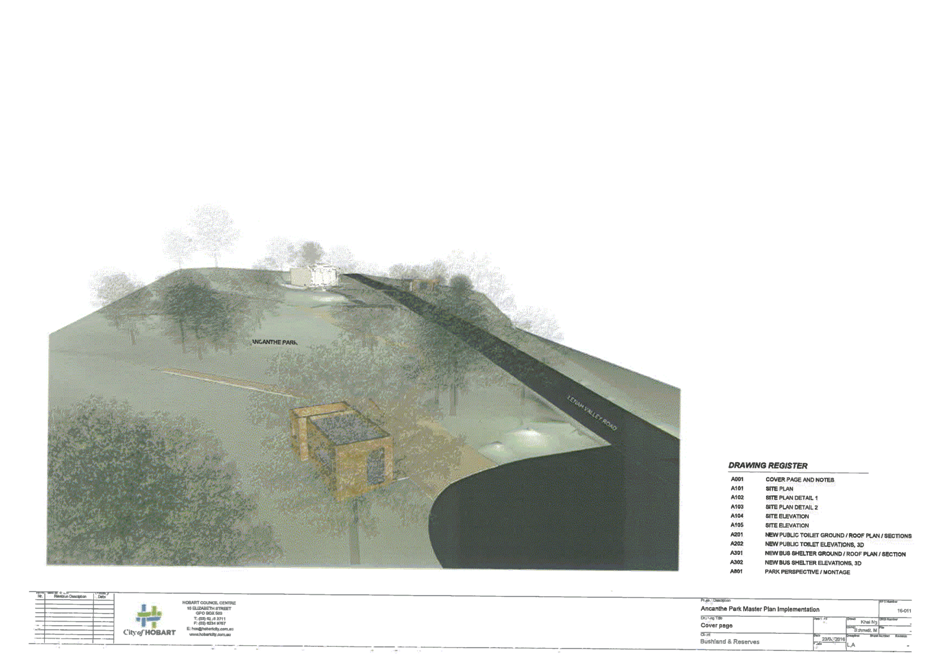
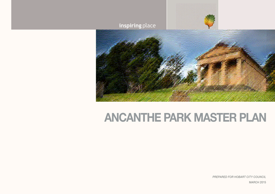
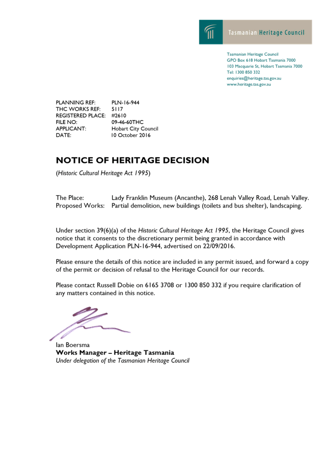
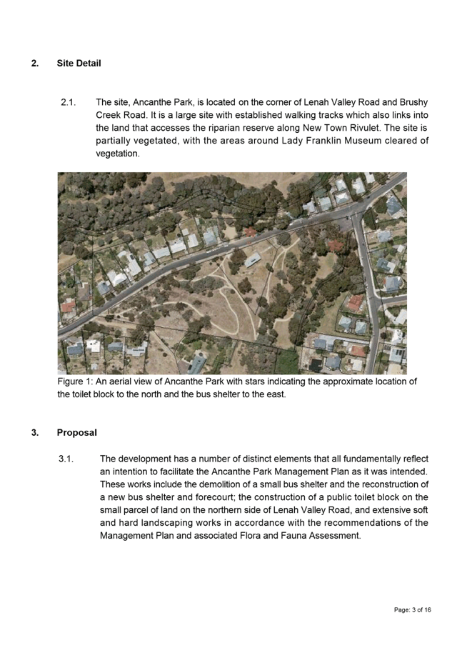
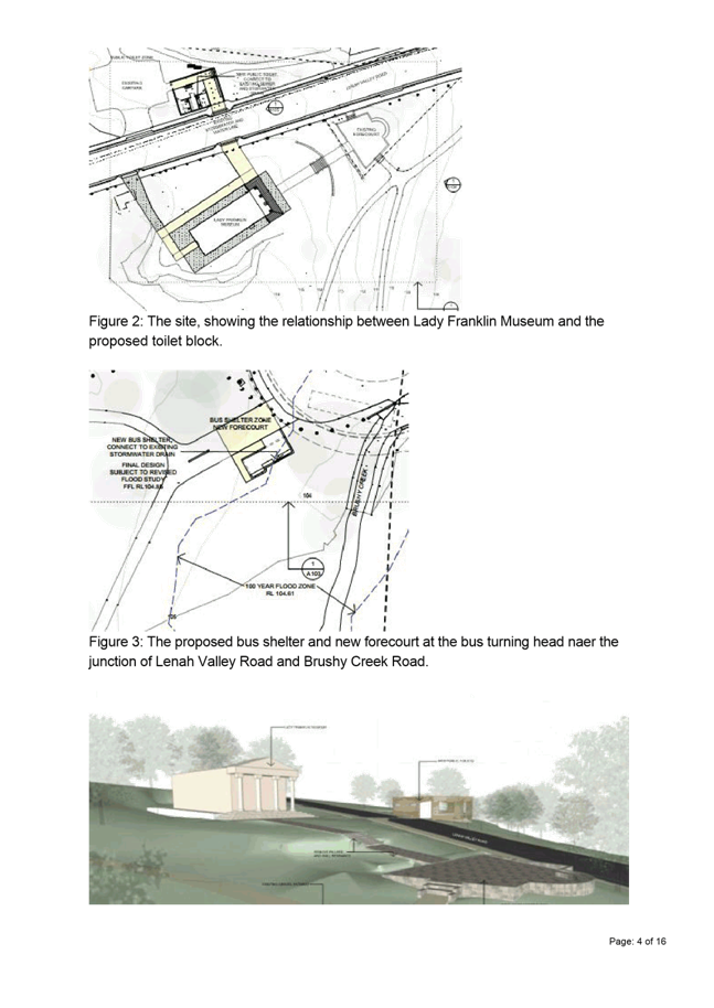
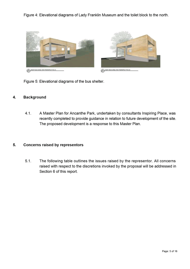
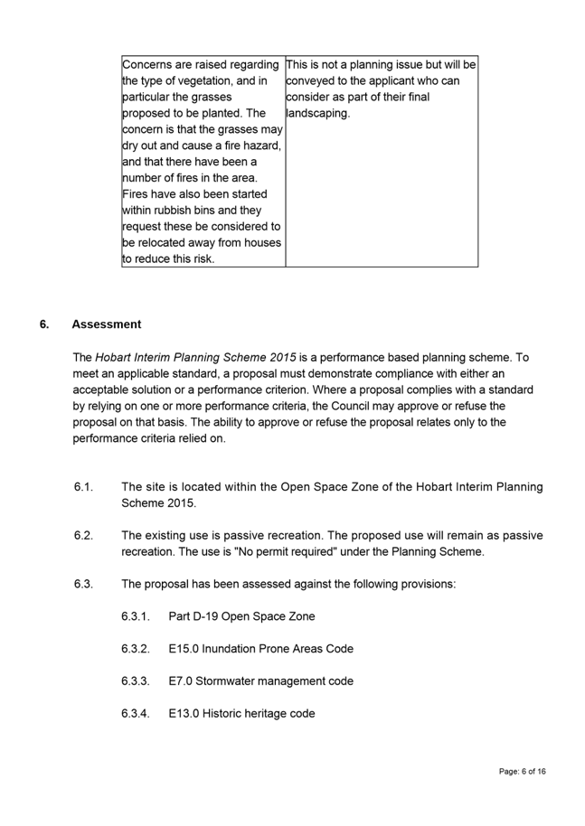
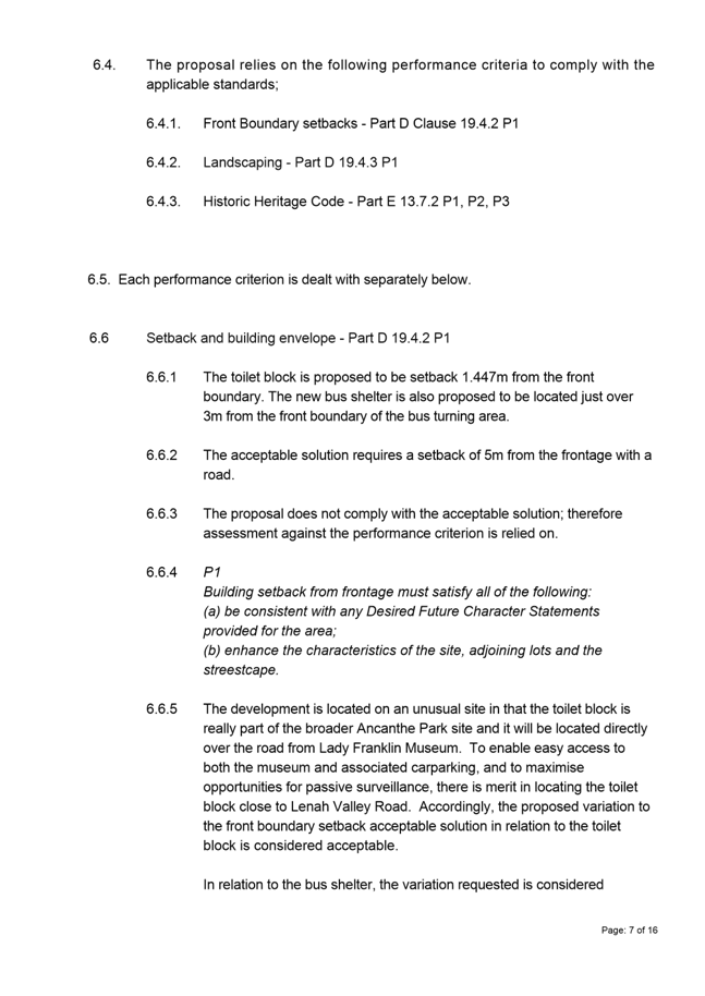
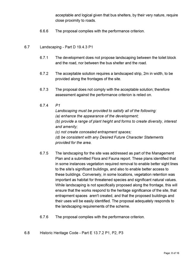
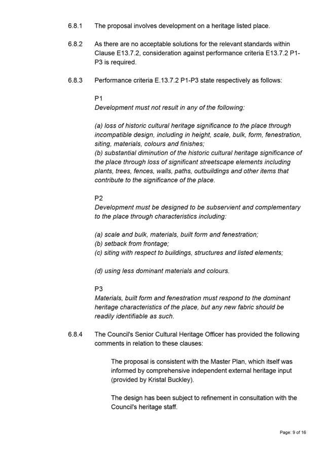
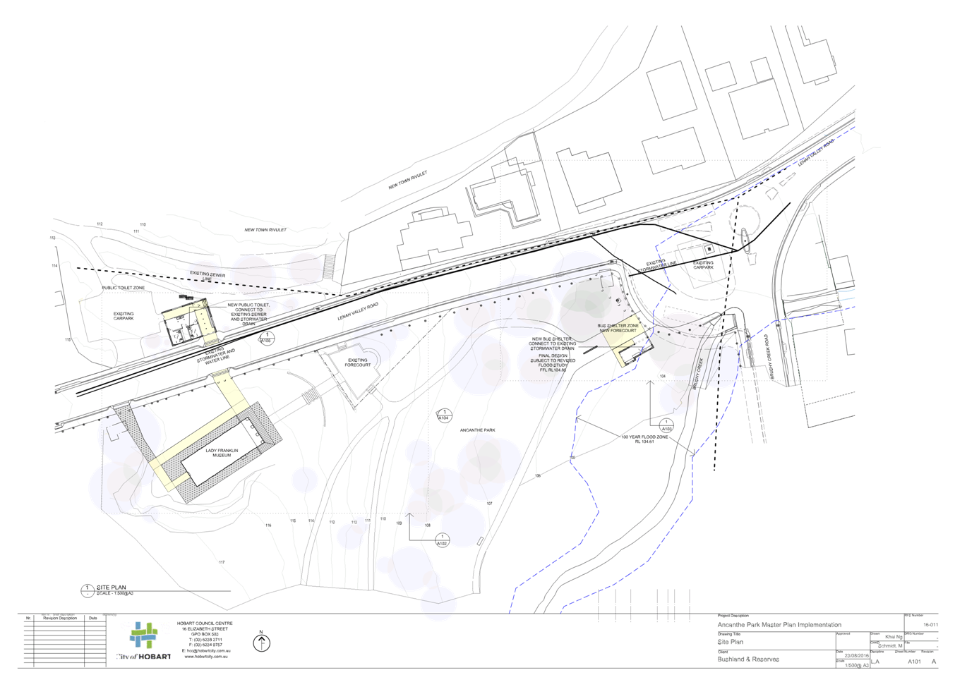
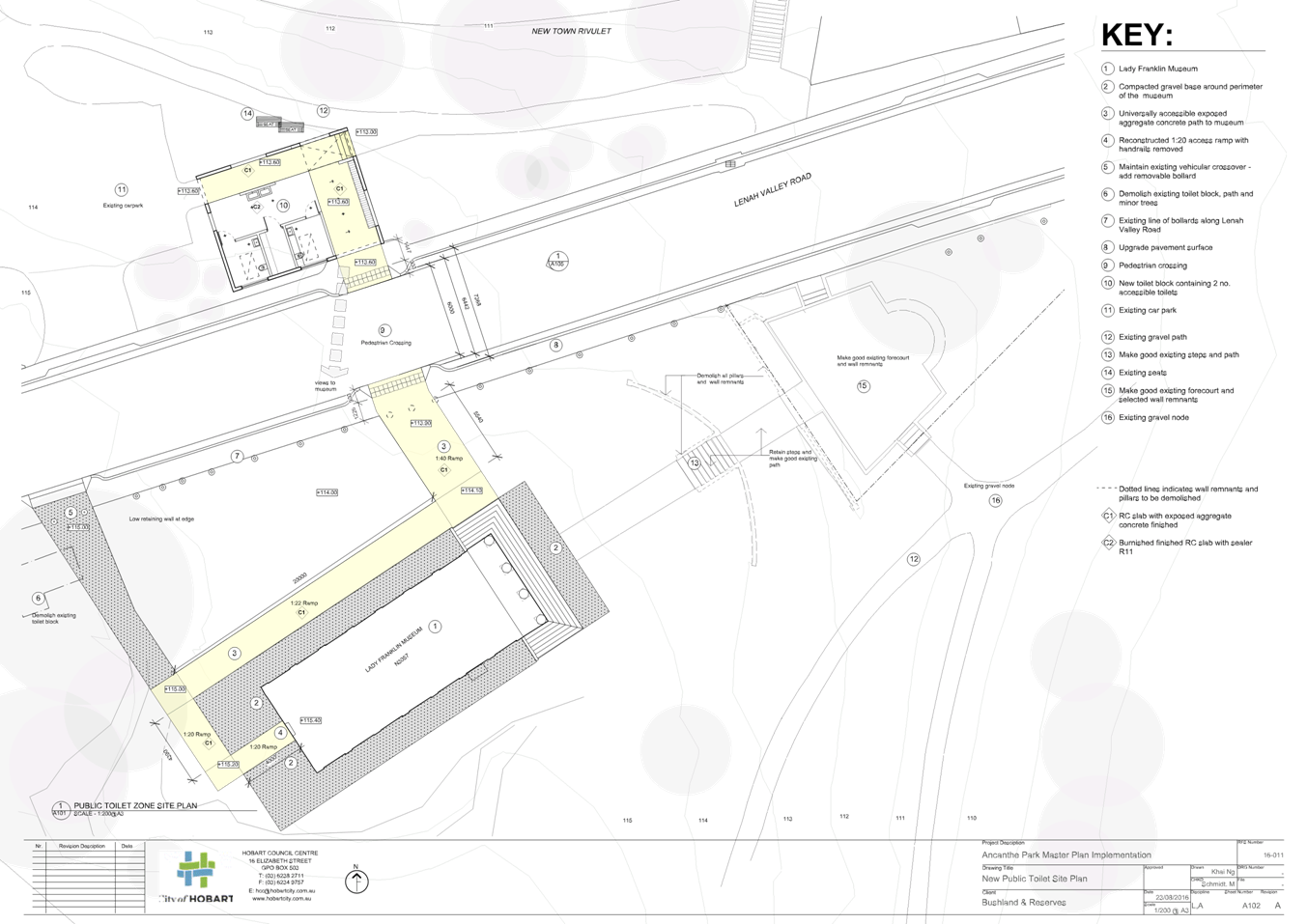
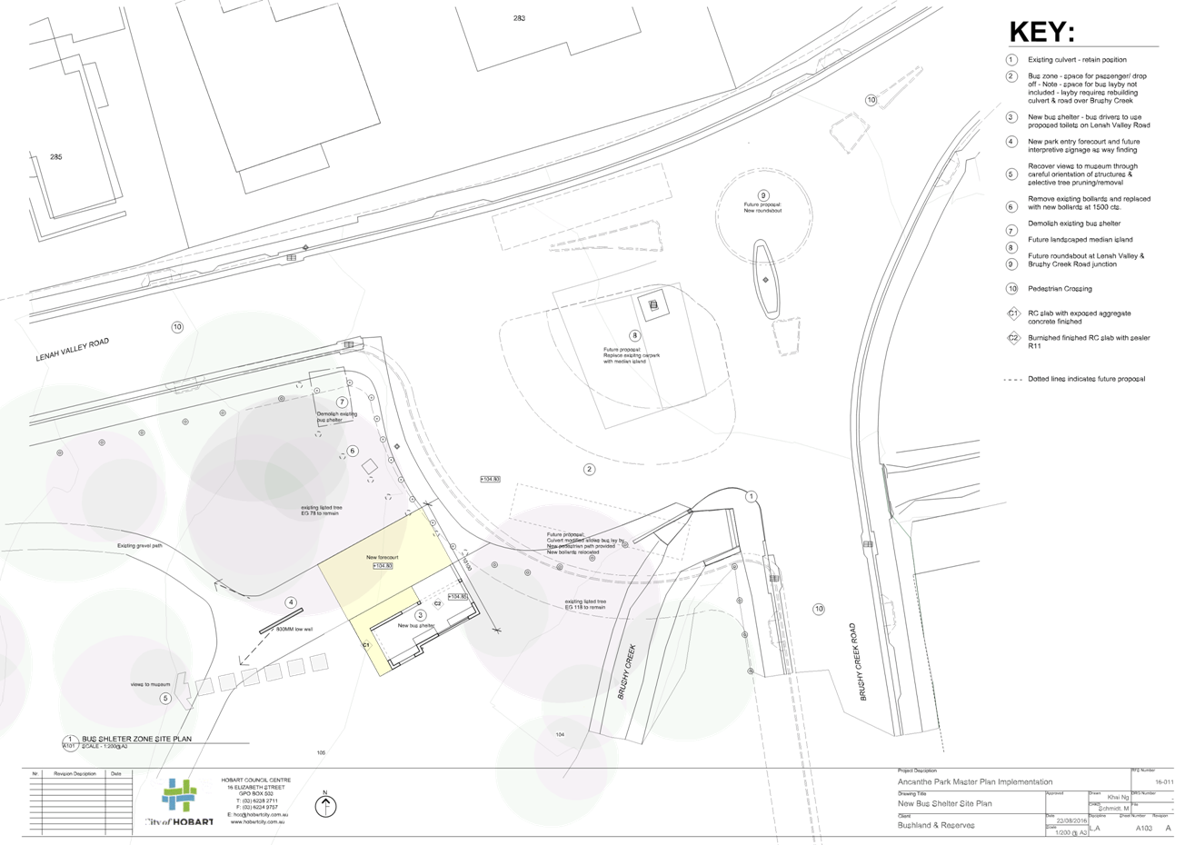
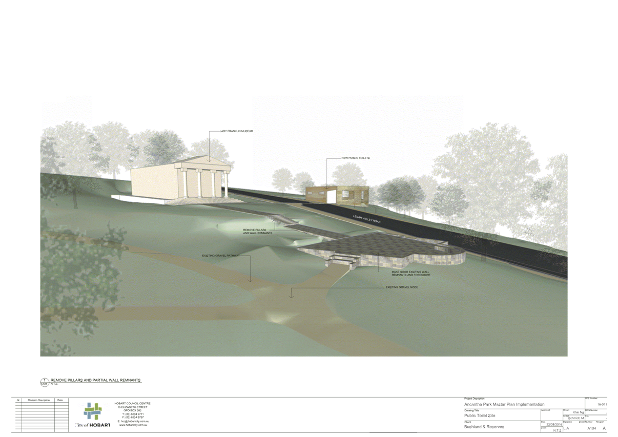
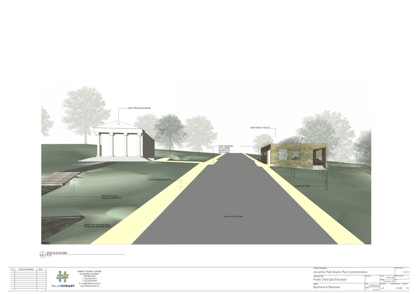
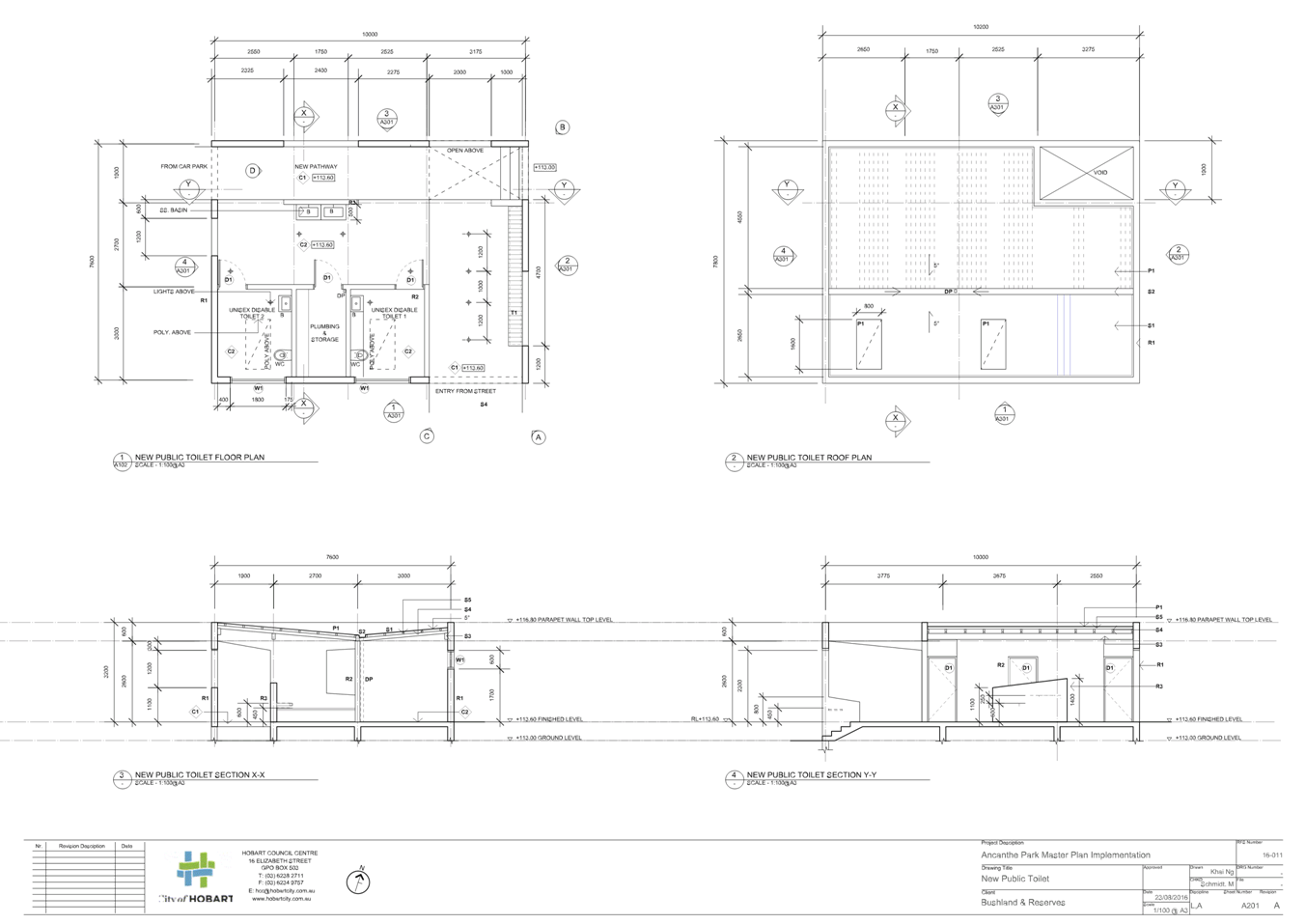
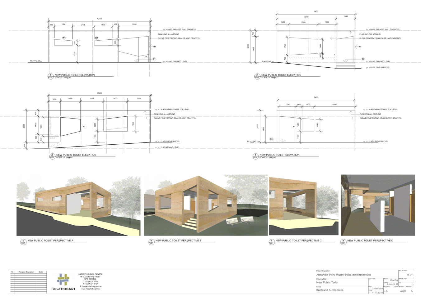
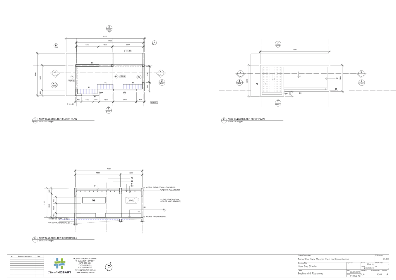
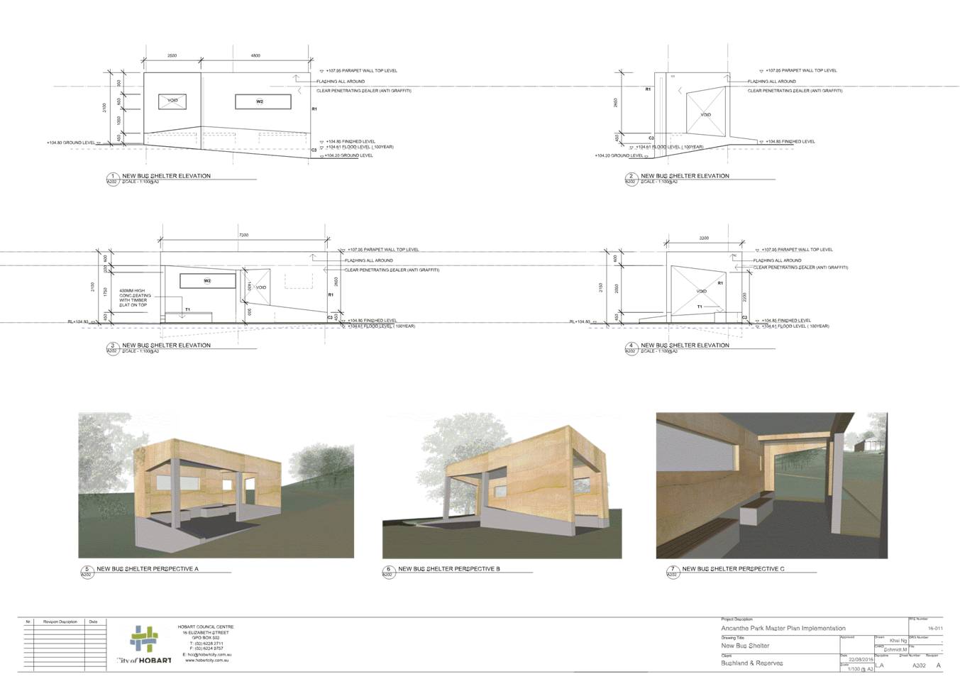
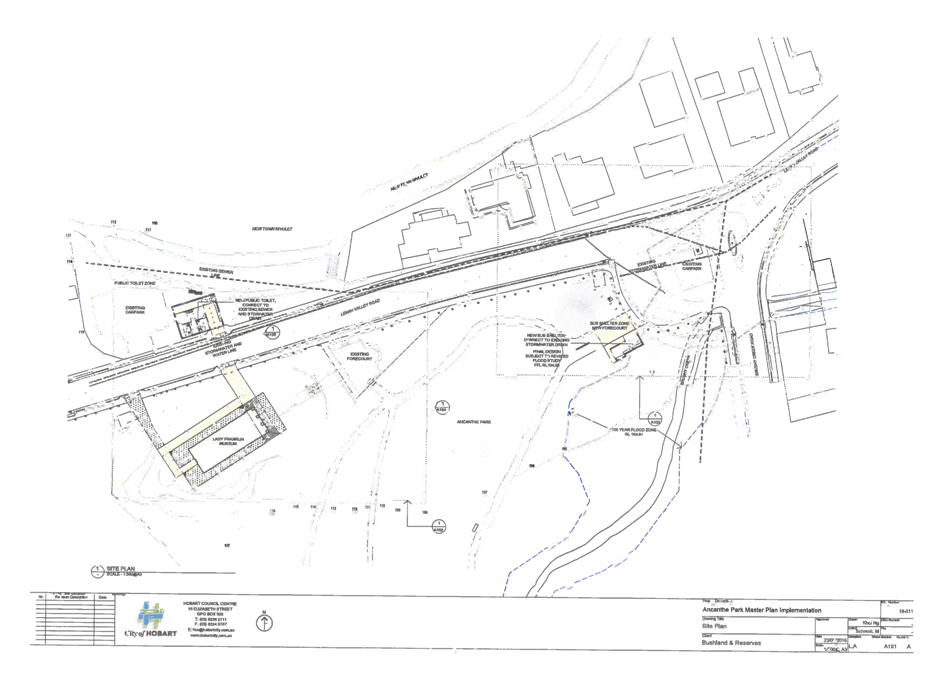
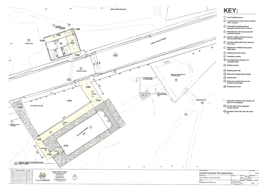
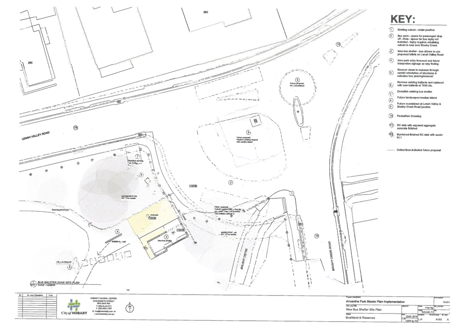
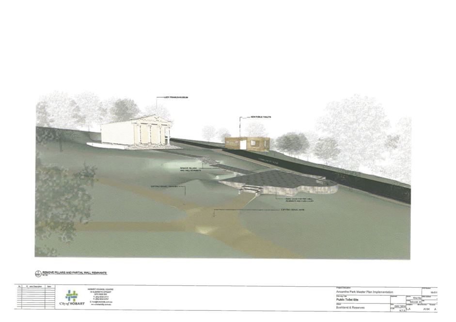
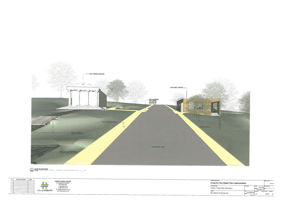
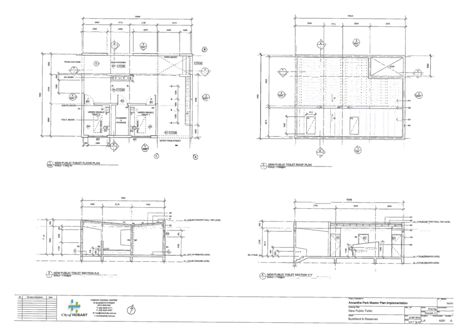
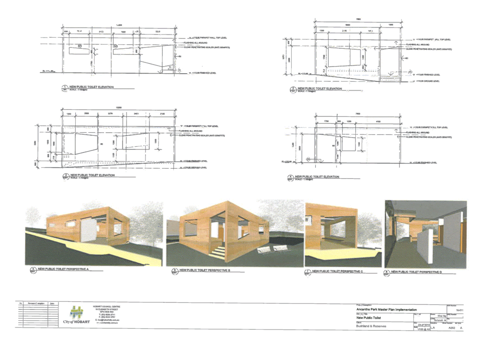
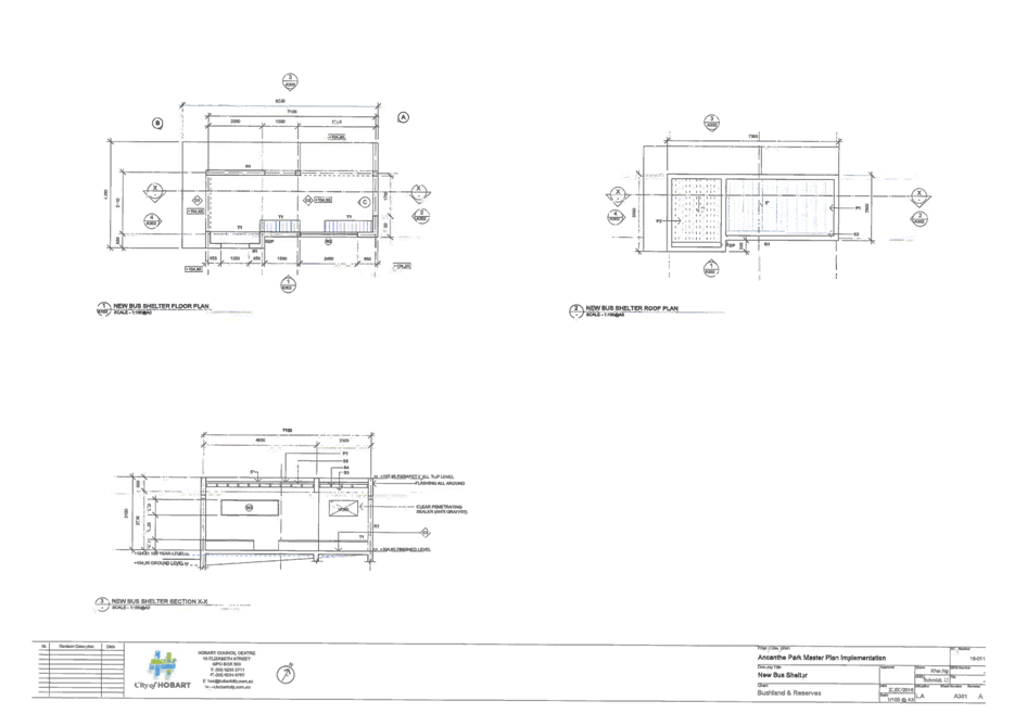
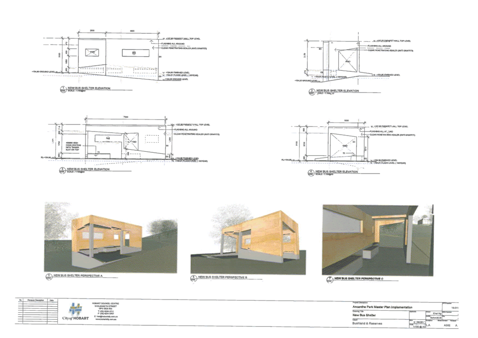
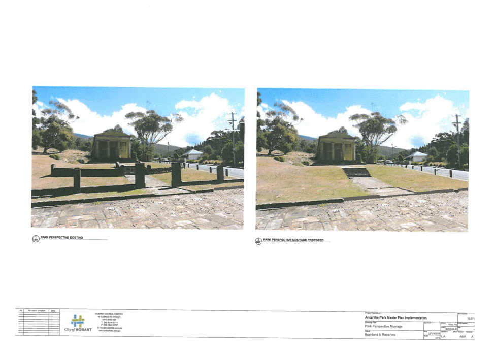
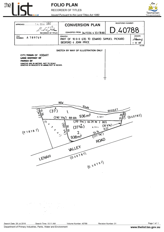
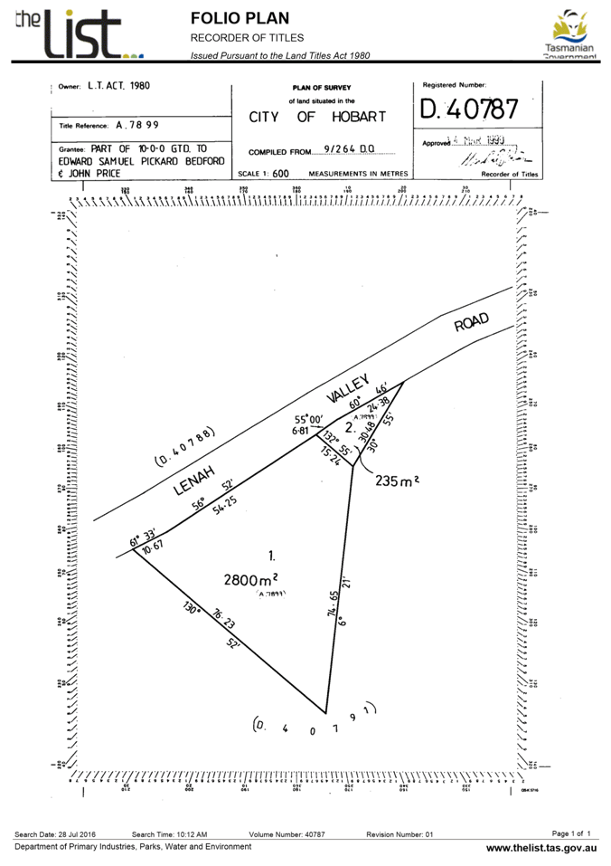
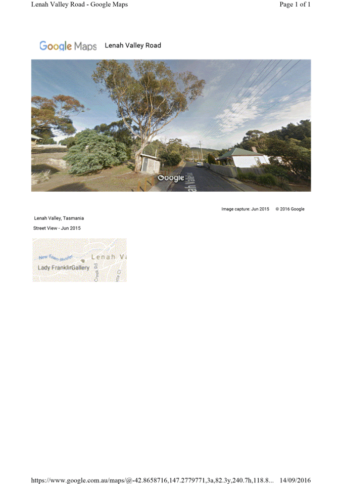
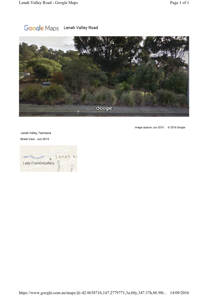
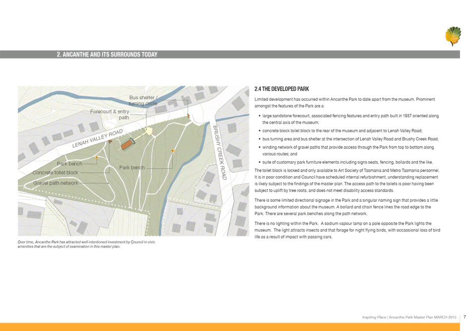
7.1.1 268 Lenah Valley Road, 269 Lenah Valley Road, Lenah Valley - Partial Demolition, New Buildings (Public Toilets and Bus Shelter) and Landscaping
PLN-16-944 - FILE REF: F16/122221
Address: 268 Lenah Valley Road, 269 Lenah Valley Road, Lenah Valley
Proposal: Partial Demolition, New Buildings (Public Toilets and Bus Shelter) and Landscaping
Expiry Date: 14 November 2016
Extension of Time: Not applicable
Author: Caroline Lindus
|
REcommendation That pursuant to the Hobart Interim Planning Scheme 2015, the Council approve the application for partial demolition, new buildings (public toilets and bus shelter) and landscaping at 268 and 269 Lenah Valley Road, Lenah Valley for the reasons outlined in the officer’s report and a permit containing the following conditions be issued:
GEN
The use and/or development must be substantially in accordance with the documents and drawings that comprise PLN16944 268 Lenah Valley Road, 269 Lenah Valley Road Final Planning Documents except where modified below.
Reason for condition
To clarify the scope of the permit.
THC
The use and/or development must comply with the requirements of the Tasmanian Heritage Council as detailed in the Notice of Heritage Decision, Works Application No. 5117 dated 10 October 2016 as attached to the permit.
Reason for condition
To clarify the scope of the permit.
ENG sw4
The new storm water connection must be constructed and existing abandoned connections sealed by Council at the owner’s expense, prior to the first occupation.
Detailed
engineering drawings must
be submitted and
approved, prior to commencement of work. The detailed
engineering drawings must include: 1. the location of the proposed connection; and 2. the size of the connection appropriate to satisfy the needs of the development.
All work required by this condition must be undertaken in accordance with the approved engineering drawings.
Advice: Once the engineered drawing has been approved the Council will issue a condition endorsement (see general advice on how to obtain condition endorsement).
Please note that once the condition endorsement has been issued you will need to contact Council’s City Infrastructure Unit to initiate an application for service connection.
Reason for condition
To ensure the site is drained adequately.
ENG 1
The cost of repair of any damage to the Council infrastructure resulting from the implementation of this permit, must be met by the owners within 30 days of the completion of the development or as otherwise determined by the Council.
A photographic record of the Council infrastructure adjacent to the subject site must be provided to the Council prior to any commencement of works.
A photographic record of the Council’s infrastructure (e.g. existing property service connection points, roads, buildings, stormwater, footpaths, driveway crossovers and nature strips, including if any, pre existing damage) will be relied upon to establish the extent of damage caused to the Council’s infrastructure during construction. In the event that the owner/developer fails to provide to the Council a photographic record of the Council’s infrastructure, then any damage to the Council infrastructure found on completion of works will be deemed to be the responsibility of the owner.
Reason for condition
To ensure that any of the Council infrastructure and/or siterelated service connections affected by the proposal will be altered and/or reinstated at the owner’s full cost.
ENG s3
The bus shelter is to be designed and constructed to resist all likely forces and erosion associated with a flood event.
Detailed design drawings of the bus shelter must be submitted and approved prior to the issue of consent under Building Act for the relevant stage. The design drawings must include certification from an accredited and qualified structural engineer that all proposed structures within the flood zone are designed to resist erosion, undermining and likely forces from a flood event.
All work required by this condition must be undertaken in accordance with the approved plans.
Upon completion, certification from a suitably qualified and accredited engineer that the installation has been constructed in accordance with the approved certified design must be provided to Hobart City Council.
Reason for condition
To ensure that the risks associated with inundation are adequately managed.
ENV 2
Sediment and erosion control measures, in accordance with an approved soil and water management plan (SWMP), must be installed prior to the commencement of work and maintained until such time as all disturbed areas have been stabilised and/or restored or sealed to the Council’s satisfaction.
A soil and water management plan (SWMP) must be submitted and approved, prior to the commencement of work. The SWMP must:
a. be prepared in accordance with the Soil and Water Management on Building and Construction Sites fact sheets (Derwent Estuary Program, 2008). http://www.hobartcity.com.au/Development/Engineering_Standards_and_Gui deline. All work required by this condition must be undertaken in accordance with the approved soil and water management plan (SWMP).
Advice: Once the soil and water management plan (SWMP) has been approved the Council will issue a condition endorsement (see general advice on how to obtain condition endorsement).
Reason for condition
To avoid the pollution and sedimentation of roads, drains and natural watercourses that could be caused by erosion and runoff from the development.
ADVICE
The following advice is provided to you to assist in the implementation of the planning permit that has been issued subject to the conditions above. The advice is not exhaustive and you must inform yourself of any other legislation, bylaws, regulations, codes or standards that will apply to your development under which you may need to obtain an approval. Visit www.hobartcity.com.au for further information.
Prior to any commencement of work on the site or commencement of use the following additional permits/approval may be required from the Hobart City Council.
CONDITION ENDORSEMENT
If a condition endorsement is required by a planning condition above, you will need to submit the relevant documentation to satisfy the condition, via the Condition Endorsement Submission on Council's online eservice portal.
Once approved, the Council will respond to you via email that the condition(s) has been endorsed (satisfied). Detailed instructions can be found at: http://www.hobartcity.com.au/Development/Planning/How_to_obtain_a_condition_e ndorsement
BUILDING PERMIT
Building permit
in accordance with the Building Act 2000;
http://www.hobartcity.com.au/Development/Building
Plumbing permit under the Tasmanian Plumbing Regulations 2014; http://www.hobartcity.com.au/Development/Plumbing OCCUPATION OF THE PUBLIC HIGHWAY Permit for the occupation of the public highway for construction or special event (e.g. placement of skip bin, crane, scissor lift etc)
http://www.hobartcity.com.au/Transport/Permits/Construction_Activities_Special_Even ts_in_the_Road_Reservation
Road closure permits for construction or special event.
http://www.hobartcity.com.au/Transport/Permits/Application_Forms__Construction_Activities_Special_Events_in_the_Road_Reservation
Permit to Open Up and Temporarily Occupy a Highway (for work in the road reserve)
STORMWATER
Please note that in addition to a building and/or plumbing permit, development must be in accordance with the Hobart City Council’s Hydraulic Services By law.
http://www.hobartcity.com.au/Council/Legislation
FEES AND CHARGES http://www.hobartcity.com.au/Council/Fees_and_Charges
If you do not have access to the Council’s electronic web page, please phone the Council (City Planning) on 62382715 for assistance.
|
Attachment a: PLN-16-944
- 269 LENAH VALLEY ROAD LENAH VALLEY TAS 7008 - Planning Committee or Delegated
Report ⇩ ![]()
Attachment
b: PLN-16-944
- 269 LENAH VALLEY ROAD LENAH VALLEY TAS 7008 - CPC Agenda Documents_ ⇩ ![]()
|
Item No. 7.1.1 |
Agenda (Open Portion) City Planning Committee Meeting - 31/10/2016 |
Page 13 ATTACHMENT a |


|
Agenda (Open Portion) City Planning Committee Meeting - 31/10/2016 |
Page 29 ATTACHMENT b |
|
Item No. 7.1.1 |
Agenda (Open Portion) City Planning Committee Meeting - 31/10/2016 |
Page 41 ATTACHMENT b |


|
Item No. 7.1.1 |
Agenda (Open Portion) City Planning Committee Meeting - 31/10/2016 |
Page 71 ATTACHMENT b |
|
Item No. 7.1.1 |
Agenda (Open Portion) City Planning Committee Meeting - 31/10/2016 |
Page 83 ATTACHMENT b |

|
Item No. 7.1.1 |
Agenda (Open Portion) City Planning Committee Meeting - 31/10/2016 |
Page 94 ATTACHMENT b |


|
Item No. 7.1.1 |
Agenda (Open Portion) City Planning Committee Meeting - 31/10/2016 |
Page 135 ATTACHMENT b |
|
Item No. 7.1.2 |
Agenda (Open Portion) City Planning Committee Meeting |
Page 136 |
|
|
31/10/2016 |
|
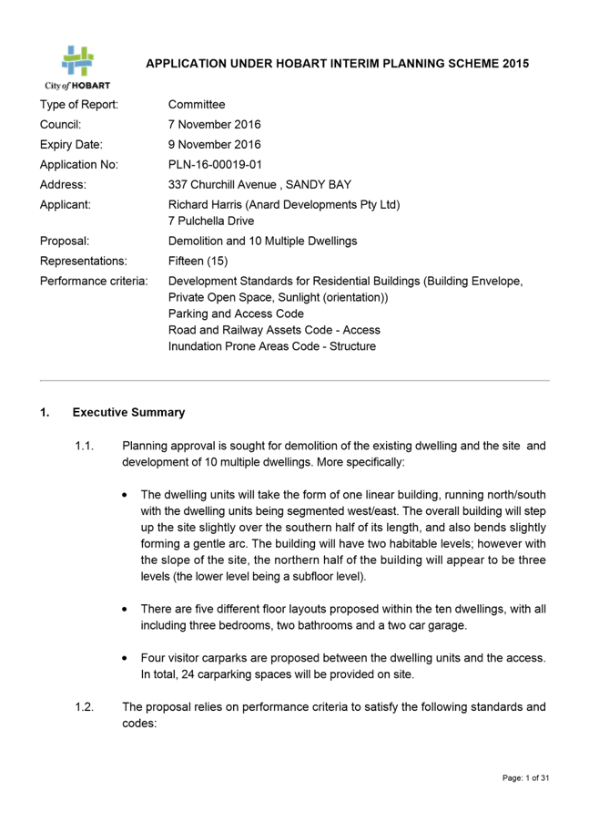
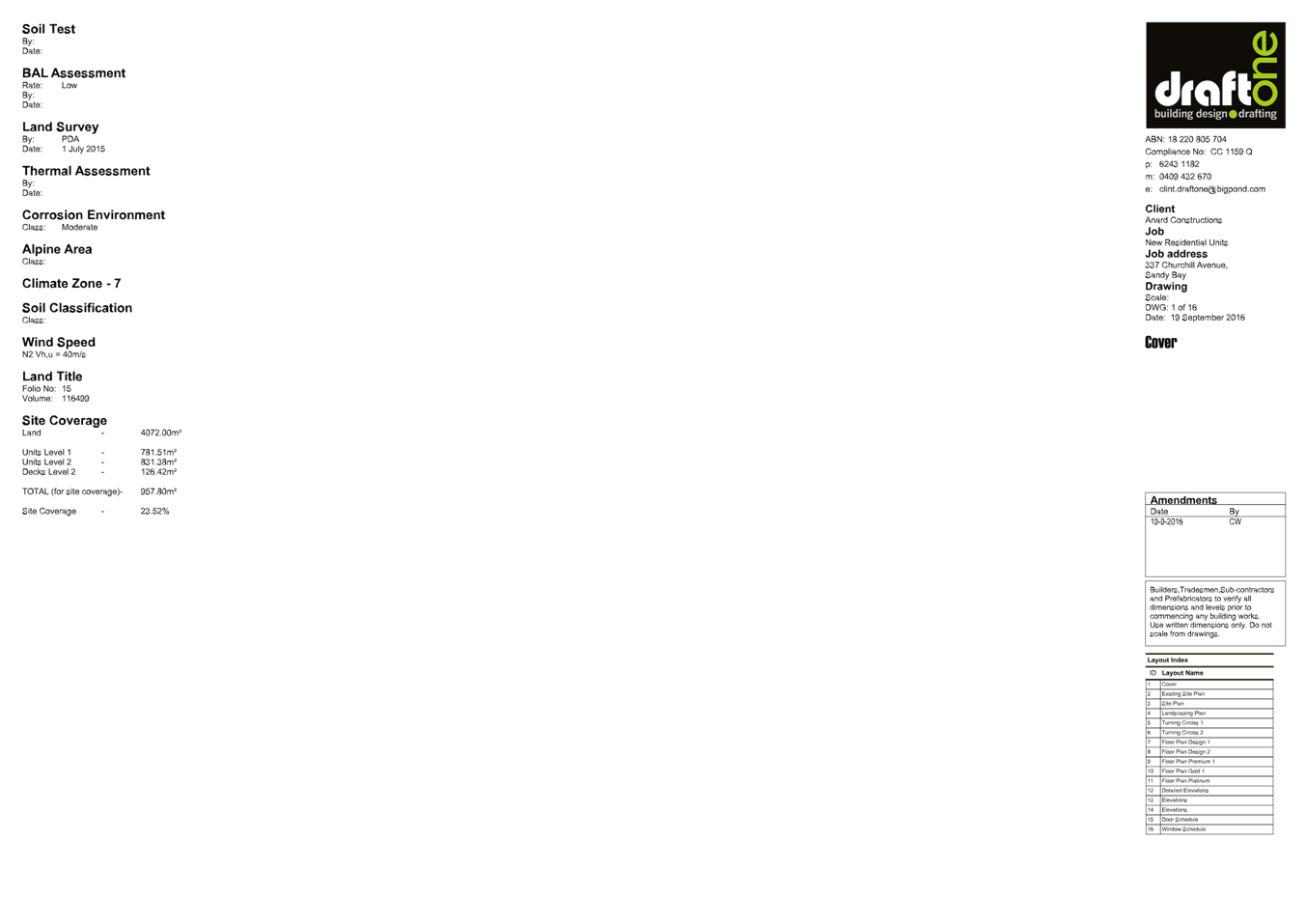
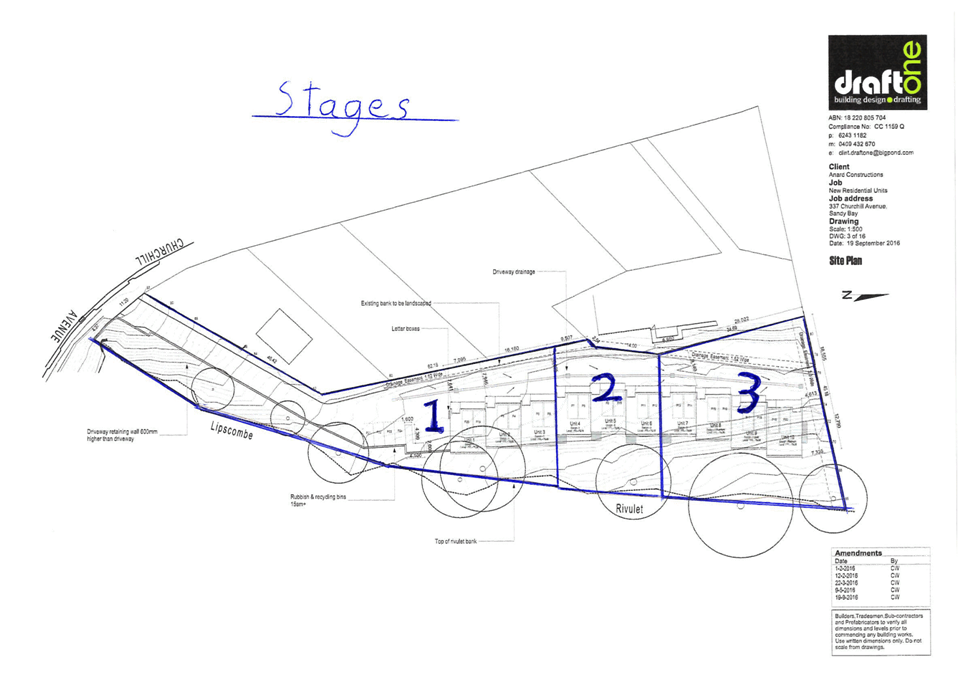
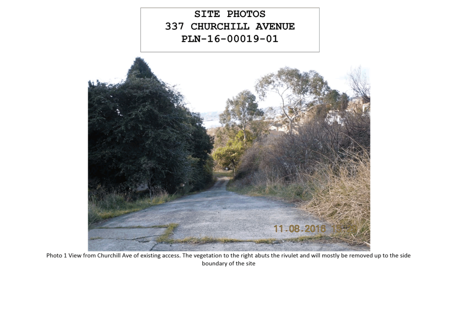
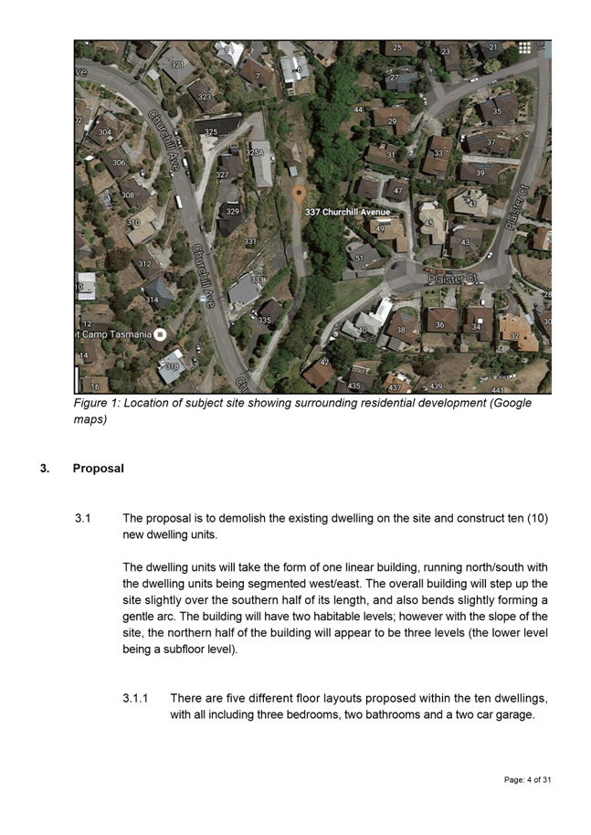
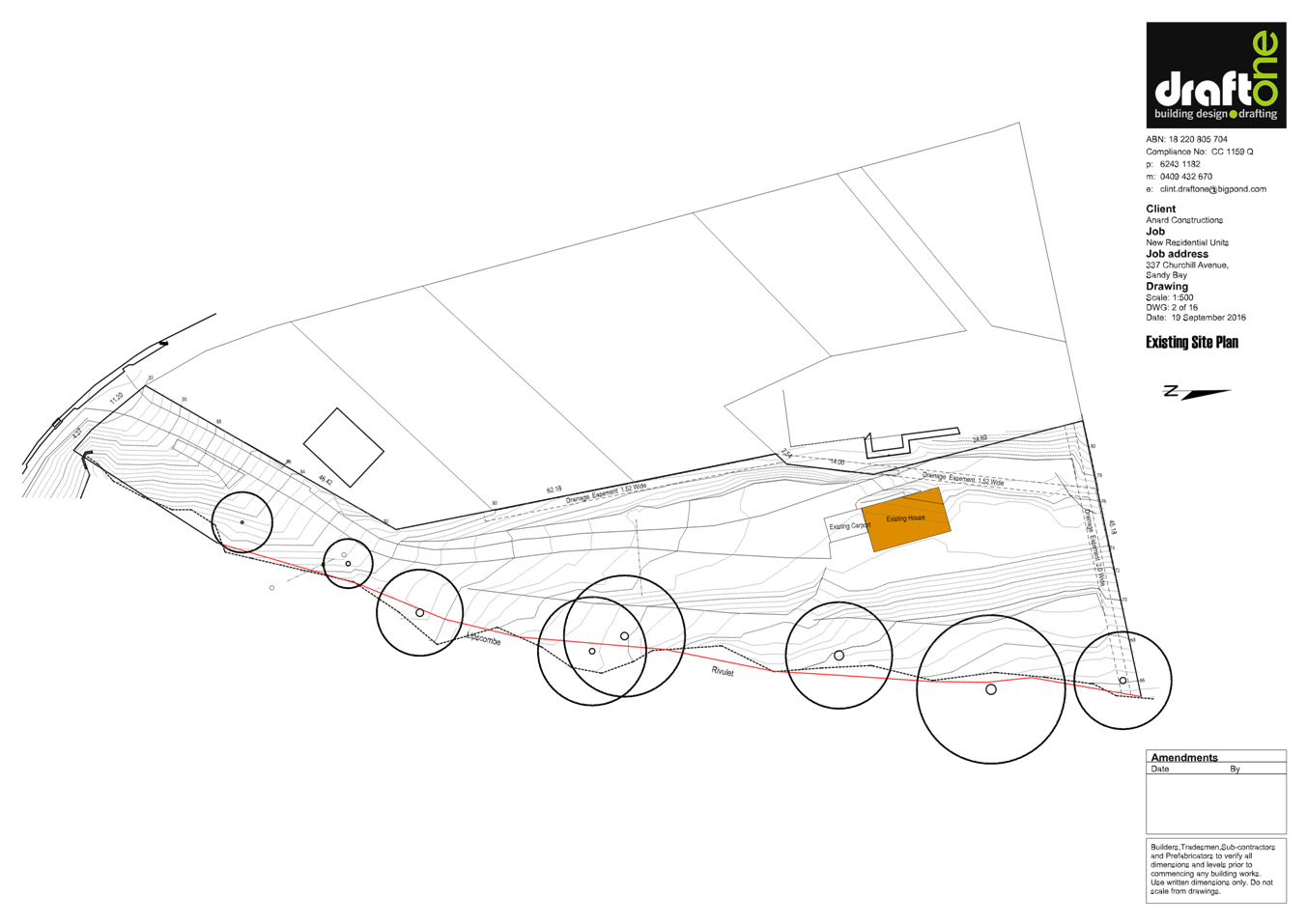
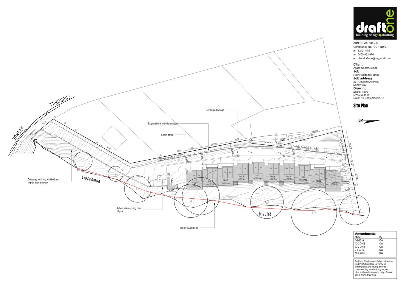
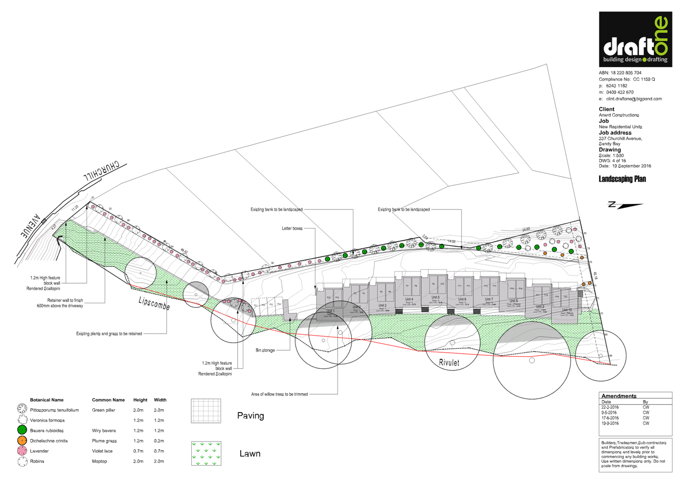
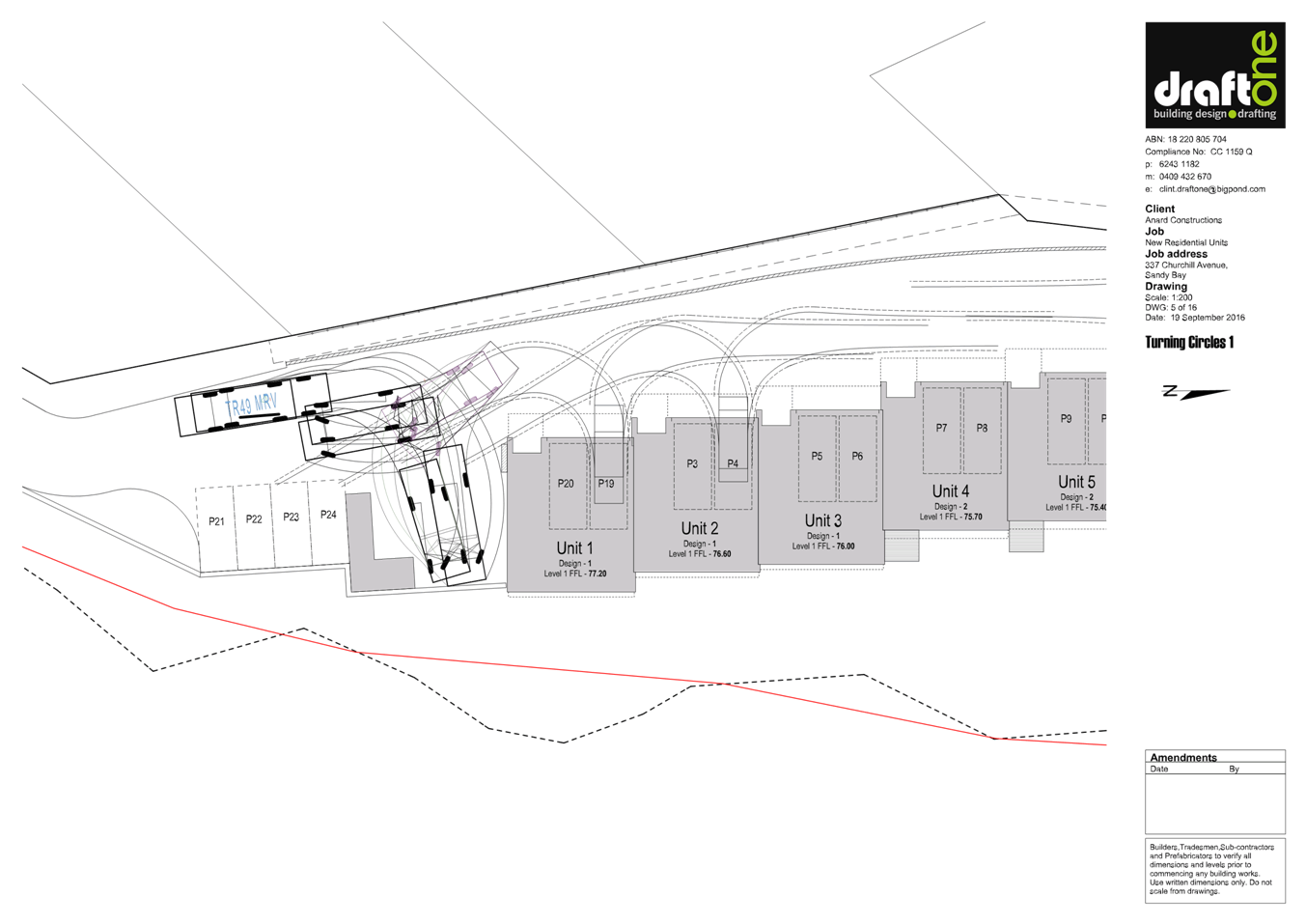
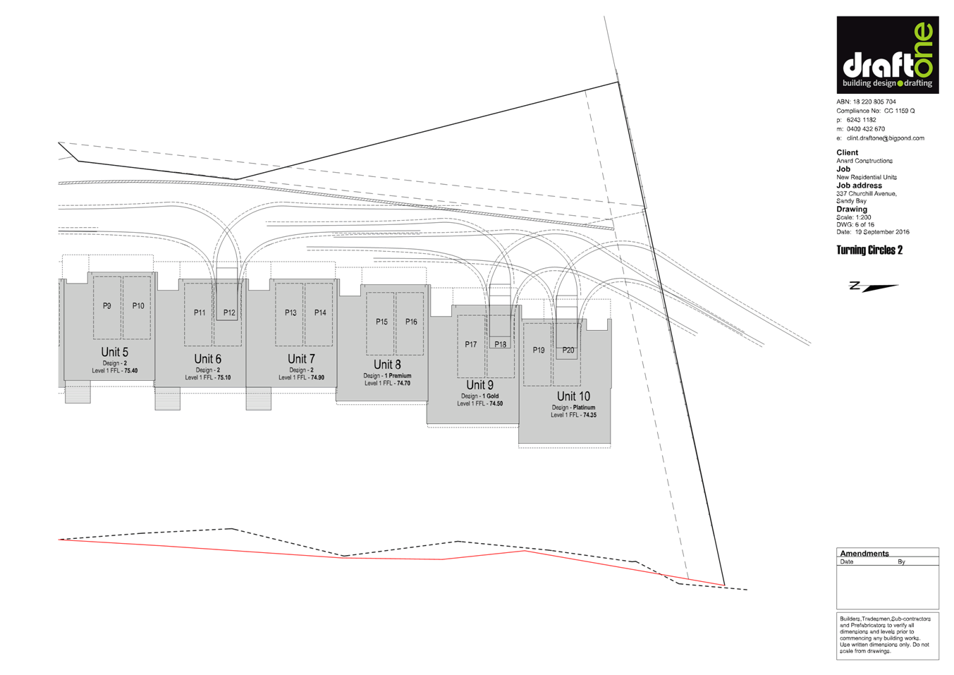
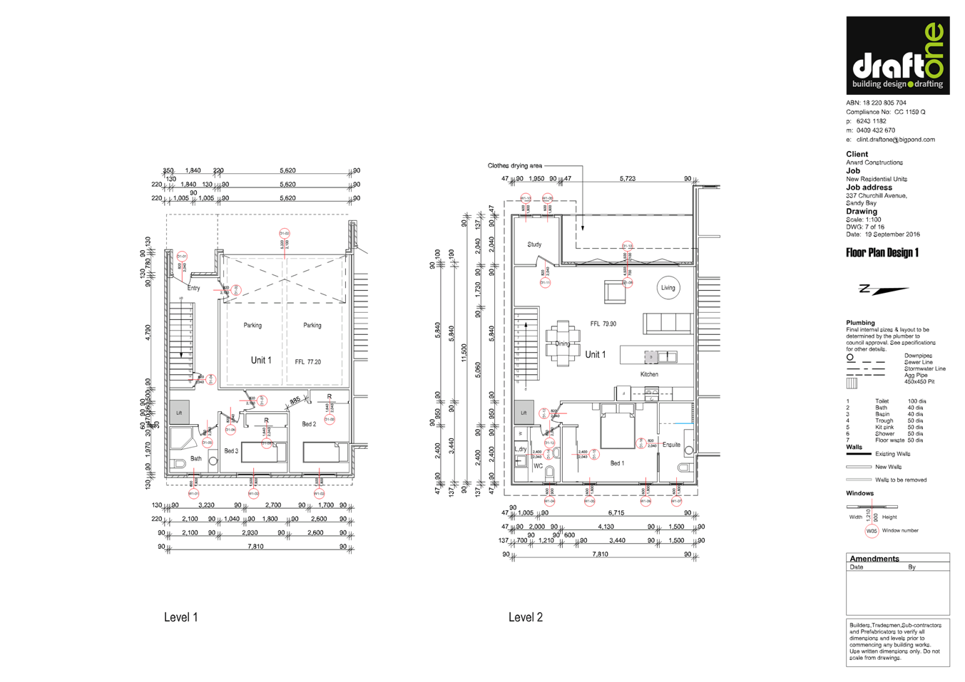
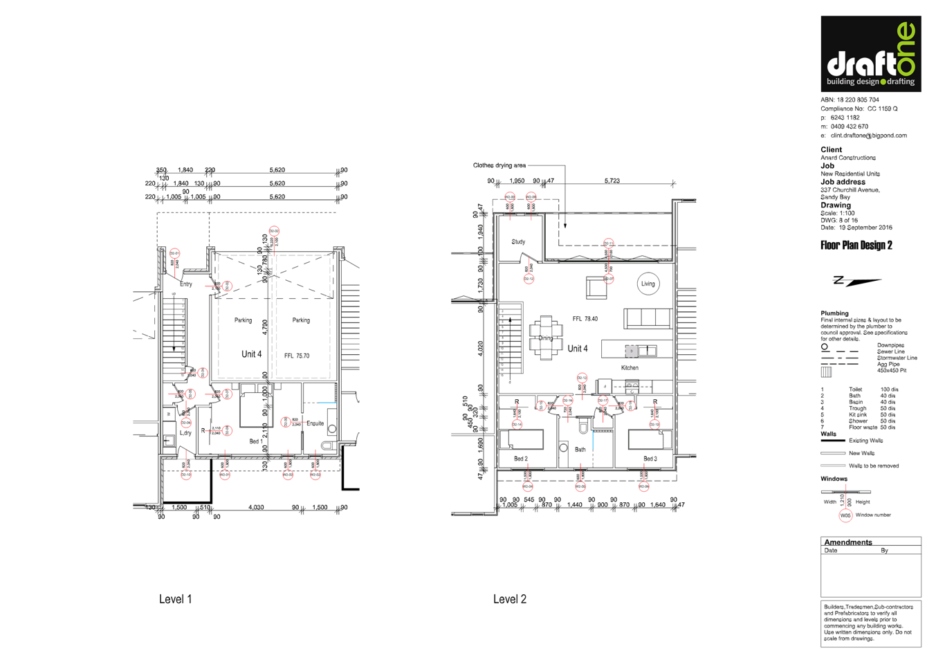
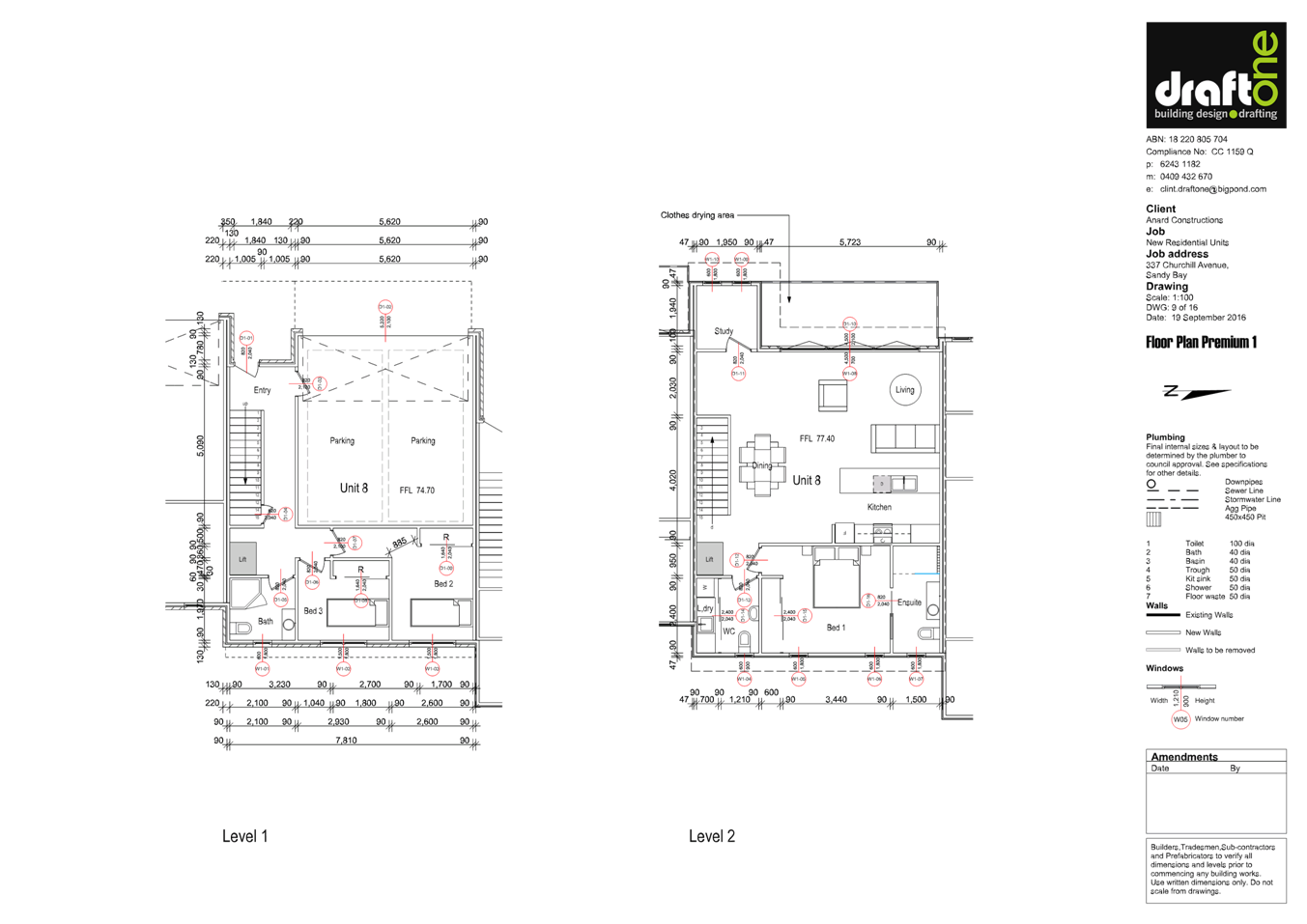
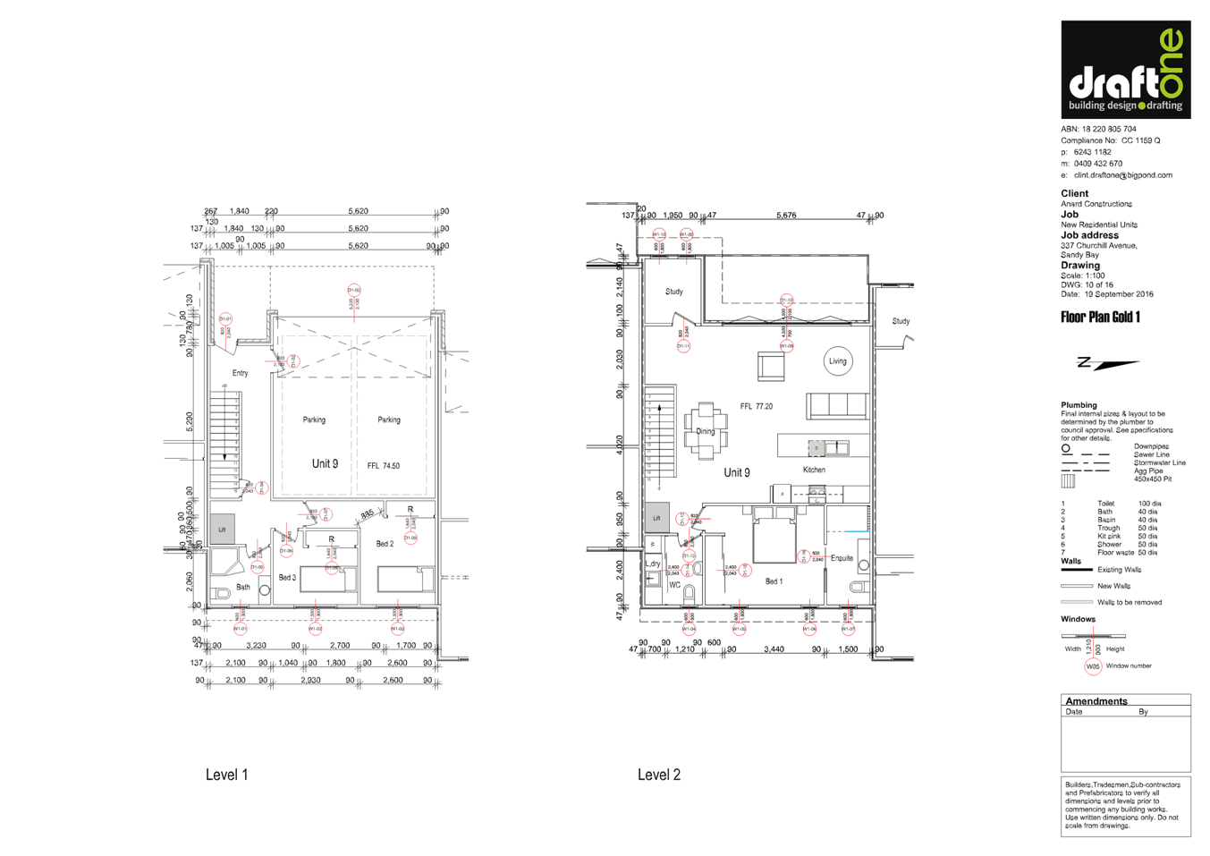
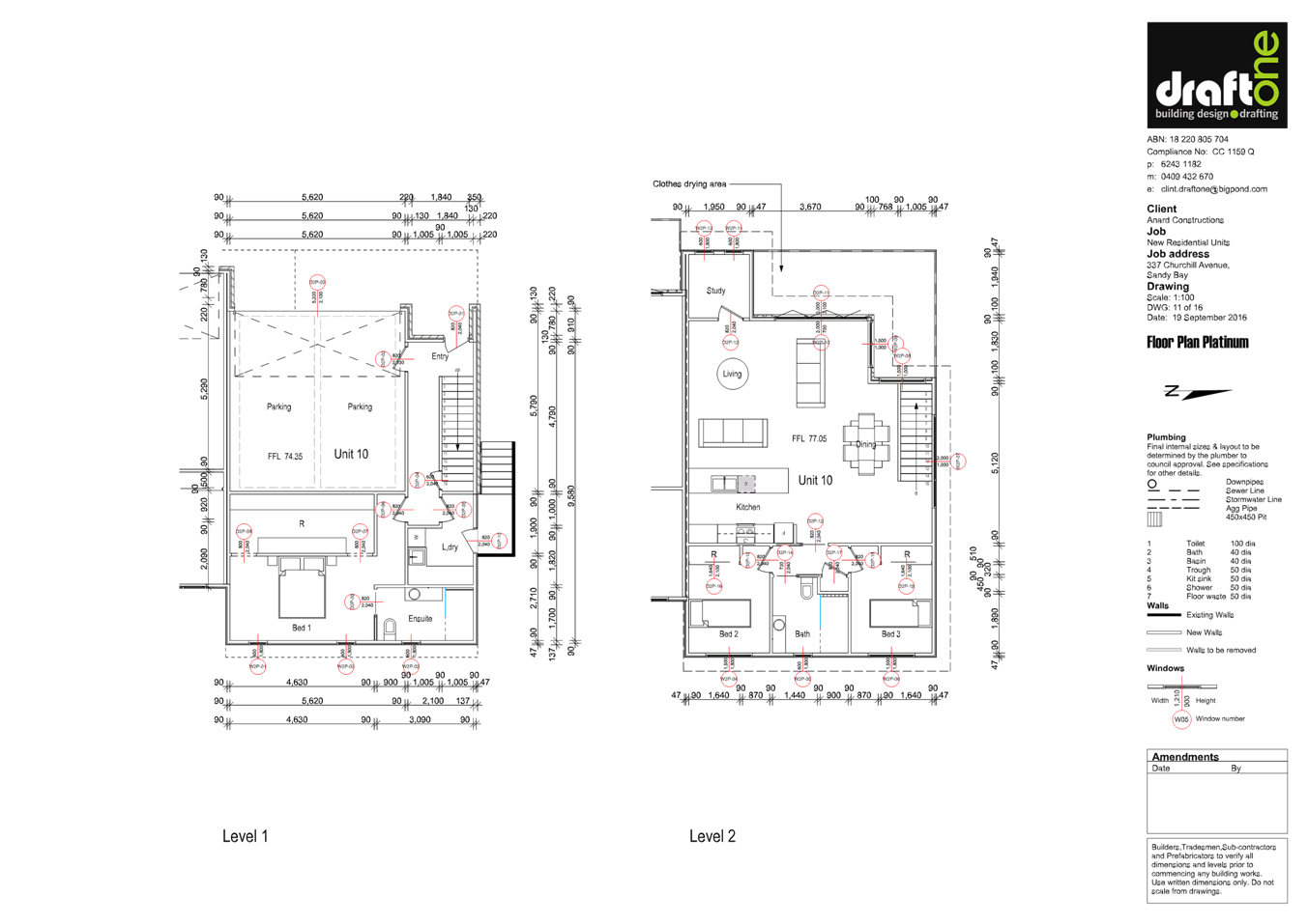
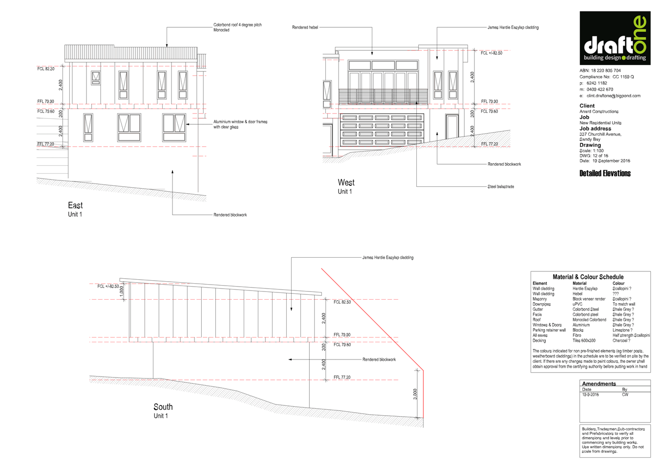
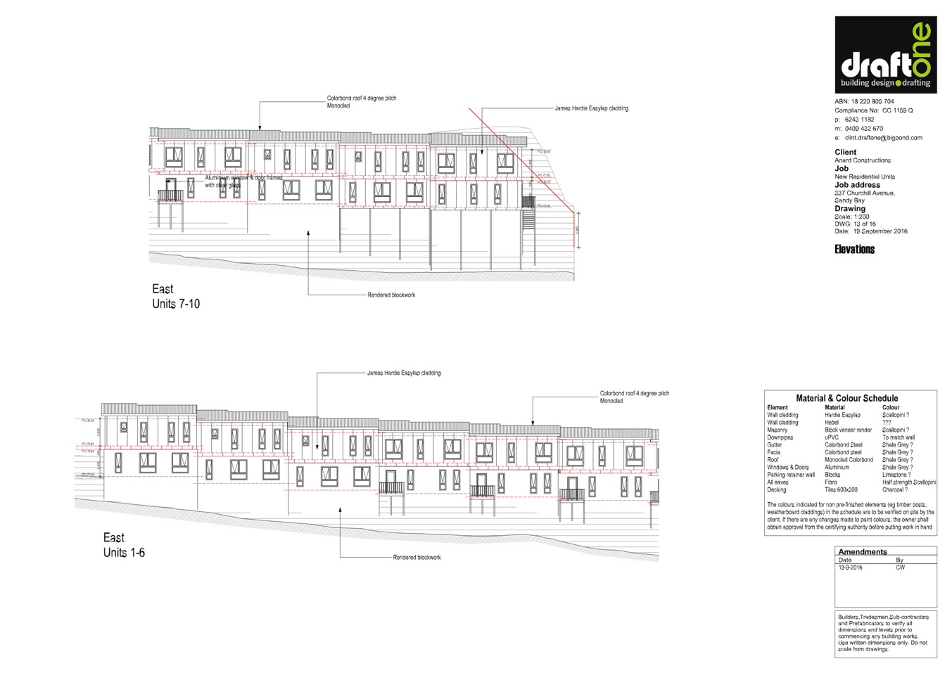
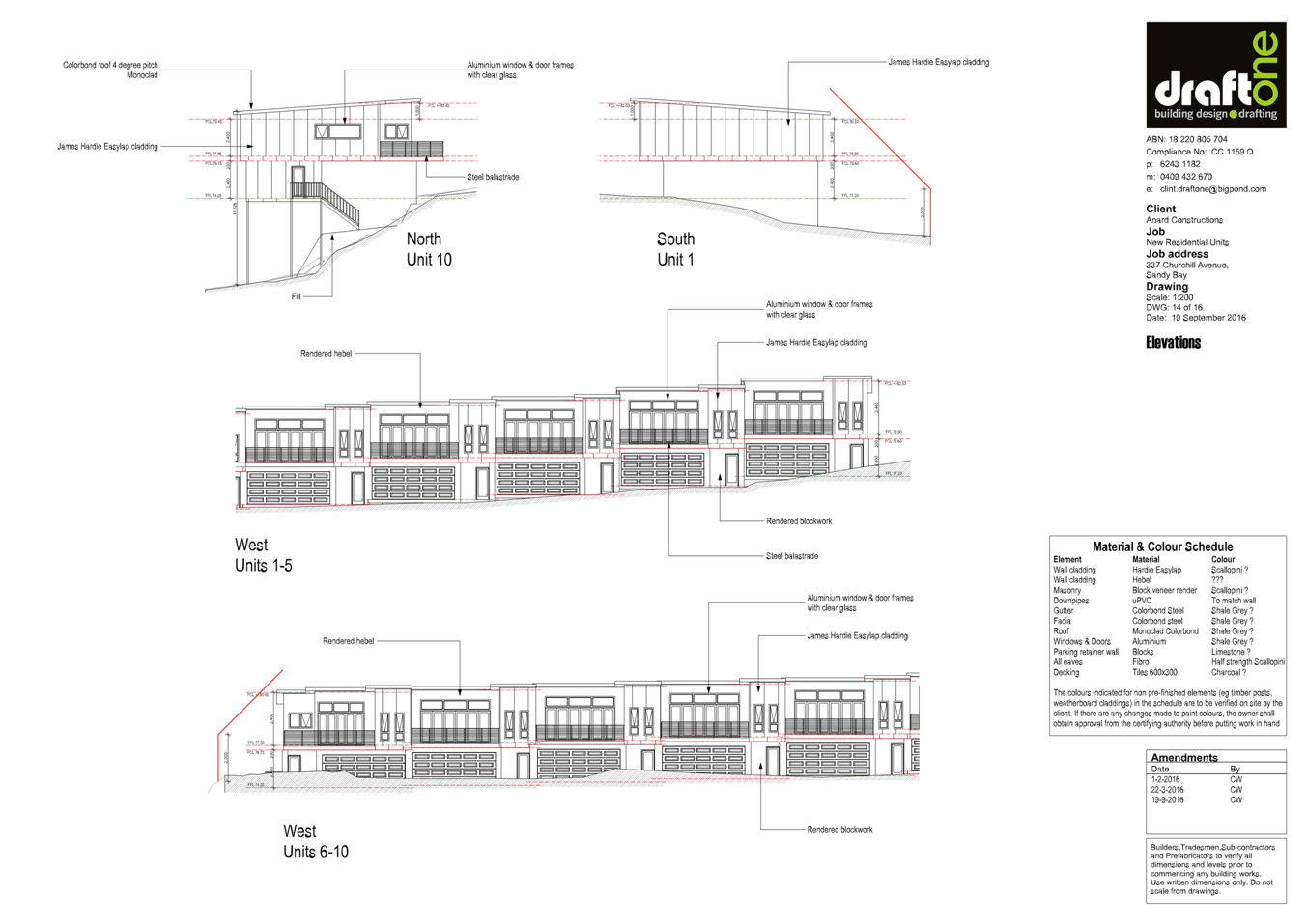
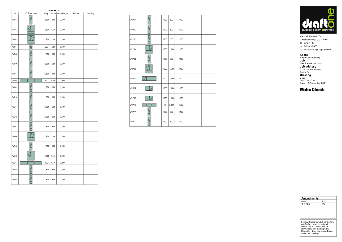
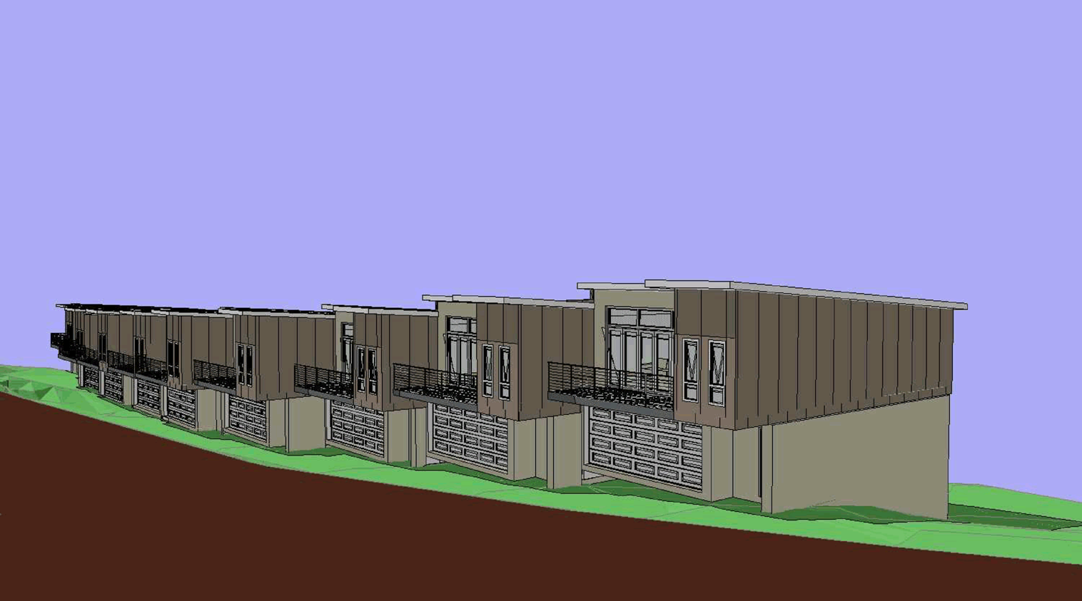
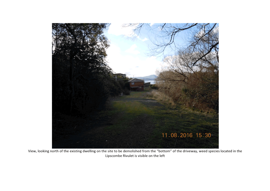
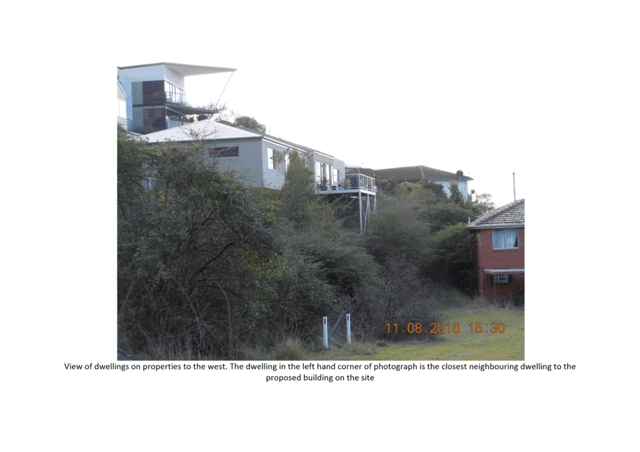
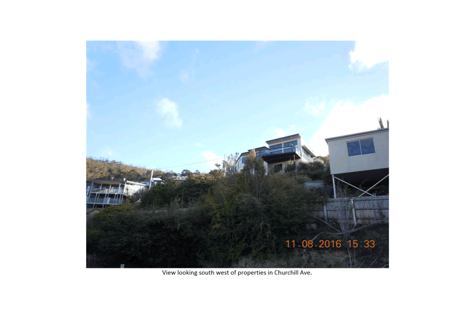
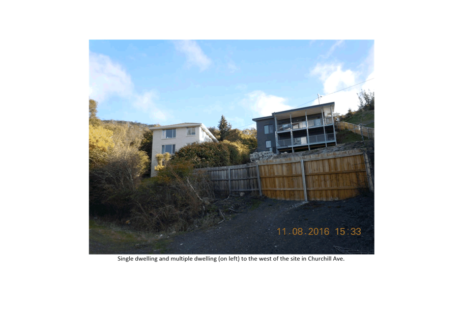
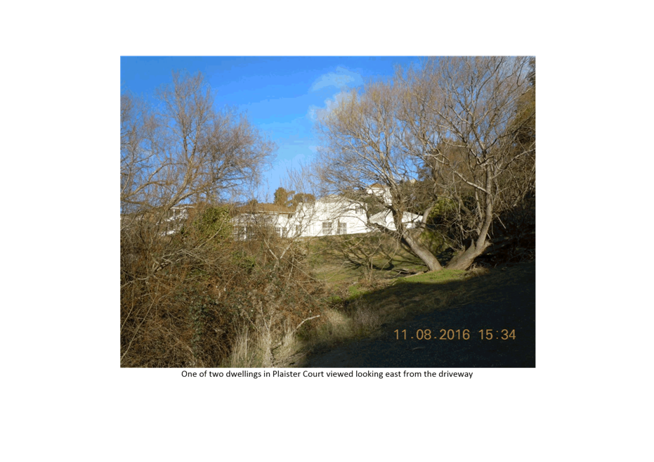
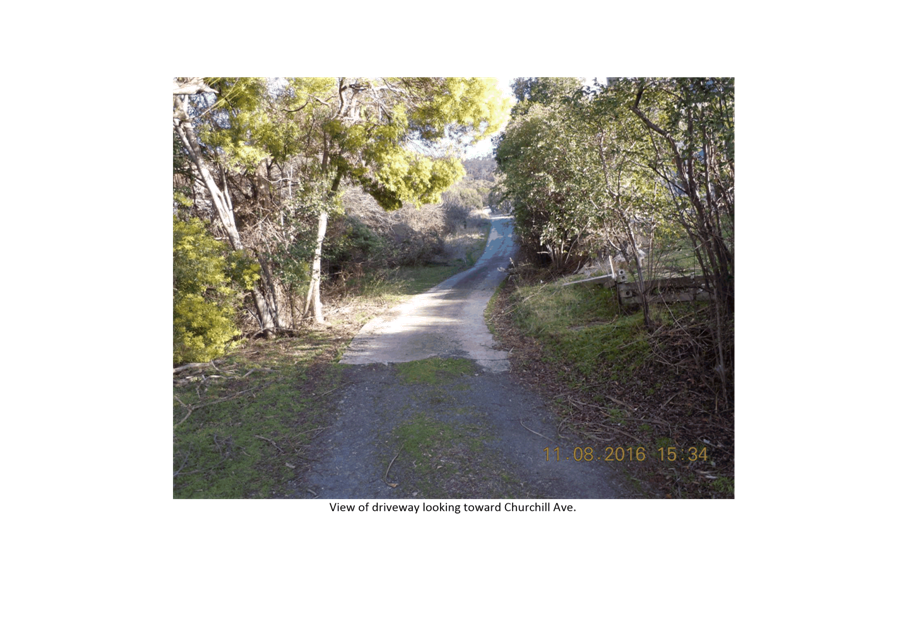
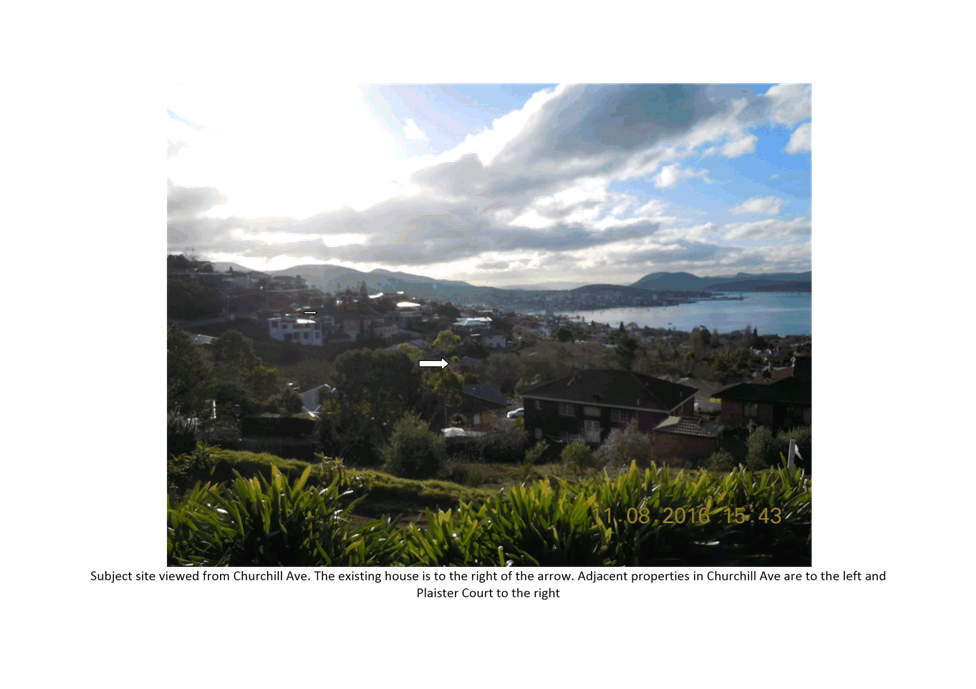
7.1.2 337 Churchill Avenue, Sandy Bay - Demolition and Ten Multiple Dwellings
PLN-16-00019-01 - FILE REF: F16/122502
Address: 337 Churchill Avenue, Sandy Bay
Proposal: Demolition and Ten Multiple Dwellings
Expiry Date: 9 November 2016
Extension of Time: Not applicable
Author: Michaela Nolan
|
REcommendation That pursuant to the Hobart Interim Planning Scheme 2015, the Council approve the application for a demolition and 10 multiple dwellings (readvertised amended design) at 337 Churchill Avenue, Sandy Bay for the reasons outlined in the officer’s report and a permit containing the following conditions be issued:
GEN
The use and/or development must be substantially in accordance with the documents and drawings that comprise PLN160001901 337 Churchill Ave SANDY BAY Final Planning Documents (amended) except where modified below.
Reason for condition
To clarify the scope of the permit.
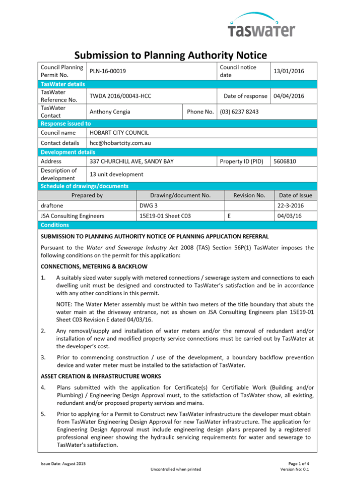
TW
The use and/or development must comply with the requirements of TasWater as detailed in the form Submission to Planning Authority Notice, Reference No. TWDA 2016/00043 HCC dated 3/10/16 as attached to the permit.
Reason for condition
To clarify the scope of the permit.
ENGsw2
The Council’s stormwater infrastructure adjacent to and within the subject site must be protected from damage during the construction of the development.
Digital copies of a pre construction work CCTV video and associated report(s) of any Council stormwater main within two metres of the works (which will not be replaced as part of the works) must be submitted to Council prior to issue of any consent under the Building Act 2000.
Digital copies of a post construction work CCTV video and associated report(s) of any Council stormwater main within two metres of the works must be submitted to Council after completion of all work but prior to the issue of any Certificate of Completion. However should the main still be within the 12 month maintenance period, this post work CCTV may instead be submitted at the end of the maintenance period (i.e a single CCTV to satisfy both maintenance period and post works).
The pre and post construction work CCTVs will be relied upon to establish the extent of damage caused to the Council’s infrastructure during construction.
In the event that the owner fails to provide to the Council a pre construction works CCTV video of the Council’s infrastructure, then any damage to the Council infrastructure identified in the post construction CCTV will be deemed to be the responsibility of the owner.
Reason for condition
To ensure the protection of Council’s hydraulic infrastructure.
ENGsw3
The proposed works (including footings and overhangs) must be designed to ensure the long term protection of and access to any of Council’s new, existing or diverted stormwater infrastructure.
A detailed design for all works within two metres of public stormwater
infrastructure certified by a suitably qualified engineer must be submitted and
approved prior
to issue of any consent under the Building Act
2000. The detailed design must: • Demonstrate how the design will ensure the protection of and provide access to Council’s stormwater mains; • Demonstrate that the works do not impose any loads on the storm water mains and the structures are entirely independent of the mains and their trenching, including certification by a suitably qualified engineer; • Include (but not be limited to) crosssections, minimum separation, adequate cover.
The entire section of stormwater main where access will be compromised by the development must be renewed at the Developer’s cost.
Prior to construction of any footings within two metres of public stormwater infrastructure, the stormwater pipe must be accurately located by the developer, and the clearance must be inspected and confirmed by the Council's Project and Development Inspector to ensure the minimum separation is achieved.
The Council's Project and Development Inspector, must be contacted on phone (03) 6238 2967 at least 24 hours prior to the commencement of any works.
Prior to issue of any certificate of completion for the relevant stage a suitably qualified engineer must confirm the installation of the works within two metres of Council’s stormwater main is in accordance with the approved drawings and complies with this condition. Should any remediation works be required, these must be carried out at the developer’s cost.
All work required by this condition must be undertaken in accordance with the approved design.
Advice: Once the detailed design drawings have been approved the Council will issue a condition endorsement (see general advice on how to obtain condition endorsement). The Council's Project and Development Inspector, must be contacted on phone (03) 6238 2967 at least 24 hours prior to the commencement of any works.
Council may wish to coordinate replacement of other sections of stormwater main in conjunction with the proposed works.
Reason for condition
To ensure the protection of Council’s hydraulic infrastructure.
ENGsw4
The site must be drained to Council infrastructure. The new stormwater connection(s) must be constructed, and existing redundant connections must be removed at the owner’s expense, prior to issue of a certificate of completion.
Detailed design drawings showing the
proposed connections must be submitted and
approved, prior to
issue of any
consent under the
Building Act 2000. The detailed design drawings must: • Show the location of the proposed connections and any existing connections; • Demonstrate the size and design of the connection(s) such that they are appropriate to safely service the development and ensure protection of the receiving waterway, including: · Erosion and scour protection, including maintenance of 3 month flows for the fully developed site; · Minimal hydraulic intrusion into the Rivulet; • Include longsections and crosssections of the proposed connection(s) clearly showing any nearby services, cover, size, material, delineation of public and private infrastructure; and • Be checked and certified by a qualified and experienced engineer.
All work required by this condition must be undertaken in accordance with the approved detailed design drawings.
Advice: Once the detailed design drawings have been approved the Council will issue a condition endorsement (see general advice on how to obtain condition endorsement).
Please note that once the condition endorsement has been issued you will need to contact Council’s City Infrastructure Division to initiate an application for service connection.
Reason for condition
To ensure the site is drained adequately.
ENGsw5
All new, renewed or upgraded public stormwater infrastructure must be constructed prior to issue of a completion certificate.
Engineering design drawings must
be submitted and
approved, prior to issue
of any consent under the Building Act 2000. The engineering drawings
must: • be certified by a qualified and experienced engineer show in both plan and longsection any proposed stormwater mains, including but not limited to: lot connections (proposed or existing for benefitting properties); clearances (e.g to buildings, structures, private pipework, other services, etc), cover, extent of fill, gradients, sizing, material, pipe class, adequate working platforms around manholes, connections to existing Council infrastructure, easements, inspection openings, property boundaries, and erosion control. • include a construction management plan which details how services to thirdparty land will be maintained during the pipe replacement process. • clearly distinguish between public and private infrastructure. • be substantially in accordance with the LGAT drawings.
All work required by this condition must be undertaken in accordance with the approved engineered drawings.
Advice: Once the engineering drawings have been approved the Council will issue a condition endorsement (see general advice on how to obtain condition endorsement).
Please note that once the condition endorsement has been issued you will need to contact Council’s Road and Environmental Engineering Unit to obtain a Permit to Construct Public Infrastructure. All new public infrastructure will be subject to a 12 month maintenance period before being taken over by Council (subject to satisfactory final inspection including CCTV) and will require payment of a maintenance bond. Note that the engineering drawings for public infrastructure are separate from and do not form part of any plumbing permit documentation.
Reason for condition
To ensure Council’s hydraulic infrastructure meets acceptable standards. To ensure Council’s hydraulic infrastructure meets acceptable standards.
ENGsw7
Stormwater pretreatment and detention for stormwater discharges from the development must be installed prior to issue of a Certificate of Completion.
A
stormwater management report
and design must
be submitted and approved, prior to issue
of any consent under the Building Act 2000. The stormwater management report and
design must: a) be prepared by a suitably qualified engineer; b) include detailed design of the proposed treatment train, including final estimations of contaminant removal; c) include detailed design and supporting calculations of detention, sized such that there is no increase in flows from the developed site up to the 5% AEP storm event; d) include a Stormwater Management Summary Plan that outlines the obligations for future property owners to stormwater management, including a maintenance plan which outlines the operational and maintenance measures to check and ensure the ongoing effective operation of all systems, such as: inspection frequency; cleanout procedures; descriptions and diagrams of how the installed systems operate; details of the life of assets and replacement requirements.
All work required by this condition must be undertaken and maintained in accordance with the approved stormwater management report and design.
Advice: Once the stormwater management report and design has been approved the Council will issue a condition endorsement (see general advice on how to obtain condition endorsement).
Reason for condition
To protect natural watercourses, to comply with relevant State Legislation.
ENG 2
Vehicle crash barriers compliant with the Australian/New Zealand Standard AS/ NZS 1170.1 must be installed prior to the first occupation if deemed necessary after review by a suitably qualified engineer.
If barriers are required, a certified design/ report prepared by a suitably qualified Engineer, to satisfy the above requirements, must be provided to the Council prior to the issuing of any permit under the Building Act 2000.
Alternatively, if barriers are not required, this must be confirmed to Council in writing by a suitably qualified Engineer prior to the issuing of any permit under the Building Act 2000.
All works, required by this condition must be undertaken in accordance with certified design/report. Upon completion the barriers must be inspected by a qualified engineer and a certification submitted to the Council, confirming that the installed barriers comply with the above requirement.
Reason for condition
To ensure that the safety of users of the driveway/parking and compliance with the standard.
ENG 4
The driveway and car parking areas approved by this permit must be constructed to a sealed standard and surface drained prior to the first occupation.
Reason for condition
To ensure safe access is provided for the use.
ENG 3
The driveway, car parking and manoeuvring areas must be constructed in accordance with certified driveway design drawings, prior to the first occupation.
The driveway, car parking and manoeuvring areas design must be submitted to the Council, prior to the issuing of any permit under the Building Act 2000.
The driveway, car parking and manoeuvring areas design must:
• Be prepared and certified by a suitably qualified engineer that the design is in accordance with the Australian Standards AS/NZS 2890.1 or that the design provides for a safe and efficient access.
Upon completion of the driveway, car parking and manoeuvring areas, documents signed by a suitably qualified engineer, certifying the driveway has been constructed in accordance with the certified design drawings must be lodged with the Council.
Reason for condition
To ensure that the safety of users of the driveway/parking.
ENG 1
The cost of repair of any damage or alterations to the Council infrastructure resulting from the implementation of this permit, must be met by the owners within 30 days of the completion of the development or as otherwise determined by the Council. Any damage must be reported immediately to Council.
A photographic record of the Council infrastructure adjacent to the subject site must be provided to the Council prior to any commencement of works.
A photographic record of the Council’s infrastructure (e.g. existing property service connection points, roads, buildings, stormwater, footpaths, driveway crossovers and nature strips, including if any, pre existing damage) will be relied upon to establish the extent of damage caused to the Council’s infrastructure during construction. In the event that the owner/developer fails to provide to the Council a photographic record of the Council’s infrastructure, then any damage to the Council infrastructure found on completion of works will be deemed to be the responsibility of the owner.
Reason for condition
To ensure that any of the Council infrastructure and/or siterelated service connections affected by the proposal will be altered and/or reinstated at the owner’s full cost.
ENGR 3
The proposed driveway crossover on the Churchill Ave highway reservation must be designed and constructed in accordance with:
• Urban TSDR09v1 – Urban Roads Driveways and TSD R14v1 Type KC vehicular crossing
All work required by this condition must be undertaken in accordance with the approved drawing.
Reason for condition
To ensure that works will comply with the Council’s standard requirements.
ENG s1
The proposed driveway, turning area, retaining walls, and Unit pole footings must be designed and constructed to resist all likely forces and erosion associated with proximity to Lipscombe Rivulet, including flood.
Detailed
design drawings of
all works within
the riparian zone
must be submitted and approved prior to the issue of consent under the Building Act.
The design drawings must include: • Certification from an accredited and qualified structural engineer that all proposed structures are designed to resist creek meander, erosion, undermining, and likely forces from a flood event; and • Crosssections showing the works and property boundaries.
All work required by this condition must be undertaken and maintained in accordance with the approved plans.
Reason for condition
To ensure that the risks associated with proximity to a watercourse are adequately managed.
ENG s2
All structures within the flood zone including buildings and flood mitigation measures must be inspected by a suitably qualified and accredited engineer.
Certification from a suitably qualified and accredited engineer that the installation has been constructed in accordance with the approved certified design must be provided to Hobart City Council prior issue of a completion certificate.
Reason for condition
To ensure that the risks associated with proximity to a watercourse are adequately managed.
ENG s3
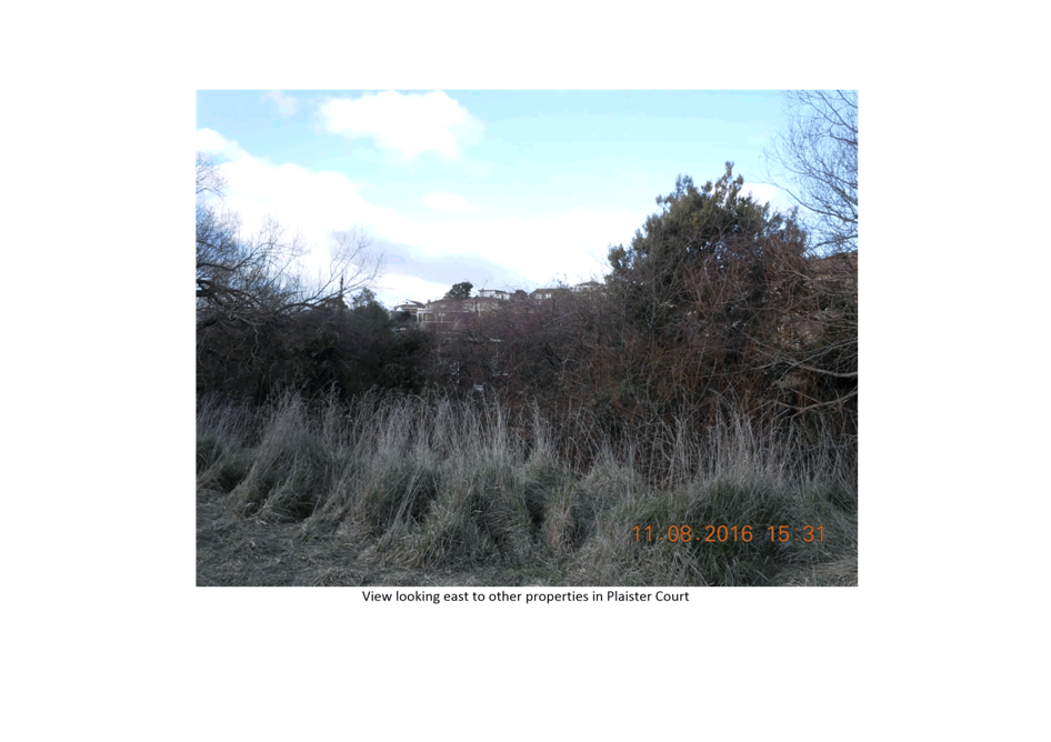
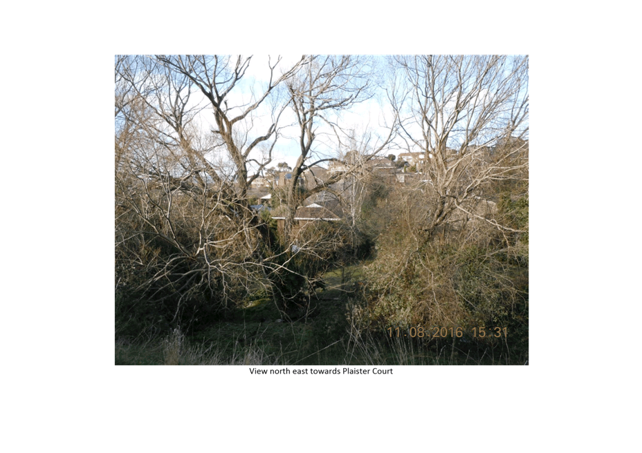
The capacity of Lipscombe Rivulet and the flood impact on neighbouring properties must not be detrimentally affected by the works.
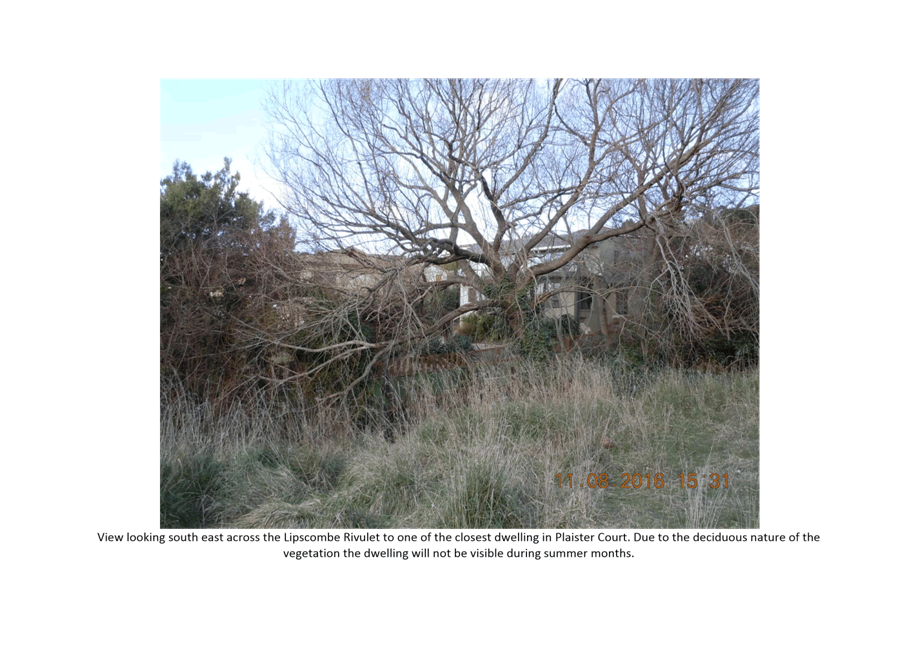
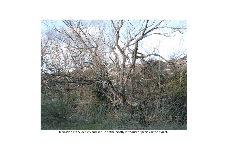
The willow tree in the creek must be removed (Scenario 3 of inundation modelling) as shown on concept drawing from JSA Engineers C14 Rev G prior to issue of a Certificate of Completion.
Reason for condition
To ensure that the risk of flooding to adjacent properties is not increased.
ENV 8
All recommended risk mitigation measures in the "Conclusions" section of the landslide risk management report by GeoEnvironmental Solutions dated June 2016 must be implemented and must be maintained for the life of the use/development.
Reason for condition
To reduce the risk to life and property, and the cost to the community, caused by landslides.
ENV2
Sediment and erosion control measures, in accordance with an approved soil and water management plan (SWMP) must be installed, prior to the commencement of work and maintained until such time as all disturbed areas have been stabilised and/or restored or sealed to the Council’s satisfaction.
A soil and water management plan (SWMP) must be submitted and approved, prior to the commencement of work. The SWMP must:
a. be prepared in accordance with the Soil and Water Management on Building and Construction Sites fact sheets (Derwent Estuary Program, 2008). http://www.hobartcity.com.au/Development/Engineering_Standards_and_Gui deline All work required by this condition must be undertaken in accordance with the approved soil and water management plan (SWMP).
Advice: Once the soil and water management plan (SWMP) has been approved the Council will issue a condition endorsement (see general advice on how to obtain condition endorsement).
Reason for condition
To avoid the pollution and sedimentation of roads, drains and natural watercourses that could be caused by erosion and runoff from the development.
ADVICE
The following advice is provided to you to assist in the implementation of the planning permit that has been issued subject to the conditions above. The advice is not exhaustive and you must inform yourself of any other legislation, bylaws, regulations, codes or standards that will apply to your development under which you may need to obtain an approval. Visit www.hobartcity.com.au for further information.
Prior to any commencement of work on the site or commencement of use the following additional permits/approval may be required from the Hobart City Council.
CONDITION ENDORSEMENT
If a condition endorsement is required by a planning condition above, you will need to submit the relevant documentation to satisfy the condition, via the Condition Endorsement Submission on Council's online eservice portal.
Once approved, the Council will respond to you via email that the condition(s) has been endorsed (satisfied). Detailed instructions can be found at: http://www.hobartcity.com.au/Development/Planning/How_to_obtain_a_condition_e ndorsement
BUILDING PERMIT
Building permit in accordance with the Building Act 2000;
http://www.hobartcity.com.au/Development/Building
PLUMBING PERMIT
Plumbing permit under the Tasmanian Plumbing Regulations 2014;
http://www.hobartcity.com.au/Development/Plumbing
STORMWATER
Please note that in addition to a building and/or plumbing permit, development must be in accordance with the Hobart City Council’s Hydraulic Services By law.
http://www.hobartcity.com.au/Council/Legislation
ACCESS
Designed in accordance with LGAT IPWEA – Tasmanian standard drawings
http://www.hobartcity.com.au/Development/Engineering_Standards_and_Guidelines
The construction of the crossover can be undertaken by the Council or by a private contractor, subject to Council approval of the design.
STORMWATER / ROADS / ACCESS
Services to be designed and constructed in accordance with the (IPWEA) LGAT – standard drawings. http://www.hobartcity.com.au/Development/Engineering_Standards_and_Guidelines
All work carried out in close proximity to the Council reserves must be in accordance with the Council’s Parks, recreation and natural areas by laws http://www.hobartcity.com.au/Council/Legislation
You are subject to the Council’s Parks, recreation and natural areas by –laws in respect to any work carried out in close proximity to the Council reserve.
http://www.hobartcity.com.au/Council/Legislation
WEED CONTROL
Effective measures are detailed in the Tasmanian Washdown Guidelines for Weed and Disease Control: Machinery, Vehicles and Equipment (Edition 1, 2004). The guidelines can be obtained from the Department of Primary Industries, Parks, Water and Environment website at http://dpipwe.tas.gov.au/invasivespecies/weeds/weed hygiene/washdownguidelines.
WASTE
DISPOSAL TOP
TEN TIPS DIAL BEFORE YOU DIG
If you do not have access to the Council’s electronic web page, please phone the Council (City Planning) on 62382715 for assistance.
|
Attachment
a: PLN-16-00019-01
- 337 Churchill Avenue - SANDY BAY - Demolition and 13 Multiple Dwellings ⇩ ![]()
Attachment
b: PLN-16-00019-01
- 337 Churchill Avenue SANDY BAY CPC Agenda Documents
⇩ ![]()
|
Item No. 7.1.2 |
Agenda (Open Portion) City Planning Committee Meeting - 31/10/2016 |
Page 150 ATTACHMENT a |

|
Agenda (Open Portion) City Planning Committee Meeting - 31/10/2016 |
Page 181 ATTACHMENT b |

|
Item No. 7.1.2 |
Agenda (Open Portion) City Planning Committee Meeting - 31/10/2016 |
Page 198 ATTACHMENT b |
|
Item No. 7.1.2 |
Agenda (Open Portion) City Planning Committee Meeting - 31/10/2016 |
Page 200 ATTACHMENT b |

|
Item No. 7.1.2 |
Agenda (Open Portion) City Planning Committee Meeting - 31/10/2016 |
Page 203 ATTACHMENT b |
|
Item No. 7.1.2 |
Agenda (Open Portion) City Planning Committee Meeting - 31/10/2016 |
Page 219 ATTACHMENT b |
|
Agenda (Open Portion) City Planning Committee Meeting |
Page 223 |
|
|
|
31/10/2016 |
|
8 Reports
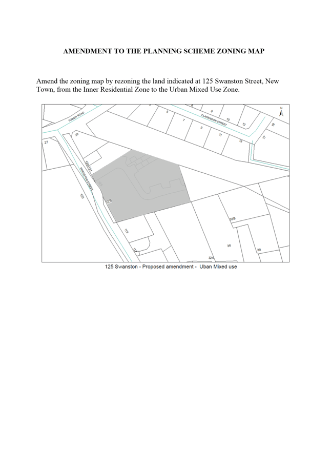
8.1 Hobart Interim Planning Scheme 2015 - Planning Scheme Amendment PSA-16-9 - 125 Swanston Street Rezoning
File Ref: F16/113654
Report of the Manager Planning Policy and Heritage of 25 October 2016 and attachments.
Delegation: Council
|
Item No. 8.1 |
Agenda (Open Portion) City Planning Committee Meeting |
Page 224 |
|
|
31/10/2016 |
|
REPORT TITLE: Hobart Interim Planning Scheme 2015 - Planning Scheme Amendment PSA-16-9 - 125 Swanston Street Rezoning
REPORT PROVIDED BY: Manager Planning Policy and Heritage
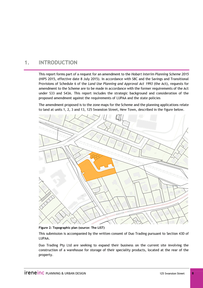
1. Report Purpose and Community Benefit
1.1. This report proposes an amendment to the City of Hobart Interim Planning Scheme 2015 (HIPS 2015) for the rezoning of part of 125 Swanston Street from Inner Residential to Urban Mixed Use.
1.2. The proposal benefits the community by ensuring that land is appropriately zoned.
2. Report Summary
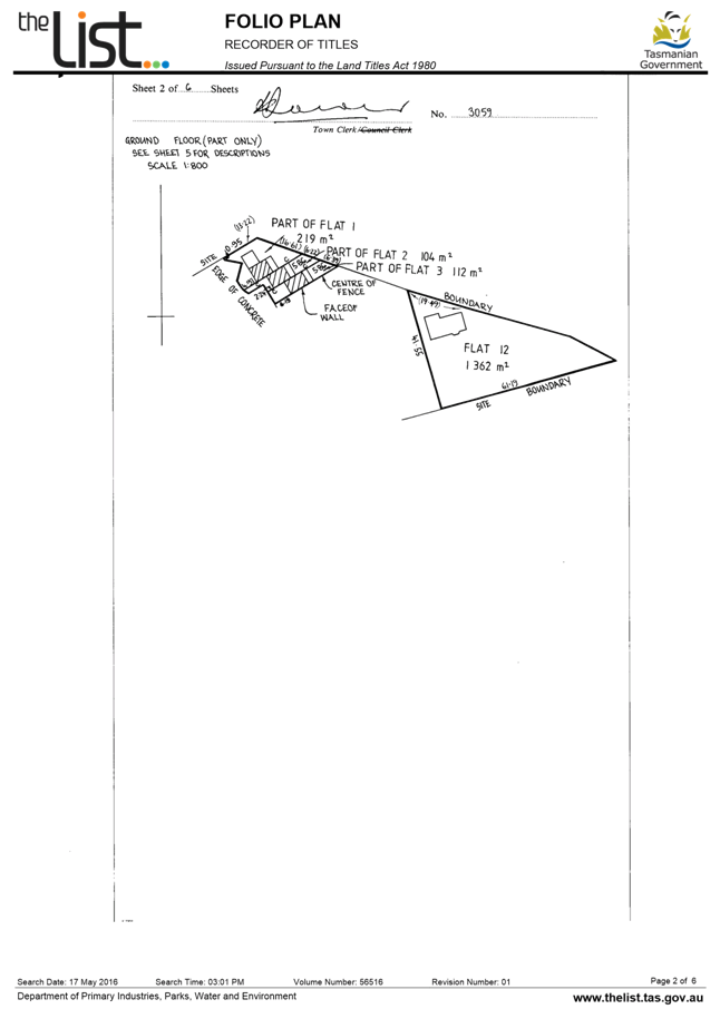
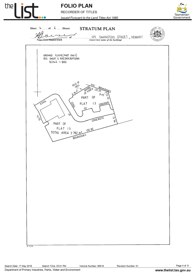
2.1. The proposal is to rezone 125 Swanston Street New Town, excluding the area of land associated with ‘Flat 12’ on the Stratum Plan, from Inner Residential to Urban Mixed Use.
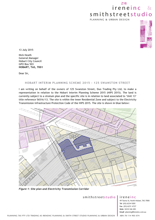
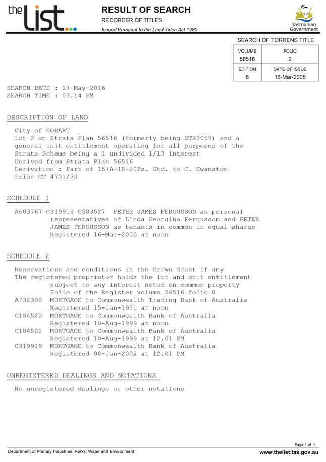
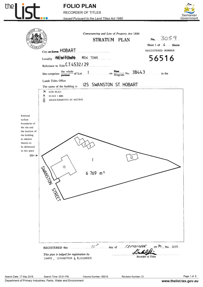
2.2. 125 Swanston Street is a fully serviced site that contains 4 residential dwellings and an office and warehouse related to the sale of automotive lubricants and oils. The site is subject to a Stratum Plan.
2.3. The subject site is partially covered by a wayleave easement associated with high transmission powerlines running through the southern section of the site. There are two large transmission towers on the site.
2.4. The subject site is adjacent to a railway reservation (including the intercity cycleway) to the north/east.
2.5. The commercial use on the site has been in operation since 1979 and has existing use rights to continue, however options for alterations or expansions to the use are very limited under the Inner Residential Zone.
2.6. The desire for more scope to expand the commercial operation on the site was the subject of a representation to the HIPS 2015. In its response, Council acknowledged that there was some merit to considering a proposal to rezone the site.
2.7. The proposed rezoning is considered to be an appropriate amendment to the HIPS 2015 for the following reasons:
2.7.1. The site is not an attractive location for further residential development due to the wayleave easement, proximity to the railway corridor and the existing commercial development on the site.
2.7.2. The Urban Mixed Use Zone will more accurately reflect the current mix of uses on the site and acknowledge the constraints to further residential development.
2.7.3. The provisions of the Urban Mixed Use Zone seek to control potential impacts from commercial development, and the likely development area on the site is buffered from surrounding residential land by existing buildings on the site, the railway corridor and the wayleave easement.
2.7.4. The rezoning complies with the policies of the Southern Tasmania Regional Land Use Strategy (STRLUS), which encourage urban infill development and efficient utilisation of existing infrastructure.
2.7.5. Rezoning the site Urban Mixed Use is a simpler and more effective option than drafting a specified departure for the site to specifically allow for expansion of the commercial use.
|
That: 1. Pursuant to Section 34(1) (b) of the former provisions of the Land Use Planning and Approvals Act 1993, the Council resolve to initiate an amendment to the Hobart Interim Planning Scheme 2015 to rezone part of the property at 125 Swanston Street, New Town from Inner Residential to Urban Mixed Use, as indicated on the plan in Attachment A. 2. Pursuant to Section 35 of the former provisions of the Land Use Planning and Approvals Act 1993, the Council certify that the Amendment to the Hobart Interim Planning Scheme PSA-16-9 meets the requirements of Section 32 of the former provisions of the Land Use Planning and Approvals Act 1993 and authorise the General Manager and the Deputy General Manager to sign the Instrument of Certification (Attachment F). 3. Pursuant to Section 38 of the former provisions of the Land Use Planning and Approvals Act 1993, the Council place Amendment PSA-16-9 to the Hobart Interim Planning Scheme 2015 on public exhibition for a 28 day period following certification.
|
4. Background
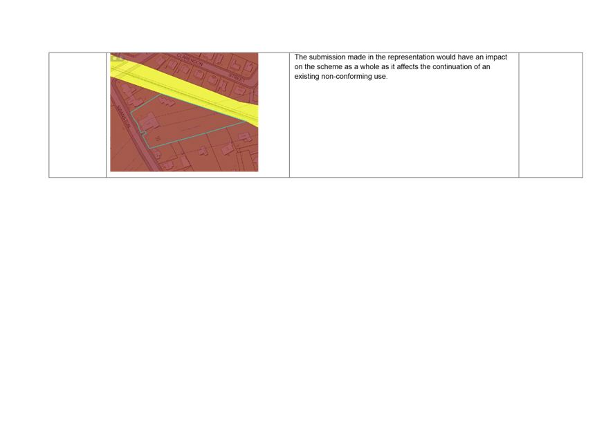
4.1. A desire for more flexible provisions for the existing commercial operation at 125 Swanston Street was the subject of a representation made in response to the exhibition of the HIPS 2015 (see Attachment B).
4.2. The representation submitted that the long term non-conforming use of the site should be acknowledged and accounted for within the provisions of the scheme, potentially by way of a local provision within the use table for the Inner Residential Zone.
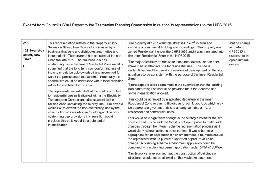
4.3. Council responded in its report under S30J of LUPAA (submitted to the Tasmanian Planning Commission in response to the representations received) that the submission had some merit (see excerpt in Attachment C).
4.4. It was noted in the S30J report that acknowledgement of the site’s use could be achieved either by a specified departure in the Inner Residential Zone (as proposed in the submission) or by rezoning the site Urban Mixed Use, given the site already contains a mix of uses.
It was concluded, however, that such an alteration would be a significant change in the strategic intent for the site and it was therefore not considered appropriate to make such a change through the HIPS 2015 hearing process. It was suggested that an application be made by the applicant for a planning scheme amendment.
4.5. The owner of the site submitted an application on 1 September 2016 to rezone 125 Swanston Street, excluding the land associated with strata unit 12 and excluding common land (access and parking) (see submission in Attachment D).
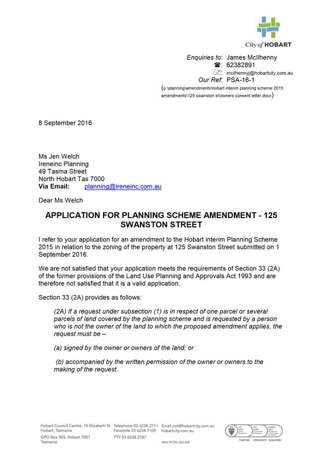
4.6. The application was reviewed, and following legal advice, was determined to be invalid and the applicant was notified (see letter in Attachment E). The application was subsequently withdrawn on 21 September 2016.
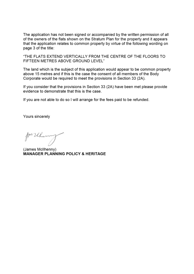
4.7. The legal advice obtained by Council considered that the application failed Section 33 (2A) of LUPAA, which requires a request for an amendment to be signed by the owner or owners, or accompanied by the written permission of the owner or owners to the making of the request.
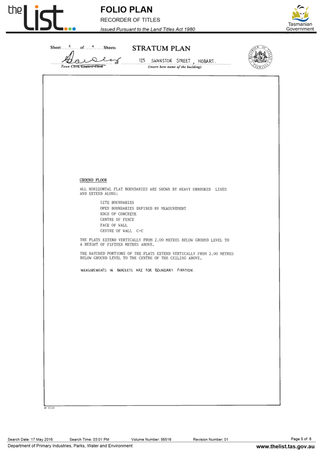
4.8. One strata title owner did not consent to the making of the request. The applicant intended to resolve this issue by excluding unit 12 and common land from the rezoning. However, the Stratum Plan for the property notes the following:
The flats extend vertically from the centre of the floors to fifteen metres above ground level.
Given this wording, the vertical area beyond 15m height is technically ‘common land’, and the rezoning would not be restricted to 15m vertically. As such, the consent of all owners would be required for the application to proceed.
4.9. The applicant was unable to gain the consent of the owner of strata unit 12/125 Swanston Street, and was therefore unable to pursue the amendment.
4.10. Council, in initiating an amendment, is not bound by the requirements of S33 (2A), and could therefore initiate a rezoning of 125 Swanston Street without the consent of all strata owners.
4.11. Given the unexpected legal issues, and the fact that Council noted there was merit to the rezoning in the 30J report, it is considered appropriate that the Council initiate the amendment in this instance.
4.12. The proposed rezoning area excludes unit 12/125 Swanston Street given the wishes for the owner to retain residential zoning for this area, however the common access and parking areas are included to ensure that the zone is not unnecessarily fragmented (see plan in Attachment A).
4.13. It is noted that the owner of Flat 12/125 Swanston Street will have the opportunity to make a representation following exhibition of the proposed amendment, and that any representations will be considered by Council.
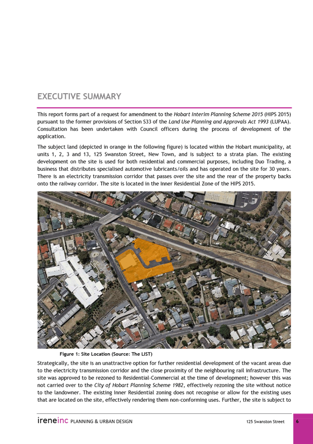
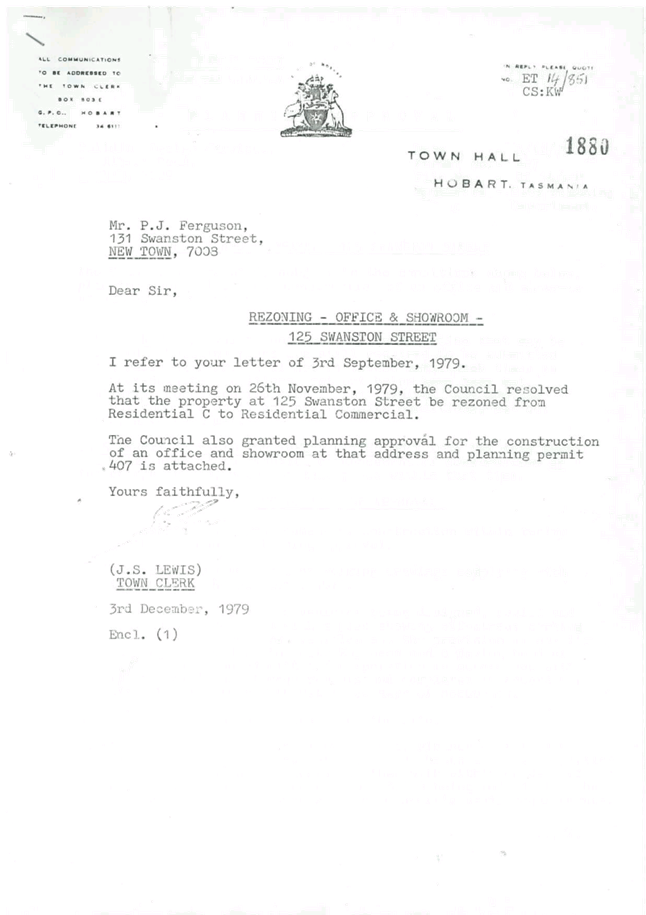
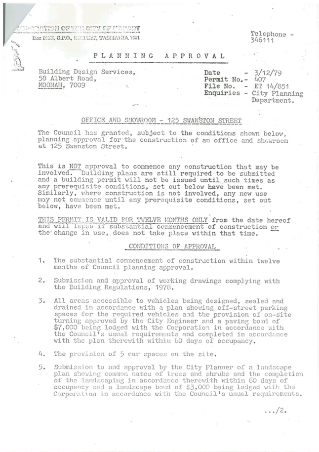
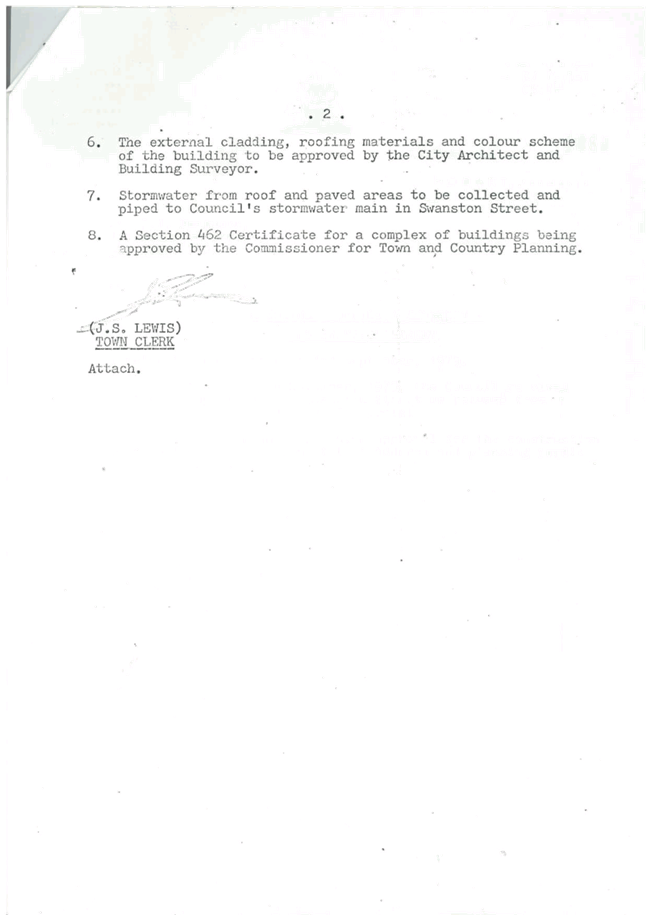
Existing Situation
4.14. 125 Swanston Street is a 6,769m2 serviced property which contains a number of existing buildings (see Figure 1 below).
4.15. The site is subject to a Stratum Plan delineating 5 strata titled areas. One of these strata titles (13/125 Swanston Street) contains a commercial operation (Duo Trading) that distributes specialised automotive lubricants and oils.
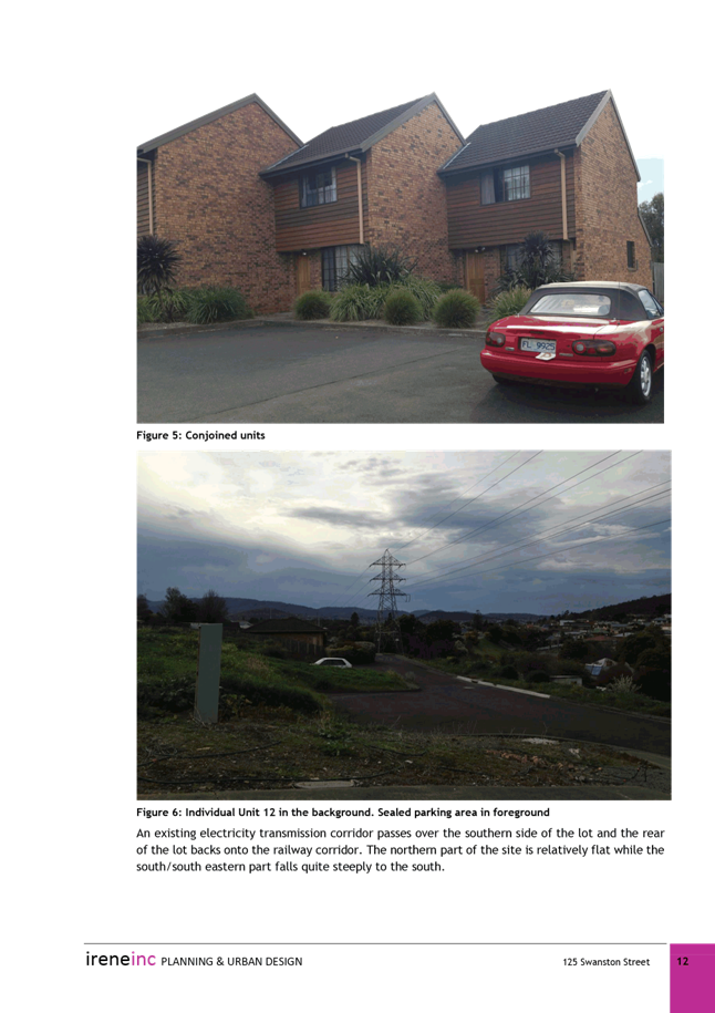
4.16. The business was granted a planning permit in 1979 for ‘showroom and office’. The main office fronts Swanston Street, and a showroom/storage building is located to the rear of this office.
4.17. The remaining 4 strata titles contain residential dwellings. Flats 1, 2 and 3 are conjoined terraces, and Flat 12 is a separate house.
4.18. Flats 1, 2, 3 and 13 are all held by Duo Trading, and Flat 12 is in separate ownership.
4.19. The site adjoins the railway corridor (including the Intercity Cycleway) to the north-east.
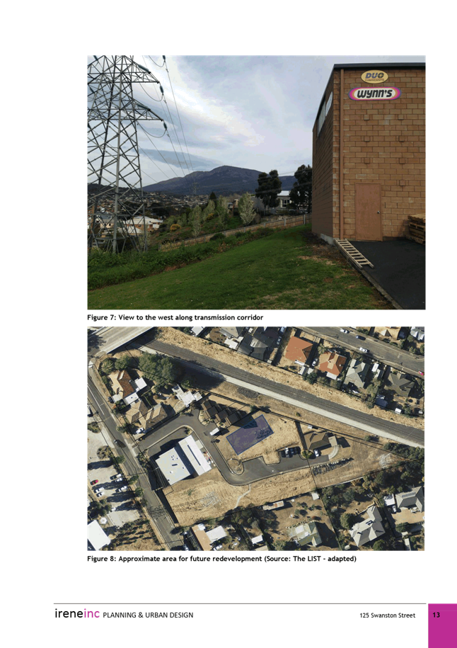
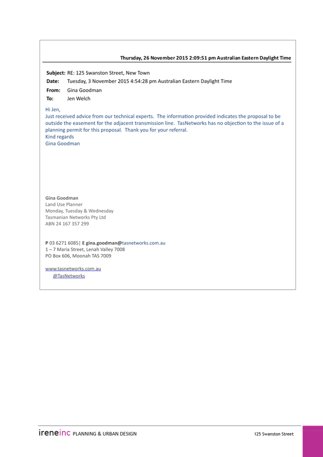
4.20. An electricity transmission corridor runs through the site along the southern boundary, and there are two large transmission towers on the site. The associated wayleave easement is approximately 25m wide, and all buildings on the site are currently located outside of this easement. TasNetworks confirm that no new buildings or structures could be constructed within the easement.
4.21. Uses surrounding the site are mainly residential, generally single dwellings. Opposite the site is a large aged care facility (Barrington Lodge). The site is located reasonably close to the shopping complex (New Town Plaza) on Risdon Road, and is also reasonably close to New Town and Ogilvie High Schools.
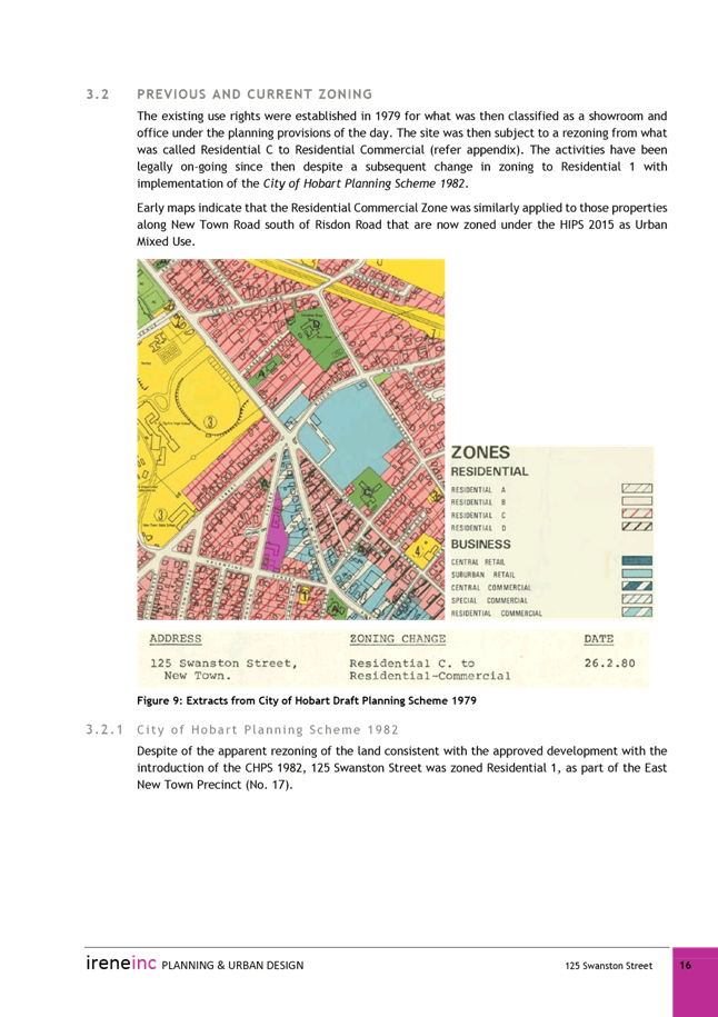
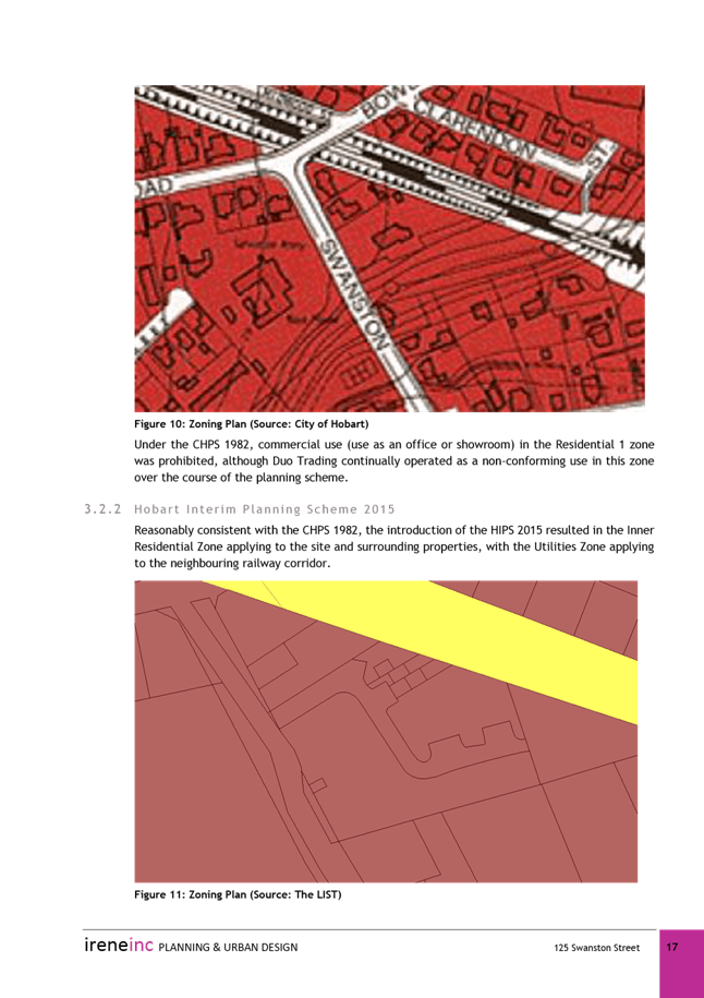
4.22. The entire site is zoned Inner Residential under the HIPS 2015, which was a direct translation from the Residential 1 Zone under the City of Hobart Planning Scheme 1982 (CHPS 1982).

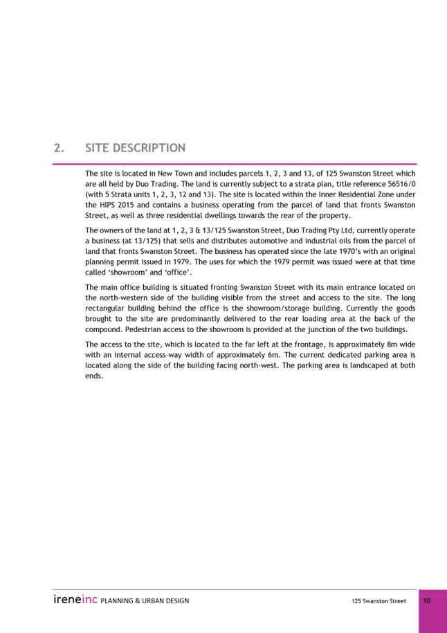
Figure 1: 125 Swanston Street (outlined in dotted blue) showing existing zoning (maroon: Inner Residential, yellow: Utilities). Wayleave easement shown in hatched blue.
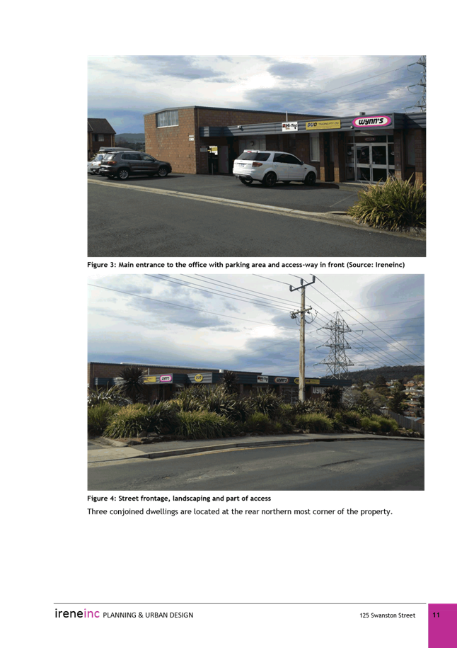
Figure 2: site entrance showing commercial buildings to the right and three conjoined dwellings to the left.
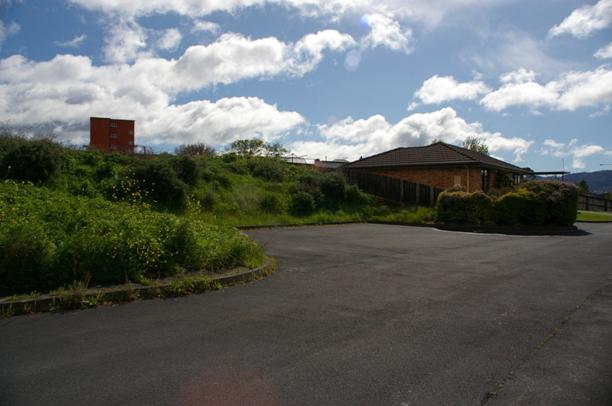
Figure 3: Flat 12/125 Swanston Street

Figure 4: transmission tower, showing existing showroom/storage building to the right.
Planning Scheme Provisions
4.23. The Zone Purpose Statements for the Inner Residential Zone are:
To provide for a variety of residential uses and dwelling types close to services and facilities in inner urban and historically established areas, which uses and types respect the existing variation and patter in lot sizes, set back and height.
To provide for compatible non-residential uses that primarily serve the local community.
To encourage residential development at higher densities in locations within walkable distance of services, facilities, employment and high frequency public transport corridors.
To encourage residential development that respects the neighbourhood character.
To provide a high standard of residential amenity.
To allow commercial uses which provide services for the needs of residents of a neighbourhood and do not displace an existing residential use or adversely affect their amenity particularly through noise, traffic generation and movement, and the impact of demand for on-street parking.
4.24. Within the Inner Residential Zone, single dwellings are no permit required, with other residential use classes (except more intense home based businesses) and visitor accommodation permitted. Some non-residential uses such as food services, general retail and hire and limited business and professional services uses are discretionary if in existing buildings and not displacing residential uses. A number of community uses such as community meeting and entertainment, educational and occasional care, emergency services and sport and recreation are also discretionary.
4.25. Use standards and development standards are aimed towards protecting residential amenity, although they encourage a higher density of residential development.
4.26. The Zone Purpose Statements for the Urban Mixed Use Zone are:
To provide for integration of residential, retail, community services and commercial activities in urban locations.
To encourage use and development at street level that generates activity and pedestrian movement through the area.
To provide for design that maximises the amenity at street level including considerations of microclimate, lighting, safety, and pedestrian connectivity.
To ensure development is accessible by public transport, walking and cycling.
To provide for a diversity of uses at densities responsive to the character of streetscapes, historic areas and buildings and which do not compromise the amenity of surrounding residential areas.
To encourage the retention of existing residential uses and the greater use of underutilised sites as well as the reuse and adaptation of existing buildings for uses with a scale appropriate to the site and area.
To ensure that the proportions, materials, openings and decoration of building facades contribute positively to the streetscape and reinforce the built environment of the area in which the site is situated.
To maintain an appropriate level of amenity for residential uses without unreasonable restriction or constraint on the nature and hours of commercial activities.
To ensure that retail shopping strips to not develop along major arterial roads within the zone.
4.27. Within the Urban Mixed Use Zone, low intensity home based businesses are no permit required, with other residential use classes permitted. Other permitted uses include business and professional services, community meeting and entertainment, food services unless with a drive through facility, and general retail and hire at the New Town Plaza shopping centre. There are a wide range of discretionary uses, including but not limited to bulky goods sales, equipment and machinery sales and hire, hotel industry, service industry, vehicle fuel sales and service and visitor accommodation.
4.28. It is likely the current commercial uses on the site would be categorised as ‘business and professional services’ and ‘storage’ or ‘general retail and hire’. Business and professional services is a permitted use in the zone, and general retail and hire and storage are both discretionary.
4.29. The use and development standards acknowledge the mixed use environment, are more flexible for non-residential uses, and have fewer provisions relating to residential amenity.
4.30. In terms of Codes, both E5.0 Road and Railway Assets Code and E8.0 Electricity Transmission Infrastructure Protection Code would apply to any new development on the site. The Potentially Contaminated Land Code is also likely to apply.
5. Proposal and Implementation
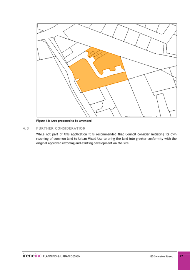
5.1. The proposal is to rezone the majority of the site at 125 Swanston Street, excluding the land associated with strata unit 12, from Inner Residential to Urban Mixed Use to enable uses and development that are suitable for the site (see Attachment A).
Justification
5.2. Given the wayleave easement over a large area of the site, the proximity to the rail corridor and the existing presence of commercial buildings, the site is not ideal for further residential development.
5.3. The use of the majority of the site area for commercial purposes has been established since 1979, and although existing use rights enable the use to continue, it is very restricted in terms of alterations or expansion.
5.4. As the site is not an attractive prospect for residential densification, rezoning the site to allow for some expansion of the existing business, and therefore providing for more efficient utilisation of the site, can be considered a reasonable outcome.
5.5. The Urban Mixed Use Zone reflects the existing mixed nature of uses on the site, and allows for a greater variety of non-residential uses.
5.6. Excluding the area of land covered by the wayleave easement (where buildings cannot be constructed), the only area of land that is available for physical development (assuming existing buildings are retained) is to the north of the site, alongside the rail corridor (see Figure 6 below). This area is within the land associated with Flat 13, which contains the existing commercial buildings.
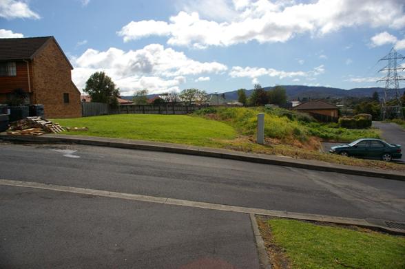
Figure 5: likely future development site, showing existing conjoined dwellings to the left, Flat 12 to the right, and transmission tower to the far right.
5.7. The likely development area lessens the potential for impacts on adjoining residential titles, as the area is bound to the north by the rail corridor and existing onsite residential units, the south by the wayleave easement, and the west by the existing commercial buildings.
5.8. Any additional development on the site does have the potential to impact on the existing residential uses on the site. The likely development area is close to existing Flats 1-3, and has the greatest potential to impact on these dwelling units. The potential for land use conflict is ameliorated to some degree by the fact that all three conjoined residential units are owned by the potential developer.
5.9. The Urban Mixed Use Zone also provides use and development standards that are intended to lessen the impacts of commercial development on residential uses. For example, use standards control issues such as hours of operation, noise, external lighting and commercial vehicle movements.
5.10. Development standards are specifically tailored to provide a greater degree of amenity to adjacent sites within a residential zone. Building heights, setbacks, design and landscaping are more tightly controlled in close proximity to residential zones.
5.11. Unit 12, which will be retained within the Inner Residential Zone due to the wishes of the landowner, will therefore be afforded particular amenity protection. Flat 12 is further insulated by impacts from potential development by the existing topography, as there is some separation between Flat 12 and the likely development area due to an embankment (see Figure 3).
5.12. Under the Urban Mixed Use Zone, the height limit and setbacks within proximity of a residential zone are in fact more restrictive than under the Inner Residential Zone, which could result in development under the Urban Mixed Use Zone potentially having less impact on Unit 12 than development under the Inner Residential Zone.
5.13. Rezoning the site, which is surrounded by the Inner Residential Zone (except for the Utilities zoned rail corridor to the north), is effectively a ‘spot zoning’. Given the existing site constraints and existing mix of uses on the site, however, it is considered to be the most logical solution.
5.14. The Southern Tasmania Regional Land Use Planning Strategy (STRLUS) is the document that guides the strategic development of land in the southern region. The proposed rezoning does not contravene the STRLUS, in that it will facilitate the efficient use of an underdeveloped site within an established urban area and maximise the efficiency of existing infrastructure.
5.15. The subject site is located within 400m of an integrated transit corridor as identified in the STRLUS, and policy LUTI 1.2 states ‘allow higher density residential and mixed use developments within 400, and possibly up to 800 metres (subject to topographic and heritage constraints) of integrated transit corridors. The site is not highly suitable for dwelling development, however, and therefore the rezoning does not compromise the achievement of realistic residential densification in this area.
5.16. The rezoning is considered to be the most logical outcome to ensure the site is utilised to its maximum capacity. Rezoning the site to a suitable zone is a simpler solution than introducing a site specific specified departure to specifically allow for expansion of the commercial use, and also provides use and development standards to guide potential development.
6. Strategic Planning and Policy Considerations
6.1. The proposed amendment is consistent with the objectives of the Capital City Strategic Plan 2015-2025 in regard to Strategic Objective 2.3 – ‘City and regional planning ensures quality design, meets community needs and maintains residential amenity’.
7. Financial Implications
7.1. The proposed planning scheme amendment should not result in any additional significant Council expenditure.
8. Legal, Risk and Legislative Considerations
8.1. The Land Use Planning and Approvals Act 1993 (LUPAA) requires that planning scheme amendments must seek to further the objectives of Schedule 1 of the Act and be prepared in accordance with State Policies.
8.2. The objectives of the Act require use and development to occur in a fair, orderly and sustainable manner and for the planning process to facilitate economic development in accordance with the other Schedule 1 objectives.
8.3. It is considered that the proposed amendment meets the objectives of LUPAA, in particular it:
8.3.1. Assists sound strategic planning by not prejudicing the achievement of the relevant Zone Objectives or the STRLUS objectives;
8.3.2. Is consistent with the objective to establish a system of planning instruments to be the principal way of setting objectives, policies and controls for the use, development and protection of land;
8.3.3. Provides greater flexibility to address changes in local environmental, social and economic circumstances;
8.3.4. Allows for a more efficient use of the existing infrastructure and facilities;
8.3.5. Facilitates the integration of compatible and complementary land use activities in a managed and safe environment;
8.3.6. Provides for the exercise of greater flexibility to fully consider the capability of the land.
8.4. The relevant State Policy to consider in this case is the State Policy on Water Quality Management. It is considered that the proposed amendment is consistent with the objectives of this policy as a soil and water management plan will be required for future development on the site, and stormwater will be drained to a piped system.
8.5. S32(e) of the former provisions of LUPAA requires that planning scheme amendments must avoid the potential for land use conflicts in adjacent planning scheme areas. The proposed amendment does not represent a significant potential for land use conflict between the site and adjacent sites as the only area currently available for future development is buffered from adjoining sites by existing buildings, the railway corridor and the electricity transmission wayleave easement. The commercial use on the site has a long history, and the opportunity for significant expansion of this business is limited due to site constraints. As such, any future development is unlikely to significantly increase land use conflict compared to the existing situation. Any further development under the new zone would be required to comply with zone standards, which specifically include use and development standards intended to protect residential amenity.
8.6. S32(f) of the former provisions of LUPAA requires that planning scheme amendments must have regard to the impact that the use and development permissible under the amendment will have on the use and development of the region as an entity in environmental, economic and social terms. The size, location and configuration of the land proposed for rezoning is such that it will not have any regional implications.
9. Environmental Considerations
9.1. The site does not contain any vegetation of significance. It is within a developed urban area, contains only grass and weed species, and is not subject to the Biodiversity Code. The rezoning will better support infill development in a well developed area, which is considered a sustainable outcome.
10. Social and Customer Considerations
10.1. The proposal is not considered to have any negative impact on social inclusion.
11. Marketing and Media
11.1. There are no marketing or branding implications of this amendment.
12. Community and Stakeholder Engagement
12.1. Council has requested that reports which recommend the initiation of planning scheme amendments address the need to conduct a public meeting or forum to explain the proposed amendments an also outline the explanatory information to be made available. These are addressed below:
12.1.1. It is not considered that a public forum is necessary to explain the proposed amendment to the public as it is relatively simple and self explanatory.
12.1.2. The following information will be made available on the website: a copy of this report and a copy of the formal amendment document.
12.1.3. Council will have the opportunity to recommend to the Tasmanian Planning Commission modifications or refusal of the amendment after the 28 day public advertising period.
13. Delegation
13.1. Delegation rests with the Council.
As signatory to this report, I certify that, pursuant to Section 55(1) of the Local Government Act 1993, I hold no interest, as referred to in Section 49 of the Local Government Act 1993, in matters contained in this report.
|
James McIlhenny Manager Planning Policy and Heritage |
|
Date: 25 October 2016
File Reference: F16/113654
Attachment a: Attachment
A - Rezoning Plan ⇩ ![]()
Attachment
b: Attachment
B - Representation to HIPS 2015 ⇩ ![]()
Attachment
c: Attachment
C - Council's Response to Representation ⇩ ![]()
Attachment
d: Attachment
D - Withdrawn Applicant Submission ⇩ ![]()
Attachment
e: Attachment
E - Invalid Application Letter to Applicant ⇩ ![]()
Attachment
f: Attachment
F - Instrument of Certification ⇩ ![]()
|
Item No. 8.1 |
Agenda (Open Portion) City Planning Committee Meeting - 31/10/2016 |
Page 237 ATTACHMENT a |
|
Agenda (Open Portion) City Planning Committee Meeting - 31/10/2016 |
Page 238 ATTACHMENT b |

|
Agenda (Open Portion) City Planning Committee Meeting - 31/10/2016 |
Page 243 ATTACHMENT c |
|
Agenda (Open Portion) City Planning Committee Meeting - 31/10/2016 |
Page 246 ATTACHMENT d |


|
Agenda (Open Portion) City Planning Committee Meeting - 31/10/2016 |
Page 292 ATTACHMENT e |
|
Agenda (Open Portion) City Planning Committee Meeting - 31/10/2016 |
Page 294 ATTACHMENT f |
|
Agenda (Open Portion) City Planning Committee Meeting |
Page 295 |
|
|
|
31/10/2016 |
|
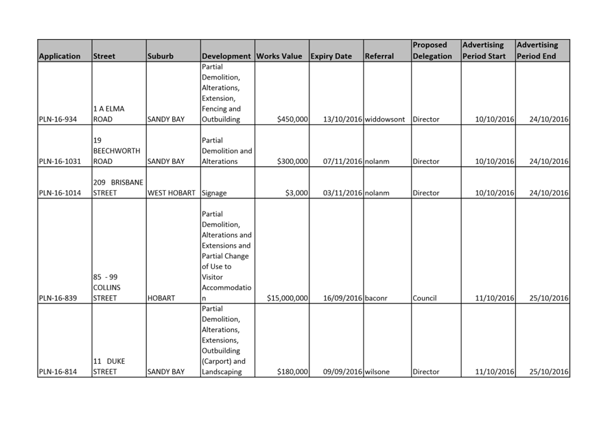
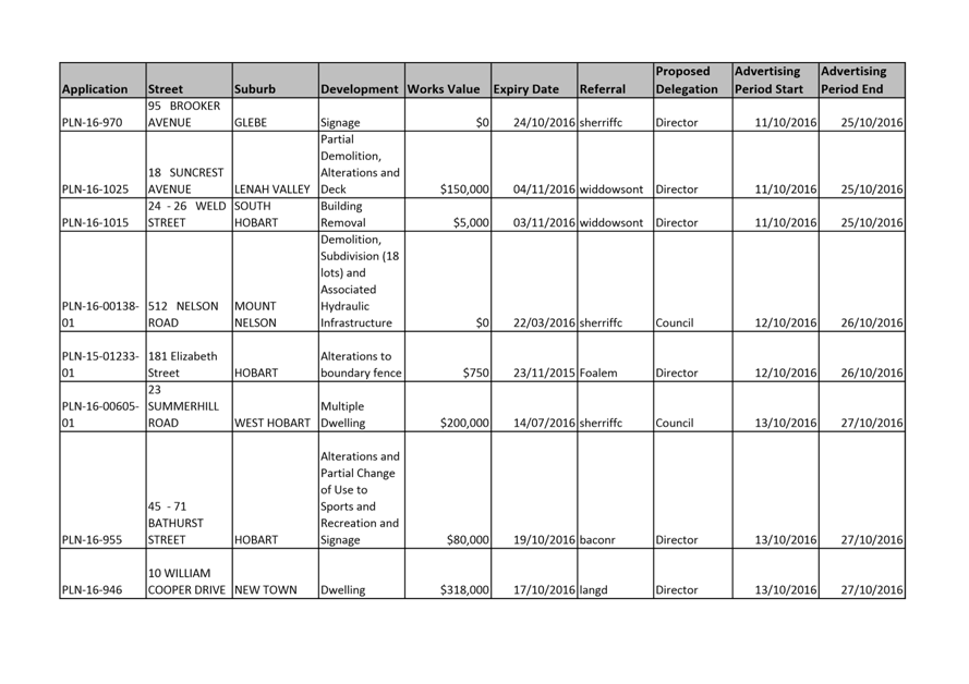
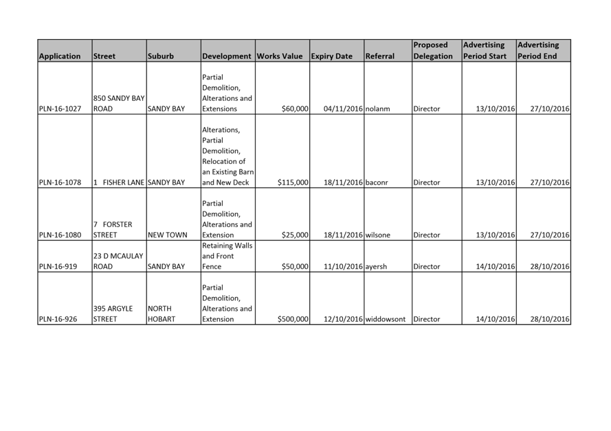
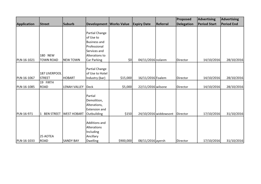
8.2 City Planning - Advertising List
File Ref: F16/121445
Report of the Director City Planning of 25 October 2016 and attachments.
Delegation: Committee
|
Item No. 8.2 |
Agenda (Open Portion) City Planning Committee Meeting |
Page 296 |
|
|
31/10/2016 |
|

Memorandum: City Planning Committee
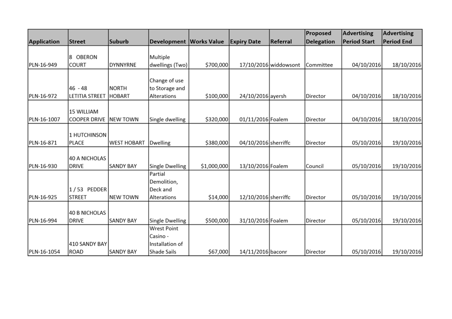
City Planning - Advertising List
Attached is the advertising list for the period 4 October – 17 October 2016
|
That: 1. The information be received and noted.
|
As signatory to this report, I certify that, pursuant to Section 55(1) of the Local Government Act 1993, I hold no interest, as referred to in Section 49 of the Local Government Act 1993, in matters contained in this report.
|
Neil Noye Director City Planning |
|
Date: 25 October 2016
File Reference: F16/121445
Attachment a: City
Planning Advertising 04/10-17/10/2016 ⇩ ![]()
|
Item No. 8.2 |
Agenda (Open Portion) City Planning Committee Meeting - 31/10/2016 |
Page 297 ATTACHMENT a |
|
Agenda (Open Portion) City Planning Committee Meeting |
Page 303 |
|
|
|
31/10/2016 |
|
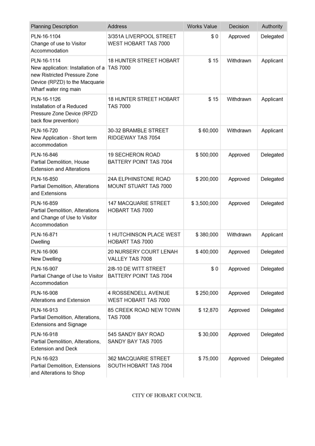
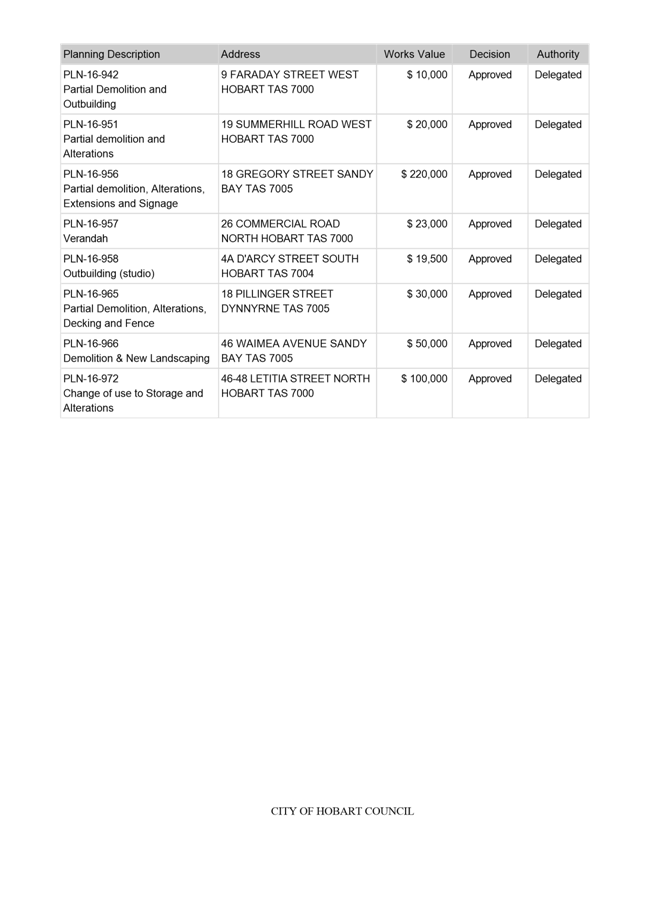
8.3 Delegated Decisions Report (Planning)
File Ref: F16/121448
Report of the Director City Planning of 25 October 2016 and attachments.
Delegation: Committee
|
Item No. 8.3 |
Agenda (Open Portion) City Planning Committee Meeting |
Page 304 |
|
|
31/10/2016 |
|
Memorandum: City Planning Committee
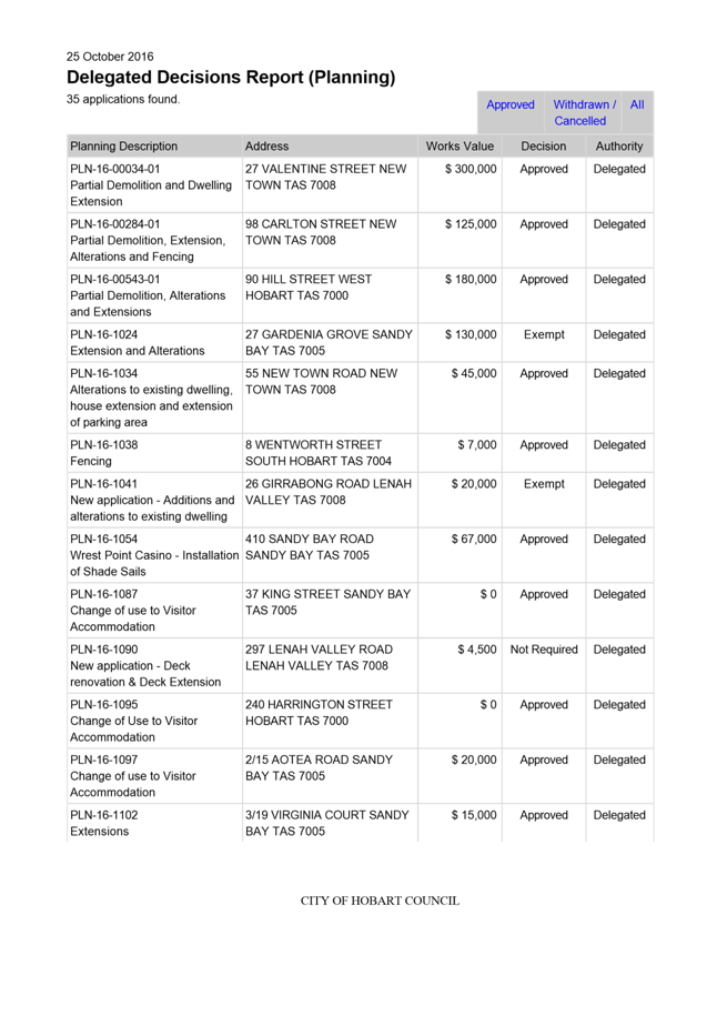
Delegated Decisions Report (Planning)
Attached is the delegated planning decisions report for the period 11 October until 25 October 2016
|
That: 1. The information be received and noted.
|
As signatory to this report, I certify that, pursuant to Section 55(1) of the Local Government Act 1993, I hold no interest, as referred to in Section 49 of the Local Government Act 1993, in matters contained in this report.
|
Neil Noye Director City Planning |
|
Date: 25 October 2016
File Reference: F16/121448
Attachment a: Delegated
Decisions Report 11-25.10.2016 ⇩ ![]()
|
Item No. 8.3 |
Agenda (Open Portion) City Planning Committee Meeting - 31/10/2016 |
Page 305 ATTACHMENT a |
|
Agenda (Open Portion) City Planning Committee Meeting |
Page 308 |
|
|
|
31/10/2016 |
|
8.4 Applications approved under the Building Regulations 2014 and the Building Act 2000
File Ref: F16/122099
Report of the Director City Planning of 25 October 2016 and attachments.
Delegation: Committee
|
Item No. 8.4 |
Agenda (Open Portion) City Planning Committee Meeting |
Page 309 |
|
|
31/10/2016 |
|
Memorandum: City Planning Committee
Applications approved under the Building Regulations 2014 and the Building Act 2000
Attached is the application approved under the Building Regulations 2014 and Building Act 2000.
|
That: 1. The information be received and noted.
|
As signatory to this report, I certify that, pursuant to Section 55(1) of the Local Government Act 1993, I hold no interest, as referred to in Section 49 of the Local Government Act 1993, in matters contained in this report.
|
Neil Noye Director City Planning |
|
Date: 25 October 2016
File Reference: F16/122099
Attachment a: Building
Approvals Comparisons September 2015/September 2016 ⇩ ![]()
Attachment
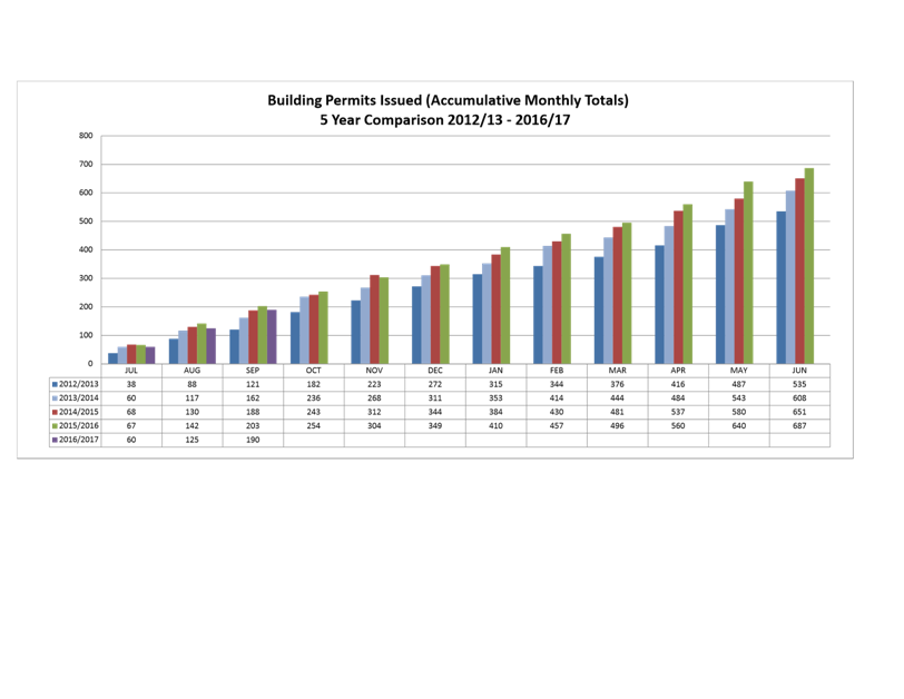
b: Accumulative
Monthly Totals - Building Permit Issued ⇩ ![]()
Attachment
c: Accumulative
Monthly Totals - Building Permits Value ⇩ ![]()
|
Item No. 8.4 |
Agenda (Open Portion) City Planning Committee Meeting - 31/10/2016 |
Page 310 ATTACHMENT a |
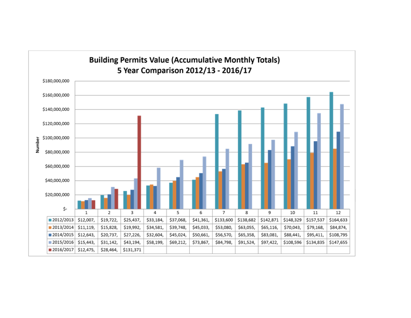
The Director City Planning submits the following information in relation to plans approved under the Building Regulations 2014 and Building Act 2000 together with the attached graphs.
The Director City Planning reports:
A. 1. During the period 1 September 2016 to 30 September 2016, 65 permits were issued to the value of $102,907,050 which included:
(i) 44 for extensions/alterations to dwellings to the value of $6,124,253;
(ii) 8 new dwellings to the value of $3,604,000; and
(iii) 4 major projects:
· 99 Bathurst Street - Office Fitout - $1,100,000
· 2 Churchill Avenue - Alterations and Extensions - $1,900,000
· 48 Liverpool Street (RHH) - Demolition - $6,400,000
· 55-59 Murray Street - ICON Commercial Development - $85,000,000
2. During the period 1 September 2015 to 30 September 2015, 61 permits were issued to the value of $12,052,483 which included:
(i) 37 extensions/alterations to dwellings to the value of $3,327,744
(ii) 7 new dwellings to the value of $2,127,339; and
(iii) 2 major projects:
· 71 Nelson Road - Partial Demolition, Alterations and Extension - $1,100,000
· 48 Liverpool Street, Royal Hobart Hospital, Women’s and Children’s Precinct - Royal Hobart Hospital Services Diversion - $2,300,000
B. 1. In the twelve months ending September 2015, 666 permits were issued to the value of $124,763,730; and
2. In the twelve months ending September 2016, 674 permits were issued to the value of $248,307,414.
|
Agenda (Open Portion) City Planning Committee Meeting - 31/10/2016 |
Page 311 ATTACHMENT b |
|
Agenda (Open Portion) City Planning Committee Meeting - 31/10/2016 |
Page 312 ATTACHMENT c |
|
|
Agenda (Open Portion) City Planning Committee Meeting |
Page 314 |
|
|
31/10/2016 |
|
Section 29 of the Local Government (Meeting Procedures) Regulations 2015.
File Ref: 13-1-10
An Alderman may ask a question without notice of the Chairman, another Alderman, the General Manager or the General Manager’s representative, in line with the following procedures:
1. The Chairman will refuse to accept a question without notice if it does not relate to the Terms of Reference of the Council committee at which it is asked.
2. In putting a question without notice, an Alderman must not:
(i) offer an argument or opinion; or
(ii) draw any inferences or make any imputations – except so far as may be necessary to explain the question.
3. The Chairman must not permit any debate of a question without notice or its answer.
4. The Chairman, Aldermen, General Manager or General Manager’s representative who is asked a question may decline to answer the question, if in the opinion of the respondent it is considered inappropriate due to its being unclear, insulting or improper.
5. The Chairman may require a question to be put in writing.
6. Where a question without notice is asked and answered at a meeting, both the question and the response will be recorded in the minutes of that meeting.
7. Where a response is not able to be provided at the meeting, the question will be taken on notice and
(i) the minutes of the meeting at which the question is asked will record the question and the fact that it has been taken on notice.
(ii) a written response will be provided to all Aldermen, at the appropriate time.
(iii) upon the answer to the question being circulated to Aldermen, both the question and the answer will be listed on the agenda for the next available ordinary meeting of the committee at which it was asked, where it will be listed for noting purposes only.
|
|
Agenda (Open Portion) City Planning Committee Meeting |
Page 315 |
|
|
31/10/2016 |
|