City
of hobart
AGENDA
City Infrastructure Committee Meeting
Open Portion
Wednesday, 26 October 2016
at 5:00 pm
Lady Osborne Room, Town Hall
City
of hobart
AGENDA
City Infrastructure Committee Meeting
Open Portion
Wednesday, 26 October 2016
at 5:00 pm
Lady Osborne Room, Town Hall
THE MISSION
Our mission is to ensure good governance of our capital City.
THE VALUES
The Council is:
|
about people |
We value people – our community, our customers and colleagues. |
|
professional |
We take pride in our work. |
|
enterprising |
We look for ways to create value. |
|
responsive |
We’re accessible and focused on service. |
|
inclusive |
We respect diversity in people and ideas. |
|
making a difference |
We recognise that everything we do shapes Hobart’s future. |
|
|
Agenda (Open Portion) City Infrastructure Committee Meeting |
Page 3 |
|
|
26/10/2016 |
|
Business listed on the agenda is to be conducted in the order in which it is set out, unless the committee by simple majority determines otherwise.
APOLOGIES AND LEAVE OF ABSENCE
1. Co-Option of a Committee Member in the event of a vacancy
3. Consideration of Supplementary Items
4. Indications of Pecuniary and Conflicts of Interest.
6.1 Amendments to the Municipal Map
6.3 Sandy Bay Road Walking and Cycling Project - Safety and Uptake
6.4 Hobart Bicycle Advisory Committee Meeting Notes
6.5 Greenhouse Gas Emissions and Energy Use - 2015-2016 Annual Report
7 Committee Action Status Report
7.1 Committee Actions - Status Report
8. Responses to Questions Without Notice
8.1 Utilisation of Bus Shelter in Macquarie Street
10. Closed Portion Of The Meeting
|
|
Agenda (Open Portion) City Infrastructure Committee Meeting |
Page 4 |
|
|
26/10/2016 |
|
City Infrastructure Committee Meeting (Open Portion) held Wednesday, 26 October 2016 at 5:00 pm in the Lady Osborne Room, Town Hall.
|
COMMITTEE MEMBERS Burnet (Chairman) Deputy Lord Mayor Christie Reynolds Denison Harvey
ALDERMEN Lord Mayor Hickey Zucco Briscoe Ruzicka Sexton Cocker Thomas
|
Apologies:
Leave of Absence: Nil.
|
|
The minutes of the Open Portion of the City Infrastructure Committee meeting held on Wednesday, 21 September 2016, are submitted for confirming as an accurate record.
|
Ref: Part 2, Regulation 8(6) of the Local Government (Meeting Procedures) Regulations 2015.
|
That the Committee resolve to deal with any supplementary items not appearing on the agenda, as reported by the General Manager.
|
Ref: Part 2, Regulation 8(7) of the Local Government (Meeting Procedures) Regulations 2015.
Aldermen are requested to indicate where they may have any pecuniary or conflict of interest in respect to any matter appearing on the agenda, or any supplementary item to the agenda, which the committee has resolved to deal with.
Regulation 15 of the Local Government (Meeting Procedures) Regulations 2015.
A committee may close a part of a meeting to the public where a matter to be discussed falls within 15(2) of the above regulations.
In the event that the committee transfer an item to the closed portion, the reasons for doing so should be stated.
Are there any items which should be transferred from this agenda to the closed portion of the agenda, or from the closed to the open portion of the agenda?
|
Agenda (Open Portion) City Infrastructure Committee Meeting |
Page 6 |
|
|
|
26/10/2016 |
|
6.1 Amendments to the Municipal Map
File Ref: F16/113154
Report of the Manager Road and Environmental Engineering and the Director City Infrastructure of 18 October 2016 and attachments.
Delegation: Council
|
Item No. 6.1 |
Agenda (Open Portion) City Infrastructure Committee Meeting |
Page 7 |
|
|
26/10/2016 |
|
REPORT TITLE: Amendments to the Municipal Map
REPORT PROVIDED BY: Manager Road and Environmental Engineering
Director City Infrastructure
1. Report Purpose and Community Benefit
1.1. The Council’s Municipal Map requires minor amendments to ensure that the record of Council’s statutory road maintenance responsibilities is kept up to date.
1.2. This report seeks Council’s approval to amend the Municipal Map for this purpose.
2. Report Summary
2.1. It is proposed to amend the Municipal Map to include as road reservation or change the road classification of the following parcels of land:
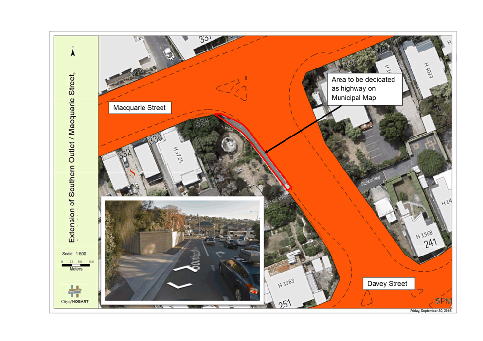
2.1.1. Southern Outlet / Macquarie Street, South Hobart to include the existing footpath on the western side of road.
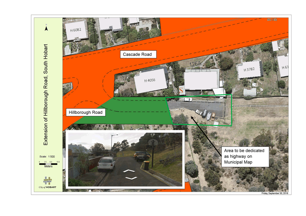
2.1.2. Hillborough Road, South Hobart to include the sealed road within Wellesley Park which provides driveway access to properties on Cascade Road.
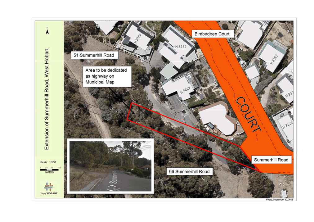
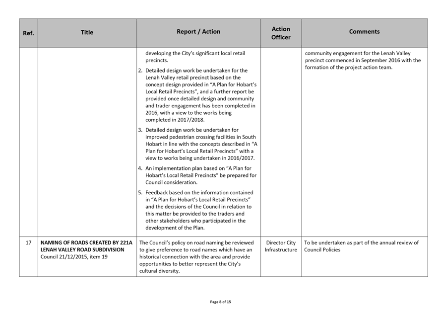
2.1.3. Summerhill Road, West Hobart to extend from Bimbadeen Court to the extent of the current Crown licence to 51 Summerhill Road.
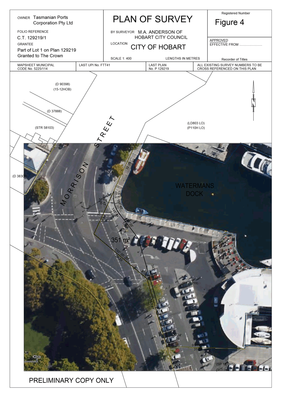
2.1.4. Morrison Street and Castray Esplanade, Battery Point to be included following the transfer of three lots of land from TasPorts to the Council.
2.1.5. Reclassification of a portion of Castray Esplanade, Battery Point outside property 13-17 Castray Esplanade and the CSIRO, opposite 19-21 Castray Esplanade to reflect the current standard of road and footpath.
2.1.6. Reclassification of a portion of Montagu Street, Mount Stuart following the road being upgraded as a result of development at 3B Montagu Street.
|
That: 1. The Council approve the following amendments to the Council’s Municipal Map:
2. A copy of the Council’s resolution be published in the Tasmanian Government Gazette.
|
4. Background
4.1. Section 208 of the Local Government Act 1993 states that:
“A council is to keep up to date a map of its municipal area showing the following:-
(a) All local highways maintainable by it.
(b) All other highways, other than State highways, made, formed, paved or otherwise made good.
(c) All roads known to it that an owner is liable to maintain.”
4.2. Presently a Municipal Map exists which identifies all local roads that are public highways. The Municipal Map reflects the basic construction standard of each road by categorising them into different classes:
4.2.1. Roads that the Council is required to maintain – these are constructed roads such as Regent Street, Sandy Bay.
4.2.2. Roads that the adjoining landowners are liable to maintain – these are unconstructed roads that adjoining owners are legally liable to maintain and construct, but are considered public roads. Usually these roads are not sealed and they do not have kerb and gutter or footpaths, such as Avon Road, South Hobart. Whilst the Council is not legally responsible for the maintenance of these roads, the Council maintains most unconstructed gravel roads with a regular grading program as a service to the community.
4.3. The classification of road is important to the Council, landowners and prospective landowners as it defines who is legally responsible for a road’s maintenance and construction.
4.4. During the conveyancing process, road classification information is provided in Council land information certificates, issued pursuant to S337of the Local Government Act 1993, commonly referred to as Section 337 certificates.
4.5. Currently there are some anomalies within the Municipal Map which can cause uncertainty to those obtaining a Section 337 certificate. This can result in officers spending time investigating the matter and potential purchasers may be unsure whether to proceed or not with the acquisition of property. These anomalies typically include roads that are being maintained by the Council but are not classed as such on the Municipal Map. Updating of the Map may also be required due to a road being upgraded or modified.
4.6. These irregularities can be corrected by the Council amending the Municipal Map, which is the purpose of this report.
4.7. The following amendments are proposed to the Municipal Map:
4.7.1. Extension of Southern Outlet / Macquarie Street, South Hobart to include existing footpath on western side of road.
4.7.2. Extension of Hillborough Road, South Hobart to include sealed road within Hobart City Council reserve which provides driveway access to properties on Cascade Road.
4.7.3. Extension of Summerhill Road, West Hobart from Bimbadeen Court to the extent of Crown licence to 51 Summerhill Road, including existing driveway entrances and section to be upgraded as part of a proposed subdivision development at 66 Summerhill Road.
4.7.4. Extension of Morrison Street and Castray Esplanade, Battery Point resulting from TasPorts to Hobart City Council land transfer of three lots.
4.7.5. Change in classification of Castray Esplanade, Battery Point outside 13-17 Castray Esplanade and CSIRO opposite 19-21 Castray Esplanade to reflect the current standard of road and footpath.
4.7.6. Change of classification of a section of Montagu Street, Mount Stuart due to the road being upgraded by development at 3B Montagu Street.
5. Proposal and Implementation
5.1. It is proposed to update the Municipal Map to reflect the status of a number of roads which Council currently maintains or provides driveway access to properties.
5.2. The locations of the roads proposed to be included in the Municipal Map are shown in Attachments A to G. All distances are approximate and subject to final survey.
5.3. The proposed amendments to the Municipal Map are detailed below.
5.4. Extension of Southern Outlet / Macquarie Street, South Hobart to include existing footpath on western side of road, as shown in Attachment A.
5.4.1. The constructed sealed footpath is on Council land located on the western side of the Southern Outlet at the intersection with Macquarie Street.
5.4.2. It is proposed that this road be classified as a constructed road on the Municipal Map.
5.5. Extension of Hillborough Road, South Hobart to include the sealed road within Wellesley Park which provides driveway access to properties on Cascade Road, as shown in Attachment B.
5.5.1. The carriageway has operated as a public highway and dedicating it as such will enable the regulation of the driveway access into properties and parking.
5.5.2. It is proposed that this road be classified as a constructed road (carriageway only) on the Municipal Map.
5.6. Extension of Summerhill Road, West Hobart from Bimbadeen Court to the extent of an existing Crown licence to 51 Summerhill Road, including existing driveway entrances and a section to be upgraded as part of a proposed subdivision development at 66 Summerhill Road, as shown in Attachment C.
5.6.1. The Crown currently issues a licence to the owners of 51 Summerhill Road to provide vehicle access to the property. This property does not have a frontage to a highway reservation and is land locked. A planning application is underway for this property, but the inclusion of this land on the Municipal Map as an unconstructed road will have no impact on the planning application process.
5.6.2. The owner of 66 Summerhill Road is proposing to subdivide and extend the public highway over a portion of the Crown land to gain access to that property. The developer has approached the Council to include this parcel of land on the Municipal Map. This proposed subdivision and any subsequent development will be subject to planning approval.
5.6.3. Dedicating this land as unconstructed highway reservation would mean that 51 Summerhill Road would have access to a public road and would also allow access to the proposed subdivision of 66 Summerhill Road.
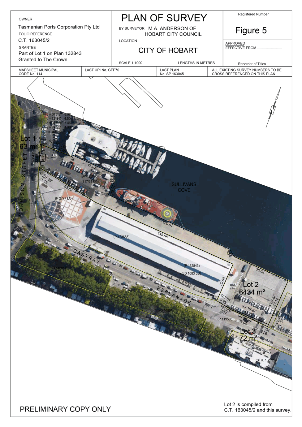
5.7. Extension of Morrison Street and Castray Esplanade, Battery Point resulting from TasPorts land transfer to Hobart City Council of three lots, as shown in Attachment D and E.
5.7.1. On 15 December 2014, the Council resolved to negotiate with TasPorts for the transfer of three lots of land adjacent to Castray Esplanade and Morrison Street and for the land be dedicated as public highway.
5.7.2. The lots are as follows:
5.7.2.1. Lot 3 on Folio Reference CT 163045/2 located at “The Paddock” Castray Esplanade which is situated between the Princes Wharf 1 (PW1) building and the new UTAS IMAS building adjacent to Castray Esplanade.
5.7.2.2. Lot 1 on Folio Reference CT 163045/2 located in the vicinity of the exit of the car park between Watermans Dock and the PW1 forecourt. Some of this lot is an extension of the highway reservation and the other part is a change to the classification on the Municipal Map from an unconstructed road to fully constructed road.
5.7.2.3. Lot 1 on Folio Reference CT 129219/1 located in the vicinity of the entrance to the car park between Watermans Dock and the PW1 forecourt.
5.7.3. The documentation for the transfer of the land has been lodged with the Land Titles Office and the dedication of the lots as highway reservation will align with the works being undertaken along Morrison Street and existing public pedestrian use of the area.
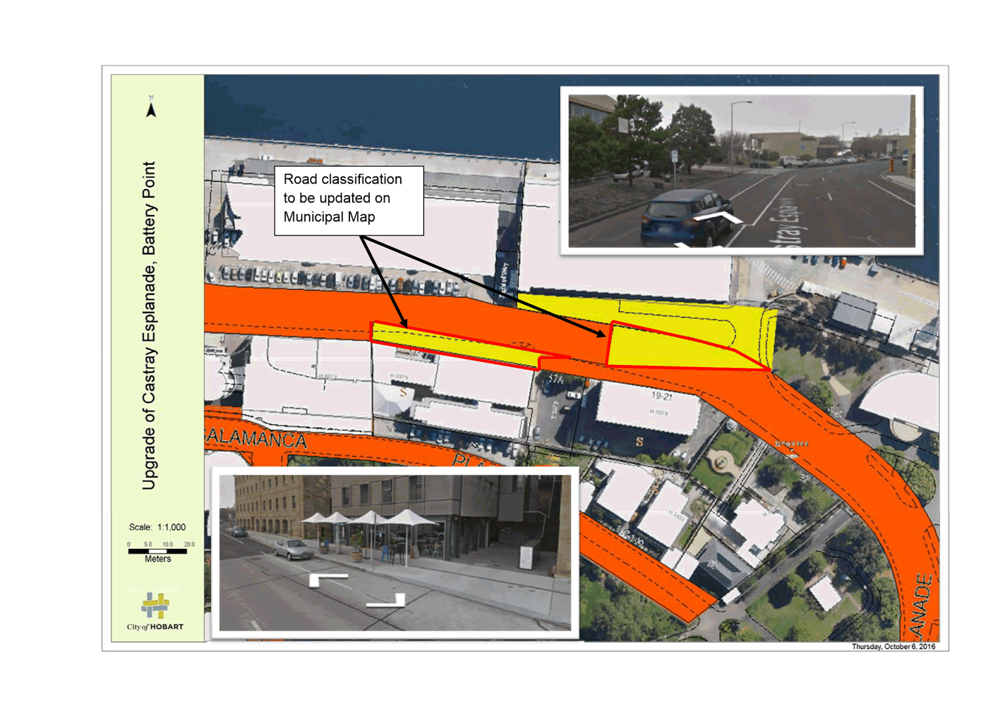
5.8. The reclassification to constructed road of a section of Castray Esplanade, Battery Point outside 13-17 Castray Esplanade and CSIRO opposite 19-21 Castray Esplanade to reflect the current standard of road and footpath, as shown in Attachment F.
5.8.1. Outside 13-17 Castray Esplanade, there is a footpath and kerb and opposite 19-21 Castray Esplanade there is existing road pavement and kerb which are to a fully constructed road standard.
5.8.2. It is proposed that this section of road be classified as a constructed road on the Municipal Map.
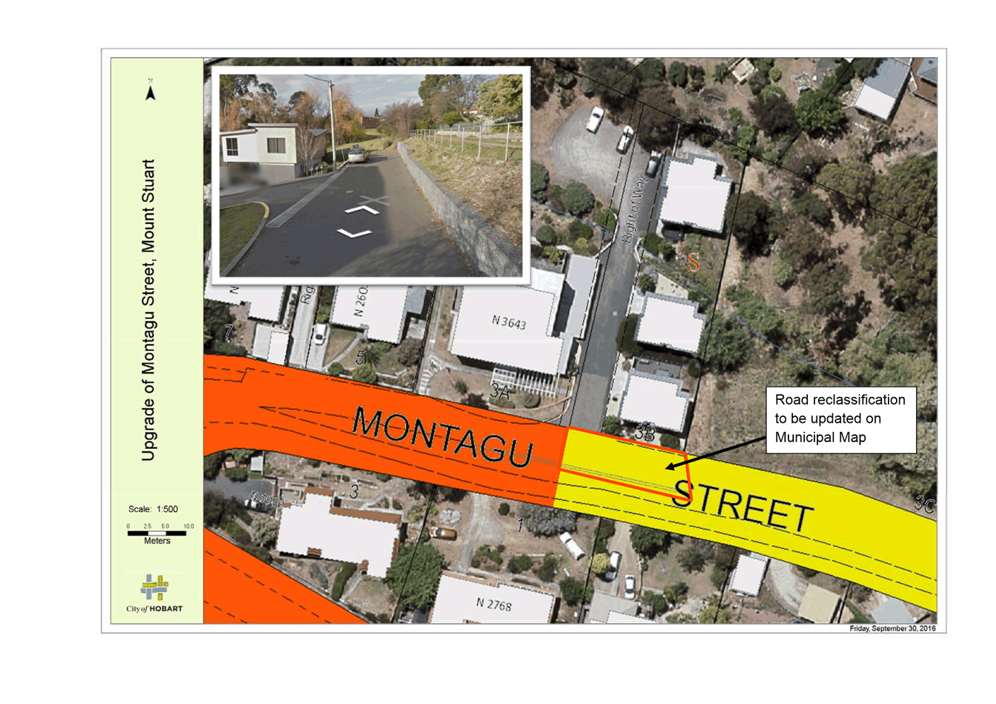
5.9. The reclassification to constructed road of a section of Montagu Street, Mount Stuart due to the road being upgraded as a result of development at 3B Montagu Street, as shown in Attachment G.
5.9.1. The constructed sealed carriageway and retaining wall was installed as part of the development at 3B Montagu Street. The section is currently classified as an unconstructed road on the Municipal Map and it is proposed that the classification be amended to constructed road to reflect the work that has been undertaken.
5.10. Following the Council’s decision the Municipal Map would be updated and a copy of the resolution would be published in the Tasmanian Government Gazette.
6. Strategic Planning and Policy Considerations
6.1. Goal 2 – Urban Management from the Capital City Strategic Plan is relevant in considering this report, specifically strategic objective 2.2.2 Develop, manage and maintain the city’s urban spaces and infrastructure.
7. Financial Implications
7.1. Funding Source and Impact on Current Year Operating Result
7.1.1. Not applicable
7.2. Impact on Future Years’ Financial Result
7.2.1. Not applicable
7.3. Asset Related Implications
7.3.1. The parcels of land for inclusion or change of classification on the Municipal Map are currently maintained by Hobart City Council, apart from the proposed extension of the Summerhill Road highway reservation.
7.3.1.1. This land has no Council assets on it, thus will not affect Hobart City Council’s current maintenance program.
7.3.2. Apart from the extension of Summerhill Road, the majority of the parcels of land for inclusion or classification upgrade on the Municipal Map are already included in the Council’s road asset register. The assets that are not listed will marginally impact the annual depreciation, with the amount expected to be less than $5,000 per year.
8. Legal, Risk and Legislative Considerations
8.1. Section 12 of the Local Government (Highways) Act 1982 states that:
“A corporation may, by resolution of the council, declare that a road or other way within the municipality that is not a highway shall become, as specified in the resolution, a highway maintainable by the corporation or a particular kind of highway so maintainable.
The corporation shall cause a copy of a resolution under this section to be published in the Gazette and the road or other way to which the resolution relates becomes, on the date of the publication, such a highway as is specified in the resolution.”
8.2. Roads which are specified on the Municipal Map can then be managed in accordance with the Local Government (Highways) Act 1982 and the Council’s Highways By-law.
9. Community and Stakeholder Engagement
9.1. The footpath on the western side of the Southern Outlet / Macquarie Street is currently managed and owned by Hobart City Council and as such no consultation is required.
9.2. The City’s Park Planner has been consulted regarding the inclusion of the end of Hillborough Road on the Municipal Map which is currently part of the Wellesley Park reserve. The proposal is supported as it will assist in addressing current private driveway and parking issues.
9.3. An officer of Crown Land Services has been consulted and has no objections regarding the inclusion of Summerhill Road from Bimbadeen Court to the extent of the current Crown licence to 51 Summerhill Road.
9.4. The owners of 51 Summerhill Road have been informed of the proposed dedication of the land on the Municipal Map which will mean that their property would have frontage to and be accessible from a public road.
9.5. The developer of 66 Summerhill Road has requested that a portion of the Crown land be dedicated as highway reservation on the Municipal Map to enable a proposed subdivision to occur which would include the construction of a road that would handed over to Council as part of the development.
9.6. The Crown, the developer of 66 Summerhill Road and the owners of 51 Summerhill Road would be informed of Council’s decision regarding this proposal.
9.7. TasPorts has been consulted and are supportive the three lots alongside Morrison Street and Castray Esplanade being placed on the Municipal Map.
9.8. Consultation regarding the upgrade of the status of the highway outside 13-17 Castray Esplanade and CSIRO, opposite 19-21 Castray Esplanade from unconstructed road to fully constructed road, is not required as there is either no owner associated with the title or it is shown as road on the sealed plan.
9.9. The upgrade of Montagu Street adjacent to 3B Montagu Street is currently classified on the Municipal Map as an unconstructed road. Consultation to change its status to a fully constructed road is not required as this was the intention when the road was upgraded as part of the development of 3B Montagu Street.
10. Delegation
10.1. This matter is delegated to the Council.
As signatory to this report, I certify that, pursuant to Section 55(1) of the Local Government Act 1993, I hold no interest, as referred to in Section 49 of the Local Government Act 1993, in matters contained in this report.
|
John Holmes Manager Road and Environmental Engineering |
Mark Painter Director City Infrastructure |
Date: 18 October 2016
File Reference: F16/113154
Attachment a: Extension
of Southern Outlet / Macquarie Street ⇩ ![]()
Attachment
b: Extension
of Hillborough Road, South Hobart ⇩ ![]()
Attachment
c: Extension
of Summerhill Road, West Hobart ⇩ ![]()
Attachment
d: Plan
of Survey-Morrison Street/Castray Esplanade-TasPorts 1
⇩ ![]()
Attachment
e: Plan
of Survey-Morrison Street/Castray Esplanade-TasPorts 2
⇩ ![]()
Attachment
f: Upgrade
of Castray Esplanade, Battery Point ⇩ ![]()
Attachment
g: Upgrade
of Montagu Street, Mount Stuart ⇩ ![]()
|
Item No. 6.1 |
Agenda (Open Portion) City Infrastructure Committee Meeting - 26/10/2016 |
Page 15 ATTACHMENT a |
|
Agenda (Open Portion) City Infrastructure Committee Meeting - 26/10/2016 |
Page 17 ATTACHMENT b |
|
Agenda (Open Portion) City Infrastructure Committee Meeting - 26/10/2016 |
Page 19 ATTACHMENT c |
|
Agenda (Open Portion) City Infrastructure Committee Meeting - 26/10/2016 |
Page 21 ATTACHMENT d |
|
Agenda (Open Portion) City Infrastructure Committee Meeting - 26/10/2016 |
Page 22 ATTACHMENT e |
|
Agenda (Open Portion) City Infrastructure Committee Meeting - 26/10/2016 |
Page 23 ATTACHMENT f |
|
Agenda (Open Portion) City Infrastructure Committee Meeting - 26/10/2016 |
Page 25 ATTACHMENT g |
|
Agenda (Open Portion) City Infrastructure Committee Meeting |
Page 27 |
|
|
|
26/10/2016 |
|
6.2 Port of Hobart - Export of Timber Products - Potential Impact on Macquarie and Davey Streets, Hobart
File Ref: F16/116164
Report of the Manager Traffic Engineering and the Director City Infrastructure of 18 October 2016 and attachment.
Delegation: Council
|
Item No. 6.2 |
Agenda (Open Portion) City Infrastructure Committee Meeting |
Page 28 |
|
|
26/10/2016 |
|
REPORT TITLE: Port of Hobart - Export of Timber Products - Potential Impact on Macquarie and Davey Streets, Hobart
REPORT PROVIDED BY: Manager Traffic Engineering
Director City Infrastructure
1. Report Purpose and Community Benefit
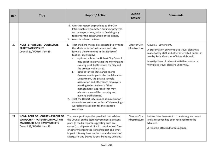
1.1. This report responds to a Notice of Motion from the Council meeting of 23 May 2016, that “an urgent report be provided that advises the Council on the State Government’s present plans [if media reports suggesting such are correct] to ship woodchips in containerised form or otherwise from the Port of Hobart and what impact this may have on the use and amenity of Macquarie and Davey Streets, Hobart by heavy vehicles”.
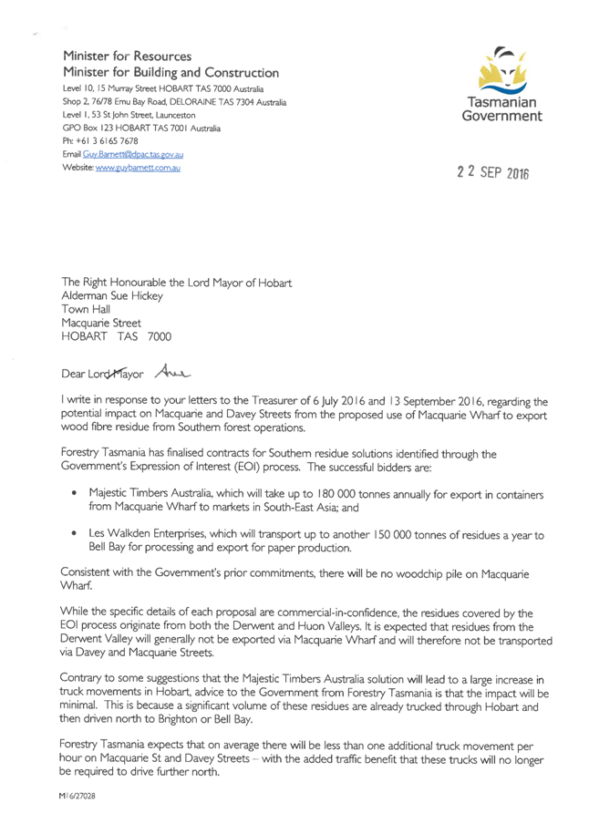
1.2. Advice has been provided by the Minister for Resources confirming that the Port will be used for the transportation of forest residues and that Forestry Tasmania expects the impact on Davey and Macquarie Streets will be minimal. The letter of advice is provided as Attachment A to this report.
1.3. There is a benefit to the community in understanding the impacts of this change on the traffic network.
2. Report Summary
2.1. The Lord Mayor wrote to the State Government seeking the information requested in the Notice of Motion.
2.2. The response from the Minister for Resources, Guy Barnett MP, confirmed that the State Government does intend to use the Port of Hobart for the export of wood fibre residues and expects that the average number of large truck movements on Macquarie and Davey Streets would increase by approximately one truck movement per hour.
2.2.1. This figure is an average and it is unlikely that the resultant truck movements would be spread evenly throughout the day or year.
2.3. Davey and Macquarie Streets are both classified as arterial roads and are included on the existing heavy vehicle route network and will be able to absorb the additional truck movements with minimal impact on either the traffic network or the physical structure of the roads.
2.3.1. Additionally because of the status of Macquarie and Davey Streets being arterial roads and on the heavy vehicle route network, it is preferable that these truck movement occur on these roads rather than any others in the city.
|
That the letter from the Minister for Resources dated 22 September 2016 regarding the use of the Port of Hobart for the export of woodfibre residues and the resultant impact on Macquarie Street and Davey Street, Hobart, be received and noted. |
4. Background
4.1. At the Council meeting of 23 May 2016, Alderman Thomas presented a Notice of Motion that “an urgent report be provided that advises the Council on the State Government’s present plans [if media reports suggesting such are correct] to ship woodchips in containerised form or otherwise from the Port of Hobart and what impact this may have on the use and amenity of Macquarie and Davey Streets by heavy vehicles”.
4.2. The Lord Mayor subsequently wrote to the State Government seeking advice and a response was provided by the Minister for Resources, Guy Barnett MP on 22 September 2016. That letter is provided as Attachment A to this report.
4.3. The letter states that wood fibre residues produced in the Huon Valley will be exported from the Port of Hobart (and as such, the trucks will need to travel on Davey and Macquarie Streets) while material produced in the Derwent Valley is not expected to be exported via the Port.
4.4. Additionally the letter states that Davey and Macquarie Streets are already used by heavy vehicles to transport wood fibre residues to Bell Bay and that the recently finalised Forestry Tasmania contracts are expected to generate an average of one additional truck movement per hour on Macquarie and Davey Streets.
4.4.1. The figure of one additional truck movement per hours is an average and it is unlikely that the resultant truck movements would be spread evenly throughout the day or year.
4.5. Macquarie and Davey Streets are both classified as arterial roads and are included on the existing heavy vehicle route and as such will be able to absorb the expected additional truck movements with minimal impact on either the traffic network or the physical structure of the roads.
4.5.1. Additionally because of the status of Macquarie and Davey Streets being arterial roads and on the heavy vehicle route, it is preferable that these truck movements occur on these roads rather than any others in the city.
5. Proposal and Implementation
5.1. It is proposed that the letter from the Minister for Resources be noted.
6. Strategic Planning and Policy Considerations
6.1. Goal 2 – Urban Management from the Capital City Strategic Plan 2015-2025 is relevant in considering this matter.
7. Financial Implications
7.1. Funding Source and Impact on Current Year Operating Result
7.1.1. Not applicable.
8. Legal, Risk and Legislative Considerations
8.1. The Council has no power to prevent the use of Macquarie and Davey Streets by heavy vehicles transporting wood fibre products to the Port of Hobart for export.
9. Delegation
9.1. This matter is delegated to the Council.
As signatory to this report, I certify that, pursuant to Section 55(1) of the Local Government Act 1993, I hold no interest, as referred to in Section 49 of the Local Government Act 1993, in matters contained in this report.
|
Angela Moore Manager Traffic Engineering |
Mark Painter Director City Infrastructure |
Date: 18 October 2016
File Reference: F16/116164
Attachment a: Response
to Potential Impact on Macquarie and Davey Streets from the Proposed Use of Macquarie
Wharf to Export Wood Fibre Residue from Southern Forest Operations - Minister
Guy Barnett - 22 September 2016 ⇩ ![]()
|
Item No. 6.2 |
Agenda (Open Portion) City Infrastructure Committee Meeting - 26/10/2016 |
Page 31 ATTACHMENT a |

|
Agenda (Open Portion) City Infrastructure Committee Meeting |
Page 33 |
|
|
|
26/10/2016 |
|
6.3 Sandy Bay Road Walking and Cycling Project - Safety and Uptake
File Ref: F16/91526
Report of the Manager Traffic Engineering and the Director City Infrastructure of 18 October 2016.
Delegation: Committee
|
Item No. 6.3 |
Agenda (Open Portion) City Infrastructure Committee Meeting |
Page 34 |
|
|
26/10/2016 |
|
REPORT TITLE: Sandy Bay Road Walking and Cycling Project - Safety and Uptake
REPORT PROVIDED BY: Manager Traffic Engineering
Director City Infrastructure
1. Report Purpose and Community Benefit
1.1. This report responds to previous Council resolutions regarding the Sandy Bay Road Walking and Cycling Project, specifically providing information regarding usage and uptake.
1.2. There is benefit to the community in continuing to monitor the usage and ongoing safety of all users on Sandy Bay Road, to ensure that any issues can be identified and addressed as required (for both this project and other similar projects into the future).
2. Report Summary
2.1. The Sandy Bay Road Walking and Cycling Project is being implemented progressively with the first two stages now complete and Stage 3 of the project currently under construction.
2.1.1. Stage 1 of the project was completed in February 2014, and saw the installation of on-road bicycle lanes along both sides of Sandy Bay Road between Derwentwater Avenue and Fisher Avenue.
2.1.2. Stage 2 included an off-road shared path along the eastern side of Sandy Bay Road between Marieville Esplanade and Derwentwater Avenue (including a “toucan” crossing at the Drysdale Avenue traffic signals) and was completed in October 2014.
2.1.3. Stage 3 of the project (on Sandy Bay Road between Wayne Avenue and the Kingborough boundary) commenced in February 2016, and is due to be completed before Christmas 2016.
2.2. There has been a steady increase in cycling numbers along Sandy Bay Road since completion of the Stage 1 and Stage 2 sections of the Sandy Bay Walking and Cycling Project.
2.3. The installation of permanent bicycle counters on both Stage 1 and Stage 2 of the project will further assist in assessing the use of the cycling facilities provided by this scheme.
2.4. Crash data has been extracted from the Department of State Growth database for the five year period to 31 March 2016.
2.4.1. In the 12 months to 31 March 2016, there have been seven crashes reported on the Stage 1 section of Sandy Bay Road (between Derwentwater Avenue and Fisher Avenue). There were no crashes reported in the 12 month period that involved a cyclist.
2.4.2. In the year since the completion of Stage 2, there have been four crashes reported on Sandy Bay Road between Marieville Esplanade and Derwentwater Avenue, and none of those crashes involved a cyclist.
2.5. Apart from a slightly elevated crash rate in 2014/2015, there has not been a statistically significant increase or decrease in crashes on either the Stage 1 or Stage 2 section of Sandy Bay Road.
2.6. Monitoring of the cycling uptake and safety relating to the Sandy Bay Road Walking and Cycling project will continue on an ongoing basis and the City’s officers will continue to respond to any safety issues on this (and other roads) as they arise.
|
That the report of the Manager Traffic Engineering and the Director City Infrastructure titled ‘Sandy Bay Road Walking and Cycling Project – Safety and Uptake’ be received and noted. |
4. Background
4.1. Sandy Bay Road between Marieville Esplanade and the southern municipal boundary with Kingborough was identified as part of the Principal Bicycle Network (adopted by Council in 2008) and also in the 2009 Hobart Regional Arterial Bicycle Network Plan. The Sandy Bay Road Walking and Cycling Project delivers cycling infrastructure on this part of the designated arterial bicycle network.
4.2. The Sandy Bay Road Walking and Cycling Project is being implemented progressively with the first two stages now complete and Stage 3 of the project currently under construction.
4.2.1. Stage 1 saw the installation of on-road bicycle lanes along both sides of Sandy Bay Road between Derwentwater Avenue and Fisher Avenue and was completed in February 2014.
The speed limit in this section of Sandy Bay Road was reduced from 60km/h to 50km/h when the stage of the project was completed.
4.2.2. Stage 2 included the completion of an off-road shared path along the eastern side of Sandy Bay Road between Marieville Esplanade and Derwentwater Avenue, including a “toucan” crossing (where both pedestrians and bike riders can cross together) at the Drysdale Avenue traffic signals and was completed in October 2014.
4.2.3. Stage 3 of the project (on Sandy Bay Road between Wayne Avenue and the Kingborough boundary) commenced in February 2016 and is due to be completed before Christmas 2016. This stage also includes a reduction in the posted speed limit, reducing from 60km/h to 50km/h.
4.3. At its meeting of 11 August 2014, the Council resolved that:
1. The installation of an in-bound bicycle counter on Sandy Bay Road be approved, at an estimated cost of $3,000 to be funded from the existing Sustainable Transport budget allocation contained within the Traffic Strategy and Projects Function in the 2014/2015 Annual Plan.
2. The further surveying of users of the Sandy Bay Road, on-road bicycle facilities, be referred to the Hobart Bicycle Advisory Committee for comment.
3. The City of Hobart continue to participate in the Hobart Counts annual commuter bicycle survey, at an estimated cost of $3,750, to be funded from the Sustainable Transport budget allocation within the Traffic Strategy and Projects Function in the 2014/2015 Annual Plan.
4.4. Permanent counter sites have been established. However, one of the sites (in the Stage 2 section) has had faulty loops installed and data collected at this location has not been reliable. As such, no data has been collected from this permanent counter site but it will provide useful data on usage and uptake of cycling into the future. The faulty loops are scheduled to be recut and replaced soon.
4.5. The permanent counter installed just south of Derwentwater Avenue has provided data suggesting that an average of 176 cyclists per day travel towards the City on the Sandy Bay Road bike lane. There are very similar numbers of cyclists using the road on both weekdays and on weekends.
4.6. The Hobart City Council (as one of the Cycling South member Councils) has been collecting annual data on the number of riders using various routes around Greater Hobart. These counts have been done annually on the first Tuesday in March since 2010 and help monitor trends and growth in cycling. The “Super Tuesday” survey records the number of cyclists at the identified locations for the two hour period between 7:00am and 9:00am.
5. Usage and Uptake
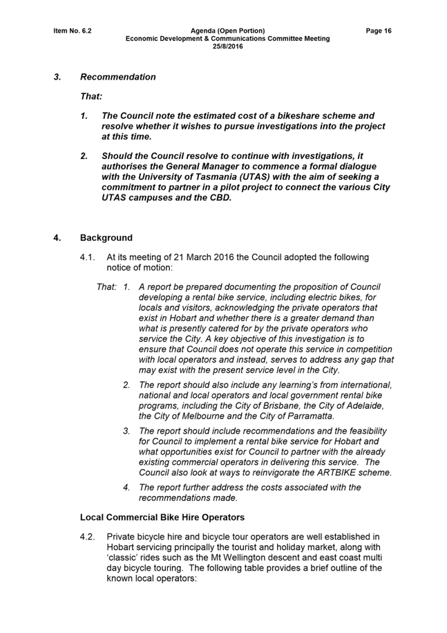
5.1. Figure 1, below, shows the number of cyclists recorded at the intersection of Marieville Esplanade / Earl Street / Sandy Bay Road and also at the intersection of Churchill Avenue / Sandy Bay Road collected during the “Super Tuesday” surveys. It can be seen that at both of the Sandy Bay Road locations there has been a steady increase in cyclists recorded in 2016 compared to the 2015 results (up by approximately 20 cyclists at both locations).
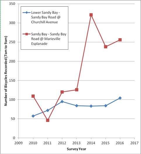
FIGURE 1 – Cycle numbers by site (Super Tuesday Counts), Sandy Bay Road only
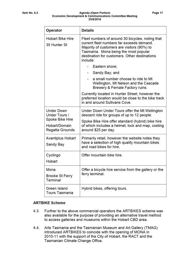
5.2. Figure 2, below, shows a comparison of the Marieville Esplanade / Earl Street / Sandy Bay Road intersection and the Churchill Avenue / Sandy Bay Road intersection, an aggregation of all Sandy Bay sites and all Hobart sites. It can be seen that the steady increase in cycling numbers from 2015 to 2016 is consistent across all sites and not specific to the Sandy Bay Road locations.
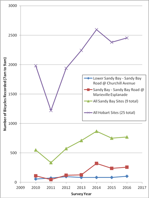
FIGURE 2 – Cycle numbers by site (Super Tuesday Counts), various sites
6. Road Safety Outcomes – Stage 1
6.1. Crash data has been extracted from the Department of State Growth crash database for the five years to 31 March 2016 for the section of Sandy Bay Road between Derwentwater Avenue and Fisher Avenue which represents the section of works completed as Stage 1 of the Sandy Bay Road Walking and Cycling project.
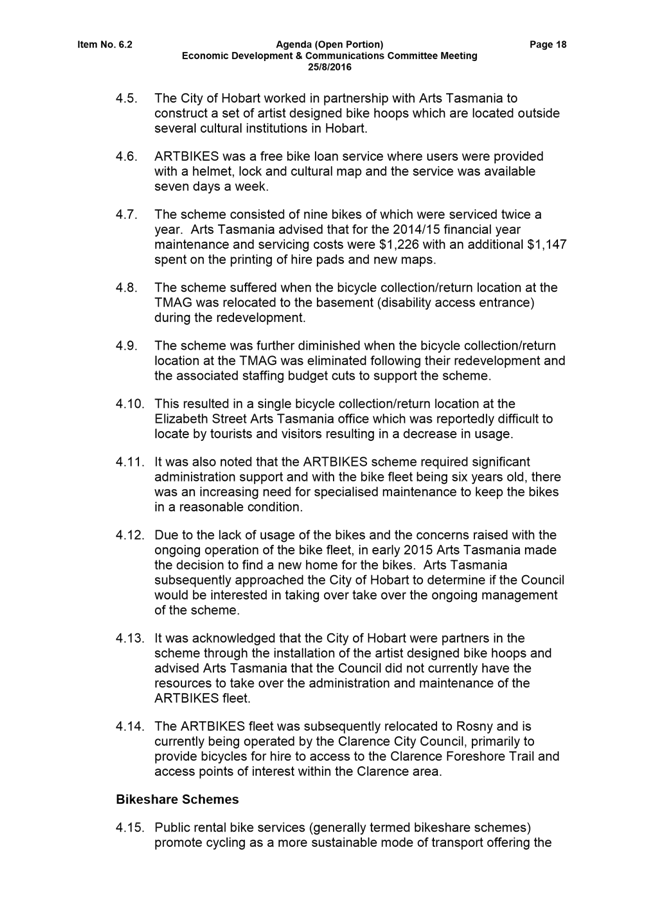
6.2. A
total of 40 crashes were reported over the five year period, with seven crashes
reported in the 12 month period to 31 March 2016 (contributing to a total
of 18 crashes since the completion of the bicycle lanes in this section of
Sandy Bay Road). Figure 3 shows the number of crashes each year,
categorised by severity. The number of crashes reported in the last year is
generally consistent with the number reported in the previous year
(notwithstanding the slightly increased crash rate in
2014-2015). The severity of crashes reported in the last 12 months has
improved, with only one injury crash (first aid) reported and the remaining
crashes being property damage only crashes.
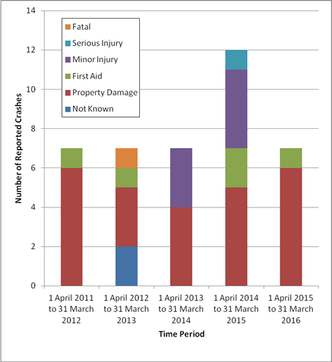
FIGURE 3 – Severity of crashes by year (Cycleway Stage 1)
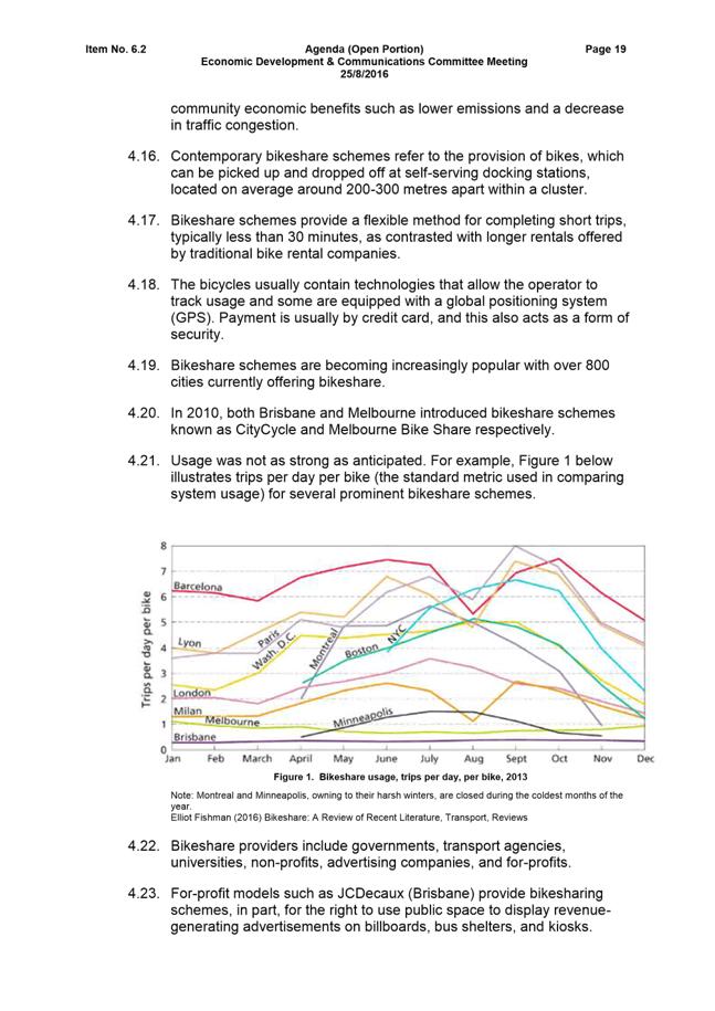
6.3. Figure 4 shows a comparison of the type of vehicle involved in the crashes. The majority of crashes involved light or heavy vehicles only. On average there have been 2.25 crashes involving a vulnerable road user (such as a pedestrian, cyclist or motorcyclist).
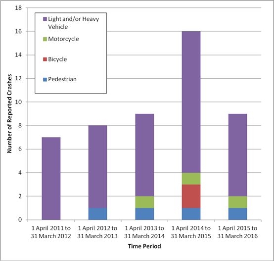
FIGURE 4 – Crashes by vehicle type by year
6.4. In the period 1 April 2015 to 31 March 2016 there was one property damage crash involving a motorcycle, and one pedestrian crash requiring first aid. There were no crashes reported in the 12 month period that involved a cyclist.
7. Road Safety Outcomes – Stage 2
7.1. Crash data has been extracted from the Department of State Growth crash database for the five years to 31 March 2016 for the section of Sandy Bay Road between Marieville Esplanade and Derwentwater Avenue which represents the section of works completed as Stage 2 of the Sandy Bay Road Walking and Cycling project.
7.2. A total of 51 crashes were reported over the five year period. Figure 5 shows the number of crashes recorded each year, categorised by severity.
7.3. It can be seen that reported crashes have decreased in 2015-2016 with four crashes reported, a decrease from the average of 11.75 crashes per year in the previous four years. Three of the four crashes that were reported in the year to 31 March 2016 occurred at the intersection of Sandy Bay Road / Nelson Road / Drysdale Place.
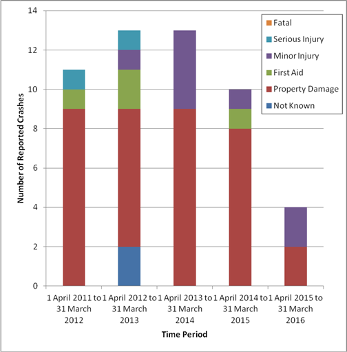
FIGURE 5 – Severity of crashes by year (Cycleway Stage 2)
7.4. Figure 6 shows a comparison of the type of vehicle involved in the crashes. In 2011-2012 and 2015-2016 there were no crashes recorded that involved vulnerable road users.
7.5. There were three pedestrian crashes reported in the 12 months to 31 March 2013 – two of which occurred at the Sandy Bay Road / Nelson Road / Drysdale Place traffic signals and were recorded as requiring first aid at the scene. Three minor injury pedestrian crashes and one property damage only bicycle crash were reported in 2013-2014. One property damage only bicycle crash was also reported in 2014-2015 – this crash did not involve another vehicle.
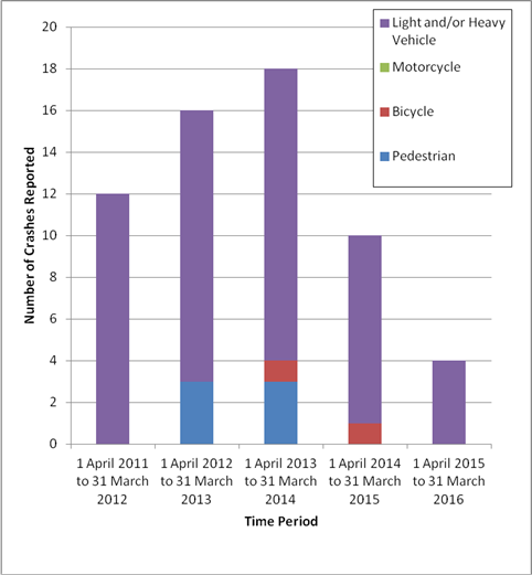
FIGURE 6 –Crashes by vehicle type by year (Cycleway Stage 2)
8. Proposal and Implementation
8.1. That monitoring of the cycling uptake and safety in regard to the Sandy Bay Road Walking and Cycling project continue on an ongoing basis and that the City’s officers continue to respond to any safety issues on this (and other roads) as they arise.
9. Strategic Planning and Policy Considerations
9.1. The following Capital City Strategic Plan 2015-2025 references are relevant in considering this matter:
9.1.1. “Goal 2 - Urban Management” and particularly the following sub-objectives of “Strategic Objective 2.1 – A fully accessible and connected city environment”:
2.1.2 Enhance transport connections within Hobart
2.1.3 Identify and implement infrastructure improvements to enhance road safety
2.1.6 Implement the Principal Bicycle Network
10. Financial Implications
10.1. Funding Source and Impact on Current Year Operating Result
10.1.1. Not applicable.
11. Legal, Risk and Legislative Considerations
11.1. Ongoing monitoring of safety along the length of the Sandy Bay Road Walking and Cycling project will ensure that any trends are identified and issues rectified as necessary. Any issues identified in the early stages of the project can be addressed in future stages and on other cycling projects throughout the City of Hobart.
12. Delegation
12.1. This matter is delegated to the Committee.
As signatory to this report, I certify that, pursuant to Section 55(1) of the Local Government Act 1993, I hold no interest, as referred to in Section 49 of the Local Government Act 1993, in matters contained in this report.
|
Angela Moore Manager Traffic Engineering |
Mark Painter Director City Infrastructure |
Date: 18 October 2016
File Reference: F16/91526
|
Item No. 6.4 |
Agenda (Open Portion) City Infrastructure Committee Meeting |
Page 44 |
|
|
26/10/2016 |
|
6.4 Hobart Bicycle Advisory Committee Meeting Notes
File Ref: F16/117654; 37-1-4
Memorandum of the Director City Infrastructure of 18 October 2016 and attachment.
Delegation: Committee
|
Item No. 6.4 |
Agenda (Open Portion) City Infrastructure Committee Meeting |
Page 45 |
|
|
26/10/2016 |
|

Memorandum: City Infrastructure Committee
Hobart Bicycle Advisory Committee Meeting Notes
The Hobart Bicycle Advisory Committee met on 21 September 2016 and the draft notes from the meeting are attached.
|
That the draft notes of the Hobart Bicycle Advisory Committee meeting held on 21 September 2016 be received and noted.
|
As signatory to this report, I certify that, pursuant to Section 55(1) of the Local Government Act 1993, I hold no interest, as referred to in Section 49 of the Local Government Act 1993, in matters contained in this report.
|
Mark Painter Director City Infrastructure |
|
Date: 18 October 2016
File Reference: F16/117654; 37-1-4
Attachment a: Hobart
Bicycle Advisory Committee Notes - 21 September 2016 ⇩ ![]()
|
Item No. 6.4 |
Agenda (Open Portion) City Infrastructure Committee Meeting - 26/10/2016 |
Page 46 ATTACHMENT a |
|
Agenda (Open Portion) City Infrastructure Committee Meeting |
Page 68 |
|
|
|
26/10/2016 |
|
6.5 Greenhouse Gas Emissions and Energy Use - 2015-2016 Annual Report
File Ref: F16/94332; 17-50-11
Report of the Group Manager Infrastructure Planning of 18 October 2016 and attachment.
Delegation: Committee
|
Item No. 6.5 |
Agenda (Open Portion) City Infrastructure Committee Meeting |
Page 69 |
|
|
26/10/2016 |
|
REPORT TITLE: Greenhouse Gas Emissions and Energy Use - 2015-2016 Annual Report
REPORT PROVIDED BY: Group Manager Infrastructure Planning
1. Report Purpose and Community Benefit
1.1. The purpose of this report is to provide information on the City’s annual greenhouse gas emissions and energy use in 2015-2016 and the actions planned in 2016-2017 year to further reduce emissions and energy consumption.
1.2. This report has been prepared in response to the resolution made at the City Infrastructure Committee meeting of 26 August 2015, being: “A further report be provided in 12 months on the City’s corporate greenhouse gas emissions and energy use”.
1.3. This report provides a summary of :
1.3.1. The City’s corporate greenhouse gas emissions and energy use in 2015-2016 and comparison with previous years, along with a comment on progress towards achieving the 2020 targets;
1.3.2. Projects undertaken in 2015-2016 to minimise emissions and energy use; and
1.3.3. Projects that are planned for the 2016-2017 financial year.
2. Report Summary
2.1. The Council has set corporate targets of a 17% reduction in greenhouse gas emissions and a 35% reduction in energy use from 2010 levels by 2020.
2.2. In August 2015, revised values of global warming potential factors were included in the National Greenhouse Accounts. The major change impacting on the City’s emissions was an increase in the factor for methane from 21 to 25, as a result of improved understanding of how methane affects the climate. To enable direct comparison, the emissions calculations from previous years were adjusted to allow for this change. Thus the amounts provided herein are not directly comparable with those stated in previous reports.
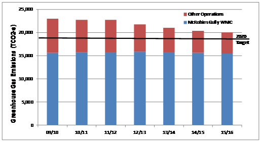
2.3. In 2015-2016, the City’s corporate emissions dropped by 433 tonnes CO2-equivalent (tCO2-e) from the previous year, giving an overall 10.2% reduction since 2009-2010. The emissions were 20,018 tCO2-e and well on the path to achieving the 2020 target of 18,497 tCO2-e.
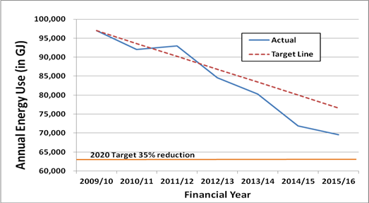
2.4. Energy use was reduced by 3.0% in 2015-2016 compared to the previous year and is 28.7% lower than 2009-2010. This is significantly ahead of progress required to achieve the 35% reduction by 2019-2020.
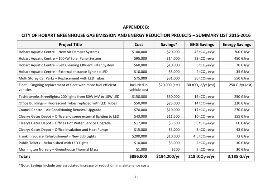
2.5. A number of energy efficiency projects were completed in 2015-2016, with several projects being at the Doone Kennedy Hobart Aquatic Centre, including the installation of 100 kilowatts of solar panels. Other works included more efficient heating, indoor and outdoor LED lighting upgrades, improved hot water services and ongoing improvements to the City’s plant and fleet.
2.6. The City’s Energy Savings Action Plan 2014-2017 will continue to be implemented, along with further projects identified through energy audits and assessment of improving technologies. By the end of the 2016-2017 year, most of the specific actions in the current Plan will have been completed. A new Plan will be prepared in the coming months identifying further opportunities for the 2018 to 2020 period.
|
That: 1. A further report be provided in 12 months on the City’s corporate greenhouse gas emissions and energy use including a new Energy Savings Action Plan for the period 2018 to 2020. 2. Opportunities for positive media about the City’s emissions and energy reductions be sought.
|
4. Background
4.1. This report has been prepared in response to the resolution made at the City Infrastructure Committee meeting of 26 August 2015, being: “A further report be provided in 12 months on the City’s corporate greenhouse gas emissions and energy use”.
4.2. A report on the City’s corporate energy use and greenhouse gas emissions has been provided annually over recent years with information on the City’s progress towards achieving targets of a 17% reduction in greenhouse gas emissions and a 35% drop in energy use from 2010 levels by 2020.
4.3. The City’s Energy Savings Action Plan covers the period 2014 to 2017 and lists actions to be undertaken to reduce energy use.
4.4. A report providing detailed information on energy use and greenhouse gas emissions for 2015-2016 is provided as Attachment A.
Greenhouse Gas Emissions
4.5. In regard to greenhouse gas emissions, revised values of global warming potential factors were included in the National Greenhouse Accounts in August 2015. The major change impacting on the City’s emissions was an increase in the factor for methane from 21 to 25, as a result of improved understanding of how methane affects the climate.
4.6. To enable direct comparison, the emissions calculations from previous years were adjusted to allow for this change. Thus the amounts provided in this report are not directly comparable with those stated in reports from previous years.
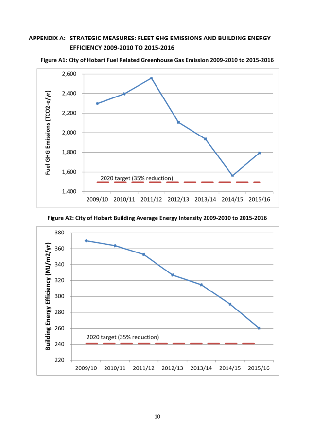
4.7. Based on the revised amount in 2015-2016, the City’s corporate emissions dropped by 433 tonnes CO2-equivalent (tCO2-e) from the previous year, giving an overall 10.2% reduction since 2009-2010. The 2015-2016 emissions were 20,018 tCO2-e and well on the path to achieving the 2020 target of 18,497 tCO2-e.
4.8. The most significant source of the City’s greenhouse gas emissions is the McRobies Gully landfill. Refuse takes more than 30 years to fully decompose once it is buried. A significant reduction in waste quantities being landfilled over the past three years has meant emissions from this source have now peaked and are beginning to slowly decline.
4.9. The new Waste Transfer Station and Resource Recovery Centre have enabled improved diversion of waste. The waste landfilled at McRobies Gully in 2015-2016 was almost 10% lower than the previous year. In addition the green waste collection service is expected to further reduce the amount of waste going to landfill.
4.10. Landfill gas collection has previously been installed to minimise these emissions, but there is a limit to the proportion of gas that can be extracted.
4.11. Given this limitation most of the reduction in greenhouse gas emissions has to be achieved through reduced fuel use and lower electricity consumption, both of which are discussed is more detail below.
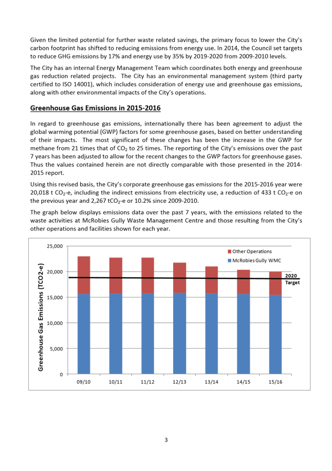
4.12. The graph below displays the trend in greenhouse gas emissions over the past 7 years with the 2020 target shown along with the emissions from McRobies Gully Waste Management Centre and other City operations.
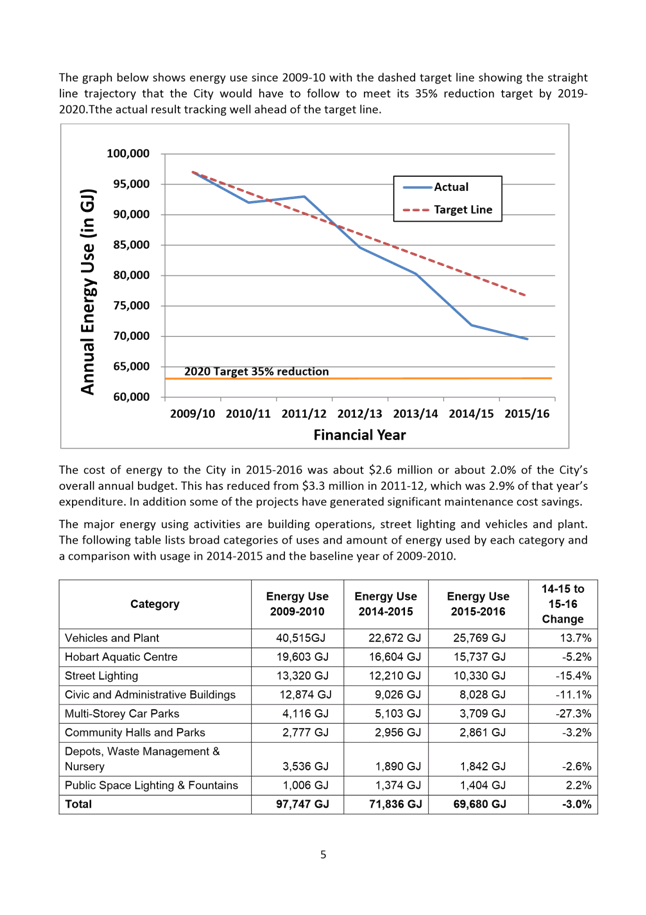
Energy Use
4.13. Energy use across the City’s facilities and operations was reduced by 3.0% in 2015-2016 compared to the previous year and is 28.7% lower than 2009-2010. This is significantly ahead of progress required to achieve the 35% reduction by 2019-2020.
4.14. The information by sector shows an increase in energy use in the vehicles and plant sector. However this is considered to be due to some data being reported in the wrong year previously, with the long term trend being a continuing fall in usage.
4.15. Some sectors such as street lighting, civic and administration buildings and multi-storey car parks had reductions of over 10% in energy use compared to the previous year.
4.16. The graph below shows the decline that has been achieved over the period 2009-2010 to 2015-2016. The dotted line represents the amount needed for the City to achieve target if the reduction was made evenly during the period. The lower line represents the 2020 target of a 35% reduction from 2009-2010 usage.
4.17. A number of energy efficiency projects were completed in 2015-2016, including the following:
4.17.1. The installation of 100 kilowatts of solar panels at the Doone Kennedy Hobart Aquatic Centre (DKHAC).
4.17.2. Completion of the Australian Government grant funded roll out of energy efficient streetlights.
4.17.3. Replacement of lighting with LED technology in parts of several buildings including the Clearys Gates Depot, Argyle Street and Centrepoint multi-storey car parks, Council Centre, DKHAC and several public conveniences.
4.17.4. More efficient heating and hot water systems in several buildings, including at the Clearys Gates Depot, Council Centre and Town Hall.
4.17.5. Improvements to air handling and filtration mechanical plant at DKHAC.
4.17.6. Further improvements to the fuel efficiency of plant and vehicles.
4.18. The following are the previously approved and more significant projects to be undertaken in 2016-2017:
4.18.1. The installation of solar panels at eleven of the City’s sites, including an additional 200kW at DKHAC.
4.18.2. Replacing about 400 lights in the Town Hall annex and Council Centre with LED panel lights.
4.18.3. Replacing direct electric underfloor heating with heat pumps at the Clearys Gates Depot.
4.18.4. Upgrade of the building management control systems at DKHAC and in the Town Hall, to enable improved control and monitoring of mechanical and electrical plant at the facility.
4.18.5. Upgrade of the Mawson Place cardinal lights to colour adjustable LED lights.
5. Proposal and Implementation
5.1. It is proposed that a further report be provided in 12 months time on the City’s corporate greenhouse gas emissions and energy use and that opportunities for positive media attention continue to be sought.
5.2. The information provided in Attachment A will be finalised in line with corporate branding requirements and be published on the City’s website.
5.3. Energy efficiency and greenhouse gas reduction projects for the 2016-2017 year are being progressed largely as previously identified in the Energy Savings Action Plan, along with newly identified projects.
5.4. Work will be undertaken in 2016-2017 to develop a new Energy Savings Action Plan for the 2018 to 2020 period.
6. Strategic Planning and Policy Considerations
6.1. The projects undertaken to reduce energy use and greenhouse gas emissions support Priority Area of Activity THREE – Environment and Natural Resources in the Capital City Strategic Plan 2015 - 2025, specifically Strategic Objective 3.4 - Leadership in environmental performance with the efficient use of natural resources, including the following:
6.1.1. Action 3.4.2 Improve corporate environmental sustainability.
6.1.2. Action 3.4.3 Implement corporate greenhouse emission reduction activities identified in the Council’s Climate Change Strategy.
6.1.3. Action 3.4.4 Implement the Energy Savings Action Plan.
7. Financial Implications
7.1. Funding Source and Impact on Current Year Operating Result
7.1.1. The funding of greenhouse gas emission and energy use reduction projects was provided from several sources in 2015-2016 including the Greenhouse Gas Reserve Fund, which is set at $100,000 per annum, and the balance of an Australian Government grant to complete the energy efficient street lighting project, along with capital and maintenance funds.
7.1.2. Projects are assessed through business case proposals and normally only undertaken where the payback period is 7 years or less, with the average payback for completed projects having been a little under 5 years.
7.1.3. The total project expenditure in 2015-2016 on projects involving energy efficiency works was about $900,000.
7.2. Impact on Future Years’ Financial Result
7.2.1. It is estimated that the projects completed in 2015-2016 are saving about $190,000 per annum from reduced energy and maintenance costs.
7.2.2. As projects are implemented savings in energy and maintenance costs are identified and incorporated into forward budgets.
7.3. Asset Related Implications
7.3.1. Asset related considerations and life cycle costs are taken into account in the assessment of each project.
8. Legal, Risk and Legislative Considerations
8.1. There are no legislative requirements in regard to energy use or greenhouse gas emissions, with the City’s facilities being below greenhouse gas reporting threshold requirements.
8.2. Reduction in energy use lowers the financial risk to the City in regard to any future increases in energy charges.
9. Environmental Considerations
9.1. Greenhouse gas emissions are continuing to be lowered as the result of projects and operational improvements and thus reducing the City’s environmental footprint.
10. Marketing and Media
10.1. There is potential for positive media for specific actions that the City is taking to reduce energy use and greenhouse gas emissions and also in regard to the overall savings being achieved.
10.2. During and following specific greenhouse gas reduction or energy efficiency improvement actions, opportunities to gain positive media exposure would be sought, as appropriate to the action.
10.3. The report provided as Attachment A will be finalised in line with corporate branding requirements and published on the City’s website, as was undertaken last year.
11. Community and Stakeholder Engagement
11.1. In March 2016 a half day tour of the City’s facilities was held for officers and elected members of southern councils presenting some of the works undertaken to improve energy efficiency and to explain the City’s approach and achievements.
11.2. Some very positive feedback about the tour was received from a number of participants.
12. Delegation
12.1. This is a matter for the City Infrastructure Committee to consider.
As signatory to this report, I certify that, pursuant to Section 55(1) of the Local Government Act 1993, I hold no interest, as referred to in Section 49 of the Local Government Act 1993, in matters contained in this report.
|
Scott Morgan Group Manager Infrastructure Planning |
|
Date: 18 October 2016
File Reference: F16/94332; 17-50-11
Attachment a: Greenhouse
Gas Emissions Report 2015-2016 - Draft Text ⇩ ![]()
|
Item No. 6.5 |
Agenda (Open Portion) City Infrastructure Committee Meeting - 26/10/2016 |
Page 76 ATTACHMENT a |
|
Item No. 6.5 |
Agenda (Open Portion) City Infrastructure Committee Meeting - 26/10/2016 |
Page 87 ATTACHMENT a |
|
Agenda (Open Portion) City Infrastructure Committee Meeting |
Page 88 |
|
|
|
26/10/2016 |
|
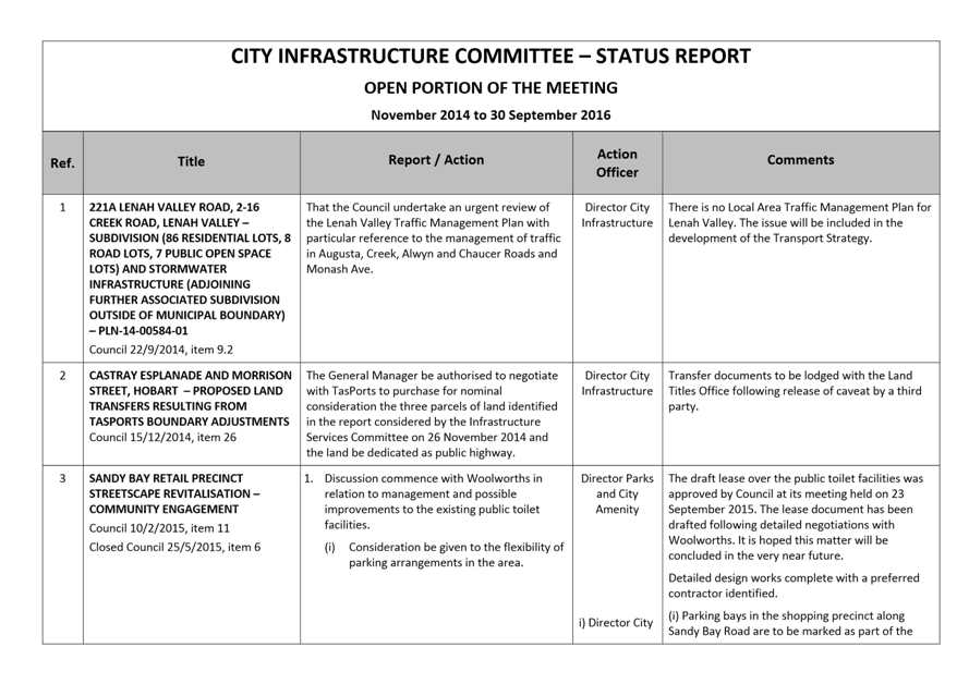
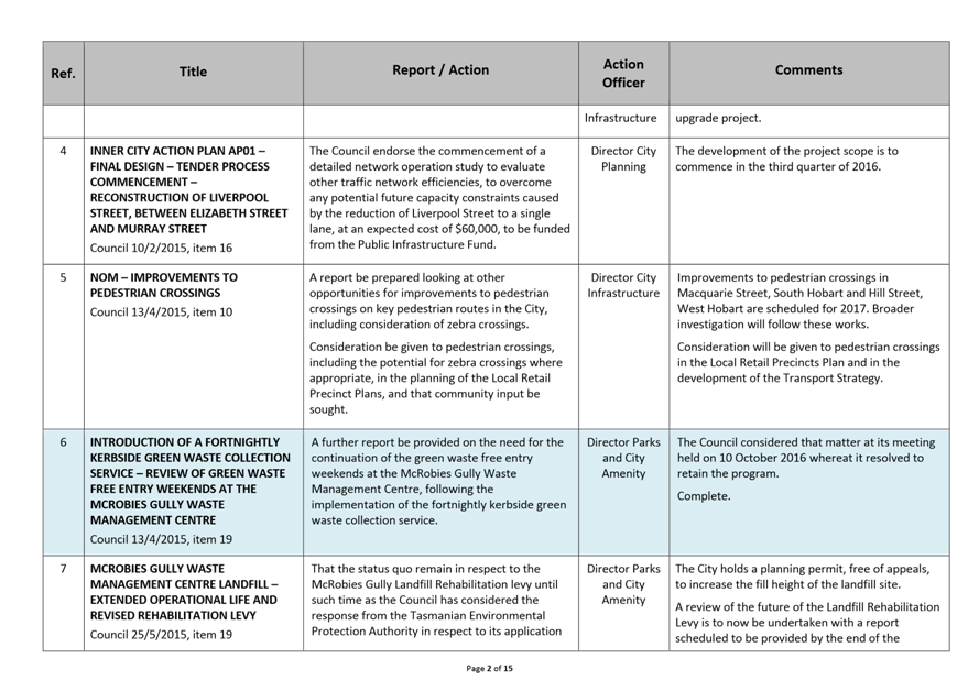
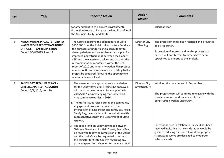
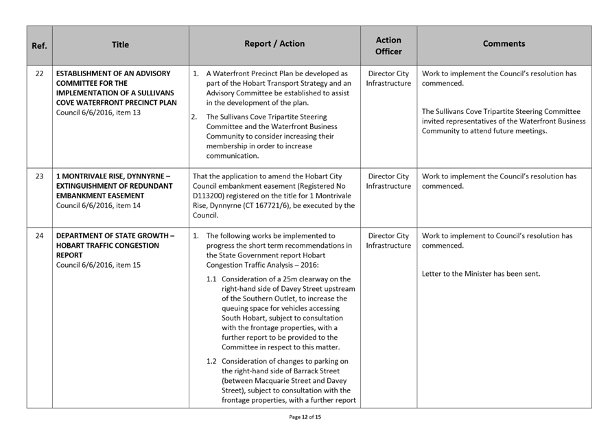
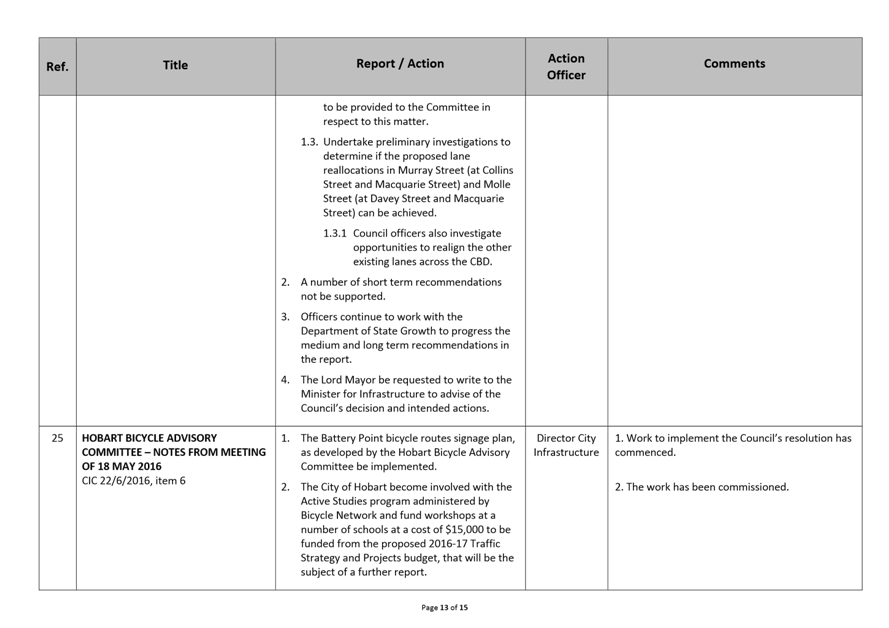
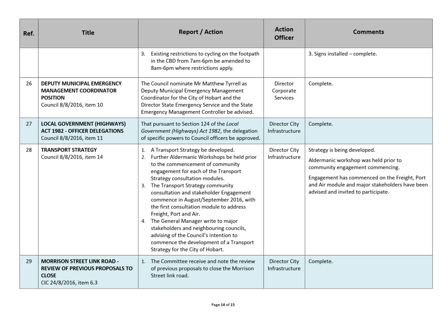
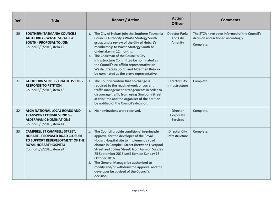
A report indicating the status of current decisions is attached for the information of Aldermen.
REcommendation
That the information be received and noted.
Delegation: Committee
|
Item No. 7.1 |
Agenda (Open Portion) City Infrastructure Committee Meeting - 26/10/2016 |
Page 89 ATTACHMENT a |
|
Agenda (Open Portion) City Infrastructure Committee Meeting |
Page 105 |
|
|
|
26/10/2016 |
|
Regulation 29(3) Local Government
(Meeting Procedures) Regulations 2015.
File Ref: 13-1-10
The General Manager reports:-
“In accordance with the procedures approved in respect to Questions Without Notice, the following responses to questions taken on notice are provided to the Committee for information.
The Committee is reminded that in accordance with Regulation 29(3) of the Local Government (Meeting Procedures) Regulations 2015, the Chairman is not to allow discussion or debate on either the question or the response.”
8.1 Utilisation of Bus Shelter in Macquarie Street
File Ref: F16/113226; 13-1-10
Memorandum of the Director City Infrastructure of 13 October 2016.
8.2 On-street Parking
File Ref: F16/113350; 13-1-10
Memorandum of the Director City Infrastructure of 18 October 2016.
Delegation: Committee
|
That the information be received and noted.
|
|
Item No. 8.1 |
Agenda (Open Portion) City Infrastructure Committee Meeting |
Page 106 |
|
|
26/10/2016 |
|
Memorandum: Lord Mayor
Deputy Lord Mayor
Aldermen
Response to Question Without Notice
Utilisation of Bus Shelter in Macquarie Street
|
Meeting: City Infrastructure Committee
|
Meeting date: 21 September 2016
|
|
Raised by: Alderman Reynolds |
|
Question:
What would be the possibility of bus stop ‘N’ located in Macquarie Street being relocated nearer to Elizabeth Street, enabling commuters to utilise the shelters?
Response:
Officers have been working with Metro Tasmania to investigate the relocation of Bus Stop N on Macquarie Street (adjacent to Franklin Square). Metro Tasmania is working on finalising the bus stop arrangements for the area and will investigate the reorganisation of their bus departure points from the new bus shelters on Macquarie Street (adjacent to Franklin Square).
Whilst Metro Tasmania has advised that they are giving consideration to this matter they have not as yet advised when the investigation will be complete.
As signatory to this report, I certify that, pursuant to Section 55(1) of the Local Government Act 1993, I hold no interest, as referred to in Section 49 of the Local Government Act 1993, in matters contained in this report.
|
Mark Painter Director City Infrastructure |
|
Date: 13 October 2016
File Reference: F16/113226; 13-1-10
|
Item No. 8.2 |
Agenda (Open Portion) City Infrastructure Committee Meeting |
Page 107 |
|
|
26/10/2016 |
|
Memorandum: Lord Mayor
Deputy Lord Mayor
Aldermen
Response to Question Without Notice
On-street Parking
|
Meeting: City Infrastructure Committee
|
Meeting date: 21 September 2016
|
|
Raised by: Alderman Burnet |
|
Question:
What is the Council’s overall plan to retire the on-street parking throughout the City and is this being considered as part of the Transport Strategy Review?
Response:
The City of Hobart has a current strategy in relation to the management of parking, entitled Parking – A Plan for the Future, 2013. The parking strategy acknowledges the Sustainable Transport Strategy and includes a number of actions in response to the goals of the Sustainable Transport Strategy. However, there is currently no specific action around the removal or reuse of on-street car parking spaces across the City – these requests are generally dealt with on a case-by-case basis.
The current development of a transport strategy for the City of Hobart will include the consideration of parking – for cars, bicycles, motorcycles, buses and loading. It is anticipated that the consultation modules related to private transport and local area traffic management will particularly generate issues around the use and management of on-street parking.
As signatory to this report, I certify that, pursuant to Section 55(1) of the Local Government Act 1993, I hold no interest, as referred to in Section 49 of the Local Government Act 1993, in matters contained in this report.
|
Mark Painter Director City Infrastructure |
|
Date: 18 October 2016
|
|
Agenda (Open Portion) City Infrastructure Committee Meeting |
Page 108 |
|
|
26/10/2016 |
|
Section 29 of the Local Government (Meeting Procedures) Regulations 2015.
File Ref: 13-1-10
An Alderman may ask a question without notice of the Chairman, another Alderman, the General Manager or the General Manager’s representative, in line with the following procedures:
1. The Chairman will refuse to accept a question without notice if it does not relate to the Terms of Reference of the Council committee at which it is asked.
2. In putting a question without notice, an Alderman must not:
(i) offer an argument or opinion; or
(ii) draw any inferences or make any imputations – except so far as may be necessary to explain the question.
3. The Chairman must not permit any debate of a question without notice or its answer.
4. The Chairman, Aldermen, General Manager or General Manager’s representative who is asked a question may decline to answer the question, if in the opinion of the respondent it is considered inappropriate due to its being unclear, insulting or improper.
5. The Chairman may require a question to be put in writing.
6. Where a question without notice is asked and answered at a meeting, both the question and the response will be recorded in the minutes of that meeting.
7. Where a response is not able to be provided at the meeting, the question will be taken on notice and
(i) the minutes of the meeting at which the question is asked will record the question and the fact that it has been taken on notice.
(ii) a written response will be provided to all Aldermen, at the appropriate time.
(iii) upon the answer to the question being circulated to Aldermen, both the question and the answer will be listed on the agenda for the next available ordinary meeting of the committee at which it was asked, where it will be listed for noting purposes only.
|
|
Agenda (Open Portion) City Infrastructure Committee Meeting |
Page 109 |
|
|
26/10/2016 |
|