
City
of hobart
AGENDA
Council Meeting
Open Portion
Monday, 20 February 2023
at 5.00 pm
Council Chamber, Town Hall
SUPPLEMENTARY ITEM
ORDER OF BUSINESS
City
of hobart
AGENDA
Council Meeting
Open Portion
Monday, 20 February 2023
at 5.00 pm
Council Chamber, Town Hall
SUPPLEMENTARY ITEM
ORDER OF BUSINESS
|
|
Supplementary Agenda (Open Portion) Council Meeting |
Page 2 |
|
|
20/2/2023 |
|
The Chief Executive Officer reports:
“That in accordance with the provisions of Part 2 Regulation 8(6) of the Local Government (Meeting Procedures) Regulations 2015, these supplementary matters are submitted for the consideration of the Committee.
Pursuant to Regulation 8(6), I report that:
(a) information in relation to the matter was provided subsequent to the distribution of the agenda;
(b) the matter is regarded as urgent; and
(c) advice is provided pursuant to Section 65 of the Act.”
|
Item No. 27 |
Supplementary Agenda (Open Portion) Council Meeting |
Page 3 |
|
|
20/2/2023 |
|
27. Sandy Bay Neighbourhood Plan
File Ref: F23/9176; 23/5
Report of the Chief Executive Officer of 17 February 2023.
Delegation: Council
|
Item No. 27 |
Supplementary Agenda (Open Portion) Council Meeting |
Page 11 |
|
|
20/2/2023 |
|
Sandy Bay Neighbourhood Plan
Purpose
The purpose of this report is to provide Council with an update on the preparation of the Structure Plan for Sandy Bay; as per Council’s resolution on 12 December 2022, where Council resolved as follows:
1. The preparation of a Structure Plan be expedited as part of the Future Hobart program of work and prioritised by the Chief Executive Officer accordingly for commencement in early 2023.
2. The Chief Executive Officer prepare a further report that details the scope of the Structure Plan; geographical areas to be included (ie Mt. Nelson) and a proposed community engagement program and anticipated timeframes for consideration at the Council meeting in February 2023.
Background
The practice of planning for communities is maturing in Tasmania. It’s incumbent on the City of Hobart to plan our suburbs, activity centres and neighbourhoods in such a way to enable our communities to respond to current and emerging global and urban challenges while also delivering liveable neighbourhoods.
Through the development of the Future Hobart Plan; a number of structure plans are being developed for each suburb (with an activity centre) to ensure that the City of Hobart is at the forefront of urban planning policy, process and outcomes.
Planning is a collective endeavor, requiring the input, investment and commitment of government, agencies, industry and most importantly community. Preparing a structure plan requires a collaborative effort to generate ideas and shape a collective vision unique to each place. The Structure Plans prepared will be flexible and outcomes-focused, providing opportunities for strong community and stakeholder leadership to overcome challenges, or to deliver innovations in planning and development.
Planning for communities is a long-term proposition. It is an opportunity to think creatively and collectively about each place and the unique attributes and contribution it makes to our broader city. A whole-of-council culture to embed collaboration, engagement, strategic thinking and support to establish the vision for each Structure Plan will help individual projects contribute to the long-term plans of each suburb and activity centre within the City of Hobart.
Hobart is made up of diverse and successful neighbourhoods that are experienced differently across the city by locals, visitors, business and industry. Planning communities that feature and protect their natural and cultural heritage, while accommodating desired land use and development activities consistent with contemporary standards, will enable the best outcomes to be achieved in each place.
Having regard to feedback received from community members; it is important to note that the language ‘Structure Plan’ has been replaced with ‘Neighborhood Plan’; to ensure the intent is more clearly understood; albeit acknowledging that it will still from a strategic planning ‘technical’ perspective deliver on the requirements of a ‘Structure Plan’ as described in the previous report to Council on 12 December 2022. ‘Neighborhood Plan’ will also be used to describe other structure planning work currently programmed or underway including North Hobart.
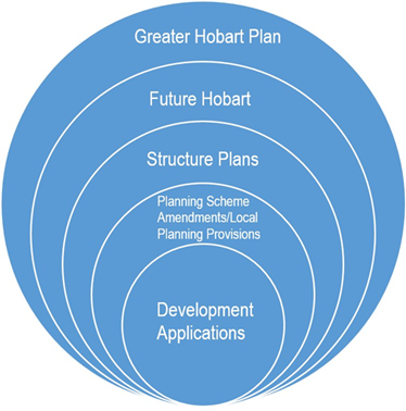
This hierarchy provides a framework for decision making regarding the use and development of land in Hobart. Structure plans define a council’s preferred direction of the future of a suburb and articulate how it will be managed. While the Greater Hobart Plan sets out the basic principles for suburbs across Greater Hobart, there is no 'one size fits all' solution. Each area within the City of Hobart is unique and as such we need to work closely with our communities to determine exactly how their suburb and neighbourhoods should provide for changing community needs.
The Future Hobart Plan and associated Neighborhood Plans (Structure Plans) will be informed by extensive community engagement and in this case will be underpinned by the International Association for Public Participation (IAP2). It is intended that the Neighborhood Plans (Structure Plans) guide any changes to land use, built form and public spaces that together can achieve economic, social, cultural and environmental objectives for the suburb.
Neighborhood Planning (structure planning) enables Council to:
· Provide greater certainty to the local community and investors about its expectations for the future form of development in its suburbs and centres.
· Manage change to ensure suburbs and activity centres are attractive, vibrant areas to live, work and shop.
· Provide and advocate from other levels of government for the provision of appropriate levels of infrastructure and services to meet future needs of community.
· Ensure economic, cultural and social vitality of the area.
· Make best use of council resources and focus council investment to best serve the community.
Sandy Bay Neighbourhood Plan
Sandy Bay presents a unique city-shaping opportunity to create a well-connected, diverse and vibrant, mixed-use suburb on the fringe of Hobart’s Central Business District (CBD).
Guided by the United Nations Sustainable Development Goals (UN SDGs), the Neighborhood Plan will support the sustainable growth of Sandy Bay, advancing Hobart’s reputation as a sustainable, liveable and thriving city. The plan will provide a mechanism to help tackle urban challenges now and into the future. Delivering more diverse housing typologies, forward planning for infrastructure and prioritizing active transport will help alleviate housing stress and reduce reliance on private vehicles. The plan will further support Hobart’s aspirations of being powered by 100% renewable energy by 2040.
The Neighborhood Plan will facilitate the provision of land uses that complement those in the CBD and the surrounding landscape and natural environment. This will advance Hobart’s aspirations of becoming Australia’s most economical, environmental and connected community by 2030.
The Sandy Bay Neighborhood Plan will provide a pathway forward for the area to grow sustainably, delivering liveable neighbourhoods and supporting the City’s vision for Hobart to be one of the world’s greatest small cities.
The Neighbourhood Plan will include recommendations for policies, development controls and projects to guide planning and sustainable growth. This project also provides the opportunity to collaborate with the community and key stakeholders to deliver a revitalised and activated precinct.
The Plan will guide:
· Land use
· Built form
· Sporting and entertainment infrastructure
· public realm, activation and wayfinding
· open space provision
· transport integration
· sustainability
· integration with the broader Hobart CBD
Neighbourhood Plan Boundaries
Located directly south of the Hobart CBD and adjoining Battery Point, Sandy Bay sits on the western shore of the River Derwent. Figure 1 identifies the approximate boundaries of the study area subject to the Sandy Bay Neighborhood Plan.
The study area extends from Byron Street to the north, to Mount Nelson and Cartwright Creek to the south. The study area extends east towards the waterfront of the River Derwent and as far west as Proctors Road, inclusive of the University Soccer Club.
The Neighbourhood Plan study area captures sites of significance such as:
· Sandy Bay
· Alexandra Battery Park
· Wrest Point Casino
· Sandy Bay Rivulet
· Dr Syntax Hotel
· Mount Nelson
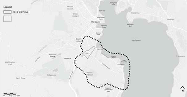
Figure 1: Approximate Study Boundary Area
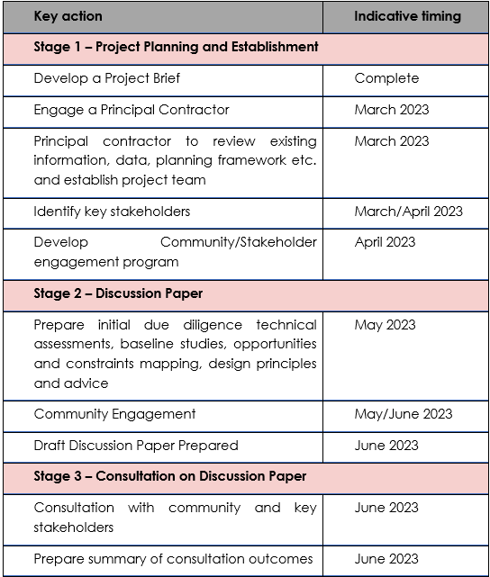
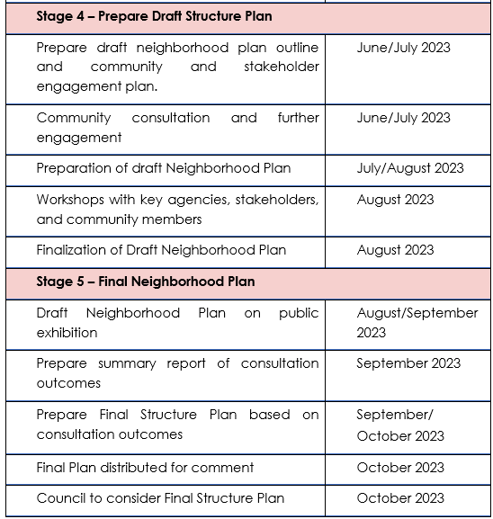
The key objective of this project will be to work with the community and key stakeholders to prepare a Discussion Paper, the Sandy Bay Neighborhood Plan and an Implementation Program.
The key objectives driving the scope of the Plan include:
· Establish a shared vision and framework for the future growth and development of the Sandy Bay study area.
· Deliver the vision of Sandy Bay as a well-connected, diverse and vibrant, mixed-use precinct on the fringe of Hobart’s CBD, and advance Hobart’s reputation as a sustainable, livable and successful city.
· Optimise the economic role of Sandy Bay and ensure the benefits are far-reaching across Hobart and Tasmania.
· Undertake extensive engagement with the community, landowners within the study area, and key stakeholders throughout the planning process.
· Identify the key characteristics of the locality that is to be preserved and celebrated as positive representations of Sandy Bay’s identity.
· Identify and account for the existing land use pattern and constraints of the area and the influence this has on future development.
· Identify the ideal land use pattern, optimal built form and scale of development for the subject site which is based on a range of inputs including design, planning, economic, social and heritage.
· Identify key opportunity sites that can be transformed to enhance the development of the study area, including complementary land uses and opportunity for increase and diverse housing typologies.
· Identify and enhance active mobility, accessibility and permeability through prioritisation of active transport modes and private vehicular movements.
· Understand the open space, community, transport and infrastructure provision requirements to meet the needs of the precinct as it evolves across the planning horizon.
· Outline a broader development vision for the study area and prepare visual mapping that guides this vision in future development.
· Identify opportunities to develop tourism and visitor economy as well as night-time economy.
· Develop a placemaking implementation strategy.
· Identify opportunities to enhance the environment and landscape values.
|
That the Council endorse the Sandy Bay Neighbourhood Plan Boundaries and indicative timing of the key planning milestones of the project.
|
As signatory to this report, I certify that, pursuant to Section 55(1) of the Local Government Act 1993, I hold no interest, as referred to in Section 49 of the Local Government Act 1993, in matters contained in this report.
|
Kelly Grigsby Chief Executive Officer |
|
Date: 17 February 2023