City
of hobart
AGENDA
City Infrastructure Committee Meeting
Open Portion
Wednesday, 2 March 2022
at 5.15 pm
via Zoom
City
of hobart
AGENDA
City Infrastructure Committee Meeting
Open Portion
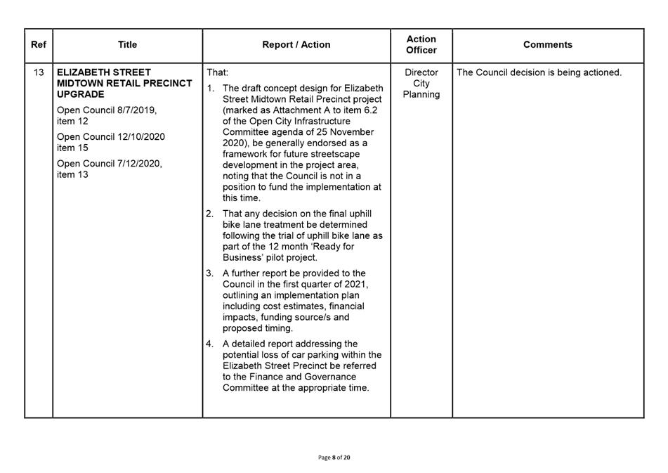
Wednesday, 2 March 2022
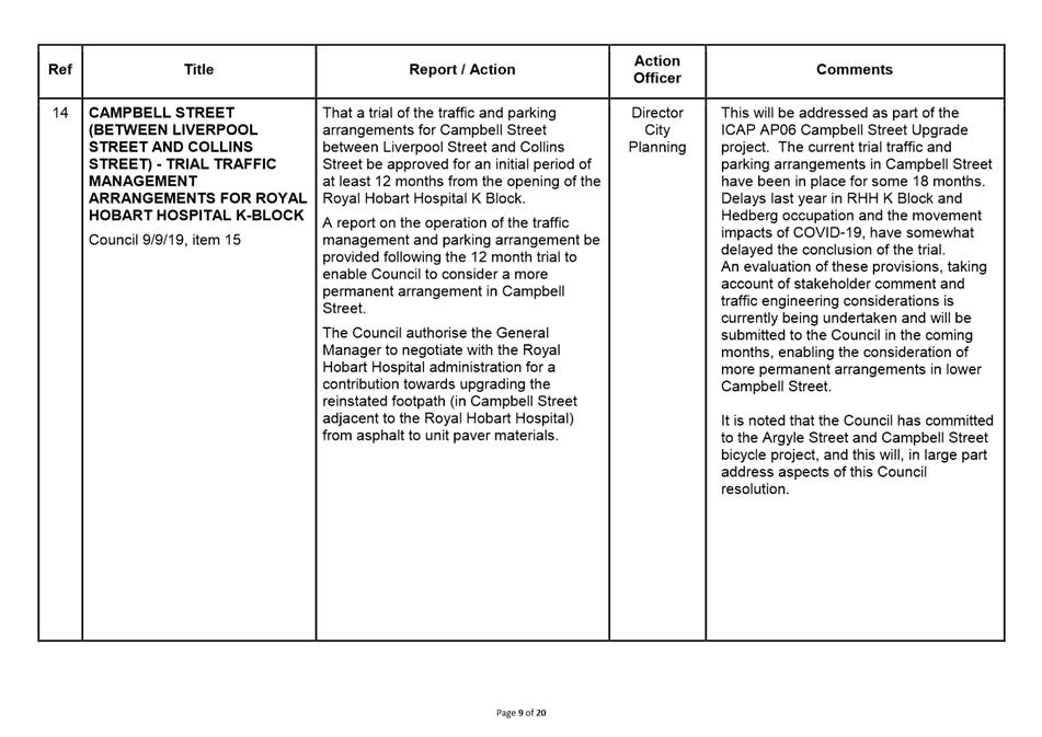
at 5.15 pm
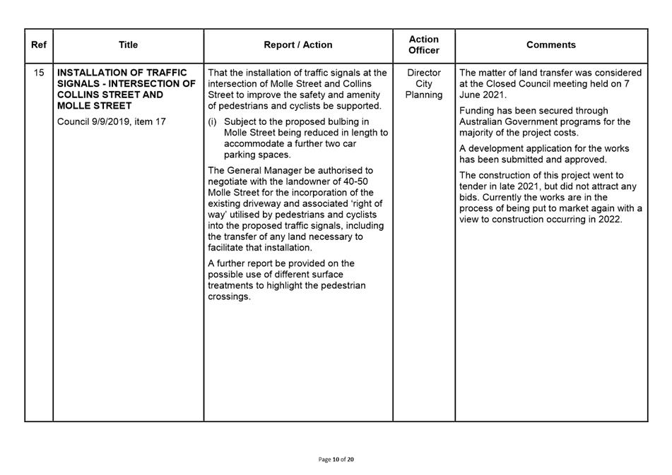
via Zoom
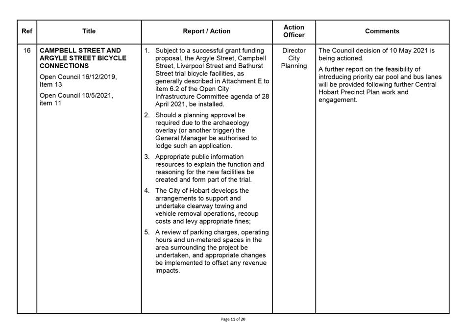
Working together to make Hobart a better place for the community.
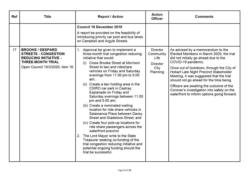
THE VALUES
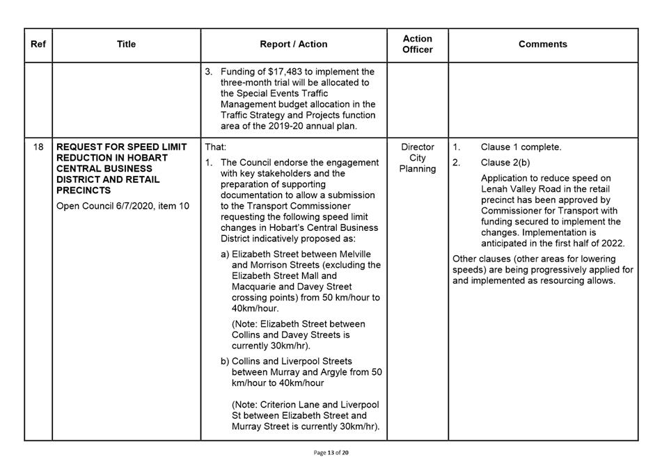
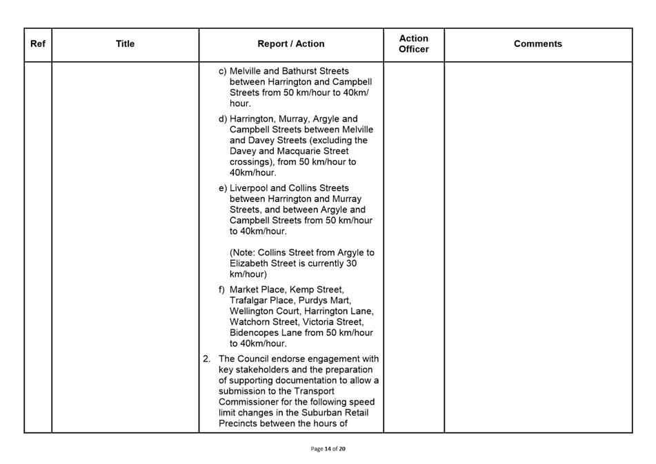
The Council is:
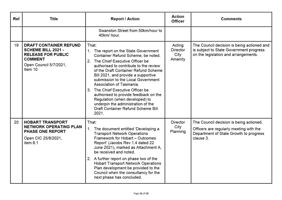
|
People |
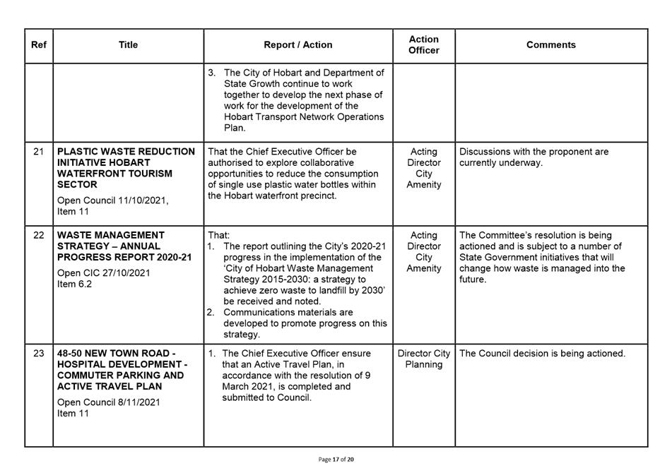
We care about people – our community, our customers and colleagues. |
|
Teamwork |
We collaborate both within the organisation and with external stakeholders drawing on skills and expertise for the benefit of our community. |
|
Focus and Direction |
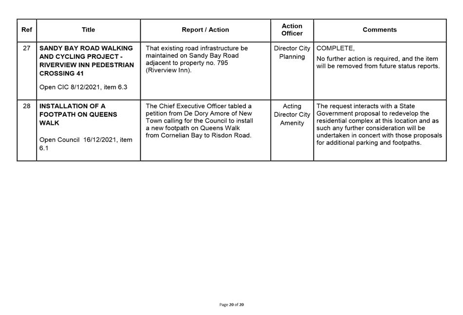
We have clear goals and plans to achieve sustainable social, environmental and economic outcomes for the Hobart community. |
|
Creativity and Innovation |
We embrace new approaches and continuously improve to achieve better outcomes for our community. |
|
Accountability |
We are transparent, work to high ethical and professional standards and are accountable for delivering outcomes for our community. |
|
|
Agenda (Open Portion) City Infrastructure Committee Meeting |
Page 3 |
|
|
2/3/2022 |
|
Business listed on the agenda is to be conducted in the order in which it is set out, unless the committee by simple majority determines otherwise.
APOLOGIES AND LEAVE OF ABSENCE
1. Co-Option of a Committee Member in the event of a vacancy
3. Consideration of Supplementary Items
4. Indications of Pecuniary and Conflicts of Interest
6.1 Petitions - Haig Street and Augusta Road, Lenah Valley - Road Safety Concerns
6.2 Federal Street, North Hobart Footpath Trees
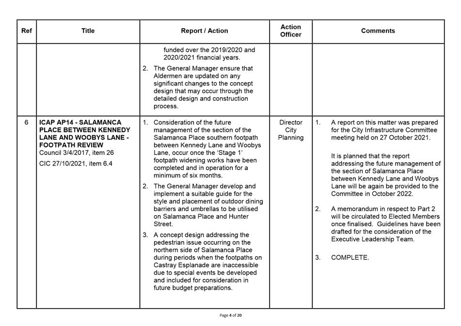
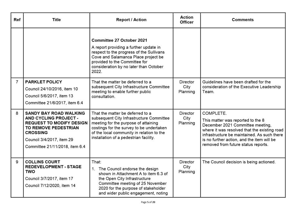
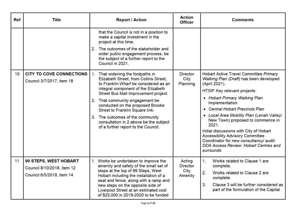
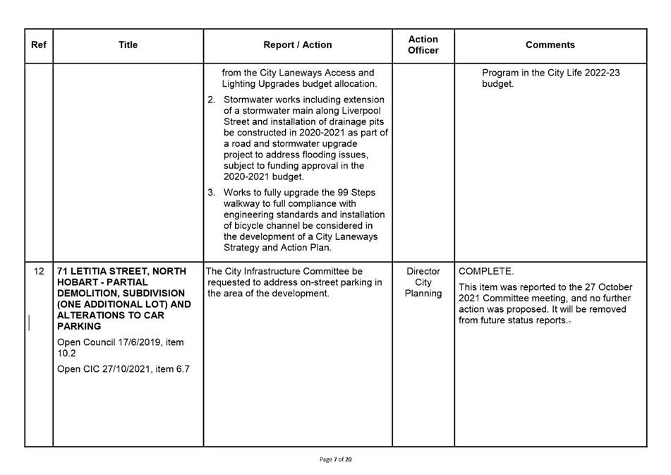
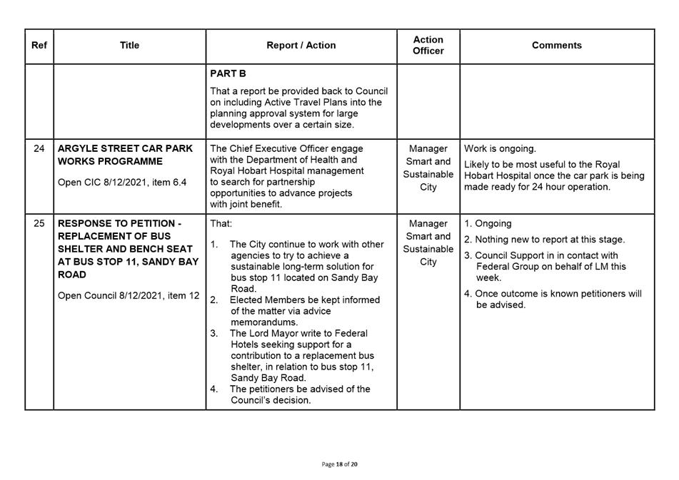
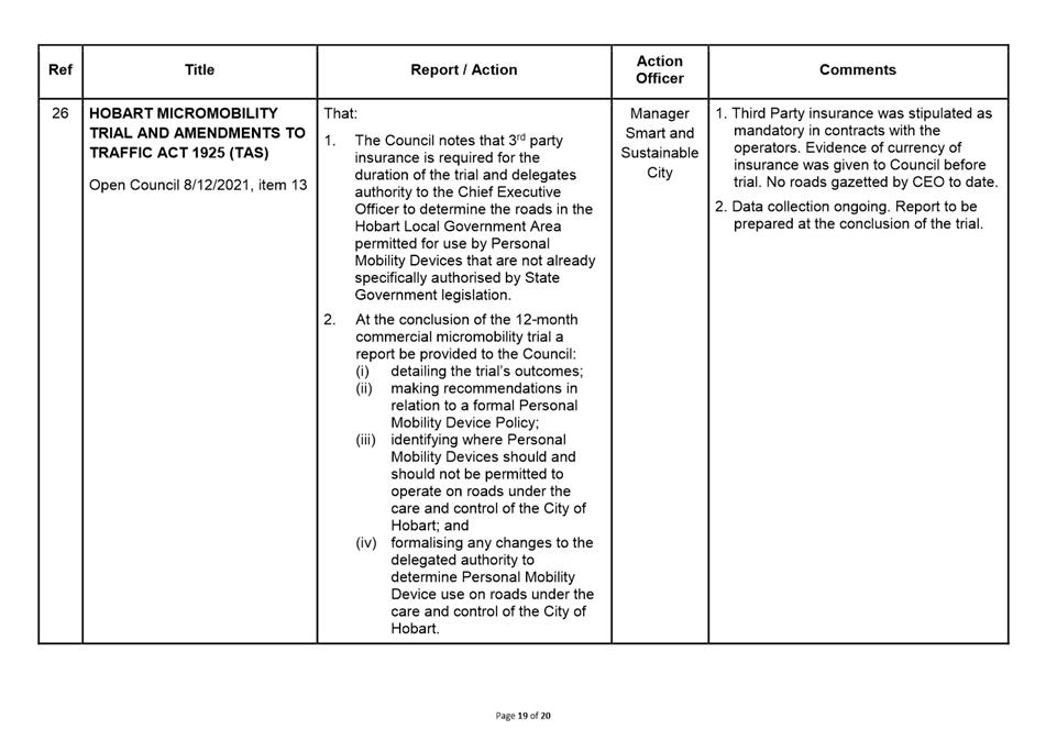
7. Committee Action Status Report
7.1 Committee Actions - Status Report
9. Closed Portion Of The Meeting
|
|
Agenda (Open Portion) City Infrastructure Committee Meeting |
Page 4 |
|
|
2/3/2022 |
|
City Infrastructure Committee Meeting (Open Portion) held Wednesday, 2 March 2022 at 5.15 pm via Zoom.
This meeting of the City Infrastructure Committee is held in accordance with a Notice issued by the Premier on 3 April 2020 under section 18 of the COVID-19 Disease Emergency (Miscellaneous Provisions) Act 2020.
The title Chief Executive Officer is a term of reference for the General Manager as appointed by Council pursuant s.61 of the Local Government Act 1993 (Tas).
|
COMMITTEE MEMBERS Councillor W F Harvey (Chairman) Lord Mayor A M Reynolds Deputy Lord Mayor H Burnet Alderman S Behrakis Councillor J Fox
NON-MEMBERS Alderman M Zucco Alderman J R Briscoe Alderman Dr P T Sexton Alderman D T Thomas Councillor M S C Dutta Councillor Dr Z E Sherlock Councillor W N S Coats |
Apologies:
Leave of Absence: Nil.
|
|
The minutes of the Open Portion of the City Infrastructure Committee meeting held on Wednesday, 2 February 2022, are submitted for confirming as an accurate record.
|
Ref: Part 2, Regulation 8(6) of the Local Government (Meeting Procedures) Regulations 2015.
|
That the Committee resolve to deal with any supplementary items not appearing on the agenda, as reported by the Chief Executive Officer.
|
Ref: Part 2, Regulation 8(7) of the Local Government (Meeting Procedures) Regulations 2015.
Members of the Committee are requested to indicate where they may have any pecuniary or conflict of interest in respect to any matter appearing on the agenda, or any supplementary item to the agenda, which the Committee has resolved to deal with.
Regulation 15 of the Local Government (Meeting Procedures) Regulations 2015.
A Committee may close a part of a meeting to the public where a matter to be discussed falls within 15(2) of the above regulations.
In the event that the Committee transfer an item to the closed portion, the reasons for doing so should be stated.
Are there any items which should be transferred from this agenda to the closed portion of the agenda, or from the closed to the open portion of the agenda?
|
Agenda (Open Portion) City Infrastructure Committee Meeting |
Page 6 |
|
|
|
2/3/2022 |
|
6.1 Petitions - Haig Street and Augusta Road, Lenah Valley - Road Safety Concerns
Report of the Acting Manager City Mobility and the Director City Futures of 24 February 2022.
Delegation: Council
|
Item No. 6.1 |
Agenda (Open Portion) City Infrastructure Committee Meeting |
Page 22 |
|
|
2/3/2022 |
|
REPORT TITLE: Petitions - Haig Street and Augusta Road, Lenah Valley - Road Safety Concerns
REPORT PROVIDED BY: Acting Manager City Mobility
Director City Futures
1. Report Purpose and Community Benefit
1.1. This report has been written to assist the Committee in considering two petitions that were received at meetings of the Hobart City Council and referred to the City Infrastructure Committee.
1.2. There is no specific community benefit aim to this report. At this stage the report is an administrative response to provide information to Committee.
2. Report Summary
2.1. In 2021, two petitions relating to community road safety concerns in Lenah Valley were presented to meetings of the Hobart City Council.
2.2. At the 5 July 2021 meeting of the Hobart City Council, a petition signed by 28 signatories was tabled. The petition called for the Council to.
2.2.1. Implement traffic calming measures on Haig Street, Lenah Valley to restrict traffic volumes and speed e.g. traffic islands, speed humps, mid-block chicanes, local traffic only signage.
2.3. At the 25 October 2021 meeting of the Hobart City Council, a petition signed by 73 signatories was tabled. The petition called for the Council to:
2.3.1. Monitor and gather vehicle travel speeds on the section of Augusta Road between Giblin Street and Athleen Avenue
2.3.2. Investigate and report on crash data on the section of Augusta Road between Giblin Street and Athleen Avenue since the installation of the pedestrian refuge in June 2015
2.3.3. Investigate and implement within a reasonable timeframe, in consultation with the local community, a multi-modal solution for the section of Augusta Road between Giblin Street and Athleen Avenue that is nationally consistent with safe system infrastructure and knowledge, which may involve, but is not limited to, reducing opportunities for vehicles speeding, providing separated and protected cycleways and planting street trees.
2.4. Concerns have been raised for many years by various residents of Haig Street about the use of Haig Street by ‘through’ traffic, and the safety and amenity concerns that residents have about this use.
2.5. Haig Street carries in the order of 1,000 vehicle movements per weekday, with in the order of two thirds of these vehicle movements being people who do not reside in the street utilising it as a through road. The recorded 85th percentile vehicle speed (the speed that 85 out of every 100 drivers using the street are travelling slower than) is 54 km/h.
2.6. In the past the street has been considered too steep to be suitable for the installation of road humps (which if installed would result is slight reductions in vehicle speed and volume, but which would also cause noise and amenity loss to residents close to each road hump), and treatments that would reduce vehicle speeds and volumes effectively (the closure of access to and from Haig Street via Augusta Road) would be likely to be contentious with residents in the street.
2.7. Overall, it is the opinion of officers that on Haig Street there is unlikely to be a treatment that delivers sufficient benefit to justify its cost that would be supported by enough residents in the street to make it practical.
2.8. The recommended proposal is that any treatments for Haig Street be considered as part of the overall Local Area Mobility Plan (LAMP) process planned to be undertaken for the various Hobart suburbs in the coming years. This process is intended to be one where priorities for mobility infrastructure upgrades are determined for each suburb in a consultative process with stakeholders.
2.9. In 2015, a road safety treatment was installed on Augusta Road between Haig Street and Creek Road aimed at:
2.9.1. Improving safety and accessibility for pedestrians crossing Augusta Road.
2.9.2. Improving safety for right turning vehicles entering side roads and driveways.
2.9.3. Lowering vehicle speeds, reducing the risk and severity of crashes.
2.9.4. The facilitation of a future stage involving the installation of bicycle lanes.
2.10. The treatment installed was a median treatment, including a series of pedestrian islands with associated kerb ramps, and bicycle lanes for cyclists traveling in an uphill direction.
2.11. During consultation with stakeholders, it became apparent that the installation of a pedestrian island and median treatment on a curve in Augusta Road was a matter of concern, due to advice from a stakeholder that in the past there had been a number of crashes involving vehicles running off the road at the curve, and a crash involving a driver running into a residents vehicle as the resident was accessing their driveway.
2.12. A number of changes were made to the design, including widening the residents driveway, and reducing the amount of on-street parking to be removed to facilitate the pedestrian crossing (to allow the resident to park on street in front of their property should they wish to continue to use the on-street parking rather than the driveway).
2.13. The view of officers at the time was that given the demonstrated history of these median treatments offering positive road safety benefits, and given the pedestrian crossing location was the only feasible location to provide a crossing point that met the Australian Standards for installation, the basic treatment was appropriate and would be installed.
2.14. In the 6.4 years since the installation, the pedestrian median island has been struck / mounted by a vehicle on several occasions. While it is common for these type of islands to be struck, requiring the signage on the island to be repaired, because of the history of concerns at this location this tends to raise the concerns of the community each time it occurs.
2.15. A survey of vehicle speeds was undertaken on Augusta Road between Suncrest Avenue and Shawfield Street in December 2021. In 2007, a survey at the same location had shown that the 85th percentile vehicle speed was 60.5 km/h. The December 2021 survey showed that vehicle speeds had dropped significantly, with the 85th percentile vehicle speed reducing by 11.4% to 53.6 km/h.
2.16. A review of the crash data collected by Tasmania Police shows that when comparing the rate of crashes for the 6.4 years since the installation of the treatment with the 6.4 years prior to the installation of the treatment:
2.16.1. At the curve at #149-#153 Augusta Road, where the pedestrian island was installed, the crash rate has reduced by 50% after treatment, compared to the equivalent period pre-treatment.
2.16.2. For the overall treatment on Augusta Road of which that island formed part, the crash rate has reduced by 33% after treatment, compared to the equivalent period pre-treatment.
2.16.3. The crash reductions recorded as a result of the treatment are significantly higher than those that would be expected if no treatment had been implemented.
2.16.4. On Augusta Road – Lenah Valley Road from the western end of the treatment to the Athleen Avenue intersection, the crash rate in the equivalent period reduced by 29%. This is a marginally better improvement than the 20% improvement recorded at a ‘control’ site on Augusta Road to the east where no treatments have been installed.
2.17. Overall the speed reductions achieved, and the significant reductions in the rate of crashes recorded would indicate that the treatment has been successful.
2.18. While there may be an appetite in the community for the infrastructure in Augusta Road to be reviewed and reconsidered again following the 2015 works, there are many streets in the City of Hobart that have never had a review or upgrade, that would also benefit from such a review.
2.19. In recent years, the City of Hobart has focused on working closely with the community to plan and implement complex and at times contentious changes to streets in local retail precincts (Sandy Bay, Lenah Valley, the Salamanca Precinct, New Town, Mid Town, South Hobart). These are complex and resource intensive processes, requiring significant staffing resources and if successful in arriving at a suitable design, significant new asset funding to deliver.
2.20. Given the large amount of work that has been put into the management of Augusta Road and Lenah Valley Road between Giblin Street and Athleen Avenue in recent years, and given the good results that this work has achieved, it is proposed that no further work be undertaken until such time as planning for the implementation of an on-road cycling route along this corridor commences, or projects are identified through the Local Area Mobility Plan (LAMP) process.
|
That: 1. Mobility improvements be investigated for Augusta Road and Haig Street as part of the overall Local Area Mobility Plan (LAMP) process. 2. The petitioners be advised of the outcomes of officer findings as outlined within this report. |
4. Background
4.1. In 2021, two petitions relating to community road safety concerns in Lenah Valley were presented to meetings of the Hobart City Council.
4.2. At the 5 July 2021 meeting of the Hobart City Council, a petition signed by 28 signatories was tabled. The petition called for the Council to:
4.2.1. Implement traffic calming measures on Haig Street, Lenah Valley to restrict traffic volumes and speed e.g. traffic islands, speed humps, mid-block chicanes, local traffic only signage.
4.3. At the 25 October 2021 meeting of the Hobart City Council, a petition signed by 73 signatories was tabled. The petition called for the Council to:
4.3.1. Monitor and gather vehicle travel speeds on the section of Augusta Road between Giblin Street and Athleen Avenue.
4.3.2. Investigate and report on crash data on the section of Augusta Road between Giblin Street and Athleen Avenue since the installation of the pedestrian refuge in June 2015.
4.3.3. Investigate and implement within a reasonable timeframe, in consultation with the local community, a multi-modal solution for the section of Augusta Road between Giblin Street and Athleen Avenue that is nationally consistent with safe system infrastructure and knowledge, which may involve, but is not limited to, reducing opportunities for vehicles speeding, providing separated and protected cycleways and planting street trees.
4.4. This report has been prepared to assist the City Infrastructure Committee in considering what action it wishes to take in response to the petition.
4.5. The two petitions have been combined as they essentially cover very similar topics, and the geographic areas of the two petitions adjoin.
4.6. Figure 1, below, shows the general locality with the roads covered by the two petitions highlighted.
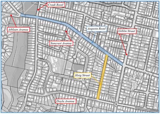
Figure 1 – Locality Plan of ‘Augusta Road’ and ‘Haig
Street’ Petitions
5. Matters Raised in the Subject Petitions – Haig Street - Discussion
5.1. The ‘Haig Street’ petition called for the Council to:
5.1.1. Implement traffic calming measures on Haig Street, Lenah Valley to restrict traffic volumes and speed e.g. traffic islands, speed humps, mid-block chicanes, local traffic only signage.
5.2. Concerns have been raised for many years by various residents of Haig Street about the use of Haig Street by ‘through’ traffic, and the safety and amenity concerns that residents have about this use.
5.3. The most recent vehicle speed and volume survey undertaken in Haig Street (in May 2017), Haig Street carried an average of 1057 vehicle movements per weekday, with an 85th percentile vehicle speed of 54 km/h.
5.4. With about 40 households on Haig Street, and with a typical household generating about 8 vehicle movements per day, in the order of two thirds of the vehicle movements on Haig Street would be expected to be road users using the street as a through route.
5.5. These road users are typically using the route over Mount Stuart, and are using Haig Street as the connection between Lenah Valley Road – Augusta Road and Doyle Avenue. The most appropriate road for road users to utilise as an alternative would be Giblin Street, as it is a road that serves an arterial function in the network, and the intersection of Giblin Street and Augusta Road, and the intersection of Giblin Street and Doyle Avenue are treated with traffic signals and a roundabout respectively.
5.6. The main concerns that have been raised in the past by residents of Haig Street have been:
5.6.1 The safety of the Augusta Road / Haig Street intersection, with ‘through’ traffic performing the right turn into Haig Street at speeds seen by some residents as too high;
5.6.2 The safety of Haig Street itself, with concerns that drivers are travelling too fast;
5.6.3 The safety of the Haig Street / Doyle Avenue intersection, with ‘through’ traffic performing the right turn into Haig Street at speeds seen by some residents as too high, resulting in these drivers ‘cutting the corner’;
5.6.4 The reduction in the amenity of residents from the additional ‘through’ traffic on the street.
5.7. Overall, in the 22 years (January 2000 to present) to which access is available to crash data recorded by Tasmania Police, there have been:
5.7.1 One recorded crashes at the Haig Street / Augusta Road intersection. The crash, which occurred in 2001 involved a driver on Augusta Road losing control after trying to avoid an animal at night. The crash resulted in property damage only.
5.7.2 Six recorded crashes on Haig Street itself. Of these, all six resulted in property damage only. Two of these crashes occurred in the last 5 years.
5.7.3 One recorded crash at the Haig Street / Doyle Avenue intersection. The crash, which occurred in 2006 involved a driver under the influence of alcohol on Doyle Avenue striking a parked car near the intersection. The crash resulted in property damage only.
5.8. In summary, in the 22 years to which we have access to data, there have been no crashes at the Augusta Road / Haig Street, or Haig Street / Doyle Avenue intersections involving vehicles entering or exiting Haig Street. There have been six reported crashes in Haig Street itself, all resulting in property damage only, and only two of these crashes have occurred in the last 5 years.
5.9. In the past, it has been the opinion of officers that Haig Street in its current form is capable of reasonably carrying the approximately 1000 vehicle movements a day that it carries, and the cost of any treatment likely to be acceptable to residents would not be justifiable given the low benefits it would be likely to generate.
5.10. The treatment that would resolve the concerns of residents would be to close access to and from Haig Street from Augusta Road. This would remove all through traffic from the street, and therefore resolve any safety and amenity concerns associated with this through traffic. It would also inconvenience those residents in the street that currently come and go via Augusta Road, a portion of those residents would strongly oppose this treatment.
5.11. Another practical treatment is to install a scheme of road humps on Haig Street. Installing a typical scheme of a series of four road humps would be expected to cost in the order of $60,000, and would be expected to reduce the volume and speed of through traffic slightly (a 10% reduction in both operating speed and vehicle volume would be a reasonable expectation). This treatment could be expected to reduce traffic volumes from about 1057 vehicles per weekday to about 950 vehicles per weekday, and the 85th percentile vehicle speed from about 54 km/h to about 49 km/h. This may have some marginal benefits to safety and amenity, but those residents whose houses are in close proximity to the four road hump installations will experience additional noise from the deceleration and acceleration of vehicles as they approach, strike, and depart from the humps. There is a likelihood that some residents will strongly oppose such a treatment on this basis. In the past it has also been the view of officers that Haig Street is too steep to be appropriate for a road hump scheme.
5.12. At the intersection of Haig Street and Doyle Avenue, it would be feasible to install a small median island on Haig Street to prevent drivers cutting the corner when turning right from Doyle Avenue into Haig Street.
5.13. Overall, it is the opinion of officers that on Haig Street there is unlikely to be a treatment that delivers sufficient benefit to justify its cost that would be supported by enough residents in the street to make it practical.
5.14. The recommended proposal is that any treatments for Haig Street be considered as a part of the overall Local Area Mobility Plan (LAMP) process planned to be undertaken for the various Hobart suburbs in the coming years. This process is intended to be one where priorities for mobility infrastructure upgrades are determined for each suburb in a consultative process with stakeholders.
6. Matters Raised in the Subject Petitions – Augusta Road - Discussion
6.1. The ‘Augusta Road’ petition called for the Council to:
6.1.1. Monitor and gather vehicle travel speeds on the section of Augusta Road between Giblin Street and Athleen Avenue.
6.1.2. Investigate and report on crash data on the section of Augusta Road between Giblin Street and Athleen Avenue since the installation of the pedestrian refuge in June 2015.
6.1.3. Investigate and implement within a reasonable timeframe, in consultation with the local community, a multi-modal solution for the section of Augusta Road between Giblin Street and Athleen Avenue that is nationally consistent with safe system infrastructure and knowledge, which may involve, but is not limited to, reducing opportunities for vehicles speeding, providing separated and protected cycleways and planting street trees.
6.2. By way of background, the petition appears to have been precipitated by a vehicle striking a pedestrian refuge island on Augusta Road at 153 / 160 Augusta Road. That pedestrian refuge island was installed by the City of Hobart as a part of a larger scheme aimed at improving road safety, pedestrians and cyclists amenity on Augusta Road between Creek Road and Giblin Street, which was installed in 2015.
6.3. In 2014, the City of Hobart identified that this section of Augusta Road would benefit from an intervention to improve its safety and amenity. Initially the identified issue was that a resident at 160 Augusta Road, who relied on a wheelchair and the Metro Tasmania bus service, had no appropriate means of crossing Augusta Road to access that Bus Service.
6.4. A successful funding bid was made under the State Government ‘Vulnerable Road User’ Program to develop and implement a project who’s outcomes would be:
6.4.1. Improved safety and accessibility for pedestrians crossing Augusta Road.
6.4.2. Improved safety for right turning vehicles entering side roads and driveways.
6.4.3. Lower vehicle speeds, reducing the risk and severity of crashes.
6.4.4. The facilitation of a future stage involving the installation of bicycle lanes.
6.5. A report was provided to the 8 September 2014 meeting of Council, where it was resolved in part:
“That Pedestrian islands and a median lane be installed on Augusta Road, Lenah Valley between Giblin Street and Creek Road with funding allocated from the Safer Roads: Vulnerable Road User Program ($38,400) and the City of Hobart’s 2014/2015 New Asset Black Spot Allocation ($9,500)”
6.6. Consultation was undertaken with stakeholders. The main issues raised during the consultation were:
6.6.1. Concern about the loss of on-street car parking;
6.6.2. Concern about access to and from driveways;
6.6.3. Concern about the appropriateness and safety of the pedestrian island planned for installation at 153-160 Augusta Road given its proximity to the curve on Augusta Road to the west of the Augusta Road / Suncrest Avenue intersection.
6.7. A number of changes were made to the concept design to resolve these issues. The matter of the treatment at the curve west of the Augusta Road / Suncrest Avenue intersection remained, and remains contentious.
6.8. In particular, a resident in the vicinity of the curve was concerned that there had been a number of crashes at this location in the past, and that the treatment would not be beneficial or would make the situation worse. The resident was also concerned that the installation would make it more difficult (and less safe) for the resident to enter and exit the driveway to their property.
6.9. Changes were made to the design (widening of the residents driveway crossover, and retaining on-street parking so the resident could continue to park on-street if they did not wish to use the driveway, but after careful consideration, it was the view of officers that the overall treatment would improve road safety, and would benefit pedestrians by providing a number of safer crossing points.
6.10. This view, is based on the long and demonstrated history of the basic treatment (a median treatment formed of parallel dashed lines that narrows the width of the road, and which provides a sheltered separated space for right turning drivers and pedestrians seeking to cross an arterial road) delivering reductions in the rate and severity of crashes.
6.11. The pedestrian crossing point at 153-160 Augusta Road was seen as a priority part of the project at the time, as a resident in a wheelchair was unable to cross Augusta Road to access a bus service in an appropriate and safe manner, and this location was the only space that would both serve the needs of this resident and comply with the Australian Standards for the locations of treatments of this type.
6.12. Since the installation of the treatment in 2015, the pedestrian island has been struck by a through vehicle on a number of occasions, and repairs have been required to the signage on the island. This is not unusual. Median islands are mounted by vehicles across the city on a weekly basis. Given the concerns of some local residents about the safety of the treatment, when this occurs it does reignite the issue.
6.13. In terms of the matters raised in the petition:
Monitor and gather vehicle travel speeds on the section of Augusta Road between Giblin Street and Athleen Avenue;
6.14. A survey of vehicle travel speeds was conducted on Augusta Road, midway between Augusta Road / Suncrest Avenue, and the Augusta Road / Shawfield Avenue intersections over 7 days from the 8th to the 20th December 2021. This survey location, is the same location as where an earlier survey was undertaken in 2007.
6.15. In December 2021, the 85th percentile vehicle speed was recorded as 53.6 km/h.
6.16. In the same location, in August 2007, the 85th percentile vehicle speed was recorded as 60.5 km/h.
Investigate and report on crash data on the section of Augusta Road between Giblin Street and Athleen Avenue since the installation of the pedestrian refuge in June 2015
6.17. The pedestrian refuge was installed as part of the overall treatment, constructed in various stages from January to July 2015.
6.18. For the overall treatment, which runs from #127 to #157 Augusta Road:
6.18.1. In the 6.4 years from 1 August 2015 to 31 December 2021, a total of six crashes were reported to Tasmania Police. This included 3 crashes resulting in injury, and three resulting in property damage.
6.18.2. When compared to the 6.4 year period prior to construction (1 August 2008 to 31 December 2014), this represents a 33% reduction in the rate of crashes.
6.19. For the curve where the pedestrian crossing point is located (the frontage of #149 to #153 Augusta Road inclusive):
6.19.1. In the 6.4 years from 1 August 2015 to 31 December 2021, a total of one crash was reported to Tasmania Police. This crash resulted in property damage only.
6.19.2. When compared to the 6.4 year period prior to construction (1 August 2008 to 31 December 2014), this represents a 50% reduction in the rate of crashes.
6.19.3. Looking at the full crash history (from 1 January 2000 to present), there were 7 crashes recorded in the 15 years prior to implementation of the treatment (including three injury crashes and four property damage crashes). This represents a 67% reduction in the rate of crashes per year at the location since the treatment was installed.
6.20. In terms of the crash data for Augusta Road – Lenah Valley Road from the frontage of #159 Augusta Road to the Lenah Valley Road / Athleen Avenue Intersection:
6.20.1. In the 6.4 years from 1 August 2015 to 31 December 2021, a total of 15 crashes were reported to Tasmania Police. This included 5 crashes resulting in injuries (3 first aid at the scene, and two minor injury), and 10 crashes resulting in property damage only.
6.20.2. When compared to the 6.4 year period prior to the completion of the median island near Suncrest Avenue on 1 August 2015, when 5 injury and 16 property damage crashes were reported this represents a 28% reduction in the rate of crashes.
6.20.3. Looking at the full crash history (from 1 January 2000 to present), there were 65 crashes recorded in the 15.5 years prior to implementation of the treatment (including 18 injury crashes and 47 property damage crashes). This represents a 44% reduction in the rate of crashes per year on this section of Augusta Road.
6.20.4. In this section, the City of Hobart in recent years has undertaken several road safety interventions, including:
6.20.4.1. The installation of a pedestrian island on Lenah Valley Road in front of the RSL building (about 70 metres west of the Creek Road / Lenah Valley Road intersection) where road safety audits had identified that large numbers of pedestrians were crossing without protection.
6.20.4.2. The upgrade of the Athleen Avenue / Lenah Valley Road intersection to allow an accessible pedestrian path of travel, and to reduce the speed of drivers turning left from Lenah Valley Road into Athleen Avenue.
6.20.4.3. Changes were also made at the Creek Road / Lenah Valley Road intersection under the State Government Blackspot Program to address a developing crash problem at the intersection.
6.21. The crash data, summarised in Figure 2, shows good reductions in the rate of crashes occurring on Lenah Valley Road – Augusta Road where these treatments have been implemented.
6.21.1. Overall, crash rates have reduced across the arterial road network following the reduction in speed limit from 60km/h to 50 km/h implemented by the City of Hobart and department of State Growth. As a ‘control’, crash data for Augusta Road between Murchison Street and Raluana Lane (an equivalent length of Augusta Road, located on the city side of the Lenah Valley Retail Precinct, where no infrastructure changes have been made for many years) were checked. In that section, the crash rate in the 6.4 years since the subject Augusta Road treatment was installed was 20% reduced on the 6.4 year period prior.
6.21.2. At the curve at #149-#153 Augusta Road, where the pedestrian island was installed, the crash rate has reduced by 50% after treatment, compared to the equivalent period pre-treatment.
6.21.3. For the overall treatment on Augusta Road of which that island formed part, the crash rate has reduced by 33% after treatment, compared to the equivalent period pre-treatment.
6.21.4. The crash reductions recorded as a result of the treatment are significantly higher than those that would be expected if no treatment had been implemented.
6.21.5. On Augusta Road – Lenah Valley Road from the western end of the treatment to the Athleen Avenue intersection, the crash rate in the equivalent period reduced by 29%. This is a marginally better improvement than that recorded at the ‘control’ site where no treatments have been installed.
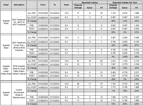 Figure 2 –
Augusta Road – Lenah Valley Road Crash Data Summary
Figure 2 –
Augusta Road – Lenah Valley Road Crash Data Summary
Investigate and implement within a reasonable timeframe, in consultation with the local community, a multi-modal solution for the section of Augusta Road between Giblin Street and Athleen Avenue that is nationally consistent with safe system infrastructure and knowledge, which may involve, but is not limited to, reducing opportunities for vehicles speeding, providing separated and protected cycleways and planting street trees.
6.22. At the time of the development of the scheme implemented in 2015 the feedback from stakeholders identified strong opposition to the removal of the small amount of on-street parking that a basic road / pedestrian safety scheme required.
6.23. Options for more significant cycling infrastructure (separated bicycle lanes, or cycling lanes in both directions rather than the current uphill cycling lanes) were not pursued, as it was felt that there was little potential for success at that time. The installation of the ‘uphill’ cycling lanes was seen as an important initial step to provide some improvement for cyclists, and more importantly to indicate to the public that Augusta Road was seen as an important cycling route, such that future changes that provided better cycling facilities would be more acceptable.
6.24. In recent years, the City of Hobart has focused on working closely with the community to plan and implement complex and at times contentious changes to streets in local retail precincts (Sandy Bay, Lenah Valley, the Salamanca Precinct, New Town, Mid Town, South Hobart). These are complex and resource intensive processes, requiring significant staffing resources and if successful in arriving at a suitable design, significant new asset funding to deliver.
6.25. Given the large amount of work that has been put into the management of Augusta Road and Lenah Valley Road between Giblin Street and Athleen Avenue in recent years, and given the good results that this work has achieved, it is proposed that no further work be undertaken until such time as planning for the implementation of an on-road cycling route along this corridor commences, or projects are identified through the Local Area Mobility Plan (LAMP) process.
7. Proposal and Implementation
7.1. It is proposed to advise petitioners of the outcomes of officer findings as outlined within this report and advise that mobility improvements will be investigated for Augusta Road and Haig Street as part of the overall Local Area Mobility Plan (LAMP) process planned to be undertaken for the various Hobart suburbs in the coming years. This process is intended to be one where priorities for mobility infrastructure upgrades are determined for each suburb in a consultative process with stakeholders.
8. Strategic Planning and Policy Considerations
8.1. Pillar five of the ‘Capital City Strategic Plan 2019-29’ focuses on Movement and connectivity. The following strategies, contained in Outcome 5.1 “An accessible and connected city environment helps maintain Hobart’s pace of life”, and Outcome 5.2 “Hobart has effective and environmentally sustainable transport systems” are considered relevant to this matter:
5.1.1 Improve connectivity throughout Hobart’s inner city and suburbs.
5.1.2 Consider social, environmental and economic elements in transport and technology decision-making.
5.1.3 Investigate transport and technology possibilities that reinforce values of efficiency, sustainability, connection and helping people to meet the needs of daily life.
5.1.4 Ensure equal access is factored into transport and technology decision-making.
5.1.5 Increase the climate resilience of transport and connectivity networks.
5.1.6 Work with stakeholders to prioritise low emission, energy efficient, renewable transport and technology initiatives, including trialling emerging solutions.
5.1.7 Collaborate with stakeholders and business on the efficient, sustainable and innovative movement of people, information and goods.
5.2.3 Develop, upgrade and maintain the City’s network of roads, bridges, cycleways, footpaths and walkways.
5.2.4 Identify and implement infrastructure improvements to enhance access and road safety and reduce air and noise pollution.
5.2.5 Prioritise opportunities for safe and integrated active transport.
5.2.6 Increase the recognition of Hobart as a ‘walking city’, encouraging walking as a fundamental mode of transport.
5.2.7 Support and encourage more people to ride bicycles through the development of safe paths and streets, separated cycleways, end-of-journey facilities and related infrastructure
8.2. Undertaking the works suggested by the petitioners would largely be in keeping with these strategies. The strategic policy issue is that there are likely other streets in the City of Hobart where the significant funding and time resources needed could more effectively deliver these strategies.
8.3. It is recommended that the focus be on working with the community to develop Local Area Mobility Plans (LAMP’s) for each suburb. This is a means to determine each suburbs priority projects, so as to most effectively plan and implement the projects across the City that can best deliver on the strategies identified in the Capital City Strategic Plan.
9. Financial Implications
9.1. Currently there are no financial impacts.
10. Legal, Risk and Legislative Considerations
10.1. None are foreseen.
11. Delegation
11.1. The matter is delegated to Council for determination.
As signatory to this report, I certify that, pursuant to Section 55(1) of the Local Government Act 1993, I hold no interest, as referred to in Section 49 of the Local Government Act 1993, in matters contained in this report.
|
Owen Gervasoni Acting Manager City Mobility |
Katy Cooper Director City Futures |
Date: 24 February 2022
File Reference: F21/118967; R0325
|
Item No. 6.2 |
Agenda (Open Portion) City Infrastructure Committee Meeting |
Page 23 |
|
|
2/3/2022 |
|
6.2 Federal Street, North Hobart Footpath Trees
Report of the Acting Manager Road and Capital Works and the Acting Director City Amenity of 25 February 2022.
Delegation: Council
|
Item No. 6.2 |
Agenda (Open Portion) City Infrastructure Committee Meeting |
Page 24 |
|
|
2/3/2022 |
|
REPORT TITLE: Federal Street, North Hobart Footpath Trees
REPORT PROVIDED BY: Acting Manager Road and Capital Works
Acting Director City Amenity
1. Report Purpose and Community Benefit
1.1. The purpose of this report is to outline action for the treatment of the southern Federal Street footpath, between Elizabeth Street and Argyle Street.
2. Report Summary
2.1. The footpath is in poor condition and requires renewal.
2.1.1. The footpath surrounding the existing trees is in particularly poor condition, with tree roots causing heaving of both the walkway and kerb.
2.2. The report provides information on the various options considered to enable replacement of the trees.
2.2.1. Removal of trees and reinstate with standard footpath.
2.2.2. Removal of trees and reinstatement in the same location.
2.2.3. Retain trees and improve surrounding footpath.
2.2.4. Removal of trees and replacement in the parking lane of the southern side of the road.
2.2.5. Removal of trees and replacement in the median of the road.
2.2.6. Removal of trees and replacement in the median of the road with the removal of one bicycle lane.
2.2.7. Removal of trees and replacement in the parking lane of the Northern side of the road.
2.2.8. Remediation of the footpath as an interim measure and a review of the streetscape be undertaken as part of the North Hobart Precinct Planning project.
|
That: 1. The footpath on Federal Street, between Argyle and Elizabeth Street, be remediated to make it safe for pedestrians. 2. The future management of trees in the streetscape be considered as part of the North Hobart Precinct Plan project planned for this year. |
4. Background
4.1. The footpath located on the southern side of Federal Street has been deteriorating over time and requires renewal. The project is funded as part of the 2021-22 Capital Works program.
4.2. After defining this project, one of the key considerations was the mitigation of the impact of damage from the existing street trees.
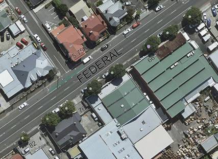
4.3. There are eight semi mature plane trees along the southern side of the road, shown in the figure below:
4.4. Concerns were received by adjacent building owners that the tree roots are affecting their structures. A consultant was engaged to investigate these concerns in 2020. The findings were as follows:
4.4.1. The trees are generally in good condition.
4.4.2. The trees are not currently impacting the structures integrity.
4.5. A thorough assessment has been carried out to consider all available options to remediate the defective footpath.
4.6. The City’s Arborist provided the following comment “The mature trees provide substantial shade, greening and canopy in an area of the city that is very low in canopy and they have a long remaining life expectancy. These trees are in good condition and are all in the lowest possible risk category under Councils internationally recognised tree risk assessment methodology (QTRA)”
4.7. The following options were considered:
4.7.1. Removal of trees and reinstate with standard footpath.
4.7.1.1. Provides the best outcome for the road infrastructure, minimises ongoing maintenance and reduces the risk to pedestrians regarding tree heaving.
4.7.1.2. The removal of the trees does not meet the objectives of the Councils Street Tree Strategy.
4.7.2. Removal of trees and reinstatement in the same location.
4.7.2.1. Replacing with more appropriate tree species was entertained, however replacement was found to be unfeasible due to the extensive underground services in the planting locations. This includes infrastructure already under the existing trees.
4.7.3. Retain trees and improve surrounding footpath.
4.7.3.1. Design options were developed with the idea of retaining the existing trees and reinforcing the surrounding built infrastructure, as well as increasing the tree surround size to reduce risk of tree root heaving.
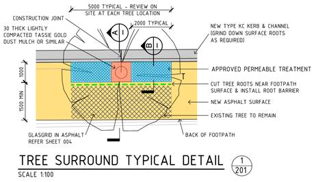
4.7.3.2. This option includes a reinforced asphalt footpath surface, increased reinforcement at the kerb & channel and increasing the size tree surround, which comprises of an approved permeable treatment.
4.7.3.3. A life cycle cost analysis was carried out by an external quantity surveyor, to assess the potential additional cost of the maintenance with this treatment. This was determined to be $90,000, in current day costs over a 75 year period. This excludes any non-tangible cost such as additional administrative cost to manage complaints or public enquiries.
4.7.3.4. The comments from the City Arborist were considered, namely the good health and amenity value of the trees.
4.7.3.5. Alternative planting methods need to be further considered including raised beds, sealed cells and combination of smaller trees and plantings
4.7.4. Removal of trees and replacement in the parking lane of the southern side of the road.
4.7.4.1. Replacing with more appropriate tree species was entertained, but replanting was unfeasible due to a number of underground services existing in the planting locations.
4.7.4.2. Alternative planting methods need to be considered including raised beds, sealed cells and combination of smaller trees and plantings.
4.7.5. Removal of trees and replacement in the median of the road, realignment of the two bicycle lanes.
4.7.5.1. This option allowed the planting of 5 trees, in a 1m wide median, with two 1.5m wide non separated bike lanes.
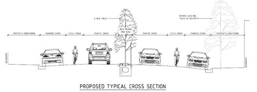
4.7.5.2. Due to only minimum bike lane widths being achieved, an external road safety audit was conducted.
4.7.5.3. The road safety audit raised issues that could not be overcome. This position was confirmed by Councils Traffic Engineers.
4.7.6. Removal of trees and replacement in the median of the road, with the removal of one bicycle lane.
4.7.6.1. To overcome issues highlighted in the Road Safety Audit, the removal of one existing cycle lane was explored.
4.7.6.2. This was deemed not appropriate due to the importance of the cycling link between Elizabeth and Argyle Streets but this needs to be considered in a broader mobility network and observed use of this difficult route.
4.7.7. Removal of trees and replacement in the parking lane of the Northern side of the road.
4.7.7.1. This option allows the potential planting of maximum of 3 trees without the removal of on street parking. This option requires further investigation and input from stakeholders.
4.7.7.2. The presence of overhead power and telecom cables would restrict the height potential of the selected trees, and are not considered a conducive spot for tree planting.
5. Proposal and Implementation
5.1. It is proposed that the footpath repair project be conducted and the existing street trees be retained at this time.
5.2. That the future location and type of trees in Federal Street be considered as part of the North Hobart Precinct Plan project where a broader approach to tree retention, species selection, planting options and canopy extension can be considered for the whole precinct.
6. Strategic Planning and Policy Considerations
6.1. The proposed plan identified in this report is supported by the following elements in the current Strategic Plan.
6.1.1. Pillar 1.2 Hobart’s cityscape reflects the heritage, culture and natural environment that makes it special.
6.1.2. Strategy 1.2.6 Develop and implement public realm design guidelines for streetscapes and public spaces that are high-quality, comfortable, vibrant, walkable and safe.
6.1.3. Pillar 1.3 In City decision making, we consider how different aspects of Hobart life connect and contribute to sense of place.
6.1.4. Strategy 1.3.1 Ensure that social and economic outcomes, climate change, biodiversity and green infrastructure are factored into City design.
6.1.5. Pillar 6.1 – The natural environment is part of the City and biodiversity is preserved, secure and flourishing, specifically Strategy 6.1.5 Enhance urban forests, tree canopy cover and greenery throughout Hobart,
7. Financial Implications
7.1. Funding Source and Impact on Current Year Operating Result
7.1.1. The footpath renewal project is funded in the current financial years capital works program.
7.2. Impact on Future Years’ Financial Result
7.2.1. Ongoing footpath maintenance costs will be undertaken in line with the Councils level of service and further renewal works considered once a precinct plan has been approved.
7.2.2. Quantity surveyor suggests additional cost of $1200 a year in maintenance.
7.3. Asset Related Implications
7.3.1. None identified at this time.
8. Legal, Risk and Legislative Considerations
8.1. The proposed works will ensure that the City meets the objectives of the Local Government (Highways) Act 1982 and ensures public safety while an integrated planning approach is undertaken for the precinct.
9. Environmental Considerations
9.1. The retention of the street trees will maintain the presence of vegetation in the area but needs to be considered in light of future use of adjoining properties and the availability of space alongside required transport corridor elements.
10. Social and Customer Considerations
10.1. It is acknowledged that trees provide significant amenity value to the City but the species and placement is causing ongoing issues with the pavement. This has been considered in the process of writing the report and in recognition of the imminent North Hobart Precinct Plan project.
11. Marketing and Media
11.1. Not applicable.
12. Community and Stakeholder Engagement
12.1. This report has been prepared for the purpose of informing the Council of the proposed pathway to resolution in a broader streetscape approach.
12.2. With a Council approval, the affected landowners, including surrounding businesses and residents, will be advised.
12.3. Internal Council stakeholders have been communicated with regarding this reports recommendation.
13. Delegation
13.1. The matter is delegated to the Council for determination
As signatory to this report, I certify that, pursuant to Section 55(1) of the Local Government Act 1993, I hold no interest, as referred to in Section 49 of the Local Government Act 1993, in matters contained in this report.
|
Tom Stares Acting Manager Road and Capital Works |
John Fisher Acting Director City Amenity |
Date: 25 February 2022
File Reference: F22/5882; 25019-0136-03
|
Agenda (Open Portion) City Infrastructure Committee Meeting |
Page 31 |
|
|
|
2/3/2022 |
|
A report indicating the status of current decisions is attached for the information of Elected Members.
REcommendation
That the information be received and noted.
Delegation: Committee
Attachment a: City Infrastructure Committee Open Status Report
|
Item No. 7.1 |
Agenda (Open Portion) City Infrastructure Committee Meeting - 2/3/2022 |
Page 51 ATTACHMENT a |
|
|
Agenda (Open Portion) City Infrastructure Committee Meeting |
Page 52 |
|
|
2/3/2022 |
|
Section 29 of the Local Government (Meeting Procedures) Regulations 2015.
File Ref: 13-1-10
An Elected Member may ask a question without notice of the Chairman, another Elected Member, the Chief Executive Officer or the Chief Executive Officer’s representative, in line with the following procedures:
1. The Chairman will refuse to accept a question without notice if it does not relate to the Terms of Reference of the Council committee at which it is asked.
2. In putting a question without notice, an Elected Member must not:
(i) offer an argument or opinion; or
(ii) draw any inferences or make any imputations – except so far as may be necessary to explain the question.
3. The Chairman must not permit any debate of a question without notice or its answer.
4. The Chairman, Elected Members, Chief Executive Officer or Chief Executive Officer’s representative who is asked a question may decline to answer the question, if in the opinion of the respondent it is considered inappropriate due to its being unclear, insulting or improper.
5. The Chairman may require a question to be put in writing.
6. Where a question without notice is asked and answered at a meeting, both the question and the response will be recorded in the minutes of that meeting.
7. Where a response is not able to be provided at the meeting, the question will be taken on notice and
(i) the minutes of the meeting at which the question is asked will record the question and the fact that it has been taken on notice.
(ii) a written response will be provided to all Elected Members, at the appropriate time.
(iii) upon the answer to the question being circulated to Elected Members, both the question and the answer will be listed on the agenda for the next available ordinary meeting of the committee at which it was asked, where it will be listed for noting purposes only.
|
|
Agenda (Open Portion) City Infrastructure Committee Meeting |
Page 53 |
|
|
2/3/2022 |
|
|
That the Committee resolve by majority that the meeting be closed to the public pursuant to regulation 15(1) of the Local Government (Meeting Procedures) Regulations 2015 because the items included on the closed agenda contain the following matters:
· Closed portion of the Committee Minutes · Closed Question Without Notice
The following items are listed for discussion:-
Item No. 1 Minutes of the last meeting of the Closed Portion of the Committee Meeting Item No. 2 Consideration of supplementary items to the agenda Item No. 3 Indications of pecuniary and conflicts of interest Item No. 4 Committee Action Status Report Item No. 4.1 Committee Actions - Status Report LG(MP)R 15(2)(c)(iii) Item No. 5 Questions Without Notice
|