City
of hobart
AGENDA
City Planning Committee Meeting
Open Portion
Monday, 25 February 2019
at 5:00 pm
Lady Osborne Room, Town Hall
City
of hobart
AGENDA
City Planning Committee Meeting
Open Portion
Monday, 25 February 2019
at 5:00 pm
Lady Osborne Room, Town Hall
THE MISSION
Our mission is to ensure good governance of our capital City.
THE VALUES
The Council is:
|
about people |
We value people – our community, our customers and colleagues. |
|
professional |
We take pride in our work. |
|
enterprising |
We look for ways to create value. |
|
responsive |
We’re accessible and focused on service. |
|
inclusive |
We respect diversity in people and ideas. |
|
making a difference |
We recognise that everything we do shapes Hobart’s future. |
|
|
Agenda (Open Portion) City Planning Committee Meeting |
Page 3 |
|
|
25/2/2019 |
|
Business listed on the agenda is to be conducted in the order in which it is set out, unless the committee by simple majority determines otherwise.
APOLOGIES AND LEAVE OF ABSENCE
1. Co-Option of a Committee Member in the event of a vacancy
3. Consideration of Supplementary Items
4. Indications of Pecuniary and Conflicts of Interest
6. Planning Authority Items - Consideration of Items With Deputations
7. Committee Acting as Planning Authority
7.1 Applications under the Sullivans Cove Planning Scheme 1997
7.2 Applications under the Hobart Interim Planning Scheme 2015
7.2.2 12 Washington Street, South Hobart - Partial Demolition, Alterations and Extension
7.2.3 58-60 Hall Street, Ridgeway - Dwelling
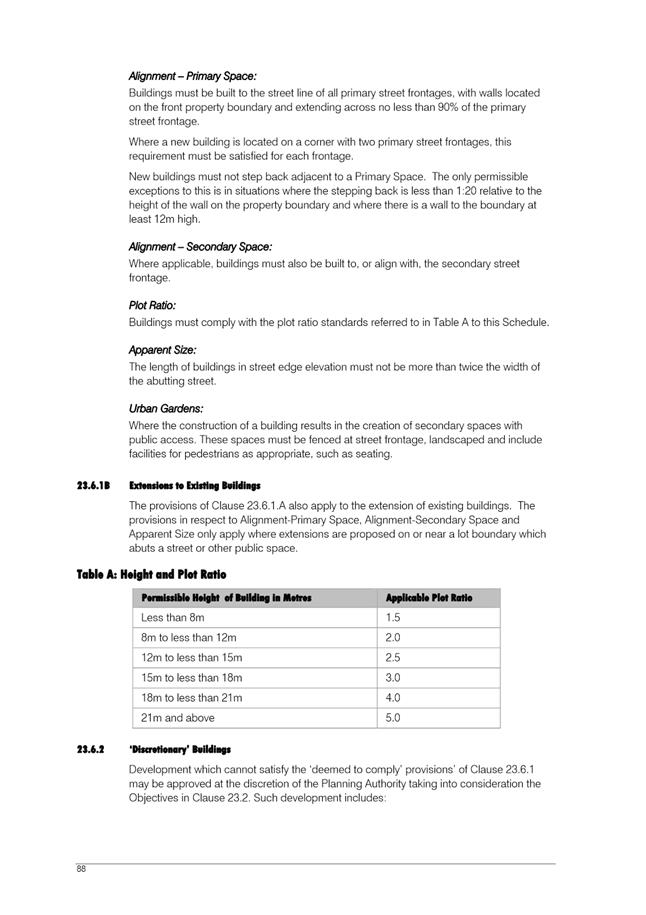
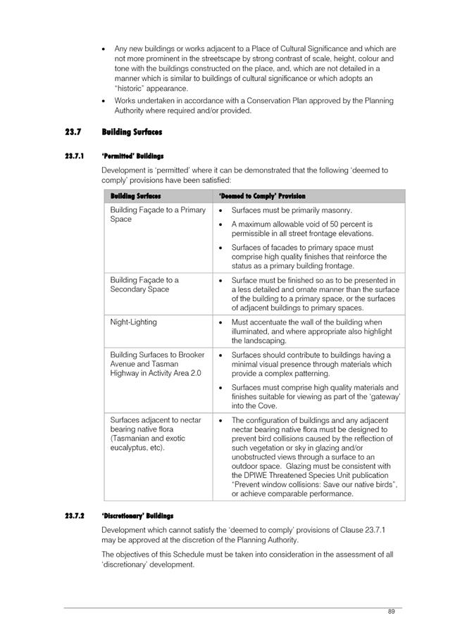
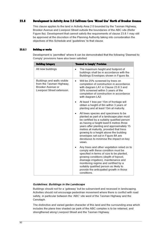
8.3 City Planning - Advertising List
8.4 Delegated Decisions Report (Planning)
9. Responses To Questions Without Notice
9.1 Upgrade to the Molle and Collins Street Intersection
11. Closed Portion Of The Meeting
|
|
Agenda (Open Portion) City Planning Committee Meeting |
Page 5 |
|
|
25/2/2019 |
|
City Planning Committee Meeting (Open Portion) held Monday, 25 February 2019 at 5:00 pm in the Lady Osborne Room, Town Hall.
|
COMMITTEE MEMBERS Deputy Lord Mayor Burnet (Chairman) Briscoe Denison Harvey Behrakis
NON-MEMBERS Lord Mayor Reynolds Zucco Sexton Thomas Dutta Ewin Sherlock |
Apologies:
Leave of Absence: Nil.
|
|
The minutes of the Open Portion of the City Planning Committee meeting held on Tuesday, 12 February 2019, are submitted for confirming as an accurate record.
|
Ref: Part 2, Regulation 8(6) of the Local Government (Meeting Procedures) Regulations 2015.
|
That the Committee resolve to deal with any supplementary items not appearing on the agenda, as reported by the General Manager.
|
Ref: Part 2, Regulation 8(7) of the Local Government (Meeting Procedures) Regulations 2015.
Members of the Committee are requested to indicate where they may have any pecuniary or conflict of interest in respect to any matter appearing on the agenda, or any supplementary item to the agenda, which the Committee has resolved to deal with.
Regulation 15 of the Local Government (Meeting Procedures) Regulations 2015.
A Committee may close a part of a meeting to the public where a matter to be discussed falls within 15(2) of the above regulations.
In the event that the Committee transfer an item to the closed portion, the reasons for doing so should be stated.
Are there any items which should be transferred from this agenda to the closed portion of the agenda, or from the closed to the open portion of the agenda?
In accordance with the requirements of Part 2 Regulation 8(3) of the Local Government (Meeting Procedures) Regulations 2015, the General Manager is to arrange the agenda so that the planning authority items are sequential.
In accordance with Part 2 Regulation 8(4) of the Local Government (Meeting Procedures) Regulations 2015, the Committee by simple majority may change the order of any of the items listed on the agenda, but in the case of planning items they must still be considered sequentially – in other words they still have to be dealt with as a single group on the agenda.
Where deputations are to be received in respect to planning items, past practice has been to move consideration of these items to the beginning of the meeting.
RECOMMENDATION
That in accordance with Regulation 8(4) of the Local Government (Meeting Procedures) Regulations 2015, the Committee resolve to deal with any items which have deputations by members of the public regarding any planning matter listed on the agenda, to be taken out of sequence in order to deal with deputations at the beginning of the meeting.
|
|
Agenda (Open Portion) City Planning Committee Meeting |
Page 7 |
|
|
25/2/2019 |
|
In accordance with the provisions of Part 2 Regulation 25 of the Local Government (Meeting Procedures) Regulations 2015, the intention of the Committee to act as a planning authority pursuant to the Land Use Planning and Approvals Act 1993 is to be noted.
In accordance with Regulation 25, the Committee will act as a planning authority in respect to those matters appearing under this heading on the agenda, inclusive of any supplementary items.
The Committee is reminded that in order to comply with Regulation 25(2), the General Manager is to ensure that the reasons for a decision by a Council or Council Committee acting as a planning authority are recorded in the minutes.
|
Agenda (Open Portion) City Planning Committee Meeting |
Page 8 |
|
|
|
25/2/2019 |
|
7.1 Applications under the Sullivans Cove Planning Scheme 1997
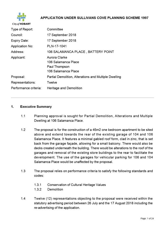
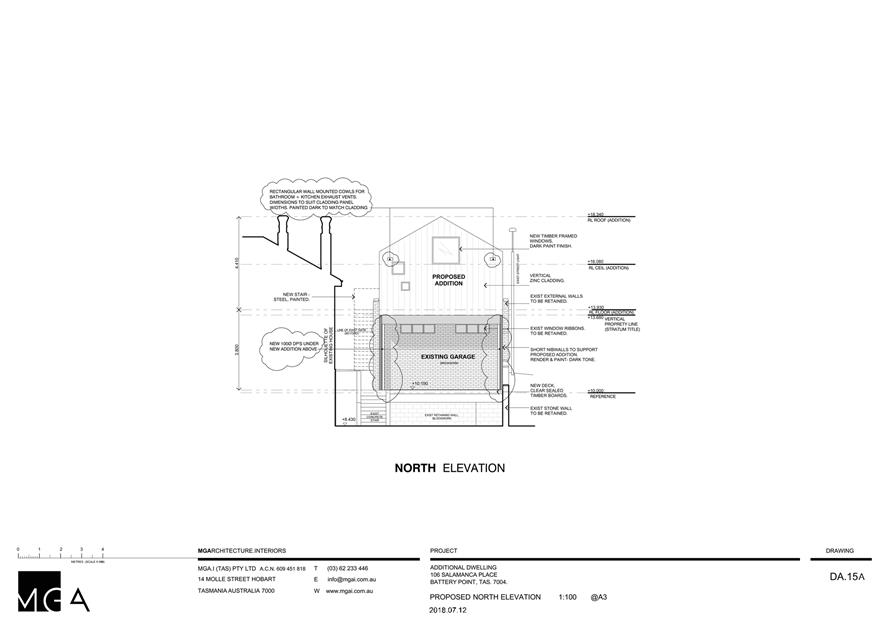
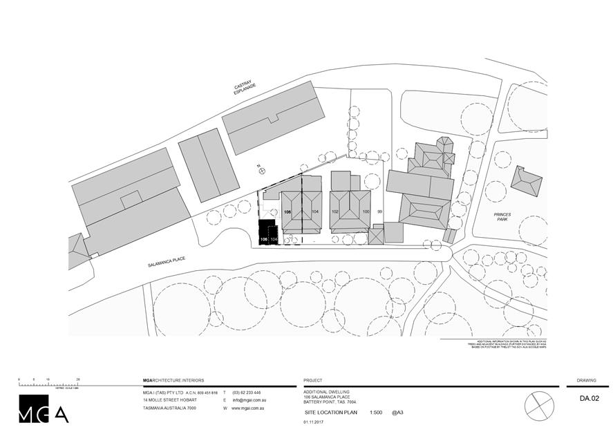
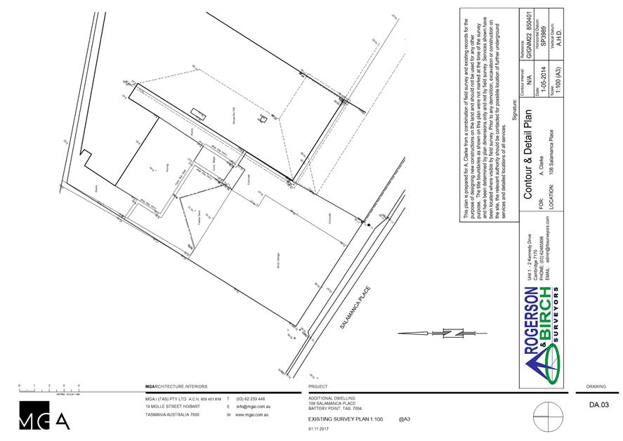
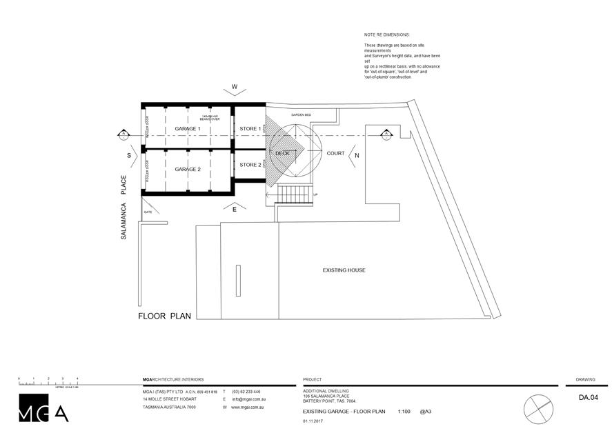
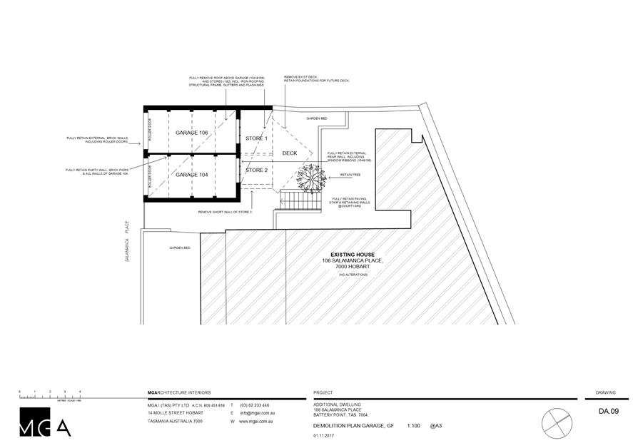
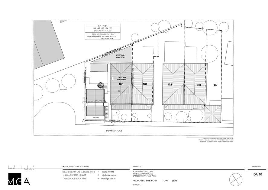
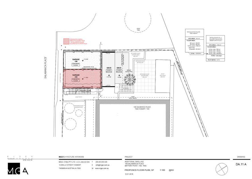
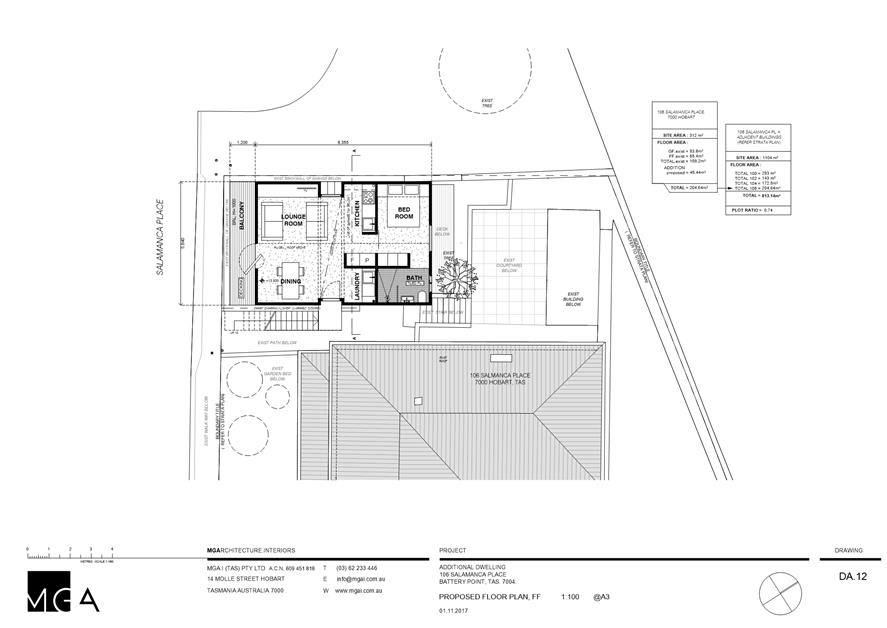
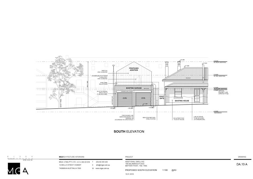
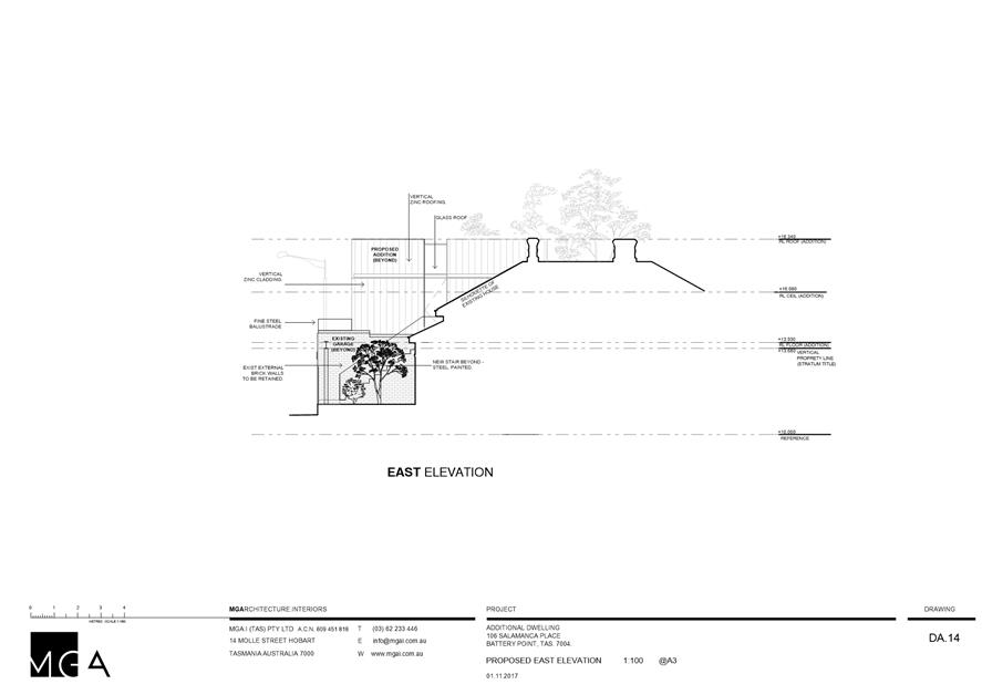
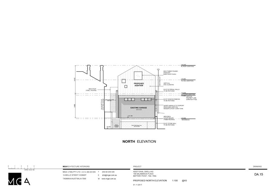
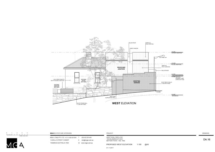
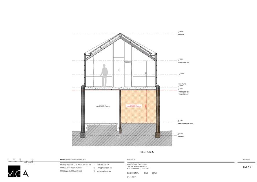
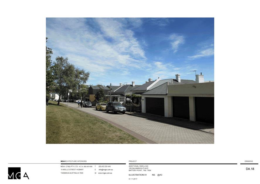
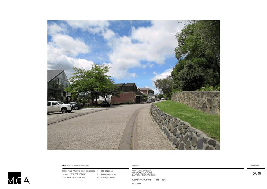
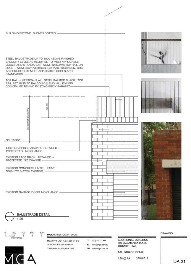
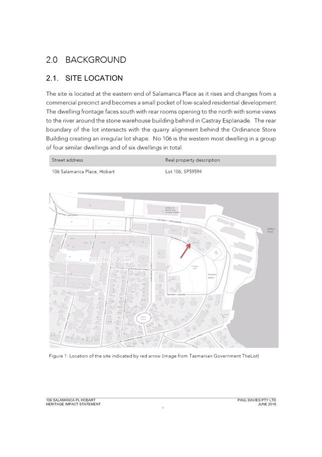
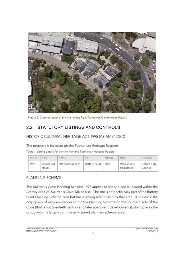
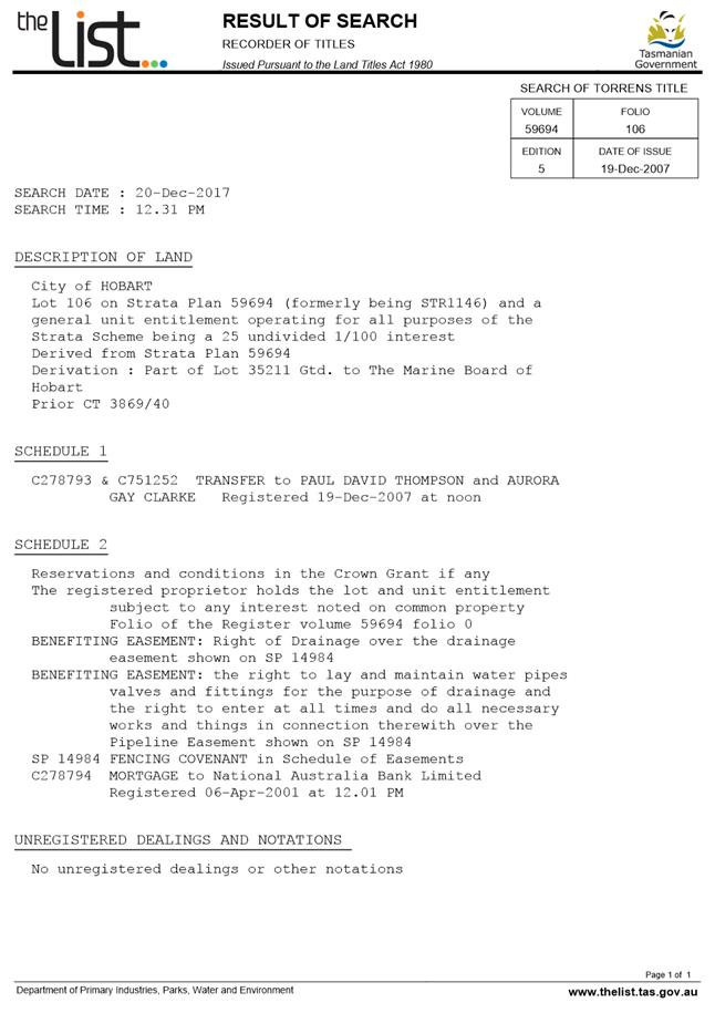
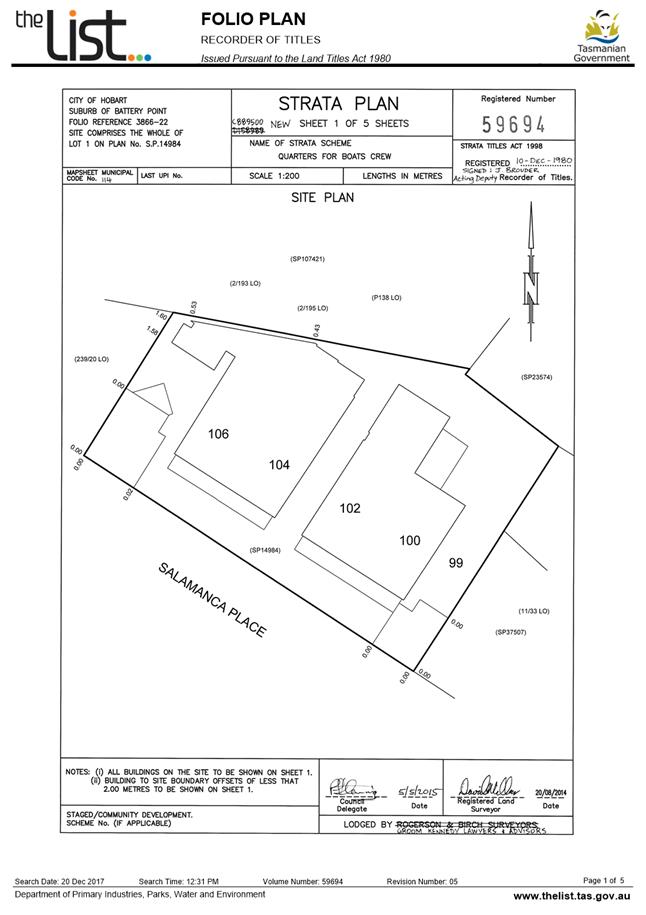
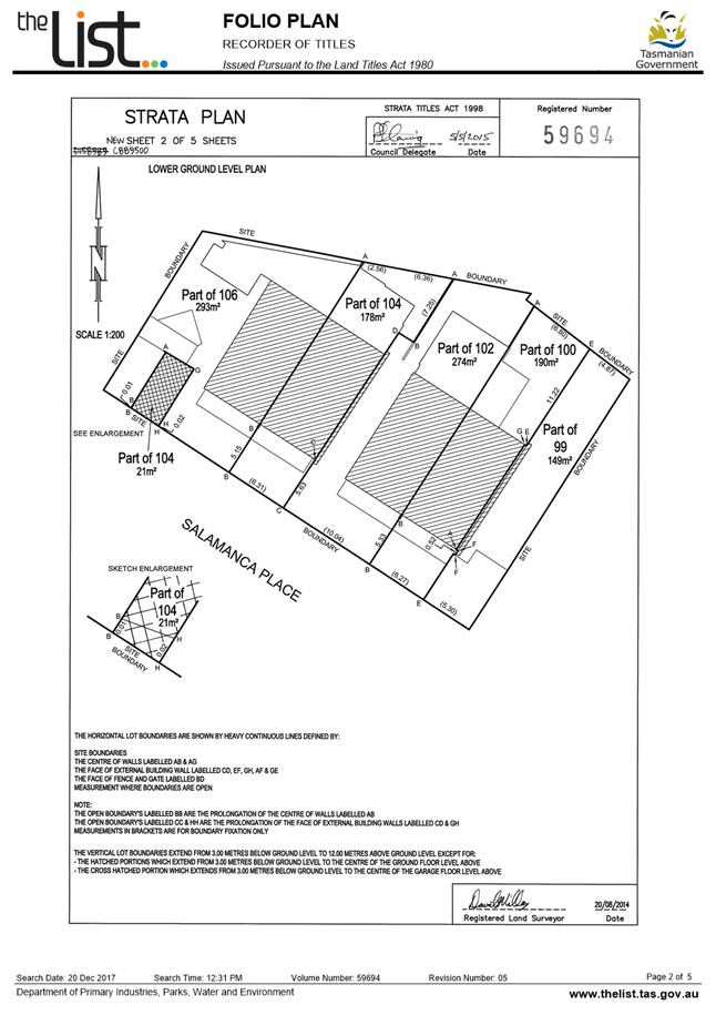
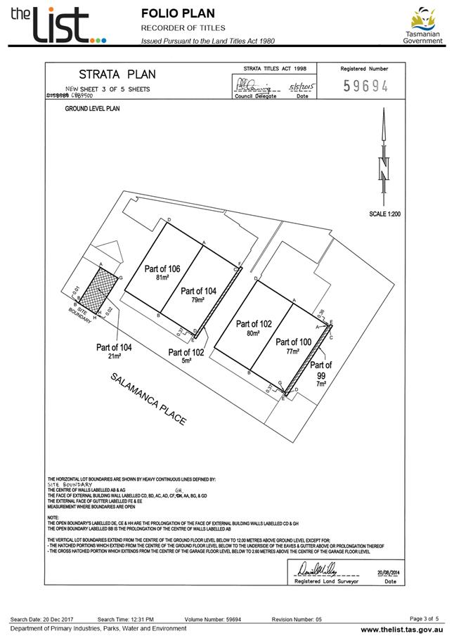
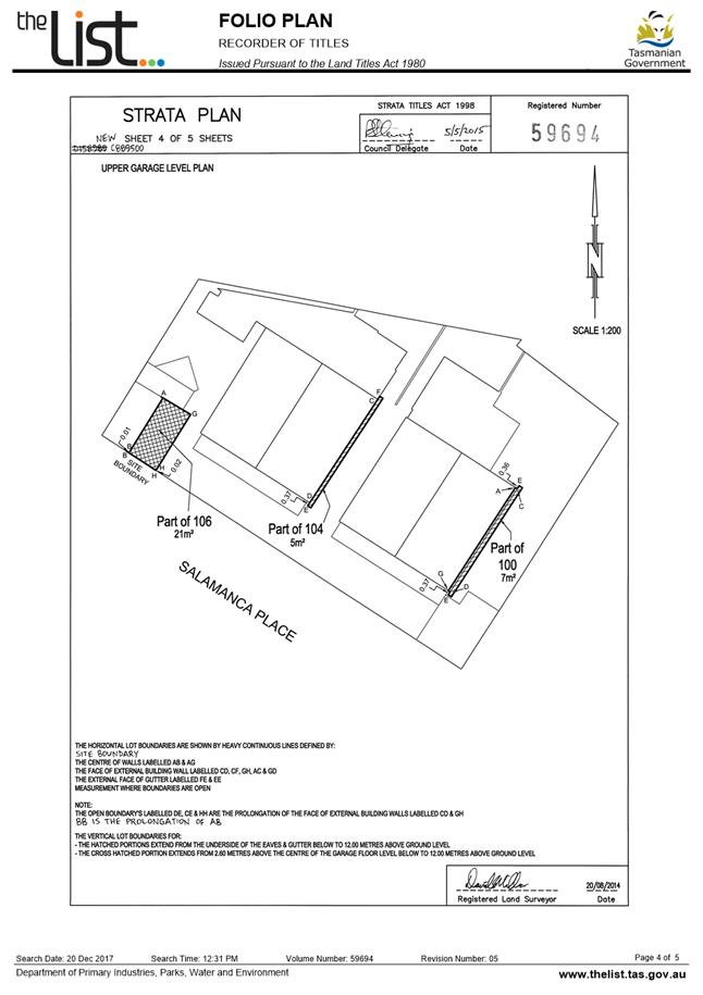
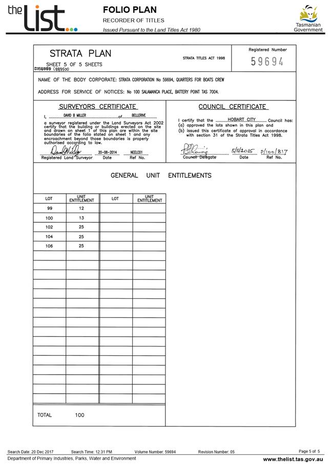
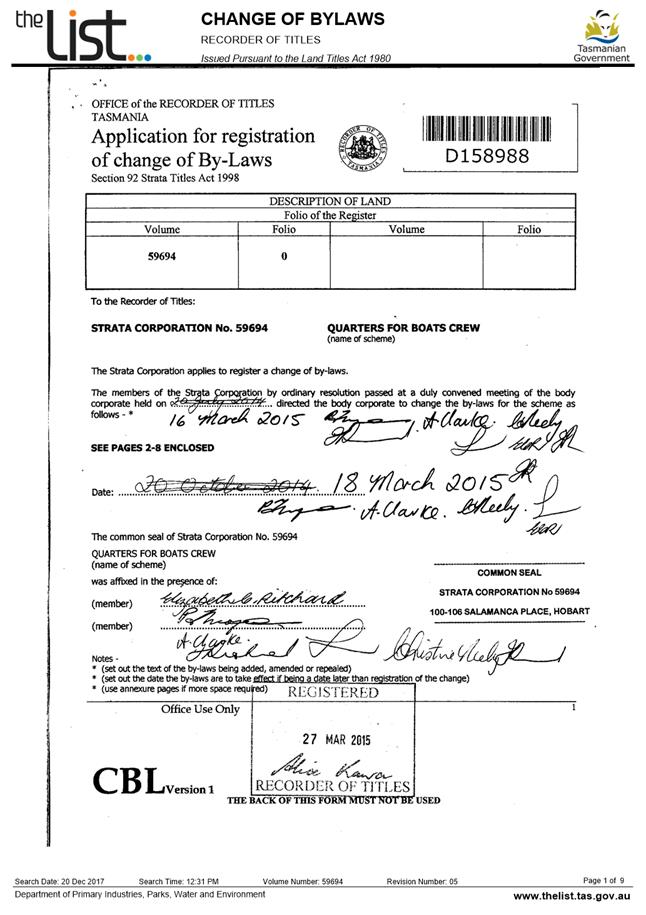
7.1.1 106 Salamanca Place, Battery Point - Partial Demolition, Alterations and Multiple Dwelling - PLN-17-1041
Memorandum of the Manager Development Appraisal of 19 February 2019 and attachments.
Delegation: Council
|
Item No. 7.1.1 |
Agenda (Open Portion) City Planning Committee Meeting |
Page 9 |
|
|
25/2/2019 |
|
Memorandum: City Planning Committee
106 Salamanca Place, Battery Point - Partial Demolition, Alterations and Multiple Dwelling - PLN-17-1041
Planning application PLN-17-1041 for partial demolition, alterations and multiple dwelling at 106 Salamanca Place, Battery Point was previously considered by the Council’s City Planning Committee at its meeting of 10 September 2018. The officer recommendation of refusal was upheld by the Committee at that meeting.
At the subsequent Council meeting on 17 September 2018, the Council resolved as follows:
That application PLN-17-1041 (106 Salamanca Place, Battery Point - Partial Demolition, Alterations and Multiple Dwelling) be deferred at the request of the applicant.
After consideration of their proposal, the applicant has now requested that the application be finally determined. There have been no amendments made to the proposal. Accordingly, the officer assessment and recommendation for refusal remains unchanged, and is included as Attachment A to this memorandum.
Also, the document titled ‘106 Salamanca Place Heritage Impact Assessment June 2018’ submitted by the applicant in support of the proposal, and which was inadvertently left out of the documentation previously presented to Elected Members, is included within Attachment B (CPC Agenda Documents) to this memorandum.
An extension of time has been granted until 4 March 2019.
|
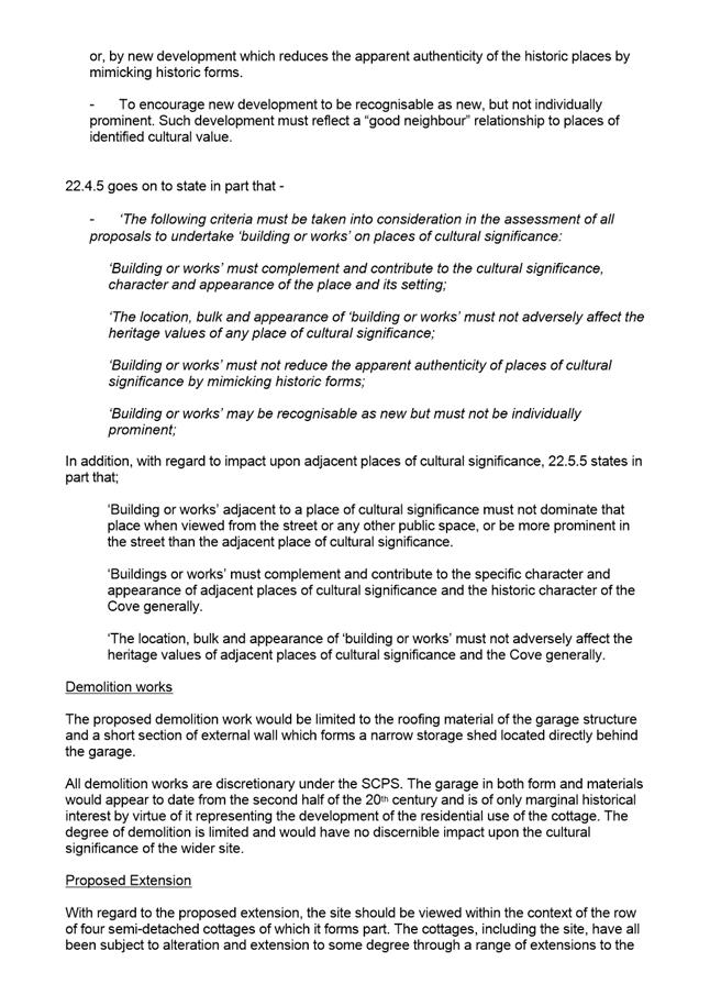
That pursuant to the Sullivans Cove Planning Scheme 1997, the Council refuse the application for partial demolition, alterations and multiple dwelling at 106 Salamanca Place, Battery Point for the following reasons: 1. The proposed development would fail to complement and contribute to the cultural significance, character and appearance of this place of cultural significance or to the wider group of cottages in which it stands, also identified as places of cultural significance, contrary to 22.4.5 and 22.5.5 of the Sullivans Cove Planning Scheme 1997. 2. The proposed development, by virtue of its location, bulk, height and form would be individually prominent both to this place of cultural significance and within the wider group of cottages in which it stands, also identified as places of cultural significance, contrary to 22.4.5 and 22.5.5 of the Sullivans Cove Planning Scheme 1997. 3. The proposed development, by virtue of its location, bulk and appearance would adversely affect the heritage values of this place of cultural significance and those of the wider group of cottages in which it stands, also identified as places of cultural significance, contrary to 22.4.5 and 22.5.5 of the Sullivans Cove Planning Scheme 1997.
|
As signatory to this report, I certify that, pursuant to Section 55(1) of the Local Government Act 1993, I hold no interest, as referred to in Section 49 of the Local Government Act 1993, in matters contained in this report.
|
Rohan Probert Manager Development Appraisal |
|
Date: 19 February 2019
File Reference: F19/19021
Attachment a: PLN-17-1041
- 106 SALAMANCA PLACE BATTERY POINT TAS 7004 - Planning Committee or Delegated
Report ⇩ ![]()
Attachment
b: PLN-17-1041
- 106 SALAMANCA PLACE BATTERY POINT TAS 7004 - CPC Agenda Documents ⇩ ![]()
Attachment
c: PLN-17-1041
- 106 SALAMANCA PLACE BATTERY POINT TAS 7004 - CPC Supporting Documents - Planning
Referral Officer Cultural Heritage Report ⇩ ![]()
|
Item No. 7.1.1 |
Agenda (Open Portion) City Planning Committee Meeting - 25/2/2019 |
Page 11 ATTACHMENT a |

|
Agenda (Open Portion) City Planning Committee Meeting - 25/2/2019 |
Page 35 ATTACHMENT b |
|
Item No. 7.1.1 |
Agenda (Open Portion) City Planning Committee Meeting - 25/2/2019 |
Page 55 ATTACHMENT b |
|
Item No. 7.1.1 |
Agenda (Open Portion) City Planning Committee Meeting - 25/2/2019 |
Page 57 ATTACHMENT b |
|
Item No. 7.1.1 |
Agenda (Open Portion) City Planning Committee Meeting - 25/2/2019 |
Page 58 ATTACHMENT b |

|
Item No. 7.1.1 |
Agenda (Open Portion) City Planning Committee Meeting - 25/2/2019 |
Page 112 ATTACHMENT c |

|
Agenda (Open Portion) City Planning Committee Meeting |
Page 119 |
|
|
|
25/2/2019 |
|
7.2 Applications under the Hobart Interim Planning Scheme 2015
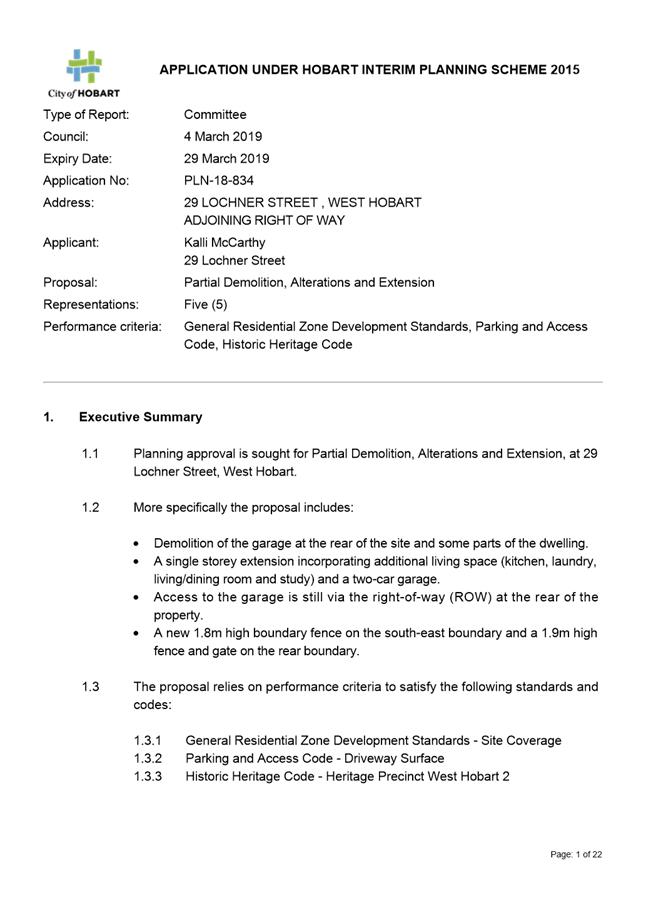
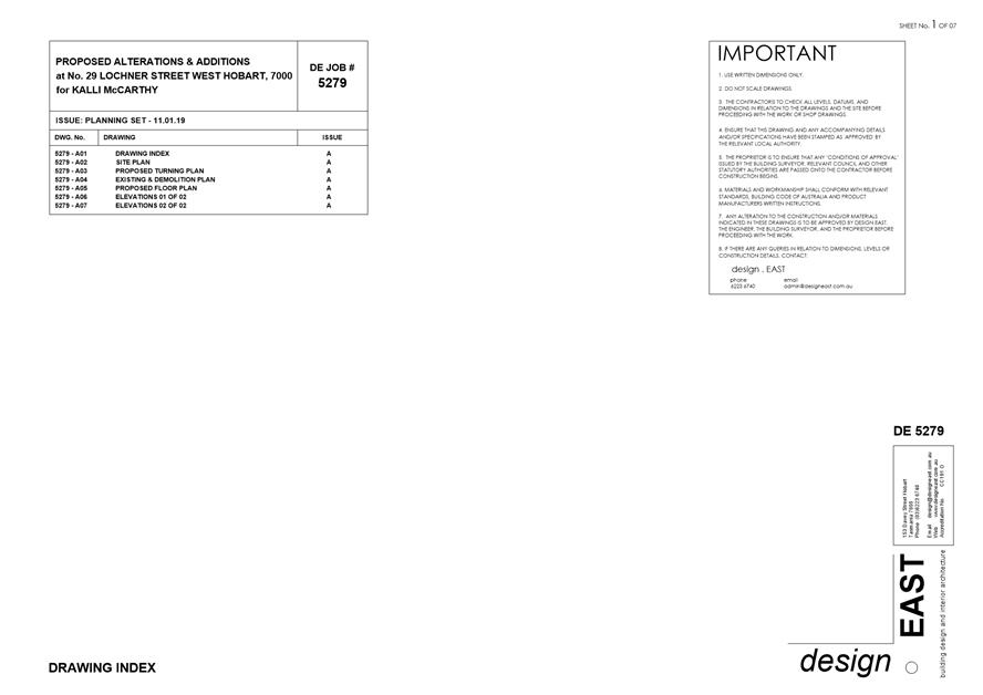
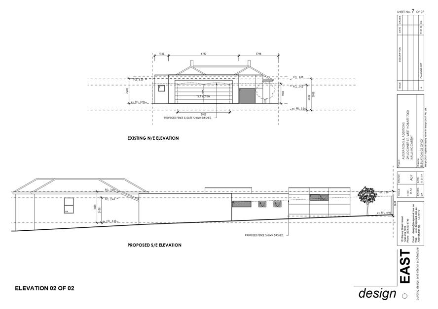
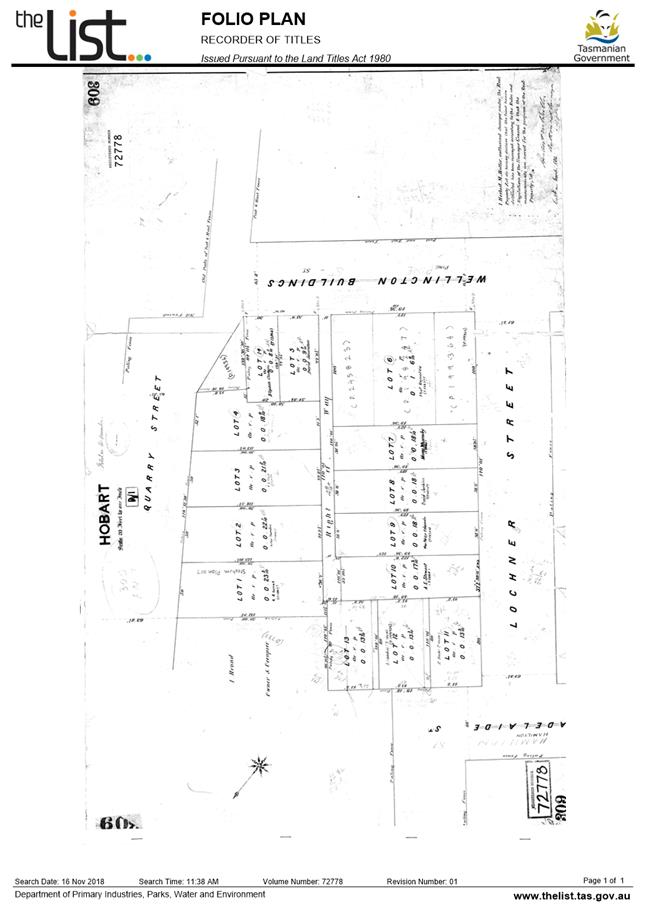
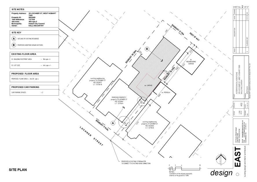
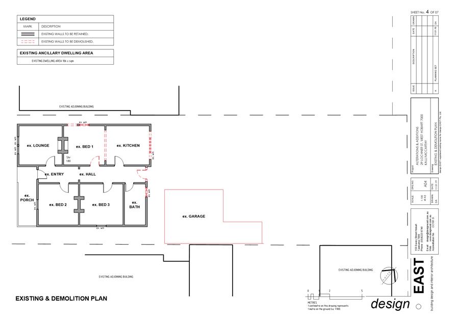
7.2.1 29 Lochner Street West Hobart and Adjoining Right Of Way - Partial Demolition, Alterations and Extension
Address: 29 Lochner Street, West Hobart and Adjoining Right of Way
Proposal: Partial Demolition, Alterations and Extensions
Expiry Date: 29 March 2019
Extension of Time: Not applicable
Author: Liz Wilson
|
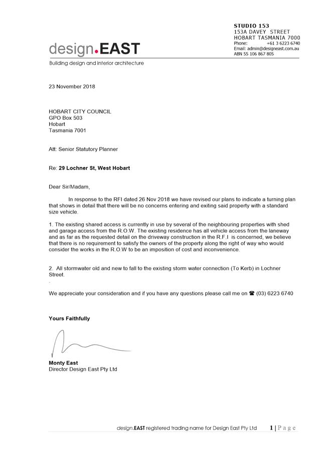
REcommendation That pursuant to the Hobart Interim Planning Scheme 2015, the Council approve the application for partial demolition, alterations and extension at 29 Lochner Street WEST HOBART and Adjoining Right of Way for the reasons outlined in the officer’s report and a permit containing the following conditions be issued:
GEN
The use and/or development must be substantially in accordance with the documents and drawings that comprise PLN18834 29 LOCHNER STREET WEST HOBART TAS 7000 Final Planning Documents except where modified below.
Reason for condition
To clarify the scope of the permit.
PLN s1
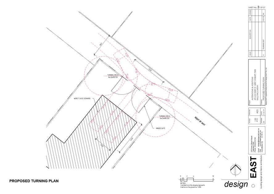
The turning area must achieve a minimum dimension as shown on plan A03.
Reason for condition
To ensure that the development meets the minimum requirement under the Parking and Access Code of the Hobart Interim Planning Scheme 2015.
ENG sw1
All stormwater from the proposed development (including but not limited to: roofed areas, ag drains, retaining wall ag drains and impervious surfaces such as driveways and paved areas) must be drained to the Council’s stormwater infrastructure prior to first occupation or commencement of use (whichever occurs first).
Reason for condition
To ensure that stormwater from the site will be discharged to a suitable Council approved outlet.
ENG sw4
If a new stormwater connection is required for draining stormwater from the right of way, this connection must be constructed and existing abandoned connections sealed by the Council at the owner’s expense, prior to the first occupation.
If a new stormwater connection is required for draining stormwater from the right of way, detailed engineering drawings must be submitted and approved, prior to commencement of work. The detailed engineering drawings must include: 1. The location of the proposed connection; and 2. The size of the connection appropriate to satisfy the needs of the development.
All work required by this condition must be undertaken in accordance with the approved detailed engineering drawings.
Advice: · The applicant is advised to submit detailed design drawings via a Council City Infrastructure Division application for a new stormwater connection. If detailed design to satisfy this condition is submitted via the planning condition endorsement process there may be fees associated with the assessment, and once approved the applicant will still need to submit an application for a new stormwater connection with Council City Infrastructure Division.
· Where building / plumbing approval is also required, it is recommended that documentation to satisfy this condition is submitted well before submitting documentation for building/plumbing approval. Failure to address planning condition requirements prior to submitting for building/plumbing approval may result in unexpected delays.
Reason for condition
To ensure the site is drained adequately.
ENG 4
The access driveway within the property boundary, the vehicle turning area within the right of way, and parking spaces approved by this permit must be constructed to a sealed standard (spray seal, asphalt, concrete, pavers or equivalent Council approved) and surface drained to the Council's stormwater infrastructure prior to the commencement of use.
Reason for condition
To ensure the safety of users of the access driveway and parking module, and that it does not detract from the amenity of users, adjoining occupiers or the environment by preventing dust, mud and sediment transport.
ENG 1
Any damage to council infrastructure resulting from the implementation of this permit, must, at the discretion of the Council: 1. Be met by the owner by way of reimbursement (cost of repair and reinstatement to be paid by the owner to the Council); or
2. Be repaired and reinstated by the owner to the satisfaction of the Council.
A photographic record of the Council's infrastructure adjacent to the subject site must be provided to the Council prior to any commencement of works.
A photographic record of the Council’s infrastructure (e.g. existing property service connection points, roads, buildings, stormwater, footpaths, driveway crossovers and nature strips, including if any, preexisting damage) will be relied upon to establish the extent of damage caused to the Council’s infrastructure during construction. In the event that the owner/developer fails to provide to the Council a photographic record of the Council’s infrastructure, then any damage to the Council's infrastructure found on completion of works will be deemed to be the responsibility of the owner.
Reason for condition
To ensure that any of the Council's infrastructure and/or siterelated service connections affected by the proposal will be altered and/or reinstated at the owner’s full cost.
ENV 1
Sediment and erosion control measures sufficient to prevent sediment from leaving the site must be installed prior to any disturbance of the site, and maintained until all areas of disturbance have been stabilized or revegetated.
Advice:
For further guidance in preparing a Soil and Water Management Plan – in accordance with Fact sheet 3 Derwent Estuary Program click here.
Reason for condition
To avoid the sedimentation of roads, drains, natural watercourses, Council land that could be caused by erosion and runoff from the development, and to comply with relevant State legislation.
ADVICE
The following advice is provided to you to assist in the implementation of the planning permit that has been issued subject to the conditions above. The advice is not exhaustive and you must inform yourself of any other legislation, bylaws, regulations, codes or standards that will apply to your development under which you may need to obtain an approval. Visit the Council's website for further information.
Prior to any commencement of work on the site or commencement of use the following additional permits/approval may be required from the Hobart City Council.
BUILDING PERMIT
You may need building approval in accordance with the Building Act 2016. Click here for more information.
This is a Discretionary Planning Permit issued in accordance with section 57 of the Land Use Planning and Approvals Act 1993.
PLUMBING PERMIT
You may need plumbing approval in accordance with the Building Act 2016, Building Regulations 2016 and the National Construction Code. Click here for more information.
GENERAL EXEMPTION (TEMPORARY) PARKING PERMITS
You may qualify for a General Exemption permit for construction vehicles (e.g. residential zones). Click here for more information.
RIGHT OF WAY
The private right of way must not be reduced, restricted or impeded in any way, and all beneficiaries must have complete and unrestricted access at all times.
You should inform yourself as to your rights and responsibilities in respect to the private right of way particularly reducing, restricting or impeding the right during and after construction.
WORK PLACE HEALTH AND SAFETY
Appropriate occupational health and safety measures must be employed during the works to minimise direct human exposure to potentiallycontaminated soil, water, dust and vapours. Click here for more information.
WASTE DISPOSAL
It is recommended that the developer liaise with the Council’s Cleansing and Solid Waste Unit regarding reducing, reusing and recycling materials associated with demolition on the site to minimise solid waste being directed to landfill.
Further information regarding waste disposal can also be found on the Council’s website.
FEES AND CHARGES
Click here for information on the Council's fees and charges.
DIAL BEFORE YOU DIG
Click here for dial before you dig information.
|
Attachment a: PLN-18-834
- 29 LOCHNER STREET WEST HOBART TAS 7000 - Planning Committee or Delegated
Report ⇩ ![]()
Attachment
b: PLN-18-834
- 29 LOCHNER STREET WEST HOBART & ADJOINING RIGHT OF WAY TAS 7000 - (CPC
Agenda Documents) ⇩ ![]()
Attachment
c: PLN-18-834
- 29 LOCHNER STREET WEST HOBART & ADJOINING RIGHT OF WAY TAS 7000 -
(Planning Referral Officer Cultural Heritage Report) ⇩ ![]()
|
Item No. 7.2.1 |
Agenda (Open Portion) City Planning Committee Meeting - 25/2/2019 |
Page 125 ATTACHMENT a |
|
Agenda (Open Portion) City Planning Committee Meeting - 25/2/2019 |
Page 147 ATTACHMENT b |
|
Item No. 7.2.1 |
Agenda (Open Portion) City Planning Committee Meeting - 25/2/2019 |
Page 152 ATTACHMENT b |
|
Item No. 7.2.1 |
Agenda (Open Portion) City Planning Committee Meeting - 25/2/2019 |
Page 160 ATTACHMENT c |
|
Agenda (Open Portion) City Planning Committee Meeting |
Page 163 |
|
|
|
25/2/2019 |
|
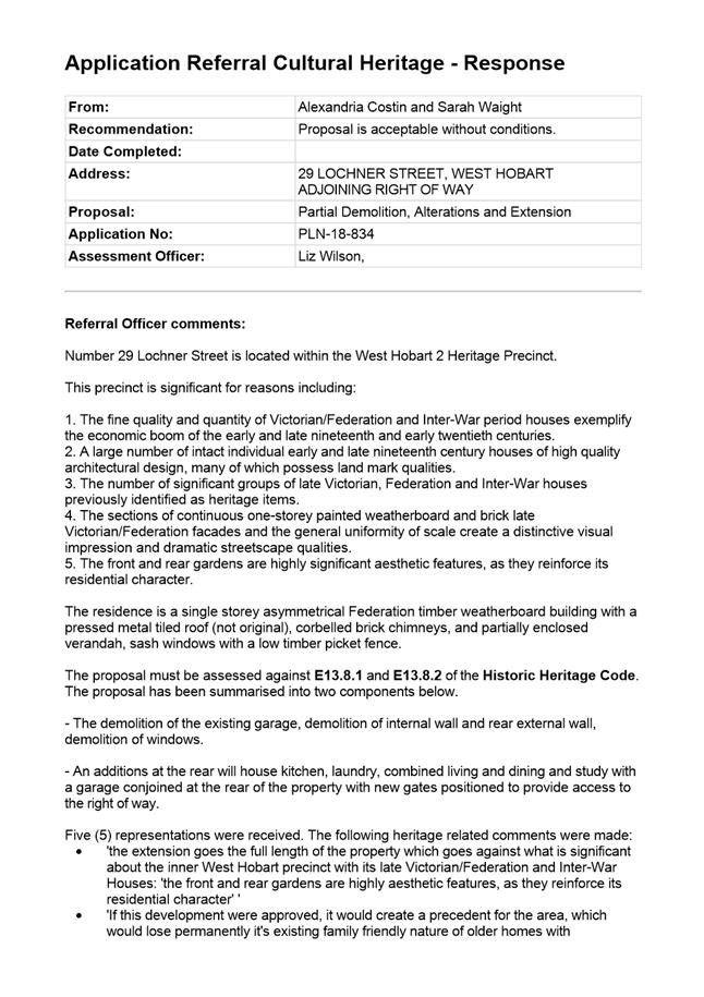
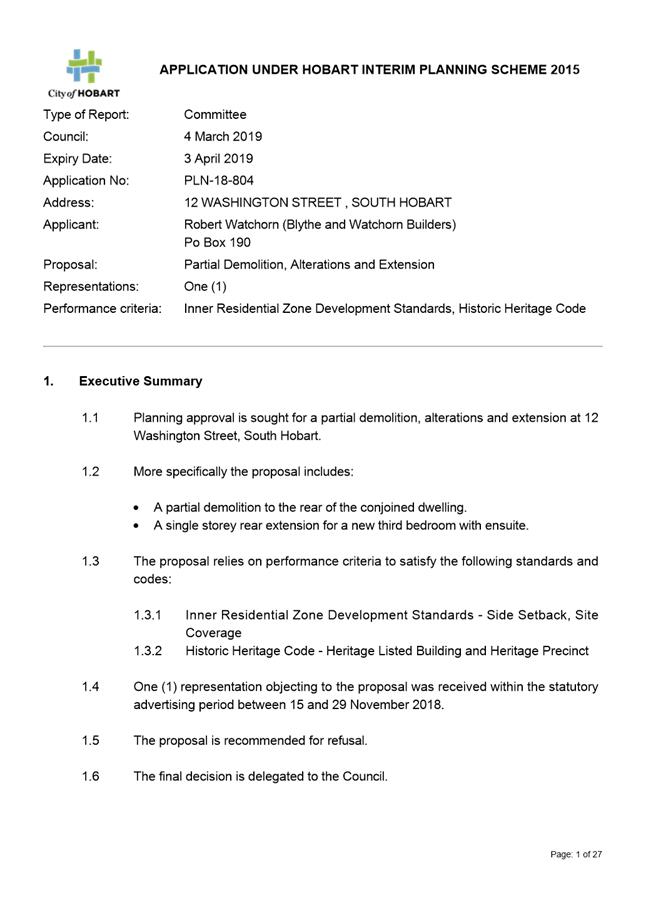
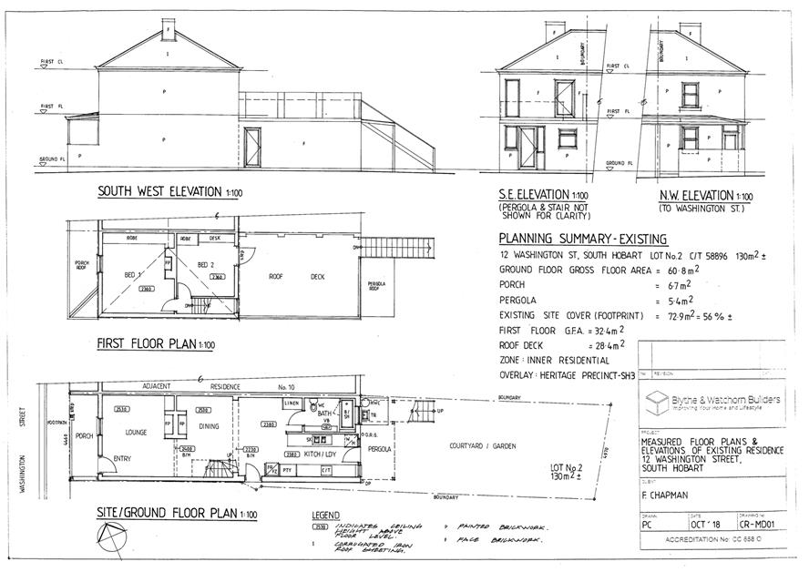
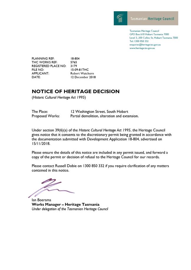
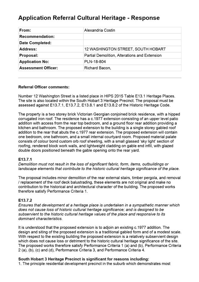
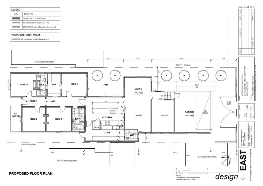
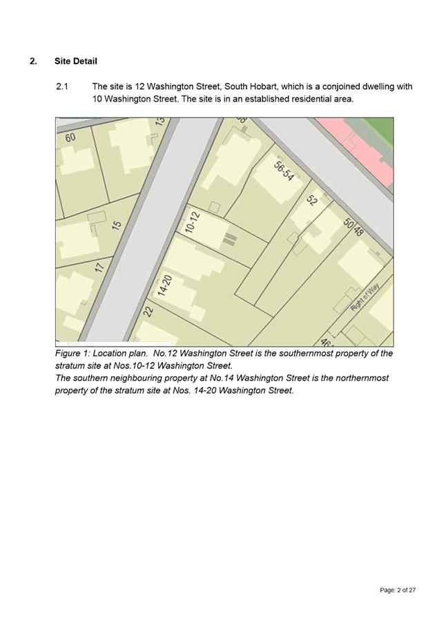
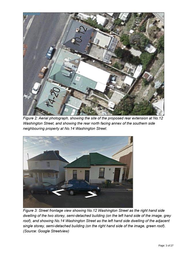
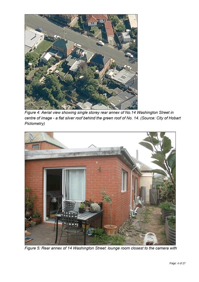
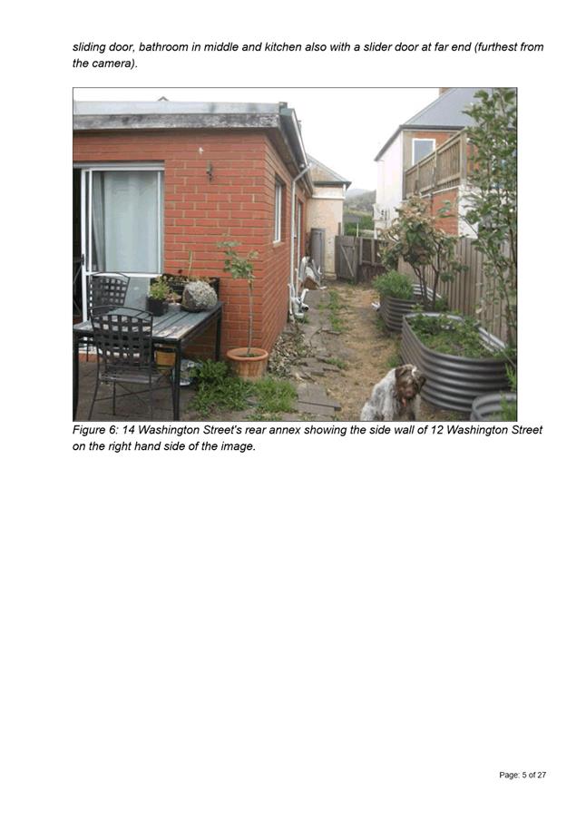
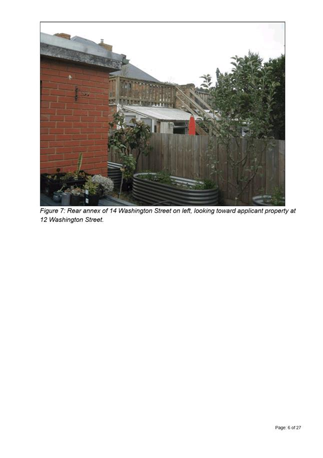
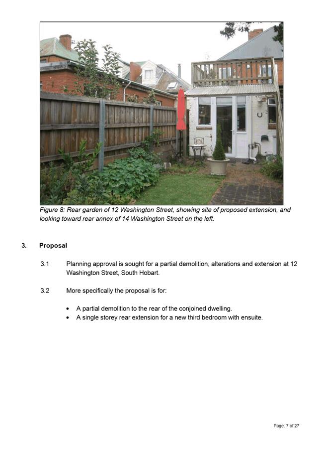
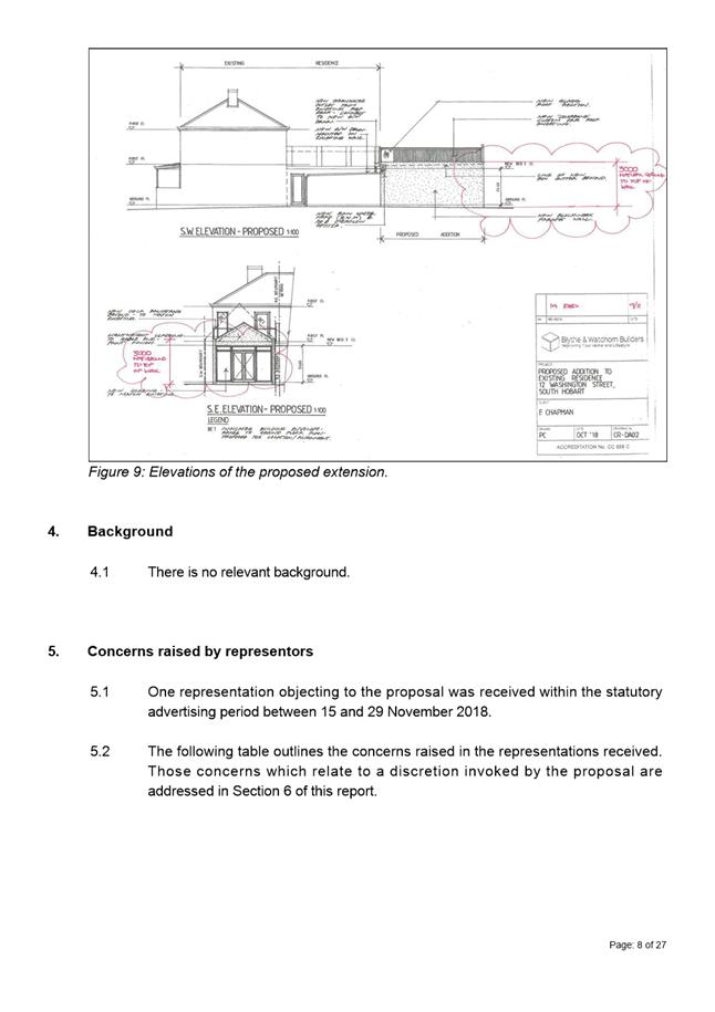
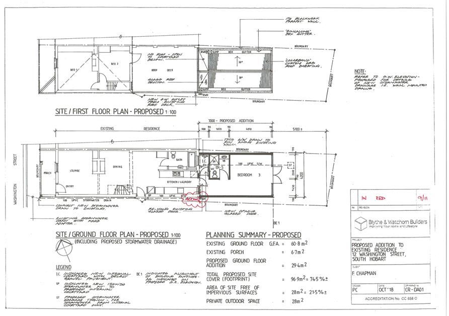
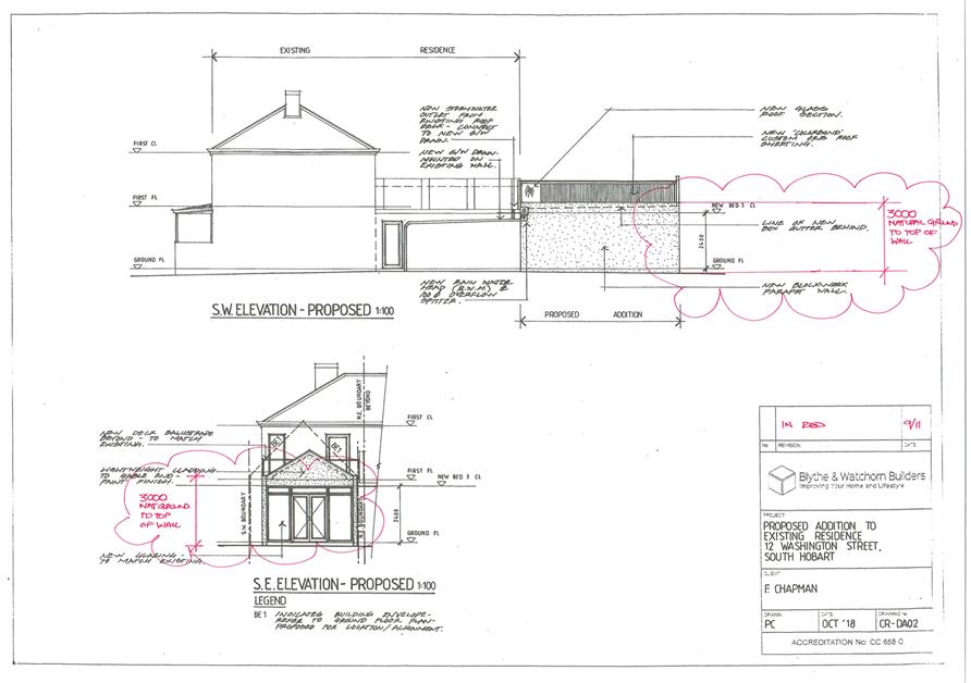
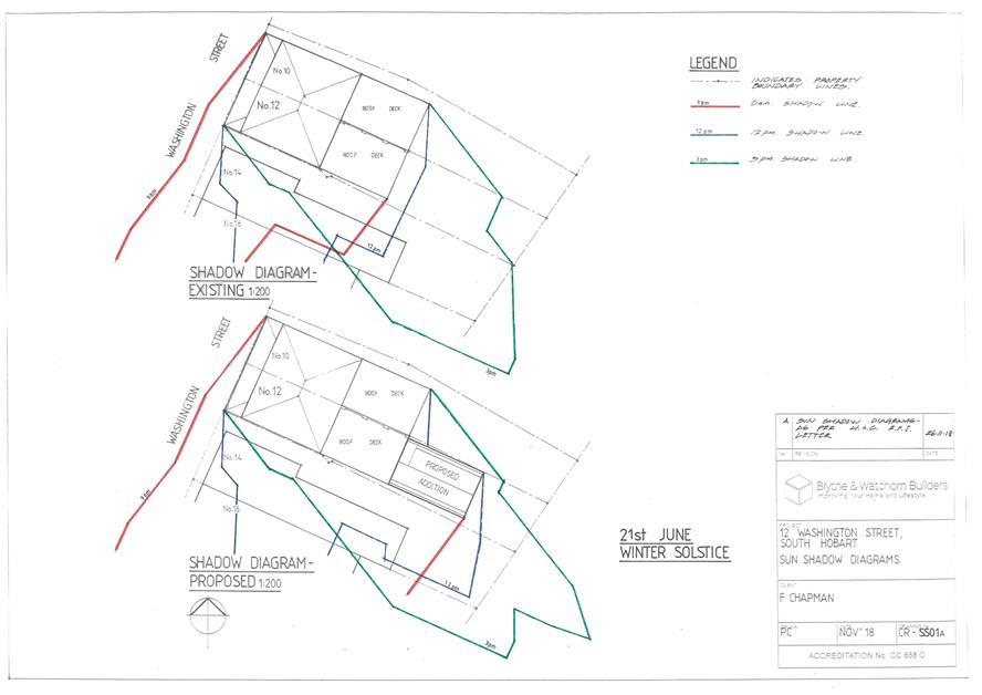
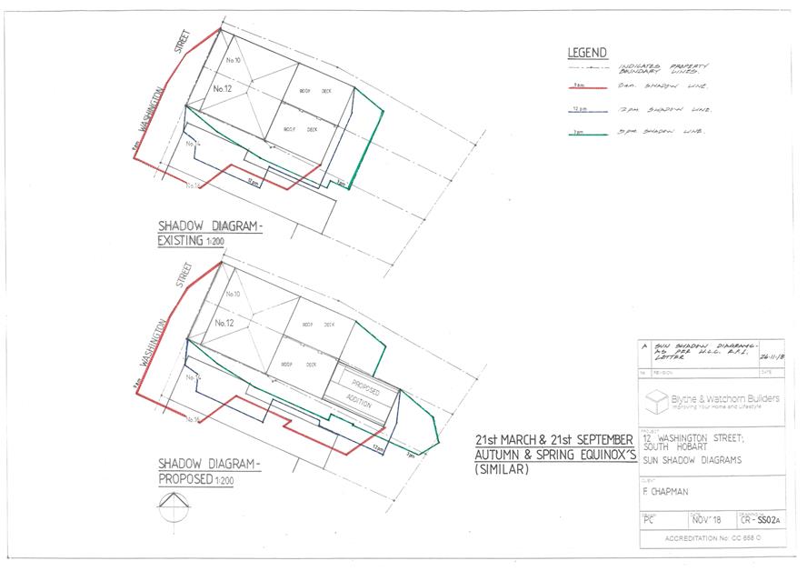
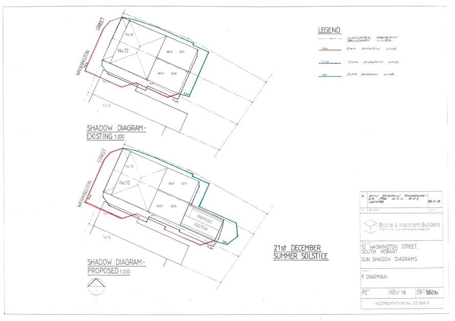
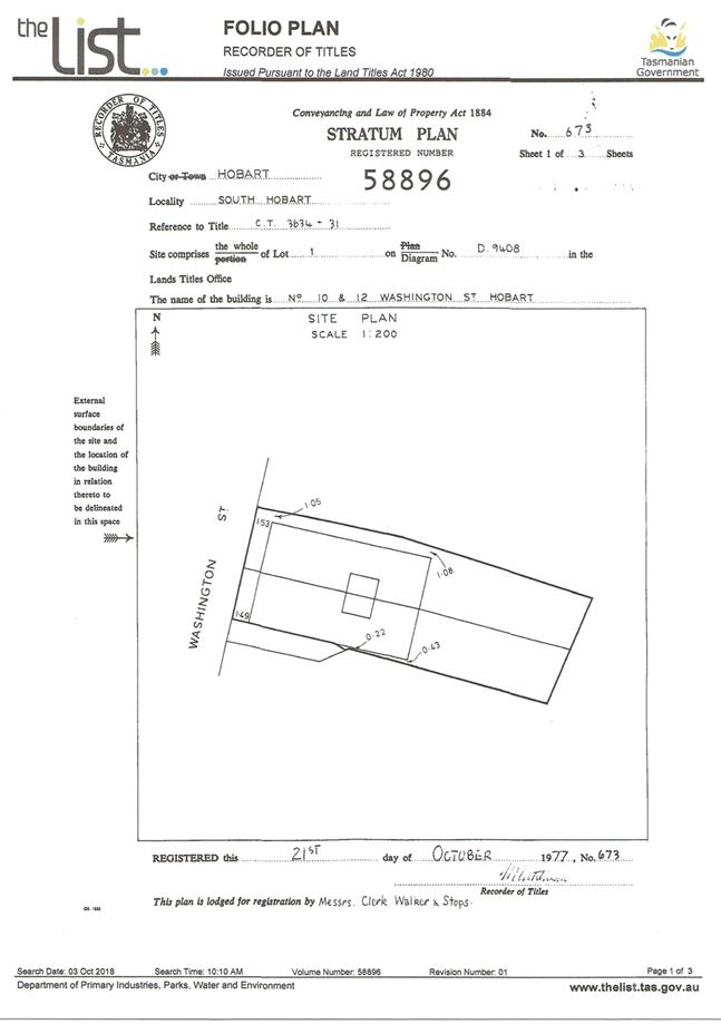
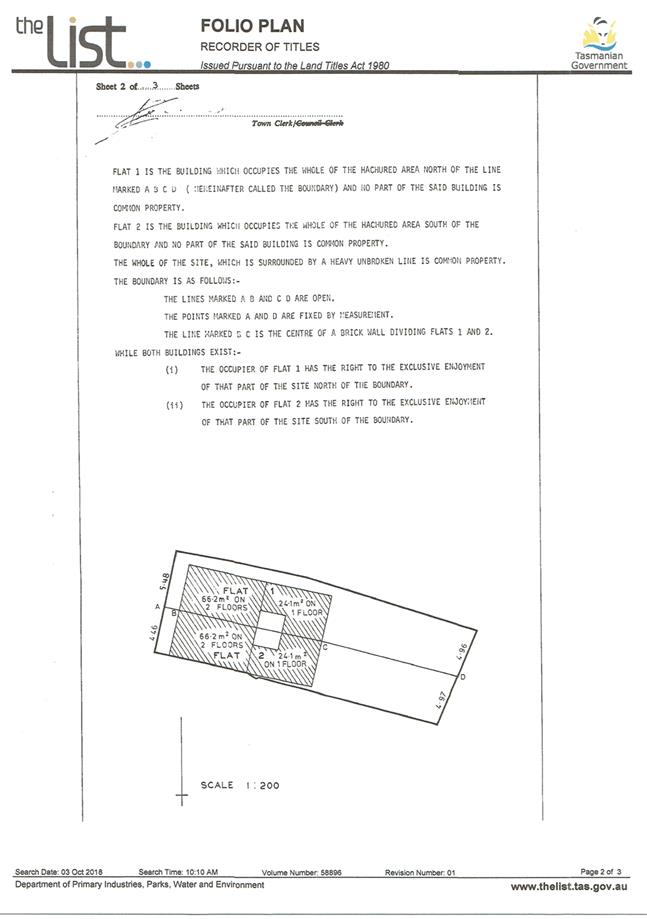
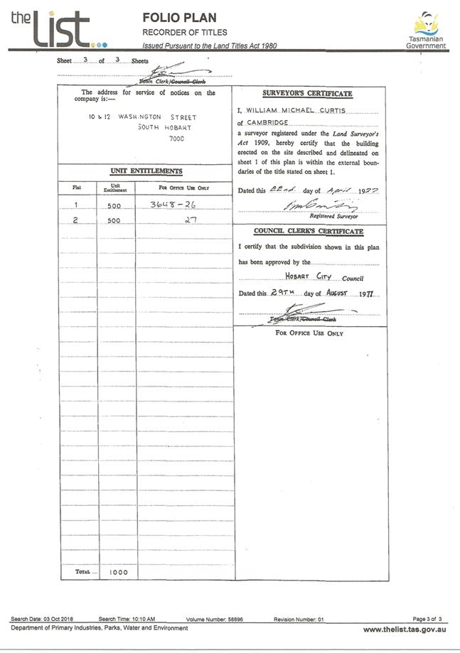
7.2.2 12 Washington Street, South Hobart - Partial Demolition, Alterations and Extension
Address: 12 Washington Street, South Hobart
Proposal: Partial Demolition, Alterations and Extension
Expiry Date: 3 April 2019
Extension of Time: Not applicable
Author: Richard Bacon
|
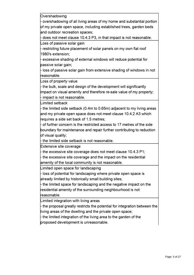
REcommendation Pursuant to the Hobart Interim Planning Scheme 2015, the Council refuse the application for a partial demolition, alterations and extension at 12 Washington Street, South Hobart TAS 7004, for the following reasons:
1. The proposal does not meet the acceptable solution or the performance criterion with respect to clause 11.4.2 A3 and P3 (i)(ii) and (iv) of the Hobart Interim Planning Scheme 2015 because it would result in an unreasonable degree of overshadowing of the rearmost habitable room and private open space of, and unreasonable visual impact on, the amenity of the neighbouring property at No.14 Washington Street. .
|
Attachment a: PLN-18-804
- 12 WASHINGTON STREET SOUTH HOBART TAS 7004 - Planning Committee or Delegated
Report ⇩ ![]()
Attachment
b: PLN-18-804
- 12 WASHINGTON STREET SOUTH HOBART TAS 7004 - CPC Agenda Documents ⇩ ![]()
Attachment
c: PLN-18-804
- 12 WASHINGTON STREET SOUTH HOBART TAS 7004 - Planning Referral Officer
Cultural Heritage Report ⇩ ![]()
|
Item No. 7.2.2 |
Agenda (Open Portion) City Planning Committee Meeting - 25/2/2019 |
Page 164 ATTACHMENT a |
|
Agenda (Open Portion) City Planning Committee Meeting - 25/2/2019 |
Page 191 ATTACHMENT b |
|
Item No. 7.2.2 |
Agenda (Open Portion) City Planning Committee Meeting - 25/2/2019 |
Page 198 ATTACHMENT b |
|
Item No. 7.2.2 |
Agenda (Open Portion) City Planning Committee Meeting - 25/2/2019 |
Page 204 ATTACHMENT c |
|
Agenda (Open Portion) City Planning Committee Meeting |
Page 206 |
|
|
|
25/2/2019 |
|
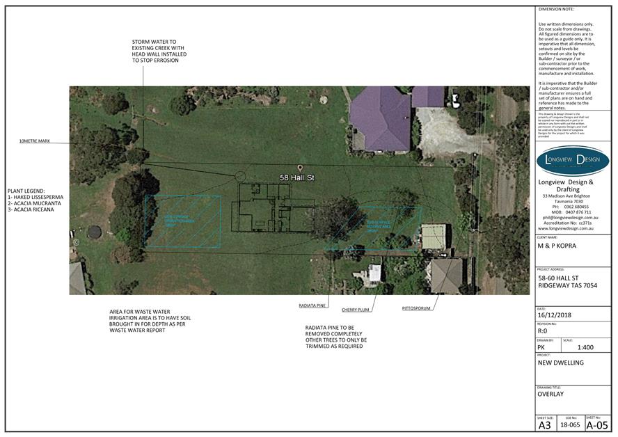
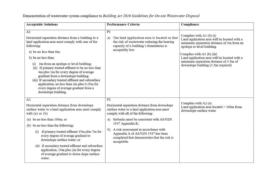
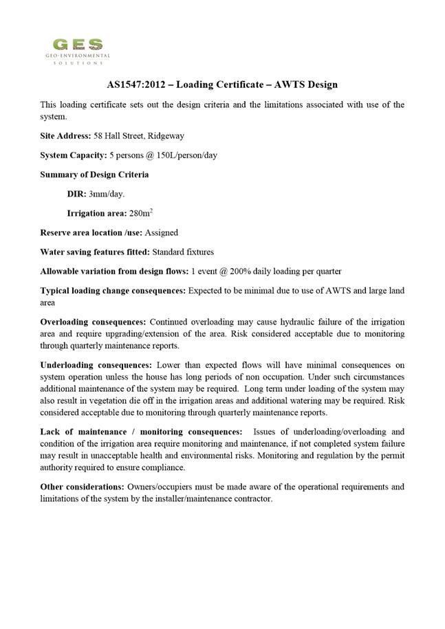
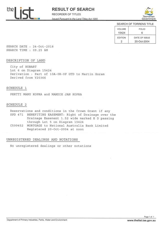
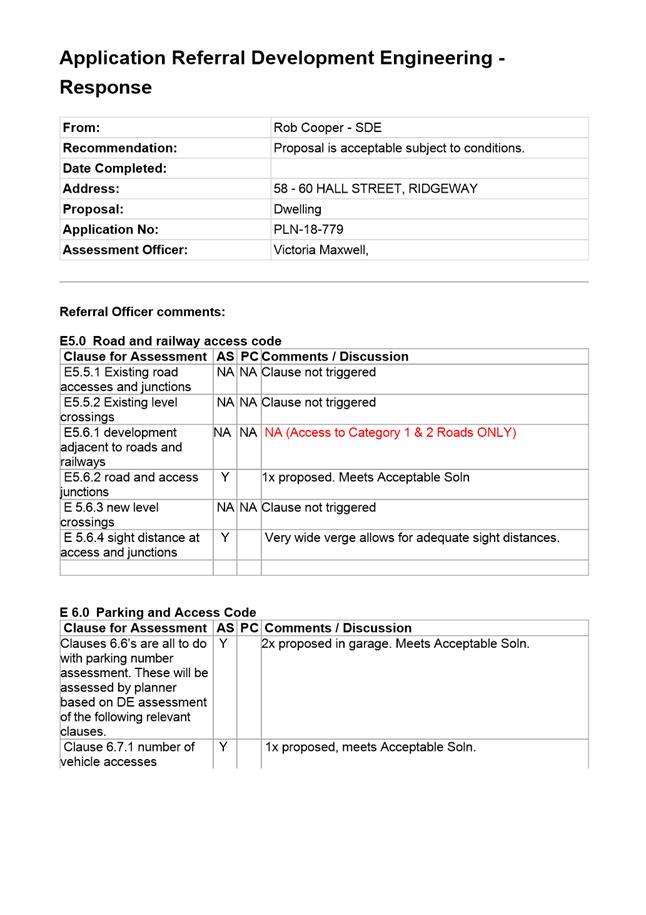
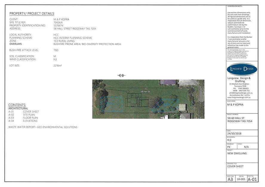
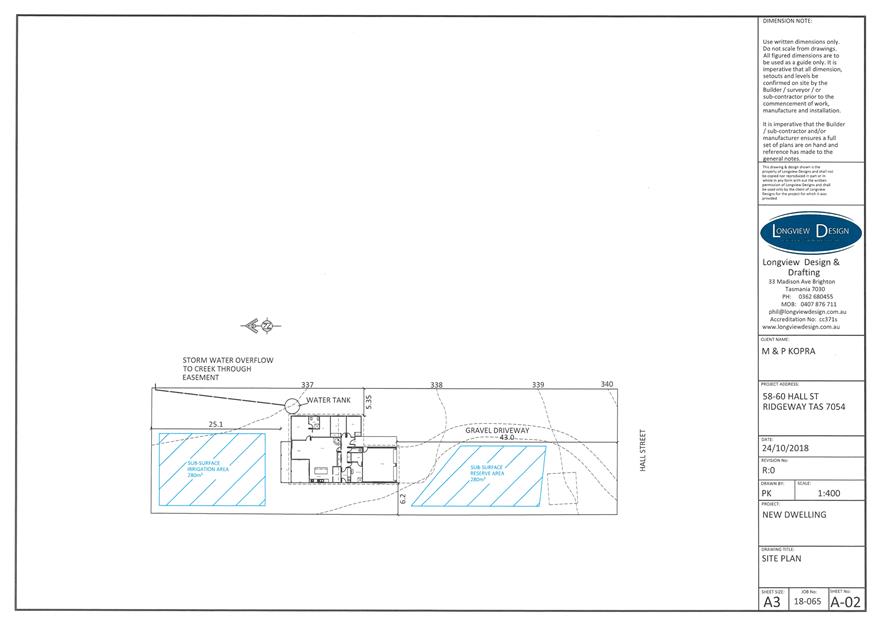
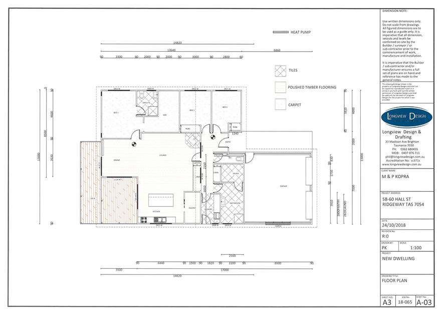
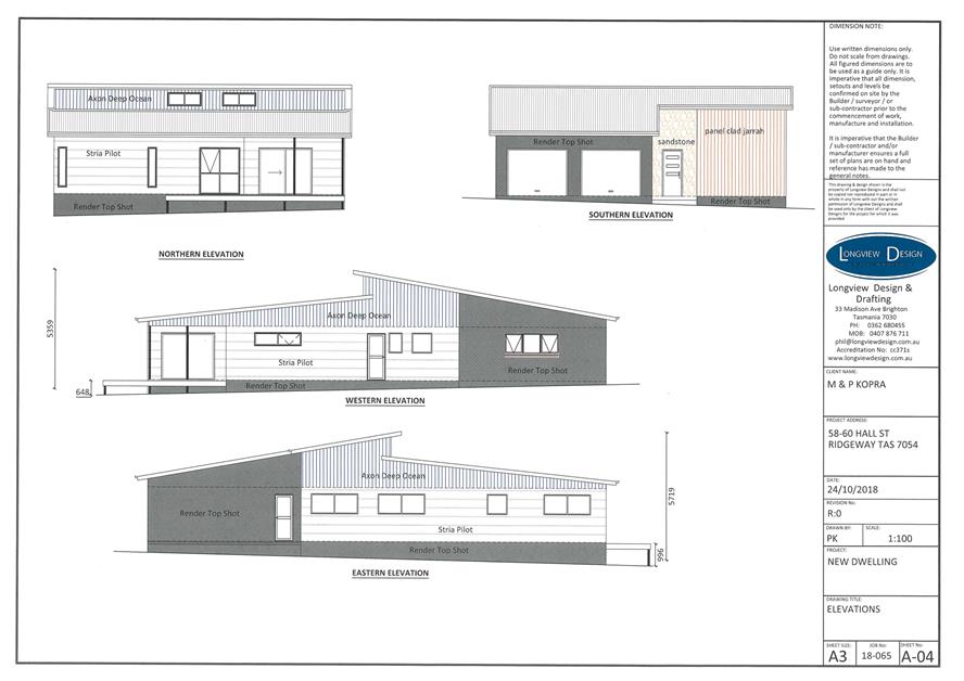
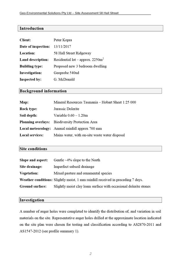
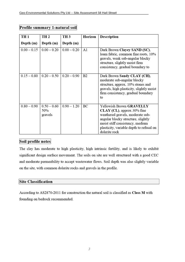
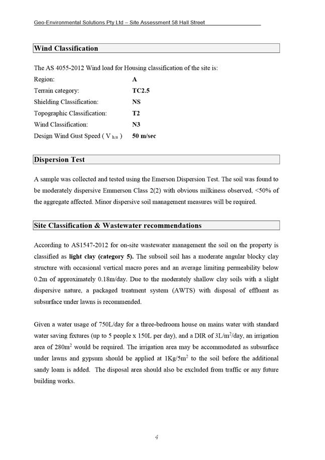
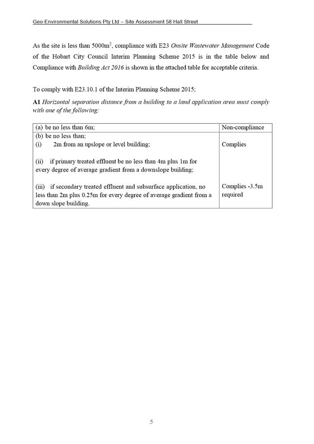
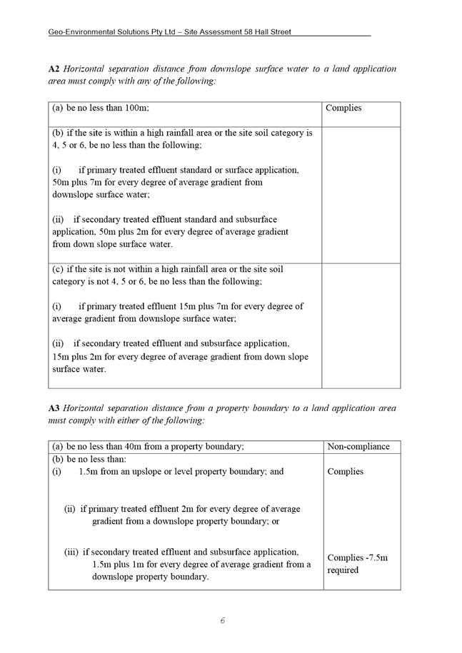
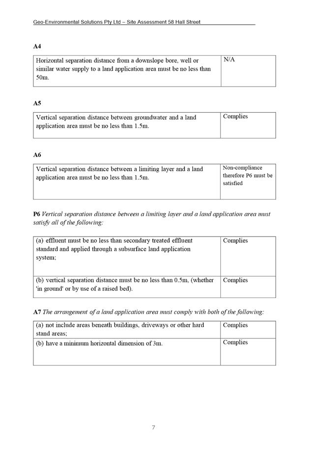
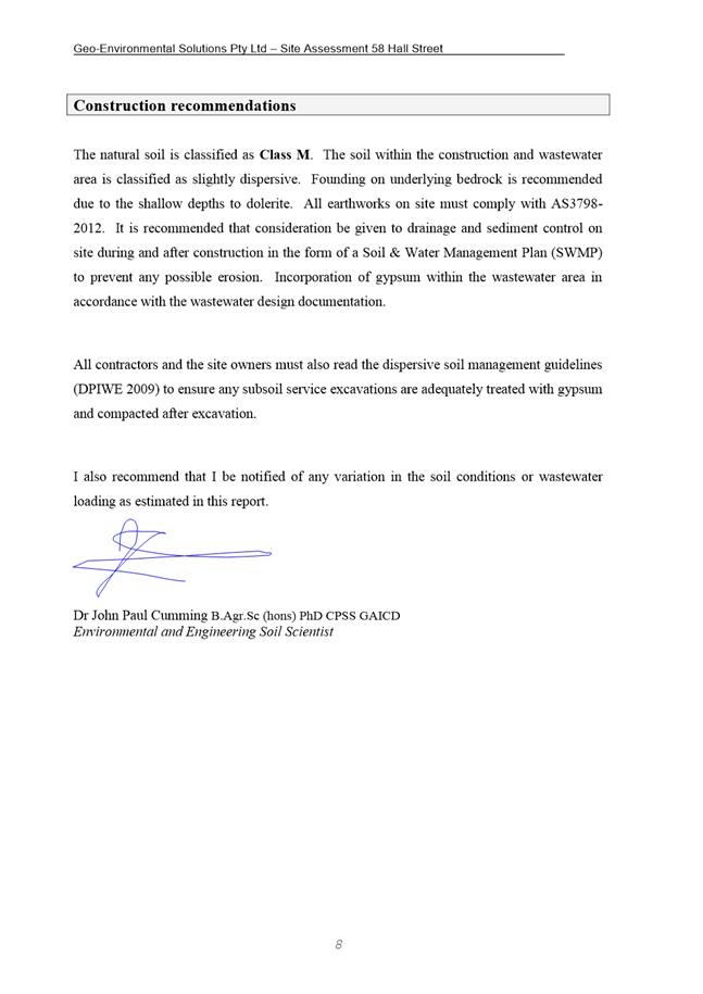
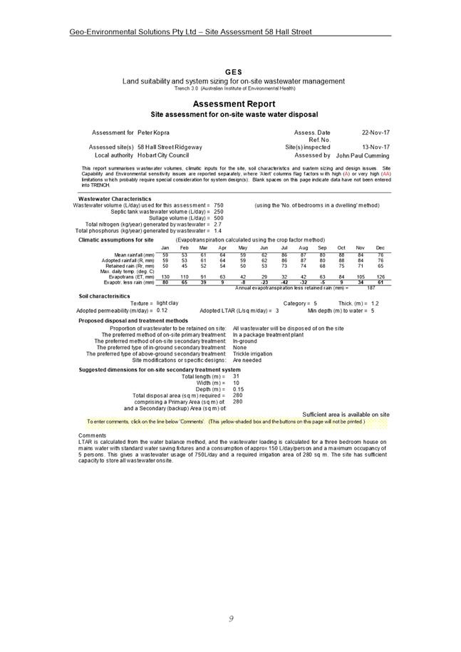
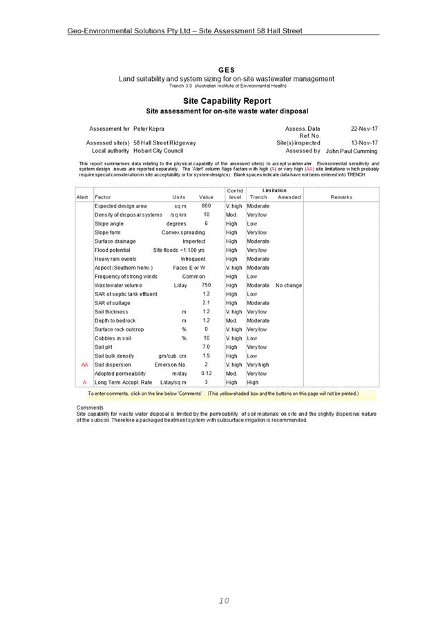
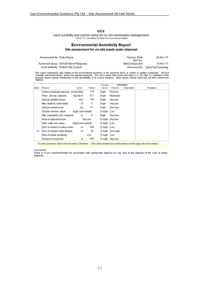
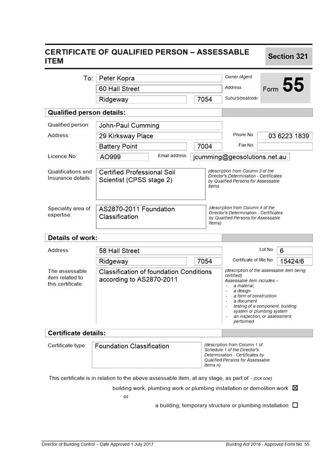
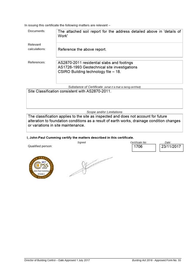
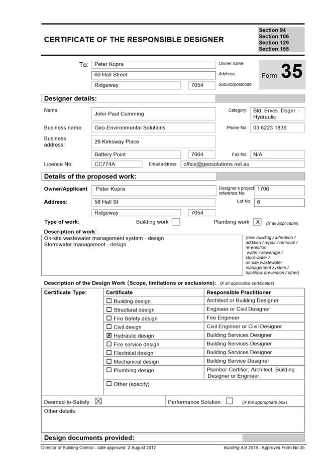
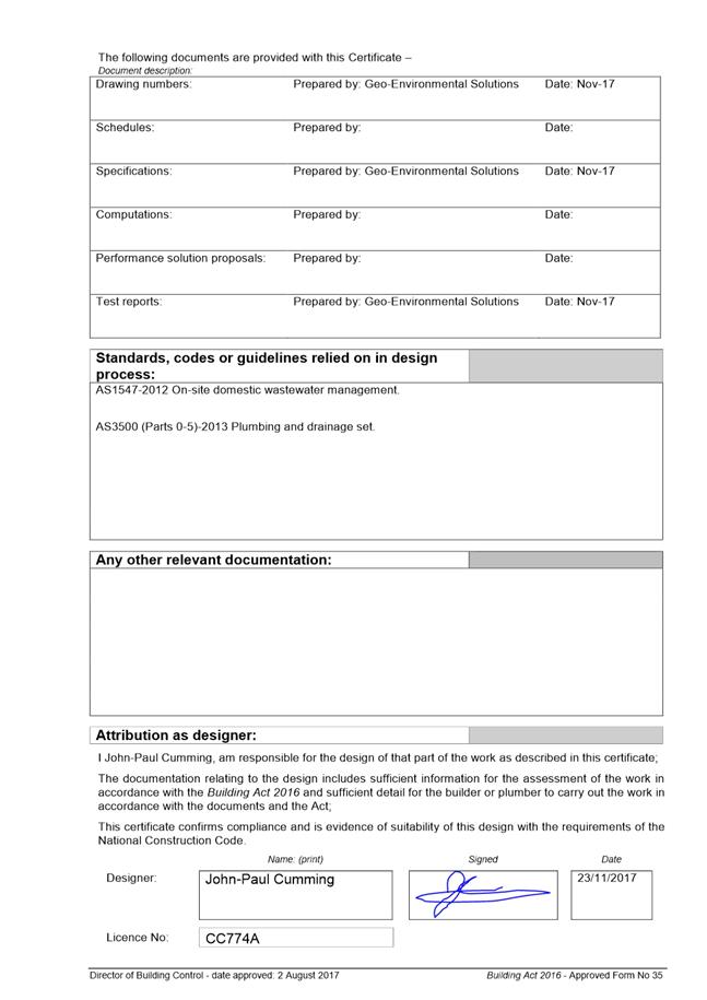
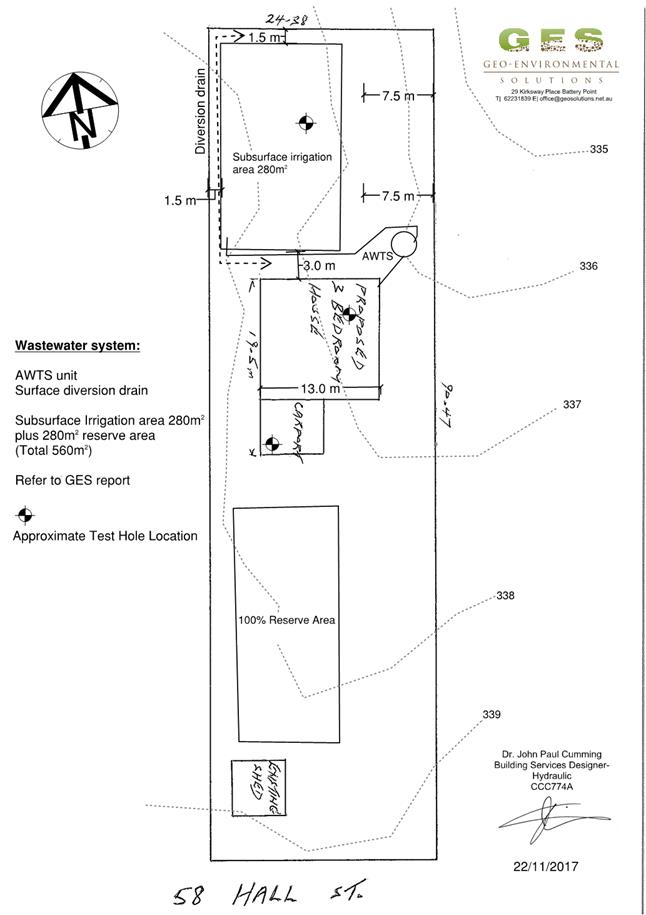
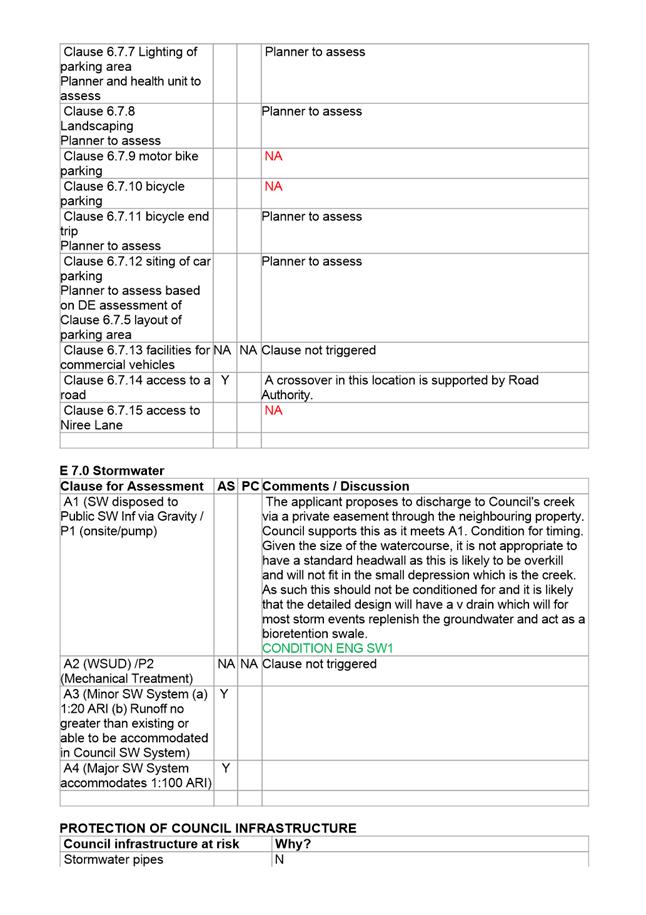
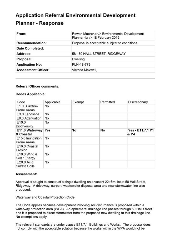
7.2.3 58-60 Hall Street, Ridgeway - Dwelling
Address: 58 – 60 Hall Street, Ridgeway
Proposal: Dwelling
Expiry Date: 10 March 2019
Extension of Time: Not applicable
Author: Victoria Maxwell
|
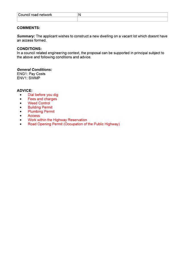
REcommendation That pursuant to the Hobart Interim Planning Scheme 2015, the Council approve the application for dwelling at 5860 HALL STREET RIDGEWAY TAS 7054 for the reasons outlined in the officer’s report and a permit containing the following conditions be issued:
GEN
The use and/or development must be substantially in accordance with the documents and drawings that comprise PLN18779 5860 HALL STREET RIDGEWAY TAS 7054 Final Planning Documents except where modified below.
Reason for condition
To clarify the scope of the permit.
ENG sw1
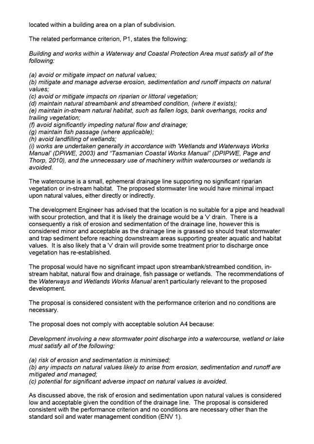
All stormwater from the proposed development (including but not limited to: roofed areas, ag drains, retaining wall ag drains and impervious surfaces such as driveways and paved areas) must be drained to the Council’s water course via the private easement over 60 Hall Street prior to first occupation or commencement of use (whichever occurs first).
Reason for condition
To ensure that stormwater from the site will be discharged to a suitable Council approved outlet.
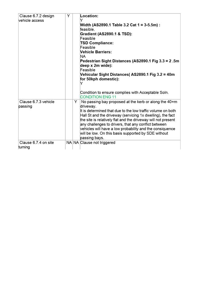
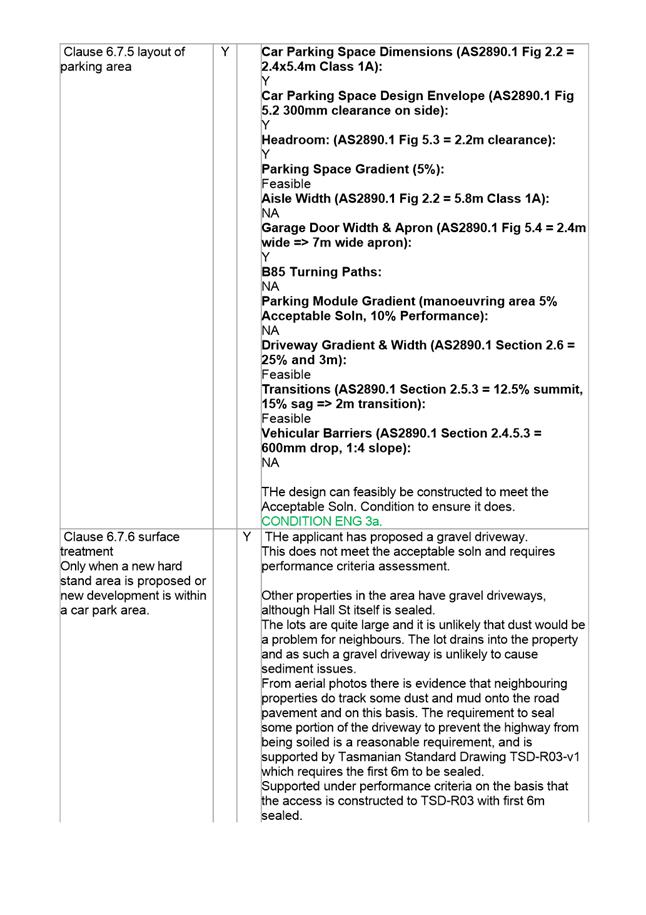
ENG 3a
The access, driveway and parking module (parking spaces, aisles and manoeuvring area) must be designed and constructed in accordance with Australian Standard AS/NZS2890.1:2004 prior to first occupation.
Reason for condition
To ensure the safety of users of the access and parking module, and compliance with the relevant Australian Standard.
ENG 11
Prior to the first occupation, the proposed crossover to the Hall Street highway reservation must be designed and constructed in general accordance with:
1. LGAT Standard Drawing Rural – TSDR04v1 – Rural Roads Typical Driveway Profile and TSD R03v1 Rural Roads Typical Property Access. 2. Or a Council City Infrastructure Division approved alternate design.
Advice:
· Local Government Association (LGAT) Tasmanian Standard Drawings (TSD) can be viewed electronically via the LGAT Website. · Please note that the first six (6) metres of the access will be required to be sealed in accordance with TSDR03v1 · You will require a Permit to Open Up and Temporarily Occupy a Highway (for work within the highway reservation). Click here for more information.
Reason for condition
In the interests of vehicle user safety and the amenity of the development.
ENG 1
Any damage to Council infrastructure resulting from the implementation of this permit, must, at the discretion of the Council:
1. Be met by the owner by way of reimbursement (cost of repair and reinstatement to be paid by the owner to the Council); or 2. Be repaired and reinstated by the owner to the satisfaction of the Council.
A photographic record of the Council's infrastructure adjacent to the subject site must be provided to the Council prior to any commencement of works.
A photographic record of the Council’s infrastructure (e.g. existing property service connection points, roads, buildings, stormwater, footpaths, driveway crossovers and nature strips, including if any, preexisting damage) will be relied upon to establish the extent of damage caused to the Council’s infrastructure during construction. In the event that the owner/developer fails to provide to the Council a photographic record of the Council’s infrastructure, then any damage to the Council's infrastructure found on completion of works will be deemed to be the responsibility of the owner.
Reason for condition
To ensure that any of the Council's infrastructure and/or siterelated service connections affected by the proposal will be altered and/or reinstated at the owner’s full cost.
ENV 1
Sediment and erosion control measures sufficient to prevent sediment from leaving the site must be installed prior to any disturbance of the site, and maintained until all areas of disturbance have been stabilized or revegetated.
Advice:
For further guidance in preparing a Soil and Water Management Plan – in accordance with Fact sheet 3 Derwent Estuary Program click here.
Reason for condition
To avoid the sedimentation of roads, drains, natural watercourses, Council land that could be caused by erosion and runoff from the development, and to comply with relevant State legislation.
PLN 17
The palette of exterior colours and materials must be coloured using colours with a light reflectance value not greater than 40 percent.
Prior to the issue of any approval under the Building Act 2016, revised plans must be submitted and approved showing exterior colours and materials in accordance with the above requirement.
All work required by this condition must be undertaken in accordance with the approved plans.
Reason for condition
To ensure that the location and appearance of buildings and works minimises adverse impact on the landscape.
ADVICE
The following advice is provided to you to assist in the implementation of the planning permit that has been issued subject to the conditions above. The advice is not exhaustive and you must inform yourself of any other legislation, bylaws, regulations, codes or standards that will apply to your development under which you may need to obtain an approval. Visit the Council's website for further information.
Prior to any commencement of work on the site or commencement of use the following additional permits/approval may be required from the Hobart City Council.
CONDITION ENDORSEMENT PLANNING
If a condition endorsement is required by a planning condition above, you will need to submit the relevant documentation to satisfy the condition via the Condition Endorsement Submission on Council's online services eplanning
Where building approval is also required, it is recommended that documentation for condition endorsement be submitted well before submitting documentation for building approval. Failure to address condition endorsement requirements prior to submitting for building approval may result in unexpected delays.
Once approved, the Council will respond to you via email that the condition has been endorsed (satisfied). Detailed instructions can be found here.
BUILDING PERMIT
You may need building approval in accordance with the Building Act 2016. Click here for more information.
This is a Discretionary Planning Permit issued in accordance with section 57 of the Land Use Planning and Approvals Act 1993.
PLUMBING PERMIT
An application and approval for a Plumbing Permit is required prior to the commencement of building works of the proposed dwelling. This application must be accompanied with the site & soil evaluation report titled GeoEnvironmental Assessment 58 Hall Street Ridgeway November 2017.
A Plumbing Permit application form and further information regarding Plumbing Permits can be located on Council’s website.
OCCUPATION OF THE PUBLIC HIGHWAY
As you are constructing a new driveway access on the Highway Reservation, you will require a Permit to Open Up and Temporarily Occupy a Highway (for work in the road reserve). Click here for more information.
STORM WATER
Please note that in addition to a building and/or plumbing permit, development must be in accordance with the Hobart City Council’s Hydraulic Services By law. Click here for more information.
ACCESS
Designed in accordance with LGAT IPWEA – Tasmanian standard drawings. Click here for more information.
CROSS OVER CONSTRUCTION
The construction of the crossover can be undertaken by the Council or by a private contractor, subject to Council approval of the design. Click here for more information.
WEED CONTROL
Effective measures are detailed in the Tasmanian Washdown Guidelines for Weed and Disease Control: Machinery, Vehicles and Equipment (Edition 1, 2004). The guidelines can be obtained from the Department of Primary Industries, Parks, Water and Environment website.
FEES AND CHARGES
Click here for information on the Council's fees and charges.
DIAL BEFORE YOU DIG
Click here for dial before you dig information. .
|
Attachment a: PLN-18-779
- 58-60 HALL STREET RIDGEWAY TAS 7054 - Planning Committee or Delegated Report ⇩ ![]()
Attachment
b: PLN-18-779
- 58-60 HALL STREET RIDGEWAY TAS 7054 - CPC Agenda Documents ⇩ ![]()
Attachment
c: PLN-18-779
- 58-60 HALL STREET RIDGEWAY TAS 7054 - Referral Officer Reports (Development
Engineering and Environmental Development Planning) ⇩ ![]()
Attachment
d: PLN-18-779
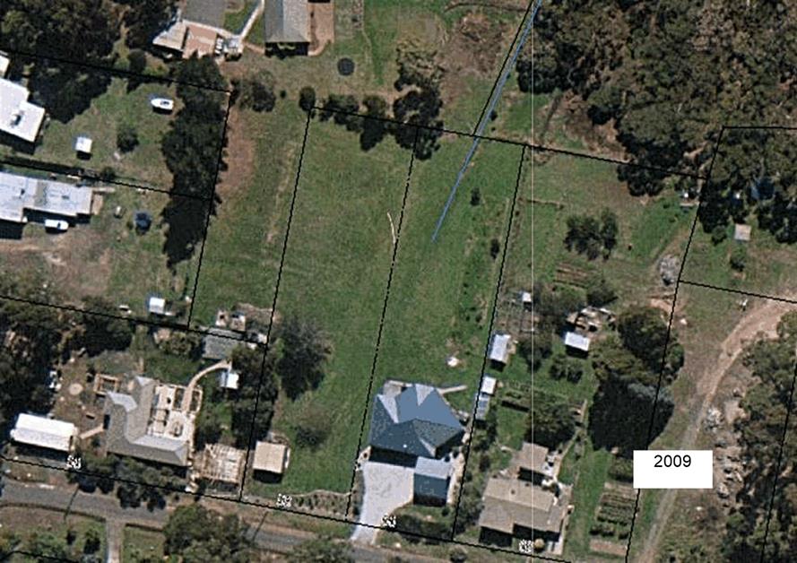
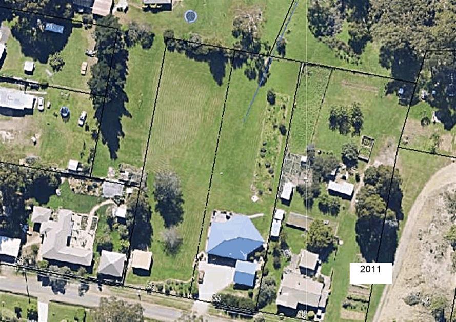
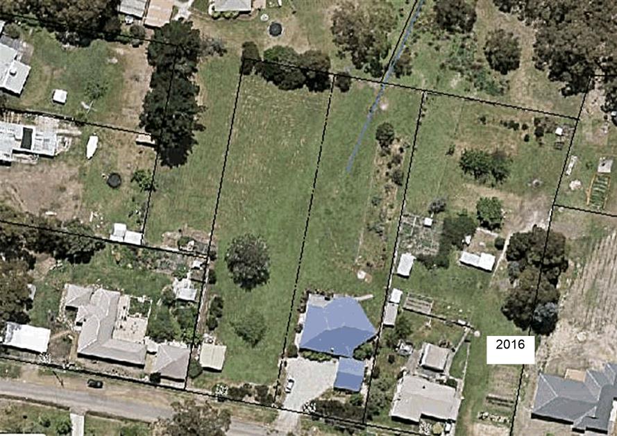
- 58-60 HALL STREET RIDGEWAY TAS 7054 - Historic Aerial Photos ⇩ ![]()
|
Item No. 7.2.3 |
Agenda (Open Portion) City Planning Committee Meeting - 25/2/2019 |
Page 212 ATTACHMENT a |
|
Agenda (Open Portion) City Planning Committee Meeting - 25/2/2019 |
Page 241 ATTACHMENT b |
|
Item No. 7.2.3 |
Agenda (Open Portion) City Planning Committee Meeting - 25/2/2019 |
Page 242 ATTACHMENT b |
|
Item No. 7.2.3 |
Agenda (Open Portion) City Planning Committee Meeting - 25/2/2019 |
Page 248 ATTACHMENT b |
|
Item No. 7.2.3 |
Agenda (Open Portion) City Planning Committee Meeting - 25/2/2019 |
Page 259 ATTACHMENT b |
|
Item No. 7.2.3 |
Agenda (Open Portion) City Planning Committee Meeting - 25/2/2019 |
Page 263 ATTACHMENT b |
|
Item No. 7.2.3 |
Agenda (Open Portion) City Planning Committee Meeting - 25/2/2019 |
Page 275 ATTACHMENT c |

|
Agenda (Open Portion) City Planning Committee Meeting - 25/2/2019 |
Page 283 ATTACHMENT d |
|
Agenda (Open Portion) City Planning Committee Meeting |
Page 288 |
|
|
|
25/2/2019 |
|
8. Reports
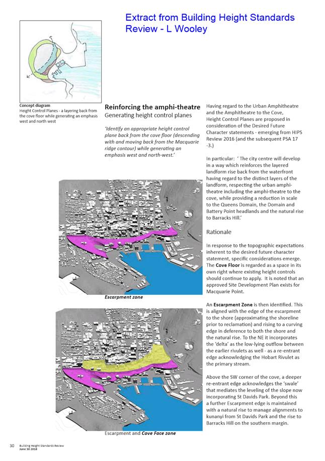
8.1 Central Hobart Building Height Standards Review Project - Environmental, Economic and Social Impact Assessment - Project Brief
Report of the Manager Planning Policy and Heritage and the Director City Growth of 20 February 2019 and attachment.
Delegation: Council
|
Item No. 8.1 |
Agenda (Open Portion) City Planning Committee Meeting |
Page 289 |
|
|
25/2/2019 |
|
REPORT TITLE: Central Hobart Building Height Standards Review Project - Environmental, Economic and Social Impact Assessment - Project brief
REPORT PROVIDED BY: Manager Planning Policy and Heritage
Director City Growth
1.1. This report is in response to the Council resolution of 17 December 2018:
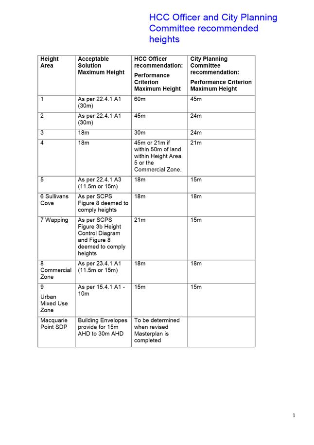
That a report be commissioned that considers the social, environmental, economic, affordable housing, Airbnb and holiday accommodation impact assessment which compares the impacts of the four proposed height restrictions as detailed in:
1. The current planning scheme regulations.
2. The original Leigh Woolley report.
3. The amendments recommended to the Leigh Woolley report as contained in the officer report, marked as attachment B to item 8.2 of the City Planning Agenda of 10 December 2018.
4. The City Planning Committee recommendations of 10 December 2018 to Council.
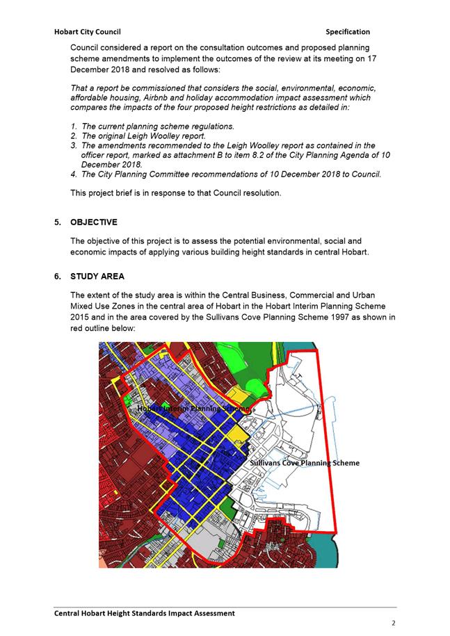
1.2. The report seeks Councils endorsement of a project brief (Attachment A) to engage a consultant to assess the potential environmental, social and economic impacts of applying various building height standards in central Hobart.
1.3. The proposal benefits the community by helping to ensure that the height of development in the central area of Hobart and Sullivans Cove makes a positive contribution to the streetscape and townscape values, provides for appropriate economic development and meets community expectations.
2. Report Summary
2.1. This report seeks Councils endorsement of a project brief (Attachment A) to engage a consultant to assess the potential environmental, social and economic impacts of applying various building height standards in central Hobart.
2.2. The proposed scope of the project is outlined in section 7 of the Project Brief. It requires a number of questions to be addressed in relation to environmental, social and economic impacts and considering those impacts poses the question; What is the optimal built form in central Hobart that would meet Hobart’s future housing and development needs and meet the community aspirations for the future of Hobart as articulated in: Hobart: A community vision for our island capital?
2.3. On completion of the project it is proposed that the consultants provide the City Planning Committee with a presentation of their findings, including conclusions and recommendations.
2.4. Project completion is expected by 30 July 2019.
|
That the project brief for an assessment of the potential environmental, social and economic impacts of applying various building height standards in central Hobart, provided in Attachment A, be endorsed and three (3) suitably qualified consultants be invited to submit a quotation to undertake the project.
|
4. Background
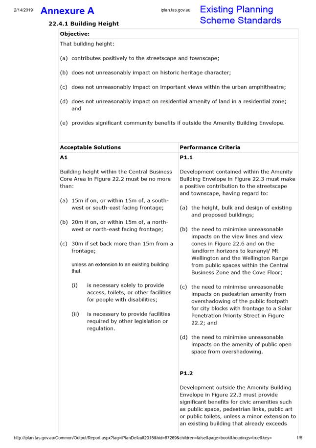
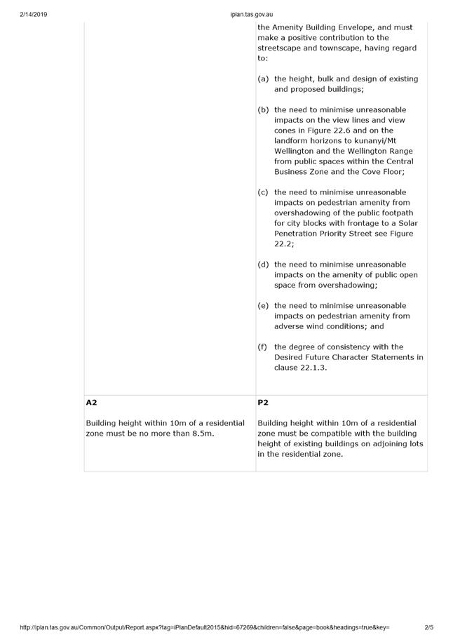
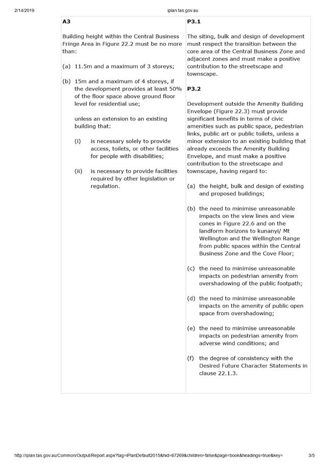
4.1. The current development standards for buildings in the Central Business Zone in the HIPS2015 were formulated after a detailed review and analysis of land use and development patterns in the central city area. The development standards address building height, setbacks, design, passive surveillance, outdoor storage, pedestrian links, heritage, streetscape and sense of scale, wind effects and solar penetration.
4.2. At its meeting on 3 July 2017, the Council endorsed the recommendations of the Central Business Zone Height Standards – Performance Criteria Review report (Woolley 2016) and initiated the PSA-17-3 Amendments to the HIPS2015 to implement the recommendations of that report in relation to streetscape and townscape values. A modified version of those amendments were approved by the Tasmanian Planning Commission on 3 August 2018.
4.3. At its meeting on 3 July
2017, the Council also resolved that:
A further report to Council be prepared addressing the additional
analysis required in relation to a number of issues including the preparation
of design guidelines, modelling of buildings in certain locations, development of
spatial principles to inform appreciation of the ‘urban
amphitheatre’, designation of additional view protection planes, height
control planes and specification of maximum height limits.
4.4. At its meeting on 9 October 2017, the Council endorsed the project brief for that work and subsequently Leigh Woolley - Architect and Urban Design Consultant was commissioned to undertake the project.
4.5. At its meeting on 3 September 2018, the Council endorsed the release of the Building Height Standards Review (L Woolley, 30 June 2018) report and the suggested planning scheme amendments to implement its recommendations, for public comment for a 6 week period, prior to consideration of formally endorsing the report and initiating any planning scheme amendments in response.
4.6. Council considered a report on the consultation outcomes and proposed planning scheme amendments to implement the outcomes of the review at its meeting on 17 December 2018 and resolved that a report be commissioned that considers the social, environmental, economic, affordable housing and visitor accommodation impacts of various building height standards.
5. Proposal and Implementation
5.1. It is proposed that the project brief in Attachment A be endorsed and three (3) suitably qualified consultants be invited to submit a quotation to undertake the project.
5.2. The primary objective of the project is to assess the potential environmental, social and economic impacts of applying various building height standards in central Hobart.
5.3. The proposed scope of the project is outlined in section 7 of the Project Brief. It requires the following questions to be addressed:
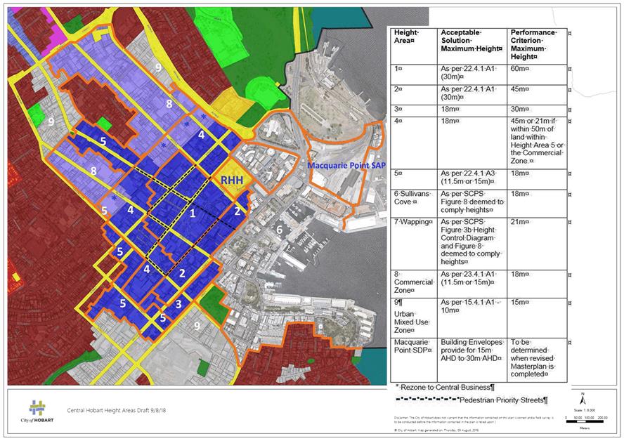
5.3.1. What are the comparative impacts of the 4 building height standard options (attached), concerning the following?
5.3.1.1. Social matters that affect people or communities such as; access to employment, access to housing generally and affordable housing, heritage values, urban form and residential amenity.
5.3.1.2. Environmental matters arising from the form and density of development in central Hobart in relation to the optimal built form from the perspective of energy, transport and walkability.
5.3.1.3. Economic matters in relation to:
(a) changes in land values on sites likely to be impacted by height limits;
(b) how much of the central city would be impacted by height limits at 45m, 60m and 75m taking into account existing constraints?;
(c) the economic viability of development considering potential economic yield;
(d) the cost of construction in relation to medium and high density;
(e) achievement of the Activity Centre Regional Policies in the Southern Tasmania Regional Land Use Strategy;
(f) the benefits of maintaining the existing townscape and heritage character of central Hobart;
(g) the benefits of enhancing townscape and public amenity through new development;
(h) the likely use of higher buildings; hotels vs residential vs other;
(i) costs for surrounding property and neighbourhood amenity due to impacts from traffic congestion, overshadowing, solar access, loss of residential character and amenity and visual bulk; and
(j) a review of existing studies comparing the overall cost of housing, service provision and transport costs on the city fringe as compared to cost of housing, services and transport costs within or close to the CBD.
5.3.1.4. Visitor accommodation – implications for the future supply of visitor accommodation.
5.3.2. Considering the above, what is the optimal built form in central Hobart that would meet Hobart’s future housing and development needs and meet the community aspirations for the future of Hobart as articulated in: Hobart: A community vision for our island capital?
5.3.3. Do underutilised sites in central Hobart have the potential to accommodate Hobart’s future housing and development needs within the current height standards?
5.4. On completion of the project it is proposed that the consultants provide the City Planning Committee with a presentation of their findings, including conclusions and recommendations.
5.5. Project completion is expected by 30 July 2019.
6. Strategic Planning and Policy Considerations
6.1. The project will assist in the achievement of the strategic objectives of the Capital City Strategic Plan 2015-2025 particularly in relation to Goal 2 Urban Management - 2.3 "City and regional planning ensures quality design, meets community needs...."
6.2. The project is also relevant to the community aspirations for the future of Hobart as articulated in: Hobart: A community vision for our island capital, particularly in relation to the statements in:
6.2.1. Pillar 1. Sense of Place: We are a city of unique beauty, environment, heritage and people, built on a shared sense of ownership, pride and wonder.
6.2.2. Pillar 4. City Economies: We are a city whose economies connect people, businesses, education and government to create a high-quality lifestyle in a thriving and diverse community. Our city is our workshop. We collaborate, embracing ideas, inventiveness and initiative.
6.2.3. Pillar 5. Movement and Connectivity: We are a city where everyone has effective, safe, healthy and environmentally-friendly ways to move and connect, with people, information and goods, and to and through spaces and the natural environment. We are able to maintain a pace of life that allows us to fulfil our needs, such as work, study, business, socialising, recreation, accessing services, shopping, entertainment and spending time with loved ones.
6.2.4. Pillar 6. Natural Environment: We are a city whose people see ourselves as part of a beautiful and unique natural environment, from the mountain to the river, which embrace us and shape our identity. We are proud custodians and advocates, ensuring resources are appreciated rather than wasted, supporting biodiverse ecosystems in honour of past, current and future generations.
6.2.5. Pillar 7. Built Environment: We are a city that maintains our unique built and ecological character, where we all have a safe, secure and healthy place to live. We are a city where people and communities can access world-class services and infrastructure and provide for their social, cultural and economic wellbeing. We embrace change but not at the expense of our Hobart identity and character.
7. Financial Implications
7.1. Funding Source and Impact on Current Year Operating Result
7.1.1. The proposed budget for the project is $50,000. This amount can be partially funded from the 2018/2019 budget allocation for the Planning Policy function. A further budget allocation will need to be made in the 2019/2020 financial year to cover the shortfall.
7.2. Impact on Future Years’ Financial Result
7.2.1. As above.
7.3. Asset Related Implications
7.3.1. None.
8. Legal, Risk and Legislative Considerations
8.1. None at this stage of the process.
9. Community and Stakeholder Engagement
9.1. Given the significant community interest in relation to building height standards in central Hobart it is suggested that the report resulting from this project be made available for public comment prior to any Council decision to proceed with planning scheme amendments.
10. Delegation
10.1. This matter is delegated to the Council.
As signatory to this report, I certify that, pursuant to Section 55(1) of the Local Government Act 1993, I hold no interest, as referred to in Section 49 of the Local Government Act 1993, in matters contained in this report.
|
James McIlhenny Manager Planning Policy and Heritage |
Neil Noye Director City Growth |
Date: 20 February 2019
File Reference: F19/17273; 17/167
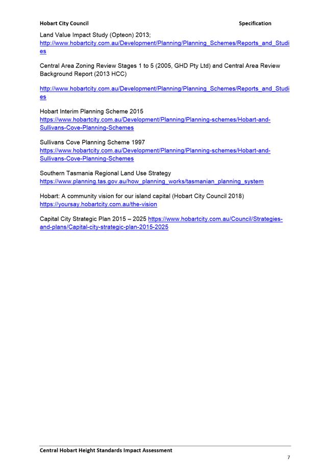
Attachment a: Central
Hobart Height Impact Assessment Project Brief ⇩ ![]()
|
Item No. 8.1 |
Agenda (Open Portion) City Planning Committee Meeting - 25/2/2019 |
Page 295 ATTACHMENT a |
|
Item No. 8.1 |
Agenda (Open Portion) City Planning Committee Meeting - 25/2/2019 |
Page 318 ATTACHMENT a |
|
Item No. 8.1 |
Agenda (Open Portion) City Planning Committee Meeting - 25/2/2019 |
Page 322 ATTACHMENT a |
|
Item No. 8.1 |
Agenda (Open Portion) City Planning Committee Meeting - 25/2/2019 |
Page 323 ATTACHMENT a |
|
Item No. 8.1 |
Agenda (Open Portion) City Planning Committee Meeting - 25/2/2019 |
Page 324 ATTACHMENT a |
|
Agenda (Open Portion) City Planning Committee Meeting |
Page 347 |
|
|
|
25/2/2019 |
|
8.2 Review of Planning Directive No. 1 (Bushfire-Prone Areas Code) and the Building Regulations 2016 for Bushfire-Prone Areas
Report of the Environment Development Planner and the Manager Planning Policy and Heritage of 20 February 2019.
Delegation: Council
|
Item No. 8.2 |
Agenda (Open Portion) City Planning Committee Meeting |
Page 348 |
|
|
25/2/2019 |
|
REPORT TITLE: Review of Planning Directive No. 1 (Bushfire-Prone Areas Code) and the Building Regulations 2016 for Bushfire-Prone Areas
REPORT PROVIDED BY: Environment Development Planner
Manager Planning Policy and Heritage
1. Report Purpose and Community Benefit
1.1. This report concerns the operation of the Bushfire-Prone Areas Code and the provisions of the Building Regulations 2016 applying to bushfire-prone areas.
1.2. Effective operation of the Bushfire Prone Areas Code and the Building Regulations 2016 benefits the community by providing for a safer environment.
2. Report Summary
2.1. This report provides a review of the operation of the Bushfire-Prone Areas Code and the bushfire-prone area regulations under the Buildings Regulations 2016 since February 2017.
2.2. Some bushfire reports and bushfire hazard management plans submitted as part of planning applications to satisfy the Bushfire-Prone Areas Code have needed amendments and corrections, however these have been dealt with relatively easily as part of the planning process through additional information requests and/or permit conditions.
2.3. Where bushfire reports and bushfire hazard management plans have been provided to demonstrate vegetation clearing requirements (to meet the building regulations) as part of the planning process, and the accuracy of the assessment has been questionable, applicants have been advised to reconsider the conclusions and/or recommendations and this has generally been done with minimal resistance and satisfactory outcomes achieved.
2.4. To assess building applications where bushfire requirements were not considered as part of the planning approvals process, forty building applications in bushfire-prone areas from 2017 and 2018 were audited, and in the opinion of the Environmental Development Planner, approximately 20% of the applications examined appeared to be non-compliant, either by not addressing the bushfire-prone area regulations at all, or by relying upon incorrect bushfire attack level (BAL) assessments.
2.5. The review has made clear that the major issue is the compliance of building applications with the building regulations relating to bushfire-prone areas (including the accuracy and legitimacy of bushfire assessments prepared by bushfire hazard practitioners), where bushfire assessments are not considered as part of the planning approvals process.
|
That: 1. Council officers continue to monitor compliance with the bushfire-prone area regulations of the Building Regulations 2016 and the vegetation clearing requirements of the Hobart Interim Planning Scheme 2015; 2. Regular audits of building application compliance continue, but with a focus on developments that were not subject to the planning approvals process; 3. Detected instances of significant errors or non-compliance be referred to the Tasmania Fire Service (including those detected as part of the latest audit); and 4. The Tasmania Fire Service be provided with a copy of this report for their information. |
4. Background
4.1. Interim Planning Directive No. 1 (IPD1), which took effect on 23 February 2016, introduced a new Bushfire-Prone Areas Code (Bushfire Code) into the Hobart Interim Planning Scheme 2015.
4.2. The key change to the Bushfire Code was the exclusion of habitable buildings from the code’s application. The IPD1 Bushfire Code only applied to planning applications for subdivision, vulnerable uses and hazard uses. Standards for residential habitable buildings in bushfire-prone areas, similar to those of the former Bushfire Code, were introduced at the same time to the Building Regulations 2014.
4.3. The Director City Growth made a representation to the Tasmanian Planning Commission in May 2016 indicating that the changes may have unintended consequences with regard to vegetation clearing and management. In particular, concern was raised that applicants may not be aware of the exact requirements for vegetation clearing for bushfire hazard management areas under the building regulations at the time of making a planning application, potentially leading to failure to apply for any necessary planning approval for vegetation clearing.
4.4. In light of these concerns, in May 2016 Council requested that officers provide a report to the City Planning Committee regarding the operation of the IPD1 Bushfire Code.
4.5. Officers carried out a review of the operation of the new Bushfire Code and the Building Regulations 2014. This included an audit of building applications in bushfire-prone areas to determine compliance with the amended building regulations and also with the vegetation clearing requirements of the Biodiversity Code of the Hobart Interim Planning Scheme 2015.
4.6 The review report was considered by the City Planning Committee on 27 February 2017. The report indicated that:
4.6.1 Implementation of the new Bushfire Code and amended regulations had generally been easier for Council than the previous system because the new Bushfire Code had less extensive application, the new Code included improvements in the clarity of requirements and because assessment and implementation of the new requirements under the building regulations was largely the responsibility of private building surveyors or accredited bushfire hazard practitioners.
4.6.2 To help minimise the potential for unlawful vegetation clearing or for proponents to have to obtain additional planning approval, applicants were being proactively advised (if located in areas that may trigger the Biodiversity Code) to consider and determine vegetation clearing requirements for bushfire risk mitigation at the time of making a planning application.
4.6.3 The level of construction of a building under Australian Standard AS3959: Construction of Buildings in Bushfire Prone Areas also needed to be established for some dwelling applications in order to assess compliance with relevant standards under the Biodiversity Code of the planning scheme.
4.6.4 Officers were not aware of any instances where vegetation clearing had definitely occurred without planning approval due to vegetation clearing requirements only becoming apparent to developers at the building approvals stage, or situations where additional planning approval had been sought for vegetation clearing.
4.6.5 The critical issue for the new system, from a bushfire perspective, was how well the requirements of the building regulations were being implemented. To help to determine this, twenty seven building applications in bushfire-prone areas from 2016 were audited to determine whether the regulations had been correctly implemented.
4.6.6 Twenty two of the twenty seven applications examined appeared generally compliant with the regulations.
4.6.7 Overall, given that the system was fairly new, had changed frequently over the previous five years, was complex and sometimes unclear there was found to be a reasonable level of compliance with the regulations. Importantly, the higher risk scenarios involving more significant assets and higher bushfire risk sites generally showed a high level of compliance.
4.6.8 It was expected that the level of compliance with the building regulations would increase over time, and that the risk of unlawful impacts upon native vegetation would decrease, due to increasing familiarity with the new system within the development industry.
4.7 At its meeting the Committee requested that Council officers continue to monitor compliance with the bushfire-prone area building regulations and the vegetation clearing requirements of the Hobart Interim Planning Scheme 2015.
4.8 Since that report was drafted there have been further changes to the Bushfire-Prone Areas Code and the Director’s Determination – Requirements for Building in Bushfire-Prone Areas which supports the building regulations:
4.8.1 An amended IPD1 Bushfire Code (IPD1.1) took effect on 23 February 2017 and the Director’s Determination was amended to reflect the Code changes.
4.8.2 The IPD1.1 Bushfire Code was replaced with another Code introduced under Planning Directive 5.1 on 1 September 2017 and the Director’s Determination was amended to reflect the Code changes.
4.9 The IPD1.1 and PD5.1 versions of the Bushfire Code differ from the Code introduced under IPD1 to only a limited extent. The modifications were essentially drafting amendments that clarify and improve the Code’s operation. There were no substantial policy changes. The version of the Bushfire Code introduced under Planning Directive No. 5.1 remains in effect.
4.10 It should also be noted that a bushfire-prone area overlay was inserted into the Bushfire Code of the planning scheme on 30 November 2017. This defines bushfire-prone areas for the purposes of both the Bushfire Code and the building regulations. This ensures there is no ambiguity about whether a particular site is, or is not, bushfire-prone.
5. Proposal and Implementation
5.1. Implementation of the PD5.1 Bushfire Code has remained relatively simple, with significantly fewer planning applications being subject to the Code (almost exclusively subdivisions).
5.2. Some bushfire reports and bushfire hazard management plans (BHMPs) prepared to satisfy the Code for subdivision applications have needed amendments and corrections, however these have been dealt with relatively easily as part of the planning process through additional information requests and/or permit conditions.
5.3. There is some risk that requests for additional information or permit conditions requiring amendments or corrections could be successfully challenged given that under section 51(2)(d)(i) of the Land Use Planning and Approvals Act 1993 planning authorities ‘must accept’ any relevant bushfire hazard management plan that has been certified as acceptable by an accredited person. To date, such requests or conditions have not been challenged.
5.4. The practice of advising applicants of planning applications subject to the Biodiversity Code (or likely to be subject to the Biodiversity Code) to consider and determine vegetation clearing requirements of the building regulations for bushfire-prone areas has continued and remains important to help avoid the risk of vegetation clearing requirements not being considered as part of the planning assessment process. There has been little resistance to providing this information and often copies of certified BHMPs are submitted.
5.5. In a small number of cases no specific information about bushfire hazard management area (HMA) requirements has been provided. In these cases advice has been included on planning permits granted advising that any further vegetation clearing to meet the requirements of the building regulations will require further planning approval.
5.6. Where bushfire reports and BHMPs have been provided to demonstrate vegetation clearing requirements and the accuracy of the assessment has been questionable, applicants have been advised to reconsider the conclusions and/or recommendations and this has generally been done with minimal resistance and satisfactory outcomes achieved.
5.7. There have also been several instances of building permit applications being referred by staff to the Environmental Development Planner for advice about bushfire requirements and BHMPs. In some of those cases major errors with bushfire assessments have been detected and in another case the BHMP required modification of native vegetation for which no planning approval had been received.
5.8. The Tasmania Fire Service (TFS) have been referred bushfire assessments where significant errors have been detected by officers or where it appears that bushfire practitioners have been operating outside their scope of work accreditation. The TFS Chief Officer has the power to revoke accreditations or require professional development where practitioner work is deemed to be sub-standard.
5.9. For a more thorough assessment of the adequacy of building permit applications in meeting the requirements of the building regulations and the competency of the bushfire assessments included in those applications, and also to determine whether building permit BHMPs were proposing vegetation clearing that required, but had not received, planning approval, forty building applications in bushfire-prone areas from 2017 and 2018 were audited.
5.10. The building applications were for dwellings, dwelling extensions and studios. Many of these developments also required planning permits, so bushfire issues for those sites may have been resolved prior to lodgement of building applications.
5.11. While it is difficult to be certain without undertaking full, parallel assessments including site inspections, it is the opinion of the Environmental Development Planner that of the forty building applications audited:
5.11.1. Twenty five (62.5%) appeared to be compliant and correct, or at least arguably correct;
5.11.2. Five (12.5%) appeared to be correct but were deficient in terms of the documentation included (e.g. certification certificates);
5.11.3. Five (12.5%) appeared to have incorrect bushfire attack level assessments and/or did not meet the requirements of the building regulations and/or Director’s Determination.
5.11.4. Three (7.5%) did not address the regulations for bushfire-prone areas despite the regulations appearing to be applicable;
5.11.5. One (2.5%) had an invalid certification as it was outside the practitioner’s scope-of-work accreditation; and
5.11.6. One (2.5%) suggested vegetation clearing was required that had not received, but required, planning approval.
5.12. The perceived errors in bushfire assessments detected over the last few years were most commonly related to:
5.12.1. Underestimating the slope of the land supporting bushfire-prone vegetation;
5.12.2. Classifying vegetation as ‘woodland’ rather than ‘forest’;
5.12.3. Making assumptions about the management of adjoining land without evidence/justification or not in accordance with TFS advisory notes; and
5.12.4. Not considering/recognising pre-existing BHMPs for development sites or adjoining land.
5.13. It is concerning that approximately 20% of the applications examined appeared to be non-compliant, either by not addressing the bushfire-prone area regulations at all, or by relying upon incorrect bushfire attack level (BAL) assessments. This number would have been higher if some of the issues had not been detected and addressed as part of the planning approvals process.
5.14. At the time of the last report, it was expected that the degree of compliance with would increase over time as familiarity with the new system within the design/development industry increased. However, this was not evident when comparing the results of the former and current audits, where levels of compliance were similar.
5.15. The review has made clear that the major issue is not the risk of unlawful vegetation clearing or the need for further approvals, but rather the accuracy and legitimacy of bushfire assessments and the compliance of building applications with the building regulations, where bushfire assessments are not considered as part of the planning approvals process.
5.16. In order to facilitate increased compliance over time, it is recommended that:
5.16.1. Regular audits of building application compliance continue, but with a focus on developments that were not subject to the planning approvals process; and
5.16.2. Detected instances of significant errors or non-compliance are referred to the TFS (including those detected as part of this audit).
5.18 It is also recommended that TFS be provided with a copy of this report for their information.
6. Strategic Planning and Policy Considerations
6.1. The new Bushfire Code and changes to the building regulations have not had a significant effect upon the achievement of the strategic objectives of the Capital City Strategic Plan 2015-2025. However, the lack of Council review of building application compliance with bushfire requirements under the new system may make it more difficult to achieve strategic objective 4.3 ‘Building community resilience, public health and safety’.
7. Financial Implications
7.1. Funding Source and Impact on Current Year Operating Result
7.1.1. The changes to the bushfire regulation system has had no impact upon the current year operating result, and has reduced resource demand in terms of officer assessment time.
7.2. Impact on Future Years’ Financial Result
7.2.1. None.
7.3. Asset Related Implications
7.3.1. None.
8. Legal, Risk and Legislative Considerations
8.1. There is likely to have been a small reduction in Council’s exposure to liability with regard to the risk of incorrect assessment of planning applications under the Bushfire Code, given the reduced applicability of the Bushfire Code, and because the legal responsibility for determining compliance with building regulations largely rests with the building surveyor or accredited bushfire hazard practitioner.
8.2. The more-significant liability risk lies in relation to the ongoing enforcement of bushfire hazard management plans that are required to be complied with under planning permits, building permits and Part 5 Agreements.
9. Environmental Considerations
9.1. Based on officer experience and the audits conducted, the introduction of the IPD1/PD5 bushfire codes and the amended Building Regulations 2014 do not appear to have resulted in any increase in the lawful, or unlawful, clearing of native vegetation.
10. Social and Customer Considerations
10.1. There has been minimal negative feedback from planning permit applicants relating to requests for details of proposed vegetation clearing or bushfire-resistant construction.
10.2. There have been no situations where applicants have had to seek further planning approval due to being unaware of vegetation clearing requirements to meet the building regulations.
10.3. It is still considered essential for Council planners to pro-actively advise applicants to consider bushfire requirements when preparing planning applications.
11. Community and Stakeholder Engagement
11.1. Information is available on the Council’s website about the need to consider requirements for vegetation clearing to meet the Building Regulations 2016 at the planning application stage.
12. Delegation
12.1. This is a matter for the Council to determine.
As signatory to this report, I certify that, pursuant to Section 55(1) of the Local Government Act 1993, I hold no interest, as referred to in Section 49 of the Local Government Act 1993, in matters contained in this report.
|
Rowan Moore Environment Development Planner |
James McIlhenny Manager Planning Policy and Heritage |
Date: 20 February 2019
File Reference: F19/17550; 15/97
|
Item No. 8.3 |
Agenda (Open Portion) City Planning Committee Meeting |
Page 357 |
|
|
25/2/2019 |
|
8.3 City Planning - Advertising List
Memorandum of the Director City Growth of 20 February 2019 and attachment.
Delegation: Committee
|
Item No. 8.3 |
Agenda (Open Portion) City Planning Committee Meeting |
Page 358 |
|
|
25/2/2019 |
|

Memorandum: City Planning Committee
City Planning - Advertising List
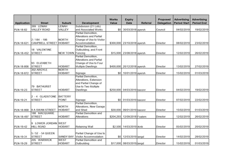
Attached is the advertising list for the period 4 February 2019 – 15 February 2019.
|
That the information contained in the memorandum titled ‘City Planning – Advertising List’ of 20 February 2019 be received and noted.
|
As signatory to this report, I certify that, pursuant to Section 55(1) of the Local Government Act 1993, I hold no interest, as referred to in Section 49 of the Local Government Act 1993, in matters contained in this report.
|
Neil Noye Director City Growth |
|
Date: 20 February 2019
File Reference: F19/18390
Attachment a: City
Planning - Advertising List ⇩ ![]()
|
Item No. 8.3 |
Agenda (Open Portion) City Planning Committee Meeting - 25/2/2019 |
Page 359 ATTACHMENT a |
|
Agenda (Open Portion) City Planning Committee Meeting |
Page 363 |
|
|
|
25/2/2019 |
|
8.4 Delegated Decisions Report (Planning)
Memorandum of the Director City Growth of 20 February 2019 and attachment.
Delegation: Committee
|
Item No. 8.4 |
Agenda (Open Portion) City Planning Committee Meeting |
Page 364 |
|
|
25/2/2019 |
|

Memorandum: City Planning Committee
Delegated Decisions Report (Planning)
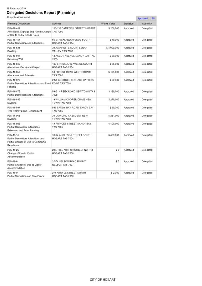
Attached is the delegated planning decisions report for the period 6 February 2019 until 18 February 2019.
|
That the information contained in the memorandum titled ‘Delegated Decisions Report (Planning)’ of 20 February 2019 be received and noted.
|
As signatory to this report, I certify that, pursuant to Section 55(1) of the Local Government Act 1993, I hold no interest, as referred to in Section 49 of the Local Government Act 1993, in matters contained in this report.
|
Neil Noye Director City Growth |
|
Date: 20 February 2019
File Reference: F19/18972
Attachment a: Delegated
Decisions Report (Planning) ⇩ ![]()
|
Item No. 8.4 |
Agenda (Open Portion) City Planning Committee Meeting - 25/2/2019 |
Page 365 ATTACHMENT a |
|
Agenda (Open Portion) City Planning Committee Meeting |
Page 366 |
|
|
|
25/2/2019 |
|
Regulation 29(3) Local Government
(Meeting Procedures) Regulations 2015.
File Ref: 13-1-10
The General Manager reports:-
“In accordance with the procedures approved in respect to Questions Without Notice, the following responses to questions taken on notice are provided to the Committee for information.
The Committee is reminded that in accordance with Regulation 29(3) of the Local Government (Meeting Procedures) Regulations 2015, the Chairman is not to allow discussion or debate on either the question or the response.”
9.1 Upgrade to the Molle and Collins Street Intersection
File Ref: F18/146198; 13-1-10
Memorandum of the Director City Growth of 20 February 2019.
9.2 Welfare Institutions
File Ref: F19/12583; 13-1-10
Memorandum of the Director City Growth of 20 February 2019.
Delegation: Committee
|
That the information be received and noted.
|
|
Item No. 9.1 |
Agenda (Open Portion) City Planning Committee Meeting |
Page 367 |
|
|
25/2/2019 |
|
Memorandum: Lord Mayor
Deputy Lord Mayor
Elected Members
Response to Question Without Notice
Upgrade to the Molle and Collins Street Intersection
|
Meeting: City Infrastructure Committee
|
Meeting date: 21 November 2018
|
|
Raised by: Lord Mayor Councillor Reynolds |
|
Question:
Could the Director please provide clarity in relation to the timeframe expected as to when works will commence upgrading the Molle and Collins Street intersection exiting the Hobart Rivulet carpark. I understand that it is listed for commencement in 2021, however is this still the latest thinking?
Response:
Planning for the proposed upgrade will be completed this calendar year with works to be undertaken in 2020 calendar year.
As signatory to this report, I certify that, pursuant to Section 55(1) of the Local Government Act 1993, I hold no interest, as referred to in Section 49 of the Local Government Act 1993, in matters contained in this report.
|
Neil Noye Director City Growth |
|
Date: 20 February 2019
File Reference: F18/146198; 13-1-10
|
Item No. 9.2 |
Agenda (Open Portion) City Planning Committee Meeting |
Page 368 |
|
|
25/2/2019 |
|
Memorandum: Lord Mayor
Deputy Lord Mayor
Elected Members
Response to Question Without Notice
Welfare Institutions
|
Meeting: City Planning Committee
|
Meeting date: 29 January 2019
|
|
Raised by: Alderman Denison |
|
Question:
Is the Director able to provide a list of welfare institutions approved by the Council over the last 10 years as defined under the previous City of Hobart Planning Scheme 1982?
Response:
There has been 15 applications in the last 10 years involving the change of use or intensification to welfare institution as defined under the former City of Hobart Planning Scheme 1982. The Council will recall that the definition of welfare institution was;
An institution for the care and maintenance of children, the disadvantaged, the aged or the infirm, or a benevolent institution, but does not include a hospital, or a reformative or penal institution.
As signatory to this report, I certify that, pursuant to Section 55(1) of the Local Government Act 1993, I hold no interest, as referred to in Section 49 of the Local Government Act 1993, in matters contained in this report.
|
Neil Noye Director City Growth |
|
Date: 20 February 2019
|
|
Agenda (Open Portion) City Planning Committee Meeting |
Page 369 |
|
|
25/2/2019 |
|
Section 29 of the Local Government (Meeting Procedures) Regulations 2015.
File Ref: 13-1-10
An Elected Member may ask a question without notice of the Chairman, another Elected Member, the General Manager or the General Manager’s representative, in line with the following procedures:
1. The Chairman will refuse to accept a question without notice if it does not relate to the Terms of Reference of the Council committee at which it is asked.
2. In putting a question without notice, an Elected Member must not:
(i) offer an argument or opinion; or
(ii) draw any inferences or make any imputations – except so far as may be necessary to explain the question.
3. The Chairman must not permit any debate of a question without notice or its answer.
4. The Chairman, Elected Member, General Manager or General Manager’s representative who is asked a question may decline to answer the question, if in the opinion of the respondent it is considered inappropriate due to its being unclear, insulting or improper.
5. The Chairman may require a question to be put in writing.
6. Where a question without notice is asked and answered at a meeting, both the question and the response will be recorded in the minutes of that meeting.
7. Where a response is not able to be provided at the meeting, the question will be taken on notice and
(i) the minutes of the meeting at which the question is asked will record the question and the fact that it has been taken on notice.
(ii) a written response will be provided to all Elected Members, at the appropriate time.
(iii) upon the answer to the question being circulated to Elected Members, both the question and the answer will be listed on the agenda for the next available ordinary meeting of the committee at which it was asked, where it will be listed for noting purposes only.
|
|
Agenda (Open Portion) City Planning Committee Meeting |
Page 370 |
|
|
25/2/2019 |
|