City
of hobart
AGENDA
City Infrastructure Committee Meeting
Open Portion
Wednesday, 30 May 2018
at 5:00 pm
Lady Osborne Room, Town Hall
City
of hobart
AGENDA
City Infrastructure Committee Meeting
Open Portion
Wednesday, 30 May 2018
at 5:00 pm
Lady Osborne Room, Town Hall
THE MISSION
Our mission is to ensure good governance of our capital City.
THE VALUES
The Council is:
|
about people |
We value people – our community, our customers and colleagues. |
|
professional |
We take pride in our work. |
|
enterprising |
We look for ways to create value. |
|
responsive |
We’re accessible and focused on service. |
|
inclusive |
We respect diversity in people and ideas. |
|
making a difference |
We recognise that everything we do shapes Hobart’s future. |
|
|
Agenda (Open Portion) City Infrastructure Committee Meeting |
Page 3 |
|
|
30/5/2018 |
|
Business listed on the agenda is to be conducted in the order in which it is set out, unless the committee by simple majority determines otherwise.
APOLOGIES AND LEAVE OF ABSENCE
1. Co-Option of a Committee Member in the event of a vacancy
3. Consideration of Supplementary Items
4. Indications of Pecuniary and Conflicts of Interest
6.2 New Town Retail Precinct - Proposed Streetscape Concept
6.3 Hobart Bicycle Advisory Committee Meeting Notes
7. Motions of which Notice has been Given
8. Committee Action Status Report
8.1 Committee Actions - Status Report
10. Closed Portion Of The Meeting
|
|
Agenda (Open Portion) City Infrastructure Committee Meeting |
Page 4 |
|
|
30/5/2018 |
|
City Infrastructure Committee Meeting (Open Portion) held Wednesday, 30 May 2018 at 5:00 pm in the Lady Osborne Room, Town Hall.
|
COMMITTEE MEMBERS Burnet (Chairman) Lord Mayor Christie Reynolds Harvey Denison
ALDERMEN Deputy Lord Mayor Sexton Zucco Briscoe Ruzicka Cocker Thomas |
Apologies:
Leave of Absence: Nil.
|
|
The minutes of the Open Portion of the City Infrastructure Committee meeting held on Thursday, 26 April 2018 and the Special City Infrastructure Committee meeting held on Monday, 19 March 2018 are submitted for confirming as an accurate record.
|
Ref: Part 2, Regulation 8(6) of the Local Government (Meeting Procedures) Regulations 2015.
|
That the Committee resolve to deal with any supplementary items not appearing on the agenda, as reported by the General Manager.
|
Ref: Part 2, Regulation 8(7) of the Local Government (Meeting Procedures) Regulations 2015.
Aldermen are requested to indicate where they may have any pecuniary or conflict of interest in respect to any matter appearing on the agenda, or any supplementary item to the agenda, which the committee has resolved to deal with.
Regulation 15 of the Local Government (Meeting Procedures) Regulations 2015.
A committee may close a part of a meeting to the public where a matter to be discussed falls within 15(2) of the above regulations.
In the event that the committee transfer an item to the closed portion, the reasons for doing so should be stated.
Are there any items which should be transferred from this agenda to the closed portion of the agenda, or from the closed to the open portion of the agenda?
|
Agenda (Open Portion) City Infrastructure Committee Meeting |
Page 6 |
|
|
|
30/5/2018 |
|
6.1 Land Above McRobies Gully Landfill Site, South Hobart - Approval to Lodge a 'Proposal for a Conservation Covenant'
Report of the Cleansing & Solid Waste Policy Coordinator, the Manager Cleansing and Solid Waste and the Director Parks and City Amentiy of 23 May 2018 and attachment.
Delegation: Council
|
Item No. 6.1 |
Agenda (Open Portion) City Infrastructure Committee Meeting |
Page 7 |
|
|
30/5/2018 |
|
REPORT TITLE: Land Above McRobies Gully Landfill Site, South Hobart - Approval to Lodge a 'Proposal for a Conservation Covenant'
REPORT PROVIDED BY: Cleansing & Solid Waste Policy Coordinator
Manager Cleansing and Solid Waste
Director Parks and City Amenity
1. Report Purpose and Community Benefit
1.1. The purpose of this report is to seek approval for the lodgement of a ‘Proposal for a Conservation Covenant’ over City-owned land above the McRobies Gully Landfill site, South Hobart.
1.2. The report also provides detail of a program to plant blue gum trees in the City to offset the removal of trees from the McRobies Gully Landfill site area, previously approved by the EPA.
2. Report Summary
2.1. The City has a permit to operate the McRobies Gully landfill to a height of 200m, which provides sufficient space to operate the landfill until 2030.
2.2. The permit included a clause related to protection of flora and fauna (clause FF2 of Permit Part B No. 9332), which resulted in the City developing a Vegetation Removal Management Plan. The plan has been approved by the EPA.
2.3. The lodgement of a ‘Proposal for a Conservation Covenant’ and the implementation of a blue gum replanting program finalises the requirements of the Permit issued by the EPA to operate the landfill until 2030.
2.4. These actions will ensure protection of the habitat in the vicinity of McRobies Gully during the life of the landfill and beyond. Securing conservation of this land demonstrates the City’s commitment to protection of the environment.
|
That: 1. Approval be provided for the lodgement of a ‘Proposal for a Conservation Covenant’ in accordance with the Nature Conservation Act 2002, for City-owned land above the McRobies Gully Landfill site, South Hobart. 2. The Blue Gum Offset Planting Program to be undertaken by the City be noted. |
4. Background
4.1. The City developed a Vegetation Removal Management Plan to comply with the requirements of clause FF2 of Permit Part B No. 9332 to operate the McRobies Gully Landfill. The plan has been approved by the EPA, and includes 2 key actions to offset the impact of developments at the site.
· Action 1
Conserving remaining City-owned land above the McRobies
Gully landfill site to ensure long term protection of swift parrot potential
habitat.
· Action 2
Blue gum planting project outside the McRobies Gully
Landfill property.
4.2. The City engaged the services of an ecological consultant to assist with the completion of these actions. A Conservation Covenant (to be lodged in accordance with the Nature Conservation Act 2002) has been drafted and included in this report as Attachment A.
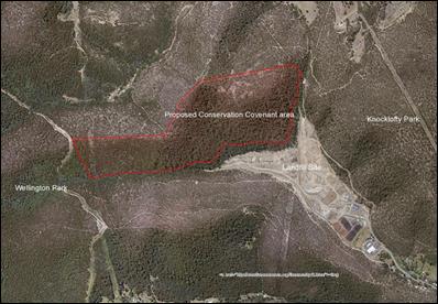
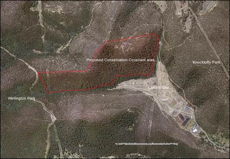
4.3. The Covenant will ensure the area above the McRobies Gully landfill site remains protected from development, with no construction of infrastructure permitted in the area. The proposed area is shown in Figure 1.
Figure 1 – Boundary of proposal area
4.4. The
proposal area is all native forest except for an area of managed vegetation
under high voltage transmission lines.
It incorporates a small area of existing vehicular tracks,
a very small area of informal walking tracks and a City-built and maintained
mountain bike trail.
The proposal area is in very good ecological condition and exhibits a
range of forest vegetation types reflecting changes in geology, aspect, slope
and drainage.
4.5. Recreational activities such as bushwalking, mountain biking, horse riding are all permitted within the proposed conservation area.
4.6. Existing
fences and tracks within the conserved area (walking and bike tracks, fire
trails) will to be maintained.
New walking and vehicular tracks, fuel reduction burns and fire breaks
will be permitted, with approval from the Minister.
4.7. The
development of McRobies Gully Landfill to 200m will result in 32 blue gums
being removed.
An offset planting program has been developed, resulting in 100-150
trees to be planted at other locations within the City.
4.8. City officers have investigated various locations around the City to identify suitable locations to plant blue gums (E.globulus), a known habitat for swift parrots.
4.9. The location selected is in the vicinity of Truganini Track, Porters Hill. The area has in the past been more populated with blue gums, however fire and historic minor clearing (war time) has reduced the number of blue gum trees from what it was 100 years ago.
4.10. Planting blue gums
in this area will help to restore the area to its original vegetation type and
complement and expand a nearby stand of blue gums.
Increasing the amount of blue gums in this wider area will improve the
availability of foraging habitat for Swift Parrots in the long term.
4.11. The planting program will not involve felling of established trees in the area. Planting will involve the establishment of small clearings (2-3 metres) for each blue gum.
5. Proposal and Implementation
5.1. It is proposed that the General Manager be authorised to sign and lodge the ‘Proposal for a Conservation Covenant’ in accordance with the Nature Conservation Act 2002 (Attachment A).
5.2. The blue gum offset planting program will commence with the gathering of seed from the local area. Seeds will be cultivated in the City’s Mornington Nursery. Seedlings in addition to the minimum requirement will be planted initially, to counter natural attrition through factors such as weather and animal browsing.
5.3. A long term monitoring and assessment plan will be developed to manage the offset planting program, to ensure the amount of plants growing in the area always exceeds the minimum requirement (100 plants).
6. Strategic Planning and Policy Considerations
6.1. The development and implementation of the Waste Management Strategy 2015-2030 is identified in the City’s Strategic Plan (3.2.5).
6.2. The proposals contained within this report enable the continued use of McRobies Gully landfill as a strategic asset until 2030.
7. Financial Implications
7.1. Funding Source and Impact on Current Year Operating Result
7.1.1. No Impact.
7.2. Impact on Future Years’ Financial Result
7.2.1. No Impact.
8. Legal, Risk and Legislative Considerations
8.1. The McRobies Gully Waste Management Centre operates under a permit issued by the Tasmanian State Government Environment Protection Agency.
8.2. There are legislated processes associated with this report, such as lodgement of a Proposal for a Conservation Covenant (under the Nature Conservation Act 2002).
9. Environmental Considerations
9.1. The ongoing conservation of the land parcel above McRobies Gully landfill site will ensure the habitat of flora and fauna in perpetuity.
9.2. The blue gum offset planting program will provide increased habitat for swift parrots in the Hobart area in the long term.
9.3. Securing the operation of the McRobies Gully Landfill until 2030 provides time for the City to introduce programs to reduce waste to landfill.
10. Marketing and Media
10.1. There are no marketing or media implications associated with this report.
11. Delegation
11.1. This matter is delegated to the Council.
As signatory to this report, I certify that, pursuant to Section 55(1) of the Local Government Act 1993, I hold no interest, as referred to in Section 49 of the Local Government Act 1993, in matters contained in this report.
|
Jeff Holmes Cleansing & Solid Waste Policy Coordinator |
David Holman Manager Cleansing and Solid Waste |
|
Glenn Doyle Director Parks and City Amenity |
|
Date: 23 May 2018
File Reference: F18/46806; 2016-0192
Attachment a: Proposal
for Conservation Covenant - McRobies Gully ⇩ ![]()
|
Item No. 6.1 |
Agenda (Open Portion) City Infrastructure Committee Meeting - 30/5/2018 |
Page 12 ATTACHMENT a |
PROPOSAL FOR A CONSERVATION COVENANT UNDER THE
NATURE CONSERVATION ACT 2002
|
TABLE OF CONTENTS |
|
Part 1. Background / Property, landowner and land title information |
|
Part 2. Natural values and reserve design |
|
Part 3. Threats and management issues |
|
Part 4. Proposal details for Terms of Covenant and Nature Conservation Plan |
|
Part 5. Decision of Property Assessment Group |
|
SPATIAL DATA CHECKLIST – this data must be provided with proposal* |
Data Source (e.g. consultant/PCAB/regulator) |
|
Proposal boundary |
|
|
Vegetation community mapping |
|
|
Threatened species distributions |
|
|
Weed species distributions |
|
|
Tracks – existing and proposed |
|
|
Fences – existing (note condition) and proposed |
|
|
Dams and watercourses |
|
|
Infrastructure – existing or proposed [buildings, pipes, campsites….] |
|
|
Proposed subdivision boundaries/plans |
|
|
Natural Values Report Attached |
|
|
Photos Attached |
|
*Spatial data = .shp, .dbf, .shx, .prj files as minimum for ArcGIS (Esri) or .tab, .map, .dat, .id as minimum for MapInfo
PART ONE: BACK GROUND
|
Program: |
Offset |
|
Person who has prepared this form: |
Phil Bell, Ecological Consultant, 7 Maria St, Swansea, 7190 |
|
Proposed Agreement Term: |
Perpetual
|
|
Reason for the covenant: |
Part of EPA permit conditions for extension of the landfill area at McRobies Gully Landfill. The specific permit conditions relating to the proposal area are as follows: FF2 - Swift Parrot habitat offset 1. Unless otherwise approved in writing by the Director, a Vegetation Removal Management Plan must be submitted to the Director within 6 months of the issue of these conditions, for approval 2. The Vegetation Removal Management Plan must include, but is not limited to, details of the following: · A program, developed in consultation with the DPIPWE, to achieve the objective of offsetting the impacts of the activity on the Swift Parrot (Lathamus discolor) habitat of Eucalyptus globulus wet forest, which may include the reservation of habitat through a private conservation covenant and/or the installation of Swift Parrot nesting boxes; · A timetable for implementation of key aspects of the Vegetation Removal Management Plan and; · A review and reporting program to regularly advise the Director of the results of the implementation of the Vegetation Removal Management Plan 3. The Activity must be undertaken in accordance with the Vegetation Removal Management Plan, as approved in writing by the Director. A copy of the approved ‘Vegetation Removal Management Plan’ is appended. |
|
Agency/s and/or regulator/s requiring covenant: |
EPA, DPIPWE |
|
Significant natural values which the covenant will protect: |
Threatened vegetation community Eucalyptus tenuiramis forest and woodland on sediments (DTO) and threatened species habitat including a significant area of foraging and nesting (breeding) habitat for the Nationally, Critically Endangered swift parrot Lathamus discolor. |
PROPERTY, LANDOWNER AND LAND TITLE INFORMATION
|
Landowner/s: |
City of Hobart |
|
Property Name: |
HCC Disposal Area |
|
Locality: |
McRobies Gully, South Hobart |
|
Land Title Number: |
|
|
Property Identification Number: |
PID 3273346 |
|
Property Address: |
30 McRobies Rd, South Hobart |
|
Area of Property: |
|
|
Area of Proposal: |
53.19 ha |
|
Bioregion: |
South East (IBRA) Bioregion |
|
1:25 Map Sheet/s: |
Hobart 5225 |
|
Postal Address: (if different to above) |
GPO Box 503 Hobart Tasmania 7000 |
|
Residential Address: |
Town Hall Macquarie St Hobart, 7000 |
|
Contact Person: |
Jeff Holmes Cleansing & Waste Policy Coordinator Parks & City Amenity |
|
Phone Number: |
(03) 6278 0272 |
|
Email Address: |
holmesje@hobartcity.com.au |
|
PTR or FRA on Title: |
No |
|
Mortgagee on Title: |
No |
|
Other Third Party Interests on Title: |
No |
|
Unregistered Dealings on Title: |
No |
|
Date of Title Check: |
No |
PART TWO: NATURAL VALUES AND RESERVE DESIGN
|
Date/s of survey work and by whom: |
Site visits by Phil Bell on 30 July, 9 August and 9 November 2017.
|
|
Has there been any other formal survey work conducted on the property which is not recorded on the Natural Values Atlas? |
No. Mark Wapstra and Kevin Bonham surveyed the proposal area on 18 January 2016 as part of an ecological assessment of the proposed extension to the landfill area (primarily focused on threatened vegetation, and threatened flora and fauna issues). A copy of the ‘Ecological Assessment of Proposed Extension of Landfill Area, McRobies Gully Waste Disposal Area, Tasmania’ by ECOtas is appended. |
|
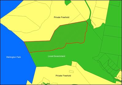
CONTEXT AND RESERVE DESIGN OF THE PROPOSAL AREA The proposal area is located between Wellington Park (along western boundary) and Knocklofty Reserve (near eastern boundary). All land to the south and north of the proposal area is private freehold. The proposal area is upslope of the McRobies Landfill Site along its southeast boundary and is contiguous with native forest across the remainder of its boundaries. The proposal area is all native forest except for an area of managed vegetation under high voltage transmission lines, a small area of existing vehicular tracks and a very small area of informal walking tracks. The proposal area and the surrounding forest, both within parks and on other private land, is in very good ecological condition and exhibits a range of forest vegetation types reflecting changes in geology, aspect, slope and drainage.
Figure 1. Boundary of proposal area.
Figure 2. Tenure surrounding proposal area
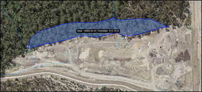
Figure 3. Permitted landfill extension area adjacent to proposal area
|
VEGETATION COMMUNITIES
|
Plant Community |
TASVEG Code |
Status under NCA*and/or EPBCA** |
Area (ha) |
|
E. tenuiramis forest and woodland on sediments |
DTO |
TNVC under NCA |
5 |
|
E. pulchella forest and woodland |
DPU |
Not listed |
5 |
|
E. obliqua dry forest |
DOB |
Not listed |
6 |
|
E. obliqua forest with broad-leaf shrubs |
WOB |
Not listed |
3 |
|
E. globulus wet forest |
WGL |
Not listed |
35 |
|
Total Area (ha) |
54 |
||
*Tasmanian Nature Conservation Act 2002
**Australian Government Environment Protection and Biodiversity Conservation Act 1999
Note: - attach a vegetation map (including location of any threatened species within the proposal area to agreed format and standard).
VEGETATION DESCRIPTIONS
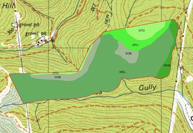
Figure 4. Map of TASVEG communities within the proposal area
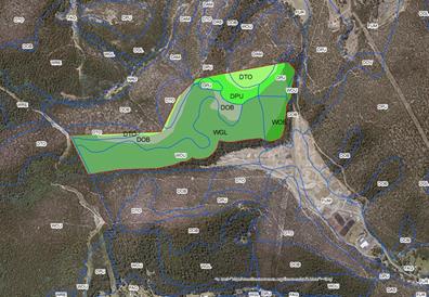
Figure 5. Map of TASVEG communities within the proposal area overlain by TASVEG communities (TASVEG 3) for the local area.
E. tenuiramis forest and woodland on sediments (DTO)
E. tenuiramis forest and woodland on sediments (DTO) occurs mainly on the ridgeline along the northern boundary of the proposal area. TASVEG 3 maps this area as DTO. The forest community is in very good ecological condition.
DTO is dominated by E. tenuiramis with occasional E. viminalis. The forest is multi-aged with abundant regeneration. There is significant bare ground and litter on the forest floor with a sparse cover of flora. The most common shrubs include Exocarpus cupressiformis, Pultenaea juniperina, Aotus ericoides and Daviesia ulicifolia. No invasive species were noted, there was little evidence of grazing and browsing, no erosion and no evidence of timber removal. DTO is susceptible to Phytophthora cinnamomi.
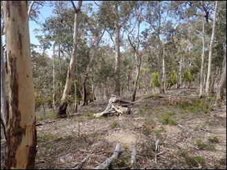
Figure 6. E. tenuiramis forest and woodland on sediments (DTO) within proposal area
E. pulchella forest and woodland (DPU)
E. pulchella forest and woodland (DPU) occurs mainly around the upper slope and transitions to DTO on the hilltop. TASVEG 3 maps most of this area as DPU. The forest community is multi-aged and is in very good ecological condition.
DPU is dominated by E. pulchella with a range of other species, sometimes locally dominant, including E. viminalis, E. globulus, E. amygdalina and E. tenuiramis. Occasional old growth trees are present and the species richness is typical of the community. Common understorey trees and shrubs include Pultenaea juniperina, P. daphnoides, Daviesia ulicifolia, Lomatia tinctoria and Acacia dealbata. The community is grassy and common ground layer species include Austrostipa sp., Austrodanthonia spp., Poa rodwayi, Viola hederacea, Oxalis perennans, Geranium potentilloides, Senecio sp., and Bossiaea prostrata. No invasive species were noted, there was little evidence of grazing and browsing, no erosion and no evidence of timber removal. The community is not susceptible to Phytophthora cinnamomi.
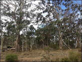
Figure 7. E. pulchella forest and woodland (DPU) within the proposal area
E. obliqua dry forest (DOB)
E. obliqua dry forest (DOB) occurs mainly on the southern slope off the ridge running along the northern boundary of the proposal area. TASVEG 3 maps this area as E. obliqua dry forest (DOB). The forest community is in very good ecological condition.
DOB is dominated by E. obliqua with occasional E. viminalis. Occasional old growth trees are present, with a significant regrowth component, the species richness is typical of the community and there is abundant CWD. Common understorey trees and shrubs include Exocarpus cupressiformis, Olearia viscosa, Pultenaea juniperina, P. daphnoides and Acacia dealbata. No invasive species were noted, there was little evidence of grazing and browsing, no erosion and no evidence of timber removal. DOB is susceptible to Phytophthora cinnamomi.
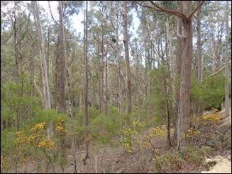
Figure 8. E. obliqua dry forest (DOB) within the proposal area
E. obliqua forest with broad-leaf shrubs (WOB)
E. obliqua forest with broad-leaf shrubs (WOB) occurs mainly along the steep creek gully running down the eastern boundary of the proposal area. TASVEG 3 maps this area as E. obliqua wet forest (WOB) and E. obliqua dry forest (DOB). The forest community is in very good ecological condition.
WOB is dominated by E. obliqua with E. globulus co-dominant, sub-dominant or absent. Occasional old growth trees are present, with a significant regrowth component, the species richness is typical of the community, and there is abundant CWD. Common understorey trees and shrubs include Acacia melanoxylon, Coprosma quadrifida, Pomaderris apetala, Olearia argophylla, Bedfordia salicina, Acacia dealbata and Dicksonia antarctica. The ground cover is dominated by litter and moss, with ferns common including Polystichum proliferum. No invasive species were noted, there is little evidence of grazing and browsing, no erosion and no evidence of timber removal. WOB is not susceptible to Phytophthora cinnamomi.
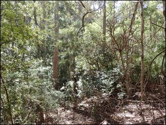
Figure 9. E. obliqua forest with broad-leaf shrubs (WOB) within the proposal area
E. globulus wet forest (WGL)
E. globulus wet forest (WGL) occupies most of the southern portion of the proposal area. TASVEG 3 maps most of this area as E. obliqua wet forest (WOB) however the impression from two transects through the forest indicates a larger portion of this area is dominated by E. globulus rather than E. obliqua. Detailed survey could result in mapping of a mosaic of both communities though WGL better describes the value of this forest community as foraging habitat for the swift parrot.
WGL is dominated by E. globulus with E. obliqua co-dominant, sub-dominant or absent. Occasional old growth trees are present, with a significant regrowth component, the species richness is typical of the community and there is abundant CWD. Common understorey trees and shrubs include Acacia melanoxylon, Coprosma quadrifida, Pomaderris apetala, Olearia argophylla, Acacia dealbata and Dicksonia antarctica. The ground cover comprises mainly litter and moss, with ferns common including Polystichum proliferum. No invasive species were noted, there is little evidence of grazing and browsing, no erosion and no evidence of timber removal. WGL is not susceptible to Phytophthora cinnamomi.
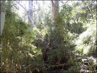
Figure 10. E. globulus wet forest (WGL) within the proposal area
Flora species recorded in the proposal area during inspection
|
Acacia stricta |
Dianella tasmanica |
Oxalis perennans |
|
Acacia dealbata |
Epacris impressa |
Pimelea humilis |
|
Acacia melanoxylon |
Eucalyptus amygdalina |
Poa rodwayi |
|
Acacia terminalis |
Eucalyptus globulus |
Poa labillardieri |
|
Acacia verniciflua |
Eucalyptus obliqua |
Polystichum proliferum |
|
Acacia verticillata |
Eucalyptus pulchella |
Pomaderris apetala |
|
Aotus ericoides |
Eucalyptus tenuiramis |
Pteridium esculentum |
|
Acrotriche serrulata |
Eucalyptus viminalis |
Pultenaea daphnoides |
|
Allocasuarina monilifera |
Exocarpus cupressiformis |
Pultenaea juniperina |
|
Astroloma humifusum |
Geranium potentilloides |
Senecio linearifolius |
|
Austrodanthonia spp. |
Geranium solanderi |
Senecio sp. |
|
Austrostipa sp. |
Gonocarpus tetragynus |
Tetratheca pilosa |
|
Bedfordia linearis |
Goodenia lanata |
Viola hederacea |
|
Bedfordia salicina |
Indigofera australis |
|
|
Beyeria viscosa |
Lagenophora stipitata |
|
|
Bossiaea cordigera |
Leptospermum scoparia |
|
|
Bossiaea prostrata |
Leptorhynchos squamatus |
|
|
Bulbine bulbosa |
Leucopogon collinus |
|
|
Bursaria spinosa |
Leucopogon sp. |
|
|
Cassinia aculeata |
Lomatia tinctoria |
|
|
Coprosma quadrifida |
Olearia argophylla |
|
|
Coronidium scorpioides |
Olearia lirata |
|
|
Daviesia ulicifolia |
Olearia viscosa |
|
THREATENED SPECIES RECORDED IN THE PROPOSAL AREA
|
Species |
Status under TSPA^ / EPBCA** |
Type and Date of Record |
Comments |
|
Flora |
|
|
|
|
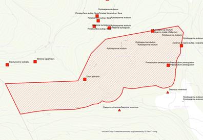
Asperula scoparia subsp. scoparia |
r |
Sighting 27/10/1937 |
(GR GDA 94 523250 5252268 ) Observer: A. M. Olsen (Source: NVA) |
|
Diuris palustris |
e |
Sighting 22/10/1939 |
(GR GDA 94 522432 5219883) Observer: Unknown (Source: NVA) |
|
Epacris virgata (Kettering) |
v |
Sighting 20/10/1995 |
(GR GDA 94 523005 5252392) Single plant to 0.5 m high growing in middle of track. Observer: Richard Schahinger (Source: NVA) |
|
Prasophyllum perangustum |
e/CE |
Sighting 01/01/1996 |
(GR GDA 94 523137 5252102) Observer: A. M. Olsen (Source: NVA) |
|
Rytidosperma indutum |
r |
Sighting 18/07/2010 |
(GR GDA 94 523005 5252392) Observer: Mark Wapstra with 5 m accuracy (Source: NVA) |
|
Fauna |
|
|
|
|
Swift Parrot Lathamus discolor |
e/CE |
Sightings |
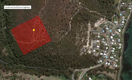
Observations of swift parrot activity within the forest block in years when E. globulus is flowering (Matt Webb pers. comm.) |
|
Eastern Quoll Dasyurus viverrinus |
E |
Sightings |
Observed in recent years by remote camera along the southern boundary of the proposal area Observers: Billie Lazenby & Lisa Cawthen |
^Tasmanian Threatened Species Protection Act 1995
**Australian Government Environment Protection and Biodiversity Conservation Act 1999
|
GENERAL COMMENTS ON THREATENED SPECIES NOTING LEVEL OF SURVEY EFFORT
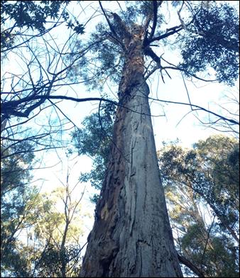
Figure 11. Old growth E. globulus tree within the proposal area supporting potential hollows for swift parrot
Figure 12. Threatened flora and fauna recorded from the vicinity of the proposal area.
|
THREATENED SPECIES NOT OBSERVED IN THE PROPOSAL AREA BUT WHICH MAY OCCUR IN THE PROPOSAL AREA BASED ON THE PRESENCE OF SUITABLE HABITAT OR OTHER INFORMATION
|
Species |
Status under TSPA^ / EPBCA** |
Type and Date of Record |
Comments |
|
Fauna |
|
|
|
|
Tasmanian devil Sarcophilus harrisii |
e/E |
|
Potential habitat present |
|
Spotted-tailed Quoll Dasyurus maculatus |
r/V |
|
Potential habitat present |
|
Masked owl Tyto novaehollandiae |
e/V |
|
Potential habitat present |
^Tasmanian Threatened Species Protection Act 1995
**Australian Government Environment Protection and Biodiversity Conservation Act 1999
A current Natural Values Report should be attached with this form. Threatened species records must also be provided directly to the Natural Values Atlas.
|
IS THERE AN EAGLE’S NEST WITHIN 1KM OF THE PROPOSAL AREA? |
No. Nearest nest is 6.0 km to the NW
|
|
ARE THERE ANY FEATURES OF GEOLOGICAL OR GEOMORPHOLOGICAL SIGNIFICANCE? |
No.
|
|
ARE THERE ANY OTHER FEATURES OF NOTE? |
No.
|
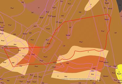
Figure 13. Proposal
area overlaid on 1:25,000 geology mapping
PART THREE: THREATS AND MANAGEMENT ISSUES
|
Issue |
Commentary |
|
WHAT ARE THE THREATS TO NATURAL VALUES? |
Weeds. There is an ongoing threat of the introduction of weeds through wind and animal dispersed seed. No significant weeds were detected during surveys of the proposed covenant area. Two dead gorse plants were encountered that had obviously been sprayed. Holcus lanatus and Dactylis glomerata were detected but were rare within the proposal area.
|
|
WERE ANY WEEDS RECORDED IN THE PROPOSAL AREA? |
No.
|
|
DO ANY FERAL ANIMAL SPECIES OF CONCERN OCCUR IN THE PROPOSAL AREA? |
No. It is likely feral cats occur in the proposal area though no evidence of scats was encountered during surveys. |
|
WAS ROOT-ROT FUNGUS (Phytophthora cinnamomi) RECORDED IN THE PROPOSAL AREA? |
No. |
|
ARE ANY OF THE VEGETATION COMMUNITIES IN THE PROPOSAL AREA SUSCEPTIBLE TO ROOT-ROT FUNGUS? |
Yes. |
|
ARE THERE ANY OLD DUMP SITES IN THE PROPOSAL AREA? |
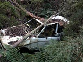
No. However a dumped car was noted in the creek on the eastern boundary of the proposal area.
|
PART FOUR: PROPOSAL DETAILS FOR TERMS OF COVENANT AND NATURE CONSERVATION PLAN
A management map should be attached with this form, which should include locations of existing and proposed infrastructure such as tracks, fences and pipelines; watercourses and dams; and weeds etc.
Note to drafters: Delete options in right hand column that are not required, prior to submitting to PAG.
DOMESTIC ZONE (if applicable)
|
Item |
Proposed Terms and Conditions |
|
DOMESTIC ZONE
|
No. |
CONSERVATION ZONE
|
Item |
Proposed Terms and Conditions |
|
THREATENED AND/OR PRIORITY SPECIES - Specific management prescriptions |
No specific management prescriptions required. |
|
TIMBER HARVESTING |
Not permitted. |
|
DOMESTIC FIREWOOD |
Not permitted. |
|
STOCK GRAZING |
Not permitted. |
|
EXISTING FENCING |
Yes · The boundary of the Proposal Area with McRobies Landfill Area is fenced and the fence is in good condition. This fence will be maintained. · There are no other fences in the proposal area. |
|
NEW FENCES PROPOSED OR REQUIRED |
No. |
|
FUEL REDUCTION AND ECOLOGICAL BURNS |
Authorisations provided - the Owner may use fire to achieve fire hazard reduction if and when the Owner and the Minister, or the Tasmania Fire Service deem it necessary for safety reasons, and the Owner may use fire to conduct ecological burns for management of biodiversity. |
|
CAMPFIRE(S) |
Not permitted. |
|
PERMANENT FIREBREAKS |
Authorisation for construction and maintenance of permanent firebreaks is to be provided for the following: · If and when the owner and the Minister, or the Tasmanian Fire Service deem it necessary. |
|
EMERGENCY FIREBREAKS |
Emergency firebreaks will be permitted if there is an immediate threat to life or property. |
|
HERBICIDES, PESTICIDES, FERTILISERS AND OTHER CHEMICALS |
The owner may use herbicides on the land as part of a weed management program. Pesticides may only be applied on the land if required as part of a feral animal management program. |
|
CONTROL OF EXOTIC PLANT SPECIES (WEEDS) |
The owner will make annual inspections and control and (if possible) eradicate infestations of environmental weeds (see detail provided in Part 3 above). |
|
CONTROL OF EXOTIC (FERAL) ANIMAL SPECIES |
The owner is responsible for the control or eradication (if feasible) of feral animals on the land. |
|
CONTROL OF NATIVE ANIMALS |
Not permitted. |
|
WILL DOGS OR HORSES BE ALLOWED INTO THE PROTECTED AREA? |
Yes · Dogs under effective control for recreation. Note. Dogs must not cause harm to native animals or their habitat. |
|
INTRODUCTION OF NATIVE FLORA FOR THE PURPOSE OF REVEGETATION |
No. · Authorisation will be sought if revegetation is required in the future. |
|
TAKING OF WATER FOR DOMESTIC USE |
No. |
|
NATURAL FLOW OF WATER |
Minor interference with the natural flow of water is permitted where it is associated with existing carriageways, dams and infrastructure (e.g. buildings in a domestic zone). |
|
EFFLUENT AND IRRIGATION |
The use of irrigation water or effluent of any kind is prohibited on the land. |
|
ARE THERE EXISTING VEHICLE OR WALKING TRACKS? |
Yes · Vehicle tracks. These tracks will be maintained. · Walking tracks. These tracks will be maintained.
|
|
NEW VEHICLE TRACKS |
No new carriageways are permitted. · New vehicle track/s may be required in the future for the purpose of management but the location of vehicle tracks will be subject to approval by the Minister after consultation with the owner.
|
|
NEW WALKING TRACKS |
· New walking track/s may be constructed in the future but the location of the walking track(s) will be subject to approval by the Minister after consultation with the owner.
|
|
OFF-ROAD VEHICLE USE |
With the exception of emergencies (medical evacuation, bushfire) off-road vehicle use will only be permitted: · To assist with approved construction activities · To assist with approved maintenance activities · To assist with weed control activities
|
|
RECREATIONAL USE |
Recreational activities that are not considered deleterious to the natural values are permitted on the land.
|
|
DELETERIOUS ACTIVITIES |
No activities (including, but not confined to removal of natural resources, dumping of rubbish, general disturbance etc) which are or may be considered deleterious to the natural values are permitted on the land unless approved by the Minister.
|
|
IS THERE ANY OTHER EXISTING INFRASTRUCTURE (e.g.: Caravan, shed, powerlines, pipeline, water tank) THAT HAS NOT BEEN COVERED ABOVE? |
Yes. Power transmission lines pass through the western portion of the proposal area. See proposal area map.
|
|
CONSTRUCTION OF INFRASTRUCTURE |
Construction of new infrastructure is not permitted. NB Where infrastructure locations have not been decided, the location(s) of the infrastructure will be subject to approval by the Minister after consultation with the owner.
|
|
INTRODUCTION OF FOREIGN MATERIALS |
Introduction of foreign materials (e.g. gravel for road maintenance) is only permitted with the authorisation of the Minister.
|
|
ARE THERE ANY ADDITIONAL ISSUES NOT COVERED BY THE STANDARD CLAUSES? |
No. |
PART FIVE: DECISION OF PROPERTY ASSESSMENT GROUP
Date assessed by the Property Assessment Group (PAG):
PAG members present at meeting:
Decision and any conditions:
IUCN category recommendation:
|
IUCN category |
Description |
PAG decision |
|
Ia
Strict Nature Reserve |
Strictly protected areas set aside to protect biodiversity and also possibly geological or geomorphological features, where human visitation, use and impacts are strictly controlled and limited to ensure protection of conservation values. These reserves require minimal management. Such protected areas can serve as indispensable reference areas for scientific research and monitoring. Note. These areas can be small. |
|
|
1b
Wilderness Area |
Large unmodified or slightly modified areas, retaining their natural character and influence, without permanent or significant human habitation, which are protected and managed so as to preserve their natural condition. These reserves are usually large and are free of infrastructure such as roads and power lines. |
|
|
III
Natural Monument |
Areas set aside to protect a specific natural monument, which can be a landform, geological feature such as a cave or even a living feature such as an ancient grove. They are generally quite small protected areas and often have high visitor value. These reserves are usually small, and focus on the protection of particular natural features rather than on the protection of key species or habitats. Note. An example would be a reserve established primarily to protect an area of karst. |
|
|
IV
Habitat/ Species Management Area |
Areas set aside to protect particular species or habitats and management reflects this priority. Many category IV protected areas will need regular, active interventions to address the requirements of particular species or to maintain habitats, but this is not a requirement of the category. These reserves are often small, and commonly occur in a fragmented landscape. Note. The majority of covenants would qualify as category IV protected areas, as they have been established to protect habitat for flora and fauna. In addition, those reserves that have been established primarily to protect species such as wedge-tailed eagles (nesting sites) would also qualify. |
|
Priority:
|
Priority |
Description |
PAG decision |
|
1 |
Area makes an essential contribution to CAR requirements |
|
|
2a |
Area makes a very high contribution to CAR requirements |
|
|
2b |
Area makes a high contribution to CAR requirements |
|
|
3 |
Area makes a moderate contribution to CAR requirements |
|
|
4 |
Area makes a low contribution to CAR requirements but should be included at minimal cost |
|
|
5 |
Area makes a low contribution to CAR requirements and should be referred to other programs |
|
|
6 |
Area makes a very low contribution to CAR requirements and no further action is required. |
|
Signed (by PAG Chair) and dated:
|
Agenda (Open Portion) City Infrastructure Committee Meeting |
Page 31 |
|
|
|
30/5/2018 |
|
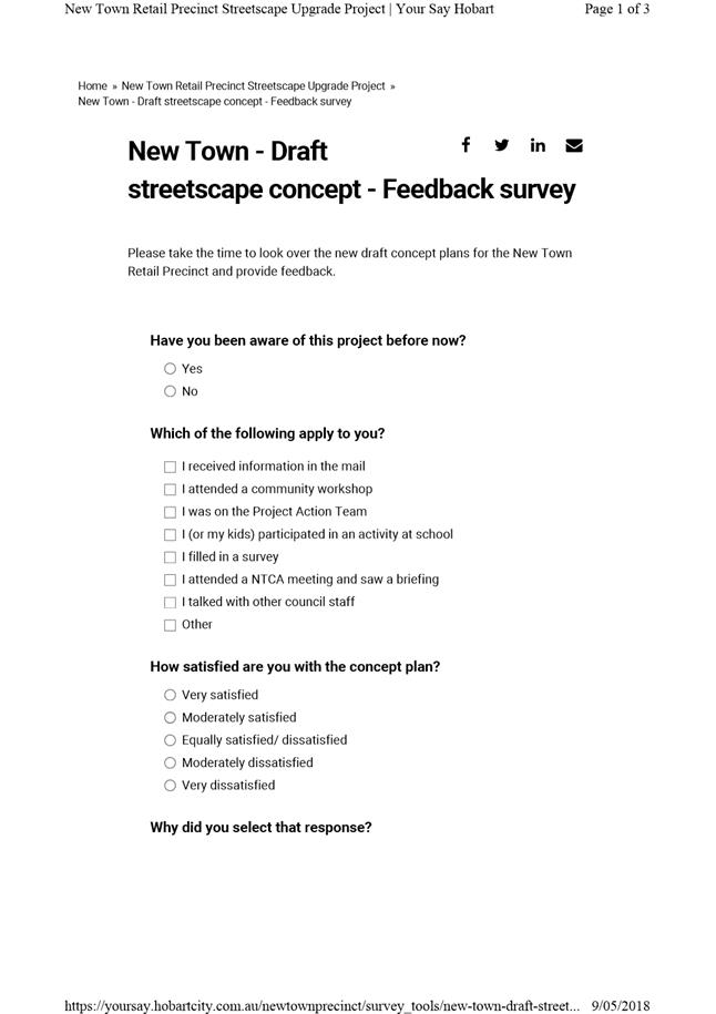
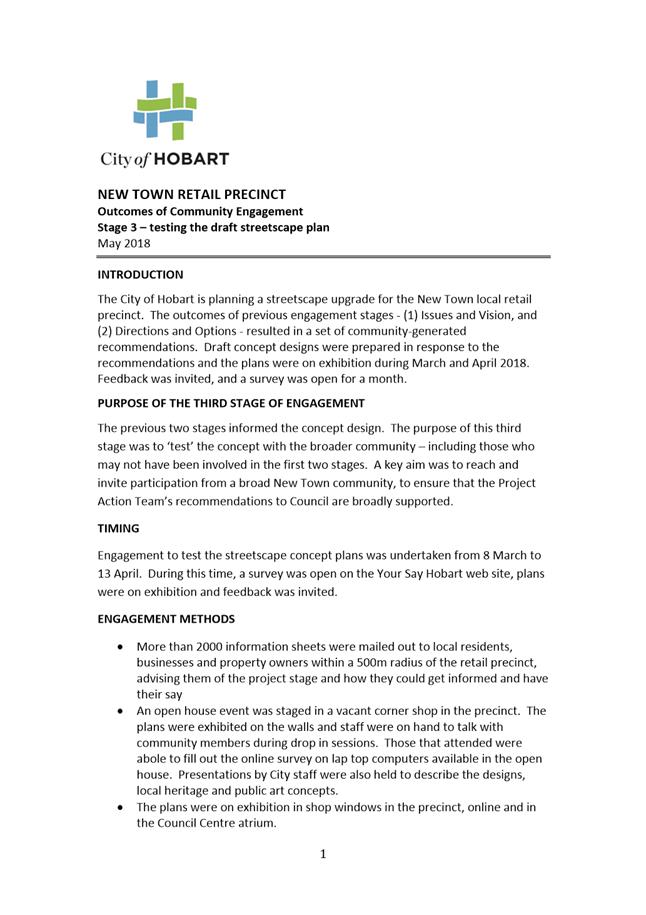
6.2 New Town Retail Precinct - Proposed Streetscape Concept
Report of the Manager Traffic Engineering and the Director City Infrastructure of 25 May 2018 and attachments.
Delegation: Council
|
Item No. 6.2 |
Agenda (Open Portion) City Infrastructure Committee Meeting |
Page 32 |
|
|
30/5/2018 |
|
REPORT TITLE: New Town Retail Precinct - Proposed Streetscape Concept
REPORT PROVIDED BY: Manager Traffic Engineering
Director City Infrastructure
1. Report Purpose and Community Benefit
1.1. This report presents a proposal for streetscape improvements in the New Town retail precinct.
1.2. The proposed streetscape improvements will provide better access and amenity for pedestrians, making it easier for people to safely and comfortably access the shops, services and public transport in New Town Road, between Pedder Street and Risdon Road.
2. Report Summary
2.1. The City’s design team has developed a draft streetscape plan for the New Town Retail Precinct, based on the New Town community Project Action Team’s recommendations and priorities.
2.2. The plan has been tested with the New Town community and other stakeholders, using an extensive engagement program to ensure that all stakeholders have had an opportunity to consider the proposal and have their say.
2.3. The proposal comprises improvements at various ‘nodes’ along the 900m stretch of New Town Road, including Pedder Street, Pirie Street, near the Salvos and Greenstore, Roope Street, Cross Street and near Woolworths. There will be renewed footpaths throughout the precinct linking these nodes.
2.4. There is an emphasis on improved pedestrian amenity and access, with new and improved crossing facilities on New Town Road and raised threshold treatments at the side streets, as these were the community’s highest priority.
2.5. Included in the proposal will be a public art commission, street trees and planting beds, new street furniture, paving and heritage interpretation.
2.6. Results of the consultation indicates that support for the concept design is about 69%. Most comments were positive, with people generally welcoming of the improvements to pedestrian infrastructure and looking forward to a fresh appearance in the main street. The most common reason for dissatisfaction was related to the approach to bicycle infrastructure.
2.7. Most traders who are near the proposed works have indicated support for the changes, however some have expressed concerns about car parking availability during construction and to a lesser extent, after the changes.
2.8. The proposal is subject to planning approval, and the raised threshold elements subject to Transport Commissioner approval.
2.9. The project cost is estimated at $2.7 million, with a $700,000 component of planned renewals to be funded from renewal budget and $2 million from the Transforming Hobart budgets of 2018-2019 and 2019-2020.
|
That: 1. The Council receive and note the draft streetscape plan for the New Town retail precinct, which has been prepared in response to the recommendations of the New Town community’s Project Action Team. 2. The Council receive and note the results of the consultation which has been undertaken to test the concept designs with the wider community. 3. The streetscape upgrade be implemented, based on the concept design proposal, with detailed design to be undertaken in 2018 and construction to commence in early 2019.
|
4. Background
4.1. In December 2015, the Council endorsed a plan to upgrade a series of local retail precincts across Hobart. A Plan for Hobart’s Local Retail Precincts (the plan) was prepared by a consultant team including MRCagney, Inspiring Place, Village Well, Jon Mongard Landscape Architects and Fresh Start Communications.
4.2. The Lenah Valley precinct will be the first of the upgrades from the plan to be completed with construction well underway.
4.3. New Town is the next precinct to be progressed, with construction planned to commence in early 2019.
4.4. The concept design proposed in the consultant’s plan for New Town featured a pedestrian plaza with vehicle traffic disallowed in the junction area between Cross Street, Valentine Street and the western side of New Town Road. While the concept was embraced by many, it was strongly opposed by a number of stakeholders including some traders and property owners in the immediate vicinity, who would have been most affected by such change.
4.5. After discussions with the New Town Community Association and other key stakeholders, a new program of engagement was launched in July 2017 that invited collaboration with the community and considered other options for the retail precinct upgrade.
4.6. The project was ‘relaunched’, and the first stage included an information mail out to over 2000 properties in New Town, an online survey and a facilitated, open invitation community workshop held at Sacred Heart College. The objective of that first stage of engagement was to gather the community’s burning issues and aspirations, and identify common ground which was important to move the project forward with support.
4.7. Following the first stage, 23 local community members joined a Project Action Team (PAT) to work closely with Council staff in a deliberative planning process which would re-define the scope of the project.
4.8. PAT members participated in four intensive, facilitated workshops where information was presented, issues and ideas discussed, objectives ranked and outcomes deliberated.
4.9. The culmination of the process was a report written by the Project Action Team, containing 32 recommendations. Each recommendation received super majority support (80% or greater). PAT members presented this report to Aldermen in a workshop at the Town Hall held on 22 November 2017.
4.10. A report was then provided to the City Infrastructure Committee at its meeting held on 6 December 2017, outlining the results of the PAT process titled “New Town Retail Precinct – results of community engagement”.
4.11. At its meeting of 18 December 2017 the Council resolved inter alia the following:
That: 1. The recommendations from the New Town Project Action Team form the basis of a new scope for streetscape improvements in the New Town Retail Precinct
2. A draft streetscape plan be developed based on the Project Action Team’s priorities, for wider community consultation around March 2018.
4.12. A draft streetscape plan was developed for the New Town Retail Precinct upgrade, by the Council’s design team, based on the PAT’s recommendations and priorities.
4.13. The plan was presented to the PAT for their approval prior to a public exhibition period.
4.14. With the PAT’s approval, the draft plans were shared with the public in March and April 2018 to test the new concepts with the broader community. The draft streetscape plans are included as Attachment A. Engagement activities included:
4.14.1. A project bulletin emailed to all stakeholders on the contact list – with a schedule of events and invitation to attend the open house event.
4.14.2. A presentation to the New Town Community Association at their AGM held at the New Town Bowling Club, followed by a community Q and A.
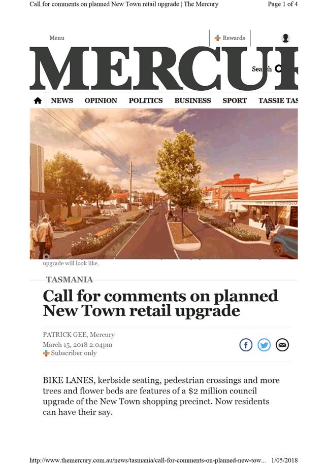
4.14.3. A media release and article in the Mercury to promote the engagement (refer Attachment B).
4.14.4. Promotion of the engagement on the Council’s Facebook page.
4.14.5. A three day Open House event held in a vacant shop on the corner of Roope Street and New Town Road – in the heart of the precinct. The plans (refer Attachment A) along with background information (refer Attachment C) were exhibited in the shop and over 300 locals attended to view the plans, attend presentations, talk with council staff and fill out surveys.
4.14.6. A temporary parklet installation in Roope Street as part of the Open House event. This demonstrated the proposed parklet and kerb bulbing in situ. Traffic observations were undertaken in the week following the open house during morning peak, to assess the impacts of the parklet on traffic movement.
4.14.7. Exhibition of the draft streetscape plans at the Sacred Heart College twilight fair – City staff set up a stall at the fair to display the plans, conduct surveys and talk with families.
4.14.8. Online exhibition of the draft streetscape plans Your Say Hobart until mid-April. A survey was open for one month and the designs and background information continues to be available for those who need more information.
4.14.9. The online survey (refer Attachment D) was used to gauge levels of support for the project (quantitative) as well as to gather detailed feedback regarding the proposal (qualitative).
4.14.10. Exhibition of the draft streetscape plans for a month in New Town shop windows and the Hobart Council Centre atrium. Hard copy surveys were also available.
4.14.11. Meetings with relevant stakeholders including Metro Tasmania, Bicycle Network and Department of State Growth.
4.15. Every attempt has been made to contact and engage with all stakeholders in the precinct, to explain the proposal, gauge support and give opportunities to raise concerns and questions. Contact has been made by post, email, telephone and/or face to face.
5. Outcomes of the community engagement
5.1. A detailed summary of the engagement outcomes is presented in Attachment E.
5.2. 145 responses were received to the online survey.
5.3. Among survey respondents, 69% were satisfied with the plan, 22% were dissatisfied and 9% were equally satisfied/dissatisfied.
5.4. Survey comments, submissions, conversations and emails have been received and considered. Detailed responses to the issues raised are provided in Attachment E.
5.5. In summary, the main themes have been considered in the following way:
5.6. The most frequently raised feedback themes are outlined below:
(i) Positive feedback, praise for the concept (61 survey comments, 3 emails).
(ii) Requests for better provision for bicycles (21 survey comments, 2 submissions).
(iii) Concerns about impacts on congestion (8 survey comments).
(iv) Disappointed that access to Valentine and Cross Streets will not be restricted (7 survey comments).
(v) Requests for less provision for bikes (5 survey comments).
(vi) Not wanting the Roope Street outbound bus stop to be removed (5 comments).
(vii) Concerned about the current location of the inbound bus stop at Roope Street and impacts on traffic delays (5 comments).
6. Proposal and Implementation
6.1. The proposal has been developed in collaboration with the New Town community, and includes inputs from local traders, residents, institutions and local school communities. The concept design responds directly to the recommendations and priorities of the Project Action Team. The PAT’s recommendations can be found in the Background Report (refer Attachment C).
6.2. Diverse road user perspectives have also been provided by: the Access Advisory Committee, the Hobart Bicycle Advisory Committee, Metro Tasmania, and Department of State Growth. Professional advice was provided by consultants in traffic modelling and bicycle infrastructure.
6.3. The proposal comprises improvements at various ‘nodes’ along the 900m stretch of New Town Road, between Pedder Street and Risdon Road, with improvements to footpaths throughout.
6.4. Each key node is described below, and the plans marked in Attachment A provide an illustrated summary. Where stakeholder concerns have been raised about specific aspects of the proposal, these are reported within the description of each node, along with a description about how the feedback has been considered by the project team, including suggested design changes, results of observations and additional information that may be relevant for the Council to consider when making its decision.
6.5. Node 1: Northern Gateway: The PAT identified the area near Woolworths, to be the ‘northern gateway’ to the precinct. The proposed treatment here is to enhance the presentation of the streetscape, to indicate to drivers arriving from the north that they are entering an activity zone, calm traffic and improve pedestrian access. Design features include:
6.5.1. An improved pedestrian crossing facility near Woolworths with a wider median island and a kerb outstand on the eastern side to make the crossing facility more accessible.
6.5.2. Trees in the central median and low growing plants in the footpath edges to provide a softer, greener entry point to the busy activity area, calming traffic and defining the gateway. The placement and installation of the trees will be subject to detailed design. It will be important to ensure safe sight distances between drivers and pedestrians, safe lighting levels, access by oversized vehicles and a tree installation method that minimises impacts on traffic flows in New Town Road during construction.
6.5.3. A seat and renewed planting will provide an opportunity for rest. This is suggested on Woolworths land and will be subject to consultation with Woolworths (discussions have commenced).
6.5.4. A short section of bicycle lane avoids a pinch point for cyclists in the uphill direction alongside the median island. Note: a continuous bike lane throughout the precinct is not proposed. The approach to bicycle infrastructure is discussed at 6.11.
6.6. Node 2: Cross Street and Valentine Street junction: The junction of Cross and Valentine Streets is the historic heart of New Town. The proposal retains vehicle access through the intersection, as recommended by the PAT. A safe pedestrian crossing on New Town Road near the historic Post Office emerged as a high priority for the community. Design features include:
6.6.1. Day-to-day traffic access remains unchanged, however a raised level platform will be installed where Valentine and Cross Streets converge, to improve pedestrian accessibility.
(i) Removable bollards with additional sockets would enable the space to be used as a pedestrian-only event space on occasion.
(ii) Public art is proposed for this location. It would have built-in power sockets to support events, seating and poster pole elements. The public art component of the project is discussed in clause 6.15.
6.6.2. A raised threshold on the eastern side of New Town Road, between Crowther Richards Real Estate and Lebrina Restaurant, will improve pedestrian access.
6.6.3. A new pedestrian crossing facility with median island and kerb outstands is proposed north of Cross Street, near the historic Post Office. There is currently no crossing point in this location and yet a significant number of pedestrians have been observed crossing the road here. The location emerged during consultation as a high priority for a safe crossing point.
(i) To install a pedestrian crossing point would require the loss of approximately two car parking spaces in front of the old Post Office and one car parking space in front of Crowther Richards Real Estate Agency.
(ii) The two car parking spaces in front of Archive Antiques will be retained, and the proposed kerb bulbing will be in front of Post Office 176 / Dispatch Café.
(iii) The loss of car parking in this vicinity would be offset by up to four additional on-street parking spaces that will become available with Metro’s proposed removal of the inbound bus stop adjacent to 159B New Town Road, near the Chinese Restaurant. (All changes to bus stops are explained at 6.12).
(iv) The proposed new pedestrian crossing point would make it easier for people using those new parking spaces to access the businesses opposite.
(v) In summary, a high quality pedestrian crossing facility could be provided with no net loss of car parking because of the planned removal of a bus stop in the vicinity.
6.6.4. The existing signalised crossing between Cross Street and Roope Street is well used and provides pedestrian priority in the middle of the precinct. It would be retained.
6.6.5. The outbound bus stop would remain near Cross Street.
(i) A new shelter is proposed to improve amenity for people waiting for the bus. Adjacent property owners of 21 Cross Street have provided in-principle support, and discussions have begun regarding the design and placement of the shelter.
(ii) Should the Council resolve to progress the precinct upgrade, an appropriate legal agreement would be negotiated to enable the installation of the shelter and the public use of a small area of the property adjacent to the footpath.
6.6.6. Bike racks, bins and seating are proposed for the area. Their precise locations will be determined during detail design, in consultation with adjacent traders and owners.
6.7. Node 3: Roope Street junction: The Roope Street corner is characterised by significant heritage architecture including the current Skin Cancer Clinic (old bakery), the Talbot Hotel, pharmacy and newsagency, a currently vacant old corner store and the nearby former Town Hall. The improvements at the Roope Street node are focused on improving pedestrian access, enhancing the appearance and amenity of the area, and improving traffic arrangements at the intersection. The design features include:
6.7.1. A small parklet is proposed by extending the footpath into Roope Street providing space for a tree, planting and a seat. The parklet would require removal of one on street car parking space. The proposed arrangement would provide a better alignment of the intersection, improving drivers’ sight distances and make it simpler and safer for pedestrians to cross.
6.7.2. A temporary parklet was trialled for a week as part of the open house, providing the opportunity to observe the traffic and pedestrian movements in the morning mid-week peak period. The narrowing of Roope Street did not create any unacceptable levels of queuing or delays.
6.7.3. Continuous level footpath thresholds are proposed to provide a level, step free path for pedestrians crossing Roope Street – on the south west side between the vacant shop and New Town Motors, and on the north east side between the Skin Cancer Clinic and the Talbot Hotel.
6.7.4. An improved pedestrian crossing facility with a median island and a kerb outstand outside the vacant shop is proposed, to be co-located with the inbound bus stop to improve pedestrian access in this busy crossing location.
6.7.5. The kerb outstand would require the loss of approximately 3 metres of kerbside car parking space. This amounts to half a car parking space, leaving sufficient space for two large vehicles or perhaps three compact vehicles to park in front of the corner shop and the Cat Clinic. The Cat Clinic does have off street parking, and there is parking available on street in Roope Street.
6.7.6. The inbound bus stop is proposed to remain in the location near the Skin Cancer Clinic.
(i) The Roope Street inbound bus stop is one of the busier stops on the route, as it services Sacred Heart College, the surrounding residential area and the services and shops in the retail precinct. In its current location the shop awnings provide good protection from the weather and some seating for people waiting for buses.
(ii) City staff have met with Metro’s planners to ensure that appropriate lane widths are provided. The designed lane widths have been tested, adjusted slightly and are technically compliant. Furthermore, buses are only stopped at the kerb for short periods every ten minutes or so, meaning that any delays caused if a vehicle decides to wait are minor.
6.7.7. The Skin Cancer Clinic has requested an on street parking space for people with a disability. Opportunities to provide accessible parking will be investigated during detailed design.
6.7.8. Right turn lanes are proposed in the centre of the road to assist with traffic turning movements. This is consistent with the ‘black spot’ treatment recently installed at Cross Street. The PAT recommended prohibiting right turn movements into Roope Street. However, as this would significantly reduce access to the neighbourhood streets, turning lanes were proposed as an alternative measure. This approach was accepted by the PAT.
6.8. Node 4: Salvos mid-block crossing and pocket park: Community engagement revealed a strong desire for a pedestrian crossing facility in this busy mid-block location. Another priority of the community was for public spaces that could be used for people to stop, rest and spend time. An existing garden on the Salvation Army site in this area presents an opportunity to provide a small space (in agreement with the Salvos) for people to gather.
6.8.1. A new mid-block median pedestrian crossing facility would connect the Salvation Army and New Town Greenstore. A central median island and kerb outstands would make it easier for people to safely cross the road. Nearby stakeholders have expressed support for this proposal including the Greenstore, the Salvation Army and Sultan Holdings (owner/developer of 119 New Town Road).
6.8.2. The Salvation Army (property owners at 115-117 New Town Road) has provided in-principle support for the garden area to be used as public open space. Should the Council resolve to progress the precinct upgrade, an appropriate legal agreement would be negotiated to enable the public use of the area, the removal of a low wall near the footpath, installation of an outdoor table tennis table and/or public artwork.
6.8.3. The proposed works at the Salvation Army site is subject to planning approval.
6.8.4. A short section of bicycle lane avoids a pinch point for cyclists in the uphill direction alongside the median island (note: a continuous bike lane is not proposed. Bicycle infrastructure is discussed at clause 6.11 below).
6.8.5. Water bubbler, feature paving, seating, bike parking and planting would be included in this node, their exact locations to be determined in consultation with adjacent property owners and traders.
6.8.6. The draft streetscape concept plans indicated a proposal for street trees in the median island in this location. Further work has revealed constraints related to access requirements for oversized vehicles and lighting standards. These constraints can’t be ‘designed around’ and therefore the trees in the central median island shown in the draft streetscape plans are not proposed.
6.9. Node 5: Pirie Street junction: The Pirie Street corner is the southern gateway of the New Town retail precinct. The proposed improvements here will enhance the presentation and identify of the street, improve pedestrian access and comfort, and create a place for pedestrians to stop and rest.
6.9.1. A raised threshold is proposed, with associated kerb bulbing and realignment of the Pirie Street intersection with New Town Road. This will have real benefits for pedestrians and especially those using wheelchairs.
6.9.2. Seating, planting, a public art installation and feature paving are proposed, creating a space for people to stop and pause and also enhancing the sense of identity at the gateway to the retail precinct.
6.9.3. The inbound bus stop is proposed to remain in this location near Dapper Dog Grooming. A bench seat will be installed near the bus stop, the final location to be determined in consultation with the nearby traders and property owners.
6.9.4. Renewed paving, bike parking and planting areas will rejuvenate the retail node.
6.9.5. A bicycle lane is proposed in the city-bound direction between Pirie Street and Argyle Street. (Note: a continuous bike lane is not proposed. Bicycle infrastructure is discussed at clause 5.11 below).
6.10. Node 6: Pedder Street junction: The Pedder Street junction, while not within the retail precinct, is proposed to be upgraded to improve pedestrian access.
6.10.1. A raised threshold with kerb bulbing to narrow this one-way side street is proposed at Pedder Street to improve safety and accessibility of this crossing.
6.10.2. Low planting and a bench seat would provide a place for pedestrians to rest.
6.11. Bicycle infrastructure in the precinct
6.11.1. New Town Road is identified as part of the northern route in the City of Hobart’s principle bicycle network plan, however, due to a number of constraints and following expert advice, continuous bicycle lanes are not proposed. An alternative approach is proposed to cater for existing bicycle riders and encourage new bicycle riders.
6.11.2. New Town Road is a busy, high-volume arterial road, carrying in the order of 17,000 vehicles per day. On street parking supports the local businesses and Metro Tasmania’s high frequency ‘Turn up and go’ service provides a well-used public transport service along the corridor. The Department of State Growth is currently working towards achieving a range of optimisation measures along the Main Road transit corridor to enhance the bus service.
6.11.3. Included in the precinct upgrade proposal for bike riders is:
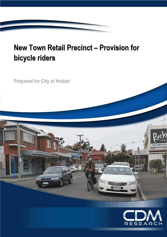
(i) Signposting of the alternative quiet routes identified in the CDM Research report (refer Attachment F).
(ii) To the west, Pedder and Clare Streets – joining New Town Road at Augusta Road and then connecting to either Commercial Road or Argyle Street.
(iii) To the east, Pirie Street provides a quiet, direct and traffic-calmed ‘bypass’ of New Town Road between Risdon Road and the southern end of the precinct. It also provides good connections, which would be improved with wayfinding, to the Inter City Cycleway via Cross and Bay Streets.
(iv) Recognising that some riders already use and will continue to use New Town Road, the following infrastructure is proposed as part of the Retail Precinct project.
(v) Short sections of bicycle lane to ensure that new medians and kerb outstands that are proposed avoid creating pinch points for riders on New Town Rd travelling in the uphill / towards the city direction.
(vi) In the downhill direction (towards Glenorchy), riders are expected to ‘take the lane’.
(vii) An uphill (inbound) bike lane between Pirie Street and Argyle Street.
(viii) Bike parking is also proposed.
6.11.4. It is noted that the City’s Hobart Bicycle Advisory Committee is currently undertaking planning work to scope a new Bike Plan for the City of Hobart. Additional actions to improve the network of bicycle infrastructure in New Town (and other neighbourhood areas) would likely be part of that Plan.
6.12. Proposed changes to bus stops throughout the precinct
6.12.1. Page 2 of Attachment B shows the proposed changes to bus stops and associated infrastructure. In summary, it is proposed to:
(i) Reduce the number of bus stops in the precinct by two – one each in the inbound (near Cross Street) and outbound (Roope Street) directions.
(ii) Retain the other stops in their current locations.
(iii) Relocate an inbound bus stop, from its current location north of Risdon Road, to south of Risdon Road. This location provides access to space for a bus shelter and greatly improved access to New Town plaza. Metro Tasmania has agreed to install a new bus shelter at this stop.
(iv) The result of these changes is that there would be a bus stop in both inbound and outbound directions at the northern end of the precinct (near Risdon Road), at the southern end of the precinct (near Pirie Street) and in the middle (between Cross and Roope Streets). The bus stops are placed approximately 400 metres apart, which is considered good practice from a walkability perspective and provides Metro with the efficiencies they are seeking to achieve.
(v) Additionally, a new bus shelter is proposed to be installed as part of the Retail Precinct upgrade (subject to agreement of the adjacent property owners, at the Cross Street outbound bus stop).
(vi) Install a new bench seat at the inbound bus stop at the southern end of the precinct near Pirie Street.
6.12.2. These proposed changes were included in the draft for consultation, however ultimately the location of bus stops is the responsibility of Metro Tasmania. A summary of the feedback received in relation to the bus stop changes has been provided to Metro Tasmania for their consideration and to assist with decision making.
6.13. Proposed improvements to pedestrian crossings
6.13.1. Page 2 of Attachment B shows the precinct-wide approach to provision of pedestrian crossings. In summary, the proposal would:
(i) Retain the signalised pedestrian crossings at the south (Pirie Street) and in the centre of the precinct (between Cross and Roope Streets). Traffic signals at Risdon Road also include pedestrian facilities.
(ii) Install two new median island pedestrian crossings with kerb outstands in high-use areas – one near the old Post Office and one near the New Town Greenstore.
(iii) Upgrade two existing median crossings to improve accessibility, with kerb outstands and wider medians, near Woolworths and north of Roope Street.
(iv) Remove the sub-standard median crossing point south of Roope Street.
(v) Retain the existing median in its current form, between Woolworths and Risdon Road.
(vi) Install six new raised thresholds on the side streets at Cross Street (both sides), Roope Street (both sides), Pirie Street (city end) and Pedder Street.
6.14. In addition to the specific upgrades at each of the nodes, footpaths throughout the precinct will be replaced or upgraded. A number of these are planned asset renewals and will therefore be funded as such.
6.15. The public art commission
6.15.1. An integrated public art commission is a component of the New Town Retail Precinct Upgrade. While the full detail of the proposed artwork will be the subject of a future report to the Community, Culture and Events committee, the following provides a summary of the process to date:
(i) The process for selecting an artist has paralleled the later stages of progression of the community engagement work on the project.
(ii) Once community priorities were established for the project, a commissioning brief was advertised nationally, with three artists shortlisted by a panel comprising members of the Project Action team; the Public Art Advisory Panel; the City’s design/planning team and the City’s Public Art team.
(iii) Shortlisted artists were each paid to prepare a concept.
(iv) Shortlisted artists participated in a comprehensive briefing day that included sessions with the design team, the public art team, the children and families team, the community engagement team and members of the New Town community, and also a site walk.
(v) Matt Drysdale was selected as the artist for the project by the same panel.
(vi) The budget for the project was originally set at $55,000 (including shortlist fees of $4500), which comprised $15,000 from the Public Art Budget and $40,000 from the overall infrastructure budget.
(vii) With recognition of both the scale of the precinct and ambition of the selected concept, the Public Art budget contribution is now $35,000 (through a redistribution of project funds from next financial year, as detailed in a recent report to Council titled “Public Art Update”), in combination with an amount of $50,000 allocated by the infrastructure project, making a total commission of $85,000.
6.16. Heritage interpretation
6.16.1. The Project Action Team recommended a heritage interpretation plan be developed to ‘communicate and celebrate the unique heritage of New Town’. An interpretation plan will be developed with input from the Senior Cultural Heritage Officer in consultation with interested New Town community members, to provide interpretation of historical buildings and places within the precinct. These elements will be developed during the detail design phase and would be incorporated into the streetscape upgrade.
6.17. Street trees and plantings
6.17.1. There are three opportunities identified for new street trees in the precinct upgrade: in the median island near Woolworths, the parklet created by kerb bulbing in Roope Street and in the kerb bulbing near Pirie Street.
6.17.2. Areas of low planting are also proposed in some locations. In response to community feedback, local natives and a diversity of forms would be considered for use at the Pirie Street node, Salvos mid-block kerb outstands, Roope Street parklet, near the old post office and near Woolworths.
6.17.3. While low plantings don’t offer the shade and canopy benefits that trees do, they soften the appearance of the street and contribute a living aspect to the urban environment and in this way, planting contributes to making streets welcoming for people to stay and spend time in.
6.17.4. Street trees and plants require careful selection and a well-planned approach to sustainable installation and maintenance. Irrigation and maintenance will be required.
7. Strategic Planning and Policy Considerations
7.1. The proposal furthers a number of strategic objectives of the Capital City Plan 2015-2025, including:
“1.3 Vibrant city centre and suburban precincts;
2.1 A fully accessible and connected environment;
2.2 A people-focussed city with well-designed and well managed urban and recreational spaces;
4.1 Community connectedness and participation realises the cultural and social potential of the community; and
5.4 An engaged civic culture where people feel part of decision making.”
8. Financial Implications
8.1. Funding Source and Impact on Current Year Operating Result
8.1.1. Planning and design are funded in the current financial year and the capital works implementation will be funded from the Transforming Hobart capital works budget in the 2018-2019 and 2019-2020 financial years.
8.2. Impact on Future Years’ Financial Result
8.2.1. Estimated cost of implementing the proposal is $2.7 million.
8.2.2. $2 million will be funded from the Transforming Hobart capital works budget in the 2018-2019 and 2019-2020 financial years.
8.2.3. A portion of the work will be planned asset renewals (like for like replacement), and $700,000 will be funded by the 2019-20 Asset Renewals program.
8.2.4. Additional ongoing annual costs would be incurred, the relevant work units have provided the following estimates:
(i) Street cleansing estimated $50,000 per annum, covering cleaning of footpath surfaces, bins, furniture and artwork, rubbish collection.
(ii) Parks maintenance estimated $7800 per annum including pruning trees and maintenance of planting beds.
8.3. Asset Related Implications
8.3.1. Asset write offs associated with the project are estimated at $200,000.
9. Legal, Risk and Legislative Considerations
9.1. ‘Safe Systems’ (road safety) design principles have guided the development of the streetscape concept.
9.2. ‘Safety in design’ principles and methods will be applied throughout the design, implementation and maintenance of the project.
9.3. The raised threshold treatments proposed for Cross Street, Roope Street, Pirie Street and Pedder Street are subject to approval of the Transport Commissioner under the Local Government (Highways) Act, 1982, as ‘road humps’. Should the Council resolve to progress the project these approvals will be sought.
9.4. Some components of the proposal are subject to planning approval, under the Hobart Interim Planning Scheme 2015.
9.5. Two aspects of the proposal will require a legal agreement between the Council and the land owners.
9.5.1. The Salvos pocket park would achieve a public open space on the privately owned Salvation Army property. Discussions are underway with the Salvation Army to finalise a use licence agreement.
9.5.2. Installing a bus shelter near the outbound bus stop closest to Cross Street is a recommendation of the proposal, and important to provide shelter to waiting passengers at this busy bus stop. Discussions with the owners of 21 Cross Street (the old Wesleyan Church) are underway to finalise an arrangement for the use of a portion of the private land.
10. Environmental Considerations
10.1. The improved infrastructure will support active and public transport modes. Supporting lower-emissions transport choices is an important part of reducing car dependence in our urban areas and neighbourhoods.
10.2. Improved amenity and pedestrian infrastructure in local precincts supports retail and service businesses to remain viable in our suburbs. Having shops and services close to where people live contributes to walkability, convenience and liveability. A walkable neighbourhood provides significant benefits for the community in health, safety, the environment, the local economy and social connections.
11. Social and Customer Considerations
11.1. An objective of the retail precinct upgrade projects is to enhance Hobart’s local activity areas and main streets, reflecting their importance as public spaces for people, not just for cars.
11.2. There has been comprehensive community engagement in all stages of the project including problem definition, scope-setting, design and review of the draft streetscape concept.
11.3. Engagement undertaken as part of the Retail Precinct project has received positive feedback from participants and has even delivered ‘bonus’ positive outcomes for the community beyond the project.
11.3.1. For example, the Retail Precinct street party in 2015 was the catalyst for the ‘reforming’ of the New Town Community Association. Since then the NTCA has developed into a viable and active community association, and the office bearers have worked closely with the City’s project team to support the engagement and promote the project within the community in a positive manner.
11.3.2. A significant amount of positive feedback has been received in relation to the engagement undertaken. Particularly, the PAT co-design process and the Open House event have provided participants with opportunities to meaningfully contribute to the plans, in their local neighbourhood. People have commented that participating in these activities has made them feel more connected, involved and ‘apart of’ their local community.
11.4. The draft streetscape concept has been designed to provide better accessibility for people with disabilities. Members of the City’s Access Advisory Committee contributed to the planning of the project by participating in a route audit with the City’s designers. Features such as raised thresholds, median island crossings and the inclusion of the Pedder Street junction in the project, will improve pedestrian access to and within the precinct for everyone, but especially for those of us who are older or in wheelchairs and mobility scooters.
Marketing and Media
11.5. The Mercury has published articles about the retail precinct projects to promote the various stages of engagement and implementation. These can be found at the attached links:
11.5.1. August 2017 “Reviving the village vibe in New Town”:
11.5.2. October 2017 “Work starts on $2 million Lenah Valley retail precinct refurbishment”:
11.5.3. March 2018 “Call for comments on planned New Town retail upgrade”: (Attachment B)
11.6. Given the scale and significance of the retail precincts projects, opportunities to promote and communicate about the New Town project will continue to be explored, using relevant channels such as City News, Facebook, The Mercury and the Council’s webpage.
11.7. The City’s communication and engagement teams will continue to use multi-channel delivery across all communications, and to develop the ‘Stay local, shop local’ campaign that has recently begun in Lenah Valley to support local traders during construction.
11.8. A campaign to promote the public art that has been commissioned for the precinct is being developed.
12. Community and Stakeholder Engagement
12.1. A significant community and stakeholder engagement program has been undertaken during the planning phase of this proposal.
12.2. A considerable stakeholder list of residents, businesses and user groups has been built over the last nine months and continues to be developed, providing a good basis for engaging and communicating through the implementation phase.
12.3. Should the Council resolve to proceed with the project, the next engagement tasks will be to:
12.3.1. Send an email update to stakeholders advising of the Council’s decision and the next steps for the project.
12.3.2. Revisit the precinct traders face-to-face, to introduce the delivery project manager, ensure that stakeholders are aware of the infrastructure upgrades near their businesses, and to ensure the contact register is up to date.
12.4. Stakeholders will continue to be consulted and informed as required during the delivery phase. The project manager will be supported throughout the delivery phase of the project with communication and engagement tasks by staff from the marketing and community engagement teams.
13. Delegation
13.1. This is a matter for the Council to determine.
As signatory to this report, I certify that, pursuant to Section 55(1) of the Local Government Act 1993, I hold no interest, as referred to in Section 49 of the Local Government Act 1993, in matters contained in this report.
|
Angela Moore Manager Traffic Engineering |
Mark Painter Director City Infrastructure |
Date: 25 May 2018
File Reference: F18/39939
Attachment a: Draft
Streetscape Plans - Consultation Panels ⇩ ![]()
Attachment
b: Mercury
Article - 15 March 2018 ⇩ ![]()
Attachment
c: Background
to the Streetscape Plan ⇩ ![]()
Attachment
d: March
Survey ⇩ ![]()
Attachment
e: Outcomes
of Community Engagement ⇩ ![]()
Attachment
f: CDM
Research - Provision for Bicycle Riders in New Town ⇩ ![]()
|
Item No. 6.2 |
Agenda (Open Portion) City Infrastructure Committee Meeting - 30/5/2018 |
Page 51 ATTACHMENT a |

|
Agenda (Open Portion) City Infrastructure Committee Meeting - 30/5/2018 |
Page 59 ATTACHMENT b |
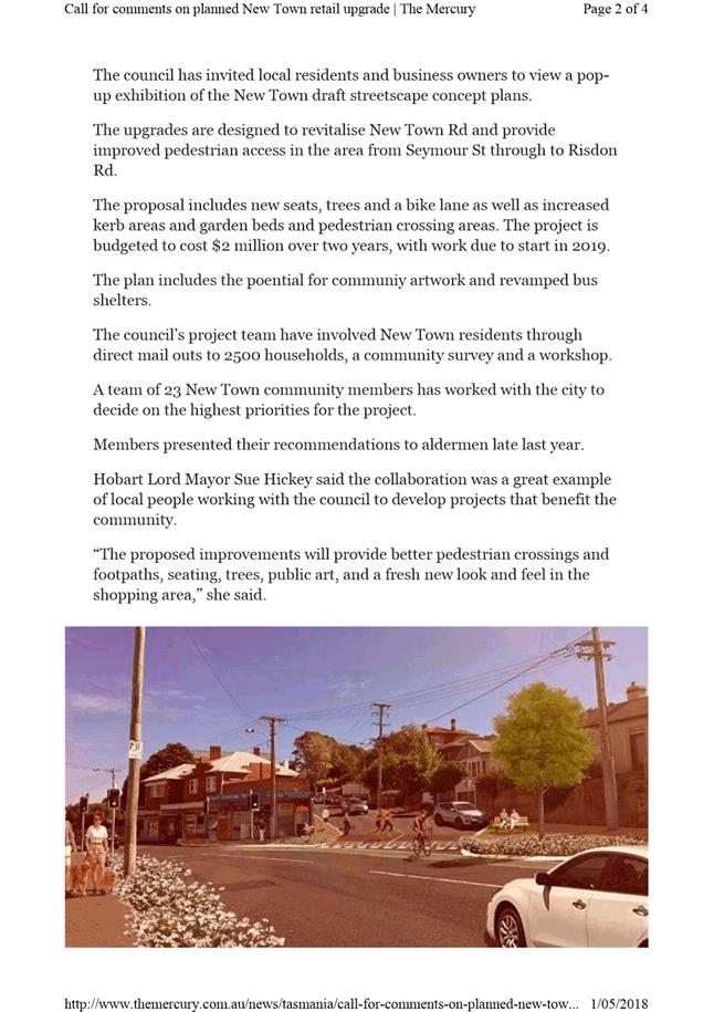
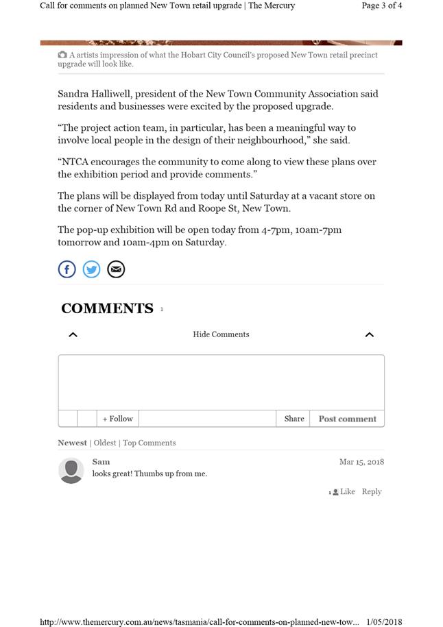
|
Agenda (Open Portion) City Infrastructure Committee Meeting - 30/5/2018 |
Page 63 ATTACHMENT c |

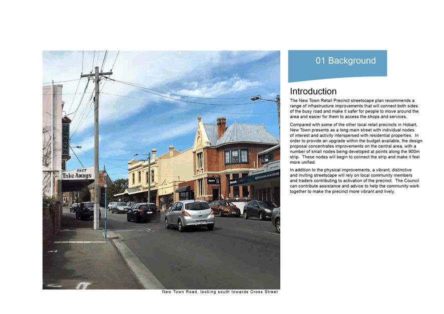
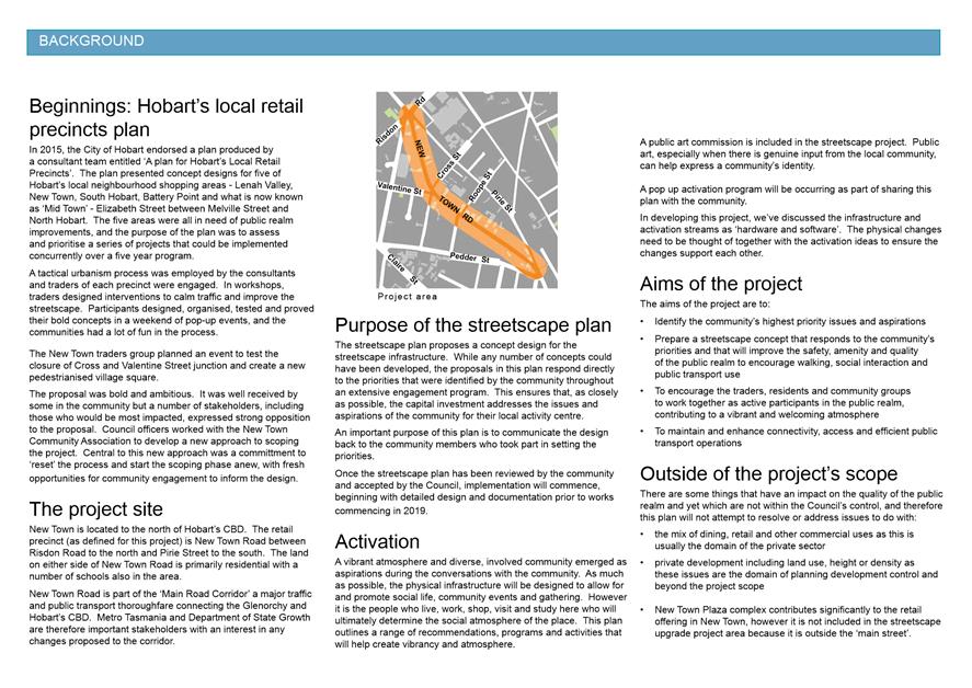
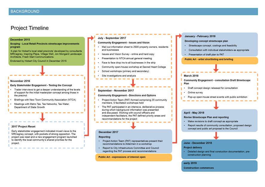
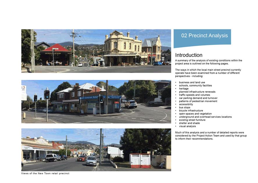
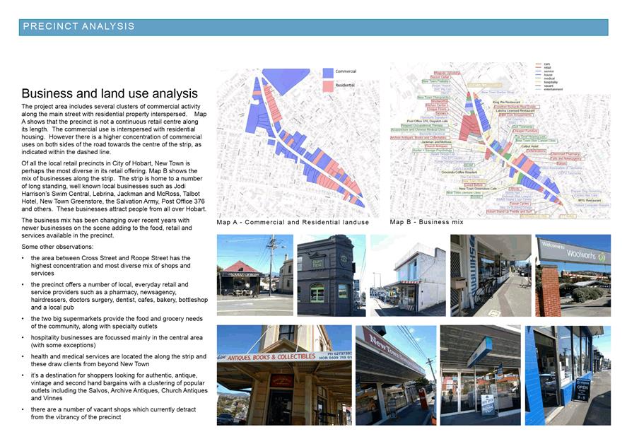
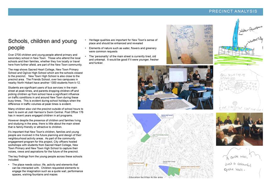
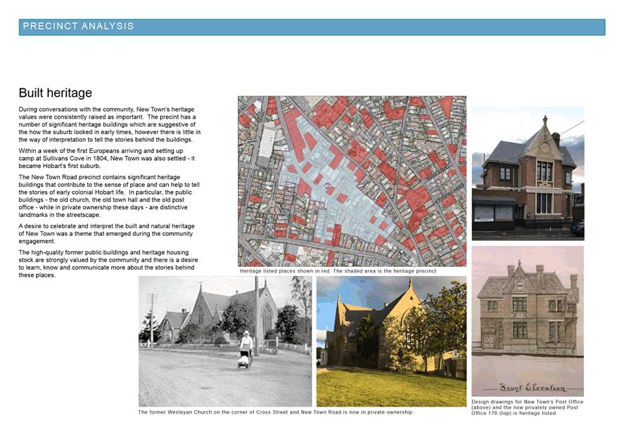
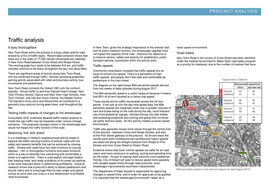
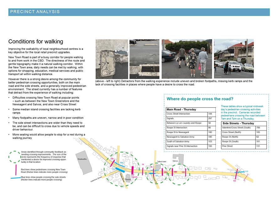
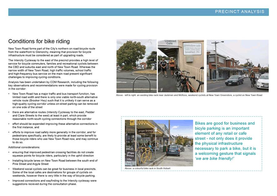
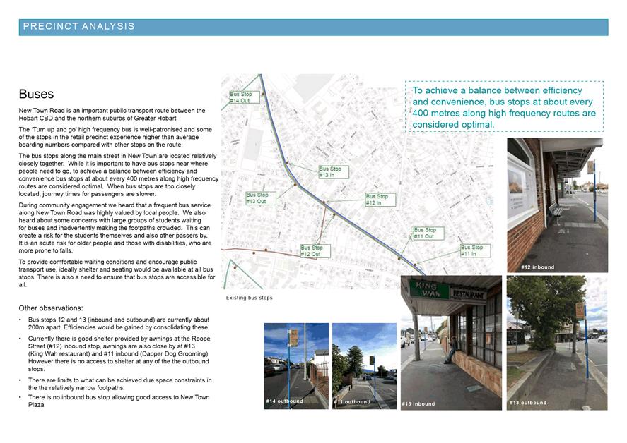
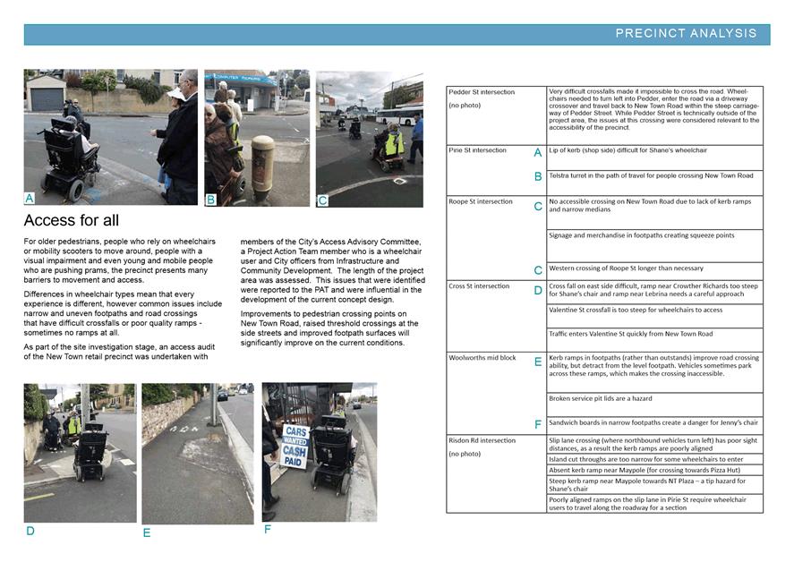
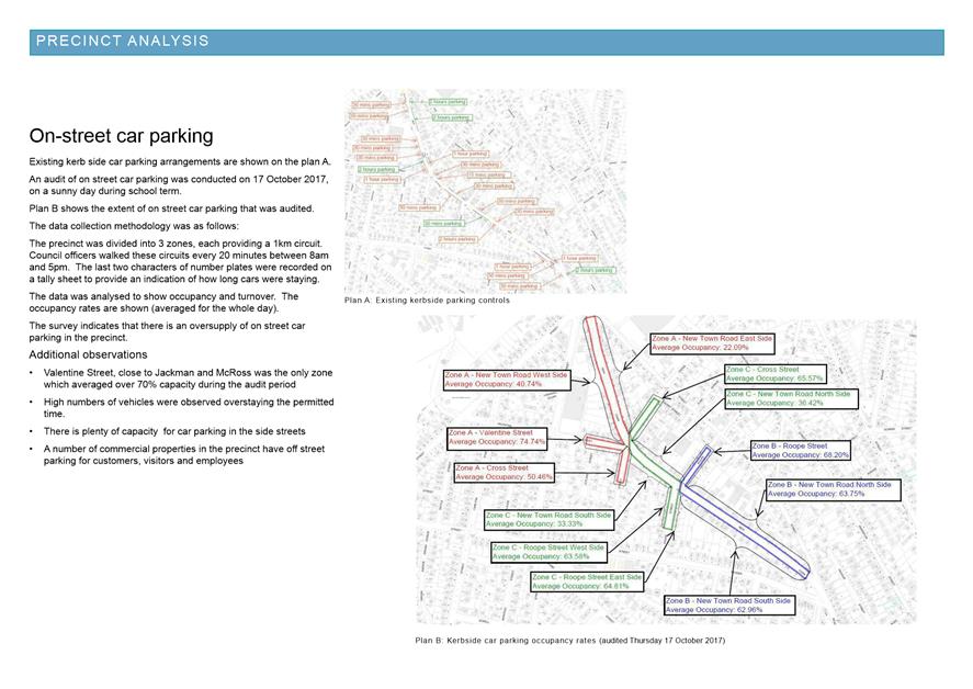
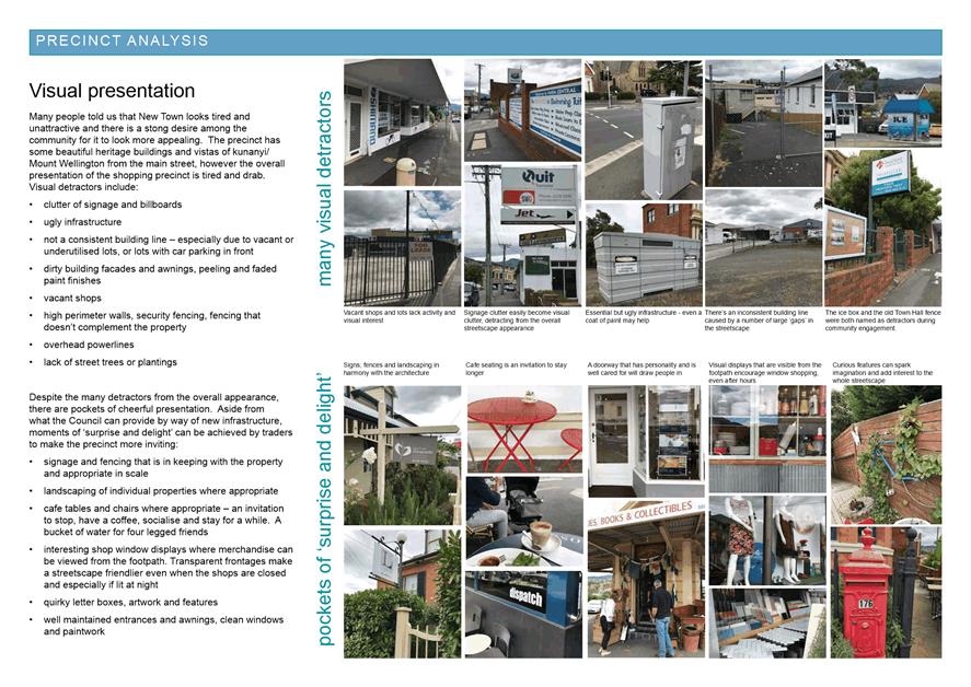
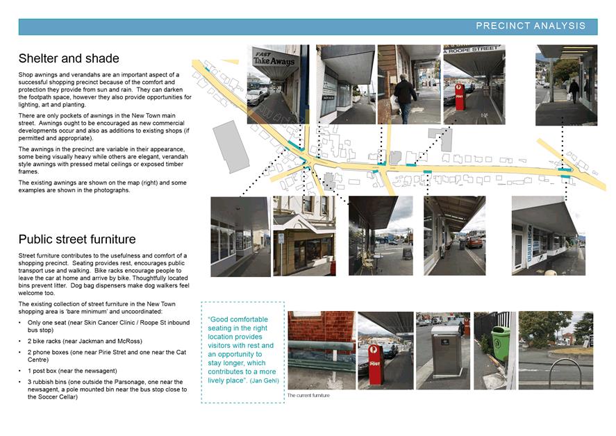
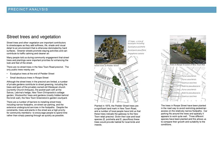
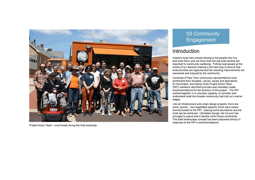
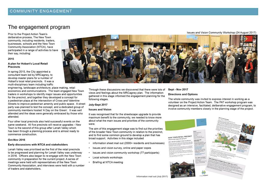
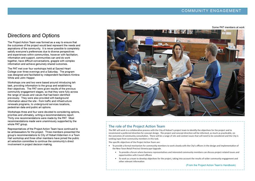
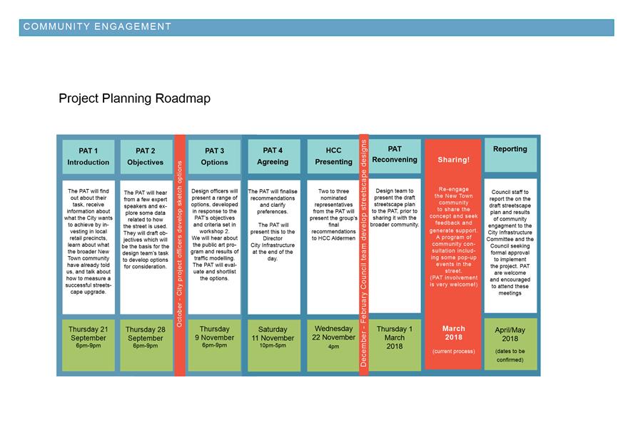
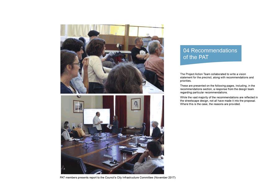
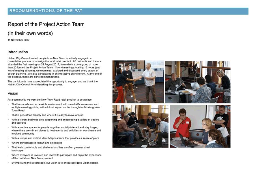
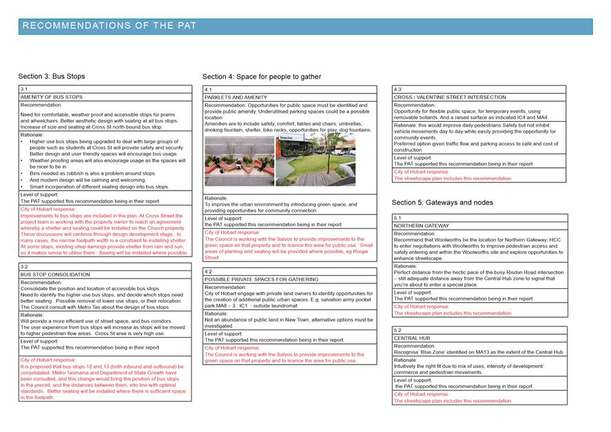
|
Agenda (Open Portion) City Infrastructure Committee Meeting - 30/5/2018 |
Page 96 ATTACHMENT d |
|
Agenda (Open Portion) City Infrastructure Committee Meeting - 30/5/2018 |
Page 99 ATTACHMENT e |
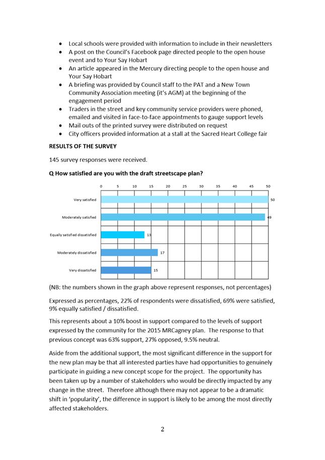
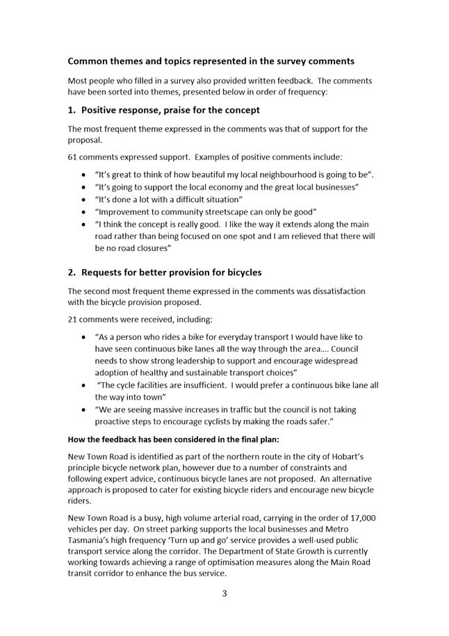
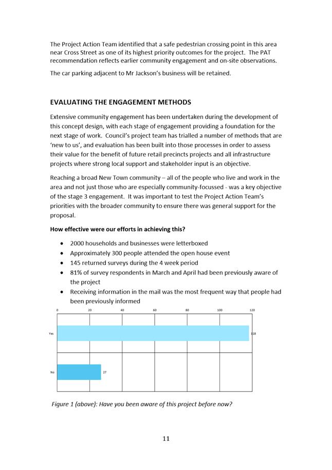
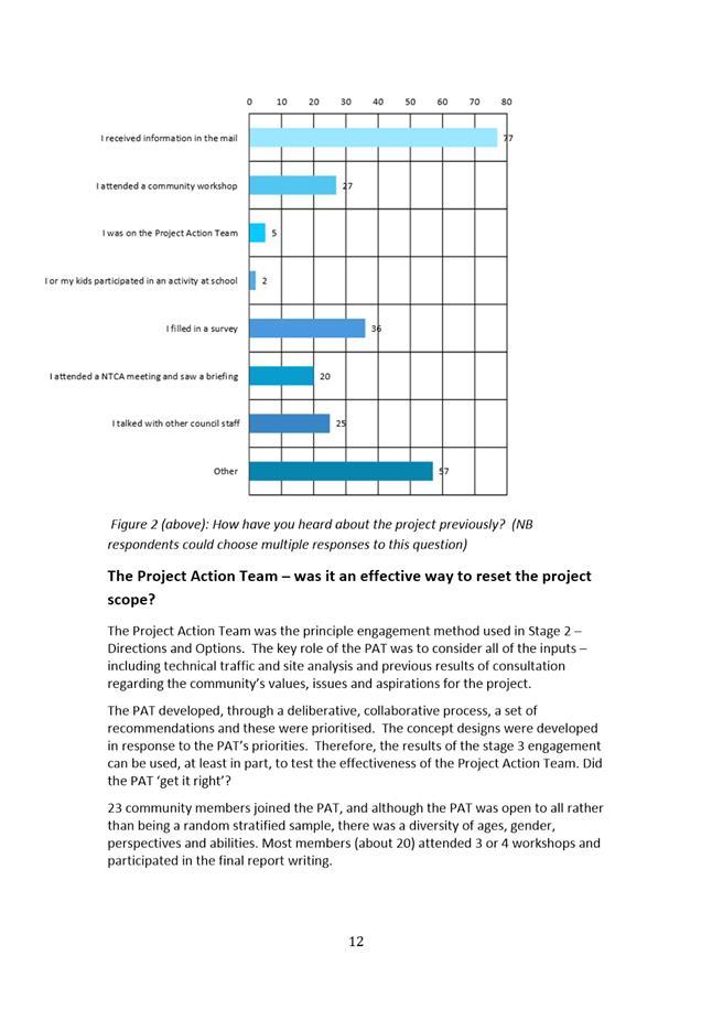
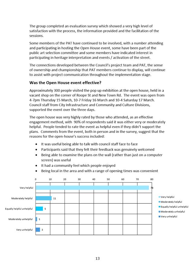
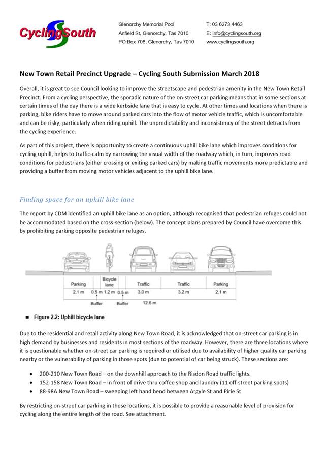
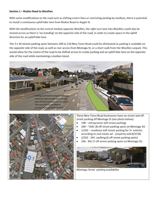
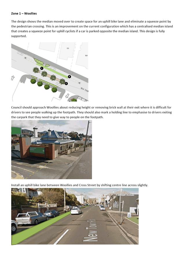
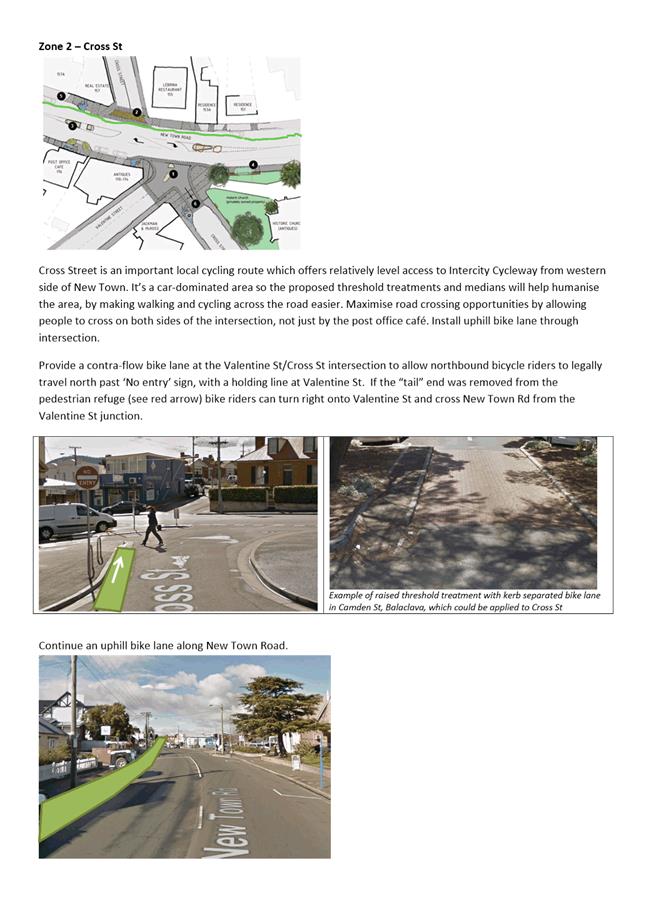
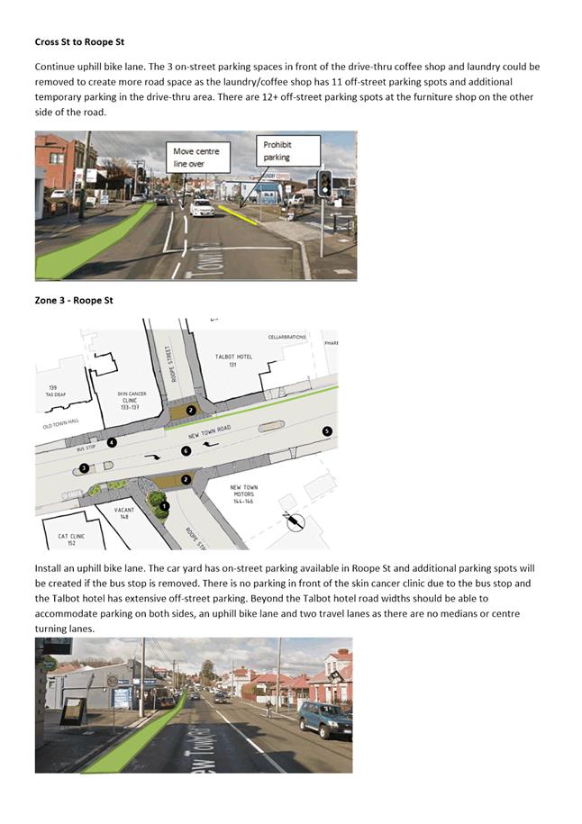
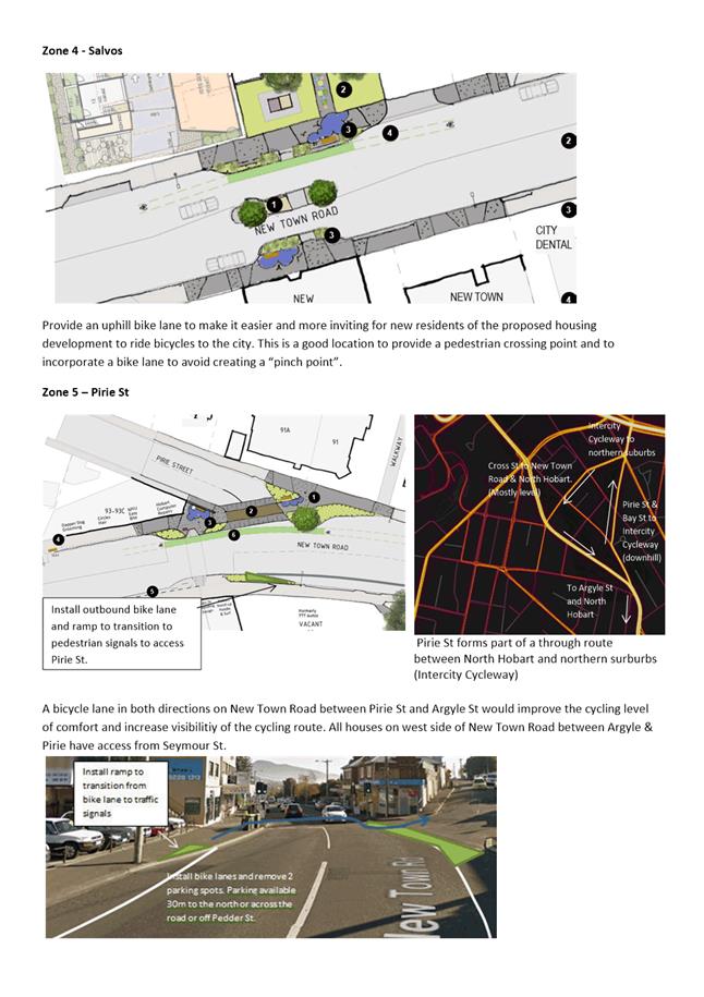
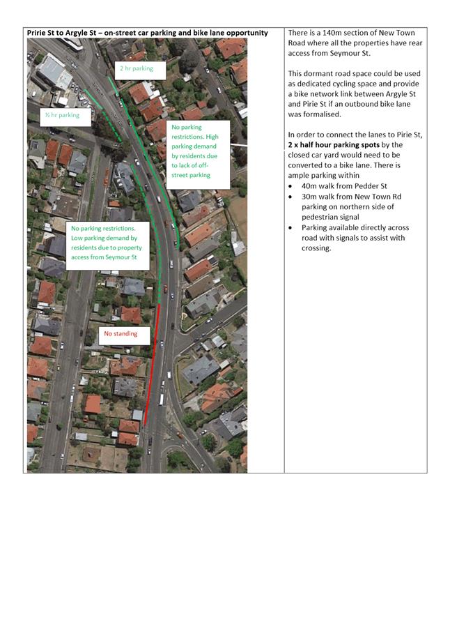
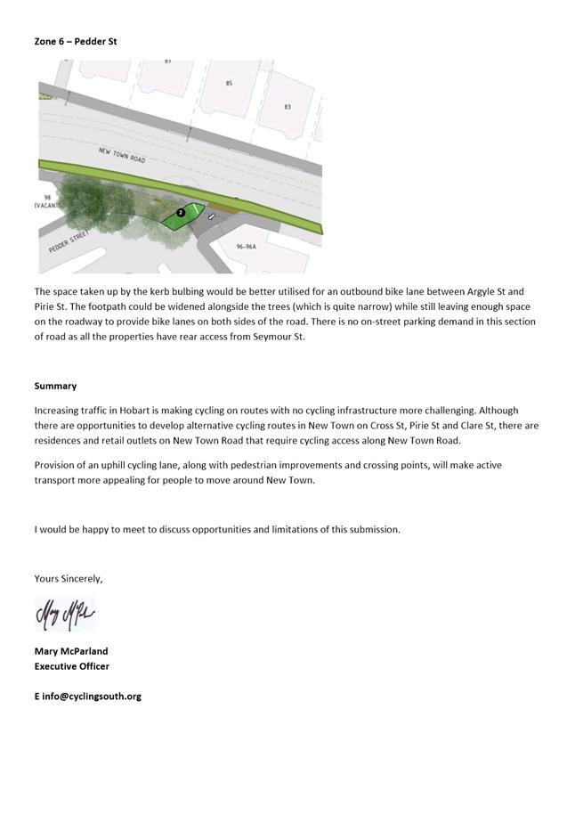
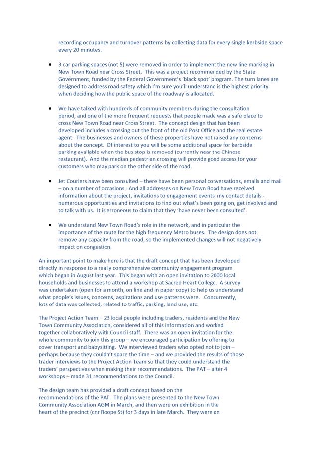
|
Agenda (Open Portion) City Infrastructure Committee Meeting - 30/5/2018 |
Page 128 ATTACHMENT f |
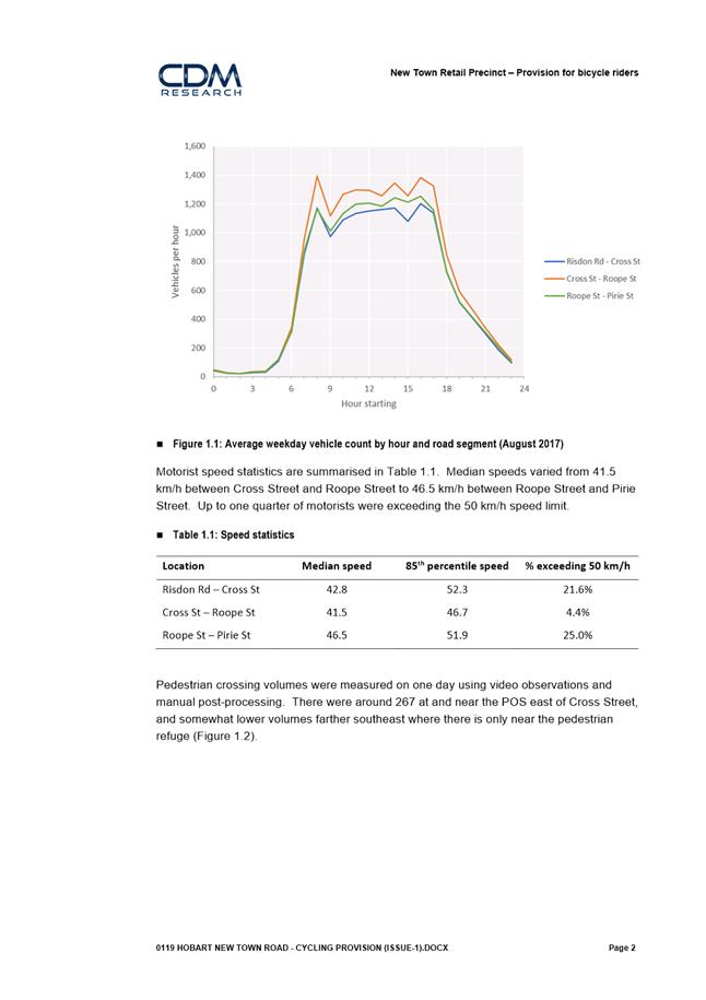
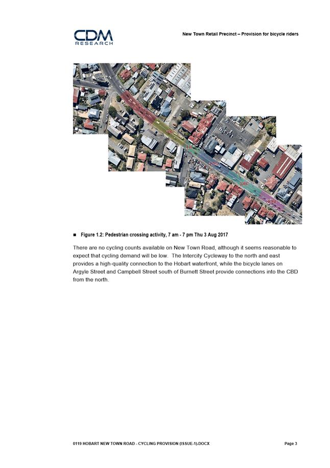
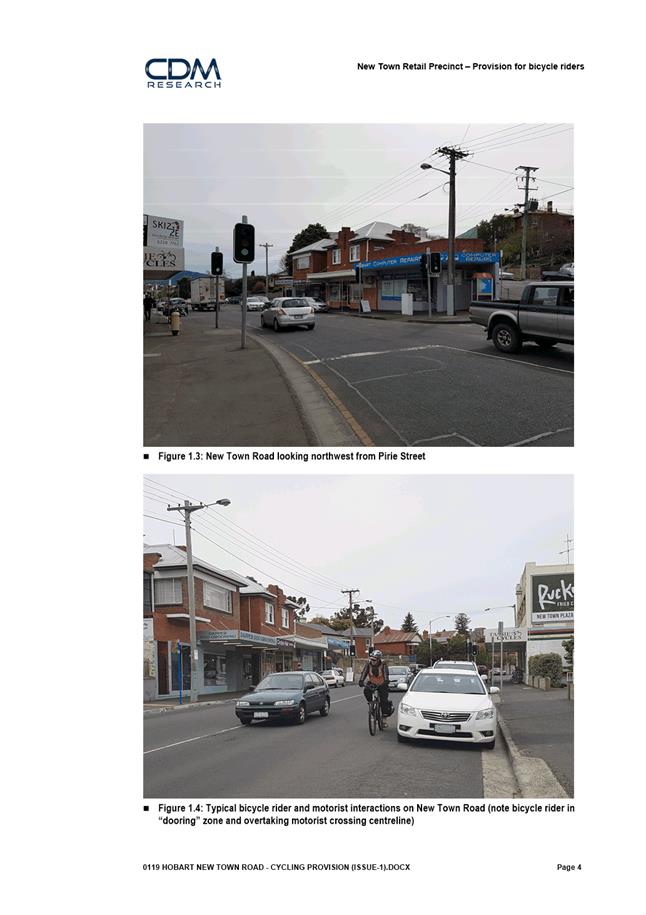
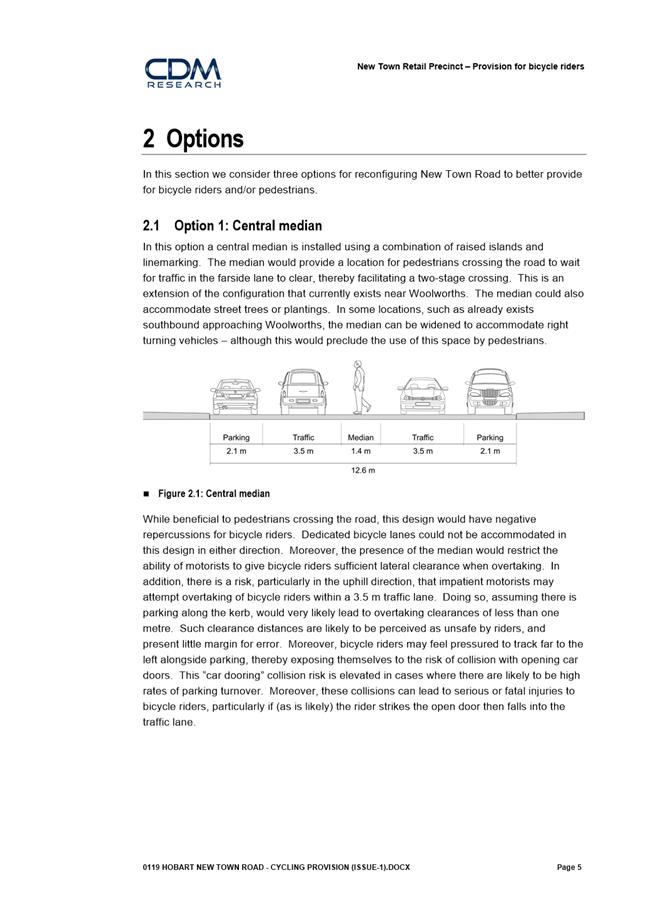
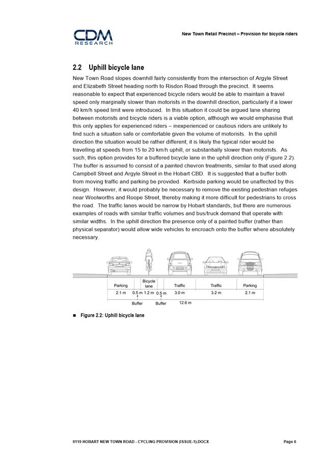
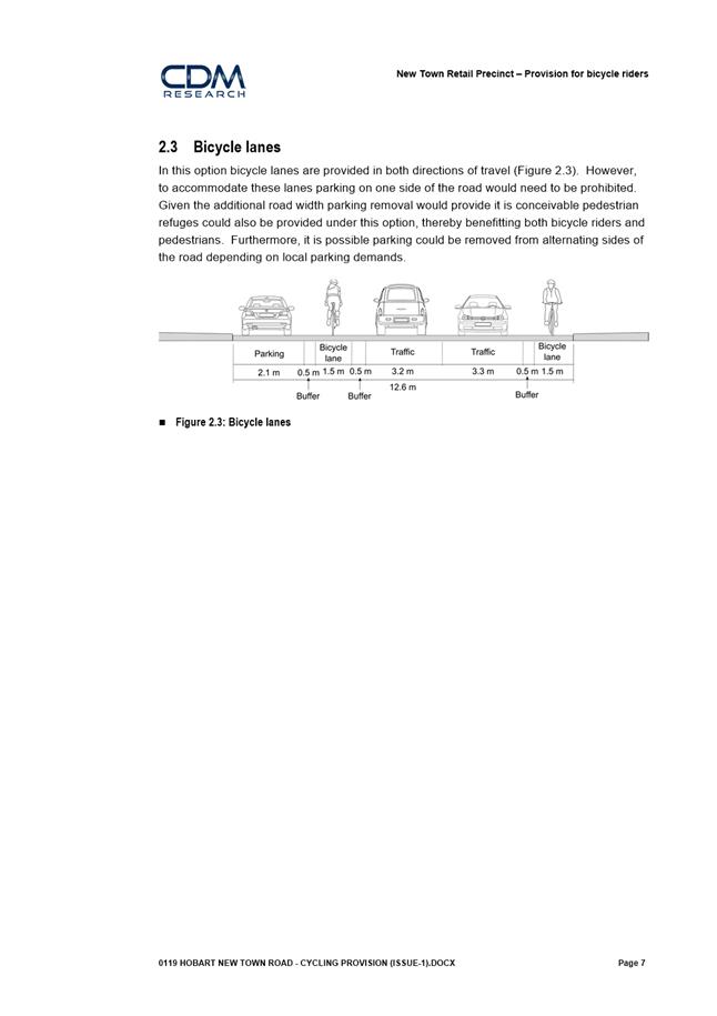
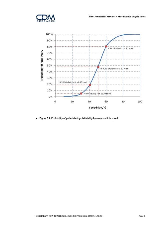
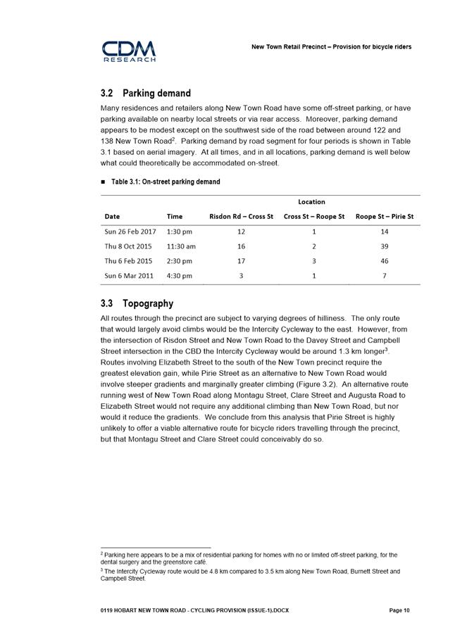
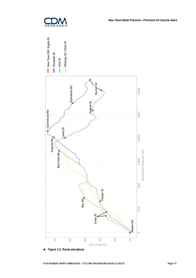
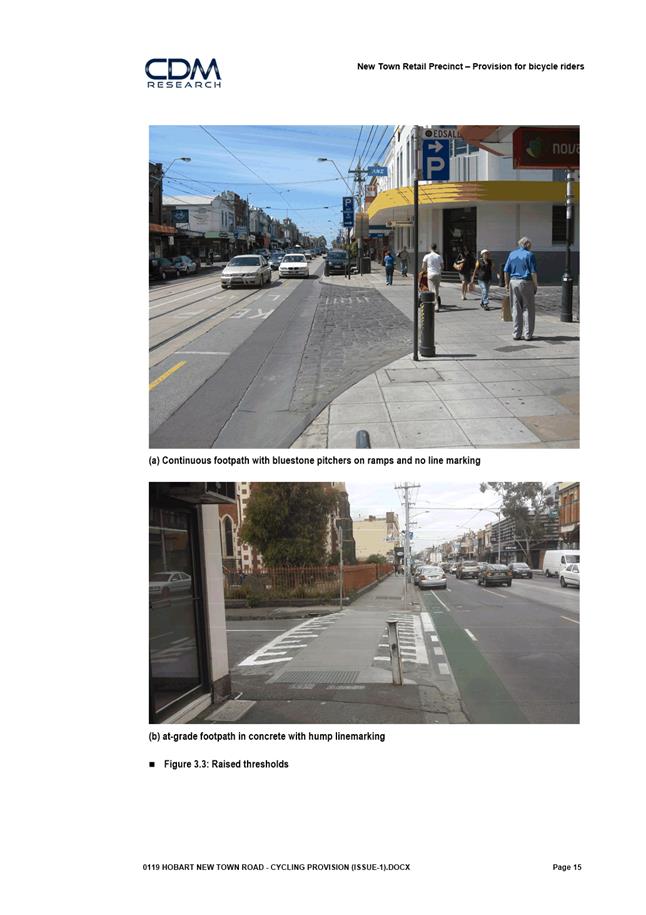
|
Agenda (Open Portion) City Infrastructure Committee Meeting |
Page 148 |
|
|
|
30/5/2018 |
|
6.3 Hobart Bicycle Advisory Committee Meeting Notes
Memorandum of the Director City Infrastructure of 23 May 2018 and attachment.
Delegation: Committee
|
Item No. 6.3 |
Agenda (Open Portion) City Infrastructure Committee Meeting |
Page 149 |
|
|
30/5/2018 |
|

Memorandum: City Infrastructure Committee
Hobart Bicycle Advisory Committee Meeting Notes
The Hobart Bicycle Advisory Committee met on 18 April 2018 and the draft
notes from the meeting are attached.
|
That the draft notes of the Hobart Bicycle Advisory Committee meeting of 18 April 2018 be received and noted.
|
As signatory to this report, I certify that, pursuant to Section 55(1) of the Local Government Act 1993, I hold no interest, as referred to in Section 49 of the Local Government Act 1993, in matters contained in this report.
|
Mark Painter Director City Infrastructure |
|
Date: 23 May 2018
File Reference: F18/40835; 37-1-4
Attachment a: Draft
Notes of the Hobart Bicycle Advisory Committee Meeting
Held 18 April 2018 ⇩ ![]()
|
Item No. 6.3 |
Agenda (Open Portion) City Infrastructure Committee Meeting - 30/5/2018 |
Page 150 ATTACHMENT a |
|
Agenda (Open Portion) City Infrastructure Committee Meeting |
Page 163 |
|
|
|
30/5/2018 |
|
7.1 City of Hobart Support for the Establishment of a Cooperative Research Centre – Waste and Plastic Pollution
Alderman Bill Harvey
Motion:
“That:
1. A report be prepared detailing how Council can support the establishment of a Waste and Plastic Pollution, Cooperative Research Centre (CRC) in Hobart under the auspices of the University of Tasmania, IMAS or CSIRO;
2. The Council engage with the Vice Chancellor urging his support to fund a bid for a CRC focusing on solutions to the waste and plastic pollution crisis effecting local governments, industry, communities and marine environment.”
Rationale:
“There is now a considerable body of evidence and understanding of the impacts of waste and plastic pollution. A comprehensive summary of the issue is available at the following link to a Senate Enquiry into marine plastics:
Waste management, litter and recycling are core responsibilities of LG and it is clear that there is increasing pressure on councils across the country and community expectations to tackle waste issues.
On the mainland, recycling services are under stress in some local government areas, while the cost of collection is rising. The cost of recycling is expected to increase in Tasmania also and domestic solutions to deal with recyclate need to be explored and developed. This evolving situation is due to changes in China’s policy to no longer accept the worlds contaminated and unsorted waste.
It is with growing urgency that innovative national and state based solutions are investigated through a collaborative model which would be created through the establishment of a CRC. The objective of a CRC is to bring together industry, local government, the community and an established research institution.
Hobart is perfectly placed to host a CRC focused on waste and plastic pollution. IMAS, CSIRO and UTas already have established researchers working in this field. The City of Hobart is now well recognised as a leader in waste management. There is strong community support for action on plastic pollution and industry is also looking for solutions and assistance with research and development.
A successful bid would benefit the city economically with multiple millions of dollars directed into research and commercialisation investment. Local government nationally needs to take a research and development approach working with industry to find solutions to the national waste and plastic pollution crisis.
This motion is not seeking funding from Council, but is seeking Council’s support for the establishment a CRC and to encourage UTas to support the preparation of a CRC bid. The level of local government involvement and potential financial commitment should also be explored.
Overview of a CRC
Establishing a CRC is a competitive process and requires considerable effort to establish a bid for funding. The cost of creating a bid is in the order of $150K. A successful bid would guarantee a Commonwealth financial commitment of $5m per year for ten years and would require matching funds in cash or in-kind from industry and other partners.
The following information is from:
The Cooperative Research Centres (CRC) Program supports industry-led collaborations between industry, researchers and the community. It’s a proven model for linking researchers with industry to focus on research and development towards use and commercialisation.
It aims to:
· Improve the competitiveness, productivity and sustainability of Australian industries, especially where Australia has a competitive strength and in line with government priorities.
· Foster high quality research to solve industry-identified problems through industry-led and outcome-focused collaborative research partnerships between industry entities and research organisations.
· Encourage and facilitate small and medium enterprise (SME) participation in collaborative research.
The overarching CRC Program offers support to industry, research and the community through two elements:
· Cooperative Research Centres (CRC) grants – to support medium to long term industry-led collaborative research, up to 10 years.
· Cooperative Research Centres Projects (CRC-P) grants – to support short term, industry-led collaborative research, up to 3 years.
Innovation and Science Australia and its CRC Advisory Committee, provide strategic oversight of the Program. They also provide advice to the Minister on matters including application assessments and recommendations in relation to selection processes.
Cooperative Research Centres (CRC) grants support medium to long term industry-led collaborations to solve industry problems and deliver tangible outcomes.
To support the overall aims of the CRC Program, CRCs undertake the following essential activities:
· Medium to long term industry-led high quality collaborative research to solve industry-identified problems and deliver outcomes consistent with Government Priorities, improving the competitiveness, productivity and sustainability of Australian industries.
· An industry-focused education and training program. This must include, but is not limited to, a PhD program that complements the research program and that increases engagement, technology development, skilled employees and R&D capacity within industry entities.
· Implementation of strategies that build the R&D capacity within SMEs.
· Deployment of research outputs and encouragement of take-up by industry.
CRC grants provide CRCs with up to 50% of the resources with no specified limit to funding available for each CRC. The CRC collaboration must at least match the amount of grant funding sought through cash and/or in-kind contributions. In-kind contributions are non-cash resources provided by participants in the CRC to conduct the activities of the CRC. They may be staff or non-staff resources.
You can use the funding to support the costs of:
· Research;
· Salaries;
· Student placements;
· Commercialisation;
· Capital items, such as equipment.
You cannot use CRC Program Funding for the same activities or project previously or currently financed through any other funding scheme.
CRCs will receive funding for a single, specified term to undertake the Activities in the Funding Agreement.
Applications are open to all industry sectors and research disciplines. To be eligible for a CRC grant, applications must:
· Be submitted by a group of applicants who have agreed to collaborate;
· The collaboration must, at a minimum, include one Australian industry organisation and one Australian research organisation;
· Demonstrate the ability to at least match the grant funding sought;
· Demonstrate the ability to undertake essential activities of a CRC as outlined in the CRC Program Guidelines.
For more information on eligibility please refer to the Program Guidelines.
The CRC Advisory Committee assesses CRC applications separately through a competitive, merit based process.
The selection criteria and weightings are:
1. The expected industry outcomes (30%).
2. The proposed research activities (30%).
3. Demonstrated governance and management capability (10%).
4. The proposed education and/or training program (10%).
5. Value for money (10%).
6. Expected national benefits (10%).
For more information on merit criteria please refer to the Program Guidelines.
The General Manager reports:
“In line with the Council’s policy in relation to Notices of Motion, I advise that the matter is considered to be within the jurisdiction of the Hobart City Council as it relates to The City of Hobart Waste Management Strategy 2015-2030.”
|
Agenda (Open Portion) City Infrastructure Committee Meeting |
Page 167 |
|
|
|
30/5/2018 |
|
A report indicating the status of current decisions is attached for the information of Aldermen.
REcommendation
That the information be received and noted.
Delegation: Committee
|
Item No. 8.1 |
Agenda (Open Portion) City Infrastructure Committee Meeting - 30/5/2018 |
Page 168 ATTACHMENT a |
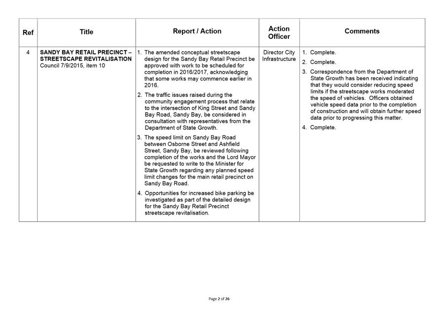
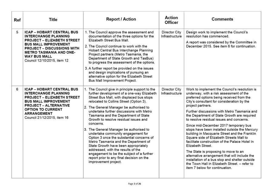
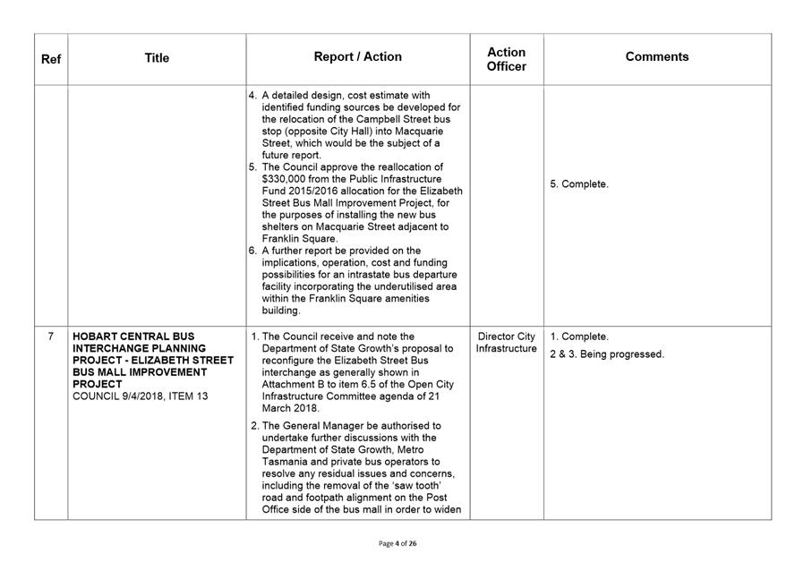
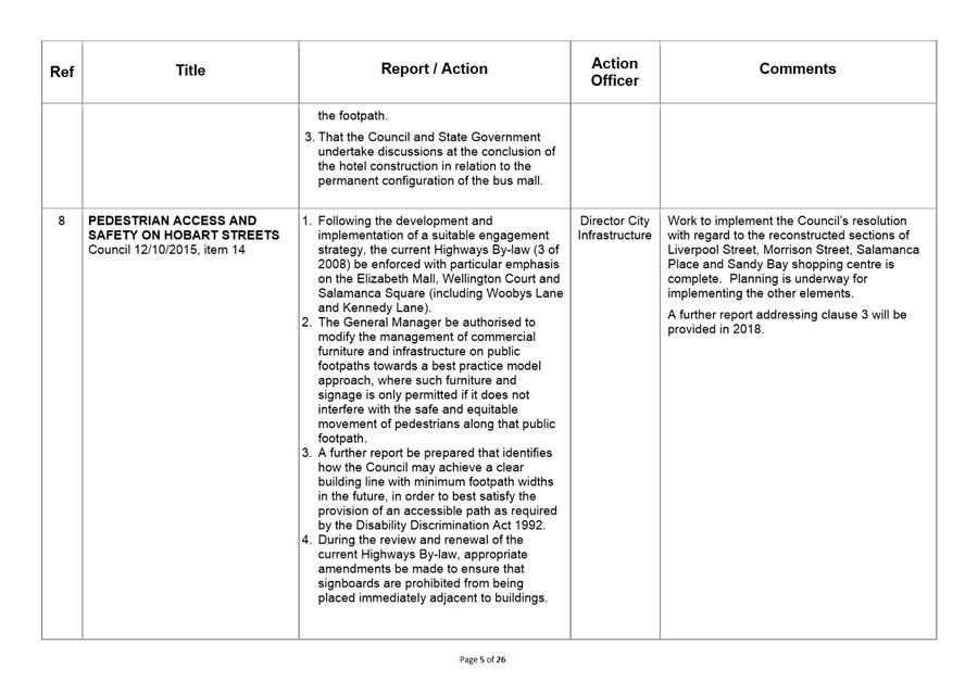
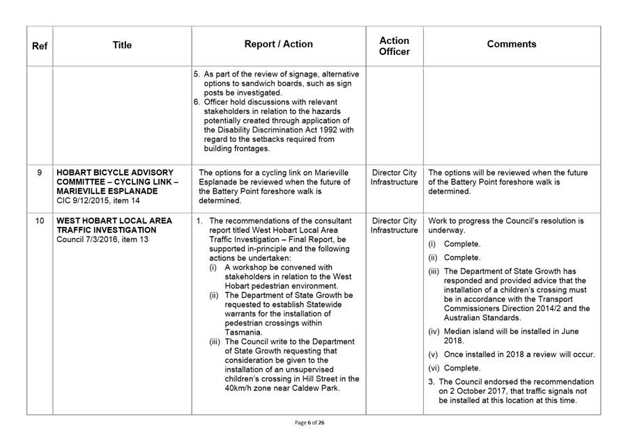
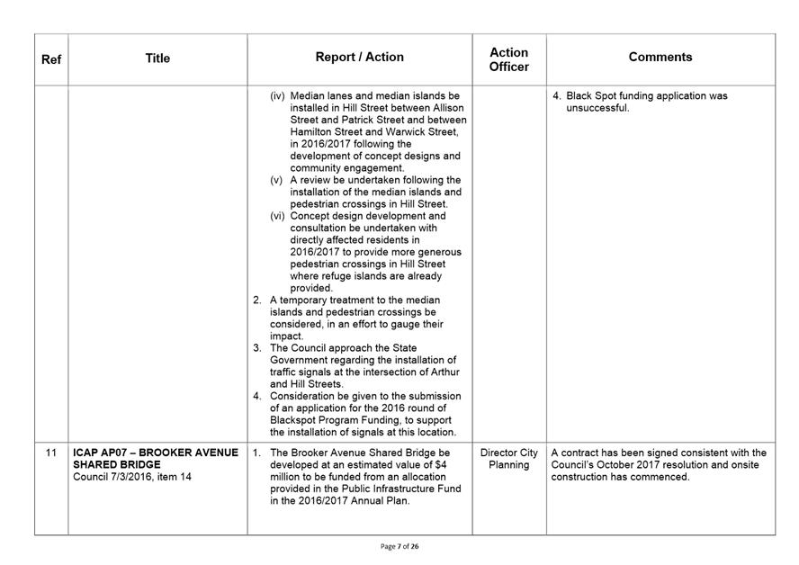
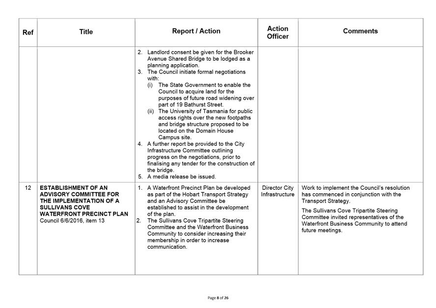
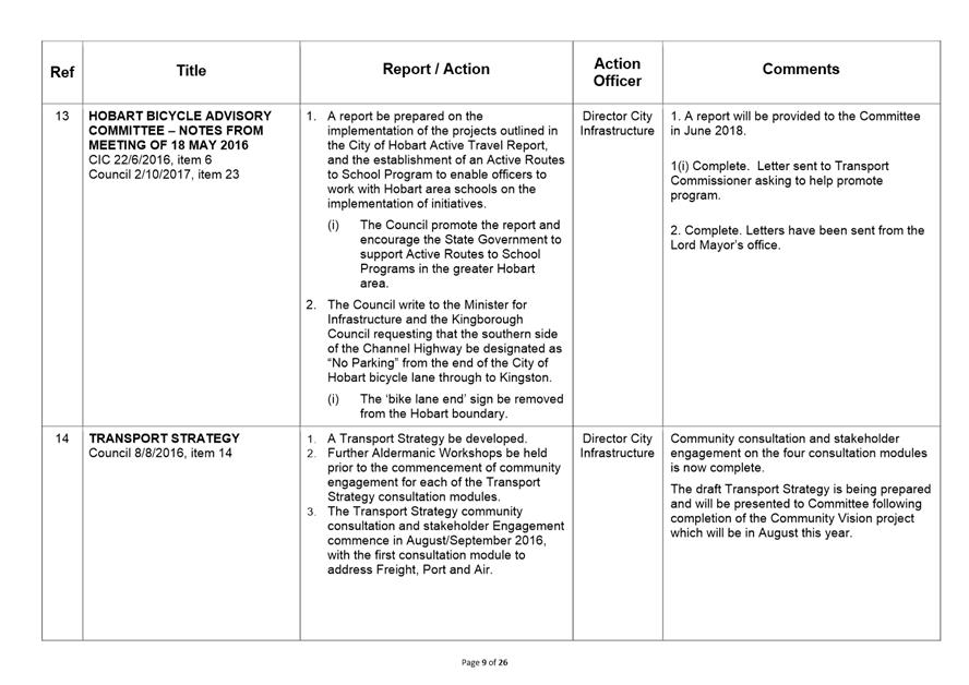
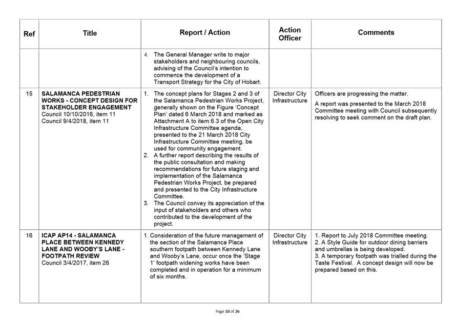
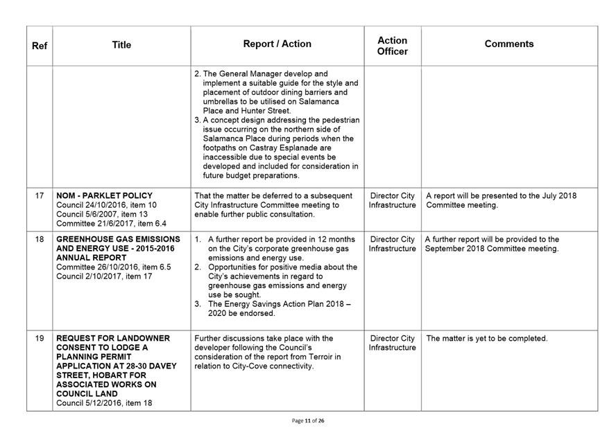
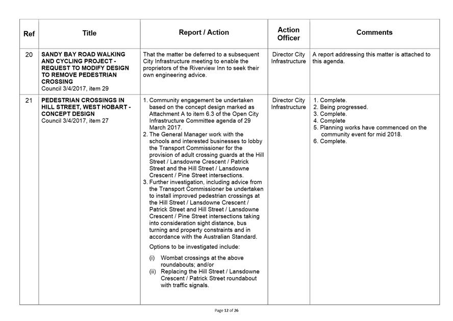
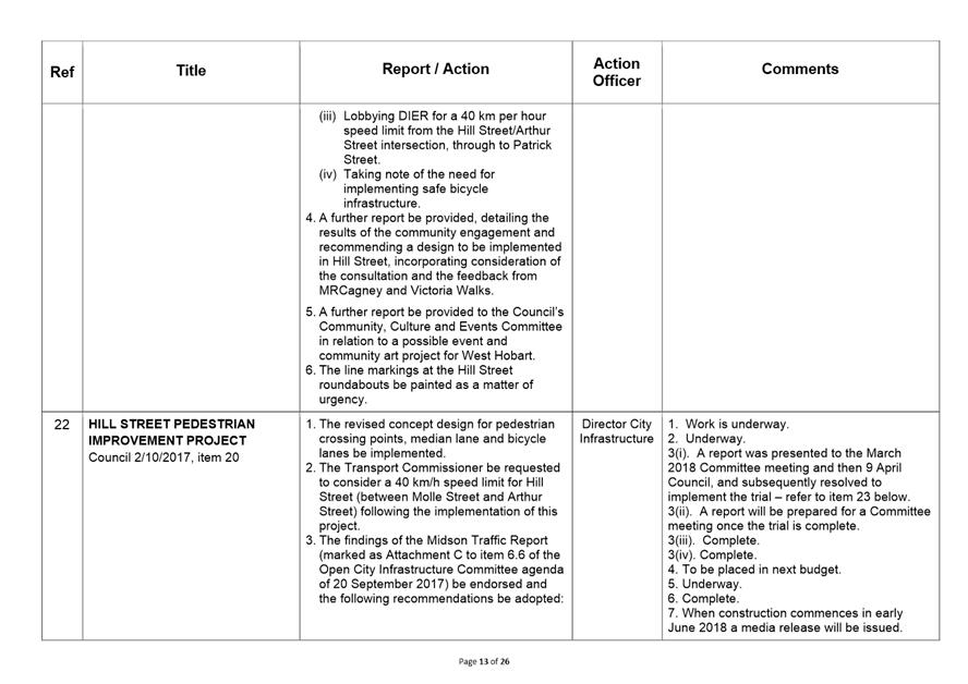
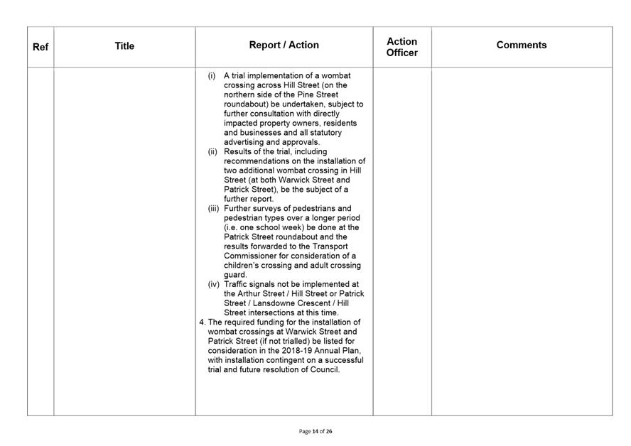
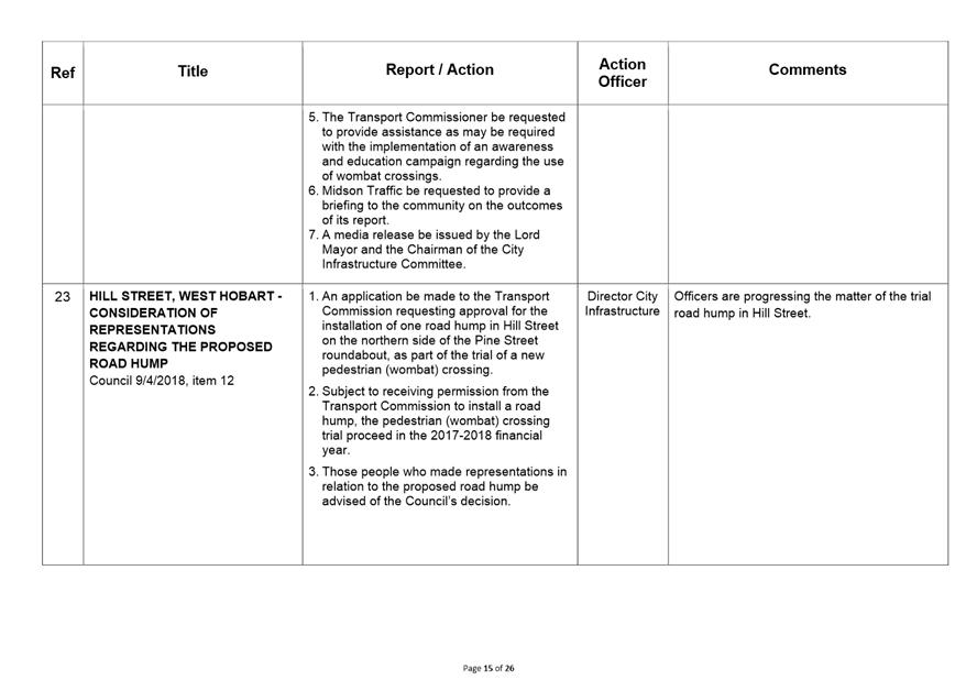
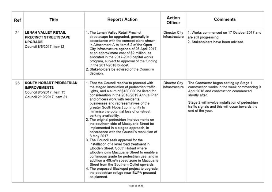
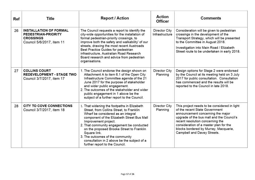
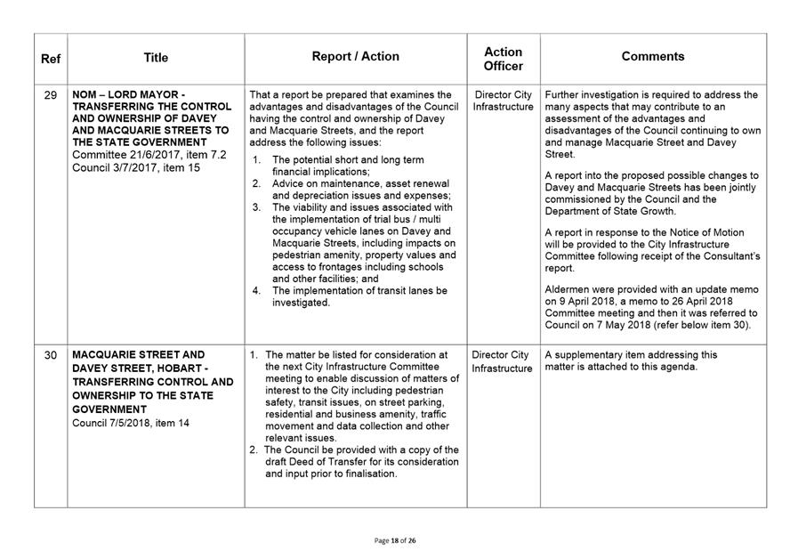
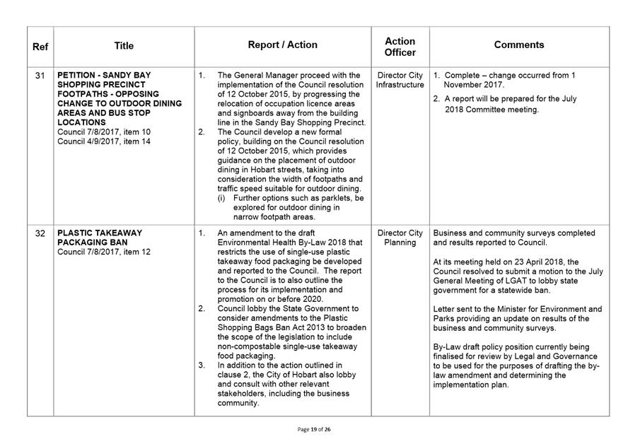
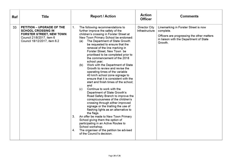
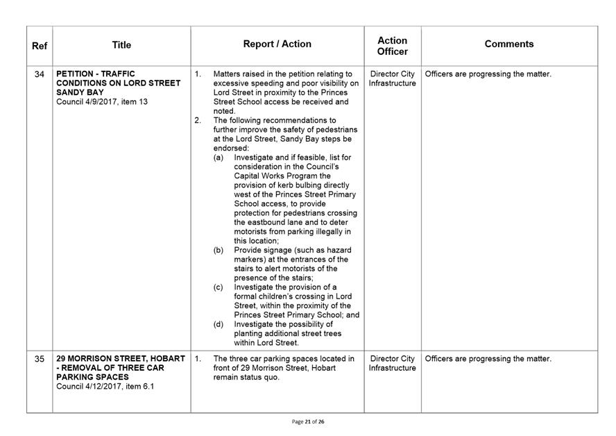
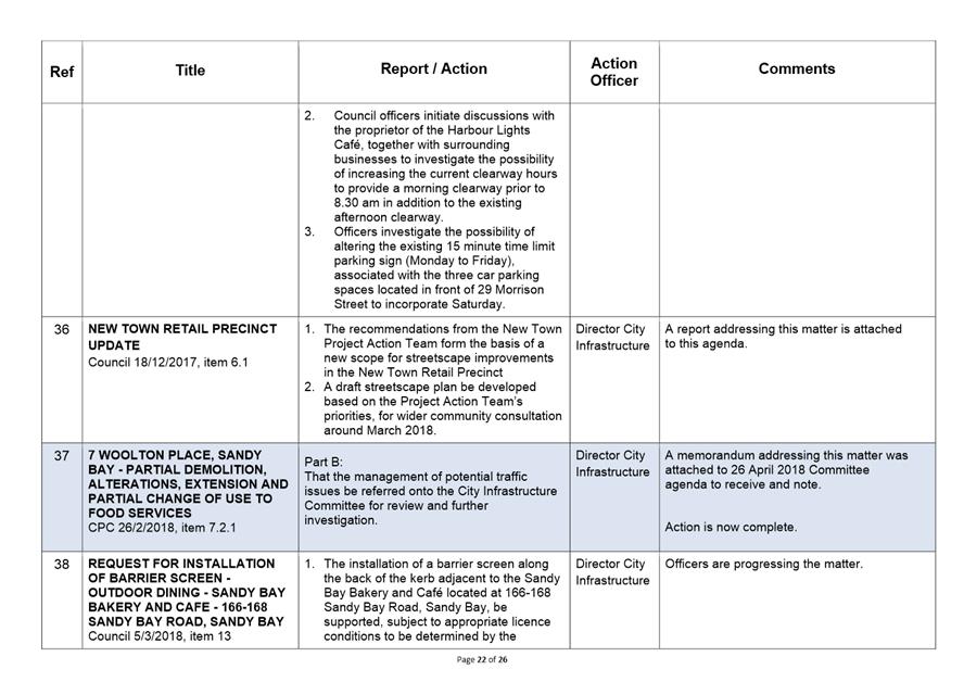
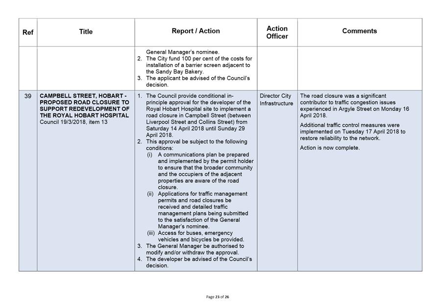
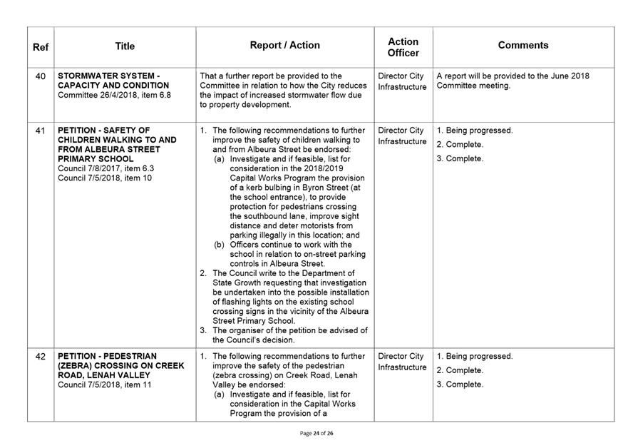
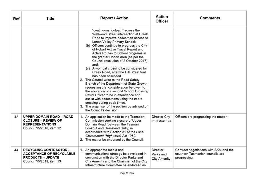
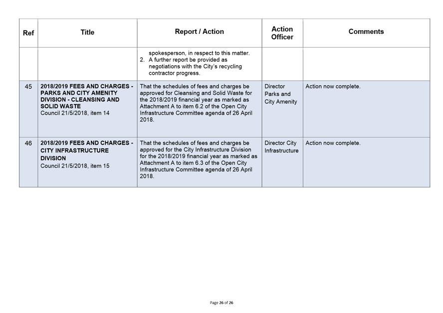
|
|
Agenda (Open Portion) City Infrastructure Committee Meeting |
Page 195 |
|
|
30/5/2018 |
|
Section 29 of the Local Government (Meeting Procedures) Regulations 2015.
File Ref: 13-1-10
An Alderman may ask a question without notice of the Chairman, another Alderman, the General Manager or the General Manager’s representative, in line with the following procedures:
1. The Chairman will refuse to accept a question without notice if it does not relate to the Terms of Reference of the Council committee at which it is asked.
2. In putting a question without notice, an Alderman must not:
(i) offer an argument or opinion; or
(ii) draw any inferences or make any imputations – except so far as may be necessary to explain the question.
3. The Chairman must not permit any debate of a question without notice or its answer.
4. The Chairman, Aldermen, General Manager or General Manager’s representative who is asked a question may decline to answer the question, if in the opinion of the respondent it is considered inappropriate due to its being unclear, insulting or improper.
5. The Chairman may require a question to be put in writing.
6. Where a question without notice is asked and answered at a meeting, both the question and the response will be recorded in the minutes of that meeting.
7. Where a response is not able to be provided at the meeting, the question will be taken on notice and
(i) the minutes of the meeting at which the question is asked will record the question and the fact that it has been taken on notice.
(ii) a written response will be provided to all Aldermen, at the appropriate time.
(iii) upon the answer to the question being circulated to Aldermen, both the question and the answer will be listed on the agenda for the next available ordinary meeting of the committee at which it was asked, where it will be listed for noting purposes only.
|
|
Agenda (Open Portion) City Infrastructure Committee Meeting |
Page 196 |
|
|
30/5/2018 |
|
|
That the Council resolve by absolute majority that the meeting be closed to the public pursuant to regulation 15(1) of the Local Government (Meeting Procedures) Regulations 2015 because the items included on the closed agenda contain the following matters:
· renewal of a contract including details of the terms and conditions of renewal; · information that was provided to the Council on the basis that it be kept confidential.
The following items are listed for discussion:-
Item No. 1 Minutes of the last meeting of the Closed Portion of the Council Meeting Item No. 2 Consideration of supplementary items to the agenda Item No. 3 Indications of pecuniary and conflicts of interest Item No. 4 Committee Action Status Report Item No. 4.1 Committee Actions - Status Report LG(MP)R 15(2)(g) Item No. 5 Questions Without Notice
|